ICT at the Service of Cultural Heritage
|
|
|
- Todd Arnold
- 8 years ago
- Views:
Transcription
1 ICT at the Service of Cultural Heritage Prof. Andreas Georgopoulos Lab. of Photogrammetry National Technical University of Athens

2 Cultural Heritage Structure Definition Identification of needs ICT Definition The role of CIPA-HD Contribution of ICT Data acquisition Processing software Alternative products Future outlook

3 Cultural Heritage Implies the monuments, but also every kind of document or evidence of civilization Carrier of historic memory and ark of national and global civilization. Tangible and Intangible Cultural Heritage.


4 Cultural Heritage Tangible Intangible ideas - traditions poetry literature - songs monuments dances performances - customs handicraft artifacts

5 Cultural Heritage is in need of Documentation (Geometric, Architectural, Historic etc.) 2D/3D for archiving, studies, planning etc. Accuracy/accurate measurements (for restoration, reconstructions, structural studies, protection etc.) Monitoring of its state Proper Management of its data (for sustainability, risk management etc.) Preservation possibilities (e.g. digital libraries etc.) Public Outreach (visualization, dissemination, awareness of the public )
 Monitoring of its state Proper Management of its data (for sustainability, risk management etc.")

6 Protection of Cultural Heritage Obligation of all generations for the preservation of historic memory International Conventions (Venice Charter, Granada Convention etc.) International Organizations for the protection of Cultural Heritage UNESCO ICOMOS (National ICOMOS Chapters) CIPA Heritage Documentation (with ISPRS)
 International Organizations for the protection of Cultural Heritage UNESCO")

7 International Cooperation ICOMOS 1964


8 The role of CIPA HD Encourage and promote development of principles and good practices for recording, documentation and information management of cultural heritage Lead and participate in international training programs for conservation and informatics professionals, students and site personnel; Advise government bodies, regional authorities, non-profit groups and institutions on tools, technology and methods for using technology; Promote an international network of professionals in both the fields of technology and cultural heritage for scientific research but also applied practical experience; Provide a platform with the bi-annual International Symposium for the exchange of ideas, best practices as well as scientific research papers. Become members and participate!!!

9 Interdisciplinarity Archaeology Art Historians Architecture Documenters Cultural Heritage ICT Specialists Structural Restitution Materials

10 Contribution of Digital Technologies To traditional professions Archaeologists Architects Conservators To the public To the younger generations and to fresh audiences UNESCO Charter for Digital Heritage (2003) Digital Libraries (e.g. Europeana) Today digitization of Cultural Heritage is possible!
 Digital Libraries (e.g. Europeana) Today digitization of Cultural Heritage is possible!")
11 What does ICT have to offer? Instrumentation Digital Sensors (optical, thermal, range etc.) Scanners Satellite navigation (GPS) LBS and indoor positioning systems 3D printers Digital Data Images or Video Points in 3D space H/W & S/W 3D data processing Image processing GIS - MIS Speed Accuracy Automation Alternative products

12 Data Acquisition Optical sensors Range sensors Underwater scanners Other sensors Mocap systems IPS (Indoor Positioning) LBS (Location Based Systems)
 LBS (Location")
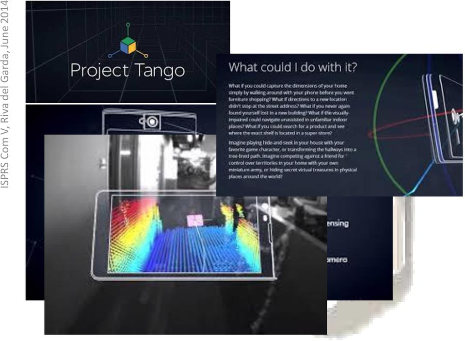
13 Digital Optical Cameras CCD/CMOS FoveonX3 (for better colour) Off-the-shelf Technological maturity Flexibility S/W development + technological advances Project Tango


14 Digital image capture

15


16 Range Sensors Fairly young technology Limited range Limited accuracy Fast developing


17 Scanners Laser Scanners (ToF or Phase shift) Structured light Scanners Underwater Scanners Zeb 1 Limited range High accuracy XYZRGB structured light scanner

 or information, analog FLV (flash) format data and associated information Actor as it data is recorded from the motion FBX capture the system. motion of the performer is saved as an actor.")
18 Motion capture systems Video Mocap data Dance recording using an HD camera. Data saved in MP4 (MPEG-4 C3D - stored part 3D 10 coordinate H.264) or information, analog FLV (flash) format data and associated information Actor as it data is recorded from the motion FBX capture the system. motion of the performer is saved as an actor. Any virtual character Character data (avatar) can be incorporated FBX to perform A virtual the character has been dance incorporated to the actor. Dr A. Aristidou, University of Cyprus


19 LBS and IPS Location based services & Indoor Positioning Systems


20 Platforms UAV Fixed wing Multi rotor Other ROV s


21 Processing S/W Image based SfM Oblique Images 3D Point cloud Management Big Data Cloud services
22 SfM Web based Arc3D (epoch) 123D Catch (AutoDesk) MS Photosynth Open Source FIT3D - Matlab Toolbox by I. Esteban SfM toolbox for Matlab by V. Rabaud Matlab Functions for Multiple View Geometry by A. Zissermann Structure and Motion Toolkit by Phil Torr Bundler - Structure from Motion for Unordered Photo Collections by Noah Snavely MicMac, a SFM open-source code released by the Institut Géographique National (FR) Python Photogrammetry Toolbox GUI by P. Moulon and Arc- Team
23 Commercial Photoscan by Agisoft SfM Smart3DCapture, by Acute3D. 3DF Samantha, by 3Dflow srl. Automatic Camera Tracking System (ACTS) A structure-frommotion system for Microsoft Windows, by State Key Lab of CAD&CG, Zhejiang University. VisualSFM: A Visual Structure from Motion System, by Changchang Wu SFMToolkit a complete photogrammetry solution based on open-source software MetaIO Toolbox SfM for augmented reality on mobile devices. Catena Python Abstract Workflow Framework with SfM components.

24 SfM BigSFM: Reconstructing the World from Internet Photos


25 SfM Toolkit

26 123D Catch

27 123D Catch Lab of Photogrammetry, NTUA
28 Virtual Alternative products Restoration Reconstruction Visits Augmented Reality applications Serious Games applications 3D printing


29 Lab of Photogrammetry, NTUA

30 Lab of Photogrammetry, NTUA

31 3D Virtual Reconstruction Lab of Photogrammetry, NTUA

32 3D Virtual Reconstruction Lab of Photogrammetry, NTUA

33 Augmented Reality M. Roussou, MakeBelieve M. Krauß & M. Bogen, Fraunhofer IAIS, Germany

34 Immersive environments

35 Serious Games RomaNova project Dr. F. Liarokapis, SGI & Coventry Univ.


36 3D printing
37 Concluding Remarks ICT definitely able to offer help 3D documentation exploration understanding of CH Hand-in-hand with traditional professions Interdisciplinarity is a must!! ICT should understand the needs Bridge the gap! Specs should be constantly updated


38 Thank you very much for you patience!!
BRIDGING THE GAP BETWEEN THE INFORMATION USER AND THE INFORMATION PROVIDER
 BRIDGING THE GAP BETWEEN THE INFORMATION USER AND THE INFORMATION PROVIDER Robin Letellier Chairperson, Working Group 1 and Vice-President of CIPA 93, Chemin Juniper Chelsea, Quebec, Canada, J9B 1T3 Phone:
THE PERFORMANCE EVALUATION OF MULTI-IMAGE 3D RECONSTRUCTION SOFTWARE WITH DIFFERENT SENSORS
 International Conference on Sensors & Models in Remote Sensing & Photogrammetry, 23 25 v 2015, Kish Island, Iran THE PERFORMANCE EVALUATION OF MULTI-IMAGE 3D RECONSTRUCTION SOFTWARE WITH DIFFERENT SENSORS
Open Source Tools for 3D Forensic Reconstructions Part 3 Eugene Liscio, P. Eng. November 2011
 Page 1 of 7 Open Source Tools for 3D Forensic Reconstructions Part 3 Eugene Liscio, P. Eng. November 2011 In the past several years, there have been some interesting developments and availability of open
PROPOSED FINAL DRAFT. Revised under the Auspices of the ICOMOS International Scientific Committee on Interpretation and Presentation.
 The ICOMOS Charter for the Interpretation and Presentation of Cultural Heritage Sites PROPOSED FINAL DRAFT Revised under the Auspices of the ICOMOS International Scientific Committee on Interpretation
Photogrammetric Point Clouds
 Photogrammetric Point Clouds Origins of digital point clouds: Basics have been around since the 1980s. Images had to be referenced to one another. The user had to specify either where the camera was in
Quality management of 3D cultural heritage replicas with CIDOC-CRM
 Quality management of 3D cultural heritage replicas with CIDOC-CRM Nicola Amico 1, Paola Ronzino 1, Achille Felicetti 1, Franco Niccolucci 2 1 PIN, VAST-LAB, Prato, Italy {nicola.amico, paola.ronzino,
Research trends in photogrammetry, science and the role of ISPRS
 Research trends in photogrammetry, remote sensing and GI science and the role of ISPRS Christian Heipke IPI - Institute for Photogrammetry and GeoInformation Leibniz Universität Hannover Secretary General,
CHARTER FOR THE PROTECTION AND MANAGEMENT OF THE ARCHAEOLOGICAL HERITAGE (1990)
") CHARTER FOR THE PROTECTION AND MANAGEMENT OF THE ARCHAEOLOGICAL HERITAGE (1990) Prepared by the International Committee for the Management of Archaeological Heritage (ICAHM) an approved by the 9th General
CHARTER FOR THE PROTECTION AND MANAGEMENT OF THE ARCHAEOLOGICAL HERITAGE (1990) Prepared by the International Committee for the Management of Archaeological Heritage (ICAHM) an approved by the 9th General
3D Modeling of Monuments: Recent Work of the IU Virtual World Heritage Laboratory
 3D Modeling of Monuments: Recent Work of the IU Virtual World Heritage Laboratory ` Bernard Frischer Virtual World Heritage Laboratory, Indiana University April 16, 2015 AGENDA Mission of the VWHL Most
The obligation to conserve the heritage of the twentieth century is as important as our duty to conserve the significant heritage of previous eras.
 The ICOMOS International Scientific Committee for Twentieth Century Heritage (ISC 20C) is developing guidelines for the conservation of heritage sites of the twentieth century during 2011 2012. As a contribution
3D MODELING OF LARGE AND COMPLEX SITE USING MULTI-SENSOR INTEGRATION AND MULTI-RESOLUTION DATA
 3D MODELING OF LARGE AND COMPLEX SITE USING MULTI-SENSOR INTEGRATION AND MULTI-RESOLUTION DATA G. Guidi 1, F. Remondino 2, 3, M. Russo 1, F. Menna 4, A. Rizzi 3 1 Dept.INDACO, Politecnico of Milano, Italy
The acquisition of appearance properties of real objects: state of the art, challenges, perspectives
 The acquisition of appearance properties of real objects: state of the art, challenges, perspectives Matteo Dellepiane Visual Computing Lab, ISTI-CNR Pisa 26th February 2015 The research leading to these
HIGH AND LOW RESOLUTION TEXTURED MODELS OF COMPLEX ARCHITECTURAL SURFACES
 HIGH AND LOW RESOLUTION TEXTURED MODELS OF COMPLEX ARCHITECTURAL SURFACES E. K. Stathopoulou a, A. Valanis a, J. L. Lerma b, A. Georgopoulos a a Laboratory of Photogrammetry, National Technical University
The Paris Declaration On heritage as a driver of development Adopted at Paris, UNESCO headquarters, on Thursday 1st December 2011
 The Paris Declaration On heritage as a driver of development Adopted at Paris, UNESCO headquarters, on Thursday 1st December 2011 Preamble The 1 150 participants from 106 countries gathered in Paris at
GOTHIC CHURCHES IN PARIS ST GERVAIS ET ST PROTAIS IMAGE MATCHING 3D RECONSTRUCTION TO UNDERSTAND THE VAULTS SYSTEM GEOMETRY
 GOTHIC CHURCHES IN PARIS ST GERVAIS ET ST PROTAIS IMAGE MATCHING 3D RECONSTRUCTION TO UNDERSTAND THE VAULTS SYSTEM GEOMETRY M.Capone a,, M. Campi b, R. Catuogno c a DiARC Dipartimento di Architettura Università
How To Preserve An Ancient City
 Shared Legacy, Common Responsibility International Workshop for the Recovery of Bam s Cultural Heritage Bam City, Kerman Province, Islamic Republic of Iran 17-20 April 2004 Declaration and Concluding Recommendations
Digital Dunhuang: : A Case Study for Digital Preservation and Digital Asset Management
 Digital Dunhuang: : A Case Study for Digital Preservation and Digital Asset Management Peter Zhou UC Berkeley PRDLA Annual Meeting, Los Angeles, November 9, 2011 从 多 个 角 度 演 绎 了 敦 煌 及 莫 高 窟 的 形 成 与 发 展,
RECOMMENDATION CONCERNING THE PROTECTION AND PROMOTION OF MUSEUMS AND COLLECTIONS, THEIR DIVERSITY AND THEIR ROLE IN SOCIETY
 RECOMMENDATION CONCERNING THE PROTECTION AND PROMOTION OF MUSEUMS AND COLLECTIONS, THEIR DIVERSITY AND THEIR ROLE IN SOCIETY Paris, 20 November 2015 UNITED NATIONS EDUCATIONAL, SCIENTIFIC AND CULTURAL
ACCURACY ASSESSMENT OF BUILDING POINT CLOUDS AUTOMATICALLY GENERATED FROM IPHONE IMAGES
 ACCURACY ASSESSMENT OF BUILDING POINT CLOUDS AUTOMATICALLY GENERATED FROM IPHONE IMAGES B. Sirmacek, R. Lindenbergh Delft University of Technology, Department of Geoscience and Remote Sensing, Stevinweg
Digital Documentation of Cultural Heritage Objects using hybrid recording techniques
 The 7th International Symposium on Virtual Reality, Archaeology and Cultural Heritage VAST (2006) M. Ioannides, D. Arnold, F. Niccolucci, K. Mania (Editors) Project Papers Digital Documentation of Cultural
A PRESERVATION CHARTER FOR THE HISTORIC TOWNS AND AR- EAS OF THE U. S.
 A PRESERVATION CHARTER FOR THE HISTORIC TOWNS AND AR- EAS OF THE U. S. US/ICOMOS Committee on Historic Towns (1992) Since the 1960s both the national and international preservation movements have stressed
Office presentation ProDenkmal
 Office Bamberg / Laboratory Obere Königstr. 15 96052 Bamberg phone: +49 (0)951-208 290 8 fax: +49 (0)951-208 290 9 Office Berlin Geschwister-Scholl-Str. 5 10117 Berlin phone: 030-280 930-0 fax: 030-280
Data Data Everywhere, We are now in the Big Data era
 Data Data Everywhere, We are now in the Big Data era Mike Liddell 13 th March 2014 UUVs @ OI 2014 Contents Menu Background Big Data What is Generating our Big Data Physical Management of Big Data Optimisation
Multimedia Systems Hardware & Software THETOPPERSWAY.COM
 Multimedia Systems Hardware & Software THETOPPERSWAY.COM Table of Content 1. Categories of multimedia systems 2. Categories of multimedia devices 3. Evolution of multimedia PC 4. Authoring tools 5. Classification
3D Vision Based Mobile Mapping and Cloud- Based Geoinformation Services
 3D Vision Based Mobile Mapping and Cloud- Based Geoinformation Services Prof. Dr. Stephan Nebiker FHNW University of Applied Sciences and Arts Northwestern Switzerland Institute of Geomatics Engineering,
3DVEM SOFTWARE MODULES FOR EFFICIENT MANAGEMENT OF POINT CLOUDS AND PHOTOREALISTIC 3D MODELS
 3DVEM SOFTWARE MODULES FOR EFFICIENT MANAGEMENT OF POINT CLOUDS AND PHOTOREALISTIC 3D MODELS S. Fabado, A. E. Seguí, M. Cabrelles, S. Navarro, D. García-De-San-Miguel, J. L. Lerma* Photogrammetry & Laser
Knowledge Management (KM) and Museums
 and Museums") Management (KM) and Museums Kamani Perera Librarian Regional Centre for Strategic Studies Sri Lanka k_vithana@yahoo.com +94775965252 (M) Dinesh Chandra Section Officer Ministry of Defence Government of
Management (KM) and Museums Kamani Perera Librarian Regional Centre for Strategic Studies Sri Lanka k_vithana@yahoo.com +94775965252 (M) Dinesh Chandra Section Officer Ministry of Defence Government of
3D BYZANTINEB 3D ARCHAEOA. 3D Crypts. 3D Sub Divo RCHAEO
 Electronic Imaging 2003 20/01/2003 Electronic Imaging 2003 Santa Clara, California Videometrics VII Wednesday 22 January Santa Clara, USA J-A Beraldin(1), Picard(1), El-Hakim(1), M. S.F. G. V. Valzano(2),
JEDDAH HISTORICAL BUILDING INFORMATION MODELING "JHBIM" OLD JEDDAH - SAUDI ARABIA
 JEDDAH HISTORICAL BUILDING INFORMATION MODELING "JHBIM" OLD JEDDAH - SAUDI ARABIA A.Baik a,, J. boehm b, S. Robson c a Dept. of Geomatic Engineering, University College London, Gower Street, London, WC1E
Greg Colley, Suave Aerial Photographers
 Greg Colley, Suave Aerial Photographers Use of UAVs and low cost software for surveys of heritage sites 1. Introduction 2. Case Study: Chester Amphitheatre 3. Case Study: Chester Walls 4. Project and Equipment
HEXAGON GEOSPATIAL BENELUX 2015. Hexagon Geospatial Benelux 2015
 HEXAGON GEOSPATIAL BENELUX 2015 IMAGINE for UAV Irmgard Runkel GEOSYSTEMS GmbH, Germany Are drones a new market*? > 50 % * http://dronelife.com/2015/08/28/the-latest-drone-numbers-from-cb-insights-future-of-frontier-tech-report/
Digital Image Increase
 Exploiting redundancy for reliable aerial computer vision 1 Digital Image Increase 2 Images Worldwide 3 Terrestrial Image Acquisition 4 Aerial Photogrammetry 5 New Sensor Platforms Towards Fully Automatic
Overview of the involvement of local Research. Organisations, Enterprises, Universities in. national and international projects on Earth
 Overview of the involvement of local Research Organisations, Enterprises, Universities in national and international projects on Earth Observation applications and services. ( Earth Observation, Satellite
INTERNATIONAL CHARTER FOR THE CONSERVATION AND RESTORATION OF MONUMENTS AND SITES (THE VENICE CHARTER 1964)
") INTERNATIONAL CHARTER FOR THE CONSERVATION AND RESTORATION OF MONUMENTS AND SITES (THE VENICE CHARTER 1964) IInd International Congress of Architects and Technicians of Historic Monuments, Venice, 1964.
INTERNATIONAL CHARTER FOR THE CONSERVATION AND RESTORATION OF MONUMENTS AND SITES (THE VENICE CHARTER 1964) IInd International Congress of Architects and Technicians of Historic Monuments, Venice, 1964.
THE NEED TO IMPLEMENT CONSTRUCTION DEFORMATION SPATIAL MONITORING SYSTEMS IN ROMANIA
 THE NEED TO IMPLEMENT CONSTRUCTION DEFORMATION SPATIAL MONITORING SYSTEMS IN ROMANIA Cristian ONU, Lecturer PhD. Eng., Technical University Gheorghe Asachi of Iasi, Romania, e-mail: cristi_onu@yahoo.com
THE OHIO STATE UNIVERSITY CIVIL, ENVIRONMENTAL & GEODETIC ENGINEERING
 THE OHIO STATE UNIVERSITY CIVIL, ENVIRONMENTAL & GEODETIC ENGINEERING Graduate Tracks GEOINFORMATION & GEODETIC ENGINEERING Geoinformation and Geodetic Engineering emerged from the scientific framework
ARCHIVING ARCHAEOLOGY: INTRODUCING THE GUIDES TO GOOD PRACTICE
 ARCHIVING ARCHAEOLOGY: INTRODUCING THE GUIDES TO GOOD PRACTICE Jenny Mitcham Kieron Niven Julian Richards Archaeology Data Service ABSTRACT This paper looks at some of the domain specific preservation
An Information System to Analize Cultural Heritage Information
 An Information System to Analize Cultural Heritage Information J.C. Torres 1, L. López 1, C. Romo 1, and F. Soler 1 Virtual Reality Laboratory. University of Granada, Spain jctorres@ugr.es, WWW home page:
What is Multimedia? Derived from the word Multi and Media
 What is Multimedia? Derived from the word Multi and Media Multi Many, Multiple, Media Tools that is used to represent or do a certain things, delivery medium, a form of mass communication newspaper, magazine
I musei virtuali europei e la rete di eccellenza v-must.net European virtual museum and the network of excellence v-must.net
 I musei virtuali europei e la rete di eccellenza v-must.net European virtual museum and the network of excellence v-must.net FP7-6-2009 G.A. 270404 Sofia Pescarin - CNR ITABC What is v-must.net? (1/2)
THE NARA DOCUMENT ON AUTHENTICITY (1994)
") THE NARA DOCUMENT ON AUTHENTICITY (1994) PREAMBLE 1. We, the experts assembled in Nara (Japan), wish to acknowledge the generous spirit and intellectual courage of the Japanese authorities in providing
THE NARA DOCUMENT ON AUTHENTICITY (1994) PREAMBLE 1. We, the experts assembled in Nara (Japan), wish to acknowledge the generous spirit and intellectual courage of the Japanese authorities in providing
Technology-Enhanced Communication for Cultural Heritage (TEC-CH)
") 82 Technology-Enhanced Communication for Cultural Heritage (TEC-CH) TEC-CH is a Master of Science in Communication designed to train the next generation of communication professionals using state-of-the-art
82 Technology-Enhanced Communication for Cultural Heritage (TEC-CH) TEC-CH is a Master of Science in Communication designed to train the next generation of communication professionals using state-of-the-art
MeshLab and Arc3D: Photo-Reconstruction and Processing of 3D meshes
 MeshLab and Arc3D: Photo-Reconstruction and Processing of 3D meshes P. Cignoni, M Corsini, M. Dellepiane, G. Ranzuglia, (Visual Computing Lab, ISTI - CNR, Italy) M. Vergauven, L. Van Gool (K.U.Leuven ESAT-PSI
PHOTOGRAMMETRIC RESEARCH PROJECTS AT MICHIGAN TECH INTEGRATED GEOSPATIAL TECHNOLOGY PROGRAM. elevin@mtu.edu. tellidis@mtu.edu. kvtakala@mtu.
 PHOTOGRAMMETRIC RESEARCH PROJECTS AT MICHIGAN TECH INTEGRATED GEOSPATIAL TECHNOLOGY PROGRAM Eugene Levin a, Ioakeim Tellidis b, Kevin Takala c a Michigan Technological University,1400 Townsend drive, Houghton
Development of Automatic shooting and telemetry system for UAV photogrammetry INTRODUCTION
 Development of Automatic shooting and telemetry system for UAV photogrammetry Jinwoo PARK 1, Minseok KIM 1, Khin Mar Yee 1, Chuluong CHOI 1 1 Department of Spatial Information Engineering, Pukyong National
TERRESTRIAL 3D LASER SCANNING DATA ACQUISITION AND OBJECT MODELLING FOR INDUSTRIAL AS-BUILT DOCUMENTATION AND ARCHITECTURAL APPLICATIONS
 Presented paper at the XXth ISPRS Congress, Istanbul, July 2004, The International Archives of Photogrammetry, Remote Sensing and Spatial Information Sciences, Vol. XXXV, Commission VII, Part B2, pp. 942-947.
Immersive Medien und 3D-Video
 Fraunhofer-Institut für Nachrichtentechnik Heinrich-Hertz-Institut Ralf Schäfer schaefer@hhi.de http://ip.hhi.de Immersive Medien und 3D-Video page 1 Outline Immersive Media Examples Interactive Media
Technologies Enabling the Evolution of a Smart City. Brad Schmidt, Intergraph Canada
 Technologies Enabling the Evolution of a Smart City Brad Schmidt, Intergraph Canada AGENDA The Smart City Key Challenges Facing Cities Technology Challenges Smart Sensor Integration Smart Apps Smart Data
TURNING IMAGES INTO 3D AND 4D MODELS
 TURNING IMAGES INTO 3D AND 4D MODELS Fabio REMONDINO 3D Optical Metrology (3DOM) Bruno Kessler Foundation (FBK) Trento, Italy Email: remondino@fbk.eu http://3dom.fbk.eu Cultural Herritage: Monuments /
From Big Data to Smart Data Thomas Hahn
 Siemens Future Forum @ HANNOVER MESSE 2014 From Big to Smart Hannover Messe 2014 The Evolution of Big Digital data ~ 1960 warehousing ~1986 ~1993 Big data analytics Mining ~2015 Stream processing Digital
Photogrammetry and Laser Scanning for Archaeological Site 3D Modeling - Some Critical Issues
 B-1 Photogrammetry and Laser Scanning for Archaeological Site 3D Modeling - Some Critical Issues Sara Gonizzi Barsanti 1, Fabio Remondino 2, Domenico Visintini 3 1 Dept. of Humanities, University of Trieste,
An Integrated Digital Environment Enhancing Medical Education
 An Integrated Digital Environment Enhancing Medical Education Tinko Stoyanov, Petya Dicheva Abstract: The paper describes the concept and the work on developing an integrated digital environment for dataflow
BRING YOUR WORLD TOGETHER
 PRODUCT CATALOG - 2013 BRING YOUR WORLD TOGETHER ISIMPLEX HOME SERVER FEEL THE MUSIC EVERYWHERE - IP MULTIROOM AUDIO ISIMPLEX MUSIC BOX A NEW DIMENSION OF HOME ENTERTAINMENT ISIMPLEX MEDIA CENTER o DATASHEET
Big Data in the Digital Cultural Heritage
 Big Data in the Digital Cultural Heritage Antonella Fresa, Promoter Srl DCH-RP Technical Coordinator 1 Table of Content Digitisation of Cultural Heritage Toward an e-infrastructure for Digital Cultural
Drawing Accurate Ground Plans from Laser Scan Data
 Drawing Accurate Ground Plans from Laser Scan Data Kevin Cain Institute for the Study and Integration of Graphical Heritage Techniques (INSIGHT) Abstract. In addition to the kinds of standard documentation
World Heritage Studies: An Interdisciplinary Bridge Between Architects and the Intangible World
 World Heritage Studies: An Interdisciplinary Bridge Between Architects and the Intangible World Dr. Yuan Ding Architecture and Urban Planning College Tongji University Zhongshan Bei 2 Road 1403 200092
Cultural Heritage Management, Master Degree French University in Egypt, Programme Course Contents
 Cultural Management, Master Degree French University in Egypt, Programme Course Contents Semester 1 216 30 Introduction to Cultural heritage Hours Credits Course [Module] Contents 18 2,5 Ses1& 2, Definitions
The Chillon Project: Aerial / Terrestrial and Indoor Integration
 The Chillon Project: Aerial / Terrestrial and Indoor Integration How can one map a whole castle efficiently in full 3D? Is it possible to have a 3D model containing both the inside and outside? The Chillon
Tokyo University of Information Sciences Graduate School of Informatics
 Tokyo University of Information Sciences Graduate School of Informatics (1) Field of Business and Information Class (Class Code) & Descriptions Advance Study of Marketing Theory (G1-1) Expansion of the
IT4404 - Fundamentals of Multimedia (Optional)
") - Fundamentals of Multimedia (Optional) INTRODUCTION This is one of the three optional courses designed for Semester 4 of the Bachelor of Information Technology Degree program. This course provides the
- Fundamentals of Multimedia (Optional) INTRODUCTION This is one of the three optional courses designed for Semester 4 of the Bachelor of Information Technology Degree program. This course provides the
High speed 3D capture for Configuration Management DOE SBIR Phase II Paul Banks Paul.banks@tetravue.com
 High speed 3D capture for Configuration Management DOE SBIR Phase II Paul Banks Paul.banks@tetravue.com Advanced Methods for Manufacturing Workshop September 29, 2015 1 TetraVue does high resolution 3D
THE NARA DOCUMENT ON AUTHENTICITY. Preamble. Cultural Diversity and Heritage Diversity
 THE NARA DOCUMENT ON AUTHENTICITY Preamble 1. We, the experts assembled in Nara (Japan), wish to acknowledge the generous spirit intellectual courage of the Japanese authorities in providing a timely forum
3D Vision An enabling Technology for Advanced Driver Assistance and Autonomous Offroad Driving
 3D Vision An enabling Technology for Advanced Driver Assistance and Autonomous Offroad Driving AIT Austrian Institute of Technology Safety & Security Department Christian Zinner Safe and Autonomous Systems
AUTOMATED 3D ARCHITECTURE RECONSTRUCTION FROM PHOTOGRAMETRIC STRUCTURE AND MOTION: A CASE STUDY OF THE ONE PILLA PAGODA, HANOI, VIETNAM
 AUTOMATED 3D ARCHITECTURE RECONSTRUCTION FROM PHOTOGRAMETRIC STRUCTURE AND MOTION: A CASE STUDY OF THE ONE PILLA PAGODA, HANOI, VIETNAM T. To a, *, D. Nguyen b, G.Tran c a Geology, Space Technology Institute
Title: The leading fusion of Laser scanning and Close range Photogrammetry Subtitle: Laser-Photogrammetric mapping of Bam Citadel (Arg-E-Bam)
") Title: The leading fusion of Laser scanning and Close range Photogrammetry Subtitle: Laser-Photogrammetric mapping of Bam Citadel (Arg-E-Bam) Abstract In the last days of the year 2003 a terrible earth
Title: The leading fusion of Laser scanning and Close range Photogrammetry Subtitle: Laser-Photogrammetric mapping of Bam Citadel (Arg-E-Bam) Abstract In the last days of the year 2003 a terrible earth
A MOBILE SERVICE ORIENTED MULTIPLE OBJECT TRACKING AUGMENTED REALITY ARCHITECTURE FOR EDUCATION AND LEARNING EXPERIENCES
 A MOBILE SERVICE ORIENTED MULTIPLE OBJECT TRACKING AUGMENTED REALITY ARCHITECTURE FOR EDUCATION AND LEARNING EXPERIENCES Sasithorn Rattanarungrot, Martin White and Paul Newbury University of Sussex ABSTRACT
Observer RPM. Remote Program Monitor. Post STB-Monitoring, Logging and Troubleshooting
 Observer RPM Remote Program Monitor Post STB-Monitoring, Logging and Troubleshooting Pay-TV operators are caught in a hyper-competitive marketplace. They must provide a growing array of linear, ondemand
Innovation value pools for Utilities or Advanced Information and Communications (ICT) Technology in Energy
 Technology in Energy") Innovation value pools for Utilities or Advanced Information and Communications (ICT) Technology in Energy Tony Court Director, Cisco Consulting Services Oct 2014 3 R s for Utility Success in 21 st Century
Innovation value pools for Utilities or Advanced Information and Communications (ICT) Technology in Energy Tony Court Director, Cisco Consulting Services Oct 2014 3 R s for Utility Success in 21 st Century
DAMAGED ROAD TUNNEL LASER SCANNER SURVEY
 University of Brescia - ITALY DAMAGED ROAD TUNNEL LASER SCANNER SURVEY Prof. Giorgio Vassena giorgio.vassena@unibs.it WORKFLOW - Demand analysis - Instruments choice - On field operations planning - Laser
Integration Services
 Integration Services EXPERIENCED TEAM ADVANCED TECHNOLOGY PROVEN SOLUTIONS Integrations for large scale metrology applications Metris metrology to streamline your CAPABILITIES Advanced systems design Engineering
are aimed for the investigation, planning, implementation, and decision making divisions.
 A GIS PROJECT MANAGEMENT TEMPLATE Dr. Emin BANK Surveying Engineer, Ms.Sc. ISLEM Geographic Information Systems&Engineering Co.Ltd. 13. Cad No: 14, Beysukent 06530 ANKARA, TURKEY Tel: +90 312 235 64 90
2. Overview of Software Engineering Definitions and Software Quality
 Miguel Angel Syll Development of an Android Application for Photogrammetric 3D Reconstruction Duration of the Thesis: 6 months Completion: July, 2014 Supervisor & Examiner: Prof. Dr. Ing. Dieter Fritsch
Career Tracks- Information Technology Family
 Career Tracks- Information Technology Family FUNCTIONAL AREA Applications Programming AV IT AV IT Engineering Bioinformatics Involved in the development of server/os/desktop/mobile applications and services
XSEDE Data Analytics Use Cases
 XSEDE Data Analytics Use Cases 14th Jun 2013 Version 0.3 XSEDE Data Analytics Use Cases Page 1 Table of Contents A. Document History B. Document Scope C. Data Analytics Use Cases XSEDE Data Analytics Use
VERSATILE AND EASY-TO-USE 3D LASER SCANNERS > >
 VERSATILE AND EASY-TO-USE 3D LASER SCANNERS > > A WORLD OF APPLICATIONS 3D Systems, producers of the industry s fastest, easiest-to-use and most versatile 3D scanners, makes 3D scanning ideal for a wide
technical notes trimble realworks software
 technical notes trimble realworks software A POWERFUL 3D LASER SCANNING OFFICE SOFTWARE SUITE Designed for today s multifaceted scanning professional, Trimble RealWorks is a powerful office software that
Trimble Realworks Software
 TECHNICAL NOTES Trimble Realworks Software A Powerful 3D Laser Scanning Office Software Suite DESIGNED FOR TODAY S MULTIFACETED SCANNING PROFESSIONAL, TRIMBLE REALWORKS IS A POWERFUL OFFICE SOFTWARE THAT
Market Analysis For Photography: Extract From D5.1
 Europeana Space has received funding from the European Union's ICT Policy Support Programme as part of the Competitiveness and Innovation Framework Programme, under GA n 621037 Europeana Space Project
Statement of Qualifications
 Statement of Qualifications Prepared By: JAYA Corporation 4900 University Square, Suite 30 Huntsville, AL 35816 TEL: (256) 722-0700 FAX: (256) 722-0711 EMAIL: igis@jaya corp.com Small Disadvantaged Business,
Beyond 3D Digitisation: Applications of 3D Technology in Cultural Heritage
 Colloquium Workshop Digital Museum Expo Beyond 3D Digitisation: Applications of 3D Technology in Cultural Heritage Royal Museum of Art and History 12-13 March 2015 This colloquium and workshop focuses
Beyond the e-navigation implementation plan: Development towards the unmanned merchant vessel?
 Beyond the e-navigation implementation plan: Development towards the unmanned merchant vessel? e-navigation underway, M/S Pearl Seaways, 28-30 January 2014 Hans-Christoph BURMEISTER, MUNIN Project Coordinator
VENETOREGION ROAD NETWORK ROAD MAPPING LASER SCANNING FACILITY MANAGEMENT
 VENETOREGION ROAD NETWORK ROAD MAPPING LASER SCANNING FACILITY MANAGEMENT ing. Augusto Burchi burchi@sitecoinf.it Siteco profile Italian software house specialized in GIS and RDBMS dedicated to Road networks
Open-Source, Web-Based, Framework for Integrating Applications with Social Media Services and Personal Cloudlets
 ICT-2011.1.2 Cloud Computing, Internet of Services & Advanced Software Engineering, FP7-ICT-2011-8 Open-Source, Web-Based, Framework for Integrating Applications with Social Media Services and Personal
Big Data Executive Survey
 Big Data Executive Full Questionnaire Big Date Executive Full Questionnaire Appendix B Questionnaire Welcome The survey has been designed to provide a benchmark for enterprises seeking to understand the
Positioning Aware Solutions for Smart Grid. Enterprise Geospatial & Business Development Manager- GIS DC (Trimble, MEIA Region)
") Positioning Aware Solutions for Smart Grid Presented by: Pankaj Gupta Enterprise Geospatial & Business Development Manager- GIS DC (Trimble, MEIA Region) Overview: Position-aware solutions for Smart Grid
Positioning Aware Solutions for Smart Grid Presented by: Pankaj Gupta Enterprise Geospatial & Business Development Manager- GIS DC (Trimble, MEIA Region) Overview: Position-aware solutions for Smart Grid
Discovering the Sea: New Frontiers in Data Gathering and Analysis
 Discovering the Sea: New Frontiers in Data Gathering and Analysis David Scaradozzi, Laura Sorbi, Giuseppe Conte d.scaradozzi@univpm.it laura.sorbi@gmail.com - gconte@univpm.it ISME - DII Faculty of Engineering
A PHOTOGRAMMETRIC APPRAOCH FOR AUTOMATIC TRAFFIC ASSESSMENT USING CONVENTIONAL CCTV CAMERA
 A PHOTOGRAMMETRIC APPRAOCH FOR AUTOMATIC TRAFFIC ASSESSMENT USING CONVENTIONAL CCTV CAMERA N. Zarrinpanjeh a, F. Dadrassjavan b, H. Fattahi c * a Islamic Azad University of Qazvin - nzarrin@qiau.ac.ir
The benefits of satellite telecom systems for civil protection
 The benefits of satellite telecom systems for civil protection Pascale SOURISSE President 15-17 avenue de Ségur 75007 Paris, France www.eurospace.org T+33-1-44420070 F+33-1-44420079 1 The benefits of satellite
The X100. Safe and fully automatic. Fast and with survey accuracy. revolutionary mapping. create your own orthophotos and DSMs
 The X100 revolutionary mapping Safe and fully automatic create your own orthophotos and DSMs Fast and with survey accuracy operates even in harsh weather conditions (up to 65 km/h wind & light rain) Image
CURRICULUM VITAE. Hulusic, Vedad Date of birth: 07/07/1982 Nationality: Bosnian Email: vhulusic@gmail.com Phone (mobile): +387 61 701 531 EDUCATION
: +387 61 701 531 EDUCATION") CURRICULUM VITAE Hulusic, Vedad Date of birth: 07/07/1982 Nationality: Bosnian Email: vhulusic@gmail.com Phone (mobile): +387 61 701 531 EDUCATION 2007 2011 School of Engineering, University of Warwick,
CURRICULUM VITAE Hulusic, Vedad Date of birth: 07/07/1982 Nationality: Bosnian Email: vhulusic@gmail.com Phone (mobile): +387 61 701 531 EDUCATION 2007 2011 School of Engineering, University of Warwick,
A Simple Guide To Understanding 3D Scanning Technologies
 A Simple Guide To Understanding 3D Scanning Technologies First Edition www.lmi3d.com Table of Contents Introduction At LMI Technologies, solving complex problems in a simple way is the philosophy that
we deliver custom software solutions and services to owners and operators of commercial real estate
 we deliver custom software solutions and services to owners and operators of commercial real estate CONTENTS PART 1 : OUR VALUE PROPOSITION Our expertise...4 We speak your language...6 We solve problems...7
FILM RESTORATION SUMMER SCHOOL / FIAF SUMMER SCHOOL 2007
 FILM SUMMER SCHOOL / FIAF SUMMER SCHOOL 2007 Theory Lessons on Film Restoration: distance learning, 2 May 29 June Introduction to and attendance at Il Cinema Ritrovato film festival: Bologna, 30 June 7
venerdì 29 novembre 13
 Using 3D city models in Augmented Reality Giovanni Landi, Darts Engineering, Genoa Workshop 3D -Stadtmodelle 19. und 20. November 2013, Bonn Veranstalter: die gemeinsame Kommission 3D- Stadtmodelle der
STMicroelectronics is pleased to present the. SENSational. Attend a FREE One-Day Technical Seminar Near YOU!
 SENSational STMicroelectronics is pleased to present the SENSational Seminar Attend a FREE One-Day Technical Seminar Near YOU! Seminar Sensors and the Internet of Things are changing the way we interact
Information Technology Strategic Plan
 2401 53 rd Street South Gulfport, Florida 33707. City of Gulfport Florida Information Technology Strategic Plan.......... Gulfport's Technology Principles, Objectives and Developed by the City of Gulfport
FINDING THE DISPLACEMENT OF WOOD STRUCTURE IN HERITAGE BUILDING BY 3D LASER SCANNER
 FINDING THE DISPLACEMENT OF WOOD STRUCTURE IN HERITAGE BUILDING BY 3D LASER SCANNER M.C. Lee a, *, Y.L. Tsai b, R.Z. Wang c, M.L. Lin a a Dept. of Interior Design, National Taichung University of Science
Digital Preservation Strategy, 2012-2015
 Digital Preservation Strategy, 2012-2015 Preface This digital preservation strategy sets out what the National Library of Wales (NLW) intends to do to preserve digital materials over the next three years.
IP-S3 HD1. Compact, High-Density 3D Mobile Mapping System
 IP-S3 HD1 Compact, High-Density 3D Mobile Mapping System Integrated, turnkey solution Ultra-compact design Multiple lasers minimize scanning shades Unparalleled ease-of-use No user calibration required