ENHANCING THE NATIONAL WETLAND INVENTORY FOR LANDSCAPE-LEVEL WETLAND FUNCTIONAL ASSESSMENT
|
|
|
- Darren Atkinson
- 7 years ago
- Views:
Transcription

1 ENHANCING THE NATIONAL WETLAND INVENTORY FOR LANDSCAPE-LEVEL WETLAND FUNCTIONAL ASSESSMENT

2 EXAMPLE OF NWI
3 COWARDIN WETLAND CLASSIFICATION SYSTEM 5 DESCRIPTORS SYSTEM SUBSYSTEM CLASS WATER REGIME SPECIAL MODIFIER
4 FWS Classification Shortcomings Shortcomings No landscape position No landform No water flow direction General pond classification Features important for assessing many functions are lacking Most of these features can be interpreted from the maps
5 Some Questions How many wetlands are there? What is the size range of wetlands? What is the average size of a given wetland type? How many wetlands are in various size classes? How much and how many occur along rivers? along streams? in lake basins? are isolated? are sources of streams? have inflow but no outflow? are connected to other wetlands? What types of ponds are there and what is their extent?
6 Add New Descriptors to the NWI Database LLWW Descriptors Landscape Position - relationship between a wetland and an adjacent waterbody or not Landform - shape or physical form Water Flow Path - directional flow of water Waterbody Type more specificity
7 Data for Watershed-based Wetland Primary Source Data NWI Digital Data USGS Digital Hydro Data (1:24K) Other Sources USDA Digital Soil Survey Data State Wetland Digital Data More Detailed Hydro Data Aerial Photos Assessments
8 Limitations of Landscape-level Assessment First approximation Source data limitations All wetlands not shown Possible upland inclusions All streams not shown Age of data LLWW wetland classifications based largely on map interpretation (field review variable) Correlations between functions and characteristics = work in progress (report available for Northeast US; most applicable nationwide, need some modification for habitat functions)


9 STATUS & TRENDS Two-fold approach QUANTITY QUALITY VS. Quantifiable acreage amounts Status of each wetland over time Changes in wetland type Tracking of gains/losses Reason for wetland loss Landscape-level functional assessments Enhancement of NWI data Functional Correlations


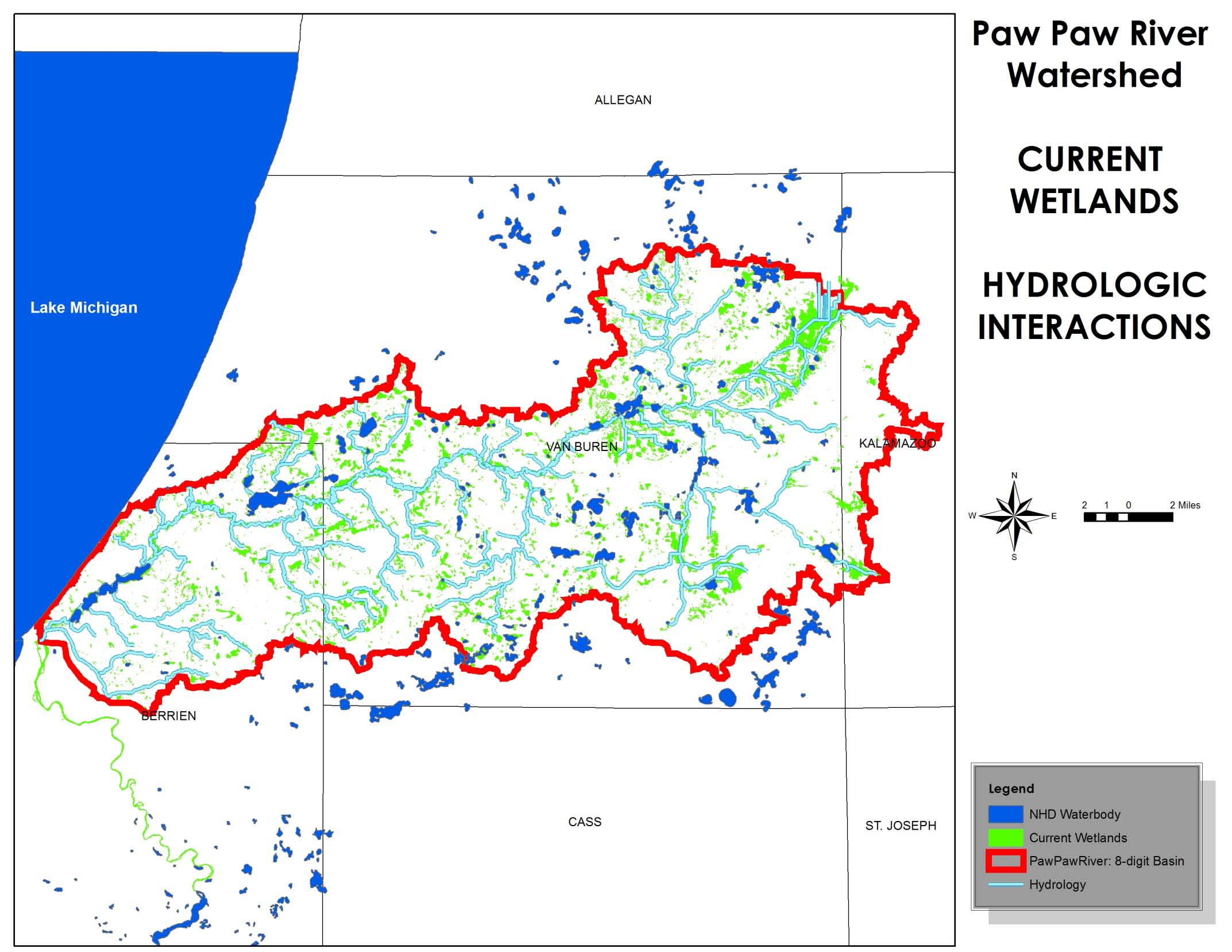
10 Non-Regulatory Programs Level 1: Landscape Level Assessment/ NWI Enhancement and Functional Assessment 2 WATERSHEDS APPROACHES Approach 1 -- Paw Paw River Watershed - Work done by LWMD staff in-house - Approximately 7500 wetlands to be classified Approach 2 -- River Raisin Watershed - Work done by watershed council staff with guidance from LWMD staff - Approximately 11,000 wetlands to be classified
, Digital Imagery, Topography, Soils, Geology 2.")

11 Non-Regulatory Programs Level 1: Landscape Level Assessment/ NWI Enhancement and Functional Assessment Determining LLWW Descriptors 1. Build a Geodatabase that encompasses spatial watershed data: Hydrology (NHD, State data), Digital Imagery, Topography, Soils, Geology 2. Based on NWI Code (Water Regime) and hydrological characteristics of a wetland, classify descriptors 3. Concatenate HGM Code for each wetland based on: Landform, Landscape Position, and Water Flow Path = Vegetated Wetlands Waterbody Type and Water Flow Path = Open Waterbodies 4. Connect HGM Code with Functional Correlations prepared by USFWS
12 Non-Regulatory Programs Landform Landscape Position Water Flow Path Waterbody Type Level 1: Landscape Level Assessment/ NWI Enhancement and Functional Assessment Slope Island Terrene Lentic Isolated Inflow Lake River EXAMPLE 1 -NWI Code = PF01C -H20 Regime = C or Seasonally Flooded LANDFORM = BASIN Fringe Floodplain Basin Flat Lotic River Lotic Stream Outflow Throughflow Bidirectional -Nontidal Pond Vegetated Wetland LANDSCAPE POSITION = TERRENE WATER FLOW PATH = ISOLATED WATERBODY TYPE = VEGETATED WETLAND HGM CODE = TEBAIS Example 2 CORRELATED FUNCTIONS = Surface Water Retention (High), Nutrient Transformation (High) Example 1

13 Non-Regulatory Programs Landform Landscape Position Water Flow Path Waterbody Type Level 1: Landscape Level Assessment/ NWI Enhancement and Functional Assessment Slope Island Terrene Lentic Isolated Inflow Lake River EXAMPLE 2 -NWI Code = PF02B -H20 Regime = B or Saturated LANDFORM = FLAT LANDSCAPE POSITION = TERRENE Fringe Floodplain Basin Flat Lotic River Lotic Stream Outflow Throughflow Bidirectional -Nontidal Pond Vegetated Wetland WATER FLOW PATH = OUTFLOW HEADWATER WATERBODY TYPE = VEGETATED WETLAND HGM CODE = TEFLOUhw CORRELATED FUNCTIONS = Surface Water Detention (Moderate), Streamflow Maintenance (High) Example 1 Example 2
14 Surface Water Detention (flooding mitigation) High Potential Fringe Wetlands Basin Wetlands Floodplain Wetlands Throughflow Ponds (in-stream) Moderate Potential Flats Interfluves Other Ponds (except sewage treatment ponds and similar waterbodies)
15 Streamflow Maintenance High Potential Nonditched Headwater Wetlands (hw) 1 st order perennial streams and above 2 nd order perennial streams in mountainous/hilly regions Moderate Potential Ditched Headwater Wetlands (hw + NWI d wetland) Lotic Floodplain Wetlands Throughflow Ponds and Lakes* (PUB on NWI) and associated wetlands Outflow Ponds and Lakes* (PUB on NWI) Terrene Outflow Wetlands (adjacent to streams) *Probably need to change NWI code
16 Nutrient Transformation High Potential Seasonally Flooded or wetter Vegetated NWI Wetlands and Tidal Equivalents (N, P, R, T, L) Permanently Saturated Vegetated Wetlands (bogs) Moderate Potential Seasonally Saturated and Temporarily Flooded Vegetated Wetlands and Tidal Equivalent (S)
17 Retention of Sediments and Other Particulates High Potential Vegetated Wetlands (wetter water regimes) Basin, Fringe (exc. Rocky Shore), Island, Floodplain Wetlands Lotic Basin Throughflow and Bidirectional Ponds and Lakes (PUB on NWI) and associated vegetated wetlands Terrene Throughflow Basin Wetlands Moderate Potential Nonvegetated Wetlands Vegetated Flat Wetlands (excluding bogs) Some others
18 Shoreline Stabilization High Potential Vegetated (except island types) along waterbodies Estuarine, Lotic, and Lentic Marine/Estuarine Rocky Shore (except islands) Moderate Potential Terrene Vegetated Wetlands along Ponds
19 Provision of Fish and Shellfish High Potential Habitat Estuarine Emergent, Unconsolidated Shore, Intertidal Reef, Aquatic Bed, and Rocky Shore (plus similar Marine, Riverinetidal, and Pal-tidal Wetlands excluding S water regime and EM5 = Phrag) (Add certain mangroves E2SS3 and E2FO3 Southeast) Lacustrine Semipermanently Flooded, Littoral Aquatic Bed, Unconsolidated Bottom/Vegetated Wetland, Permanently Flooded and Vegetated (add L2UBH) Palustrine Semi-permanent (contiguous with permanent waterbody) and associated ponds, Palustrine Unconsolidated Bottom/Vegetated
20 Fish and Shellfish (cont d) Moderate Potential E2FO and E2SS mixed with EM Palustrine Tidal FO and SS mixed with EM and having R or T water regime Lentic PEMIE Wetlands including mixes with FO and SS (Northeast) Other Ponds with Fringe Wetlands Excludes industrial, stormwater, and similar ponds in highly disturbed landscapes and ponds with K or F water regimes
21 Provision of Waterfowl and Waterbird Habitat High Potential Similar to Fish Habitat Includes PEM1E along streams (probably marshes) Beaver Ponds and associated wetlands Ponds associated with P F wetlands Wood Duck Potential Lotic Wetlands that are FO and SS with C and wetter water regimes Some others
22 Waterfowl and Waterbird Moderate Potential Habitat Seasonally flooded and wetter Phragmites wetlands E2EM5 and contiguous with waterbody PFO/EM1R and other tidal wetlands where EM is subordinate Lacustrine Littoral Unconsolidated Bottom Other Ponds (excluding industrial, commercial, stormwater, sewage treatment and similar ponds) PEM wetllands (including mixes with SS) that are Seasonally Flooded and wetter and associated with a waterbody
23 Provision of Other Wildlife High Potential Habitat Large vegetated wetlands > 20 acres (excluding open water, nonvegetated wetlands, and pine plantations) Small diverse wetlands (10-20 acres with 2 or more covertypes, excluding Phrag and open water types) Areas with large number of small isolated wetlands (including small ponds that may be vernal pools) Moderate Potential Other vegetated wetlands
24 Conservation of Biodiversity Unique types for the watershed Wetland types recognized as important or scarce regionally Riverine tidal emergent wetlands Palustrine tidal emergent wetlands Palustrine tidal scrub-shrub wetlands Urban wetlands Calcareous fens Lotic Fringe wetlands Headwater seep wetlands? Forested wetlands in forest complexes >7410 acres Shrub bogs Lentic fringe wetlands (EM/AB and AB/EM)
25 Non-Regulatory Programs Level 1: Landscape Level Assessment/ NWI Enhancement and Functional Assessment PRACTICAL USES OF ENHANCED NWI: Uses Depend on the Watershed: Urban Environment---Surface Water Retention Agricultural Environment---Nutrient Transformation Across the Board: Identifying Headwaters Targeting Areas for further assessment/ protection Mitigation Banks Wetland restoration opportunities WHAT IT WILL NOT DO: Guide regulatory decisions
26 Pre-settlement vs Paw Paw River Watershed Pre-settlement 82,503 acres 5,824 wetlands (could change) Average Size acres ,270 acres 7,581 wetlands Average Size acres
27
28
29
30
31
32

33
34
35
Michigan Wetlands. Department of Environmental Quality
 Department of Environmental Quality Wetlands are a significant component of Michigan s landscape, covering roughly 5.5 million acres, or 15 percent of the land area of the state. This represents about
4.2 Buena Vista Creek Watershed
 Buena Vista Creek Watershed 4.2 Buena Vista Creek Watershed Watershed Overview The Buena Vista Creek Watershed is the fourth-largest system within the Carlsbad Hydrologic Unit. The watershed extends approximately
DECISION DOCUMENT NATIONWIDE PERMIT 27
 DECISION DOCUMENT NATIONWIDE PERMIT 27 This document discusses the factors considered by the Corps of Engineers (Corps) during the issuance process for this Nationwide Permit (NWP). This document contains:
MINIMUM STANDARDS FOR ACCEPTANCE OF AQUATIC RESOURCES DELINEATION REPORTS
 MINIMUM STANDARDS FOR ACCEPTANCE OF AQUATIC RESOURCES DELINEATION REPORTS U.S. ARMY CORPS OF ENGINEERS BUILDING STRONG January 2016 The U.S Army Corps of Engineers, through its Regulatory Program, regulates
Recognizing Wetlands. For additional information contact your local U.S. Army Corps of Engineers office. Pitcher plant.
 US Army Corps of Engineers For additional information contact your local U.S. Army Corps of Engineers office. 1998 Edition Recognizing Wetlands Pitcher plant The information presented here will help you
Floodplain Connectivity in Restoration Design
 Floodplain Connectivity in Restoration Design 2015 Symposium on Restoration in a Contaminated Environment: Lessons Learned and Challenges in Moving Forward Part II April 2015 Karin Boyd Applied Geomorphology,
Basic Information Sheet: Depressional Wetlands
 Basic Information Sheet: Depressional Wetlands Assessment Area Name: Project Name: Assessment Area ID #: Project ID #: Date: Assessment Team Members for This AA AA Category: Pre-Restoration Post-Restoration
1.7.0 Floodplain Modification Criteria
 1.7.0 Floodplain Modification Criteria 1.7.1 Introduction These guidelines set out standards for evaluating and processing proposed modifications of the 100- year floodplain with the following objectives:
Restoration Planning and Development of a Restoration Bank
 Restoration Planning and Development of a Restoration Bank Black Creek Pioneer Village, South Theatre 8:30 a.m. to 3:30 p.m. Habitat Restoration and Environmental Monitoring Projects Section Restoration
33 CFR PART 332 COMPENSATORY MITIGATION FOR LOSSES OF AQUATIC RESOURCES. Authority: 33 U.S.C. 401 et seq. ; 33 U.S.C. 1344; and Pub. L. 108 136.
 33 CFR PART 332 COMPENSATORY MITIGATION FOR LOSSES OF AQUATIC RESOURCES Authority: 33 U.S.C. 401 et seq. ; 33 U.S.C. 1344; and Pub. L. 108 136. Source: 73 FR 19670, Apr. 10, 2008, unless otherwise noted.
Linking Wetland Alteration to Coastal Flooding: predictors, consequences, and policy implications
 Linking Wetland Alteration to Coastal Flooding: predictors, consequences, and policy implications Samuel D. Brody Sammy Zahran, Wesley Highfield, & Himanshu Grover Environmental Planning & Sustainability
MULTI-AGENCY COMPENSATORY MITIGATION PLAN CHECKLIST 1
 MULTI-AGENCY COMPENSATORY MITIGATION PLAN CHECKLIST 1 Mitigation Goals and Objectives o Describe functions lost at impact site o Describe functions to be gained at mitigation site o Describe overall watershed
RIPARIAN AREA MANAGEMENT
 RIPARIAN AREA MANAGEMENT TR 1737-16 1999, Revised 2003 AUser Guide to Assessing Proper Functioning Condition and the Supporting Science for Lentic Areas U.S. Department of the Interior Bureau of Land Management
a. For all activities that would result in the discharge of fill material into any vernal pool;
 Final Sacramento District Nationwide Permit Regional Conditions for Nevada and the Lake Tahoe Basin in California (Effective March 19, 2012 until March 18, 2017) 1.* When pre-construction notification
Background on Wetlands and Restoration. Information on Project Planning, Implementation, and Monitoring
 A GUIDE FOR THE PUBLIC CONTAINING: A N I N T R O D U C T I O N A N D U S E R S G U I D E T O Background on Wetlands and Restoration Information on Project Planning, Implementation, and Monitoring List
Rhode Island NRCS received approximately $2.4 million in ARRA funds to implement four floodplain easement projects.
 American Recovery and Reinvestment Act (ARRA) Emergency Watershed Protection Program Floodplain Easements Rhode Island Natural Resources Conservation Service Rhode Island NRCS received approximately $2.4
3. The submittal shall include a proposed scope of work to confirm the provided project description;
 QIN Shoreline Master Program Project Summary The Shoreline Master Program (SMP) development process for the Quinault Indian Nation (QIN) includes the completion of inventory and analysis report with corresponding
QUESTIONS AND ANSWERS WATERS OF THE U.S. PROPOSAL
 QUESTIONS AND ANSWERS WATERS OF THE U.S. PROPOSAL Key Background Congress enacted the modern Clean Water Act in 1972 to address pollution entering the nation s waters to complement statutes such as the
Restoring Ecosystems. Ecosystem Restoration Services
 Restoring Ecosystems Ecosystem Restoration Services 2 Ecosystem Restoration Services AECOM s integrated approach sciencebased planning, with innovative design and execution delivers sustainable and cost-effective
Classification of Wetlands and Deepwater Habitats of the United States
 Second Edition of the United States Adapted from Cowardin, Carter, Golet and LaRoe (1979) Wetlands Subcommittee Federal Geographic Data Committee August 2013 Established by Office of Management and Budget
13. ENVIRONMENTAL PROTECTION/ RESOURCE MANAGEMENT
 13. ENVIRONMENTAL PROTECTION/ RESOURCE MANAGEMENT A. Existing Conditions Ramsey is fortunate to have an ample amount of natural resources and open space areas and a community attitude that is increasingly
Remaining Wetland Acreage 1,500,000 915,960 584,040-39%
 NEW JERSEY Original Wetland Acreage Remaining Wetland Acreage Acreage Lost % Lost 1,500,000 915,960 584,040-39% New Jersey Wetlands: Nearly 99 percent of New Jersey s wetlands are palustrine or estuarine.
Using an All lands Framework for Conservation of Ecosystem Services
 Using an All lands Framework for Conservation of Ecosystem Services Robert Deal USDA Forest Service - PNW Research Station, Portland, OR Nikola Smith USDA Forest Service - Pacific Northwest Region, Portland,
Muddy River Restoration Project Project Description
 Muddy River Restoration Project Project Description Since the fall of 1996, the Muddy River has flooded three times, causing damage to residents, businesses institutions and the public transit system in
Wetlands in MN: Resource, Regulation, Restoration
 in MN: Resource, Regulation, Restoration Ben Meyer, Wetland Specialist Hennepin County Natural Resources Partnership January 27, 2015 What is a wetland? Definition (Federal Register): Those areas inundated
Regulatory Features of All Coastal and Inland Ecological Restoration Limited Projects
 Eligibility Checklist This Ecological Restoration Limited Project Eligibility Checklist guides the applicant in determining if their project is eligible to file as an Inland or Coastal Ecological Restoration
San Francisco Bay Area Wetlands Restoration Program Design Review Group. Project Summary Outline
 San Francisco Bay Area Wetlands Restoration Program Design Review Group Project Summary Outline The project proponent desiring to have a project considered by the Design Review Group (DRG) shall provide
Chesapeake Bay Preservation Area (CBPA) in Virginia Beach, Virginia. The Resource Protection Area (RPA) and Buffers The First 100 Feet
 in Virginia Beach, Virginia. The Resource Protection Area (RPA) and Buffers The First 100 Feet") Chesapeake Bay Preservation Area (CBPA) in Virginia Beach, Virginia The Resource Protection Area (RPA) and Buffers The First 100 Feet How Large is the Chesapeake Bay Watershed? The Chesapeake Bay Watershed
Chesapeake Bay Preservation Area (CBPA) in Virginia Beach, Virginia The Resource Protection Area (RPA) and Buffers The First 100 Feet How Large is the Chesapeake Bay Watershed? The Chesapeake Bay Watershed
Curt Kerns, M.S., R.P.Bio., C.F.S. WetlandsPacific Corp. 250-722-7117 www.wetlandspacific.com
 Curt Kerns, M.S., R.P.Bio., C.F.S. WetlandsPacific Corp. 250-722-7117 www.wetlandspacific.com Presentation Historical perspectives Present perspectives How wetlands function Examples of natural wetlands
LEAGUE NOTES ON APPROVED COMMUNITY WATER SUPPLY PLAN
 1 AUGUST 2011 LEAGUE NOTES ON APPROVED COMMUNITY WATER SUPPLY PLAN KEY ELEMENTS OF THE PLAN: 1. Replace the existing unsafe Ragged Mountain dam with a new dam and raise the reservoir pool level initially
Town of Elkton & Cecil Soil Conservation District Checklist for Joint Agency Review Stormwater Management / Erosion and Sediment Control
 Town of Elkton & Cecil Soil Conservation District Checklist for Joint Agency Review Stormwater Management / Erosion and Sediment Control Project Name: Tax Map Parcel: Acreage: Plat: ADC Map & Grid Engineering
A Developer s Guide: Watershed-Wise Development
 A Developer s Guide: Watershed-Wise Development Environmental Protection What is a watershed? It does not matter how far away you build from a creek, lake, or the ocean, you are in a watershed. Another
Aquatic Biomes, Continued
 Aquatic Biomes, Continued Introduction Extent of Marine biomes Issues & challenges Factors influencing distribution Dynamics in time & space Depth Tour of marine biomes Issues (by biome) Freshwater biomes
STORMWATER MANAGEMENT CHECKLIST
 STORMWATER MANAGEMENT CHECKLIST *This checklist must be completed and part of the Land Disturbing Permit submittal for review if the acreage disturbed is one (1) acre or more: I. SUPPORTING DATA Narrative
Comprehensive Wetland Program Plan Commonwealth of Virginia 2011-2015
 Comprehensive Wetland Program Plan Commonwealth of Virginia 2011-2015 Submitted By: Virginia Department of Environmental Quality 629 East Main Street Richmond, Virginia 23219 In Collaboration with: Virginia
WHAT ABOUT WREGULATIONS? CHAPTER 7. 1.
 chapter 7. what about regulations? CHAPTER 7. 1. Thomas W. Ford WHAT ABOUT Deanne D. Wilde WREGULATIONS? hen proposing a wetland restoration project there are various federal and state laws, along with
Detention Ponds. Detention Ponds. Detention Ponds. Detention Ponds. Detention Ponds. Detention Ponds. CIVL 1112 Detention Ponds - Part 1 1/12
 CIVL 1112 - Part 1 1/12 The water cycle, also known as the hydrologic cycle, describes the continuous movement of water on, above and below the surface of the Earth. The water cycle, also known as the
Snapshots: Resilient Lands and Waters Initiative
 Snapshots: Resilient Lands and Waters Initiative Introduction... 2 Lakes Huron and Erie Coastal Wetlands (Saginaw Bay (MI) to Maumee River (OH/IN))... 3 Puget Sound/Snohomish River Watershed... 4 Southwest
ANGORA FIRE RESTORATION PROJECT
 ANGORA FIRE RESTORATION PROJECT U.S. Forest Service LAKE TAHOE BASIN MANAGEMENT UNIT Duncan Leao Vegetation Management Planner Richard Vacirca Forest Aquatics Biologist 3 PHASES OF FIRE REHAB Phase I Rehab:
Chapter 3 SENSITIVE AREAS AND VEGETATED CORRIDORS
 Chapter 3 3.01 General Provisions 3.01.1 Introduction 3.01.2 Application and Interpretation of Chapter 3.01.3 Unbuildable Lots 3.01.4 Other Permits 3.01.5 Prohibited Activities 3.02 Service Provider Letter
Interim Technical Guidelines for the Development of Environmental Management Plans for Underground Infrastructure Revised - July 2013.
 Interim Technical Guidelines for the Development of Environmental Management Plans for Underground Infrastructure Revised - July 2013 Rationale Underground infrastructure may be at risk from valley, streambank
GLOSSARY OF TERMS CHAPTER 11 WORD DEFINITION SOURCE. Leopold
 CHAPTER 11 GLOSSARY OF TERMS Active Channel The channel that contains the discharge Leopold where channel maintenance is most effective, sediment are actively transported and deposited, and that are capable
Subsidence Mitigation Through Rice Cultivation Research Project Goals:
 Twitchell Island rice growing area Subsidence Mitigation Through Rice Cultivation Research 1. Determine the viability of different rice growing methods within the Delta. 2. Determine the rates/amounts
Resource Management Accomplishments FY 2014
 Resource Management Accomplishments FY 2014 Sea turtle nest protection - Over 3,700 sea turtle nests were covered with wire mesh screens to protect them from being predated. Data on each sea turtle activity
Henry Van Offelen Natural Resource Scientist MN Center for Environmental Advocacy hvanoffelen@mncenter.org
 Henry Van Offelen Natural Resource Scientist MN Center for Environmental Advocacy hvanoffelen@mncenter.org Wetland study slide Water Quality NRE goals in watershed plans Protect habitat that remains.
U.S. Fish & Wildlife Service. National Wetlands Inventory: A Strategy for the 21 st Century
 U.S. Fish & Wildlife Service National Wetlands Inventory: A Strategy for the 21 st Century Estuarine emergent wetlands account for only five percent of the wetland area in the lower 48 States. Those like
Summary of the 2012 Nationwide Permits
 Summary of the 2012 Nationwide Permits Nationwide Permit NWP 1 Aids to Navigation 10 PCN not required NWP 2 Structures in 10 PCN not required Artificial Canals NWP 3 Maintenance 10/404 Does not authorize:
Appendix J Online Questionnaire
 Appendix J Online Questionnaire In accordance with the Paperwork Reduction Act, this questionnaire was approved by the Office of Management and Budget (OMB). The OMB control number and expiration date
Applying HUD s Floodplain Management and Wetlands Protection Standards U.S. Department of Housing and Urban Development Office of Environment and
 Applying HUD s Floodplain Management and Wetlands Protection Standards U.S. Department of Housing and Urban Development Office of Environment and Energy Executive Order 11988 Floodplain Management Training
Summary of the Proposed 2017 Nationwide Permits 1
 Summary of the Proposed 2017 Nationwide Permits 1 Nationwide Permit NWP 1 Aids to Navigation 10 none PCN not no navigable waters of the U.S. none NWP 2 Structures in 10 none PCN not no navigable waters
Calculating Credits and Debits for Compensatory Mitigation in Wetlands of Western Washington
 Calculating Credits and Debits for Compensatory Mitigation in Wetlands of Western Washington Final Report March 2012 Publication #10-06-011 This page is left blank on purpose Calculating Credits and Debits
Miquon Creek STREAM RESTORATION PROJECT WHO WE ARE
 Miquon Creek STREAM RESTORATION PROJECT WHO WE ARE Introductions Brett Long, PE Project Permitting & Construction Oversight Chris Streb, PE Project Designer & Construction Oversight Assistance WHO WE ARE
Integrated Restoration Prioritization
 Integrated Restoration Prioritization Habitat Restoration and Environmental Monitoring Projects Section Restoration Services Division Definition Restoration Prioritization is a process of combining various
Liquid Capital. Cochran s Creek: A Case Study in Stream Mitigation Banking in Georgia
 Liquid Capital Cochran s Creek: A Case Study in Stream Mitigation Banking in Georgia Basic Bank Permitting Process Submit Prospectus to IRT. If approved then: Conduct site visit with IRT. If approved then:
HCP Team Meeting. November 18, 2015. icfi.com
 HCP Team Meeting November 18, 2015 icfi.com 1 Welcome and Introductions Where are we in the HCP process Hydrology modeling update Native fish survey Fish translocation Finalize covered activities Next
Flood Risk Management
 Flood Risk Management Value of Flood Risk Management Every year floods sweep through communities across the United States taking lives, destroying property, shutting down businesses, harming the environment
Flood Risk Management
 Flood Risk Management Value of Flood Risk Management Value to Individuals and Communities Every year floods sweep through communities across the United States taking lives, destroying property, shutting
Prioritizing Riparian Restoration at the Watershed, Reach and Site Scales. Richard R. Harris University of California, Berkeley Cooperative Extension
 Prioritizing Riparian Restoration at the Watershed, Reach and Site Scales Richard R. Harris University of California, Berkeley Cooperative Extension Issues Riparian communities provide multiple benefits
Prepared By: Tom Parker Geum Environmental Consulting, Inc.
 Prepared By: Tom Parker Geum Environmental Consulting, Inc. Topics covered: Definition of riparian and floodplain restoration Floodplain attributes as a basis for developing criteria for restoration designs
MAINE SHORELAND ZONING
 MAINE SHORELAND ZONING A HANDBOOK FOR SHORELAND OWNERS Maine Department of Environmental Protection Spring, 2008 Publication Number: DEPLW0674-D08 TABLE OF CONTENTS ACKNOWLEDGMENTS II THE PURPOSE OF THIS
Briefing Paper on Lower Galveston Bay and Bayou Watersheds Lower Bay I: Armand Bayou to Moses Lake and Adjacent Bay Waters
 Briefing Paper on Lower Galveston Bay and Bayou Watersheds Lower Bay I: Armand Bayou to Moses Lake and Adjacent Bay Waters Jim Lester, PhD. and Lisa Gonzalez Houston Advanced Research Center Galveston
SITE DEVELOPMENT PLAN CHECKLIST. Project Name: Site Plan No.:
 SITE DEVELOPMENT PLAN CHECKLIST 5/12/05 Rev.3/14/06 Project Name: Site Plan No.: REVIEW CRITERIA Plans: A site development plan (signed and sealed) shall be on a 24 x 36 sheet at a scale that is no smaller
OVERVIEW MIDDLE CREEK FLOOD DAMAGE REDUCTION AND ECOSYSTEM RESTORATION PROJECT October 3, 2012 INTRODUCTION
 OVERVIEW MIDDLE CREEK FLOOD DAMAGE REDUCTION AND ECOSYSTEM RESTORATION PROJECT October 3, 2012 INTRODUCTION The Middle Creek Flood Damage Reduction and Ecosystem Restoration Project (Project) will eliminate
CITY UTILITIES DESIGN STANDARDS MANUAL
 CITY UTILITIES DESIGN STANDARDS MANUAL Book 2 (SW) SW9 June 2015 SW9.01 Purpose This Chapter provides information for the design of open channels for the conveyance of stormwater in the City of Fort Wayne.
Bringing Covert Land Use Strategies into the Spotlight: Cracking the Code for Sustainable Coastal Communities
 Bringing Covert Land Use Strategies into the Spotlight: Cracking the Code for Sustainable Coastal Communities Dan Hitchcock Baruch Institute, Clemson University, Georgetown, SC NEMO U 007 Portland, Maine
Ecosystem Services, Wetlands and Houston s Growth. Jim Lester
 Ecosystem Services, Wetlands and Houston s Growth Jim Lester Definitions (MEA 2005) Ecosystem: a dynamic complex of plant, animal, and microorganism communities and the nonliving environment interacting
401 Water Quality Certification and Isolated Wetlands Permitting in Ohio. Tom Harcarik Division of Surface Water
 401 Water Quality Certification and Isolated Wetlands Permitting in Ohio Tom Harcarik Division of Surface Water Session Overview Part I: Why this is Important Part II: Brief Overview of Laws and Rules
Development of a Statewide Freshwater Wetland Restoration Strategy
 Development of a Statewide Freshwater Wetland Restoration Strategy Site Identification and Prioritization Methods Nicholas A. Miller and Francis C. Golet Department of Natural Resources Science University
How To Study Wetland Trends In Florida
 Great Egret W METZEN THE AUTHORS W. E. Frayer is Dean of the School offorestry and Wood Products at Michigan Technological University. He specializes in natural resources survey design and analysis. J.
DRAFT ENVIRONMENTAL ASSESSMENT TEMPLATE
 DRAFT ENVIRONMENTAL ASSESSMENT TEMPLATE I. SUMMARY A. PROJECT IDENTIFICATION Applicant: Address: Project No. B. CONTACT PERSON Mr.\Ms. City or County Manager P.O. Box, Colorado 80 C. ABSTRACT Briefly summarize
Ouachita River Floodplain Restoration Upper Ouachita NWR, Louisiana
 Ouachita River Floodplain Restoration Upper Ouachita NWR, Louisiana Interior Hydrologic Restoration Plan Mollicy Farms Unit The Nature Conservancy Louisiana Field Office 2011 Cover: Sediment laden water
COMPREHENSIVE PLAN SECTION B, ELEMENT 4 WATER RESOURCES. April 20, 2010 EXHIBIT 1
 COMPREHENSIVE PLAN SECTION B, ELEMENT 4 WATER RESOURCES April 20, 2010 EXHIBIT 1 ELEMENT 4 WATER RESOURCES TABLE OF CONTENTS 4.1 INTRODUCTION 4.2 GOALS AND POLICIES 4.2.A General Goals and Policies 1 4.2.B
A. General Information
 Important: When filling out forms on the computer, use only the tab key to move your cursor - do not use the return key. Massachusetts Department of Environmental Protection WPA Form 3 Notice of Intent
REFERENCE. All National Grid personnel who plan and perform work involving protected water resources are responsible for:
 EG-30NY ENVIRONMENTAL GUIDANCE PAGE 1 of 9 DATE 10/1/10 EP 3 Natural Resource Protection 1.0 SCOPE AND RESPONSIBILITIES National Grid s New York service territory encompasses thousands of wetlands, lakes,
The project site lies within an AE Zone and portions lie within the regulated floodway. Development of this site is subject to TCLUO, Section 3.060.
 Introduction This application is for the Southern Flow Corridor-Landowner Preferred Alternative, a flood mitigation and tidal wetland restoration project. The Port of Tillamook Bay is the applicant in
Appendix A. Lists of Accomplishments and Project Costs. UMRWD 10 Year Plan Update. Appendix A UPPER MINNESOTA RIVER WATERSHED DISTRICT
 UPPER MINNESOTA RIVER WATERSHED DISTRICT Lists of Accomplishments and Project Costs 10 Year Plan Update UMRWD 10 Year Plan Update Page A 1 UMRWD LIST OF ACCOMPLISHMENTS Since its inception in 1967, the
General Permit for Activities Promoting Waterway - Floodplain Connectivity [working title]
![General Permit for Activities Promoting Waterway - Floodplain Connectivity [working title]](/thumbs/39/18645965.jpg "General Permit for Activities Promoting Waterway - Floodplain Connectivity [working title]") General Permit for Activities Promoting Waterway - Floodplain Connectivity [working title] Purpose These rules set forth the conditions under which a person may, without an individual removal-fill permit
General Permit for Activities Promoting Waterway - Floodplain Connectivity [working title] Purpose These rules set forth the conditions under which a person may, without an individual removal-fill permit
1 st Edition, December 2011
 Oregon Wetland Program Plan 2011 2016 1 st Edition, December 2011 Prepared by the Oregon Department of State Lands Wetlands & Waterways Conservation Division Pursuant to the Environmental Protection Agency
Coastal Engineering Indices to Inform Regional Management
 Coastal Engineering Indices to Inform Regional Management Lauren Dunkin FSBPA 14 February 2013 Outline Program overview Standard products Coastal Engineering Index Conclusion and future work US Army Corps
Direct and Indirect Impacts of Urbanization on Wetland Quality
 W E T L A N D S & W A T E R S H E D S Direct and Indirect Impacts of Urbanization on Wetland Quality DECEMBER 2006 1 Direct and Indirect Impacts of Urbanization on Wetland Quality Wetlands & Watersheds
Vernal Pools: Introduction. Massachusetts state regulations that provide vernal pool protection
 Vernal Pools: Regulatory Protection in Massachusetts Introduction The importance of vernal pool habitat has been recognized in Massachusetts for over 2 decades. Salamander surveys conducted in the early
Earth Science. River Systems and Landforms GEOGRAPHY 1710. The Hydrologic Cycle. Introduction. Running Water. Chapter 14.
 Earth Science GEOGRAPHY 1710 River Systems and Landforms DAVID R. SALLEE Robert W. Christopherson Charlie Thomsen Chapter 14 Introduction Rivers and streams are dynamic systems that continually adjust
ERP: Willamette-Ecosystem Services Project
 ERP: Willamette-Ecosystem Services Project Presented by Iris Goodman to NAS Sustainability R&D Forum October 17-18, 2007 Conserving ecosystem services through proactive decision-making making Linking Human
AN INITIATIVE TO IMPROVE
 L OW E R C A R M E L R I V E R A N D L AG O O N F L O O D P L A I N R E S TO R AT I O N A N D E N H A N C E M E N T P R O J E C T AN INITIATIVE TO IMPROVE FLOOD PROTECTION RESTORE AND PROTECT RIPARIAN
The Basics of Chapter 105 Waterways and Wetlands Permitting in PA
 The Basics of Chapter 105 Waterways and Wetlands Permitting in PA April 17, 2013 Goal To develop a basic understanding of PA Department of Environmental Protection (DEP) and US Army Corps of Engineers
2008 Compensatory Mitigation Rule: Overview and Highlights. Jenny Thomas U.S. Environmental Protection Agency Wetlands Division July 2014
 2008 Compensatory Mitigation Rule: Overview and Highlights Jenny Thomas U.S. Environmental Protection Agency Wetlands Division July 2014 Outline Background Rule goals Rule structure 8 sections Highlight
How To Plan A Buffer Zone
 Backyard Buffers Protecting Habitat and Water Quality What is a buffer? A buffer (also called a riparian buffer area or zone) is the strip of natural vegetation along the bank of a stream, lake or other
Backyard Buffers that Work for People and Nature by Restoring Ecological Function
 Backyard Buffers that Work for People and Nature by Restoring Ecological Function What is a Wetland Buffer? A wetland buffer is a simple land management practice that is employed by municipalities to protect
STANDARDS FOR RANGELAND HEALTH ASSESSMENT FOR SAGEHEN ALLOTMENT #0208
 STANDARDS FOR RANGELAND HEALTH ASSESSMENT FOR SAGEHEN ALLOTMENT #0208 RANGELAND HEALTH STANDARDS - ASSESSMENT SAGEHEN ALLOTMENT #0208 STANDARD 1 - UPLAND WATERSHED This standard is being met on the allotment.
EFB 496.10/696.03 Online Wetland Restoration Techniques Class Syllabus
 EFB 496.10/696.03 Wetland Restoration Techniques Online Class Syllabus SUNY-ESF College of Environmental Science and Forestry Summer Session II 2015 Wetland Restoration Techniques is a graduate and undergraduate
San Francisco Bay Margin Conservation Decision Support System (DSS)
") San Francisco Bay Margin Conservation Decision Support System (DSS) Presented by Brian Fulfrost1, MS David Thomson2, MS 1 Brian Fulfrost and Associates 2 San Francisco Bay Bird Observatory Transitional
San Francisco Bay Margin Conservation Decision Support System (DSS) Presented by Brian Fulfrost1, MS David Thomson2, MS 1 Brian Fulfrost and Associates 2 San Francisco Bay Bird Observatory Transitional
Land Disturbance, Erosion Control and Stormwater Management Checklist. Walworth County Land Conservation Department
 Land Disturbance, Erosion Control and Stormwater Management Checklist Walworth County Land Conservation Department The following checklist is designed to assist the applicant in complying with the Walworth
Communities, Biomes, and Ecosystems
 Communities, Biomes, and Ecosystems Before You Read Before you read the chapter, respond to these statements. 1. Write an A if you agree with the statement. 2. Write a D if you disagree with the statement.
Series 2016A-2 (Green Bonds) Final Proceeds Allocation April 2016
 Final Proceeds Allocation April 2016") Series 2016A-2 (Green Bonds) Final Proceeds Allocation April 2016 James L. McIntire Washington State Treasurer Summary The State of Washington offered green bonds to investors in September 2015, with approximately
Series 2016A-2 (Green Bonds) Final Proceeds Allocation April 2016 James L. McIntire Washington State Treasurer Summary The State of Washington offered green bonds to investors in September 2015, with approximately
MAPPING MINNEAPOLIS URBAN TREE CANOPY. Why is Tree Canopy Important? Project Background. Mapping Minneapolis Urban Tree Canopy.
 MAPPING MINNEAPOLIS URBAN TREE CANOPY Why is Tree Canopy Important? Trees are an important component of urban environments. In addition to their aesthetic value, trees have significant economic and environmental
Vineyard Site Assessment Guide
 Vineyard Site Assessment Guide A primer for effective interaction with resource and regulatory agencies in Sonoma County University of California Cooperative Extension In accordance with applicable State
Sample DEQ Plan Submitter s Checklist for Stormwater Management Plans
 APPENDIX IV Version: February 2, 2015 Sample DEQ Plan Submitter s Checklist for Stormwater Management Plans Please fill in all blanks and please reference the plan sheets/pages where the information may
WORKSHOP SUMMARY REPORT 1
 Climate Change Vulnerability Assessment & Adaptation Strategies for Sierra Nevada Resources Sierra Nevada Workshop Series October 14-17, 2014 WORKSHOP SUMMARY REPORT 1 Photo: ESA 1 Authors: Jessi Kershner
Environmentally Significant Areas of Alberta. Volume 3. Prepared by: Sweetgrass Consultants Ltd. Calgary, AB. for:
 Environmentally Significant Areas of Alberta Volume 3 Prepared by: Calgary, AB for: Resource Data Division Alberta Environmental Protection Edmonton, Alberta March 1997 EXECUTIVE SUMMARY Large portions
Carlton Fields Memorandum
 Carlton Fields Memorandum TO: FROM: RE: DAN WEEDE FRED RUSHING RIPARIAN BUFFER DATE: JULY 26, 2013 BACKGROUND Both the state of Georgia and the city of Atlanta 1 have certain guidelines that must be followed