MAGNOLIA AVENUE SPECIFIC PLAN ADOPTED NOVEMBER 10, 2009 PER CITY COUNCIL RESOLUTION NO
|
|
|
- Avis Willis
- 8 years ago
- Views:
Transcription
1 MAGNOLIA AVENUE SPECIFIC PLAN ADOPTED NOVEMBER 10, 2009 PER CITY COUNCIL RESOLUTION NO

2

3 MAGNOLIA AVENUE SPECIFIC PLAN ACKNOWLEDGEMENTS Many people played a part in preparing this Specific Plan. The City wishes to give special acknowledgement to the contributions of individuals noted below, as well as countless others who provided support. MAYOR & CITY COUNCIL Ronald O. Loveridge, Mayor Mike Gardner, Ward 1 Andy Melendrez, Ward 2 William Rusty Bailey, Ward 3 Paul Davis, Ward 4 Chris MacArthur, Ward 5 Nancy Hart, Ward 6 Steve Adams, Ward 7 FORMER CITY COUNCIL Dom Betro, Ward 1 Art Gage, Ward 3 Frank Schiavone, Ward 4 Ed Adkison, Ward 5 PLANNING COMMISSION Finn Comer, Chairperson Tim Maloney, Vice Chairperson Patricia Lock-Dawson, Secretary Larry Allen, Sergeant at Arms William Allen, Commissioner Stan Brown, Commissioner Thomas Riggle, Commissioner Joseph Tavaglione, Commissioner Robert T. Wade, Commissioner November 2009

4 MAGNOLIA AVENUE SPECIFIC PLAN MAGNOLIA/MARKET SUBCOMMITTEE Randy Akes Manuel Carrasco Mike Conway Ian Davidson Bill Galloway Mark Howe Jerry Irwin Lorie Reitz Matt Webb In Remembrance of the late Subcommittee member Eric Solander CITY STAFF Ken Gutierrez, AICP, Planning Director Diane Jenkins, AICP, Principal Planner Doug Darnell, AICP, Senior Planner Patricia Brenes, Senior Planner David Murray, Senior Planner Moises Lopez, Associate Planner COMMUNITY DEVELOPMENT DEPARTMENT STAFF Dan Chudy, Building Official Sandy Gosselin, Senior Graphics Tech Erin Gettis, Historic Preservation Officer Paul DeRouen, Information Systems Support Matthew Keeling, GIS Analyst November 2009

5 MAGNOLIA AVENUE SPECIFIC PLAN OTHER CITY DEPARTMENTS Bradley J. Hudson, City Manager Belinda Graham, Assistant City Manager Kristi Smith, Supervising Deputy City Attorney Austin Carter, Public Information Officer Tom Boyd, Deputy Public Works Director/City Engineer Wendy Holland, Redevelopment Project Manager Larry Andersen, Senior Printing Services Operator SPECIFIC PLAN CONSULTANTS The Arroyo Group Planning and Urban Design Meyer, Mohaddes Associates, Inc., An Iteris Company Transportation Planning EPT Design Landscape Architecture P&D Consultants, Inc. Environmental Assessment Albert A. Webb Associates Environmental Assessment November 2009

6

7 CITY OF RIVERSIDE Acknowledgements TABLE OF CONTENTS Chapter 1 - Introduction A. What is a Specific Plans B. Specific Plan Area C. Background D. Purpose of the Specific Plan E. Community Participation F. Applicability and Conformity with the Specific Plan G. Relationship of the Specific Plan to the City s General Plan H. Relationship of the Specific Plan to the City s Zoning Code I. Relationship of the Specific Plan to the Redevelopment Project Areas Magnolia Avenue Specific Plan Chapter 2 - Context A. Historic Context B. Current Setting C. General Plan Designations Chapter 3 Vision, Objectives and Policies A. Corridor Wide Vision, Objectives and Policies Vision for Magnolia Avenue Corridor Wide Objectives and Policies B. La Sierra District District Context La Sierra District Objective and Policies General Plan 2025 Land Use Designations Framing the Vision C. Galleria District District Context Galleria District Objective and Policies General Plan 2025 Land Use Designations Framing the Vision D. Arlington District District Context Arlington District Objective and Policies General Plan 2025 Land Use Designations Framing the Vision E. Magnolia Heritage District District Context Magnolia Heritage District Objective and Policies General Plan 2025 Land Use Designations Framing the Vision F. Magnolia Center District District Context Magnolia Center District Objective and Policies General Plan 2025 Land Use Designations Framing the Vision G. Wood Streets District November 2009 i

8 CITY OF RIVERSIDE Magnolia Avenue Specific Plan District Context Wood Streets District Objective and Policies General Plan 2025 Land Use Designations Framing the Vision Chapter 4 Land Use Regulations, Development Standards and Design Guidelines A. Permitted Uses B. Prohibited Uses C. Development Standards D. Design Guidelines E. General Requirements ADDENDUM TO CHAPTER 4 ARLINGTON DESIGN GUIDELINES Chapter 5 - Circulation A. Current Transportation Setting B. Traffic Volumes C. Intersection Level-of-Service D. Future Traffic Operations along Magnolia Avenue E. Transit Services F. Bus Rapid Transit G. Bicycle Lanes H. Pedestrian Circulation I. Intersection at Magnolia/Brockton/Central Avenues J. Magnolia Undercrossing/Railroad Grade Separation Project K. Frontage Roads Chapter 6 Streetscape Improvements A. Current Streetscape Setting B. Streetscape Concept C. Landscape Palette D. Street Furnishings E. Public Art F. Utility Lines Chapter 7 Implementation A. How a Specific Plan Can Facilitate Private Economic Investment B. Land Use Potential and Mixed Use Designated Areas C. Recommended Implementation Strategies D. Financing Mechanisms E. General Phasing Strategy Appendix 1 Demographic and Market Conditions for Magnolia Avenue... A-1 Key Demographic Trends... A-3 Retail Market Factors... A-4 TABLES 1.1: Specific Plan Land Area (Gross Acres) : General Plan Land Use Designation by Acreage : General Plan Land Use Designations in the La Sierra District : General Plan Land Use Designations in the Galleria District ii November 2009

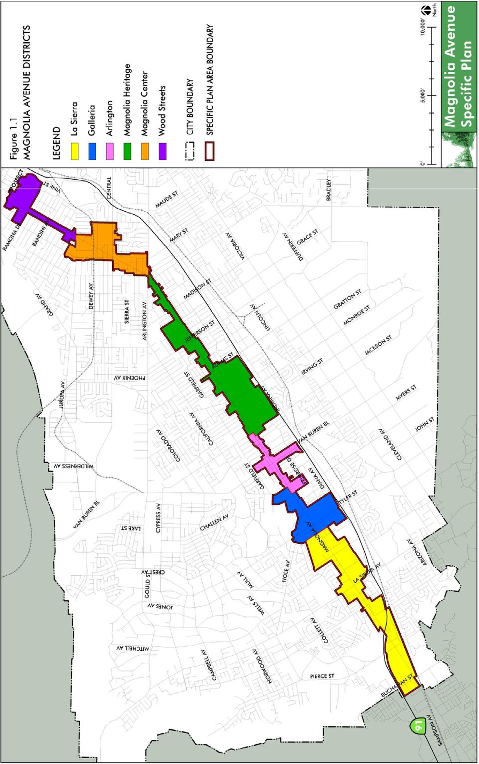
9 CITY OF RIVERSIDE 3.3: General Plan Land Use Designations in the Arlington District : General Plan land Use Designations in the Magnolia Heritage District : General Plan Land Use Designations in the Magnolia Center District : General Plan Land Use Designations in the Wood Streets District : Intersection Level of Service Definitions : Level-of-Service / Delay Summary : Magnolia Avenue Landscape Palette FIGURES 1.1: Magnolia Avenue Districts : Redevelopment Project Areas : Historic Landmarks & Districts : Community Facilities : La Sierra District : Conceptual Plan for the Magnolia Avenue/La Sierra Intersection Area : Galleria District : Conceptual Plan for the Magnolia Avenue/Tyler Street Intersection Area : Arlington District : Conceptual Plan for the Magnolia Avenue/Van Buren Boulevard Intersection Area : Magnolia Heritage District : Conceptual Plan for the Magnolia Avenue/Adams Street Intersection Area : Magnolia Center District : Conceptual Plan for the Magnolia/Center/Brockton Avenue Area : Wood Streets District : Conceptual Plan for the Magnolia Avenue/Jurupa Avenue Intersection Area : Magnolia/Van Buren Corridor Districts : Village Site Design Guidelines : Creating Pedestrian Scale for Larger Buildings : Portal Area Site Design Guidelines : Village Building Design Guidelines : Portal Area Building Design Guidelines : Typical Improved Village Rear Façade : Standard Shed Style Awning : Various Types of Awnings : Appropriate & Inappropriate Signs for the Village of Arlington : Perspective of Village Streetscape : Plan of Typical Sidewalk Layout in the Village : Elevation of Typical Sidewalk Scene in the Village : Cross-Section of Sidewalk in the Village : Details for Post Top Street Light : Street Furniture Parking Lot Entry Concept in the Village : Miller Street Parking Concept : Study Area : Existing Roadway Functional Classifications : 2003 Average Daily Traffic : Existing AM Turning Volumes : Existing PM Turning Volumes : Transit Services within Riverside : RapidLink Route 1-A with 14 Stations A: Roadway Cross-Sections with Potential Buildout Magnolia Avenue Specific Plan November 2009 iii

10 CITY OF RIVERSIDE Magnolia Avenue Specific Plan 5.8B: Roadway Cross-Sections with Potential Buildout C: Roadway Cross-Sections with Potential Buildout D: Roadway Cross-Sections with Potential Buildout E: Roadway Cross-Sections with Potential Buildout F: Roadway Cross-Sections with Potential Buildout A: La Sierra District Streetscape B La Sierra District Streetscape : Galleria District Streetscape : Arlington Village District Streetscape : Magnolia Heritage District Streetscape : Magnolia Center District Streetscape : Wood Streets District Streetscape iv November 2009

11 CHAPTER 1 Introduction

12

13 CHAPTER 1 A. What is a Specific Plan? A Specific Plan is a regulatory tool that local governments use to implement the General Plan and to guide development in a localized area. While the General Plan is the overall guide for growth and development in a community, a Specific Plan is able to focus on the unique characteristics of a special area by customizing the planning process and land use regulations to that area. A Specific Plan is enacted pursuant to Section et seq. of the California Government Code. Introduction B. Specific Plan Area Magnolia Avenue is one of the primary east/west streets in the City of Riverside. It extends from Downtown at Market Street to the east, to the western City boundary at Buchanan Street to the west. It continues into the City of Corona and ends at Ontario Avenue. This plan is focusing on the portion of Magnolia Avenue from the western City limits to the north side of Riverside Community College (RCC), at the southern edge of Downtown. The Market Street portion of the corridor is not included in this Plan because it is within the boundaries of the Downtown Specific Plan and is addressed therein. The project area consists of six Specific Plan Districts, which were created in 1999 as part of the Magnolia/Market Corridor Study (described on page 1-4). These districts, from southwest to northeast along the corridor, are: La Sierra (Buchanan Street to just east of Banbury Drive) Galleria (just east of Banbury Drive to Harrison Street) Arlington (Harrison Street to Jackson Street) Magnolia Heritage (Jackson Street to Arlington Avenue) Magnolia Center (Arlington Avenue to Jurupa Avenue) Wood Streets (Jurupa Avenue to north side of RCC) Figures 1.1 identifies the project and district boundaries. Table 1.1 identifies the size of the Specific Plan area and each district. Table 1.1: Specific Plan Land Area (Gross Acres) District Acreage La Sierra 457 Galleria 207 Arlington 106 Magnolia Heritage 461 Magnolia Center 147 Wood Streets 210 TOTAL 1,588 November

14 CITY OF RIVERSIDE Magnolia Avenue Specific Plan C. Background The Magnolia Avenue/Market Street corridor has been the subject of several past planning efforts, the most recent and relevant of which are discussed here: Magnolia Avenue, Planning Approaches and Strategies In 1996, a two-day charrette -type workshop was sponsored by the Local Government Commission on the revitalization of Magnolia Avenue. Meeting with representatives of all neighborhoods along the Magnolia/Market corridor, the group discussed issues and opportunities for improvement of the corridor. Following that meeting, a task force was appointed by the City Council to expand on the recommendations of the workshop. The task force prepared an action plan that focused on both immediate and long term goals for the improvement and restoration of Magnolia Avenue. The results were summarized in the report Magnolia Avenue, Planning Approached and Strategies (September 1996, upated January 1998). The next step of the process was to commission a more detailed study of the entire corridor that would set a framework for identifying, prioritizing, and coordinating all Magnolia Corridor planning work, both immediate and long range. The Magnolia/Market Corridor Study, described below, is the result of this further study under the criteria set up by the 1996 task force. Magnolia/Market Corridor Study In 1999, the architecture and design firm Moule & Polyzoides prepared the Magnolia/Market Corridor Study, a comprehensive report which presents recommendations about land use, economic development, traffic, parking, transit, building types, open space, landscape, historic preservation, building codes and catalytic projects for the corridor. This study was prepared with extensive public input and a Citizen s Advisory Committee. While never formally adopted and not a regulatory document, this study contains many recommendations that are still valid for the corridor, which are therefore incorporated into this Specific Plan. Downtown Specific Plan From , the Downtown Specific Plan was developed. This specific plan includes the Market Street segment of the Magnolia/Market corridor. It was also developed with an extensive public input process and was adopted in November It regulates private development along Market Street through Downtown to the 60 Freeway and makes recommendations for public improvements. Therefore, because Market Street has been addressed in the Downtown Specific Plan, this Specific Plan focuses only on the Magnolia Avenue portion of the corridor within the City. 1-4 November 2009

15
16

17 CHAPTER 1 Arlington Community Plan In 2001, the Arlington Community Plan was prepared with significant community involvement. This plan established a vision for the community of Arlington and provided a framework and implementation program to realize that vision. With the adoption of the General Plan 2025, the City s Community Plans no longer exist in that form and will be replaced over time with Neighborhood Plans. Therefore, the policies of the Arlington Community Plan have been incorporated into General Plan 2025, as well as into this Specific Plan. In addition, this Specific Plan reflects the design direction of the Arlington Community Plan and includes many of its recommendations. Introduction General Plan 2025 As part of the General Plan 2025 process, Magnolia Avenue was again studied in detail to determine new land use designations appropriate for the corridor. These updated General Plan land use designations govern this Specific Plan. Also as part of General Plan 2025, objectives, policies and tools specific to Magnolia Avenue were developed. These are also incorporated into this Specific Plan. During the General Plan 2025 process, a Council-appointed subcommittee, which consisted of representatives of each district along the Magnolia Avenue corridor, focused specifically on issues related to Magnolia Avenue. For continuity, this committee consisted of many of the same members who participated in the 1999 Magnolia/Market Corridor Study process. In addition, this same committee continued to be involved as part of the public participation effort for this process to develop the Magnolia Avenue Specific Plan. For all three of these planning processes, the primary responsibility of the Magnolia Avenue Subcommittee was to provide direction and develop consensus on relevant issues relating to the analysis of conditions and recommended future actions. D. Purpose of the Specific Plan The purpose of this Specific Plan is to build upon previous planning efforts to establish a development framework for the Magnolia Avenue corridor. This Specific Plan is intended to facilitate and encourage development and improvements along Magnolia Avenue to help realize the community s vision for the corridor. It is a tool for developers, property owners, City staff and decision makers. New construction or rehabilitation on private property will be regulated through the land use policies, regulations, development standards and design guidelines in this Specific Plan. The Specific Plan also sets forth a strategy for public investment and improvements along the corridor, including circulation, parking and streetscape improvements. November

18 CITY OF RIVERSIDE Magnolia Avenue Specific Plan E. Community Participation The Magnolia Avenue Specific Plan was prepared with input obtained through a series of public workshops, where residents, property owners and interested parties provided input to the project team through group discussion and feedback on the topics and direction of the Plan. Three public workshops were held over the course of the project, as well as three meetings with the Magnolia Avenue Subcommittee. The public workshops were held at California Baptist University on Magnolia Avenue. They were advertised through a combination of press releases, flyers, and letters to property owners within the Specific Plan area. F. Applicability and Conformity with the Specific Plan The provisions of this Specific Plan shall apply to all properties included in the Magnolia Avenue Specific Plan area. No construction, modification, addition, placement or installation of any building structure shall occur, nor shall any new use commence on any lot, on or after the effective date of this Specific Plan, except in conformity with the provisions of this Specific Plan. If the Planning Director determines that an existing use or structure in the Specific Plan area is an existing nonconforming use that does not have to be brought into conformance with the Specific Plan, the regulations and standards of the City of Riverside Zoning Code shall apply. The provisions of this Specific Plan shall not apply to development projects for which a complete application has been received by the Planning Division as of the effective date of this Specific Plan. However, applicants for such projects may elect to comply with 1-8 November 2009

19 CHAPTER 1 the provisions herein in lieu of the former provisions. Applications for projects whose entitlements and/or permits have expired or were denied are not entitled to the benefit of this section. Introduction G. Relationship of the Specific Plan to the City s General Plan The vision, goals, and implementation measures of the Specific Plan are based on the direction given in the City of Riverside s General Plan 2025, adopted in The General Plan 2025 belongs to the community and has been designed by the community. H. Relationship of the Specific Plan to the City s Zoning Code Adoption of this Specific Plan establishes the Magnolia Avenue Specific Plan Overlay Zone, which incorporates all of the standards for land use and development set forth in this Plan. The regulations of this Specific Plan are in addition to those set forth in the planning and zoning provisions of the Riverside Zoning Code, and any other applicable ordinances. The Specific Plan does not convey any rights not otherwise granted under the provisions and procedures contained in the Zoning Code and other applicable ordinances, except as specifically provided herein. Wherever this Specific Plan contains provisions which require different or additional development standards, more restrictive uses or other greater restrictions or limitations on development than would be required by the provisions contained in the Zoning Code, the Specific Plan shall prevail and supercede the applicable provisions of the Zoning Code. Any issue not specifically covered in the Specific Plan shall be subject to the Zoning Code and/or Municipal Code, or to interpretation by the Planning Director if not specifically covered in the City s existing regulations. I. Relationship of the Specific Plan to the Redevelopment Project Areas The Magnolia Avenue Specific Plan area runs through three City of Riverside Redevelopment Project Areas: La Sierra/Arlanza, Arlington and Magnolia Center (Figure 1.2). November

20 CITY OF RIVERSIDE Magnolia Avenue Specific Plan La Sierra/Arlanza Redevelopment Project Area The Redevelopment Plan for the La Sierra/Arlanza Redevelopment Project Area, adopted on July 13, 2004, is one of the City s newest and largest project areas. The overall purpose of formulating this Plan is to provide for the elimination or alleviation of physical and economic blighting conditions that affect an approximately 6,424 acre area. The entire La Sierra District and a portion of the Galleria District in this Specific Plan fall within the boundaries of the La Sierra/Arlanza Redevelopment Project Area. Arlington Redevelopment Project Area The Arlington Redevelopment Project Area was first formed in 1978 as a small 40-acre pocket project area at the intersection of Van Buren Boulevard and Magnolia Avenue. Since its establishment, it was amended in 1994 to conform with State law changes, and again in both 1999 and 2003 to add territory. The current Arlington Project Area encompasses approximately 1,235 acres in one large contiguous main area and three small noncontiguous sub-areas. The entire Arlington District and a small portion of the Galleria District in this Specific Plan fall within the Arlington Redevelopment Project Area. Magnolia Center Redevelopment Project Area The Magnolia Center Redevelopment Project Area was formed in 1998 and encompasses approximately 475 acres generally centered around the intersection of Magnolia and Central Avenues. Nearly all of Magnolia Center District in this Specific Plan falls within the Magnolia Center Redevelopment Project Area. The goal of the redevelopment program is to stimulate economic investment by participating in real estate-based development projects and public improvements. These projects increase economic vitality and improve physical conditions in target redevelopment project areas for the benefit of the entire City and its residents in order to eliminate physical and economic blight as defined by the California Community Redevelopment Law (CRL), which provides the framework for carrying out redevelopment activities. The Redevelopment Project Areas, used in conjunction with this Specific Plan will be a major tool for implementation of projects and revitalization along Magnolia Avenue November 2009

21
22
23 CHAPTER 2 Context
24
25 CHAPTER 2 A. Historic Context Context Magnolia Avenue was designed in the late 19th century by W.T. Sayward, principal architect and partner in the firm Sayward & Evans. It was created to be a showplace roadway to promote the sale of 8,500 acres of land southwest of Arlington Avenue purchased by the Riverside Land and Irrigating Company. Sayward s original concept was for Magnolia Avenue to extend beyond the City of Riverside, from the Santa Ana mountains on the southwest to the San Bernardino Mountains on the northeast. In its early days, Magnolia Avenue extended from Arlington Avenue to Temescal Street in Home Gardens. Beautiful citrus farms and estates lined much of Magnolia Avenue with wide parkways on both sides and a landscaped median running the length of the corridor. The original landscaping consisted of Magnolia, Cypress, Eucalyptus, Pepper and Palm trees. The landscape design provided unity and identity to Magnolia Avenue as a grand boulevard that was a destination in itself a place where residents and tourists alike could enjoy a scenic drive. In fact, over the years the Magnolia Avenue/Market Street corridor has sometimes been referred to as Riverside s scenic 17-mile drive. In 1888, rails were laid along the median for horse drawn cars. In 1899, these cars were replaced by electric cars that ran all the way to Corona. However, by the 1950 s these electric car lines were eliminated because of nightly freight trains that became a nuisance to the neighborhoods along the boulevard 1. Magnolia Avenue, 1890's 1 Magnolia/Market Corridor Study, Moule & Polyzoides, November
26 CITY OF RIVERSIDE Magnolia Avenue Specific Plan B. Current Setting Today, Magnolia Avenue is one of the primary east/west streets in the City, extending from Ontario Avenue in Corona to Fourteenth Street in Downtown Riverside where it meets Market Street. Market Street continues through Downtown to the Santa Ana River. The once exceptionally scenic corridor has experienced a great deal of change over the years. Most of the citrus groves and estates are gone, replaced by strip commercial centers, residential, institutional and business uses. In some locations the corridor now consists of incompatible land uses and inconsistent landscaped areas, which have contributed to a lack of continuity for the corridor. Although Magnolia Avenue has been significantly altered from its original design and character, it still retains much of its historic charm in several portions and maintains its importance as not only a traffic carrier, but also a definable place in Riverside that links distinct neighborhoods, districts and shopping areas. As noted by the community in the Magnolia/Market Corridor Study, the corridor is like the concept of Pearls on a String, and should be treated as a linked chain of notable and interesting neighborhoods and districts which are all strengthened by their sequential relationship with each other. The goal of this Specific Plan is to develop the corridor as a system of spaces, structures and environments, rather than a linear strip of unrelated buildings and undefined streetscapes. Commercial development near Arlington Village. Land Use Existing land uses along Magnolia Avenue are diverse, ranging from light industrial uses at the southwestern end near the City limits, to historic residential homes at the northeastern end in the Wood Streets District. Piecemeal development has occurred along Magnolia Avenue, weakening the role and function that each district and neighborhood plays in the City and region. While the framework still exists for identifiable districts along the corridor, the current land use pattern has blurred the distinction. In some locations, the corridor has been over-zoned for general commercial uses, resulting in under-utilized retail uses. Circulation Magnolia Avenue was designated in the 1994 General Plan as a 120-foot arterial over most of its length with smaller sections designated as a 100- or 110-foot arterial. It is generally built with four travel lanes, with the exception of the area around Tyler Street in the Galleria District and to the westerly City limits where six lanes are proposed or currently exist. A policy of the General Plan 2025 is to limit Magnolia Avenue to four traffic lanes easterly of Harrison Street without reducing the right-of-way. The greater 2-4 November 2009
27 CHAPTER 2 right-of-way width will allow for increased parkways, bike lanes and sidewalks where they are currently lacking. In addition, it will allow the City the opportunity to explore the feasibility of other future transit options. Context A median still runs from the western City limits to Arlington Avenue, however, its width and landscaping have been reduced considerably over time for left turn lanes and additional travel lanes at various locations. Streetscape The unity, identity and appearance of the streetscape has been significantly altered from its historic setting. The original design called for a wide thoroughfare with 20-foot wide strolling sidewalks and parkways on either side, a landscaped median and two traffic lanes. The landscaping consisted of Magnolia, Cypress, Eucalyptus, Pepper and Palm trees. Today the landscaping varies greatly along the corridor. There are a few areas where the landscape still reflects the original landscape of the street. In general, there is no discernable pattern to the street trees and landscaping is completely absent in some locations. In addition, most of the wide parkway is gone, with sidewalks abutting the street in many locations. Similarly, the reduction and removal of the median in many locations has greatly impacted the historic landscape. Historic Resources In addition to the heritage landscape, there are many important historic buildings and historic districts along the corridor. Magnolia Avenue began as a connection between downtown and the grand estates, citrus farms and countryside. It passes through historically significant districts, such as the Wood Streets neighborhood, which has a large concentration of Spanish Colonial Revival and Craftsman style houses that were primarily from the 1920 s 30 s. In addition, the six Specific Plan Districts along the corridor contain a variety of historic buildings and elements dispersed among the newer development, including the Arlington Branch Library, the City s first branch library and oldest library building built in 1909; Heritage House, a Queen Anne style house built in 1891 for the widow of an early citrus pioneer; Magnolia United Presbyterian Church, a Gothic Revival church built in 1881 that is the oldest existing church building in the City; and the Parent Navel Orange Tree, from which all American West Coast navel orange trees are descended. A particularly unique and interesting historic landmark is the Magnolia Avenue Parkway and Center Median between Arlington Avenue and San Rafael Way. This section of Magnolia Avenue maintains the spirit of the original plantings. Laid out in 1876, Magnolia Avenue set a historic national precedent in scenic urban Landscaped median in Old Magnolia Avenue within the Magnolia Heritage District Sporadic parkway landscaping and no median landscaping occur along portions of Magnolia Avenue. Historic Arlington Branch Library. November
28 CITY OF RIVERSIDE Magnolia Avenue Specific Plan landscaping. Figure 2.1 identifies the historic buildings, elements and districts along Magnolia Avenue. A description of each landmark can be found in the City s publication Landmarks of the City of Riverside. Community Facilities Several community facilities are also located along Magnolia Avenue, including the Arlington Branch Library mentioned above, Sherman Indian School, Ramona High School, California Baptist University and the Riverside Unified School District s Community Education Program (housed in the historic Palm Elementary School building). In addition, Magnolia Avenue and University Avenue serve as links between the City s four higher education institutions (La Sierra University, California Baptist University, Riverside Community College and University of California at Riverside), as well as two major streets that link the community with Downtown. Figure 2.2 identifies the community facilities in the City, with those located along Magnolia Avenue highlighted. California Baptist University in the Magnolia Heritage District. 2-6 November 2009
Downtown Tampa Transportation Vision
 Downtown Tampa Transportation Vision Executive Summary August 1, 2006 Hillsborough County Metropolitan Planning Organization County Center, 18 th Floor Tampa, Florida 33602 813-272-5940 www.hillsboroughmpo.org
 Walkable Communities Florida Department of Transportation State Safety Office Pedestrian and Bicycle Program April 1995 www.dot.state.fl.us/safety Twelve Steps for an Effective Program Page 1 Twelve Steps
VISION, DESIGN PRINCIPLES & OVERALL PLANNING STRATEGY
 3 VISION, DESIGN PRINCIPLES & OVERALL PLANNING STRATEGY The overall planning strategy for the Bank Street CDP is to ensure that future development is undertaken in a coordinated and planned approach, supported
Topic 2 11/28/2012 Blocks & Street Network
 TOPIC 2 Blocks & Street Network Implementation Note: 1. Some recommendations are summarized in the tables herein. For complete recommendation language, please see the. 2. Recommendations referenced in
Citizen Advisory Group Meeting #1 December 8, 2011 6:00 p.m.
 Citizen Advisory Group Meeting #1 December 8, 2011 6:00 p.m. Meeting Agenda 1. Background Information 2. Policy Framework 3. Plan Development Process 4. Public Input Results 5. Vision Statement 6. Group
Schenk-Atwood Neighborhood Business District Master Plan
 Schenk-Atwood Neighborhood Business District Master Plan Prepared for the Schenk-Atwood Revitalization Association (SARA) and the City of Madison SCHREIBER/ANDERSON ASSOCIATES, INC. BEST Real Estate Group,
CITY COUNCIL / PLANNING COMMISSION JOINT STUDY SESSION AGENDA REPORT
 CITY COUNCIL / PLANNING COMMISSION JOINT STUDY SESSION AGENDA REPORT MEETING DATE: SEPTEMBER 8, 2015 ITEM NUMBER: 1 SUBJECT: PROPOSED GENERAL PLAN LAND USE ALTERNATIVE FOR THE YEAR 2015-2025 GENERAL PLAN
Near West Side Comprehensive Plan Executive Summary (Revised) April 2004 City of Milwaukee DCD
 April 2004 City of Milwaukee DCD") Near West Side Comprehensive Plan Executive Summary (Revised) April 2004 City of Milwaukee DCD Boundaries The Near West Side Comprehensive Plan covers a broad area immediately west of Milwaukee s downtown.
Near West Side Comprehensive Plan Executive Summary (Revised) April 2004 City of Milwaukee DCD Boundaries The Near West Side Comprehensive Plan covers a broad area immediately west of Milwaukee s downtown.
HARRIS TEETER AT LADY S ISLAND CITY OF BEAUFORT DRB CONCEPTUAL PROJECT NARRATIVE Submittal Date: September 2, 2015 Meeting Date: September 10, 2015
 HARRIS TEETER AT LADY S ISLAND CITY OF BEAUFORT DRB CONCEPTUAL PROJECT NARRATIVE Submittal Date: September 2, 2015 Meeting Date: September 10, 2015 PROPOSED REDEVELOPMENT The project consists of demolishing
Guiding Principles. McCauley Area Focused Urban Design Plan. 1 Connect: Chinatown and Little Italy with downtown and surrounding areas
 McCauley Area Guiding Principles 1 Connect: Chinatown and Little Italy with downtown and surrounding areas 2 Strengthen: Cultural character in Chinatown and Little Italy 3 Develop: Strong East West pedestrian
Corridor Goals and Objectives
 Corridor Goals and Objectives This chapter presents the goals and objectives, developed by the Corridor Study Committee, that serve as the purpose and intent of the Corridor Plan. This plan covers a twenty
Downtown Core Sub-district
 3-10 Land Use Downtown Core Sub-district District development will be most intense and most urban in character in the Downtown Core. The objective is to establish this area as a citywide and regional retail
APPLICATION LAFAYETTE METROPOLITAN PLANNING ORGANIZATION (MPO) SURFACE TRANSPORTATION PROGRAM (STP) FUNDS TRANSPORTATION IMPROVEMENT PROGRAM (TIP)
 SURFACE TRANSPORTATION PROGRAM (STP) FUNDS TRANSPORTATION IMPROVEMENT PROGRAM (TIP)") APPLICATION LAFAYETTE METROPOLITAN PLANNING ORGANIZATION (MPO) SURFACE TRANSPORTATION PROGRAM (STP) FUNDS TRANSPORTATION IMPROVEMENT PROGRAM (TIP) To be considered for STP funding, a proposed project must
APPLICATION LAFAYETTE METROPOLITAN PLANNING ORGANIZATION (MPO) SURFACE TRANSPORTATION PROGRAM (STP) FUNDS TRANSPORTATION IMPROVEMENT PROGRAM (TIP) To be considered for STP funding, a proposed project must
Goals & Objectives. Chapter 9. Transportation
 Goals & Objectives Chapter 9 Transportation Transportation MISSION STATEMENT: TO PROVIDE A TRANSPORTATION NETWORK CAPABLE OF MOVING PEOPLE AND GOODS EFFICIENTLY AND SAFELY. T he transportation system
Economic Development Element
 The Strawberry Ladies by Tara Stood Economic Development Element Economic development enhances San Clemente s quality of life by providing local goods and services and expanding employment and business
BASSETT CREEK VALLEY MASTER PLAN OPEN HOUSE
 BASSETT CREEK VALLEY MASTER PLAN OPEN HOUSE February 23, 2006 PROJECT INTRODUCTION Project Area 230 acres $50 million estimated market value (approximately) 50 acres parkland 100 residences (estimated)
BEST PRACTICES. Smart Transportation is a key concept for the Paoli Roadway Improvement Project.
 Smart Transportation Smart Transportation is a key concept for the Paoli Roadway Improvement Project. PennDOT s Smart Transportation Guidebook (2008) outlines a comprehensive approach to transportation
STAFF REPORT. December 20, 2004. North District Community Council. Director of Community Planning - North
 STAFF REPORT December 20, 2004 To: From: Subject: North District Community Council Director of Community Planning - North Preliminary Report Respecting Revised Application OPA & Rezoning Application 01
Smart Growth Illustrated: Developer s Guidebook. City of Bentonville Community Development Department October 2006
 Smart Growth Illustrated: Developer s Guidebook City of Bentonville Community Development Department October 2006 1 Table of Contents What is Smart Growth...3 Six Goals of Smart Growth 5 Ten Tools of Smart
FILE NO.: Z-6915-C. Gamble Road Short-form PCD and Land Alteration Variance Request
 FILE NO.: Z-6915-C NAME: Gamble Road Short-form PCD and Land Alteration Variance Request LOCATION: Located on the Northwest corner of Chenal Parkway and Gamble Road DEVELOPER: Davis Properties P.O. Box
Lincoln Downtown Master Plan Update
 Lincoln Downtown Master Plan Update Table of Contents Executive Summary........................................... 1 Complete Streets Framework.................................... 3 Promenade Creating
1. Land Use. Chapter 1: Land Use 1-1 Adopted 10/2/09 Amended 3/22/11, 8/16/11
 1. Land Use Minneapolis will develop and maintain a land use pattern that strengthens the vitality, quality and urban character of its downtown core, commercial corridors, industrial areas, and neighborhoods
APPENDIX F RIGHTS-OF-WAY PRESERVATION GUIDELINES
 Los Angeles County Metropolitan Transportation Authority (Metro) 2009 Transportation Improvement Program Call for Projects APPENDIX F RIGHTS-OF-WAY PRESERVATION GUIDELINES Los Angeles County Metropolitan
28.0 Development Permit Area #2 (Neighbourhood District)
") 28.0 Development Permit Area #2 (Neighbourhood District) Goals and Objectives To provide a guide for infill and new development in the Neighbourhood District. To outline the nature, form and character
28.0 Development Permit Area #2 (Neighbourhood District) Goals and Objectives To provide a guide for infill and new development in the Neighbourhood District. To outline the nature, form and character
4.0 THE UNIVERSITY AVENUE SPECIFIC PLAN VISION
 4.0 THE UNIVERSITY AVENUE SPECIFIC PLAN VISION 4.1 Overall Vision In keeping with University Avenue's key role in the City of Riverside as the major thoroughfare connecting Downtown Riverside and UCR,
In 2005, the City of Pasadena, CA, USA, with the support of consultants,
 Creating a Citywide Safe Routes to School Program: Pasadena, CA, USA s Step-by-Step Approach In 2005, the City of Pasadena, CA, USA, initiated development of a comprehensive Safe Routes to School Program.
PLANNING FOR NEW DEVELOPMENT AT THE COTTONWOOD MALL SITE
 APPENDIX F PLANNING FOR NEW DEVELOPMENT AT THE COTTONWOOD MALL SITE Table of Contents The Setting Background Planning Objectives Neighborhood Protection The Concept Plan Exhibits Cottonwood Mall Site 1
Appendix C Related Studies
 Appendix C Related Studies Intermodal Transit Village Concept Plan Appendix C Related Studies This appendix summarizes studies that are current at the time of this Plan. Intermodal Transit Village Concept
5 March 12, 2014 Public Hearing
 5 March 12, 2014 Public Hearing APPLICANT: MOORE FARM, L.L.L.P. PROPERTY OWNER: MOORE FARM L.L.L.P. STAFF PLANNER: Kevin Kemp REQUEST: Change of Zoning (B-1A Limited Community Business to Conditional B-2
Implementation Strategy
 Implementation Strategy 6 The following implementation strategy defines strategic points of intervention for complete streets programming, including visioning, goal-setting, local agency plans, coordination
For more information, visit: rethinkingstreets.com
 For more information, visit: rethinkingstreets.com 37 Arterial Rehab Busy, multi-lane streets, often referred to as arterials, crisscross the landscape of our cities and suburbs. Alongside these wide thoroughfares,
AREA: 2.37 acres NUMBER OF LOTS: 1 FT. NEW STREET: 0 LF. Single-family, Non-conforming machine shop
 FILE NO.: Z-8958 NAME: Rock Structure Repair Short-form PID LOCATION: Located at 8024 Stanton Road DEVELOPER: Rock Structure Repair Attn. Rudy Gutierrez 3 Kipling Court Little Rock, AR 72209 ENGINEER:
DIVISION STREET CORRIDOR STRATEGY Arlington, Texas May 17, 2012
 DIVISION STREET CORRIDOR STRATEGY Arlington, Texas May 17, 2012 Project Review: DCAC Meeting #2 March 8, 2012 Reviewed stakeholder meetings Online survey findings Market Assessment Macro Market Factors,
Comprehensive Plan Policies that support Infill and Mixed Use
 Comprehensive Plan Policies that support Infill and Mixed Use Introduction A comprehensive plan provides a broad vision for the future growth of a community. It is often formulated using community visioning
Revere Beach Transit-Oriented Development Parcels Revere, Massachusetts. Design and Development Guidelines. Part Two.
 Revere Beach Transit-Oriented Development Parcels Revere, Massachusetts Design and Development Guidelines Request for Qualifications and Expressions of Interest with Preliminary Development Plans Part
Downtown Community Planning Council Meeting offebruary 18, 2015
 - san diego Item #12 DATE ISSUED: ATTENTION: SUBJECT: February 13, 2015 Downtown Community Planning Council Meeting offebruary 18, 2015 Consideration of Support for Grant Applications for the San Diego
Cherokee County: Bells Ferry LCI Study & County Ordinance Audit. Prepared by Atlanta Regional Commission Staff 2006. Atlanta Regional Commission
 Cherokee County: Bells Ferry LCI Study & County Ordinance Audit Prepared by Atlanta Regional Commission Staff 2006 Atlanta Regional Commission 1 Document Review and Recommendations Introduction The objective
PLANNING DIVISION STAFF REPORT February 23, 2015. Summary. Background Information PREPARED FOR THE PLAN COMMISSION. Legistar File ID # 36810
 PLANNING DIVISION STAFF REPORT PREPARED FOR THE PLAN COMMISSION Project Address: Application Type: Legistar File ID # 36810 Prepared By: Summary Conditional Use Timothy M. Parks, Planning Division Report
What we build today will create Denver s tomorrow. Signature development projects will strengthen our economy, create jobs and improve neighborhoods.
 Mayor Hancock s Vision for Building a World-Class City What we build today will create Denver s tomorrow. Signature development projects will strengthen our economy, create jobs and improve neighborhoods.
# U N I V E R S I T Y A V E N U E S P E C I F I C P L A N Page 1-1 # 1.0 INTRODUCTION. 1.1 University Avenue, Historical Context
 1.0 INTRODUCTION 1.1 University Avenue, Historical Context By the late 1880s, the role of University Avenue, then known as Eighth Street, was already well established as a link between the original Riverside
Tier 1 Strategies. WV Route 14 Corridor Management Plan
 1.1 1.2 1.3 1.4 Signal timing optimization system improvements. Improve geometry traffic control at high crash intersections. Construct intersection capacity improvement projects. Widen longer sections
IN THE CITY COUNCIL OF THE CITY OF LIVERMORE, CALIFORNIA A RESOLUTION TO APPROVE A COMPLETE STREETS POLICY
 IN THE CITY COUNCIL OF THE CITY OF LIVERMORE, CALIFORNIA A RESOLUTION TO APPROVE A COMPLETE STREETS POLICY The term " Complete Streets" describes a comprehensive, integrated transportation network with
VANDERBILT COMPARISON
 Village of Vanderbilt Comparison One County, One Vision Master Plan (2000) 1 15 Improve recreation in Otsego County by assessing the availability and need to improve bike paths, county recreation facilities,
Envision Venice Strategic Plan for Fiscal Year Ending. September 30, 2016. Preserving and Enhancing the Venice Quality of Life.
 Adopted April 28, 2015 October 1, 2015 through September 30, 2016 Envision Venice Strategic Plan for Fiscal Year Ending September 30, 2016 Preserving and Enhancing the Venice Quality of Life Table of Contents
ORANGE COUNTY TRANSPORTATION AUTHORITY. Final Long-Range Transportation Plan - Destination 2035. Attachment A
 ORANGE COUNTY TRANSPORTATION AUTHORITY Final Long-Range Transportation Plan - Destination 2035 Attachment A DESTINATION 2035 DESTINATION 2035 EXECUTIVE SUMMARY ATTACHMENT A Moving Toward a Greener Tomorrow
TRANSPORTATION SERVICE STANDARDS ELEMENT GOALS, OBJECTIVES & POLICIES
 TRANSPORTATION SERVICE STANDARDS ELEMENT GOALS, OBJECTIVES & POLICIES Background One of the most critical public services provided by a community is the community s transportation system. An effective
REPORT OF THE PLANNING AND DEVELOPMENT DEPARTMENT FOR APPLICATION FOR REZONING ORDINANCE 2015-0183 TO PLANNED UNIT DEVELOPMENT APRIL 9, 2015
 AWH REPORT OF THE PLANNING AND DEVELOPMENT DEPARTMENT FOR APPLICATION FOR REZONING ORDINANCE 2015-0183 TO PLANNED UNIT DEVELOPMENT APRIL 9, 2015 The Planning and Development Department hereby forwards
BEACON AVENUE URBAN RENEWAL PROJECT
 BEACON AVENUE URBAN RENEWAL PROJECT City of Jersey City Adopted May, 1976 Block and Lot Updates August 6, 2012 Amended September 13, 2012 DIVISION OF CITY PLANNING Beacon Avenue Urban Renewal Project Table
Frederick. Frederick. Maryland. Smart Growth Successes. Frederick. Maryland Department of Planning
 Frederick Frederick Maryland Smart Growth Successes Frederick Maryland Department of Planning Smart, Green & Growing Martin O Malley Governor Anthony G. Brown Lt. Governor Maryland Department of Planning
Fast Track A Successful Redevelopment: The Palm Beach Outlets Story
 Fast Track A Successful Redevelopment: The Palm Beach Outlets Story SPEAKERS Rick Greene, AICP City of West Palm Beach Brian Seymour, Esq. Gunster Ken Tuma, PE UDKS Josh Long, AICP Gunster Grand Opening
Draft Goals and Objectives Wadena Comprehensive Plan City of Wadena, Minnesota. Land Use Goals:
 Draft Goals and Objectives Wadena Comprehensive Plan City of Wadena, Minnesota Land Use Goals: 1. Growth in Wadena will be undertaken in such a manner as to create a full range of living, working, shopping,
COUNTY OF ALBEMARLE PLANNING STAFF REPORT SUMMARY. Staff: Claudette Grant
 COUNTY OF ALBEMARLE PLANNING STAFF REPORT SUMMARY Project Name: ZMA 2013-00004 Hollymead Town Center Block VI Planning Commission Public Hearing: July 29, 2014 Staff: Claudette Grant Board of Supervisors
05 AREA/SITE SPECIFIC GUIDELINES
 05 AREA/SITE SPECIFIC GUIDELINES Site 1 - Glass Yard The leisure centre that is currently located on this site should move to a more central location in the town centre close to the existing public squares.
OVERVIEW PROJECT SUMMARY
 OVERVIEW Cesar Chavez showcases how to successfully redesign a primary arterial route into a neighborhood destination, improving modal share, water sensitive design, biodiversity and safety whilst maintaining
PREDEVELOPMENT PLAN REVIEW OF ART CENTER COLLEGE OF DESIGN MASTER PLAN
 TO: FROM: SUBJECT: Honorable Mayor and City Council Planning & Community Development Department PREDEVELOPMENT PLAN REVIEW OF ART CENTER COLLEGE OF DESIGN MASTER PLAN RECOMMENDATION: This report is for
METROPOLITAN REDEVELOPMENT PLAN II OLD ALBUQUERQUE HIGH SCHOOL
 METROPOLITAN REDEVELOPMENT PLAN II OLD ALBUQUERQUE HIGH SCHOOL Preface This revised plan for redevelopment of the Old Albuquerque High School Metropolitan Redevelopment Area has been prepared pursuant
Chicago Neighborhoods 2015: Assets, Plans and Trends A project of The Chicago Community Trust
 NEAR WEST SIDE Near West Side Area Land Use Plan July 2000 Community Area: Near West Side Department of Planning and Development (DPD), Alderman Walter Burnett, University of Illinois at Chicago (UIC),
BLOCK 400 PLANNED COMMUNITY DISTRICT
 BLOCK 400 PLANNED COMMUNITY DISTRICT Newport Center December 1983 Newport Beach, California Ordinance 88-119 Adopted December 12, 1988 Amendment No. 672 Resolution No. 95-115 Adopted October 9, 1995 Amendment
Available for Lease or Sale
 Available for Lease or Sale 74,718 SF HIGH IMAGE OFFICE BUILDING SUITES RANGING FROM 9,649 25,000 SF CHRIS MIGLIORI 714-385-1801 chris.migliori@daumcommercial.com CA License #00972843 KARA GUARIENTI 949-724-1900
2010 Salida Community Priorities Survey Summary Results
 SURVEY BACKGROUND The 2010 Salida Community Priorities Survey was distributed in September in an effort to obtain feedback about the level of support for various priorities identified in the draft Comprehensive
Welcome to our exhibition
 Welcome to our exhibition Welcome to this public exhibition for Cherry Park, Westfield, Stratford. This exhibition has been organised to update residents on Cherry Park, the next phase of development in
Indianapolis SDAT. Neighborhood Restoration
 Neighborhood Restoration Working Toward a Sustainable Future live * work * play October 30 th, 2009 Message Hear concerns Build consensus Provide Recommendations Transition from Fragmentation/disconnect
SECTION 2 CORRIDOR A
 SECTION 2 CORRIDOR A 2.1 CORRIDOR A (HILLSBOROUGH RIVER TO 40 TH STREET IN TAMPA) The boundaries for Corridor A can be seen in Figure 2-1. They are as follows: North: I-4 South: Crosstown Expressway (now
Texas Case Studies in Access Management. Ed Hard, TTI
 Texas Case Studies in Access Management Ed Hard, TTI 8 th National Conference on Access Management August 15, 2006 Presentation Overview TxDOT Arterial Widenings, College Station, TX Processes for Median
CITY COUNCIL PACKET MEMORANDUM
 CITY COUNCIL PACKET MEMORANDUM DOCUMENT: Final Plan and Final Plat SUBJECT: City Center Lenexa The Domain at City Center CONTACT PERSON: Beccy Yocham, Director of Community Development DATE: December 3,
SEEKING COMPLETENESS WAIVERS AND PRELIMINARY & FINAL SITE PLAN APPROVAL
 APPLICATION & REPORTS FOR PB2009-05 INTERNATIONAL DEVELOPMENT CORPORATION SEEKING COMPLETENESS WAIVERS AND PRELIMINARY & FINAL SITE PLAN APPROVAL MEMORANDUM TO: FROM: RE: Borough of Tinton Falls
SCHEDULE 16 TO THE SPECIAL USE ZONE. Shown on the planning scheme map as SUZ16. BALLARAT RAILWAY STATION PRECINCT. Purpose
 SCHEDULE 16 TO THE SPECIAL USE ZONE Shown on the planning scheme map as SUZ16. BALLARAT RAILWAY STATION PRECINCT Purpose To facilitate the revitalisation of the Ballarat Station Precinct in accordance
SCHOOL OF ARCHITECTURE & COMMUNITY DESIGN COLLEGE OF THE ARTS UNIVERSITY OF SOUTH FLORIDA
 SCHOOL OF ARCHITECTURE & COMMUNITY DESIGN COLLEGE OF THE ARTS UNIVERSITY OF SOUTH FLORIDA PROJECT OVERVIEW OVERVIEW The FCCD+R, in coordination with the FDOT District 7, are to facilitate numerous meetings
CITY OF BRAMPTON STREET CORRIDOR MASTER PLAN
 1.0 INTRODUCTION... 1 1.1 Purpose of Document... 1 1.2 Master Plan Goal...1 1.3 Design Objectives... 2 1.4 Design Approach... 2 2.0 PROJECT SCOPE...2 2.1 City Context 2 2.2 Regional Context 2 3.0 DESIGN
RESOLUTION NO. WHEREAS, the 2016-2017 City Budget Forecast estimates that housing
 RESOLUTION NO. WHEREAS, the 2016-2017 City Budget Forecast estimates that housing (21.6 percent) and transportation (14.9 percent) are the two largest expense categories for the typical Austin family;
PERIMETER: How Transit Helped Mold a Market from Farmland to Fortune 500
 PERIMETER: How Transit Helped Mold a Market from Farmland to Fortune 500 PCIDs Standard Template; Updated: December 06, 2011 EVOLUTION OF THE MARKET Livable Center Live Work Play Sustainable Mall/Office/Commercial
PLANNING COMMISSION REPORT Regular Agenda - Public Hearing Item
 Z-15-00063 Item No. 1-1 PLANNING COMMISSION REPORT Regular Agenda - Public Hearing Item PC Staff Report 04/20/2015 ITEM NO. 1 Z-15-00063 CS TO RS5; 832 Ohio Street (BJP) Z-15-00063: Consider a request
Los Angeles Union Station, CA Sustainable Neighborhood Assessment. April 22-23, 2014
 Los Angeles Union Station, CA Sustainable Neighborhood Assessment April 22-23, 2014 Sustainable Neighborhood Assessment Through the Sustainable Neighborhood Assessment Tool developed by Global future development
12 February 8, 2012 Public Hearing APPLICANT:
 12 February 8, 2012 Public Hearing APPLICANT: PROPERTY OWNER: VIRGINIA BEACH ASSOCIATES, LC REQUEST: Conditional Change of Zoning (I-1 to Conditional A-36) STAFF PLANNER: Faith Christie ADDRESS / DESCRIPTION:
AMENDED OUTLINE DEVELOPMENT PLAN, VILLAGE DOCKLANDS PRECINCT, 2-46 BATMANS HILL DRIVE, DOCKLANDS
 Page 1 of 22 PLANNING COMMITTEE REPORT Agenda Item 5.7 AMENDED OUTLINE DEVELOPMENT PLAN, VILLAGE DOCKLANDS PRECINCT, 2-46 BATMANS HILL DRIVE, DOCKLANDS 7 August 2007 Division Sustainability & Regulatory
Draft Non Transportation Performance Measures Including Related Qualitative Assessment of Example Sections
 Draft Non Transportation Performance Measures Including Related Qualitative Assessment of Example Sections Phil Erickson Community Design + Architecture Mike Johnson HDR Engineering CTF Charrette Approach
LAKE SHORE DRIVE CTA RED LINE BROADWAY SHERIDAN FOSTER ARGYLE. Pedestrian Access Advisory Committee. April 25, 2014
 FOSTER LAKE SHORE DRIVE CTA RED LINE BROADWAY SHERIDAN ARGYLE ARGYLE STREET STREETSCAPE - S-1-323 Pedestrian Access Advisory Committee BROADWAY ARGYLE CTA RED LINE WINTHROP KENMORE SHERIDAN Broadway -
01/31/13 ACHIEVING THE VISION FOR RESTON. Reston Master Plan Special Study Task Force
 ACHIEVING THE VISION FOR RESTON Reston Master Plan Special Study Task Force The Reston Master Plan Special Study Task Force was appointed by Hunter Mill District Supervisor Catherine Hudgins to review
SAN DIEGO - A BICYCLE FRIENDLY CITY
 SAN DIEGO - A BICYCLE FRIENDLY CITY MANY OPPORTUNITIES FOR IMPROVEMENT SUMMARY The designated bicycle paths and lanes in the City of San Diego (City) are often substandard because of their location and
Architectural Design Standards Example Guide DESIGN STANDARDS EXAMPLE GUIDE
 Architectural Design Standards Example Guide DESIGN STANDARDS EXAMPLE GUIDE Commercial, Professional Office, and Public Facility Developments Purpose This Guide offers examples to clarify and explain the
Mississippi Drive Kickoff Event. 8/31/2015 & 9/1/2015 Meeting Minutes. Blue Zones: Dan Burden Presentation (Rotary Club Meeting)
") Mississippi Drive Kickoff Event 8/31/2015 & 9/1/2015 Meeting Minutes Blue Zones: Dan Burden Presentation (Rotary Club Meeting) Cedar Street new sidewalk/ada Target speed down to 20 MPH (Dan Burden) One
Mississippi Drive Kickoff Event 8/31/2015 & 9/1/2015 Meeting Minutes Blue Zones: Dan Burden Presentation (Rotary Club Meeting) Cedar Street new sidewalk/ada Target speed down to 20 MPH (Dan Burden) One
Block A-24 REDEVELOPMENT PLAN
 Block A-24 REDEVELOPMENT PLAN TABLE OF CONTENTS I. Introduction II. Description of Project Area A. Existing Uses and Conditions B. Boundary Description III. Goals and Objectives IV. Redevelopment Activities
Opal Service District Plan
 8 The Opal Service District includes a variety of planned land uses including commercial, mixed-use, flex office, industrial, and hospitality. This Plan seeks to simplify the land use categories to allow
The Lancaster Medical District Master Plan. The Lancaster Campus District 1
 The Lancaster Medical District Master Plan The Lancaster Campus District 1 Table of Contents 1 INTRODUCTION 3 2 THE PLANNING PROCESS 4 Assumptions 6 3 PLANNING CONTEXT AND ECONOMIC OUTLOOK 7 Site Analysis
CITY OF ROANOKE AND TOWN OF VINTON, VIRGINIA. RSTP Funds Joint Application FOR
 CITY OF ROANOKE AND TOWN OF VINTON, VIRGINIA RSTP Funds Joint Application FOR Tinker Creek Pedestrian Bridge: Tinker Creek and Glade Creek Greenways Connection Date: September 15, 2014 RSTP Project Profile
Metropolitan Setting l
 Metropolitan Setting l GENERAL CHARACTERISTICS Los Angeles lies at the heart of one of the most complex metropolitan regions in the United States. As a major center of commerce, finance, and industry in
Land Use and Zoning. Land Use Within the Port Madison Indian Reservation
 Land Use and Zoning Land Use Within the Port Madison Indian Reservation A portion of the Suquamish Rural Village is Trust land, owned either by the Tribe or individual tribal members. The following list
CITY OF FLORENCE NEIGHBORHOOD REVITALIZATION STRATEGY SECOND PUBLIC MEETING
 CITY OF FLORENCE NEIGHBORHOOD REVITALIZATION STRATEGY SECOND PUBLIC MEETING Prepared for: City of Florence July 7th, 2014 AGENDA Review Feedback from First Community Meeting Present Catalytic Project Areas
North Avenue Corridor Study. Advisory Committee Meeting #5 June 11, 2014
 North Avenue Corridor Study Advisory Committee Meeting #5 June 11, 2014 Agenda Welcome and introductions Concept refinement and evaluation: Public meeting and web survey General cross-section concepts
S U S TA I N A B L E C O M M U N I T I E S : EAST NEW YORK
 S U S TA I N A B L E C O M M U N I T I E S : EAST NEW YORK REGIONAL ACCESS MIDTOWN 30 40 mins (A) LOWER MANHATTAN 18 25 mins (A) JAMAICA 9 Mins (LIRR) NASSAU CENTER 32 mins (LIRR) DOWNTOWN BROOKLYN 15-20
DESIGN ASSISTANCE APPLICATION
 DESIGN ASSISTANCE APPLICATION for FY 2016 NEW RIVER MULTI USE PATH: PINNACLE PEAK ROAD TO HAPPY VALLEY ROAD CITY OF PEORIA APPLICATIONS ARE DUE VIA ONLINE SUBMITTAL BY 10:00 AM ON MONDAY, JUNE 29, 2015
3.1 Historical Considerations
 3. Recommended Scope of Bridge improvements 3.1 Historical Considerations In the fall of 2000, an outside consultant, Fraser Design, suggested that the existing 4 th St. Bridge is potentially eligible
Alewife Working Group June 14, 2016
 Alewife Working Group June 14, 2016 cambridgema.gov/citywideplan 1 Agenda What we ve heard Past plans and studies for Alewife Alewife Revitalization Plan (1979) Citywide Plan (1997-2000) Concord-Alewife
CITY OF WEST PALM BEACH ZONING BOARD OF APPEALS Meeting Date: February 6, 2014 Zoning Board of Appeals Case No. 3302
 CITY OF WEST PALM BEACH ZONING BOARD OF APPEALS Meeting Date: February 6, 2014 Zoning Board of Appeals Case No. 3302 1950 Golden Lakes Blvd. Class B Special Use Permit Location Aerial I. REQUEST Site is
2009-3. The Preservation of Local Truck Routes: A Primary Connection between Commerce and the Regional Freight Network
 2009-3 The Preservation of Local Truck Routes: A Primary Connection between Commerce and the Regional Freight Network July 2009 This Goods Movement Challenges and Opportunities Report was prepared jointly
Supplementary Report - Mimico-by-the-Lake Secondary Plan
 STAFF REPORT ACTION REQUIRED Supplementary Report - Mimico-by-the-Lake Secondary Plan Date: May 30, 2013 To: From: Etobicoke York Community Council Director, Community Planning, Etobicoke York District
FILE NO.: Z-8403. LOCATION: Located on the Northeast and Southeast corners of West 12 th Street and Dennison Street
 FILE NO.: Z-8403 NAME: Glason Short-form POD LOCATION: Located on the Northeast and Southeast corners of West 12 th Street and Dennison Street DEVELOPER: Dennis Glason c/o the Law Office of Simmons S.
MEMORANDUM OF AGREEMENT Between THE CITY OF BALTIMORE And THE MID-ATLANTIC FEDERAL PARTNERSHIP FOR THE ENVIRONMENT
 MEMORANDUM OF AGREEMENT Between THE CITY OF BALTIMORE And THE MID-ATLANTIC FEDERAL PARTNERSHIP FOR THE ENVIRONMENT The Mid-Atlantic Federal Partnership for the Environment ( MAFPE ) and the City of Baltimore
FOR SALE. The Friedman Building 1701 18th Avenue South, Seattle 98144. Nicholas T. Gill 206.505.9410. Allan Friedman. 206.505.
 FOR SALE FOR MORE INFORMATION PLEASE CONTACT: The Friedman Building 1701 18th Avenue South, Seattle 98144 PRICE: $4,800,000 FEATURES: LAND SF: 40,000 SF + Fantastic Large Townhome Site BUILDING SF: 33,332
WEST MISSION AVENUE SPECIFIC PLAN (Council Approved 11/5/03 - Resolution 2003-166-R)
") WEST MISSION AVENUE SPECIFIC PLAN (Council Approved 11/5/03 - Resolution 2003-166-R) Section 1. Purpose and Intent The goal of the West Mission Specific Plan is to facilitate the revitalization efforts
WEST MISSION AVENUE SPECIFIC PLAN (Council Approved 11/5/03 - Resolution 2003-166-R) Section 1. Purpose and Intent The goal of the West Mission Specific Plan is to facilitate the revitalization efforts