Information on sources of data used and procedures used in the risk assessment can be found in Appendix A.
|
|
|
- Carmella Sutton
- 7 years ago
- Views:
Transcription
1 2.0 WILDFIRE RISK ASSESSMENT The purpose of this risk assessment is to identify areas within the watershed where resources can be most effectively focused to reduce the threat and potential damage of wildfire. Risk Factors Considered The following factors were considered in assessing the relative severity of fire risk: 1. Fire hazard: Fire hazard corresponds to the relative severity of a fire, regardless of the risk of ignition. It is based on fuels data (derived from remotely-sensed vegetation data), slope, and aspect. 2. Risk of wildfire occurrence: Fire risk relates to the relative risk of a fire occurring, regardless of its severity. Specifically, it is the density of ignitions per unit area, from lightning and human sources, based on historical fire ignition data. 3. Residential density: Based on the number of dwellings/tax lots per unit area. This is one measure of values-at-risk from wildfire. 4. SB 360 classification: As extreme or high risk. SB 360 classification is based primarily on fuels. 5. Overall risk: A composite value based on fire hazard, risk of occurrence, and residential density. These measures provide a landscape assessment of risk to communities, as opposed to site specific. Also considered were: 6. Homesite status: To determine if a home could be successfully defended in a wildfire based on the size and condition of the defensible space. 7. Access: Focusing on private roads accessing multiple dwellings. 8. Fire protection capabilities: including fire district protection boundaries, neighborhood emergency response capabilities, and locations of out-of-district residences. Information on sources of data used and procedures used in the risk assessment can be found in Appendix A. 2.1 Fire Hazard The potential of a wildfire to burn depends on a complex combination of environmental factors including vegetation, slope, aspect, weather, and elevation. The hazard rating (low, moderate, high and extreme) refers to the potential for damage from a wildfire, and is dependent on the combined effect of these environmental factors and how they affect fire behavior. Vegetation Factors Vegetation data were derived from satellite imagery produced by the Interagency Vegetation Mapping Project (IVMP). IVMP contains data for: conifer percent cover, broadleaf percent cover, percent non-vegetation cover, total vegetation cover and modeled mean tree diameter values. Risk values were assigned to the vegetation types based on surface fuel and crown fire potential, as shown in Table 1 below. 1
, slope, and aspect. 2.")
2 Table 1. Initial Hazard Rating Values for Surface Fuels and Crown Fire Potential. Values were assigned based on canopy closure, and vegetation type. Hazard Rating Values (values in cells are points) Surface Fuel Fire Crown Fire Potential Canopy Closure Canopy Closure Vegetation Type 0-30% 30-60% % 0-30% 30-60% % Early Seral Conifer inch DBH Mid Seral Conifer inch DBH Late Seral Conifer inch plus DBH Shrub/Hardwoods Grass/Agriculture Landscape Factors Slope, aspect, and elevation grids where derived from a digital elevation model. Each factor was then broken down in classes and assigned a value based on how fire behavior could be affected. For example, slope has four classes ranging from flat or 0 percent to greater than 45 percent slope. As the slope increases, the point value assigned to the slope increases, which corresponds to how slope affects fire spread. The following table summarizes the number of classes and values (hazard rating) assigned to each factor. Table 2. Landscape Hazard Ratings. Classes and values assigned to slope, aspect and elevation. Landscape Hazard Rating (values in cells are points) Slope Aspect Elevation Class Value Class Value Class Value Flat 0 Flat 0 Above ft 0-20% 5 N, NE, NW 5 Under 5000 ft % 10 W, E 10 > 45% 15 S, SE, SW 25 The fire hazard rating includes the combined values for vegetation and landscape factors 1 (figure 5). Ratings range from 5 to 105. Fire hazard was classified as follows: EXTREME HIGH MEDIUM LOW = 90+ points = points = points = points 1 In computing point values for various vegetation and landscape factors, extreme weather conditions during fire season were assumed. 2

3 Table 3. Fire Hazard Rating, by Sub-watershed. Sub-watersheds are listed from highest to lowest fire hazard, based on the percentage of acres in the high and extreme classes. Sub-watershed Final Fire Hazard Rating Low Moderate High Extreme Foots Creek 7 % 30 % 56 % 6 % 1194 acres 5013 acres 9,315 acres 971 acres Pleasant Creek 8 % 38 % 48 % 6 % 2100 acres 10,491 acres 13,106 acres 1,724 acres Sykes Creek 5 % 44 % 46 % 4 % 1,212 acres 10,584 acres 10,967 acres 1,061 acres Upper Evans 8 % 42 % 45 % 4 % Creek 2,576 acres 13,145 acres 13,972 acres 1,354 acres Galls Creek 20 % 35 % 41 % 3 % 3,778 acres 6,540 acres 7,705 acres 540 acres Lower Evans 16 % 42 % 36 % 6 % Creek 3,471 acres 9,092 acres 7,934 acres 1,251 acres Sardine Creek 13 % 46 % 38 % 3 % 2,409 acres 8,772 acres 7,306 acres 613 acres Ward Creek 15 % 47 % 35 % 3 % 2,201 acres 6,892 acres 5,029 acres 421 acres Sams Creek 27 % 45 % 26 % 2 % 4,819 acres 8,123 acres 4,774 acres 361 acres Snider Creek 49 % 43 % 8 % 0 % 8,011 acres 7,40 acres 1,278 acres 0 acres Whetstone 48 % 45 % 7 % 0 % Creek 4,659 acres 4,295 acres 669 acres 0 acres Dodge Bridge 74 % 24 % 2% 0 % 6,157 acres 1,957 acres 151 acres 0 acres Limitations These data have significant limitations and should be used with caution. Fire behavior is affected by the amount and distribution of surface fuels and the height to the base of the live crown. These parameters were not possible to assess with remotely-sensed vegetation data. Also, data on areas that had received recent fuels reduction treatments was not included in the fire hazard assessment. As a result, the fire hazard mapping should be viewed as a general representation of the potential fire hazard in a given area, based on vegetation, slope, aspect, and elevation. More refined and accurate hazard mapping could be developed with additional data. 3

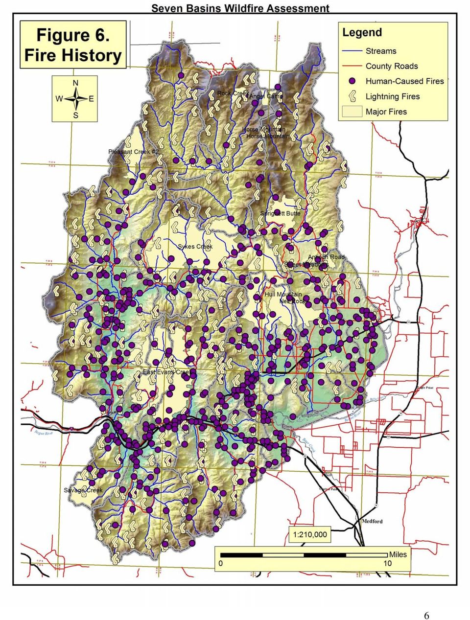
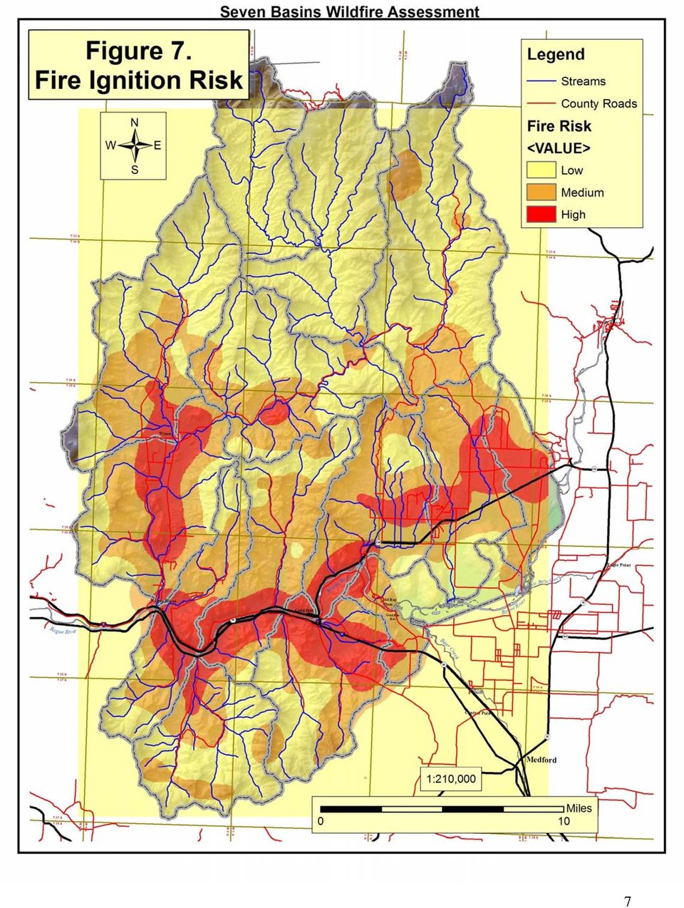
4 2.2 Wildfire Risk The Seven Basins watershed is a fire dependent ecosystem. The fire history record only goes back to 1872 but shows that there have been at least 16 major fires in that time ranging from 600 to 10,000 acres in size. Since 1968, there have been more than 1,400 fires in the watershed. Of these, lightning caused 290. The others were human-caused. Most fires were quickly extinguished and remained smaller than an acre. A few became large fires. Notable large fires during the period were Sykes Creek (1987) 10,000 acres, East Evans Creek (1992) 10,000 acres, and Hull Mountain (1994) 8,000 acres (figure 6). Wildfire risk refers to the potential for, or likelihood of, a wildfire ignition, regardless of its severity. Lightning strikes are somewhat random but are most common on ridge tops or other elevated topographic positions. The likelihood of human-caused fires increases with residential density and in proximity to heavily traveled roadways. Since most fires in the Seven Basins are human-caused, the overall risk of fire increases in more heavily populated areas. The areas within the watershed with the highest risk of fire (20+ fire incidents per 1,000 acres) are along the I-5 corridor, Hwy 234 immediately east of Gold Hill, selected spots in Sams Valley, and the Wimer area. Areas with lower relative risk (< 5 incidents per 1,000 acres) are generally found in wildland areas with low population density. It should be noted that fire starts in more remote areas, while less common, may also be more difficult to control because of limited access and other factors, and therefore may be more likely to grow into large fires. Two risk maps were created: one based on all ignitions, regardless of size, and one including only fires that reached 5 or more acres in size. The first map (figure 7) closely parallels the dwelling density map; that is, where people are found, so are fires. The second map (figure 8) in effect, shifts the areas of highest fire ignition density outward. For example, on the first map (all fires), the mid-evans Valley/Wimer area is shown as having high ignition risk. But, when considering only fires 5 acres and larger, much of this area shifts to low risk, while some outlying areas shift from low to moderate, or high risk. This is not surprising given the response times factor. Response time to a remote area is longer, thus fires have more time to grow larger. The 5-acre break point was arbitrary, but our data suggests that fire size is important when evaluating ignition risk. We believe that from the standpoint of prioritizing fuels reduction treatments on a neighborhood scale, it is more relevant to look at the ignition risk for larger-sized fires. 4

5 2.2 Wildfire Risk The Seven Basins watershed is a fire dependent ecosystem. The fire history record only goes back to 1872 but shows that there have been at least 16 major fires in that time ranging from 600 to 10,000 acres in size. Since 1968, there have been more than 1,400 fires in the watershed. Of these, lightning caused 290. The others were human-caused. Most fires were quickly extinguished and remained smaller than an acre. A few became large fires. Notable large fires during the period were Sykes Creek (1987) 10,000 acres, East Evans Creek (1992) 10,000 acres, and Hull Mountain (1994) 8,000 acres (figure 6). Wildfire risk refers to the potential for, or likelihood of, a wildfire ignition, regardless of its severity. Lightning strikes are somewhat random but are most common on ridge tops or other elevated topographic positions. The likelihood of human-caused fires increases with residential density and in proximity to heavily traveled roadways. Since most fires in the Seven Basins are human-caused, the overall risk of fire increases in more heavily populated areas. The areas within the watershed with the highest risk of fire (20+ fire incidents per 1,000 acres) are along the I-5 corridor, Hwy 234 immediately east of Gold Hill, selected spots in Sams Valley, and the Wimer area. Areas with lower relative risk (< 5 incidents per 1,000 acres) are generally found in wildland areas with low population density. It should be noted that fire starts in more remote areas, while less common, may also be more difficult to control because of limited access and other factors, and therefore may be more likely to grow into large fires. Two risk maps were created: one based on all ignitions, regardless of size, and one including only fires that reached 5 or more acres in size. The first map (figure 7) closely parallels the dwelling density map; that is, where people are found, so are fires. The second map (figure 8) in effect, shifts the areas of highest fire ignition density outward. For example, on the first map (all fires), the mid-evans Valley/Wimer area is shown as having high ignition risk. But, when considering only fires 5 acres and larger, much of this area shifts to low risk, while some outlying areas shift from low to moderate, or high risk. This is not surprising given the response times factor. Response time to a remote area is longer, thus fires have more time to grow larger. The 5-acre break point was arbitrary, but our data suggests that fire size is important when evaluating ignition risk. We believe that from the standpoint of prioritizing fuels reduction treatments on a neighborhood scale, it is more relevant to look at the ignition risk for larger-sized fires. 5

6 6
7 7
8 8

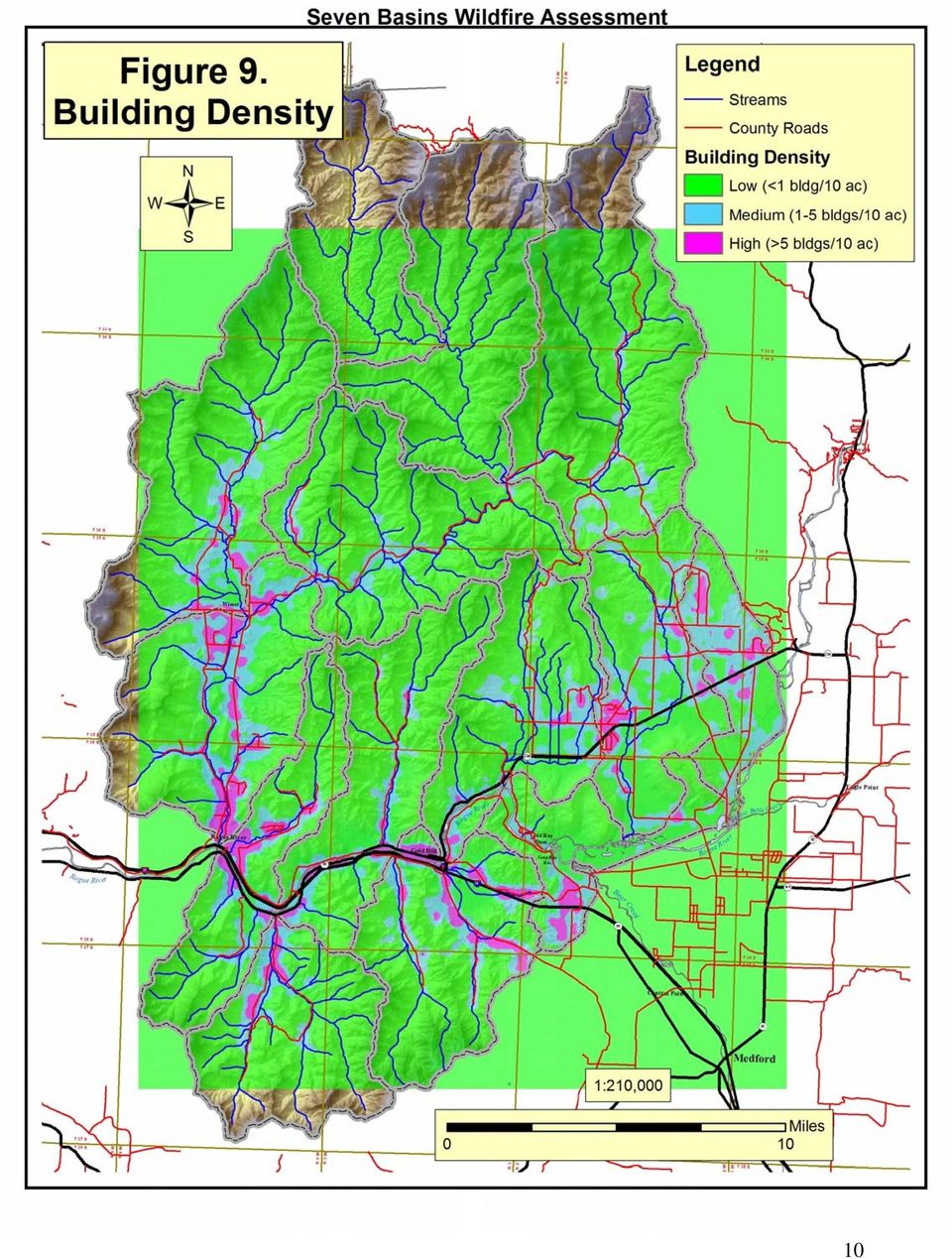
9 2.3 Residential Density Residential density is one measure of values-at-risk from wildfire. The rationale is simple: The more homes in a given area, the greater the risk of loss in a wildfire. For the study, a map layer was created depicting residential density throughout the watershed (figure 9). The measure of density used is the number of buildings per 10 acres. Values ranged from less than one to more than twenty-five buildings per 10 acres. We assigned the following classifications and point values: HIGH (40 points) = > 5 buildings per 10 acres MEDIUM (25 points) = 1-5 building per 10 acres LOW (10 points) = < 1 building per 10 acres 2.4 Senate Bill 360 Designated Lands Under Senate Bill 360, the wildland-urban interface has been classified in Jackson County using the following criteria: Lands that are urban or suburban, or are "included rural lands" Lands that have structures in a density of at least four structures per 40 acres Lands classified as forestland Lands within an ODF protection boundary Lands so classified were designated as either high or extreme risk based on vegetative characteristics and other factors. About 43,000 acres of private land in the Seven Basins watershed are classified under SB 360 (figure 10), encompassing nearly 4,800 dwellings (table 4). This includes much of the private, non-industrial land outside of urban and agricultural areas. Of the SB 360 acreage in the watershed, the vast majority is in the extreme risk category. (Note that our definition of the Wildland-Urban Interface includes all SB 360-designated land in the watershed as well as adjacent wildlands) Table 4. SB 360 acre, # of dwellings, & out of district dwellings, by sub-watershed Acreage SB360 # outof-fire Sub-watershed Name Total % BLM % Private Acres % Ext. 1 Dwellings 2 Density 3 District 4 Upper Evans Pleasant Creek Sykes Creek Dodge Bridge Snider Creek Sams Creek Lower Evans Wards Creek Whetstone Creek Galls Creek Foots Creek Sardine Creek Total % of SB 360 acres in sub-watershed that are in Extreme category 2 Estimated # of dwellings in SB360 mapped areas, including residences, mobile homes, unknowns, & SPR class 3 # of SB360 acres divided by # of dwellings 4 Only includes SB 360 residences 9
 = > 5 buildings per 10 acres MEDIUM (25 points) = 1-5 building per 10 acres LOW (10 points) = < 1 building per 10 acres 2.")
10 10
11 11

12 2.5 Overall Risk The risk layers for fire hazard, fire ignition risk (5+ acre fires), and residential density were combined to develop a composite risk rating. The factors were weighted as follows: Fuel hazard (0-95 points) Ignition risk (0-40 points) Density (0-40 points) Total points possible The following break points were used: HIGH = 95+ points MODERATE = points LOW = < 65 points The composite risk rating is one tool for evaluating treatment priorities at the neighborhood scale (figure 11). 2.6 Homesite Status Defensible Space Research indicates that the main factors influencing home survival in a wildfire are the roof type and other characteristics of the home, as well as the quality and extent of the defensible space. Defensible space is defined as treating vegetation around the home and driveway in such a way that it can be successfully defended in a wildfire. Based on records from homesite rebates and recent windshield surveys 1 of selected neighborhoods, it can be estimated that 91% of homesites in the Seven Basins watershed outside of urban areas are green ; that is, defensible in a wildfire (Table 5, Figure 12). The percentage of green homesite varies among neighborhoods, with some approaching 100% green and others with less than 70% green. Table 5. Homesite % green, by neighborhood Neighborhood Sub-watershed(s) # green # red % green Fire planning neighborhoods: Sykes Creek Sykes Creek Queen's Branch Pleasant/Lower Evans Foots Foots Creek Galls Galls Creek Manzanita Lower Evans R. Fk. Sardine Sardine Creek Holcomb Springs Sams Creek Profetta Lane Sardine Creek Subtotal Non-fire planning neighborhoods: Pleasant Creek Pleasant Creek E Evans Lower Evans Erhart Lower Evans Fielder Lower Evans Birdsye Wards Creek Ramsey Canyon Sams Creek/Upper Evans Antioch Snider Creek/Upper Evans Subtotal Subtotal Totals Homesite windshield surveys were based on a quick visual assessment of homesites with respect to SB 360 standards by an experienced fire professional. A green homesite would meet the standard; a red homesite would not. We regard the fuelbreak standards in SB 360 as a minimum for home defensibility. 12
. 2.")
13 13

14 14

15 Roof type & other home characteristics No data was available on roof type, but a general impression is that relatively few homes in the WUI have shake roofs. There also was no data about home materials and design in relation to the potential for structural ignitability. However, since 1994, Jackson County has required all new construction to meet standards for fire safe building materials, home design, road and driveway access, and a homesite fuel break. 2.7 Roads & Access Issues Safe ingress and egress in the event of a wildfire is a significant issue throughout the watershed. There are a number of steep-sided canyons, essentially with one way in and out. Examples include Galls Creek, Wards Creek, Fielder Creek, Sardine Creek, and Sykes Creek. In many cases these are two-lane, county-owned roads. With respect to fuels in the right-ofway and just beyond, most county roads are in good shape, but there are some problem areas. Members of the Fire Planning project steering committee met with County Roads personnel to discuss these issues in One result was more aggressive clearing of hazardous fuels in the right-of-way, for example, along Sardine Creek. Hazardous fuels along driveways and private roads, which access multiple dwellings, especially on dead-end roads, are a major concern. This includes county road segments that are privately maintained. Driveways and private access roads are part of a homesite s defensible space. Steep, narrow roads with overhanging vegetation present an unsafe "tunnel" for firefighters. Regardless of what lies beyond, they may turn around rather than risk firefighter lives and equipment. Individual driveways are assessed during ODF s homesite consultations. If work is needed, it is typically included as part of the defensible space treatment plan. As the plan was developed, selected areas of the watershed were visited by ODF personnel to evaluate access road issues. Several problem roads were identified and are noted in the mitigation plan subwatershed summaries below. However, no systematic effort was made to identify and map dead end roads. As part of the Seven Basins Neighborhood Fire Planning project, Job Council crews completed fuels treatment on five private access road segments (figure 13). Figure 13: Job Council crew treated private access road. 15

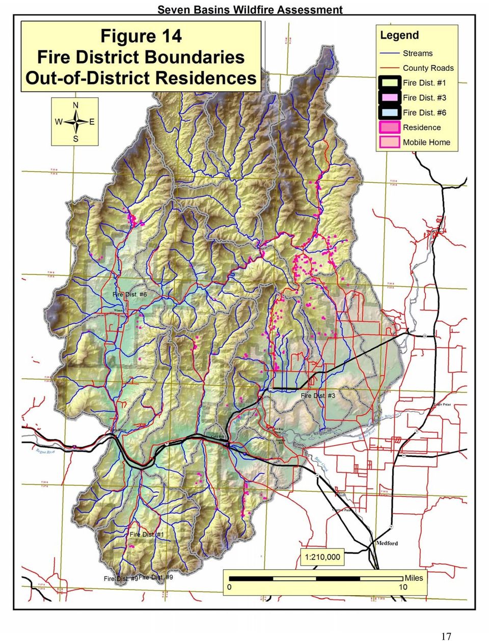
16 2.8 Fire Protection Capabilities Structural Fire Protection Structural fire protection in the watershed is provided by District #3 (Sams Valley), District #1 (Rogue River) and District #6 (Upper Evans Valley) (figure 13). District #3 is a large district with multiple sub-stations. District #1 has 11 employees plus volunteers. District #6 has two paid staff, plus volunteers. Out-of-District residences Dwellings outside fire district boundaries lack structural fire protection. There are at least 359 such residences in the watershed (about 1,200 structures total) (figure 14, table 4). The majority of these are in the Sams Creek (Ramsey Road) and Upper Evans sub-watersheds, although small pockets are found in other sub-watersheds. Out-of-District residences are likely to be at higher risk of fire. Because of this, they may pose additional risks for adjacent wildlands (e.g., a structure fire in an out-of-district area may spread more easily to surrounding wildlands because of the lack of structural fire protection). This is believed to be an important factor in identifying priorities for fuels reduction projects. Wildland Fire Protection The Oregon Department of Forestry (ODF) provides fire protection on forest and grazing lands in Jackson and Josephine Counties. These include private lands as well as lands managed by the county, state, and Bureau of Land Management. ODF s services include fire prevention, detection, and suppression. ODF works collaboratively with landowners and other fire agencies. During fire season, ODF has fire engines staffed throughout the watershed including Rogue River, Wimer, and Gold Hill/Sams Valley. During extreme fire situations ODF has access to additional fire engines, dozers, hand crews and aircraft, including helicopters, retardant planes and recon aircraft. ODF's priorities are life, resources and property. ODF is not authorized, trained, funded or equipped to fight structure fires. Neighborhood Emergency Response Capabilities Neighborhoods vary in their level of preparation for wildfire emergencies. Some have informal networks that allow for rapid sharing of information. Others have formal phone trees and evacuation plans. Through the Seven Basins project, 21 neighborhoods to date have participated in neighborhood planning and 19 completed neighborhood plans. These plans included phone trees, with designated dispatchers, inventories of neighborhood fire-related resources, and in many cases, identification of water sources and safe zones. In most cases, neighborhoods elected to provide their phone list to ODF and the local fire district. Resource lists were kept within neighborhoods due to privacy concerns. Of the 19 neighborhoods that completed plans, at least 14 are still actively maintaining their phone lists (figure 15). These neighborhoods are better prepared for wildfires and thus at lower risk. 16
 (figure 14, table 4).")
17 17
18 18

19 2.9 Risk Assessment Summary Using the risk assessment maps, high risk neighborhoods were identified (figure 16). High risk neighborhoods were defined as those where at least 10 dwellings were located in a contiguous area of high to extreme fire hazard (section 2.1) or high overall risk (section 2.5) (Table 6). These finding served as one of several key criteria for evaluating neighborhood fuels reduction priorities, as detailed in section 4.2 (Mitigation Plan). Note that high risk neighborhoods in this plan are not the same as high priority neighborhoods. See section 4.2 for details. As a check, we compared our list of high risk neighborhoods with Senate Bill 360 risk classifications. All the high risk neighborhoods, except one (Blackwell Rd.), fell into the SB 360 extreme risk category. Blackwell Rd fell into the SB 360 high risk category. Table 6. High risk neighborhoods, by sub-watershed Sub-watershed High Risk Neighborhood Dodge Bridge none Foots Creek Upper Right Fork Galls Creek City of Gold Hill (7 th St.) Blackwell Rd. Old Stage Rd. Lower Evans W. Evans - Carlos W. Evans E. Evans Trimble Creek Fielder Creek Manzanita Drive Earhart Road Hidden Valley Drive Sykes-- May Creek Sykes Creek Pleasant Creek Pleasant Creek Rd. Pleasant Creek -- Lower Ditch Creek -- Upper Ford Road W. Evans Rd. Sams Creek Rock Creek -- Duggan Rd McDonough Rd Holcomb Springs Rd Sardine Creek Upper Rt Fk -- Middle Fk -- Lwr Rt Fk Left Fork Snider Creek Valley Vista Upper Evans none Wards Creek Tenney Drive N River Rd Valley of the Rogue #1 Birdseye Creek Whetstone Creek n 19

20 20

6. NATURAL AREAS FIRE MANAGEMENT
 6. NATURAL AREAS FIRE MANAGEMENT 6-1 Wildfire management is an important component of managing and maintaining County natural areas. The natural areas are woven into the community fabric and are a part
Initially 2 zones (adjacent & extended) established in the 2005 CWPP, Modification to improve planning integration made in 2010.
 established in the 2005 CWPP, Modification to improve planning integration made in 2010.") 4) Fire Risk Mitigation Strategies This section is divided into four areas of focus. Mitigation strategies are prioritized by zone, with the highest priority being the structure ignition zone and working
4) Fire Risk Mitigation Strategies This section is divided into four areas of focus. Mitigation strategies are prioritized by zone, with the highest priority being the structure ignition zone and working
Your Defensible Space Slideshow
 Your Defensible Space Slideshow Red = Trees to Remove Your Defensible Space Slideshow This slideshow was created to highlight actions you can take to dramatically improve the chances of your home surviving
Wildfires pose an on-going. Integrating LiDAR with Wildfire Risk Analysis for Electric Utilities. By Jason Amadori & David Buckley
 Figure 1. Vegetation Encroachments Highlighted in Blue and Orange in Classified LiDAR Point Cloud Integrating LiDAR with Wildfire Risk Analysis for Electric Utilities Wildfires pose an on-going hazard
Hazard Identification and Risk Assessment
 Wildfires Risk Assessment This plan is an update of the 2004 City of Redmond Hazard Mitigation Plan (HMP). Although it is an update, this document has been redesigned so that it looks, feels, and reads
The National Wildfire Mitigation Programs Database: State, County, and Local Efforts to Reduce Wildfire Risk 1
 Proceedings of the Second International Symposium on Fire Economics, Planning, and Policy: A Global View The National Wildfire Mitigation Programs Database: State, County, and Local Efforts to Reduce Wildfire
The Wildland-Urban Interface in the United States
 The Wildland-Urban Interface in the United States Susan I. Stewart Northern Research Station, USDA Forest Service, Evanston, IL (sistewart@fs.fed.us) Volker C. Radeloff Department of Forestry, University
Application No.: 14.074 Steve Rush, representing Rocky Mountain Power Rocky Mountain Power Project Location: approximately 1600 N. 6800 E.
 Planning Commission Staff Report Planning and Development Services Croydon Substation Conditional Use Permit Public Meeting August 28, 2014 Application No.: 14.074 Applicant: Steve Rush, representing Rocky
King Fire Restoration Project, Eldorado National Forest, Placer and El Dorado Counties, Notice of intent to prepare an environmental impact statement.
 This document is scheduled to be published in the Federal Register on 12/24/2014 and available online at http://federalregister.gov/a/2014-30158, and on FDsys.gov [3410-11- P] DEPARTMENT OF AGRICULTURE
Increasing the Outreach Capacity of Wildland Fire Agencies through Education and Volunteer Service
 Increasing the Outreach Capacity of Wildland Fire Agencies through Education and Volunteer Service Rhianna Simes OSU Extension Southern Oregon Steve Fitzgerald OSU Extension Central Oregon Max Bennett
National Hazard and Risk Model (No-HARM) Wildfire
 Wildfire") National Hazard and Risk Model (No-HARM) Wildfire A Briefing Paper Anchor Point Group LLC 2131 Upland Ave. Boulder, CO 80304 (303) 665-3473 www.anchorpointgroup.com Summary The potential for wildfire-caused
National Hazard and Risk Model (No-HARM) Wildfire A Briefing Paper Anchor Point Group LLC 2131 Upland Ave. Boulder, CO 80304 (303) 665-3473 www.anchorpointgroup.com Summary The potential for wildfire-caused
Mission Canyon Residential Design Guidelines Workshop. Table Focus: Environmental Issues and Concerns
 Mission Canyon Residential Design Guidelines Workshop Table Focus: Environmental Issues and Concerns Grading How is Grading Regulated in Santa Barbara County? The technical aspects of grading are regulated
Rural Residential Buildable Lands Inventory
 The Dalles Periodic Review, May 2013 Rural Residential Lands Inventory Contents Introduction and Summary... 1 Concerns related to the 2007 Analysis... 2 Rural Residential Capacity Summary... 2 Methodology...
Southern California Insect related Tree Mortality. GIS Master Plan September 2003
 Southern California Insect related Tree Mortality GIS Master Plan September 2003 Abstract Consecutive years of below-average precipitation from 1998 to 2003 resulted in large-scale insect outbreaks in
NEW DENVER / SILVERTON FIRE PROTECTION AREA COMMUNITY WILDFIRE PROTECTION PLAN PART 2
 NEW DENVER / SILVERTON FIRE PROTECTION AREA COMMUNITY WILDFIRE PROTECTION PLAN Considerations for Wildland Urban Interface Management in the New Denver / Silverton Fire Protection Area, British Columbia
Background research on the topic of urban forestry is intended to
 overview urban forestry Urban Forestry Background research on the topic of urban forestry is intended to help guide the task of integrating trees and urban forestry goals and aspirations into the Portland
Response Levels and Wildland Fire Decision Support System Content Outline
 Response Levels and Wildland Fire Decision Support System Content Outline In wildland fire management, practitioners are accustomed to levels of incident management, initial attack response, dispatch levels,
Wildland Fire. GIS Solutions for Wildland Fire Suppression
 Wildland Fire GIS Solutions for Wildland Fire Suppression Applying GIS Technology to Wildland Fire Fire Decision Support Tools When it comes to wildfire protection local, state, and federal agencies must
Description of Simandou Archaeological Potential Model. 13A.1 Overview
 13A Description of Simandou Archaeological Potential Model 13A.1 Overview The most accurate and reliable way of establishing archaeological baseline conditions in an area is by conventional methods of
monitor You Too Can Prevent Wildfires Smokey Bear Turned 65! the Environmental
 Published quarterly by the Association of Environmental Professionals NAEP Affiliation monitor the Environmental Fall 2010 You Too Can Prevent Wildfires Smokey Bear Turned 65! 2011 AEP Award Submittal
Integrating Landscape Restoration and CWPP
 Integrating Landscape Restoration and CWPP Two approaches: One or more CWPP embedded in a larger landscape to achieve multiple objectives CWPP that encompasses a larger landscape to achieve multiple objectives
Jackson Hydroelectric Project (FERC Project No. 2157) Revised Study Plan 12: Northern Spotted Owl Surveys. Final Technical Report
 Revised Study Plan 12: Northern Spotted Owl Surveys. Final Technical Report") (FERC Project No. 2157) Revised Study Plan 12: Northern Spotted Owl Surveys Final Technical Report Prepared for: Public Utility District No. 1 of Snohomish County Everett, Washington Prepared by: Biota
(FERC Project No. 2157) Revised Study Plan 12: Northern Spotted Owl Surveys Final Technical Report Prepared for: Public Utility District No. 1 of Snohomish County Everett, Washington Prepared by: Biota
Wildland Fire Decision Support Tools
 Wildland Fire Decision Support Tools Numerous support tools for intelligence gathering and analyses are readily available to aid fire managers and administrators in making risk informed decisions. These
CHAPTER 0340 FIRE PROTECTION POLICIES
 CHAPTER 0340 FIRE PROTECTION POLICIES FIRE PROTECTION OBJECTIVES 0341 The Board of Forestry and Fire Protection, ( Board) recognizes that the California Department of Forestry and Fire Protection's (Department)
Salmon-Challis National Forest Salmon and Challis Field Offices Idaho Falls District BLM
 Central Idaho Interagency Fire Center 2011 Annual Report Salmon-Challis National Forest Salmon and Challis Field Offices Idaho Falls District BLM OVERVIEW Central Idaho Interagency Fire Center (CIFC) provides
Wildfire & Flash Flood Recovery NACo Justice & Public Safety Symposium January 2014
 Wildfire & Flash Flood Recovery NACo Justice & Public Safety Symposium January 2014 Fall 2013 Jim Reid Executive Director Public Service El Paso County, Colorado Recovery Specific to Incident Recovery
Chapter 01 Federal Wildland Fire Management Policy and Guidance Overview
 FEDERAL FIRE PROGRAM POLICY AND GUIDANCE OVERVIEW CHAPTER 0 0 0 Chapter 0 Federal Wildland Fire Management Policy and Guidance Overview Scope The Interagency Standards for Fire and Fire Aviation Operations
A Guide to Hazard Identification and Risk Assessment for Public Health Units. Public Health Emergency Preparedness Protocol
 A Guide to Hazard Identification and Risk Assessment for Public Health Units Public Health Emergency Preparedness Protocol Emergency Management Unit Public Health Division Ministry of Health and Long-Term
18 voting members 44 stakeholders 114 email list. Senators: Wyden & Merkley Representative DeFazio
 18 voting members 44 stakeholders 114 email list Senators: Wyden & Merkley Representative DeFazio State Representative Krieger State Senators: Roblan, Johnson, and Kruse Governor Brown s office County
The specific goals of the assessment are the following:
 Purpose and Methods Section 2 Risk Assessment A primary component of the Lane County CWPP is the Wildfire Risk Assessment, which assesses the potential loss of lives, property and essential infrastructure
Richmond City s Green Infrastructure Assessment
 Richmond City s Green Infrastructure Assessment Presented by Karen Firehock, Director The Green Infrastructure Center Inc. www.gicinc.org Mike Mather, City Arborist City of Richmond Winter Symposium --
Fuels Treatments Reduce Wildfire Suppression Cost Merritt Island National Wildlife Refuge May 2012
 Fuels Treatments Reduce Wildfire Suppression Cost Merritt Island National Wildlife Refuge May 2012 Merritt Island National Wildlife Refuge Where Technology and Nature Intersect Authors Jennifer Hinckley
Post-Wildfire Clean-Up and Response in Houston Toad Habitat Best Management Practices
 Post-Wildfire Clean-Up and Response in Houston Toad Habitat Best Management Practices Purpose The purpose of this document is to provide guidance and recommendations for minimizing potential impacts to
STANDARDS FOR RANGELAND HEALTH ASSESSMENT FOR SAGEHEN ALLOTMENT #0208
 STANDARDS FOR RANGELAND HEALTH ASSESSMENT FOR SAGEHEN ALLOTMENT #0208 RANGELAND HEALTH STANDARDS - ASSESSMENT SAGEHEN ALLOTMENT #0208 STANDARD 1 - UPLAND WATERSHED This standard is being met on the allotment.
Wildfire & Flash Flood Recovery Emergency Watershed Protection (EWP) Flood Mitigation Efforts April 2014. Fall 2013
 Flood Mitigation Efforts April 2014. Fall 2013") Wildfire & Flash Flood Recovery Emergency Watershed Protection (EWP) Flood Mitigation Efforts April 2014 Fall 2013 Recovery Specific to Incident Recovery Efforts Depend on: Population Impacted Topography
Wildfire & Flash Flood Recovery Emergency Watershed Protection (EWP) Flood Mitigation Efforts April 2014 Fall 2013 Recovery Specific to Incident Recovery Efforts Depend on: Population Impacted Topography
INITIAL ATTACK DISPATCH CENTER - COMPLEXITIES
 INITIAL ATTACK DISPATCH CENTER - COMPLEXITIES A dispatch center s complexity is determined by the program complexity of the units supported by that dispatch center. A unit s program complexity is computed
Wildland-Urban Interface
 Wildland-Urban Interface Joe Holmes and James van Hemert The Rocky Mountain Land Use Institute Sustainable Community Development Code Research Monologue Series: Environmental Health Wildland-Urban Interface
PUBLIC DRAFT CONTENTS
 CONTENTS 9. Facilitating Fire Safety in the Santa Monica Mountains over the Long Term... 1 9.1. Monitoring... 1 9.1.1. Project Monitoring... 2 Photo Point Monitoring... 3 9.1.2. Ecological Monitoring...
Federal Assistance for Wildfire Response and Recovery
 Federal Assistance for Wildfire Response and Recovery Katie Hoover Analyst in Natural Resources Policy September 18, 2015 Congressional Research Service 7-5700 www.crs.gov R41858 Raging wildfires, burned
Case Study: The History of the San Juan Headwaters Forest Health Partnership
 Case Study: The History of the San Juan Headwaters Forest Health Partnership Introduction: Wildfire is a part of life in Southwest Colorado. It plays an integral role in ecosystem health and management.
Testimony of Diane Vosick, Director of Policy and Partnerships
 Testimony of Diane Vosick, Director of Policy and Partnerships The Ecological Restoration Institute, Northern Arizona University http://www.eri.nau.edu/ Before the House Federal Lands Subcommittee April
Wildfire Matters Review Committee
 Wildfire Matters Review Committee Members of the Committee Senator Jeanne Nicholson, Chair Representative Millie Hamner, Vice-Chair Senator Matt Jones Senator Steve King Senator Ellen Roberts Senator Lois
A Report on the City of Philadelphia s Existing and Possible Tree Canopy
 A Report on the City of Philadelphia s Existing and Possible Tree Canopy Why is Tree Canopy Important? Tree canopy (TC) is the layer of leaves, branches, and stems of trees that cover the ground when viewed
Request for Proposal (RFP) Black Forest Community Wildfire Protection Plan (CWPP) Update
 Black Forest Community Wildfire Protection Plan (CWPP) Update") Black Forest Together Inc. (BFT) 11590 Black Forest Road, Suite 30 Colorado Springs, CO 80908 719-495-2445 (office) Request for Proposal (RFP) Black Forest Community Wildfire Protection Plan (CWPP) Update
Black Forest Together Inc. (BFT) 11590 Black Forest Road, Suite 30 Colorado Springs, CO 80908 719-495-2445 (office) Request for Proposal (RFP) Black Forest Community Wildfire Protection Plan (CWPP) Update
FIRE INSURANCE AVAILABILITY IN HIGH RISK AREAS
 Lead Committee: Transaction and Regulatory Committee Information Committee: Land Use and Environmental Committee Level of Government Committee: Legislative Committee 09/24/13 FIRE INSURANCE AVAILABILITY
9 - Wildland Fire Decision Support System Overview. S-590 Advanced Fire Behavior Interpretation
 INSTRUCTOR: LESSON: 9 - Wildland Fire Decision Support System Overview COURSE: S-590 Advanced Fire Behavior Interpretation Emphasis: introduce concepts of WFDSS decision support and available models and
An Esri White Paper April 2011 GIS Technology: Supporting the Wildfire Mission
 An Esri White Paper April 2011 GIS Technology: Supporting the Wildfire Mission Esri, 380 New York St., Redlands, CA 92373-8100 USA TEL 909-793-2853 FAX 909-793-5953 E-MAIL info@esri.com WEB esri.com Copyright
Revising the Nantahala and Pisgah Land Management Plan Preliminary Need to Change the Existing Land Management Plan
 Revising the Nantahala and Pisgah Land Management Plan Preliminary Need to Change the Existing Land Management Plan Throughout the Plan 1. There is a fundamental need for the revised plan to address how
Hazardous Fuels Treatment Effectiveness on Utah BLM Lands
 Hazardous Fuels Treatment Effectiveness on Utah BLM Lands J. Bradley Washa - State Fuels Specialist, Utah State Office, DOI Bureau of Land Management Since inception of the National Fire Plan, 112 hazardous
My friends and neighbors refer to the cabin as the Miracle Cabin because it has survived two wildfires.
 & Insurance Wildfire is a growing threat in the Rocky Mountain Region, where the population is booming in the mountains and foothills. People often don t realize the dangers of living in the Red Zone (dangerous
Since early 1994, The Northern Sacramento Valley Sustainable Landscapes
 Using Population Distribution Forecasts and GIS Technology to Assess Potential Hardwood Loss in the Northern Sacramento Valley 1 Charles W. Nelson 2 Mark Radabaugh 3 Abstract: Since its inception, The
Guidance for Implementation of Federal Wildland Fire Management Policy
 Guidance for Implementation of Federal Wildland Fire Management Policy February 13, 2009 Page 1 Foreword The Review and Update of the 1995 Federal Wildland Fire Management Policy (January 2001) is the
Chapter 1b - Priority Map Development
 North Carolina s Forest Resources Assessment A statewide analysis of the past, current and projected future conditions of North Carolina s forest resources 2010 Chapter 1b - Priority Map Development This
Arizona s Large Fires Suppression vs. Restoration. WESTCAS Fall 2011 Meeting Bruce Hallin Manager, Water Rights and Contracts October 27, 2011
 Arizona s Large Fires Suppression vs. Restoration WESTCAS Fall 2011 Meeting Bruce Hallin Manager, Water Rights and Contracts October 27, 2011 THE PROBLEM Unhealthy Forests Since 2000, at least 1,501,654
FRONT RANGE WATERSHED PROTECTION DATA REFINEMENT WORK GROUP
 FRON RANGE WAERSHED PROECION DAA REFINEMEN WORK GROUP PROECING CRIICAL WAERSHEDS IN COLORADO FROM WILDFIRE: A ECHNICAL APPROACH O WAERSHED ASSESSMEN AND PRIORIIZAION EXECUIVE SUMMARY FEBRUARY 2009 PROECING
2015 CRAIG INTERAGENCY FIRE MANAGEMENT GROUP (CIFMG) ANNUAL OPERATING PLAN
 ANNUAL OPERATING PLAN") 2015 CRAIG INTERAGENCY FIRE MANAGEMENT GROUP (CIFMG) ANNUAL OPERATING PLAN Craig Interagency Dispatch Center (CRC) Bureau of Land Management () Northwest District, Including Little Snake (LSD), Kremmling
2015 CRAIG INTERAGENCY FIRE MANAGEMENT GROUP (CIFMG) ANNUAL OPERATING PLAN Craig Interagency Dispatch Center (CRC) Bureau of Land Management () Northwest District, Including Little Snake (LSD), Kremmling
MAPPING MINNEAPOLIS URBAN TREE CANOPY. Why is Tree Canopy Important? Project Background. Mapping Minneapolis Urban Tree Canopy.
 MAPPING MINNEAPOLIS URBAN TREE CANOPY Why is Tree Canopy Important? Trees are an important component of urban environments. In addition to their aesthetic value, trees have significant economic and environmental
Fire Management needs assessment and priority actions
 Needs Assessment Questionnaire Fire Management needs assessment and priority actions In the introduction of the guidelines it is said that the Principles and Strategic Actions can serve as a checklist
Table of Contents Introduction Page 3. Definitions Page 3. District Description Page 4. Legal existence of the fire district Page 4
 Kitsap County Fire District 18/Poulsbo 2014 Annual Report of Service Level Objectives Table of Contents Introduction Page 3 Definitions Page 3 District Description Page 4 Legal existence of the fire district
Wildland Fire Position Descriptions
 Wildland Fire Position Descriptions This document gives brief position descriptions. The career tracks and career timelines are color coded to the Fire Management Career Ladders graphic. Operations Early
Fireline Rehabilitation on Donnelly Flats fire (B222) Summary: 7/1/99 R.R. Jandt
 Summary: 7/1/99 R.R. Jandt") Fireline Rehabilitation on Donnelly Flats fire (B222) Summary: 7/1/99 R.R. Jandt Assessment- During the suppression effort approximately 20-25 miles of bladed fireline was built using D-8-equivalent dozers.
Fireline Rehabilitation on Donnelly Flats fire (B222) Summary: 7/1/99 R.R. Jandt Assessment- During the suppression effort approximately 20-25 miles of bladed fireline was built using D-8-equivalent dozers.
Fighting Fire with Fire: Can Fire Positively Impact an Ecosystem?
 Fighting Fire with Fire: Can Fire Positively Impact an Ecosystem? Science Topic: Fire Ecology Grades: 6 th 8 th Essential Questions: What role does fire play in maintaining healthy ecosystems? How does
The Importance of Garbage Clearing and vegetation
 BHFD Fire Prevention Bureau 445 North Rexford Drive Beverly Hills, CA 90210 2014 BEVERLY HILLS FIRE DEPARTMENT Beverly Hills Fire Department BRUSH CLEARANCE PROGRAM INFORMATION BROCHURE Your property is
Craig Interagency Dispatch Center 2013 Year End Report
 Craig Interagency Dispatch Center 2013 Year End Report Citadel Fire July 30 th, 2013 Photo Credit: Bob Detman Cooperating Agencies Bureau of Land Management United States Forest Service National Park Service
NWCG Training Curriculum History
 NWCG Training Curriculum History DISPATCH D-105 Entry Level Dispatcher* D-110 Expanded Dispatch Recorder D-111 Entry Level Dispatcher* D-310 Expanded Support Dispatcher 4/92 changed to D-111 in 2/00; reference
SILVICULTURE OF THE COLORADO FRONT RANGE LANDSCAPE RESTORATION INITIATIVE
 SILVICULTURE OF THE COLORADO FRONT RANGE LANDSCAPE RESTORATION INITIATIVE Silvicultural Practices & Implementation Methods Through 3 Years Of Fuels Reduction & Restoration Treatments Collaborative Forest
Community Wildfire Protection Plan Evaluation Guide
 Community Wildfire Protection Plan Evaluation Guide August 2008 Prepared by Resource Innovations Institute for a Sustainable Environment University of Oregon http://ri.uoregon.edu Community Wildfire Protection
2002 (Revised 09/2009)
") Department of the Interior Bureau of Land Management Glenwood Springs Field Office 2002 (Revised 09/2009) i I. Introduction I-1 I.A. Purpose I-1 I.A.1 National Direction for ning I-1 I.B. Relationship
Department of the Interior Bureau of Land Management Glenwood Springs Field Office 2002 (Revised 09/2009) i I. Introduction I-1 I.A. Purpose I-1 I.A.1 National Direction for ning I-1 I.B. Relationship
City of Colleyville Community Development Department. Site/Landscape Plan Application Packet
 City of Colleyville Community Development Department Site/Landscape Plan Application Packet Development Application Fees City of Colleyville 100 Main Street Colleyville TX 76034 817.503.1050 Zoning Zoning
KC CWPP.doc 7/11/2007 11:19:50 AM Page 1 of 91
 The Klamath County Community Wildfire Protection Plan, or KC CWPP, has been completed. The final copy will be officially signed by the Klamath County Commissioners at their July 24, 2007 meeting. This
What is the Dirt Worth?
 Terry Gilmore and Martin J. Healy, Jr. What is the Dirt Worth? In this article, issues within the timber industry affecting cutover timberland values are examined in an attempt to help appraisers determine
Nevada Pinyon-Juniper Partnership Proposed Demonstration Area A Brief Introduction. Presented by Jeremy Drew Project Manager Resource Concepts, Inc.
 Nevada Pinyon-Juniper Partnership Proposed Demonstration Area A Brief Introduction Presented by Jeremy Drew Project Manager Resource Concepts, Inc. What I ll Discuss: Purpose of a Demonstration Area Priorities
Communities and Fire Restoration. The Role of Communities in Restoring Fire as a Natural Process
 Communities and Fire Restoration The Role of Communities in Restoring Fire as a Natural Process Overview 1. Frequent fire regimes dominate approximately 65% of the lower 48 states, although regional variations
CITY OF BOULDER WILDLAND URBAN INTERFACE COMMUNITY WILDFIRE PROTECTION PLAN
 CITY OF BOULDER WILDLAND URBAN INTERFACE COMMUNITY WILDFIRE PROTECTION PLAN Prepared for: City of Boulder Boulder, Colorado Submitted By: Anchor Point Boulder, Colorado September 2007 TABLE OF CONTENTS
Analysis of Wildfire Likelihood and Opportunities For Mitigation in the Chornobyl Forestscape
 Analysis of Wildfire Likelihood and Opportunities for Mitigation in the Chernobyl Irradiated Forests By James McCarter, Sergiy Zibtsev, Aaron Hohl, Mykhaylo Petrenko LMS Portfolios The Landscape Management
HFQLG Project Evaluation Form
 HFQLG Evaluation Form Names: Watershed Restoration Defensible Fuel Profile Zone Loyalton Pines Wildland Urban Interface Fuels Reduction Types: Watershed Restoration - Implemented pond and plug restoration
LEAGUE NOTES ON APPROVED COMMUNITY WATER SUPPLY PLAN
 1 AUGUST 2011 LEAGUE NOTES ON APPROVED COMMUNITY WATER SUPPLY PLAN KEY ELEMENTS OF THE PLAN: 1. Replace the existing unsafe Ragged Mountain dam with a new dam and raise the reservoir pool level initially
GREEN SHEET. California Department of Forestry and Fire Protection
 GREEN SHEET California Department of Forestry and Fire Protection Informational Summary of Serious CAL FIRE Injuries, Illnesses, Accidents & Near-Miss Incidents Pine Fire Wildland Fire Entrapment & Burn-Over
2002 URBAN FOREST CANOPY & LAND USE IN PORTLAND S HOLLYWOOD DISTRICT. Final Report. Michael Lackner, B.A. Geography, 2003
 2002 URBAN FOREST CANOPY & LAND USE IN PORTLAND S HOLLYWOOD DISTRICT Final Report by Michael Lackner, B.A. Geography, 2003 February 2004 - page 1 of 17 - TABLE OF CONTENTS Abstract 3 Introduction 4 Study
A GUIDE: DEVELOPING A STREET AND PARK TREE MANAGEMENT PLAN
 A GUIDE: DEVELOPING A STREET AND PARK TREE MANAGEMENT PLAN An introduction to the preparation of a strategic approach to the care and maintenance of your community forest USDA Forest Service Northeastern
Statement Rick D. Cables Rocky Mountain Regional Forester U.S. Forest Service United States Department of Agriculture
 Statement Rick D. Cables Rocky Mountain Regional Forester U.S. Forest Service United States Department of Agriculture Subcommittee on Forests and Forest Health Committee on Resources United States House
National Wildfire Coordinating Group Communicator's Guide for Wildland Fire Management: Fire Education, Prevention, and Mitigation Practices
 National Wildfire Coordinating Group Communicator's Guide for Wildland : Fire Education, Prevention, and Mitigation Practices 3. 3. A. Wildland Agencies and their Roles i. National Interagency Fire Center
The LAndscape Management Policy Simulator (LAMPS) Pete Bettinger Department of Forest Resources Oregon State University
 Pete Bettinger Department of Forest Resources Oregon State University") The LAndscape Management Policy Simulator (LAMPS) Pete Bettinger Department of Forest Resources Oregon State University CLAMS Landscape Planning and Analysis Process Existing forest inventories Management
The LAndscape Management Policy Simulator (LAMPS) Pete Bettinger Department of Forest Resources Oregon State University CLAMS Landscape Planning and Analysis Process Existing forest inventories Management
National Interagency Aviation Council (NIAC) Phase III Strategy
 Phase III Strategy") National Interagency Aviation Council (NIAC) Phase III Strategy I am happy to be here today. Aviation remains a key component to wildland fire management. The future for the agencies will undoubtedly involve
National Interagency Aviation Council (NIAC) Phase III Strategy I am happy to be here today. Aviation remains a key component to wildland fire management. The future for the agencies will undoubtedly involve
Slope Density. Appendix F F-1 STATEMENT OF PURPOSE DISCUSSION OF SLOPE
 Appendix F Slope Density F-1 STATEMENT OF PURPOSE This document has been prepared with the intent of acquainting the general reader with the slope-density approach to determining the intensity of residential
Better than Ever : Partnership of Community Liaisons, USFS & Incident Management Cohesive Strategy Success Story
 Better than Ever : Partnership of Community Liaisons, USFS & Incident Management Cohesive Strategy Success Story State: California Goal 2: Fire Adapted Communities They listened and did what they said
Appendix A: Affordable Housing Site Inventory
 Appendix A: Affordable Housing Site Inventory Following is a brief summary of the various sites considered for the Affordable Housing Project. Each site is provided with a photo when available and a concise
DOUGLAS COUNTY ZONING RESOLUTION Section 5 RR - Rural Residential District 3/10/99. -Section Contents-
 SECTION 5 RR - RURAL RESIDENTIAL DISTRICT -Section Contents- 501 Intent...5-2 502 Principal Uses...5-2 503 Accessory Uses...5-3 504 Uses Permitted by Special Review...5-4 505 Land Dedication...5-4 506
Wildlife Habitat Conservation and Management Program
 Wildlife Habitat Conservation and Management Program Manual for Counties and Cities Oregon Department of Fish and Wildlife 2015 Table of Contents 1. Introduction Purpose of the habitat program Objective
Interagency Strategy for the Implementation of Federal Wildland Fire Management Policy. June 20, 2003
 Interagency Strategy for the Implementation of Federal Wildland Fire Management Policy Table of Contents Executive Summary... 1 Preface... 3 Introduction... 5 Purpose... 5 Operational Clarification for
Comparison of Satellite Imagery and Conventional Aerial Photography in Evaluating a Large Forest Fire
 Purdue University Purdue e-pubs LARS Symposia Laboratory for Applications of Remote Sensing --98 Comparison of Satellite Imagery and Conventional Aerial Photography in Evaluating a Large Forest Fire G.
SANTA BARBARA COUNTY COMPREHENSIVE PLAN LOMPOC AREA
 SANTA BARBARA COUNTY COMPREHENSIVE PLAN LOMPOC AREA A. LAND USE ELEMENT INTERPRETIVE GUIDELINES B. COMMUNITY BENEFITS C. COUNTY ACTION ITEMS Adopted by the Board of Supervisors November 9, 1999 A. Santa
Landscaping with Ornamental Trees and Exterior Structure Features Using EcoSmart Fire Model
 Landscaping with Ornamental Trees and Exterior Structure Features Using EcoSmart Fire Model Mark A. Dietenberger, Ph.D., USDA, FS, Forest Products Laboratory, Madison, Wisconsin, USA, mdietenberger@fs.fed.us
Planning for Bushfire Risk Mitigation General Code
 Planning for Bushfire Risk Mitigation General Code March 2008 Contents 0H1. Introduction 14H1 1H1.1 Purpose... 2H1.2 Aim... 3H2. Principles 17H2 4H2.1 Shared Responsibility... 5H2.2 Prevention, Preparedness,
2015 EAGLE COUNTY WILDFIRE ANNUAL OPERATING PLAN
 2015 EAGLE COUNTY WILDFIRE ANNUAL OPERATING PLAN Page 1 of 47 Contents PREAMBLE... 4 PURPOSE... 4 AUTHORITIES... 4 RECITALS... 4 INTERAGENCY COOPERATION... 6 Interagency Dispatch Centers... 6 Interagency
UPPER COLUMBIA BASIN NETWORK VEGETATION CLASSIFICATION AND MAPPING PROGRAM
 UPPER COLUMBIA BASIN NETWORK VEGETATION CLASSIFICATION AND MAPPING PROGRAM The Upper Columbia Basin Network (UCBN) includes nine parks with significant natural resources in the states of Idaho, Montana,
Conducting a Land Use Inventory
 Chapter 3 Conducting a Land Use Inventory Included in this chapter: Determining Current Land Use Conditions Preparing a Base Map Deciding on Land Use Categories Collecting Current Land Use Data Preparing
Sustainable Road Drainage Asset Management Strategy and Financial Requirements
 Sustainable Road Drainage Asset Management Strategy and Financial Requirements Liane Welch, P.E., Director, Tillamook County Public Works Patricia Bugas-Schramm, PBS Consulting Jeff Roorda, P.E., JRA TRB
The following was presented at DMT 14 (June 1-4, 2014, Newark, DE).
.") DMT 2014 The following was presented at DMT 14 (June 1-4, 2014, Newark, DE). The contents are provisional and will be superseded by a paper in the DMT 14 Proceedings. See also presentations and Proceedings
DMT 2014 The following was presented at DMT 14 (June 1-4, 2014, Newark, DE). The contents are provisional and will be superseded by a paper in the DMT 14 Proceedings. See also presentations and Proceedings
LFA FORESTRY, FIRE, AND STATE LANDS I SSUE BRIEF UTAH STATE LEGISLATURE 2015 GENERAL SESSION. Summary
 UTAH STATE LEGISLATURE 2015 GENERAL SESSION LFA LEGISLATIVE FISCAL ANALYST FORESTRY, FIRE, AND STATE LANDS NATURAL RESOURCES, AGRICULTURE, & ENVIRONMENTAL QUALITY APPROPRIATIONS SUBCOMMITTEE STAFF: IVAN