Planning for Bushfire Risk Mitigation General Code
|
|
|
- Rodney Warren
- 8 years ago
- Views:
Transcription
1 Planning for Bushfire Risk Mitigation General Code March 2008

2

3 Contents 0H1. Introduction 14H1 1H1.1 Purpose... 2H1.2 Aim... 3H2. Principles 17H2 4H2.1 Shared Responsibility... 5H2.2 Prevention, Preparedness, Response, Recovery... 6H3. Legislation and Regulation 20H3 7H3.1 The Building Code of Australia... 8H3.2 Bushfire Prone Areas in the ACT... 9H4. Application 23H5 01H4.1 New Urban Areas... 1H4.2 Outside the Urban Area... 21H4.3 Existing Urban Areas... Appendix A Building Code of Australia - Building Definitions Appendix B - Information from NSW Planning for Bushfire Protection Appendix C Further Reading Glossary Asset Protection Zone: An area in and/or beside urban development that is designed and managed to reduce the risk of adverse impacts from bushfires on assets (public or privately owned). Bushfire Hazard Map: Maps developed and prepared from local research to identify (current at 2004) risk levels at the existing urban edges. The Hazard Mapping is included in the Emergency Services Authority (ESA) Strategic Bushfire Management Plan (SBMP) Version 1. Urban edge: The edges to the city, but not a defined or fixed distance. Includes urban and non-urban areas and may contain Outer, Inner and House Asset Protection Zones. Urban interface: Where urban land uses meets non-urban land uses, the line between the Outer and Inner Asset Protection Zones. Firewise: A term meaning the appropriate design and maintenance of buildings, residences, structures and gardens to resist the adverse impacts of bushfires. contents 1

4

5 1. 1. Introduction 1.1 Purpose This Code provides guidance to mitigate adverse impacts from bushfires in the ACT. In particular, the Code addresses the planning and development processes. To ensure that there is a high level of compatibility between the ACT and NSW, this Code refers to the NSW Government s Planning for Bushfire P0F This Code is one of many documents that informs planning and development in the ACT and is taken into account by the ACT Planning and Land Authority (Authority) when determining development applications and by certifiers determining building applications. This Code is complementary to the ACT Emergency Services Authority s Strategic Bushfire Management Plan Version 1 (SBMP), a strategic document outlining measures for the Prevention, Preparedness, Response and Recovery from bushfires in the ACT. 1.2 Aim This Code seeks to ensure that bushfire risk is appropriately assessed and considered during the planning, development and construction in the ACT. This Code seeks to balance bushfire risk mitigation with upholding Canberra s planning tradition of a city within a productive landscape, framed by hills and with generous open space provision for amenity, recreation and urban area separation. 1 This document is currently under review. page 1

6 2. Principles This Code has been informed by two principles adopted by the ACT Government following the January 2003 bushfires and the introduction of the Emergency Services Act Shared Responsibility Mitigation of risk from natural hazards is an accepted and basic principle of urban planning in the ACT as elsewhere in Australia. The ACT Government s policy on bushfire risk reduction is one of shared responsibility between the Government and the public. That is, the responsibility for risk mitigation does not belong to the Government or private landowners alone. This means that from the broad scale of our nature reserves and open spaces, down to the smaller scale of our home and workplace, we all share the responsibility to design, make and manage a safe living and working environment. Together the community and the Government are responsible for actions to reduce bushfire risks to property, assets and personal safety on their own land. Land surrounding the urban area is managed for one or more core functions - production (agriculture/forestry), recreation and/or nature conservation. It is also recognised that there are human values such as landscape beauty ascribed to this land and that land management regimes are also to take account of these values. The principle of shared responsibility for reducing bushfire risk affects all developments and adjoining lands. In some areas, such as those adjacent to nature conservation reserves, planning and construction standards may need to be modified to reduce the degree and extent of fuel reduction in adjacent areas. This may mean the use of options such as wider road reservations, larger blocks or greater building setbacks from continuous forest, woodland or grassland fuels. 2.2 Prevention, Preparedness, Response, Recovery The risk management elements of Prevention, Preparedness, Response and Recovery as they apply to bushfires are the basis for the SBMP. This Code is focused on Prevention. The ACT Planning and Land Authority is required to ensure that planning is responsible and adequate. Although the planning of the city has always taken bushfire risk into account, this Code responds to the need to overtly: take site specific conditions into account; use risk assessment in the opportunities and constraints analysis; and integrate the findings of the latest bushfire research. page 2

7 3. Legislation and Regulation The regulatory and legislative requirements applicable to planning in the ACT are outlined below. 3.1 The Building Code of Australia The Building Code of Australia (BCA) is adopted in the ACT through the Building Act It contains provisions, which can be used for construction to resist bushfires in order to reduce the risk to life and minimise the risk of property loss in designated bushfire prone areas. These provisions generally include requirements for burning debris and ember protection, controls on the combustibility of exterior materials, and the protection of openings, such as windows and doors. The BCA specific deemed to comply measure is the Australian Standard 3959 (Building in Bushfire Areas). Bushfire protection provisions in the BCA apply to residential dwellings and accommodation buildings. It does not apply to non-residential buildings or to non-habitable buildings or other structures on residential land. In order for the mandatory bushfire provisions in the BCA to be formally triggered at the present time, a jurisdiction must declare, through a statutory mechanism, a Bushfire Prone Area. 3.2 Bushfire Prone Areas in the ACT A Bushfire Prone Area for the ACT was declared through the Building Regulations and came into effect on 1 September Under the declaration, all parts of the ACT outside the defined urban area have been designated bushfire prone (refer Figure 1). In Bush Fire Prone declared areas in Australia, development is required to meet the provisions of the BCA and AS3959. At present in the ACT, if an area is not a declared Bushfire Prone Area, then building to a higher construction standard is voluntary. However, Codes under the Territory Plan can require a site specific bushfire risk assessment to be undertaken during the planning/design process. This may result in mitigation measures being required in areas not declared Bushfire Prone. page 3

8 Bushfire Prone Map page 4

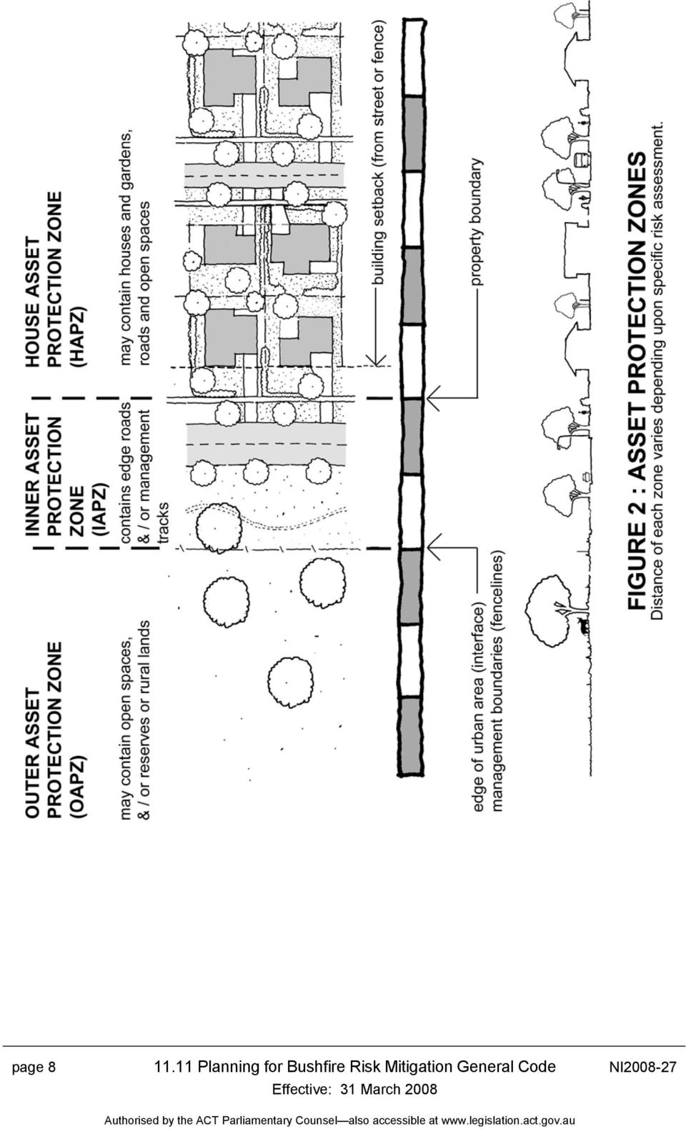
9 4. Application 4.1 New Urban Areas New urban areas are usually those identified as part of the Canberra urban area (on the Territory Plan) but have not yet been developed, such as in parts of Gungahlin, Tuggeranong, West Belconnen. As part of the planning process, a number of steps are undertaken before land is released and developed. These are: Structure Plan - broadly sets the Territory Plan s policy and principles of the area; Concept Plan - defines the specific planning framework and requirements for the area; and Estate Development Plan - details the subdivision design and lodged as a Development Application. The Authority requires all new urban areas to achieve adequate levels of bushfire protection. This can be achieved through a range of measures including the spatial and structural design of the estate, the building standards and infrastructure provision and the design of the landscape within publicly owned areas Bushfire Risk Assessment A bushfire risk assessment is required at the Structure Planning and/or Concept Planning stage, as one of many investigations undertaken to inform the planning outcome for an area. The assessment is undertaken using the Australian Standard For Risk Management AS/NZS 4360 and AS 3959 and is based on the process outlined in the NSW Planning for Bushfire Protection (2001) Document. This assessment determines the level of bushfire risk from ember attack, radiant heat and flame contact. The assessment specifically considers the following matters: the SBMP and shared responsibility; site specific bushfire and environmental data; slope, terrain and vegetation; opportunities and constraints analysis of the area; flora and fauna conservation requirements; development shape and urban interface treatments; edge roads and access network for Emergency Services vehicles (including turning/passing areas for fire trails); infrastructure (water and power supply) with adequacy at the urban interface for peak emergency demand; cost and effectiveness of risk management options; page 5

10 land management regimes in the area adjacent to urban development and its suitability for fuel reduction; Asset Protection Zones (Inner, Outer and Home); identification of planning, engineering and construction controls; staging of development and the incremental urban edge; interim protection measures / land management before and during development; and intended public realm (landscape) management requirements post development. In addition, a further Bushfire Risk Assessment may also be required at the Estate Development Plan (detail subdivision) stage to further refine and confirm any site specific requirements identified in the Concept Plan to be imposed on development Approvals Where the Bushfire Risk Assessment is part of a Structure or Concept Plan, the assessment and its recommendations are required to be endorsed by the Authority, the Emergency Services Authority (ESA) and any other relevant Government Agency. If the Bushfire Risk Assessment is part of the Estate Development Plan, the assessment and its recommendations are referred to the Emergency Services Authority for comment, ahead of the development application being determined by the Authority. Risk mitigations measures, including higher building standards, may be imposed on development through lease and development conditions or a condition of development approval Site Specific Requirements In recent times a number of bushfire risk assessments have been completed for new urban areas using the requirements of this Code. As a guide, the following describes the location and aims for Asset Protection Zones (Refer Figure 2), divisions of the urban edge for both urban planning and management purposes. The Outer Asset Protection Zone is usually non-urban land such as nature reserve or grazing land, it is farthest away from homes and built assets. Fire fuel reduction measures are to be taken to reduce fire intensity and the availability of embers that may transported into urban areas during a fire event. The Inner Asset Protection Zone is usually road reserve, parkland or nature reserve, and extends away from property boundaries. Fire fuels are to be maintained at low levels to reduce fire intensity so as to contribute to the defensible space for home-owners and emergency service efforts to minimise the ignition and ongoing combustion of homes and other structures during a bushfire. page 6
 stage to further refine and confirm any site specific requirements identified")
11 2 starts The Home Asset Protection Z1F at the property boundary front or back and may extend over a number of properties within the suburb. Buildings in this Zone may be required to be constructed to higher standards in accordance with the Building Code of Australia. Landscape (including private gardens) should be designed and regularly maintained to minimise the possibility of ignition and ongoing combustion of buildings, structures and materials during a bushfire and ensure that homeowners and emergency services have the greatest chance of assisting in such an event. The following are examples of risk management options, which have been incorporated into the concept plans and are likely to be required in new urban areas. Higher residential design and construction standards (minimum level 1 BCA) to be applied through lease and development conditions to buildings within first 100m of the Home Asset Protection Zone to mitigate against ember attack. Water Supply infrastructure to agreed capacity levels in the form of a ring main with greater provision of fire hydrants within the Inner Asset Protection Zone as well as adjacent urban area and provision for emergency vehicle (tanker) hardstand at hydrants. Emergency Access should be provided in the form of an out ring road or fire trail and access points which together with an edge road has a sealed width of 7.5m plus kerbs, indented parallel parking provision and a minimum hardstand area on the hazard side of 1.5m clear of retaining walls or stone pitched batters for passing of two emergency tankers. An additional clearance of 0.5m on both sides of the road is required to be kept clear of all street furniture including signs. Verge width to residential blocks a minimum of approximately 7m with dryland grass surface. Street trees species selected for low bark flammability characteristics. 2 The Home Asset Protection Zone is an ACT requirement and is not used in NSW. page 7

12 page 8
13 4.2 Outside the Urban Area Areas outside the defined urban area (non-urban) of the ACT were declared Bushfire Prone on 1 September 2004, this includes bushland and agricultural (rural) areas (refer Figure 1). All new Class 1, 2 and 3 buildings (i.e. new buildings, extensions and alterations creating new Class 1, 2 and 3 areas) are required to be designed and constructed to reduce the risk of ignition from a bushfire while the fire front passes. To determine the level of risk and required mitigation measures, a bushfire risk assessment is required in accordance with the BCA, consistent with AS3559, and the completed building work must comply with the BCA. In addition, a risk assessment is also required to be undertaken where the aggregated volume of the proposed alteration and any other alteration made to the Class 1, 2 and 3 building during the 3 years immediately before the day of the application for building approval of the alteration is made is more than 50% of the volume of the original building, where volume is measured by reference to roof and the outer walls. Definitions of Class 1, 2 and 3 Buildings are located at Appendix A. Design and construction of other built assets and their surrounds are recommended to be in a firewise manner Approvals The bushfire risk assessment and its recommendations is required to be lodged with the Development Application (DA) for Class 1, 2 and 3 buildings together with any mitigation measures to the design and construction of the landscape (surrounds). Following development approval, all documentation is required to be forwarded by the proponent to the certifier for building approval, consistent with the provisions of the BCA. 4.3 Existing Urban Areas Whilst no existing urban area within Canberra is declared a Bushfire Prone Area, it is recommended that the threat posed by bushfires be considered in any redevelopment of an existing property or extension to an existing house. To assist the community, two FIREWISE information brochures have been prepared outlining techniques to reduce the risk to homes and gardens. Bushfire Hazard Maps have been prepared for the existing urban edge showing a relative risk assessment current in The existing urban edge is classified according to the potential exposure to bushfire risk as primary, secondary or lee risk levels. page 9

14 Figure 3: Bushfire Hazard Map risk categories at urban edge shown with lines primary (solid), secondary (long dash) and lee (short dash) The Authority recommends that property within 100 metres of the primary and 50 metres of the secondary classification include bushfire risk mitigation measures as part of considerations and development application (DA) for redevelopment or extension. Such voluntary measures are to reduce the probability of house ignition and fire propagation by ember, radiant heat or flame contact. Depending on the type of development (for example residential accommodation for institutional uses) and its location within the existing urban area, a Bushfire Risk Assessment may be required by the Authority as part of the planning process or Development Application process. If this is required the bushfire risk assessment is to be undertaken as for new urban areas. page 10
 and its location within the existing urban area, a Bushfire Risk Assessment may be required by the")
15 Building Code of Australia Building Definitions APPENDIX A Class 1 One or more buildings, which in association constitute: (a) Class 1a - a single dwelling being: (i) a detached house; or (ii) one or more attached dwellings, each being a building, separated by a fire-resisting wall, including a row house, terrace house, town house or villa unit; or (b) Class 1b - a boarding house, guest house, hostel or the like with a total floor area not exceeding 300 m2 and in which not more than 12 persons would ordinarily be resident; which is not located above or below another dwelling or another Class of building other than a private garage. Class 2 A building containing 2 or more sole-occupancy units each being a separate dwelling. Class 3 A residential building, other than a building of Class 1 or 2, which is a common place of long term or transient living for a number of unrelated persons, including: (a) a boarding-house, guest house, hostel, lodging-house or backpackers accommodation; or (b) a residential part of a hotel or motel; or (c) a residential part of a school; or (d) accommodation for the aged, children or people with disabilities; or (e) a residential part of a health-care building which accommodates members of staff; or (f) a residential part of a detention centre. page 11

16 APPENDIX B Information from Planning for Bushfire Protection, Planning NSW, 2001 The following Table (A3.3) is from the NSW equivalent (Planning for Bushfire Protection, Planning NSW, 2001) of this Code and is provided as a guide in determining bushfire risk. This information does not negate the need for a site specific bushfire risk assessment. page 12

17 Further Reading APPENDIX C The following brochures have been prepared to assist the community Firewise Home Gardens (ACT Government) Firewise Home Design and Construction (ACT Government) These brochures are available from the ACT Planning and Land Authority, its web site (13Hwww.actpla.act.gov.au) and are also distributed by the ACT Fire Brigade through their community programs. The following list of useful references will assist in understanding planning for bushfire risk mitigation. Strategic Bushfire Management Plan for the ACT Version 1, Emergency Services Authority, ACT Government, January This is available through the web site Planning for Bushfire Protection, A Guide for Councils, Planners, Fire Authorities, Developers and home Owners, 2001, produced by NSW Rural Fire Service in collaboration with Planning NSW. Bushfires and the Bush Capital, A Guide for the ACT, October 2004, ACT Government. Landscape and Building Design for Bushfire Areas, Caird Ramsay and Lisle Rudolph, 2003, CSIRO publishing. The Bushfire Hazard Maps of existing urban edge can be viewed at the ACT Planning and Land Authority or at the Emergency Services Authority upon request. page 13

TEMPORARY ACCOMMODATION
 INTRODUCTION The City of Vincent is situated within close proximity to the Perth Central Business District, public transport networks, tourist attractions and education facilities. As such, it is well
NSW Housing Code A guide to complying development
 NSW Housing Code A guide to complying development A Guide to Complying Development: Housing Code State of New South Wales through the NSW Department of Planning April 011 Disclaimer: While every reasonable
Initially 2 zones (adjacent & extended) established in the 2005 CWPP, Modification to improve planning integration made in 2010.
 established in the 2005 CWPP, Modification to improve planning integration made in 2010.") 4) Fire Risk Mitigation Strategies This section is divided into four areas of focus. Mitigation strategies are prioritized by zone, with the highest priority being the structure ignition zone and working
4) Fire Risk Mitigation Strategies This section is divided into four areas of focus. Mitigation strategies are prioritized by zone, with the highest priority being the structure ignition zone and working
Landscaping with Ornamental Trees and Exterior Structure Features Using EcoSmart Fire Model
 Landscaping with Ornamental Trees and Exterior Structure Features Using EcoSmart Fire Model Mark A. Dietenberger, Ph.D., USDA, FS, Forest Products Laboratory, Madison, Wisconsin, USA, mdietenberger@fs.fed.us
Dwelling house guide
 Dwelling house guide Contents 1.0 Introduction... 1 2.0 What is a dwelling house?... 1 3.0 What building assessment provisions apply to dwelling houses?... 1 4.0 What level of assessment applies to a dwelling
What you need to know about. Smoke alarms for residential buildings
 What you need to know about Smoke alarms for residential buildings Are s compulsory? Smoke alarms are compulsory and must be installed in residential buildings on or near the ceiling of every storey. What
6. NATURAL AREAS FIRE MANAGEMENT
 6. NATURAL AREAS FIRE MANAGEMENT 6-1 Wildfire management is an important component of managing and maintaining County natural areas. The natural areas are woven into the community fabric and are a part
5. Financial requirements The relevant financial requirements in the board s policies.
 BUILDER RESTRICTED TO STRUCTURAL LANDSCAPING 1. Scope of work (1) Prepare, fabricate and erect carports, decking, fences, gates, gazebos, ornamental structures, pergolas, ponds and water features, prefabricated
Department for Communities and Local Government
 Department for Communities and Local Government Permitted development for householders Technical Guidance April 2014 Department for Communities and Local Government Please note: This technical guidance
WorkSafe Guidance Document FALL PROTECTION IN RESIDENTIAL CONSTRUCTION
 WorkSafe Guidance Document FALL PROTECTION IN RESIDENTIAL CONSTRUCTION WorkSafe Guidance Document Fall Protection in Residential Construction Table of Contents Executive Summary... 1 Introduction... 1
Rural dwellings including bed and breakfast accommodation
 MORNINGTON PENINSULA SHIRE COUNCIL - INTERIM POLICY - JUNE 2011 Rural dwellings including bed and breakfast accommodation This policy applies to the use and development of land for a dwelling, including
HOW TO SET UP A CHILD CARE CENTRE IN MOSMAN
 HOW TO SET UP A CHILD CARE CENTRE IN MOSMAN Mosman Municipal Council CONTENTS WHAT IS A CHILD CARE CENTRE?...3 WHERE ARE CHILD CARE CENTRES PERMISSIBLE?...3 Site Selection... 3 Size... 3 Impact on Neighbours...
Department of State Development, Infrastructure and Planning. State Planning Policy state interest guideline. State transport infrastructure
 Department of State Development, Infrastructure and Planning State Planning Policy state interest guideline State transport infrastructure July 2014 Great state. Great opportunity. Preface Using this state
2.50 Retirement villages - section 32 evaluation for the Proposed Auckland Unitary Plan
 2.50 Retirement villages - section 32 evaluation for the Proposed Auckland Unitary Plan 1 OVERVIEW AND PURPOSE...2 1.1 Subject Matter of this Section...2 1.2 Resource Management Issue to be Addressed...2
Bushfire risk perception: a study of the perceived vulnerability of domestic architecture in bushfire prone areas
 BUSHFIRE CRC LTD 2012 Small Underground Wall facing windows anticipated rooms with protective with bushfire courtyard overhang threat access direction placed which at constructed can the be wall safeguarded
FIRE INSURANCE AVAILABILITY IN HIGH RISK AREAS
 Lead Committee: Transaction and Regulatory Committee Information Committee: Land Use and Environmental Committee Level of Government Committee: Legislative Committee 09/24/13 FIRE INSURANCE AVAILABILITY
Ai Group Submission. in response to the. ACCC Consultation on Evaporative Air Conditioners in Bushfire Prone Zones
 Ai Group Submission in response to the ACCC Consultation on Evaporative Air Conditioners in Bushfire Prone Zones May 2012 EXECUTIVE SUMMARY The Australian Industry Group (Ai Group) welcomes the opportunity
Practice Note 2014-62
 Practice Note 2014-62 Documentation Required for Applications for Building Permits Reference to the Building Code of Australia (BCA) in this Practice Note means Volume One and Volume Two of the National
Section 13 Urban Residential Zones
 Section 13 Urban Residential Zones 13.1 RU1 Large Lot Housing RU1c Large Lot Housing with Carriage House RU1h Large Lot Housing (Hillside Area) RU1hc Large Lot Housing (Hillside Area) with Carriage House
Planning for bushfire risk in a changing climate: Ku-ring-gai Council action
 Council Name Web Address Size Planning for bushfire risk in a changing climate: Ku-ring-gai Council www.kmc.nsw.gov.au 82 sq. km Population 101,083 (2006) Awards 1. Background 1.1 Council profile Ku-ring-gai
House Code. House Code
 1 Application This Code will apply in assessing material change of use and/or building work for a house. 2 Using this Code In using this Code reference should also be made to Section 1.1 How to use the
fire separating walls #2
 210108 fire separating walls #2 ISSUE BSA has identified a number of instances of defective fire separating walls in duplexes, town houses and multi-residential complexes. The system of fire separating
Exempted Development - Frequently Asked Questions
 Exempted Development - Frequently Asked Questions Important Pre-Conditions Please note all exempted development is subject to certain restrictions as set out in Articles 6, 7, 8, 9 and 10 of the Regulations.
In addition to the terms defined in this By-law, the following terms shall have the corresponding meanings for the purposes of this Section:
 Click here to access definitions SECTION 12 FLOODPLAIN LANDS 12.1 INTERPRETATION In addition to the terms defined in this By-law, the following terms shall have the corresponding meanings for the purposes
Walsall Council Validation Guide for submitting a Householder Planning Application
 Walsall Council Validation Guide for submitting a Householder Planning Application Householder Planning Application Guide Introduction This guide offers help to people who are submitting a Householder
PLANNING POLICY 3.3.5
 PLANNING POLICY 3.3.5 CHILD CARE PREMISES 1. Introduction A Child Care Premises is used to provide a child care service within the meaning of the Child Care Services Act 2007, but does not include a Family
Format for scrutinising the Hill Station Building Applications ( Current File No. 24911/2001-HSBA) The application shall be accompanied by
 The application shall be accompanied by") Format for scrutinising the Hill Station Building Applications ( Current File No. 24911/2001-HSBA) 1 2 3 4 5 I. Tamil Nadu Districts Municipalities (Hill Stations) Building Rules 1993. Rules Required Available
Format for scrutinising the Hill Station Building Applications ( Current File No. 24911/2001-HSBA) 1 2 3 4 5 I. Tamil Nadu Districts Municipalities (Hill Stations) Building Rules 1993. Rules Required Available
My friends and neighbors refer to the cabin as the Miracle Cabin because it has survived two wildfires.
 & Insurance Wildfire is a growing threat in the Rocky Mountain Region, where the population is booming in the mountains and foothills. People often don t realize the dangers of living in the Red Zone (dangerous
Arts Revitalisation Projects and the Planning System. January 2010 Guideline
 Arts Revitalisation Projects and the Planning System January 2010 Guideline Photography credits: courtesy http://www.flickr.com/groups/renewnewcastle/ Arts Revitalisation Projects and the Planning System
Guidance on Householder permitted development rights
 FORWARD CONTENTS CLOSE Guidance on Householder permitted development rights Circular 1/2012 CONTENTS BACK FORWARD CLOSE 1. INTRODUCTION 04 2. BEFORE STARTING 05 3. MAIN CONCEPTS 07 Principal elevation
Caravan Park FIRE SAFETY
 Caravan Park FIRE SAFETY PUBLISHED MAY 2012 Contents Foreword 2 Introduction 3 Definitions 5 Background 8 Key stakeholder responsibilities 9 Guideline structure 10 Application of the guideline 12 Alternative
Heritage Place Code. Heritage Place Code
 1 Application This Code will apply in assessing building work (including demolition), reconfiguring a lot or operational work where: on a premises that includes a heritage place within a heritage precinct
AS 4708:2013. Interpretation of Requirements relating to the Recovery of Forest Products from a Water Body
 AS 4708:2013 Interpretation of Requirements relating to the Recovery of Forest Products from a Water Body BACKGROUND Australian Forestry Standard Limited has been asked for an interpretation of the Australian
Bushfire Risk Management Planning. Guidelines for Preparing a Bushfire Risk Management Plan
 Bushfire Risk Management Planning Guidelines for Preparing a Bushfire Risk Management Plan November 2015 Department of Fire and Emergency Services 2015 Other than permitted under the Copyright Act 1968,
The National Wildfire Mitigation Programs Database: State, County, and Local Efforts to Reduce Wildfire Risk 1
 Proceedings of the Second International Symposium on Fire Economics, Planning, and Policy: A Global View The National Wildfire Mitigation Programs Database: State, County, and Local Efforts to Reduce Wildfire
PROTECTING YOUR HOME FROM WILDFIRE
 PROTECTING YOUR HOME FROM WILDFIRE Protecting your future for 150 years PROACTIVE PREPARATION CAN SPARE YOUR HOME FROM DESTRUCTION. PROTECTING YOUR HOME FROM WILDFIRE Wildfire losses have greatly increased
Aztech Architecture Your Guide to Overshadowing, Daylight & Sunlight. 1 P age
 Aztech Architecture Your Guide to Overshadowing, Daylight & Sunlight 1 P age Welcome Sometimes people fear they may suffer a loss of daylight or sunlight if their homes and gardens are overshadowed by
CITY OF VAUGHAN SCHEDULE O LOT GRADING DESIGN FOR RESIDENTIAL DEVELOPMENT
 Page 1 CITY OF VAUGHAN SCHEDULE O LOT GRADING DESIGN FOR RESIDENTIAL DEVELOPMENT CIVIC CENTRE 2141 MAJOR MACKENZIE DRIVE MAPLE ONTARIO L6A 1T1 905-832-2281 Page 2 SECTION 1 - GENERAL OBJECTIVES To provide
DESIGN GUIDANCE NOTE: 11 PORCHES
 DESIGN GUIDANCE NOTE: 11 PORCHES 1. INTRODUCTION This guidance note is one of a series giving advice on various types of development within Barnet. It advises on designing porch extensions including canopies.
CHAPTER 5 - "R1" SINGLE-FAMILY RESIDENTIAL DISTRICT
 CHAPTER 5 - "R1" SINGLE-FAMILY RESIDENTIAL DISTRICT Section 5-1. Regulations: The regulations set forth in this chapter, or set forth elsewhere in this ordinance when referred to in this chapter, are the
Site and Storage Conditions for Class 3.1 Flammable Liquids
 Site and Storage Conditions for Class 3.1 Flammable Liquids Introduction Contents Introduction... 1 SITE AND STORAGE CONDITIONS...2 Part 1 General Flammability Conditions...2 Part 2 Conditions Relating
sdci Seattle Permits Tip Tree Protection Regulations in Seattle CATEGORIES OF TREES AFFECTED IDENTIFYING TREE TYPES ON YOUR PROPERTY
 sdci Seattle Department of Construction and Inspections Tip 242 Seattle Permits part of a multi-departmental City of Seattle series on getting a permit Updated May 12, 2011 Tree Protection Regulations
State Records Guidelines No 23. Certification for Places of Deposit of State archives
 State Records Guidelines No 23 Certification for Places of Deposit of State archives Issued: August 2013 Table of Contents 1 Introduction... 4 1.1 Purpose... 4 1.2 Authority... 4 2 Certification... 4 3
DEVELOPMENT BRIEF FOR LAND AT ALLOA ROAD, TULLIBODY
 DEVELOPMENT BRIEF FOR LAND AT ALLOA ROAD, TULLIBODY 1.0 Introduction and Purpose 1.1 Clackmannanshire Council is seeking to dispose of a site at Alloa Road, Tullibody for redevelopment. The site extends
ENERGY, MINES AND RESOURCES (EMR) ASSESSMENT REGULATORY GUIDE:
 ASSESSMENT REGULATORY GUIDE:") Energy, Mines and Resources Energy, Mines and Resources Energy, Mines and Resources Energy, Mines and Resources ENERGY, MINES AND RESOURCES (EMR) ASSESSMENT REGULATORY GUIDE: A guide to explain how EMR
Energy, Mines and Resources Energy, Mines and Resources Energy, Mines and Resources Energy, Mines and Resources ENERGY, MINES AND RESOURCES (EMR) ASSESSMENT REGULATORY GUIDE: A guide to explain how EMR
4 Alternatives and Design Evolution
 4 Introduction 4.1 This Chapter describes the considerations and constraints influencing the siting, layout and massing of the Development. It also describes the main alternatives to the Development that
Tree Management Policy
 Kingston District Council WE002 Tree Management Policy Keywords: Reference Number: WE002 Strategic Plan: Classification: Works & Engineering Policy First Issued/Approved: 2011 Review Frequency: Every 4
Smoke Alarms. New smoke alarm requirements for existing buildings from 1 May 2006. Introduction. Advisory note March 2006
 New smoke alarm requirements for existing buildings from 1 May 2006 Advisory note March 2006 Introduction To enhance safety and minimise loss-of-life in building fires, the NSW Parliament, in July last
3.0 Table of Development Note: This table must be read in conjunction with the explanation provided in Part 5, Division 1, Chapter 2 Using Domains.
 Part 5 Division 2 Chapter 2 Domains Domains Park Living 1.0 Intent The purpose of this domain is to provide a variety of opportunities for low density residential activity within areas of semi-rural landscapes,
Trees, powerlines and your property
 Your safety and responsibility Trees, powerlines and your property Tree clearing Victoria has well earned the reputation as the Garden State. It s in everyone s interest to help manage the growth and health
28.0 Development Permit Area #2 (Neighbourhood District)
") 28.0 Development Permit Area #2 (Neighbourhood District) Goals and Objectives To provide a guide for infill and new development in the Neighbourhood District. To outline the nature, form and character
28.0 Development Permit Area #2 (Neighbourhood District) Goals and Objectives To provide a guide for infill and new development in the Neighbourhood District. To outline the nature, form and character
Building Permit Information House Relocation
 Building Permit Information House Relocation About private Building Surveyors Until about 1992 all building permits were issued by Councils. This function was then privatised, and while many Councils still
SANTA BARBARA COUNTY COMPREHENSIVE PLAN LOMPOC AREA
 SANTA BARBARA COUNTY COMPREHENSIVE PLAN LOMPOC AREA A. LAND USE ELEMENT INTERPRETIVE GUIDELINES B. COMMUNITY BENEFITS C. COUNTY ACTION ITEMS Adopted by the Board of Supervisors November 9, 1999 A. Santa
Summary: Introduction
 Summary: Melbourne Water has a range of responsibilities in the Port Phillip and Westernport region, including responsibilities for the protection and restoration of waterways and, in collaboration with
Fire or Ignition Resistant? Building Materials & Vegetation
 Fire or Ignition Resistant? Building Materials & Vegetation Steve Quarles, IBHS & Pat Durland, Stone Creek Fire, LLC 2011 Backyards & Beyond Wildland Fire Education Conference Denver, Colorado October
Use of Decision Support Tools for Bushfire Risk Management in NSW
 Use of Decision Support Tools for Bushfire Risk Management in NSW Presented by Stuart Midgley Director of Risk Management Performance NSW Rural Fire Service Definition Decision support tools or decision
11.4 Voluntary Purchase. 11.5 House Raising and Flood Proofing
 11.4 Voluntary Purchase As mentioned in Section 10 in certain high hazard areas of the floodplain, it may be impractical or uneconomic to mitigate flood hazard to existing properties at risk, or flood
MOUNT BARKER (DC) DEVELOPMENT PLAN
 DEVELOPMENT PLAN") Mount Development Plan Amendment MOUNT BARKER (DC) DEVELOPMENT PLAN SIGNIFICANT TREES DPA Development Plan Amendment by the Council For Consultation May 2008 Page intentionally left blank Development Plan
Mount Development Plan Amendment MOUNT BARKER (DC) DEVELOPMENT PLAN SIGNIFICANT TREES DPA Development Plan Amendment by the Council For Consultation May 2008 Page intentionally left blank Development Plan
BUILDING OR RENOVATING
 A GUIDE TO BUILDING OR RENOVATING YOUR IDEAL HOME building work? What records should I keep? Is insurance required? W I need approval for? What do I need approval for? How do I obtain building work? How
Public Landscape Aids And Protection Of Assets
 Territory and Municipal Services Reference Document 4 LANDSCAPE MANAGEMENT AND PROTECTION PLANS (LMPP) Requirements for the Protection of Public Landscape Assets Adjacent to Development Works Issue 2 Revision
CITY OF SUBIACO. PLANNING POLICY 1.4 (September 2013) PUBLIC NOTIFICATION OF PLANNING PROPOSALS
 PUBLIC NOTIFICATION OF PLANNING PROPOSALS") CITY OF SUBIACO PLANNING POLICY 1.4 (September 2013) PUBLIC NOTIFICATION OF PLANNING PROPOSALS ADOPTION DATE: to be inserted AUTHORITY: TOWN PLANNING SCHEME NO. 4 STATE PLANNING POLICY 3.1 RESIDENTIAL
CITY OF SUBIACO PLANNING POLICY 1.4 (September 2013) PUBLIC NOTIFICATION OF PLANNING PROPOSALS ADOPTION DATE: to be inserted AUTHORITY: TOWN PLANNING SCHEME NO. 4 STATE PLANNING POLICY 3.1 RESIDENTIAL
Part F South East Queensland Regional Plan 2009 2031 State planning regulatory provisions
 Part F South East Queensland Regional Plan 2009 2031 State planning regulatory provisions 159 Part F South East Queensland Regional Plan 2009 2031 State planning regulatory provisions 160 South East Queensland
66 REFERRAL AND NOTICE PROVISIONS. Scope
 66 REFERRAL AND NOTICE PROVISIONS 29/10/2015 VC101 Scope These provisions set out the types of applications which must be referred under Section 55 of the Act or for which notice must be given under Section
WATER INDUSTRY ACT 2012. South Australian Water Heater Installation Requirements. Prepared by the Technical Regulator
 WATER INDUSTRY ACT 2012 South Australian Water Heater Installation Requirements Prepared by the Technical Regulator Installation requirements for water heaters serving established Class 1A buildings, established
B. Improve the appearance and character of areas surrounding new development.
 Chapter 4.3: Landscape Regulations Sections: 4.301 Purposes 4.302 Applicability 4.303 General Provisions 4.304 Landscape Maintenance 4.301 Purposes The purposes of these regulations are to: A. Promote
Queens Park. Revised Draft Master Plan
 Queens Park Nature-Based Accommodation Revised Draft Master Plan Disclaimer This publication may be of assistance to you but the Great Ocean Road Coast Committee do not guarantee that it is without flaw
6 Streetscape character 6.1
 6 6.1 6 Streetscape character Introduction Transport interchanges The TLRN is the strategic road network for London and varies in character across the capital. The variation of the land use across London
Chapter 7 ZONING PLAN
 Chapter 7 ZONING PLAN Introduction This Chapter opens with a general description of a zoning plan. It is followed by a brief explanation of the relationship between this Growth Management Plan and the
BUILDING AND DEVELOPMENT TRIBUNAL - DECISION
 APPEAL File No. Insert No. 3-06-004 Integrated Planning Act 1997 BUILDING AND DEVELOPMENT TRIBUNAL - DECISION Assessment Manager: Site Address: Gold Coast City Council withheld- the subject site Applicant:
monitor You Too Can Prevent Wildfires Smokey Bear Turned 65! the Environmental
 Published quarterly by the Association of Environmental Professionals NAEP Affiliation monitor the Environmental Fall 2010 You Too Can Prevent Wildfires Smokey Bear Turned 65! 2011 AEP Award Submittal
IGNITION-RESISTANT CONSTRUCTION: THE WHY BEHIND THE WHAT
 IGNITION-RESISTANT CONSTRUCTION: THE WHY BEHIND THE WHAT WHAT IS THE RATIONALE BEHIND THE REQUIREMENTS FOR IGNITION RESISTANT CONSTRUCTION? The wildfires of 2003 and 2007 were the largest in California
Development Type - Retirement Accommodation
 Retirement Accommodation Introduction Australia has an ageing population and by 2056 up to one quarter of Australia s population will be aged 65 or older. Australia's population, like that of most developed
PERMISSION A GUIDE FOR EXTENDING A DETACHED OR SEMI-DETACHED HOUSE
 PLANNING PERMISSION A GUIDE FOR EXTENDING A DETACHED OR SEMI-DETACHED HOUSE Introduction Foreword by Councilor Dave Smith - Chair of the Planning & Highways Committee. Planning Permissions B Owners of
DRAFT POLICIES COUNTY OF HALIBURTON OFFICIAL PLAN UPDATE
 SETTLEMENT AREAS Introduction Urban Serviced DRAFT POLICIES These urban areas have either full or partial primary urban services, mainly water, sewage and roads. Functionally, they tend to service larger
APPENDIX G. California Coastal Commission & Conservancy Accessibility Standards
 APPENDIX G California Coastal Commission & Conservancy Accessibility Standards STANDARDS AND RECOMMENDATIONS FOR ACCESSWAY LOCATION AND DEVELOPMENT These standards provide guidelines for the location,
Ministry of the Environment Decree. on housing design
 G1 THE NATIONAL BUILDING CODE OF FINLAND Housing Design Regulations and Guidelines 2005 Ministry of the Environment Decree on housing design adopted in Helsinki on the 1 st of October 2004 In accordance
APPENDIX 4. Risk Tables
 APPENDIX 4 Tables Preliminary Qualitative Criteria The qualitative risk assessment criteria have been developed to identify key risks to the environment, society, heritage and business reputation. The
10.1 WILL HEY FARM WATFORD LANE NEW MILLS RETENSION OF NEW STABLE BLOCK, SAND PADDOCK AND ASSOCIATED EARTHWORKS AND LANDSCAPING (FULL - MINOR)
") HPK/2012/0207 03/04/2012 WILL HEY FARM WATFORD LANE NEW MILLS MR & MRS M WILSON KIRSTY WILSON EQUINE AND WILL HEY FARM BED & BREAKFAST RETENSION OF NEW STABLE BLOCK, SAND PADDOCK AND ASSOCIATED EARTHWORKS
HPK/2012/0207 03/04/2012 WILL HEY FARM WATFORD LANE NEW MILLS MR & MRS M WILSON KIRSTY WILSON EQUINE AND WILL HEY FARM BED & BREAKFAST RETENSION OF NEW STABLE BLOCK, SAND PADDOCK AND ASSOCIATED EARTHWORKS
The Importance of Garbage Clearing and vegetation
 BHFD Fire Prevention Bureau 445 North Rexford Drive Beverly Hills, CA 90210 2014 BEVERLY HILLS FIRE DEPARTMENT Beverly Hills Fire Department BRUSH CLEARANCE PROGRAM INFORMATION BROCHURE Your property is
Rezoning case no. RZ15-08: Adam Development Properties, LP
 PLANNING AND ZONING COMMISSION STAFF REPORT June 4, 2015 Rezoning case no. RZ15-08: Adam Development Properties, LP CASE DESCRIPTION: LOCATION: a request to amend the development plan of a previously-approved
Building in the ACT. A consumer guide to the building process OCTOBER 2014
 Building in the ACT A consumer guide to the building process OCTOBER 2014 Australian Capital Territory, Canberra 2014 This work is copyright. Apart from any use as permitted under the Copyright Act 1968,
Council Policy for New Telecommunication Facilities
 Council Policy for New Telecommunication Facilities 1. Purpose To establish policies and procedures for the installation of new telecommunication antennas, towers and related structures which emphasize
Draft New Museums Site Development Framework Supplementary Planning Document SUSTAINABILITY APPRAISAL SCREENING REPORT
 Draft New Museums Site Development Framework Supplementary Planning Document SUSTAINABILITY APPRAISAL SCREENING REPORT MAY 2015 1 Contents 1 INTRODUCTION 3 2 DRAFT NEW MUSEUMS SITE SPD 4 3 STRATEGIC ENVIRONMENTAL
Design Essentials. Stockland Residential Communities 1 st January 2014
 Design Essentials Stockland Residential Communities 1 st January 2014 WELCOME TO THE DESIGN ESSENTIALS The Design Essentials form part of your Contract of Sale and assist when designing your home and landscape.
Householder Applications: Supplementary Planning Guidance GENERAL POINTS
 Householder Applications: Supplementary Planning Guidance Environment Committee: 28 January 2004 Chief Planning Officer Town Hall The Parade Epsom Surrey KT18 5BY tel 01372 732000 web www.epsom-ewell.gov.uk
Control filling, grading, dredging, and other development which may increase erosion or flood damage; and
 ARTICLE 16. FLOOD DAMAGE PREVENTION Section 16-1: Findings of Fact The flood hazard areas of the Town of Lillington are subject to periodic inundation which results in loss of life and property, health
Property Development Connection Requirements (Water)
") GUIDELINES Property Development Connection Requirements (Water) 1. Purpose These guidelines apply to developed property and define: (a) (b) (c) (d) what is a satisfactory point of connection; what works
GUIDELINES Property Development Connection Requirements (Water) 1. Purpose These guidelines apply to developed property and define: (a) (b) (c) (d) what is a satisfactory point of connection; what works
Frequently-Asked Questions about Floodplains and Flood Insurance FLOOD INSURANCE
 Frequently-Asked Questions about Floodplains and Flood Insurance What is a floodplain? The floodplain is any area covered by water during normal water flows, and which could be inundated as a result of
Development Brief for New Lodge, Bank Mill Lane Berkhamsted. Adopted November 2007
 Development Brief for New Lodge, Bank Mill Lane Berkhamsted Adopted November 2007 This publication seeks your opinions about the design, layout and requirements for new housing development at New Lodge,
9 Fire and ambulance services
 9 Fire and ambulance services CONTENTS 9.1 Profile of emergency services for fire events 9.2 9.2 Framework of performance indicators for fire events 9.5 9.3 Key performance indicator results for fire events
Kirkland Zoning Code 113.25
 Kirkland Zoning Code 113.25 Chapter 113 COTTAGE, CARRIAGE AND TWO/THREE-UNIT HOMES Sections: 113.05 User Guide 113.10 Voluntary Provisions and Intent 113.15 Housing Types Defined 113.20 Applicable Use
PLANNING APPLICATION: 12/00056/APP
 PLANNING APPLICATION: 12/00056/APP In the event that a recommendation on this planning application is overturned the Committee is reminded of the advice contained on the front page of the agenda for Reports
Advice can also be sought from specific specialist officers in the Council.
 Canterbury City Council Validation of Planning Applications Guidance note 2010: Introduction Up to date advice on the validation of planning applications is contained in the CLG Guidance on information
Kings Road, Beith. Development Brief. Part 1: Site Specific Information
 Kings Road, Beith Development Brief Part : Site Specific Information Introduction Kings Road is a greenfield site on the north west edge of Beith and is currently let for grazing. The site is roughly rectangular
CORPORATE POLICY STATEMENT NO. 12 MANAGEMENT OF PEST ANIMALS
 1. OBJECTIVE CORPORATE POLICY STATEMENT NO. 12 MANAGEMENT OF PEST ANIMALS August 2015 To provide direction and guidance for the management of pest animals on lands and waters managed by the Department
VEHICLE CROSSOVER INFORMATION PACK
 VEHICLE CROSSOVER INFORMATION PACK CONTENTS Introduction Section A Section B Section C Section D Section E Criteria for approving a vehicle crossover application (Diagrams to demonstrate measurement criteria)
SCHEDULE 2 TO THE DEVELOPMENT PLAN OVERLAY Shown on the planning scheme map as DPO2 WAVERLEY GOLF COURSE, LYSTERFIELD VALLEY
 SCHEDULE 2 TO THE DEVELOPMENT PLAN OVERLAY Shown on the planning scheme map as DPO2 WAVERLEY GOLF COURSE, LYSTERFIELD VALLEY 1.0 Conditions and requirements for permits A permit to use and develop the
Supplementary Guidance Stiùireadh Leasachail. Managing Waste in New Developments A Stiùireadh Sgudal ann an Leasachaidhean Ùra
 Supplementary Guidance Stiùireadh Leasachail Managing Waste in New Developments A Stiùireadh Sgudal ann an Leasachaidhean Ùra March 2013 Managing Waste in New Developments Supplementary Guidance Contents
CONSENT, PURSUANT TO SECTIONS 34A, 88, 104, 104C, and 108 OF THE RESOURCE MANAGEMENT ACT, IS GRANTED. THE FULL DECISION IS SET OUT BELOW
 A U C K L A N D C O U N C I L Decision following the hearing of an application for resource consent SUBJECT: Application for resource consent under section 88 of the Resource Management Act 1991 by D C
Do I need planning permission?
 Do I need planning permission? Advice for householders on house improvements on house improvements Planning Services www.leeds.gov.uk/planning What does this leaflet cover? Certain minor changes to a house