Analysis of the Water Quality of Eighteenmile Creek, Erie County, New York:
|
|
|
- Ruby Morton
- 7 years ago
- Views:
Transcription
1 Analysis of the Water Quality of Eighteenmile Creek, Erie County, New York: A Comparison of Water Quality Between 1970, 1973 and 2000 By: Kristal Lynn Krasinski Senior Student Department of Geography/Planning State University, College at Buffalo 1300 Elmwood Avenue Buffalo, NY Prepared for: Western New York Land Conservancy 21 South Grove Street, Suite 120 East Aurora, NY wnylc@wnylc.org May 2003 i dedicated to preserving the environmental heritage of Western New York

2 Major funding for the Eighteenmile Creek Water Quality Sampling Study provided by Community Foundation for Greater Buffalo Town of Eden Conservation Advisory Board Town of Evans Conservation Advisory Board Western New York Land Conservancy, Inc. Donated Services and Technical Assistance provided by Erie County Department of Health Laboratory Erie County Soil and Water Conservation District USDA Natural Resources Conservation District Town of Boston Conservation Advisory Board Town of Eden Conservation Advisory Board Town of Evans Conservation Advisory Council Western New York Land Conservancy Gerhard Paluca, Department of Health, Erie County Public Health Laboratory Kim Irvine, Department of Geography & Planning, State University Collage at Buffalo John Whitney, USDA Natural Resources Conservation Service Amy Holt, Western New York Land Conservancy John Daleo, Erie County Department of Public Health Sampling Volunteers Frank Mantione Kathy Hughes Mary Jane Bolo David Stout Mary Alice Tocke Kathy Swank Lisa Ishwardis John Szydlowski ii

3 TABLE OF CONTENTS 1. INTRODUCTION 1 2. STUDY METHOD Sample Sites Sample Collection Sample Laboratory Analysis 5 3. RESULTS AND DISCUSSION Hydrology Water Quality Total Coliforms Fecal Coliforms Biological Oxygen Demand Orthophosphates Chlorides Nitrates CONCLUSION AND RECOMMENDATIONS REFERENCES 30 APPENDIX A WATER QUALITY SAMPLE RESULTS PER SITE 31 iii

4 TABLES 2.1 Summary of Sample Sites Discharge Data Discharge Data Total Coliforms Sample Data from Each Year and Percentage Change Fecal Coliforms Sample Data from Each Year and Percentage Change Biological Oxygen Demand Sample Data from Each Year and Percentage Change Orthophosphates - Sample Data from Each Year and Percentage Change Chlorides - Sample Data from Each Year and Percentage Change Nitrates - Sample Data from Each Year and Percentage Change 25 iv

5 FIGURES 2.1 Map of Sample Site Locations, Eighteenmile Creek, NY Mean Daily Streamflow Discharge or Cazenovia Creek, NY Mean Daily Streamflow Discharge or Cazenovia Creek, NY Mean Daily Streamflow Discharge or Cazenovia Creek, NY and 2000 Total Coliform Sample Site Values Map of Site Three in Reference to Town of Hamburg and 2000 Fecal Coliform Sample Site Values , 1973 and 2000 BOD Sample Site Values , 1973 and 2000 Orthophosphates Sample Site Values and 2000 Chlorides Sample Site Values and 2000 BOD Nitrates Site Values 27 v

6 INTRODUCTION Eighteenmile Creek, Erie County, New York, flows from south to north then turns west to empty into Lake Erie (Figure 2.1). The watershed of Eighteenmile Creek includes parts of several communities including Eden, Evans, Hamburg, and Boston. The purpose of this research project is to: 1. Compare historical data to data from field samples collected in 2000 to determine if a change has occurred in the waterway and 2. Compare data from all sampling years to present day water quality sampling standards. Previous studies conducted by the Erie County Department of Health (ECDH) in 1970 and 1973 included testing for total coliforms, fecal coliforms, biological oxygen demand (BOD), orthophosphates, chlorides and nitrates. Therefore, the 2000 sample data collection concentrated on the above parameters to evaluate current water quality. The results of this study will help to describe or characterize the present state of the water quality at Eighteenmile Creek and provide information to the surrounding communities of Eden, Evans, Hamburg and Boston. 1

7 2. STUDY METHODS 2.1 Sample Sites Water samples from Eighteenmile Creek were collected at eight sites (Figure 2.1). The site locations are summarized in Table 2.1. Sample Sites three through six were located on the North Branch of the creek and sample Sites seven and eight were located on the South Branch. Sites one and two were located on the Main Branch below the convergence of the North and South Branches. The eight sites were chosen by referencing the 1970, 1973 and 1976 water quality sampling efforts undertake by the Erie County Department of Public Health (ECDPH, 1970; ECDPH, 1973; ECDPH 1976). The sample sites were not located to target specific suspected contamination source areas. The sites were instead spaced out along the creek at points of easy access to give a generalized picture of the water quality of Eighteenmile Creek. Table 2.1. Summary of Sample Sites Site No. Latitude Longitude Branch Description Municipality 1 42 o 42'44.8'' N 78 o 57'59.3'' W Main 2 42 o 41'45.1'' N 78 o 56'8.9'' W Main 3 42 o 42'24.3'' N 78 o 50'56.5'' W East 4 42 o 41'4.5'' N 78 o 46'40.3'' W East 5 42 o 37'42.4'' N 78 o 44'27.2'' W East 6 42 o 35'24.0'' N 78 o 42'15.4'' W East 7 42 o 40'36.3'' N 78 o 52'27.3'' W West 8 42 o 37'28.5'' N 78 o 50'17.2'' W West Bridge on Lake Shore Rd. near North Creek Rd. Bridge on US-20 near South Creek Rd. Bridge on US-62 Next to Water Valley Inn Bridge on Herman Hill Rd. near Back Creek Rd. Bridge on Pfarner Rd. between Route 391 and Back Creek Rd. Bridge near Springville Boston Rd. Bridge on US-62 near Jennings Rd. Bridge is near 9605 New Oregon Rd. Derby Eden Hamburg Hamburg Boston Boston Eden Eden 2

8 Figure 2.1. Map of Sample Site Locations, Eighteenmile Creek, NY Note: The color green at site one and the color red at site 8 do not represent anything unique about the sample sites. 3

9 2.2 Sample Collection The collection of the water samples for this project was conducted from April 2000 through December The samples were collected on the first Tuesday of each month. The second Tuesday of each month was used instead if the stream conditions were hazardous on the first Tuesday. The project manager was Amy Holt, Outreach Coordinator, from the Western New York Land Conservancy (WNYLC). Assisted by John Daleo of the Erie County Department of Public Health (ECDPH), volunteers were trained in sampling procedures in February of 2000 at the Water Valley Inn in Hamburg (Site three). Water sampling procedures followed accepted standard methods recommended by the American Public Health and American Water Works Association (18 th edition) (APHA, 1992). The same equipment was used at each site for water sample collection. A 300ml sterile bottle was used to collect a sample for the fecal coliform and total coliform tests. A half gallon bottle was used to for the collection of sample water for BOD, orthophosphate, nitrate and chloride tests. All samples were taken at the middle point of the deepest portion of the stream with the collector standing downstream from where the sample would be taken from. At each site the collector removed the cap and submerged each bottle one at a time with the mouth of the bottle facing upstream. The sample was collected approximately six to twelve inches below the surface. When full, the collector replaced the cap and marked each bottle with the site number. The samples were kept in a cooler and transported to the ECDPH Laboratory by noon on the sample dates. 4
, volunteers were trained in sampling procedures in February of 2000 at the Water Valley Inn in Hamburg (Site three).")
10 2.3 Laboratory Analysis At the ECDPH Laboratory, Gerhard Paluca completed the analysis of the samples. The ECDPH Laboratory is a certified New York State E Lab with the National Environmental Laboratory Accreditation Council (NELAC). The water testing methods used in the year 2000 testing procedures compare closely with the procedures used in the 1970s (ECDPH, 1970; ECDPH, 1973; ECDPH, 1976). Fecal coliform testing was performed using membrane filtration with a standard method number of 9222-D. Total coliform testing was performed using membrane filtration as well with a standard method number of 9222-B. Chlorides were tested using an argentometric test with a standard method 4500-PE. Biological oxygen demand was tested using a 5-day test method with a standard method number of 5210 B. Nitrates were tested using the FIA flow injection methodology with a standard method number of NO31. 5

11 3. RESULTS AND DISCUSSION 3.1 Hydrology The USGS gauge site at Cazenovia in Ebenezer, New York was used to gather the daily mean discharge for the sample areas of Eighteenmile Creek ( This adjacent gauge site in the Cazenovia Creek watershed was used because there was not a gauge site located in the Eighteenmile Creek watershed. Therefore all discharge values will be approximate and will be used to help identify relative dry and wet (storm) periods that would have occurred on Eighteenmile Creek. The 1970 discharge data are presented in Figure 3.1. These discharge data represent the whole year because exact dates of sample collection could not be determined (ECDPH, 1970). The 1973 discharge data are presented in Figure 3.2. These discharge data represent the period 6/17/73 through 9/7/73. The black dots represent sample dates showing the corresponding flow conditions in Cazenovia Creek when the Eighteenmile Creek samples were collected. The 2000 discharge data are presented in Figure 3.3. These discharge data represent the period of 4/1/00 through 12/1/00. Again the black dots represent the sample dates showing the corresponding flow conditions in Cazenovia Creek when the Eighteenmile Creek samples were collected. The 1973 sample dates are summarized in Table 3.1. Most samples in 1973 were collected during dry weather, inter-event flow. These Eighteenmile Creek sampling dates had values of high daily mean discharge that ranged from 13 to 35 cubic feet per second in the Cezenovia Creek watershed. There were four sample dates (6/19/73, 6/20/73, 7/3/73, and 8/1/73) that were located on the falling limb of the Cazenovia Creek hydrograph. Sample dates 6/19/73 and 6/20/73 were somewhat higher than any other sample dates on the hydrograph. They had discharges of 95 and 63 cubic feet per second, respectively. These indicate that they were at the end of a larger runoff event. Eighteenmile Creek sample date 7/25/73 occurred on a 6
.")
12 1970 Mean Daily Streamflow for Cazenovia Creek Dailystream Flow, ft 3 /s /01/ /01/ /01/ /01/ /01/ /01/ /01/ /01/ /01/ /01/ /01/ /01/1970 Date Figure Mean Daily Streamflow Discharge for Cazenovia Creek, NY. ( Mean Daily Streamflow for Cazenovia Creek Dailystream flow, ft 3 /s /19 6/20 6/27 7/2 7/10 7/18 7/25 7/24 7/31 8/1 8/8 8/15 8/21 8/28 9/4 9/5 06/01/ /15/ /29/ /13/ /27/ /10/ /24/ /07/1973 Date Figure Mean Daily Streamflow Discharge for Cazenovia Creek. The black dots represent sample dates. ( 7

13 2000 Mean Daily Steamflow for Cazenovia Creek Dailystream Flow, ft 3 /s /13 8/ /4 6/8 7/13 9/7 10/5 11/2 0 04/01/ /01/ /01/ /01/ /01/ /01/ /01/ /01/ /01/2000 Date Figure Mean Daily Streamflow Discharge for Cazenovia Creek. The black dots represent sample dates. ( The peaks of certain events in the hydrograph are cut off because I changed the axis scale. This was done so that the flow rates on the sample dates could be more easily viewed Discharge Compared to Sample Date Sample Date Discharge in ft 3 /s 06/19/ /20/ /27/ /02/ /10/ /18/ /24/ /25/ /31/ /01/ /08/ /15/ /21/ /28/ /04/ /05/ Discharge Compared to Sample Date Sample date Discharge in ft 3 /s 04/13/ /04/ /08/ /13/ /03/ /07/ /05/ /02/ Table Discharge Data Table Discharge Data 8

14 rising limb of the Cazenovia Creek hydrograph indicating that it was sampled at the beginning of the event. Only one sample date on 8/21/73 occurred at a peak on the Cazenovia Creek hydrograph, with a cubic discharge of 36 cubic feet per second. Since it was a small runoff event with inter-event periods both before and after it the flow conditions do not vary much from the other sample dates. The 2000 sample dates occurred across a variety of discharge events and had a greater variability than the 1973 samples. This is summarized in Table 3.2. Sample dates 6/8/00, 7/13/00, 9/7/00 and 11/2/00 were collected during relatively dry weather, inter-event flow. The two best examples of the dry weather, inter-event flow were sampling dates of 9/7/00 and 11/2/00 with a range of 21 to 29 cubic feet per second for the mean daily discharge in the Cazenovia Creek watershed. Sample dates 4/13/00 and 5/4/00 were located on a falling limb of the Cazenovia Creek hydrograph, with discharges of 409 and 125 cubic feet per second respectively. Eighteenmile Creek sample date 10/5/00 occurred on a rising limb of the Cazenovia Creek hydrograph suggesting that it was sampled near the beginning of an event. Sample date 8/3/00 was the only one that was collected during a peak in the Cazenovia Creek hydrograph. This had a discharge value of 710 cubic feet per second and indicated a higher flow compared to other sample dates. 9

15 3.2 Water Quality Raw data for each parameter are presented in Appendix A. Data are summarized at each site and in most cases the parameters are presented in arithmetic mean, geometric mean, median and maximum depending on the standards for which the parameter was based on Total Coliforms Total Coliforms are the combined total of coliform bacteria (including fecal coliforms) that are present in water samples (ECDPH, 1970). The New York State Department of Environmental Conservation (NYS DEC) water quality standards states that the median shall not exceed 2400/100mL and more than 20% of samples shall not exceed 5000/100mL for Class A and B streams (Gold Book, 2002). Total coliforms were measured as median values at various sites in 1973 and 2000 because that is what the water quality standards were based on (Figure 3.4). The graphs in Figure 3.4 summarize the total coliforms tested in 1973 and 2000 sampling. Table 3.3. Total Coliform - Sample Data from each Year and Percent Change Median Total Coliforms (per 100mL) by Site Year % Change from 1973 to % -28.2% % -57.1% +41.4% 10
 water quality standards states that the median shall not exceed 2400/100mL and more than 20% of samples shall not exceed")
16 There were five sites at which sampling occurred in both 1973 and 2000 (Sites: 1, 2, 3, 4, and 5). Sites two and four showed a 28.2 to 57.1 percent decrease in the median values of total coliforms from 1973 to 2000 (Table 3.3). Sites one, three and five showed a 41.4 to percent increase in the median values of total coliforms (Table 3.3). Although there was an increase, the values still did not exceed the NYS DEC water quality standard of 2400/100mL (Gold Book, 2002). Site three had the largest increase at percent from 1973 to 2000 (Table 3.3). This increase could be related to Site three s proximity to the Village of Hamburg. Site three is downstream from the Village of Hamburg and is located in a small valley before the creek moves westward (Figure 3.5). Therefore it is likely that most of the runoff from the Village of Hamburg will enter the creek near this location increasing total coliform levels in the vicinity of Site three. Site one, which is a Class B stream, did not meet the second part of the NYS DEC standard that requires that 20 percent of samples shall not exceed 5,000/100mL (Gold Book, 2002). Testing done on 8/3/00 and 10/5/00 revealed total coliform at 10,000/100mL and 6,000/100mL, respectively. Therefore of eight samples collected at site one, 25 percent of the samples exceeded the 5,000/100mL limit. Both of these sample dates had high discharge values therefore indicating a storm event near the time of sampling. Since site one is located at the mouth of the creek, a possible explanation for the increase in total coliform levels is that Site one would receive a concentration of coliforms from the flushing of the upstream regions of the creek during high flow events. Although the above could apply there was a decrease at Site two and an increase at Site three showing that no strong trend was apparent between the sites from upstream to downstream values to support this. This could be caused by variability in the bacteria data or channel substrate characteristics or this could indicate that other sources of the coliform bacteria are being introduced into the waterway at some point near Site one. 11
. Site three had the largest increase at 108.")
17 Median Total Coliforms at each Site vs Total Coliforms per 100mL Site Year 2000 Year 1973 East Branch Median Total Coliforms (Upstream to Downstream) vs Total Coliforms per 100mL Year 2000 Year 1973 B) Site West Branch Median Total Coliforms (Upstream to Downstream) vs Total Coliforms per 100mL Year 2000 Year 1973 C) Site Figure and 2000 Total Coliform Sample Site Values 12
 Site West Branch Median Total 2000")
18 13
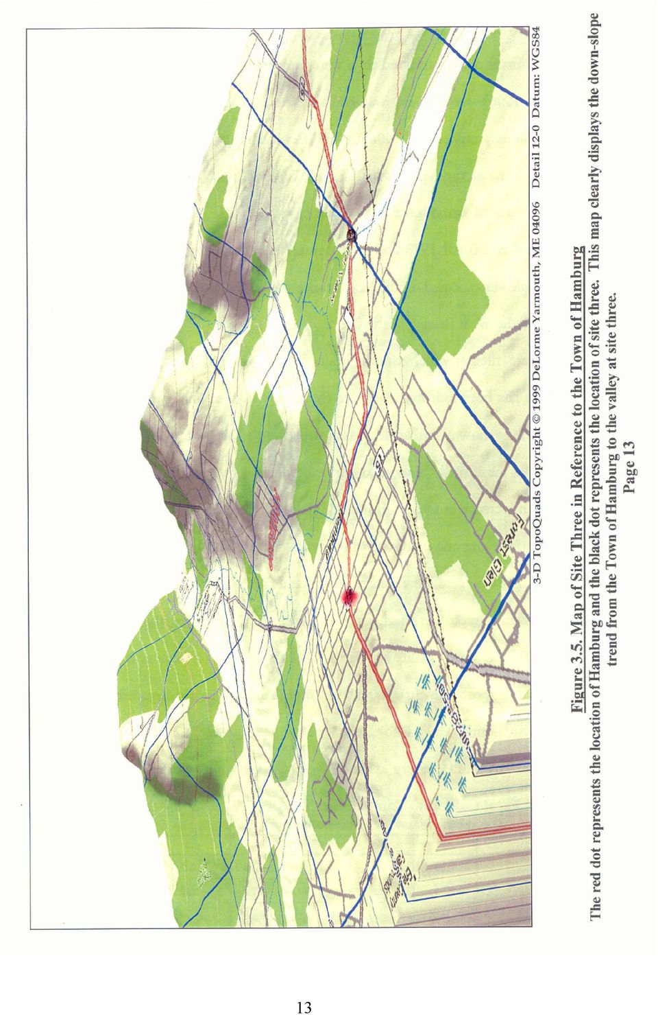
19 3.2.2 Fecal Coliforms Fecal coliforms are contributed to a waterway because of human, wildlife or livestock waste (Irvine, 1996). NYSDEC water quality standard for fecal coliforms states that no geometric mean may exceed 200/100mL (Gold Book, 2002). Fecal coliforms were measured as geometric means at various sites in 1973 and 2000 because that is what the water quality standards are based on (Figure 3.6). The graphs in Figure 3.6 summarize the fecal coliforms tested in 1973 and 2000 sampling. There were 5 sites at which sampling occurred in both 1973 and 2000 (Sites 1, 2, 3, 4 and 5). There has been a decrease of 7 and 69 percent at Sites one, two and four (Table 3.4). Sites two and four show a similar decreasing trend in the 2000 data as did the total coliform tested in 2000 at these sites. Site one on the other hand showed a decrease in fecal coliforms for 2000 but an increase in total coliforms. This could be caused by an increased addition of coliform bacteria at Site one that is not directly associated with feces or variation in the data. Site five has had a 271 percent increase since 1973 and the 2000 geometric mean was 56/100mL (Table 3.4). Even though there has been an increase in the levels, the 2000 data was sill below the NYS DEC water quality standards. Site three had a 65 percent increase since 1973 and the geometric mean was 301/100mL in 2000 (Table 3.4). This exceeds the NYS DEC standard of 200/100mL (Gold Book, 2002). This increase could be related to Site three s proximity to the Village of Hamburg as stated for total coliforms (Figure 3.5). Table 3.4. Fecal Coliform - Sample Data from each Year and Percent Change Geometric Mean for Fecal Coliforms (per 100mL) by Site Year % Change from 1973 to % -69% +65% -7% +271% 14
.")
20 Geometric Mean of Fecal Coliforms per site vs Fecal Coliforms per 100mL Year 2000 Year 1973 A) Sites East Branch Geometric Mean of Fecal Coliforms (Upstream to Downstream) vs Fecal Coliforms per 100mL Year 2000 Year 1973 B) Sites West Branch Geometric Mean of Fecal Coliforms (Upstream to Downstream) vs Fecal Coliforms per 100mL Year 2000 Year 1973 C) Sites Figure and 2000 Fecal Coliform Sample Site Values 15
 Sites West Branch Geometric Mean of Fecal 2000")
21 3.2.3 Biological Oxygen Demand (5-day) Biological Oxygen Demand (BOD 5 ) is useful for determining the extent of organic pollutants in a stream (ECDPH, 1970). BOD 5 represents the amount of oxygen that microbes require to break down organic matter (EEA, 2001). If the microbes are requiring a lot of oxygen the BOD 5 levels are higher indicating higher levels of organic matter are present including dead or decaying plant and animal life. There is no official water quality standard for BOD 5 but the indicator that is normally used states that a mean level of 2 mg/l and less indicates excellent water quality (EEA, 2001). Biological oxygen demand was measured as mean values at various sites in 2000, 1973 and 1970 because that is what the water quality standards were based on (Figure 3.7). The graphs in Figure 3.7 summarize the BOD 5 levels tested in 1970, 1973 and 2000 sampling. Table 3.5. Biochemical Oxygen Demand - Sample Data from each Year and Percent Change Mean for BOD (in milligrams per Liter) by Site Year % Change from 1970 to 2000 % Change from 1973 to % -78.5% -80.5% -65.5% -28% -66.7% -73.9% -68.8% -31.6% 16
22 All sites in 2000, except Site seven, can be compared to previous data from 1973 and/or 1970 (Table 3.5). The 1970 data shows Sites one, two and three were over the accepted limit of 2 mg/l, ranging from 3.1 to 4.2 mg/l. Sits six and seven from 1970 were below the accepted limit ranging from 1.4 to 1.7 mg/l. The 2000 data showed improvements because all sites had lower BOD values. Sample Sites two, three and four had the largest percent decrease ranging from 68.8 to 80.5 percent. All 2000 samples were below the accepted limit of 2 mg/l therefore indicating a general improvement in water quality when considering biological oxygen demand. Sample Sites one to four show a weak increasing trend as you move downstream. This would indicate that there is a slow increase in organic matter concentration as you move downstream. 17
23 Mean for BOD per site and 1973 vs BOD Year 2000 Year 1973 Year Sites East Branch - Mean for BOD (Upstream to Downstream) and 1973 vs BOD Year 2000 Year 1973 Year 1970 B) Sites West Branch - Mean for BOD (Upstream to Downstream) and 1973 vs C) BOD Sites Year 2000 Year 1973 Year 1970 Figure , 1973 and 2000 BOD Sample Site Values 18
24 3.2.4 Orthophosphates Orthophosphates, dissolved and inorganic, are a limiting factor that can affect the amount other nutrients can be consumed in a body of water (Sedgwick County, 2003). Excess orthophosphates can contribute to eutrophication of the water body (Sedgwick County, 2003). The Environmental Protection Agency (EPA) mean value recommendation limit for orthophosphates is 0.1 mg/l (EPA, 2003 (c)). Orthophosphates were measured as mean values a various sites in 1970, 1973 and 2000 because that is what the water quality standards were based on (Figure 3.8). The graphs in Figure 3.8 summarize the orthophosphate levels tested in 1970, 1973 and 2000 sampling. Table 3.6. Orthophosphates - Sample Data from each Year and Percent Change Mean for Orthophosphates (in milligrams per Liter) by Site Year % Change from 1970 to 2000 % Change from 1973 to % -90.9% -50.3% +7.1% % -69.6% % +25.0% +25.0% 19
25 Every site in the year 2000, except Site 7, can be compared to previous data from 1970 and/or 1973 sample data (Table 3.6). The 2000 sample Sites one, two and eight have had a decrease in levels of orthophosphates ranging from 69.6 to 100 percent change from the 1970 and 1973 data. Sample Sites four, five and six from the year 2000 had an increase in the percent change ranging from 7.1 to 100 percent. Sample Site three decreased by 75 percent from 1970 to 1973 but increased by 100 percent from 1973 to Even though there was an increase, the measured value of 0.06 mg/l was still below the EPA standard of 0.1 mg/l. Both the North and South Branches show a weak increasing trend as you move downstream indicating that the orthophosphate inputs are entering the stream and slightly increasing along the waterway. The weak increasing downstream trend indicates general improvement in the water quality of Eighteenmile Creek in regards to orthophosphates. Three sites in 1970 and one site in 1973 were above the recommended limit. This could be due to the fact that the Phosphorus Load Reduction Supplement to Annex 3 was not introduced until October of 1983 (EC, 1997). Levels would therefore decrease after this date as long as proper guidelines were followed that called for a decrease in phosphorus loads caused from detergents, fertilizer and manure. This idea is also supported by the Lake Erie total phosphorous downward trend from the 1960 s and 1970 s (EC, 1997). 20
26 Mean for Orthophosphates per site and 1973 vs Othophosphates Year 2000 Year 1973 Year Sites East Branch - Mean for Orthophosphates (Upstream to Downstream) and 1973 vs Othophosphates Year 2000 Year 1973 Year B) Sites West Branch - Mean for Orthophosphates (Upstream to Downstream) and 1973 vs Othophosphates Year 2000 Year 1973 Year C) Sites Figure , 1973 and 2000 Orthophosphates Sample Site Values 21
27 3.2.5 Chlorides Chlorides are found in all natural waters and results from mineral decomposition, agricultural and industrial wastes, sewage and contaminated groundwater that leaches into the stream (ECDPH, 1970) in addition to roadside runoff. Chloride is not harmful to humans except in high concentrations (ECDPH, 1970). The NYS DEC water quality standard for chlorides states that no maximum levels shall exceed 250 mg/l in a Class A stream (Gold Book, 2002). The reason that the standard for Class A stream was used is because the Eighteenmile Creek is a mix of Class A and Class B streams. Therefore using the Class A standard is the most restrictive. Chlorides were measured as maximum values at various sites in 1970 and 2000 because that is what water quality standards were based on (Figure 3.9). The graphs in Figure 3.9 summarize the chloride levels tested in 1970 and 2000 sampling. Table 3.7. Chlorides - Sample Data from each Year and Percent Change Maximum of Chlorides (in milligrams per Liter) by Site Year % Change from 1970 to % -76.7% +52.7% -53.1% -61.1% 22
28 The 1970 and 2000 sample data and percent change can be found in Table 3.7. Sites two, six and eight have had a decrease of 53.1 to 76.7 percent from Sites one and three have increased by 45.4 to 52.7 percent but all 2000 levels are still below the water quality standard of 250 mg/l. The 2000 values also indicate a weak increasing trend as you move downstream. This indicates that chlorides are being added to the waterway gradually, which is increasing the concentrations downstream. Only one site in 1970 exceeded the standard. The chloride level at Site two in 1970 was 300 mg/l. This could have been caused by a high flow event but the actual cause is unknown because the 1970 sample dates could not be found. This makes it impossible to compare the chloride values to the actual discharge data. 23
29 Maximum of Chlorides per site vs Chlorides Year 2000 Year Sites East Branch - Maximum of Chlorides (Upstream to Downstream) vs Chlorides Year 2000 Year 1970 B) Sites West Branch - Maximum of Chlorides (Upstream to Downstream) vs C) Chlorides Sites Year 2000 Year 1970 Figure and 2000 Chlorides Sample Site Values 24
30 3.2.6 Nitrates Nitrates can enter a water system by fertilizers, runoff, degradation of minerals and contaminated groundwater leaching (ECDPH, 1970). The NYS DEC water quality standard states that the maximum levels may not exceed 10 mg/l (Gold Book, 2002). Nitrates were measured as maximum values at various sites in 1970 and 2000 because that is what the water quality standards were based on (Figure 3.10). The graphs in Figure 3.10 summarize the nitrate levels tested in 1970 and 2000 sampling. Table 3.8. Nitrates - Sample Data from each Year and Percent Change Maximum of Nitrates (in milligrams per Liter) by Site Year % Change from 1970 to % -94.2% -95.1% % -86.4% 25
31 The 1970 data shows levels of nitrates that ranged from 5 to 28 mg/l (Table 3.8). The only site that was within the limits was Site eight in 1970 at 5 mg/l. The 2000 data showed a general reduction in nitrate levels. All sites in 2000 were within the standard and ranged from 0.21 to 1.62 mg/l. Therefore all sites decreased from 1970 to 2000 and the percent reduction ranged from 86.4 to percent. There are many possible reasons for the reduction of nitrates from the higher values in First there has been a general reduction of farmland in the area. As urban sprawl continues less land is being used for farming (Krapac et al., 2002). The second possibility could be better land management practices being used by the owners on the remaining nearby farmland (Krapac et al., 2002). Farming generally involves the fertilization of fields. The fertilizers can leach into groundwater and eventually into streams and other bodies of water (Krapac et al., 2002) or contaminate surface runoff. Fertilizing and spreading manure following soil test recommendations and adjusting timing and application methods in accordance with nutrient management plans are possible factors in reducing nitrate loading. Also, residential lawn care practices may also be improving with a trend away from heavy nitrogen fertilization of lawns (USDA NRCS, personal correspondence). 26
32 Maximum of Nitrates per site vs Nitrates Year 2000 Year Sites East Branch - Maximum of Nitrates (Upstream to Downstream) vs Nitrates Year 2000 Year 1970 B) Sites West Branch - Maximum of Nitrates (Upstream to Downstream) vs C) Nitrates Sites Year 2000 Year 1970 Figure and 2000 Nitrates Sample Site Values 27
33 4. CONCLUSIONS AND RECOMMENDATIONS The purpose of this research project was to: 1. Compare historical data to data retrieved from field samples collected in 2000 to determine if a change has occurred in the waterway and 2. Compare data from all sampling years to present day water quality standards. 1. The 2000 samples indicated that total coliform exceeded the NYS DEC water quality standards at Site one possibly due to a high flow or storm event. Other sites showed various increases and decreases from the historical data for total coliforms but they all are within the accepted limits of water quality standards. 2. The 2000 samples indicated that the fecal coliforms exceeded the NYS DEC water quality standards at Site three possibly due to the geographical location causing the site to receive runoff from the Village of Hamburg. All other sites were within the NYS DEC water quality standards for geometric mean fecal coliforms and the majority of the sites decreased compared to the historical data. 3. The 2000 samples indicated that the biological oxygen demand has had a general reduction compared to the 1970 and 1973 sample data. This indicates an improvement in water quality and a reduction of organic waste in the stream. 4. The 2000 samples indicate that orthophosphates have both increased and decreased at different sites compared to the 1970 and 1973 data. Although there has been variability all sites have improved through the years and all are below the EPA recommended limit of 0.1 mg/l. This indicates an improvement of water quality and a reduction of inorganic limiting factors in Eighteenmile Creek. 28
34 5. The 2000 samples indicate that chloride levels have both increased and decreased compared to 1970 and 1973 data. Although there have been various increases, all eight sites sampled in 2000 are still below the NYS DEC water quality standard of 250 mg/l. Most sites showed improvements in the water quality and very few had increases but none exceeded limits. 6. The 2000 samples indicate that nitrate levels have had a general reduction compared to 1970 sample data. This indicates an improvement in the water quality of the creek and a reduction in nitrate leaching. All eight sites from 2000 have improved compared to the 1970 and 1973 data and in general, the water quality standards were not exceeded for the 2000 sampling. Future analysis would be useful on the total coliform levels at Site one and the fecal coliform levels at Site three to help determine possible reasons for the higher numbers beyond what has already been explored in this study. Monitoring should also address water quality during storm events. Since there is evidence that contamination levels are higher with higher flows, inter-event sampling likely underestimates the severity of the water quality problems in the watershed. General monitoring should also be considered on a long-term basis to monitor any changes in water quality in the Eighteenmile Creek area. 29
35 5. REFERENCES Erie County Department of Public Health, 1970 Stream Survey on Eighteenmile Creek. Retrieved from Amy Holt from the Western New York Land Conservancy. (Pp. 1-5, 10-12, 24, 28-32, 37, 51-54) Erie County Department of Public Health, 1973 Stream Survey on Eighteenmile Creek. Retrieved from Amy Holt from the Western New York Land Conservancy. (Pp ) Erie County Department of Public Health, 1976 Stream Survey on Eighteenmile Creek. Retrieved from Amy Holt from the Western New York Land Conservancy. (Pp. 3-6, 47-58, 75-84) European Environment Agency (EEA) (2001). Biochemical Oxygen Demand in Rivers. Retrieved April 1 st, 2003 from: New York State Department of Environmental Conservation. Surface Water and Groundwater Quality Standards and Groundwater Effluent Limitations ( Gold Book ). Retrieved from: Irvine, K.N. (1996). Cazenovia Creek Watershed Management Program: Baseline Water Quality Analysis. Department of Geography and Planning, State University, Collage at Buffalo. Sedgwick County, KA Conservation District (2003). Nutrients are what is essential for life to exist and continue to develop. Retrieved April 1 st, 2003 from: United States Geological Survey Daily Stream Flow for Cazenovia Creek at Ebenezer, NY. (USGS reference number ) Retrieved on January 21 st, 2003 from: United States Geological Survey Daily Stream Flow for Cazenovia Creek at Ebenezer, NY. (USGS reference number ) Retrieved on January 21 st, 2003 from: United States Geological Survey Daily Stream Flow for Cazenovia Creek at Ebenezer, NY. (USGS reference number ) Retrieved on February 1 st, 2003 from: 30
36 APPENDIX A WATER QUALITY SAMPLE RESULTS PER SITE 31
37 Total Coliform (per 100 ml) Fecal coliform (per 100 ml) SITE ONE Raw Data By Date Ortho - phosphate Chlorides Nitrates Date BOD 6/19/ /27/ /2/ /10/ /18/ /25/ /1/ /8/ /15/ /21/ /28/ /5/ /13/ /4/ /8/ /13/ /3/ /7/ /5/ /2/ Data by Year Year Parameter Total Coliforms - Median Fecal Coliforms - Geometric Mean BOD - Mean Orthophosphates - Mean Chlorides - Maximum Nitrates - Maximum
38 SITE TWO Total Coliform (per 100 ml) Fecal coliform (per 100 ml) Raw Data By Date Ortho - phosphate Chlorides Nitrates Date BOD 6/19/ /27/ /13/ /4/ /8/ /13/ /3/ /7/ /5/ /2/ Data by Year Year Parameter Total Coliforms - Median Fecal Coliforms - Geometric Mean BOD - Mean 0.9 Orthophosphates - Mean Chlorides - Maximum Nitrates - Maximum
39 SITE THREE Total Coliform (per 100 ml) Raw Data By Date Fecal coliform (per 100 ml) BOD Dissolved Oxygen Ortho - phosphate Chlorides Nitrates Date 6/19/ /27/ /2/ /18/ /24/ /31/ /8/ /15/ /28/ /4/ /13/ /4/ /8/ /13/ /3/ /7/ /5/ /2/ Data by Year Year Parameter Total Coliforms - Median Fecal Coliforms - Geometric Mean BOD - Mean Orthophosphates - Mean Chlorides - Maximum Nitrates - Maximum
40 SITE FOUR Total Coliform (per 100 ml) Fecal coliform (per 100 ml) Raw Data By Date Ortho - phosphate Chlorides Nitrates Date BOD 6/27/ /2/ /18/ /24/ /31/ /8/ /15/ /4/ /13/ /4/ /8/ /13/ /3/ /7/ /5/ /2/ Data by Year Year Parameter Total Coliforms - Median Fecal Coliforms - Geometric Mean BOD - Mean Orthophosphates - Mean Chlorides - Maximum 65.9 Nitrates - Maximum
41 SITE FIVE Total Coliform (per 100 ml) Fecal coliform (per 100 ml) Raw Data By Date Ortho - phosphate Chlorides Nitrates Date BOD 6/19/ /27/ /2/ /10/ /18/ /31/ /8/ /15/ /4/ /13/ /4/ /8/ /13/ /3/ /7/ /5/ /2/ Data by Year Year Parameter Total Coliforms - Median Fecal Coliforms - Geometric Mean BOD - Mean Orthophosphates - Mean Chlorides - Maximum 47.8 Nitrates - Maximum
42 SITE SIX Total Coliform (per 100 ml) Fecal coliform (per 100 ml) Raw Data By Date Dissolved Oxygen Ortho - phosphate BOD Chlorides Nitrates Date 4/13/ /4/ /8/ /13/ /3/ /7/ /5/ /2/ Data by Year Year Parameter Total Coliforms - Median 345 Fecal Coliforms - Geometric Mean 53 BOD - Mean Orthophosphates - Mean Chlorides - Maximum Nitrates - Maximum
43 SITE SEVEN Total Coliform (per 100 ml) Fecal coliform (per 100 ml) Raw Data By Date Ortho - phosphate BOD Chlorides Nitrates Date 4/13/ /4/ /8/ /13/ /3/ /7/ /5/ /2/ Data by Year Year Parameter 2000 Total Coliforms - Median 520 Fecal Coliforms - Geometric Mean 138 BOD - Mean 0.8 Orthophosphates - Mean 0.02 Chlorides - Maximum 33.5 Nitrates - Maximum
44 SITE EIGHT Total Coliform (per 100 ml) Fecal coliform (per 100 ml) Raw Data By Date Ortho - phosphate BOD Chlorides Nitrates Date 4/13/ /4/ /8/ /13/ /3/ /7/ /5/ /2/ Data by Year Year Parameter Total Coliforms - Median 305 Fecal Coliforms - Geometric Mean 143 BOD - Mean Orthophosphates - Mean Chlorides - Maximum Nitrates - Maximum
Water Quality and Water Usage Surveys
 Appendix 1 Water Quality and Water Usage Surveys This appendix contains copies of the Water Quality Survey and the Lake Usage Survey that we used to complete the watershedbased community assessments. We
Mystic River Watershed Association Water Quality Monitoring: Malden River May 28 th 2002
 Mystic River Watershed Association Water Quality Monitoring: Malden River May 28 th 2002 Introduction The Mystic River Watershed Association, through its Mystic Monitoring Network (MMN) program, has been
Water Treatment Filtration Lab. discharged into an aquatic ecosystem? We had to build a water filtration system with
 Water Treatment Filtration Lab Brandon Lyons P.5 APES Abstract: How could polluted water be remediated so that it could support life when it is discharged into an aquatic ecosystem? We had to build a water
Parts per million (ppm) or Milligrams per liter (mg/l): one part by weight of analyte to 1 million parts by weight of the water sample.
 or Milligrams per liter (mg/l): one part by weight of analyte to 1 million parts by weight of the water sample.") 2015 Annual Drinking Water Quality Report St. Johns County Utility CR 214 Mainland We're pleased to present to you this year's Annual Water Quality Report. This report is designed to inform you about the
2015 Annual Drinking Water Quality Report St. Johns County Utility CR 214 Mainland We're pleased to present to you this year's Annual Water Quality Report. This report is designed to inform you about the
Water and Wastewater. Sample Collection and Analysis
 Water and Wastewater Sample Collection and Analysis December 2011 Introduction Accurate testing of drinking water is crucial to maintaining the health and safety of Islanders who rely on this resource.
How do you treat water based on water quality from different water sources?
 How do you treat water based on water quality from different water sources? Why? Authors: Wendy Lane and Kim Sciarrone Seattle Public Schools; Seattle, WA Water from different sources will contain different
2010 Annual Drinking Water Quality Report Collier County Water Department
 Annual Drinking Water Quality Report Collier County Water Department The Collier County Water Department is pleased to present this annual water quality report. We trust that you will read this report
PRECIPITATION AND EVAPORATION
 PRECIPITATION AND EVAPORATION OBJECTIVES Use historical data to analyze relationships between precipitation, evaporation and stream flow in the San Antonio River Basin TOPICS Water cycle Precipitation
WATER QUALITY MONITORING AND APPLICATION OF HYDROLOGICAL MODELING TOOLS AT A WASTEWATER IRRIGATION SITE IN NAM DINH, VIETNAM
 WATER QUALITY MONITORING AND APPLICATION OF HYDROLOGICAL MODELING TOOLS AT A WASTEWATER IRRIGATION SITE IN NAM DINH, VIETNAM LeifBasherg (1) OlujZejlllJul Jessen (1) INTRODUCTION The current paper is the
Public Water System. Consumer Confidence Report Template
 Public Water System Consumer Confidence Report Template Ohio Environmental Protection Agency Division of Drinking and Ground Waters www.epa.ohio.gov/ddagw Updated March 2015 Section 1: Title {Water System
DID YOU KNOW... THE IMPACT OF ON-SITE SEWAGE SYSTEMS AND ILLICIT DISCHARGES ON THE ROUGE RIVER
 DID YOU KNOW... THE IMPAT OF ON-SITE SEWAGE SYSTEMS AND ILLIIT DISHARGES ON THE ROUGE RIVER by Barry Johnson, P.E., M.S., amp Dresser & McKee and Dean Tuomari, Wayne ounty Department of Environment The
Phosphates (ortho- and total)
") INTRODUCTION Phosphates (ortho- and total) Phosphorus is an essential nutrient for all aquatic plants and algae. Only a very small amount is needed, however, so an excess of phosphorus can easily occur.
INTRODUCTION Phosphates (ortho- and total) Phosphorus is an essential nutrient for all aquatic plants and algae. Only a very small amount is needed, however, so an excess of phosphorus can easily occur.
AP ENVIRONMENTAL SCIENCE 2007 SCORING GUIDELINES
 AP ENVIRONMENTAL SCIENCE 2007 SCORING GUIDELINES Question 1 Read the Fremont Examiner article below and answer the questions that follow. (a) Identify ONE component of the sewage that is targeted for removal
TEXAS: SAN ANTONIO San Antonio Protects Edwards Aquifer
 TEXAS: SAN ANTONIO San Antonio Protects Edwards Aquifer Background San Antonio, the seventh largest city in the United States, covers approximately 515 square miles of Bexar County in south central Texas.
Welcome to the Understanding Dissolved Oxygen learning module. This section provides information on the following topics:
 Introduction Welcome to the learning module. This section provides information on the following topics: How dissolved oxygen is defined and measured in numbers Why dissolved oxygen is important Natural
5.14 Floodplains and Drainage/Hydrology
 I-70 East Final EIS 5.14 Floodplains and Drainage/Hydrology 5.14 Floodplains and Drainage/Hydrology This section discusses floodplain and drainage/hydrology resources and explains why they are important
STATUS REPORT: Bacteria and Other Contaminants in Domestic Water Wells in the Jackson Purchase Region
 ENRI-221 STATUS REPORT: Bacteria and Other Contaminants in Domestic Water Wells in the Jackson Purchase Region E. Glynn Beck, James Dinger, and Megan McMeans, Kentucky Geological Survey; William Thom,
Package Treatment Plant Policy and Procedure
 Package Treatment Plant Policy and Procedure PURPOSE There has been increased interest in the use of package treatment plants for new development proposals in the County. Current review procedures are
Total Suspended Solids Total Dissolved Solids Hardness
 Total Suspended Solids (TSS) are solids in water that can be trapped by a filter. TSS can include a wide variety of material, such as silt, decaying plant and animal matter, industrial wastes, and sewage.
Environmental Engineering, University of Seoul, Jennong-dong, Dongdaemun-gu, Seoul, Korea.
 WATER QUALITY MANAGEMENT FOR ECOLOGICAL RESTORATION IN ANYANG STREAM Yu, M.J., Cho, Y.M. 2, Lee, S.K. 3 Environmental Engineering, University of Seoul, Jennong-dong, Dongdaemun-gu, Seoul, Korea. 2 Department
Locating Point and Non-point Sources of Escherichia coli in the Mechumps Creek Watershed, Hanover County, Virginia
 Locating Point and Non-point Sources of Escherichia coli in the Mechumps Creek Watershed, Hanover County, Virginia Report Submitted to the Virginia Department of Environmental Quality Michael S. Fenster
Briefing Paper on Lower Galveston Bay and Bayou Watersheds Lower Bay I: Armand Bayou to Moses Lake and Adjacent Bay Waters
 Briefing Paper on Lower Galveston Bay and Bayou Watersheds Lower Bay I: Armand Bayou to Moses Lake and Adjacent Bay Waters Jim Lester, PhD. and Lisa Gonzalez Houston Advanced Research Center Galveston
CITY OF BAD AXE 2014 WATER QUALITY REPORT
 CITY OF BAD AXE 2014 WATER QUALITY REPORT In 1996, Congress amended the Safe Drinking Water Act which added a provision requiring that all community water systems provide their customers a brief annual
Comparing Levels of Phosphates in Dishwasher Detergents
 Lesson Plan Grades 9-12 Note: The Student Resource Page and Student Worksheets can be found at the end of this lesson plan. Essential Questions > How can phosphate levels in water be measured? > How much
How To Plan A Buffer Zone
 Backyard Buffers Protecting Habitat and Water Quality What is a buffer? A buffer (also called a riparian buffer area or zone) is the strip of natural vegetation along the bank of a stream, lake or other
Don t spit in the well - you may need to drink from it! -- Unknown, Russia.
 Don t spit in the well - you may need to drink from it! -- Unknown, Russia. WATER POLLUTION Water is a unique substance, because it can naturally renew and cleanse itself, by allowing pollutants to settle
Freshwater Resources and Water Pollution
 Visualizing Environmental Science Freshwater Resources and Water Pollution Chapter 10 Copyright The Importance of Water Life on Earth would be impossible without water All living organisms contain water
LIMNOLOGY, WATER QUALITY
 LIMNOLOGY, WATER QUALITY PA RANI ET E R S, AN D c 0 IV D IT I 0 N S AND ECOREGIONS Water Quality Parameters Nutrients are important parameters because phosphorous and nitrogen are major nutrients required
Maine Department of Environmental Protection Program Guidance On Combined Sewer Overflow Facility Plans
 Maine Department of Environmental Protection Program Guidance On Combined Sewer Overflow Facility Plans OVERVIEW The objective of a Combined Sewer Overflow (CSO) Facility Plan is to abate CSO discharges
Ginger Paige and Nancy Mesner University of Wyoming Utah State University
 Effective Water Quality BMP Monitoring Tools Ginger Paige and Nancy Mesner University of Wyoming Utah State University Overview BMP Monitoring Guidance Document for Stream Systems Lessons learned CEAP
Phosphorus. Phosphorus Lake Whatcom Cooperative Management. www.ecy.wa.gov/programs/wq/nonpoint/phosphorus/phosphorusban.html
 Phosphorus Phosphorus Brochure Lake Whatcom Cooperative Management Reducing Phosphorus Website Washington State Department of Ecology www.ecy.wa.gov/programs/wq/nonpoint/phosphorus/phosphorusban.html Nutrients
Chapter 14 Quiz. Multiple Choice Identify the choice that best completes the statement or answers the question.
 Chapter 14 Quiz Multiple Choice Identify the choice that best completes the statement or answers the question. 1. Which of the following is NOT true regarding the Chesapeake Bay? a. it is one of many small
City of Charlottetown Wastewater Treatment Expansion & Upgrading
 City of Charlottetown Wastewater Treatment Expansion & Upgrading Background As Canada s smallest provincial capital, the City of the Charlottetown has a population of approximately 34,000 residents and
Part B Integrated Monitoring Design for Comprehensive Assessment and Identification of Impaired Waters Contents
 Part B Integrated Monitoring Design for Comprehensive Assessment and Identification of Impaired Waters Contents Chapter 10. Selecting Metrics or Indicators of WQS Attainment... 10-2 Chapter 11. Monitoring
Report prepared by: Kelly Hagan and Mark Anderson Grand River Conservation Authority 400 Clyde Road Cambridge ON N1R 5W6
 2013 Watershed Overview of Wastewater Treatment Plant Performance Report prepared by: Kelly Hagan and Mark Anderson Grand River Conservation Authority 400 Clyde Road Cambridge ON N1R 5W6 Table of Contents
Observatory monitoring framework indicator data sheet
 Observatory monitoring framework indicator data sheet Environmental impact: Water Indicator DA3: Nitrate and phosphate levels in rivers The EU Water Framework Directive has resulted in the need to change
WASTEWATER TREATMENT OBJECTIVES
 WASTEWATER TREATMENT OBJECTIVES The student will do the following: 1. Define wastewater and list components of wastewater. 2. Describe the function of a wastewater treatment plant. 3. Create a wastewater
Swamp Area Passive Treatment System Kettle Creek Watershed, Clinton County, PA
 Swamp AMD Chemistry Swamp Area Passive Treatment System Kettle Creek Watershed, Clinton County, PA A Technical Report for Trout Unlimited and the Kettle Creek Watershed Association Prepared by Hedin Environmental
How To Know If Your Well Water Is Safe
 Bernalillo County Office of Environmental Health A comprehensive guide to help maintain your well and keep your drinking water safe Bernalillo County Office of Environmental Health Bernalillo County Commission
4. Environmental Impacts Assessment and Remediation Targets
 4. Environmental Impacts Assessment and Remediation Targets 4.1 Environmental Impacts Significant additional development in the Alder Creek watershed is not anticipated at this time; however, there are
The Nitrate Contamination of Private Well Water in Rural Northwest Kansas
 Cantaurus, Vol. 9,12-17, May 2001 McPherson College Division of Science and Technology The Nitrate Contamination of Private Well Water in Rural Northwest Kansas Ryan Hargitt ABSTRACT Twenty percent of
Presented by Paul Krauth Utah DEQ. Salt Lake Countywide Watershed Symposium October 28-29, 2008
 Basic Nutrient Removal from Water Beta Edition Presented by Paul Krauth Utah DEQ Salt Lake Countywide Watershed Symposium October 28-29, 2008 Presentation Outline Salt Lake County waters / 303(d) listings
NAPA COUNTY WATERSHED SYMPOSIUM
 Planning, Building, and Environmental Services NAPA VALLEY GROWTH NAPA COUNTY WATERSHED SYMPOSIUM Plunging Forward May 15, 2015 1 YOU CAN T CROSS THE SEA MERELY BY STANDING AND STARING AT THE WATER. Rabindranath
Nutrient Stewardship. Reducing the Loss of Crop Nutrients to Waterways
 ETS & PERFORMANCE FOOD ENVIRONMENT PEOPLE COMPANY Nutrient Stewardship Reducing the Loss of Crop Nutrients to Waterways Crop nutrients help plants grow and produce the food, fiber and fuel we all need.
COMPREHENSIVE PLAN SECTION B, ELEMENT 4 WATER RESOURCES. April 20, 2010 EXHIBIT 1
 COMPREHENSIVE PLAN SECTION B, ELEMENT 4 WATER RESOURCES April 20, 2010 EXHIBIT 1 ELEMENT 4 WATER RESOURCES TABLE OF CONTENTS 4.1 INTRODUCTION 4.2 GOALS AND POLICIES 4.2.A General Goals and Policies 1 4.2.B
Homeowner s GUIDE. to living with a well and septic system. Northeast Colorado. Health. Department. Replacement System. Leach Field. Septic Tank.
 Homeowner s GUIDE to living with a well and septic system Northeast Colorado Health Department Replacement System Leach Field Septic Tank Well Congratulations on the purchase of your new home. Living in
MEMO: Discussion of Potential Groundwater Nitrogen Impacts and Mitigation Costs in Areas Surrounding the Kreider Farms Operations
 MEMO: Discussion of Potential Groundwater Nitrogen Impacts and Mitigation Costs in Areas Surrounding the Kreider Farms Operations From: Dr. Barry M. Evans, Penn State University Date: May 25, 2012 Introduction
FACTS. Nitrate and Nitrite in Drinking Water. What Are Nitrate and Nitrite? 3. How Can These Chemicals Get into Your Drinking Water?
 FACTS Nitrate and Nitrite in Drinking Water What Are Nitrate and Nitrite? 3 How Can These Chemicals Get into Your Drinking Water? 3 How Can You Find Out If These Chemicals Are in Your Drinking Water? 4
Understanding Complex Models using Visualization: San Bernardino Valley Ground-water Basin, Southern California
 Understanding Complex Models using Visualization: San Bernardino Valley Ground-water Basin, Southern California Zhen Li and Wesley R. Danskin U.S. Geological Survey, zhenli@usgs.gov, wdanskin@usgs.gov,
STORMWATER MONITORING: POLLUTANTS, SOURCES, AND SOLUTIONS
 RICHLAND COUNTY STORMWATER MANAGEMENT DIVISION STORMWATER MONITORING: POLLUTANTS, SOURCES, AND SOLUTIONS As part of the federal government s National Pollutant Discharge Elimination System Permit (NPDES)
Total Suspended Solids: The Hows & Whys of Controlling Runoff Pollution
 New State Storm Water Rules: WHAT MUNICIPALITIES NEED TO KNOW Total Suspended Solids: The Hows & Whys of Controlling Runoff Pollution Stormwater management by Wisconsin municipalities is under scrutiny.
TENNESSEE GAS PIPELINE COMPANY, L.L.C.
 TENNESSEE GAS PIPELINE COMPANY, L.L.C. HYDROLOGIC & HYDRAULIC CALCULATIONS FOR WATERBODIES CROSSED BY CONNECTICUT PIPELINE EXPANSION PROJECT CONNECTICUT LOOP Submitted by: Tennessee Gas Pipeline Company,
WASTEWATER TREATMENT
 Freshwater WASTEWATER TREATMENT Water Quality 1. INDICATOR (a) Name: Wastewater treatment. (b) Brief Definition: Proportion of wastewater that is treated, in order to reduce pollutants before being discharged
septic systems What is a Septic System? How does a Septic System Work?
 septic systems What is a Septic System? A septic system is a private sewage treatment system. They are common in rural areas where there are no municipal sewage pipes for homes, farms, businesses or other
Street Address (number and street): City: County: ZIP Code: B. CURRENT SITE PRIORITY INFORMATION Was free product present this quarter?
: City: County: ZIP Code: B. CURRENT SITE PRIORITY INFORMATION Was free product present this quarter?") QUARTERLY MONITORING REPORT (QMR) COVER SHEET AND REPORT FORMAT State Form 56087 (6-16) 329 IAC 9-5 Indiana Department of Environmental Management Office of Land Quality Leaking Underground Storage Tank
QUARTERLY MONITORING REPORT (QMR) COVER SHEET AND REPORT FORMAT State Form 56087 (6-16) 329 IAC 9-5 Indiana Department of Environmental Management Office of Land Quality Leaking Underground Storage Tank
TARP Section 2.2 Stormwater BMP Screening for Validation
 Requirements for Final Certification of Manufactured Treatment Devices for Total Suspended Solids Removal Based on Field Testing Amendments to TARP Protocol DRAFT April 28, 2009 The New Jersey Stormwater
NPDES Permit No. IL0052639. Notice No. IL0052639-12.TTL. Public Notice Beginning Date: June 15, 2012. Public Notice Ending Date: July 16, 2012
 NPDES Permit No. IL0052639 Notice No. IL0052639-12.TTL Public Notice/Fact Sheet Issued By: Public Notice Beginning Date: June 15, 2012 Public Notice Ending Date: July 16, 2012 National Pollutant Discharge
City of East Lansing CSO Control Facility Evaluation Demonstrative Approach to Meet WQS
 City of East Lansing CSO Control Facility Evaluation Demonstrative Approach to Meet WQS Jeff Johnston, East Lansing WWTP Superintendent & Tom Maxwell, P.E., Hubbell, Roth & Clark, Inc. East Lansing CSO
Overview of Best Available Technologies for Onsite Septic Systems and Management Considerations Presentation to NAHB
 Overview of Best Available Technologies for Onsite Septic Systems and Management Considerations Presentation to NAHB A. R. Rubin, Professor Emeritus, NCSU-BAE Technical Wastewater Issues Treatment Septic
2014 Report. water Quality. Cleveland Water
 2014 Report water Quality Cleveland Water Commitment to Quality Cleveland Water is committed to providing all of our customers with a virtually unlimited supply of clean, safe, potable water. This commitment
Useful Septic System Statistics
 GENERAL Useful Septic System Statistics - About 25% of the nation s households are served by onsite/septic systems (see Census data) - Approximately 33% of new construction is served by onsite systems
Michigan Wetlands. Department of Environmental Quality
 Department of Environmental Quality Wetlands are a significant component of Michigan s landscape, covering roughly 5.5 million acres, or 15 percent of the land area of the state. This represents about
NOTICE OF PREPARATION
 PLANNING DIVISION CITY OF SUNNYVALE P.O. BOX 3707 SUNNYVALE, CA 94088-3707 NOTICE OF PREPARATION TO: Responsible, Trustee, and Other Interested Public Agencies FROM: Sunnyvale Community Development 456
Handbook for Developing Watershed Plans to Restore and Protect Our Waters
 This document is one chapter from the EPA Handbook for Developing Watershed Plans to Restore and Protect Our Waters, published in March 2008. The reference number is EPA 841-B-08-002. You can find the
As stewards of the land, farmers must protect the quality of our environment and conserve the natural resources that sustain it by implementing
 N A T U R A L R E S O U R C E C O N S E R V A T I O N As stewards of the land, farmers must protect the quality of our environment and conserve the natural resources that sustain it by implementing conservation
Cambridge Wastewater Treatment Facility
 Cambridge Wastewater Treatment Facility Emergency Situations If you have a water or sewer emergency that relates to the City s utility system call the Public Works office at 763-689-1800 on normal working
AERIAL PHOTOGRAPHS. For a map of this information, in paper or digital format, contact the Tompkins County Planning Department.
 AERIAL PHOTOGRAPHS What are Aerial Photographs? Aerial photographs are images of the land taken from an airplane and printed on 9 x9 photographic paper. Why are Aerial Photographs Important? Aerial photographs
MASSACHUSETTS COASTAL NONPOINT PROGRAM NOAA/EPA DECISIONS ON CONDITIONS OF APPROVAL
 MASSACHUSETTS COASTAL NONPOINT PROGRAM NOAA/EPA DECISIONS ON CONDITIONS OF APPROVAL FOREWORD This document contains the basis for NOAA and EPA s decision to fully approve Massachusetts Coastal Nonpoint
CHAPTER 2 HYDRAULICS OF SEWERS
 CHAPTER 2 HYDRAULICS OF SEWERS SANITARY SEWERS The hydraulic design procedure for sewers requires: 1. Determination of Sewer System Type 2. Determination of Design Flow 3. Selection of Pipe Size 4. Determination
SOIL TEST LEVELS AND NUTRIENT BUDGETS IN THE WESTERN U.S.
 SOIL TEST LEVELS AND NUTRIENT BUDGETS IN THE WESTERN U.S. Robert L. Mikkelsen and Paul E. Fixen Potash & Phosphate Institute ABSTRACT The status of potassium (K) and phosphorus (P) nutrient concentrations
Appendix D lists the Field Services Standard Operating Procedures. Appendix E lists the Biological Monitoring Standard Operating Procedures.
 Page 16 of 87 3.3 Sample Collection, Storage and Preservation Figure 3 details required containers, sample volumes, preservation techniques, and holding times for proper sample collection. A discussion
Nutrient Management Plan Implementation Workshop
 Nutrient Management Plan Implementation Workshop Sam Sampath CAFO Permitting Coordinator, WPD, EPA, Region 4 October 19-20, 2010 Hilton Garden Inn, Atlanta 1 Highlights of 2008 CAFO Final Rule Revises
STATE OF CALIFORNIA CALIFORNIA REGIONAL WATER QUALITY CONTROL BOARD LOS ANGELES REGION
 STATE OF CALIFORNIA CALIFORNIA REGIONAL WATER QUALITY CONTROL BOARD LOS ANGELES REGION ORDER NO. R4-2003-0142 WASTE DISCHARGE REQUIREMENTS FOR WESTERN LOS ANGELES COUNTY COUNCIL, INC. BOY SCOUTS OF AMERICA
BY-LAW CONCERNING DISCHARGES AT PURIFICATION WORKS ON THE TERRITORY OF THE URBAN AGGLOMERATION OF MONTRÉAL
 VILLE DE MONTRÉAL BY-LAW RCG 08-041 BY-LAW CONCERNING DISCHARGES AT PURIFICATION WORKS ON THE TERRITORY OF THE URBAN AGGLOMERATION OF MONTRÉAL In view of article 17 of the by-law entitled Règlement sur
ESSENTIAL COMPONENTS OF WATER-LEVEL MONITORING PROGRAMS. Selection of Observation Wells
 ESSENTIAL COMPONENTS OF WATER-LEVEL MONITORING PROGRAMS Before discussing the uses and importance of long-term water-level data, it is useful to review essential components of a water-level monitoring
Rocky EEP Preliminary Findings Report Summary February 2005
 This is a DRAFT summary of the NC Ecosystem Enhancement Upper Rocky River Local Watershed Plan Preliminary Findings Report. The original, 157 page document can be found here: www.ncsu.edu/weco/rocky. The
Position Description for Conservation Specialist
 Position Description for Conservation Specialist Position Summary This Conservation Specialist position is focused primarily on helping to conserve natural resources associated with small farms. Wildlife
Curt Kerns, M.S., R.P.Bio., C.F.S. WetlandsPacific Corp. 250-722-7117 www.wetlandspacific.com
 Curt Kerns, M.S., R.P.Bio., C.F.S. WetlandsPacific Corp. 250-722-7117 www.wetlandspacific.com Presentation Historical perspectives Present perspectives How wetlands function Examples of natural wetlands
NAJAFGARH DRAIN-SAMPLING AND ANALYSIS
 Dr. Anamika Paul* Preeti Jain* Kartikey Handa* NAJAFGARH DRAIN-SAMPLING AND ANALYSIS Abstract: Over the past years, due to rapid industrialization and advanced agricultural activities environmental deterioration
Chehalis River Basin Flood Damage Reduction 2013-2015 Capital Budget Approved by Legislature in June 2013
 Chehalis River Basin Flood Damage Reduction 2013-2015 Capital Budget Approved by Legislature in June 2013 1. Design alternatives for large capital flood projects (basinlevel water retention and Interstate
Development of an Impervious-Surface Database for the Little Blackwater River Watershed, Dorchester County, Maryland
 Development of an Impervious-Surface Database for the Little Blackwater River Watershed, Dorchester County, Maryland By Lesley E. Milheim, John W. Jones, and Roger A. Barlow Open-File Report 2007 1308
Who is responsible for making sure that wastewater is treated properly?
 WASTEWATER TREATMENT What is wastewater? Wastewater is water that has been used and must be treated before it is released into another body of water, so that it does not cause further pollution of water
Section 5: Conserve to Enhance Program Goals What is Conserve to Enhance All About?
 Section 5: Conserve to Enhance Program Goals What is Conserve to Enhance All About? Conserve to Enhance (C2E) was originally conceptualized as an approach to giving the environment a seat at the table
Toxic Municipal Waste Water Treatment
 FINAL IC/24 February 2000 Recommendation concerning the Treatment of Municipal Waste Water 2 Recommendation concerning the Treatment of Municipal Waste Water The Commission, recalling Paragraph 1 of Article
Algal Blooms, Circulators, Waterfowl and Eutrophic Greenfield Lake, NC. Michael A. Mallin, Matthew R. McIver, Ellen J. Wambach, and Anna R.
 Algal Blooms, Circulators, Waterfowl and Eutrophic Greenfield Lake, NC Michael A. Mallin, Matthew R. McIver, Ellen J. Wambach, and Anna R. Robuck Center for Marine Science University of North Carolina
Watershed Education for Teachers. Cinde Thomas-Jimenez Guadalupe-Blanco River Authority
 Watershed Education for Teachers Cinde Thomas-Jimenez Guadalupe-Blanco River Authority In This Presentation Why Watersheds Matter What Is a Watershed Water Quality Parameters Point Source and NonPoint
Travel Centers of America 1003300
 Travel Centers of America 1003300 Source Water Assessment Report A State Assessment of Your Drinking Water Source s Vulnerability As a requirement of the 1996 Amendments to the Federal Safe Drinking Water
Quantification of Reactive Phosphorus in Lake Mendota Sediments
 Quantification of Reactive Phosphorus in Lake Mendota Sediments By: Jeremy, Advisor Dr. Mike Penn Most of the phosphorus (P) that enters lakes from external inputs is attached to soil or sediment. This
Water Quality Management
 Water Quality Management Sustainable agriculture practices detailed in other sections of this publication are important ways to maintain or improve water quality on the farm and downstream from the farm.
Nitrate Levels in Wells
 Nitrate Levels in Wells VIRGINIA SOL Science ES.7, ES.9 Social studies WG.1, WG.7, WG.12, GOVT.1 Language arts 9.6, 9.8 Technology C/T12.2, C/T12.3, C/T12.4 OBJECTIVES Discuss dangers of high nitrate levels
Importante: Si usted tiene alguna pregunta sobre este informe favor de llamar a Lee County Utilities al 239-533-8181.
 Lee County Utilities 2015 Water Quality Report Importante: Si usted tiene alguna pregunta sobre este informe favor de llamar a Lee County Utilities al 239-533-8181. Introduction Lee County Utilities (LCU)
Sewerage Management System for Reduction of River Pollution
 Sewerage Management System for Reduction of River Pollution Peter Hartwig Germany Content page: 1 Introduction 1 2 Total emissions 3 3 Discharge from the wastewater treatment plants 4 4 Discharge from
water quality 2007 annual report Huntington District Our Customer Charter Dear West Virginia American Water Customer,
 Dear West Virginia American Water Customer, 2007 annual water quality report You are our top priority. And delivering reliable, high-quality water to you all day, every day is our mission. We deliver at
Pamela Birak, Jordan Lake State Park, Chatham County, NC
 Pamela Birak, Jordan Lake State Park, Chatham County, NC 3 Lakes, Reservoirs, and Ponds Forty-six states, Puerto Rico, and the District of Columbia (collectively referred to as states in the rest of this
Analysis of Total Suspended Solids and Dissolved Oxygen Concentrations of the Algal- Bacterial Selenium Removal (ABSR) system.
 system.") Analysis of Total Suspended Solids and Dissolved Oxygen Concentrations of the Algal- Bacterial Selenium Removal (ABSR) system Veasna Hang Abstract The Algal-Bacterial Selenium Removal (ABSR) system has
Analysis of Total Suspended Solids and Dissolved Oxygen Concentrations of the Algal- Bacterial Selenium Removal (ABSR) system Veasna Hang Abstract The Algal-Bacterial Selenium Removal (ABSR) system has
1997-98 UPPER DESCHUTES R-EMAP TEMPERATURE SUMMARY
 1997-98 UPPER DESCHUTES R-EMAP TEMPERATURE SUMMARY Daria G. Mochan Oregon Department of Environmental Quality Laboratory Division Biomonitoring Section 1712 S.W. Eleventh Avenue Portland, Oregon 97201
NPDES Permit No. IL0020737. Notice No. SKT:13120601.bah. Public Notice Beginning Date: April 9, 2014. Public Notice Ending Date: May 9, 2014
 Public Notice/Fact Sheet Issued By: Notice No. SKT:13120601.bah Public Notice Beginning Date: April 9, 2014 Public Notice Ending Date: May 9, 2014 National Pollutant Discharge Elimination System (NPDES)
4 Water supply description
 4 Water supply description A description of the drinking-water system is equally applicable to large utilities with piped distribution systems, piped and non-piped community supplies, including handpumps
LR 314 Working Group 5 Final Report
 LR 314 Working Group 5 Final Report I. Nebraska Department of Natural Resources Table 1. NDNR and NATURAL RESOURCES COMMISSION WATER/INTEGRATED MANAGEMENT PLANNING RELATED RESEARCH, STUDIES AND RELATED