This paper has been mechanically scanned. Some errors may have been inadvertently introduced.
|
|
|
- Allison Lyons
- 8 years ago
- Views:
Transcription
1 This paper has been mechanically scanned. Some errors may have been inadvertently introduced.

2 CALIFORNIA PATH PROGRAM INSMTUTE OF TRANSPORTATION STUDIES UNIVERSITY OF CALIFORNIA, BERKELEY Smart Corridor Evaluation Plan: Conceptual Design Mark Miller Asad Khattak Randolph Hall Genevieve Giuliano James Moore Martin Wachs California PATH Research Paper UCB-ITS-PRR This work was performed as part of the California PATH Program of the University of California, in cooperation with the State of California Business, Transportation, and Housing Agency, Department of Transportation; and the United States Department Transportation, Federal Highway Administration. The contents of this report reflect the views of the authors who are responsible for the facts and the accuracy of the data presented herein. The contents do not necessarily reflect the official views or policies of the State of California. This report does not constitute a standard, specification, or regulation. February 1994 ISSN

3 SMART CORRIDOR EVALUATION PLAN: CONCEPTUAL DESIGN FINAL REPORT prepared for the Santa Monica Freeway Smart Corridor Technical CommitteeKaltrans prepared by the Smart Corridor Evaluation Plan Design Team: Mark Miller Asad Khattak Randolph Hall of Partners for Advanced Transit and Highways (PATH) Institute of Transportation Studies University of California, Berkeley Genevieve Giuliano James Moore of the School of Urban & Regional Planning Department of Civil Engineering University of Southern California Martin Wachs of the Graduate School of Architecture & Urban Planning University of California, Los Angeles January 1994

4 TABLE OF CONTENTS List of Tables List of Figures Page iv SECTION INTRODUCTION 1.1 Study Objectives Organization of the Report Overview of the Smart Corridor Demonstration Project Smart Corridor Studies Studies on Other IVHS Evaluation Projects 5 2. CONCEPTUAL STRUCTURE OF THE EVALUATION PLAN Study Goals and Objectives 2.2 Research Design Framework 2.3 Research Framework for Project Components Roadway Network Performance Traveler Response Role of Information in Traveler Decision Making Institutional Evaluation Emissions and Energy Impacts Assessment Smart Corridor Operational Performance DATA REQUIREMENTS AND COLLECTION METHODS Surveillance System Traffic Volume and Occupancy Detector Data Signal Control Data Data Samples Traveler Surveys Survey Timing 30

5 TABLE OF CONTENTS (continued) Section Target Population Questionnaire Format Agency Records Emission and Energy Impacts Assessment Non-recurring Incidents Institutional Issues Smart Corridor System Logs Smart Corridor Operational Performance Non-recurring Incidents METHODS FOR DATA REDUCTION AND ANALYSIS Roadway Network Performance Traveler Response Emissions and Energy Impacts Assessment Smart Corridor Operational Performance Institutional Issues 43 REFERENCES 46 Appendix A Potential for Diversion to Arterial Streets 48 B Determination of Sample Size 52 C Sample Questions for Broad Survey 54 D Sample Questionnaire for Panel Survey (Short Mail Out Version) 56

6 LIST OF TABLES 1 Goals and Objectives 7 2 Regression Model Estimation Results for Volume to Capacity (V/C) Ratios in the Smart Corridor
 Ratios in the Smart")
7 LIST OF FIGURES PalEe Smart Corridor Region Flow of Research Information Traffic Diversion During an Incident Drawing Region Corridor Volumes During an Incident: With and Without Diversion Traffic Volume Distribution During an Incident Real-world Dynamics of Traveler Behavior Traveler Decision Making Process Influence of Various Technologies on Traveler s Decisions Design of Traveler Behavior Surveys Three-way Layout for Analysis of Variance (ANOVA) iv
 3 9 10 11 13 14 19 20 21 29")
8 1. INTRODUCTION This document is the final report for PATH MOU 98, Design of Evaluation Plan for Smart Corridor, performed by California PATH under contract to Caltrans. This report presents the Conceptual Design Plan for evaluating the effectiveness of the Smart Corridor Demonstration Project. Follow-up work is required to produce a completely specified and implementable evaluation plan and should focus on methods for data collection, reduction, and analysis, the schedule, budget, and deliverables. The evaluation project is one of approximately thirty components of the entire Smart Corridor Demonstration Project. The Smart Corridor Demonstration Project is funded by several governmental agencies, including the Federal Highway Administration (FHWA), Caltrans, California Highway Patrol (CHP), Los Angeles County Metropolitan Transportation Authority (LACMTA), Los Angeles Department of Transportation (LADOT), Culver City, Beverly Hills, and the Los Angeles Police Department (LAPD). Overall, the Smart Corridor is designed to obtain improved utilization of existing roadway facilities, both freeway and arterial, through the use of Advanced Traveler Information Systems (ATIS) and Advanced Traffic Management Systems (ATMS), through improved inter-agency coordination, and through better use of conventional traffic management strategies. 1.1 STUDY OBJECTIVES The purpose of this study is to develop a plan for the comprehensive evaluation of the Smart Corridor Demonstration Project. To assist in the fulfillment of this objective, several documents were reviewed, including a draft evaluation design plan produced as part of previous Smart Corridor-related work by JHK & Associates [ 11, and evaluation design plans for such related demonstration projects in the United States as Pathfinder (Farradyne Systems, Inc. and JHK & Associates [2]), TravTek (Farradyne Systems, Inc. and The Center for Applied Research [3]), INFORM (Peat, Marwick, Mitchell & Co. and JHK & Associates [4]), and FAME (Washington State Department of Transportation [5]). The specific objectives of this report are to develop a conceptual structure for the Smart Corridor evaluation, define evaluation data requirements and collection procedures, and select and/or develop data reduction and data analysis methodologies. The evaluation project should be comprehensive and should include studies of network performance, traveler response, institutional effectiveness, system operational performance, and environmental impacts.

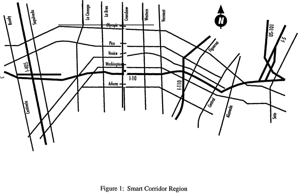
9 1.2 ORGANIZATION OF THE REPORT This report consists of four major sections, this introduction being Section 1. Section 2 describes the overall conceptual framework for conducting the evaluation. Section 3 identifies general data requirements and collection methods to be used to develop a complete evaluation data base. The primary data sources to be used for the evaluation, consisting of surveillance systems, traveler surveys, agency records, and interviews are discussed, Section 4 outlines procedures for reducing and analyzing the data, and describes statistical significance tests applicable to the evaluation. 1.3 OVERVIEW OF THE SMART CORRIDOR DEMONSTRATION PROJECT The Smart Corridor Demonstration Project is a multi-agency undertaking utilizing the combined weight of Advanced Traveler Information Systems and Advanced Traffic Management Systems, in addition to existing methods and services, to address all forms of traffic congestion on the Santa Monica freeway corridor. Geographically, the study area is approximately five miles wide and fourteen miles long, encompassing the region between Centinela Avenue on the west, Soto Street on the east, Olympic Boulevard on the north, and Adams and Washington Boulevards on the south (Figure 1). The principal roadway segment of the Smart Corridor is Interstate 10 (Santa Monica Freeway). Major parallel arterial roadways in the corridor are Olympic, Pica, Venice, Washington, and Adams Boulevards. The roadway configuration of the corridor is integral to its choice as the site for this demonstration project. The five major arterials parallel to and within a few miles of a major east-west freeway corridor (Interstate 10) offer an opportunity to alleviate the interlinked issues of traffic congestion, safety, and air quality. The project s purpose is to address not only problems of mobility within the corridor, but also those of on-road mobile source emissions and energy usage. These issues wil.l be addressed technologically through traveler information devices, signal control and incident response. The Smart Corridor system will strive to address these problems by 1) continuous monitoring and controlling traffic flows, especially during conditions of recurring and nonrecurring congestion, 2) managing accidents and other roadway incidents, 3) providing information to motorists, and 4) controlling traffic signals to dynamically improve traffic flow. Monitoring and control of traffic flows will be accomplished through the expanded use of existing systems for both freeway and arterial traffic, under the coordinated management of the Smart Corridor centralized computer system. Caltrans currently monitors freeways via its Semi-Automated Traffic Management System (SATMS), which also controls freeway access with ramp metering. The Los Angeles Department of Transportation currently monitors and controls arterial traffic in several areas throughout the city, including the Los Angeles Central Business District (CBD), the Sports Arena/Coliseum area, Los Angeles International Airport, Westwood, and on Ventura 2

10 I I \ I 4 I I I I I
11 Boulevard in the San Fernando Valley between Lankershim and Mulholland Boulevards. This activity is carried out through the use of computerized arterial signal control, the Automated Traffic Surveillance and Control (ATSAC) system. The monitoring of non-recurring incidents, such as accidents and vehicle breakdowns, will continue through the expanded use of Closed Circuit Television (CCTV) on the freeway and arterials, freeway call boxes, cellular phones, and Freeway Service Patrols (FSP). Motorist information will be provided through the expanded use of existing services and the introduction of new ones. Examples of these services are Changeable Message Signs (CMS) on freeways and arterials, Trailblazer (detour) signs on arterials, Highway Advisory Radio (HAR), and Highway Advisory Telephone (HAT). Most of the Smart Corridor s elements are being deployed in a phased implementation process over the course of approximately a year and a half. In addition to these technological means of addressing the corridor s mobility problems, the project will strive to implement a heretofore unprecedented level of inter-agency cooperation and coordination. The blending of both the technological and institutional aspects will determine the level of success for the Smart Corridor Demonstration Project Smart Corridor Studies Prior studies related to the Smart Corridor have used survey research, simulation, and field operational tests. A telephone survey described in Shirazi et al. [6] interviewed about 400 respondents and found that a significant number of drivers occasionally divert from their preferred route. About 40% of the commuters in Los Angeles diverted on their way to work, and 14% percent of the respondents diverted to alternate routes either very often or often. Thirty percent of the drivers said that radio traffic reports helped them in their decision to divert. Researchers at the University of California at Berkeley (Al-Deek et al. [7]) used simulation tools (FREQ and TRANSYT) to model incident scenarios in the Smart Corridor. They found a limited potential to save travel time by diverting drivers to alternate routes. This work is currently being extended by UC Berkeley researchers to a more realistic representation of the Smart Corridor network. A recently completed evaluation of the Pathfinder Project by JHK 8z Associates found that actual benefits from in-vehicle traveler information systems were limited, although drivers reacted positively to the information given by the Pathfinder system, found it to be useful in many contexts, and had a high perceived benefit (JHK & Associates [S]). Pathfinder was the first IVHS operational field test in the United States. Its primary purpose was to provide motorists with in-vehicle real-time traffic information for route choice decisions. The system also provided traffic performance information to the Pathfinder control center from the field. The main benefit of Pathfinder to the motorist was expected to be improvement in travel time, made possible by an improved knowledge of real-time traffic 4
. Motorist information will be provided through the expanded use of existing services and the introduction of new ones.")
12 conditions Other IVHS Evaluation Projects Several other IVHS evaluation projects in the United States--INFORM, FAME, TravTek, and TRANSCOM--were investigated with an eye to evaluation planning and, if applicable, deployment and operation. INFORM (INformation FOR Motorists), formerly known as the IMIS (Integrated Motorist Information System), is a corridor traffic management system designed to improve utilization of existing highway facilities in a heavily congested 40-mile long highway corridor on Long Island, New York. The system includes integrated electronic traffic monitoring, variable message signing, ramp metering, and related strategies to optimize traffic flow. Both the evaluation plan and evaluation final report were reviewed. The evaluation, conducted using extensive field data, surveys, and surveillance system data, investigated the traffic surveillance and control system, the variable message signs, and the ramp metering subsystem. Users perceptions of the system were also documented. FAME (Freeway and Arterial Management Effort) is a series of separate but related projects conducted by the Washington State Department of Transportation in affiliation with the Washington State Transportation Center-University of Washington. Geographically, the projects encompass the greater metropolitan Puget Sound area. These projects are being pursued in parallel and will be integrated as they are completed. They cover a range of areas, including IVHS: (1) an integrated freeway and arterial control system, (2) forecasting freeway and ramp data for improved real-time control, (3) real-time motorist information, (4) incident detection and truck congestion alleviation demonstration, and (5) integrating arterial operations between jurisdictional and system boundaries. These individual tasks are at various stages of development from planning, design, and implementation to evaluation. TravTek (Travel Technology) is a project conducted in the Orlando, Florida area whose main goal is to provide traffic congestion information, motorist services information, tourist information, and route guidance to operators of 100 test vehicles equipped with an in-vehicle TravTek device. Route guidance will reflect real-time traffic conditions in the TravTek traffic network. A Traffic Management Center will obtain traffic congestion information from various sources and provide this integrated information to the test vehicles and the sources. The Evaluation Plan for the TravTek project has been completed and the system has been implemented and is currently undergoing evaluation. TRANSCOM (Transportation Operations Coordinating Committee) is a consortium of several transportation and public safety agencies in the New York and New Jersey area whose goal is to improve inter-agency response to traffic incidents. As part of this goal, 1000 commercial vehicles will be equipped with transponders, and readers will be placed at selected toll booths to automatically collect tolls for equipped vehicles. Readers will also be installed at other locations, allowing equipped vehicles to serve as traffic probes. The 5
, formerly known as the IMIS (Integrated Motorist Information System), is a corridor traffic management system designed to improve utilization of existing highway")
13 evaluation will determine the effectiveness of using this data to determine real-time traffic information such as speed, travel time, and occurrence of incidents. The project has recently completed its Preliminary Design Feasibility Phase and will soon begin the final Design Phase, which will include development of an evaluation plan. 2. CONCEPTUAL STRUCTURE OF THE EVALUATION PLAN This section presents an overall conceptual framework for the evaluation plan and lays the foundation on which the recommendation to conduct the evaluation study is based. Three major subsections are described: study goals and objectives, research design framework, and w research framework for project components. 2.1 STUDY GOALS AND OBJECTIVES The goal of the evaluation project is to assess the Smart Corridor s effectiveness in accomplishing its overall mission, namely to reduce delay, energy consumption, and pollution by: (1) dynamically balancing traffic loads across the network of freeways and arterials in the Smart Corridor, and (2) improving the performance of roadways through ramp and intersection control, incident response, and associated communications. Hence, the evaluation study s core questions should be: Does the Smart Corridor improve the dynamic distribution of traffic across the network in the case of both recurrent and non-recurrent congestion? Does the Smart Corridor improve the network s capability to serve large volumes of traffic with an acceptable level of service? How effective is the multi-agency configuration of Smart Corridor s response to both recurrent and non-recurrent congestion in achieving these goals? To answer these core questions, the evaluation project would measure the Smart Corridor s success in meeting narrower goals and objectives (Table 1). The goals are areas of potential improvement within the Smart Corridor. The objectives further specify these goals by identifying specific changes which can result from the Smart Corridor. Goals 8 through 10 are more operational in nature than the others because they are measures of the means by which goals 1 through 7 will be achieved. 6

14 TABLE 1 GOALS AND OBJECTJYES 1) 2) 3) 4) 5) 6) 7) 8) GOALS Improved throughput Decreased travel time Predictable travel time Improved response time for incidents Improved traffic distribution Improved air quality Reduced energy use Improved motorist information for pre-trip or en route decision making OBJECTIVES Increase corridor throughput during peak periods Decrease average travel time (during recurrent congestion conditions) Reduce variability of average travel time Reduce incident duration time Increase use of facilities with excess capacity and decrease use of congested facilities Reduce CO, HC, and NOx vehicle emissions Reduce fuel consumption (gasoline, diesel) Increase number of motorists given advisory information Reduce number of lost motorists Increase accuracy, specificity, timeliness, and relevance of information Increase influence of information systems on motorist/traveler choices 9) Improved management of Increase effectiveness of corridor roadway roadway facilities system 10) Improved working relationships among organizations responsible for operations within the Smart Corridor Increase communication, cooperation, and coordination in day-to-day operation and management of the corridor transportation system 7
 Increase number of motorists given advisory information Reduce number of lost motorists Increase")
15 It is recommended that the evaluation be divided into the following five major areas of investigation (Figure 2): roadway network performance, traveler response, emissions and energy impacts, operational performance of system components, and institutional issues. The roadway network performance component of the evaluation would be oriented toward field measurement of broad changes in performance, with respect to delay, throughput and related factors. The network performance component would further support the emissions and energy evaluation, which would estimate these environmental impacts. Ultimately, the success of the Smart Corridor hinges on achievements in three inter-related areas: system operations, traveler response, and institutional effectiveness. These three areas define the remaining three components of the evaluation project. 2.2 RESEARCH DESIGN FRAMEWORK This study s recommendations are designed to achieve maximum coordination across project elements. Traveler surveys should be administered in the same weeks that traffic data is collected on freeways and arterials. This would enable the evaluators to determine whether specific events, such as incidents, directly influence traveler perceptions and behavior. Several data collection waves,e.g. three or four, should occur over the course of the study, spaced at approximately six-month intervals. These waves may be supplemented by additional data collections in the off-months. Each data collection wave would focus on strategic screenlines spanning the corridor in the north-south direction. Data would be collected on the Santa Monica Freeway and all Smart Corridor arterials as they cross the screenlines, to assess the dynamic distribution of traffic and delay across the corridor. In the event of an incident, traffic would likely redistribute across the various Smart Corridor streets as illustrated in Figure 3. Traffic would be warned in advance, so that it could begin moving over to parallel arterials well ahead of the incident. After passing the incident, traffic could then return toward the freeway. Diversion could even begin at the time of departure. Figure 4, for instance, shows how an incident may affect the arterials drawing region for a given destination (i.e., the set of origins for which it is fastest to reach the destination without using the freeway). When a freeway incident occurs, the arterial drawing region expands, meaning that the arterial routes become attractive for more origins and destinations. One important measure of the Smart 8

16 Institutional Systems -q Performance If-- Emissions & Energy rsurveys Roadway Network Performance Figure 2: Flow of Research Information

17 10

18 In Case of 3 Incident Figure 4: Drawing Region

19 Corridor s effectiveness is whether travelers would be provided with sufficient information to divert to alternate routes. To further assess the Smart Corridor s effectiveness, traffic plots would be produced at each screenline, to show total traffic volume and relative traffic volume. If effective, the Smart Corridor would enable traffic to use the corridor s full capacity at and around any incident, by diverting traffic to parallel arterials (Figure 5). The end result should be reduced queueing and delay upstream from the incident. The Smart Corridor should also affect the shares of traffic traveling on the freeway and parallel arterials, as shown in Figure 6. By comparing traffic plots, as in Figures 5 and 6, across data collection waves, the project would be able to assess whether the Smart Corridor achieves a more efficient distribution of traffic across the corridor, both on a non-recurrent and recurrent basis. By examining maximum traffic volumes, the effect of improvements on corridor traffic flow, on both a recurrent and non-recurrent basis, may be determined. The design framework for the evaluation study is based on a before-after structure, relative to the implementation of components of the Smart Corridor system. Since a multitude of Smart Corridor elements will be deployed in clusters, sequentially over time, a more precise characterization of the structure might be before-during-after. A successful evaluation will depend on closely coordinating evaluation tasks with the full deployment of all Smart Corridor components. This coordination of activities takes on great importance because there is neither a single project component, nor a single treatment event during which all Smart Corridor components are deployed. Another complicating factor is that Smart Corridor elements differ with respect to geographical and functional deployment. The components may be categorized into the following five classes: never before deployed in the Smart Corridor, (e.g., HAT and the Smart Corridor Expert System), current limited functional deployment, with expanded coverage and upgrades during the project (e.g. CCTV), current limited geographic deployment, with wider geographic coverage during the project (e.g., ATSAC), widespread existing deployment, with upgrades planned (e.g., freeway ramp metering), and already deployed throughout the Smart Corridor, with no changes planned (e.g., FSP). 12

20 Capacity Corridor Volume IIEc- : I I I I 1--A j ii Incident Flow ---> e Flow (w/o Diversion)! +-- Queue i ] (w/diversion) locat ion Figure 5: Corridor Volume During an Incident--With and Without Diversion
 locat ion Figure 5: Corridor Volume")
21 100% Altemote Route 3 Alternate Route 2 Volume Share Altemote Route 1 Incident location Figure 6: Traffic Volume Distribution During an Incident
22 Some overlap may exist across classifications because some elements, such as connector ramp metering, could be viewed either as completely new or as a geographical expansion of an existing technology. Two of the existing components, FSP and ATSAC, have been evaluated in previous studies ([9] and [lo] respectively) and would not be reevaluated as part of this project. However, the study design should control for expanded ATSAC coverage and FSP, to ensure that only the effects of new Smart Corridor elements are measured. 2.3 RESEARCH FRAMEWORK FOR PROJECT COMPONENTS Roadway Network Performance The roadway network performance component of the study is aimed at measuring and evaluating actual changes in delay, throughput and speeds on the freeway and arterials in the Smart Corridor. Hence, the principal goal for this component of the evaluation is to see whether using Smart Corridor technologies results in measurable improvements in network performance. This would involve answering the following questions: How effective is the Smart Corridor in balancing the traffic load among the freeway and its neighboring parallel arterials? What is the change in average speed on the freeway, the arterials and the corridor as a whole aggregate under recurrent and nonrecurrent congestion? What is the change in average delay on the freeway, the arterials and the corridor as a whole aggregate under recurrent and nonrecurrent congestion? What is the change in traffic volume throughput on the freeway and arterials? To what extent may changes be attributed to either individual or groups of technologies? For an improvement to occur, freeway and arterial speeds must increase for a given traffic volume, measured across the corridor as a whole. In addition, delays at signalized intersections must decrease. These improvements in the state of the network may come through redistribution of traffic, improvements in signal control that increase capacity, or improved incident response. Even under conditions of fixed supply and demand for travel, the state of the network is a variable quantity. Consequently, the state of the Smart Corridor network is certain to vary with each cluster of project elements implemented for the Smart Corridor. The objective of evaluating network performance is to explain systematic variations in the most likely network states in terms of specific Smart Corridor project elements. If the resulting changes in performance exceed the variability in the corridor s performance, then it would be 15
23 possible to estimate the magnitude of these changes and to attribute them to the implementation of the project elements. Traffic patterns in the Smart Corridor network vary daily and hourly, and there are varying levels of recurrent congestion. Evaluation of network performance should account for these differences, which implies that the evaluation should be comprehensive across both time and space. Observations about network states must be controlled for seasonal, day-of-week, and time-of-day effects, as well as for any other factors, such as economic conditions, that may affect the volume of travel. Hence, the network performance study would produce aggregate estimates of key performance measures of effectiveness (MOEs), including: Throughput during: peak periods -Throughput, in terms of volume of vehicles per unit time, would be measured at selected north-south screenlines in the corridor. Average travel time-average travel time would not be directly measured. The average travel time for motorists to traverse a section of the corridor, as well as vehicle hours of travel (VHT) would be estimated under recurrent and nonrecurrent traffic conditions. Variabilitv of average travel time-by reducing the impact of both recurrent and nonrecurrent incidents, the Smart Corridor should reduce the day-to-day variability of average travel time and thus increase the reliability of the system for motorists. The measure specified for this objective is the variance of VHT, calculated across days. Incident duration time-incident duration time would be measured for both the before and after time periods. Moreover, during the after period, with the Expert System Incident Management System in place, duration time would be further disaggregated into: time of correlation, confiiation, response plan generation, response plan approval, and response plan execution. Usage of facilities with excess canacitv-the measures specified for this objective are traffic volume and Vehicle Miles of Travel (VMT) across both the freeway and all five major parallel arterials, which should account for shifts in usage from congested facilities to those with excess capacity. The network analysis will also support studies of environmental impacts, including the following performance measures: CO, HC, and NOx vehicle emissions -The measure of effectiveness specified for this objective is the amount of each of these three pollutants, expressed either in grams of pollutant per mile of travel, or total corridor pollutant level in tons, and would be estimated. Fuel usage-the measure of gallons of gasoline and diesel fuel used by vehicles in the 16
24 corridor would be estimated. Ideally, the evaluation would assess the effectiveness of each Smart Corridor project element with respect to these MOEs. However, a complete accounting of each element s contribution is not feasible, due to the extent and complexity of the Smart Corridor network, the number of different Smart Corridor project elements, the phased implementation of these elements, and the range of states with respect to current deployment. Repeated observations (data collections) would make it possible to assess the effectiveness of at least groups of Smart Corridor project elements undergoing a phased implementation, with a simultaneous implementation within each group. The timing of these observations is crucial: the best timing would be to bracket the greatest changes. If too much time were to elapse between observations, then external factors could confound them. The network performance evaluation would produce a representative sample through selective data collection at screenlines cutting north-to-south across the Smart Corridor. The distribution of traffic and delay, would be analyzed across the parallel streets at each screenline. In addition, changes in speed and throughput would be estimated through weighted averages spanning the Smart Corridor as a whole. This would enable an in-depth statistical analysis of the impact of Smart Corridor project elements as they are implemented. The contributions made by smaller clusters of project elements would also be estimated to the extent that data and implementation schedules permit Traveler Response The traveler response component of the study is aimed at measuring changes in individual travel patterns that result from the implemenation of Smart Corridor technologies, as well as traveler acceptance and preferences for these innovations. Key questions are: What are the user benefits, both tangible and (to the extent they can be measured), intangible, from HAR, HAT, CMS and Trailblazers signs? What is the extent of change in motorist usage of these technologies over time? How can the effectiveness of ATIS and ATMS be improved? The Smart Corridor may benefit users in terms of reduced travel time and reduced travel costs (e.g., vehicle operating costs, including wear and tear). These improvements can result from a decrease in excess travel to unfamiliar destinations. More important, benefits may result from changes in travel patterns under incident, adverse weather, or otherwise congested conditions. Additionally, regular travelers may change their normal travel patterns in response to recurrent congestion. Other benefits that may result from the Smart Corridor include: 17
25 Increased knowledge of travel options (e.g.,information about alternate routes that may facilitate route choice). Reduced anxiety (even if travelers do not change their travel decisions). Reduced likelihood of getting lost. Increased reliability, particularly for arrival at destination. Enhanced ability to reschedule activities (especially through cellular telephones) when unexpected events occur. The evaluation project should investigate traveler responses (such as route diversion and departure time changes) that result from the Smart Corridor. A unique feature of the Smart Corridor is the availability of information to the general public and not just to a select group of individuals. In this regard it is important to understand how various factors impact traveler behavior over time; changes in traveler behavior are an important component in determining the degree of success of the Smart Corridor. Traveler decisions are influenced by information received from various sources, including direct observation and traveler information systems (Figure 7). In addition, traffic control (e.g., ATSAC) will influence system performance (traffic flows), which can in mm influence individual behavior. To analyze traveler response, data needs to be collected on traveler behavior, transportation system performance and information system performance. These data would be processed to evaluate behavioral changes due to the information system. The analysis would allow for the evaluation of the impacts of advanced information and management systems on travel decisions, providing an assessment of the benefits and insights into ATIS and ATMS design and implementation. To evaluate the effectiveness of these advanced technologies, the factors which influence traveler behavior--particularly, the effect of information on behavior (Figure 8) -- need to be understood. Individuals choices are influenced by attributes of the alternatives, their personal characteristics (socioeconomic and personality) and the information acquired through direct and indirect contact with the environment. Individuals perceptions regarding system characteristics, their preferences among alternatives and situational factors, such as work related constraints, determine individual choices. Because of the project s emphasis on infrastructure improvements, the ATIS and ATMS technologies tested in the Smart Corridor would largely influence en route decisions, which include destination choice, route diversion and return choice, trip chaining, and rescheduling of activities (Figure 9). Smart Corridor elements such as Dial-Up, Media Interface, HAT, and to a limited extent HAR may influence pre-trip decisions which include destination, departure time, route, trip chaining decisions, and rescheduling of activities (mode change is out of the scope of this study). 18
26 Behavior + ATMS f Figure 7: Real-World Dynamics of Traveler Behavior 19
27 System Characteristics ATIS Perceptions I Preferences Individual Characteristics I Individual s World Choke 1 Figure 8: Traveler Decision Making Process 20
28 HAT, Media Interface, Dial-Up Technologies CMS, HAR, HAT, Trailblazer Destination Time Route Chaining etc. Destination Diversion Return Chaining Rescheduling etc. Pre-Trip Decisions En Route Decisions Figure 9: Influence of Various Technologies on Individual s Decisions
29 Role of Information in Traveler Decision Making Information is a critically important aspect of decision making and in this regard information processing theories have been proposed (Bettman [ll]). The main elements of such research (partly based on work of other researchers) are that individuals make decisions to achieve certain objectives. During the process of decision making, the person may acquire information (either actively or passively) from various sources, such as radio or newspaper, and use his/her memory (past experiences) to evaluate alternatives. Due to limited information processing capacity, individuals may use heuristics (simple decision rules such as choose the minimum distance route) to make their decisions. The consequences of a person s choice, after it is made, then provide feedback (learning) and may influence similar decisions in the future. Individuals receive and process useful information from the environment and disregard irrelevant information. Travelers who perceive the information received positively are more likely to rely on the information. Specifically, travelers rely more on (and desire) relevant, accurate, timely, credible and reliable information. Important aspects of information that may influence behavior are: Content or meaning of informution. The content of information is critically important for supporting travel decisions, For example, information about a freeway incident may support en route diversion and travel time information about alternate (arterial) routes may support return (to the freeway) decisions. Format or presentation style of information. Some presentation styles may be more effective than others. For example, terse messages may be preferred compared with conversational style or some people may find map-based information as may be found in in-vehicle information systems more useful than others. Nature of information. Whether the information is static or dynamic may have a significant influence on decisions. For example, static information about long-term road maintenance operations may induce fewer behavioral changes compared with real-time information about unexpected events. Type of information. The effect of qualitative information (non-numerical) and quantitative (numerical) information may differ: qualitative descriptions of congestion such as jammed and operation at posted speed limits, may have less influence on route choice than quantitative estimates of travel times in minutes. Prescriptive information. The Smart Corridor information system may provide prescriptive information (e.g.,advice on best alternate routes) in addition to 22
30 descriptive information. Behavioral responses to prescriptive and descriptive information may vary with the context and traveler attributes. For example, when a traveler is unfamiliar with the surroundings, he or she may be more willing to use prescriptive information, whereas in familiar areas a traveler may prefer descriptive information to make his or her route choices. Specificity of information. Information may be spatially or temporally specific. Information such as accident atexit ramp is more spatially specific compared with accident ahead or accident ons imfreeway. ila rly, information such as incident will clear in X minutes is more temporally specific compared with incident will clear soon. It is expected that individuals prefer more specific information. Level of informution detail. In certain contexts higher levels of information detail can support decision making. For example, when an incident occurs, individuals may require not only travel time and delay information, but also information on the nature of the incident (number of vehicles involved, injuries), exact location of the incident, and actions taken to clear it (e.g., responses by patrol vehicles, emergency medical services, and the fire department). a Consistency with which information is disseminated. Individuals may not respond to information which varies significantly across similar events or conditions. For example, when describing two similar incidents, highly detailed information may be provided in one case and not in the other. Travelers are likely to prefer consistent information. Future validity of informution. Real-time information becomes old, with time, however, in many instances it may be as much as 15 minutes old by the time it is disseminated. Reduction in data processing time and short-term prediction of recurring and incident congestion (if done properly) may improve future validity. Timeliness of inform&ion. Information should be made available whenever it is needed by the traveler, i.e., by providing data on demand rather than regularly. Relevance of information to decisions (completeness). Ideally, information presented to individuals should support their travel and activity decisions. Providing information about travel conditions on options that are infeasible for a particular traveler is undesirable. To understand the effectiveness of Smart Corridor technologies, traveler behavior could be analyzed within this framework. Repeated observations would then be taken to fully 23
31 understand traveler responses to Smart Corridor technologies with respect to each of the above elements Institutional Evaluation The Smart Corridor Demonstration Project is dependent upon the cooperation and coordination of many organizations and agencies. The institutional component of the evaluation project will study the effectiveness of inter-organizational arrangements and procedures which have arisen in the course of planning, implementing, managing, and operating the Smart Corridor project. The purpose will be to document and analyze the organizational arrangements which constituted obstacles to the implementation of the project, and those which emerged as necessary to facilitate progress of the project. This would entail answering questions, a sample of which is provided below: What are the critical issues on which the success of the project depends? What differences, if any, are there between the formal working agreements and obligations among participating agencies and organizations, and more informal working relationships that will develop over the course of the project? How are conflicts among participating agencies and organizations resolved, and to what degree are the lessons of each conflict learned and used to settle subsequent issues of disagreement more expeditiously? The Smart Corridor Project has been undertaken with the cooperation and participation of the following agencies and municipalities: The City of Los Angeles, Caltrans District 7, LACMTA, CHP, City of Beverly Hills, Culver City, and FHWA. While this list is extensive, it actually underestimates the organizational complexity of the project. Participants from the City of Los Angeles, for example, include a number of organizations which generally function somewhat autonomously: the Los Angeles Department of Transportation, the Los Angeles Police Department, offices of several members of the City Council, and others have all been involved. While these several offices are all part of the City of Los Angeles, they have different missions, goals, objectives, and operating procedures. It will be important to study inter-organizational cooperation, conflicts and resolutions of those conflicts, and changes in institutional arrangements which emerged in the course of the evolution of the project. In particular, one important organization which has been centrally involved in the project, the Smart Corridor Technical Committee, will be an important focus of the interorganizational analysis, and the evaluation should include an evaluation of its work. The benefits of all of the technological features of the Smart Corridor Project are critically dependent on the ability of these many agencies to cooperate with one another and to coordinate their activities, and such benefits may not be fully realized unless institutional barriers are overcome through coordination. The complexity of such coordination is 24
32 accentuated by the high public visibility of a project affecting traffic congestion, and the likely interest in it of many citizens organizations, from the Automobile Club of Southern California to various homeowners groups and Chambers of Commerce Emissions and Energy Impacts Assessment The emissions and energy impacts assessment component of the study is aimed at measuring aggregate changes in emissions and energy usage as a secondary impact of Smart Corridor usage. These impacts would result from changes in delay, throughput, and speeds on the freeway and arterials. The goal is to see whether Smart Corridor technologies eventually translate into measurable improvements in air quality and reductions in energy usage. This would involve answering the following questions: What are the overall changes in pollutant levels for carbon monoxide, hydrocarbons, and nitrogen oxides as a result of motorist usage of the Smart Corridor? What are the overall changes in gasoline and diesel fuel consumption as a result of motorist use of the Smart Corridor? Smart Corridor Operational Performance The Smart Corridor operational performance component of the evaluation project is directed at quantifying the extent to which the Smart Corridor s elements are used from an operational perspective. The foundation for this part of the evaluation is based on preliminary work performed in [l]. The purpose is to determine how well the individual system elements operated from the perspective of the public agencies involved. Primary questions to be answered would be the following: What is the working state of the individual system components? Does each system component operate as intended? What is the association of the operation of each system component with other aspects of the evaluation analysis results? The complete list of eleven system elements consists of the following: Accident Investigation Sites Incident Management Teams Ramp and Freeway Connector Metering 25
33 ATSAC Closed Circuit Television Media Interface Full-Matrix Changeable Message Signs Trailblazer Changeable Message Signs Highway Advisory Telephone Highway Advisory Radio Smart Corridor Computer Network (Expert System) The working state for each of the system components is generally expressed in terms of its usage or usage rate (number of uses per given time period) as well as by other measures of effectiveness characteristic of an individual system element. 3. DATA REQUIREMENTS AND COLLECTION METHODS This section describes general data requirements and collection methods recommended for the evaluation. Evaluation data will be needed from four basic sources: Smart Corridor surveillance systems (to support network performance evaluation) traveler surveys (to support traveler response evaluation) agency records (to support institutional, emissions and energy impacts and non-recurrent incident evaluations) logs and staff interviews from Smart Corridor agencies (to support operational performance and non-recurrent incident evaluations). 3.1 SURVEILLANCE The Smart Corridor surveillance system will provide much of the data required to conduct the network performance portion of the evaluation. This database will include data for estimating MOEs, such as average speed and travel time, for assisting in the analysis and interpretation of the performance results, and for assessing the MOEs potential usefulness 26
34 for evaluation studies. surveillance system are: The three major data items provided by the Smart Corridor loop detector traffic volume data loop detector percent occupancy data signal control data Traffic Volume and Occupancy Detector Data The system s loop detectors collect traffic volume and percent occupancy measurements from mainline lanes, on-ramps, and collector roadway portions of the freeway, and from both through traffic lanes and signal-controlled turn lanes at major signalized arterial intersections. This data is drawn from Caltrans SATMS and LADOT s ATSAC system, respectively. All freeway-related SATMS volume and occupancy data is originally collected in thirty second time slices. All arterial volume data is collected every second. The volume database will be used to estimate MOEs such as VMT and VHT. The level of data aggregation across both time slices and traffic lanes for both the freeway and arterials is discussed in the next section on Data Reduction and Analysis Methodologies. LADOT s ATSAC system calculates other vital information that will be used in the network performance evaluation, consisting of delay, number of vehicles stopped, and number of vehicles in queue Signal Control Data The system will record the implementation of traffic flow control strategies on freeway onramps, as well as all signalized arterial intersections. This information, which will include ramp metering rates and arterial signal timing plans, will assist in the analysis and interpretation of the performance results Data Samples Data reduction begins with determining the exact location and time for the data sample. Surveillance data should be sampled over several time intervals to capture as much of the phased deployment of the Smart Corridor elements as possible. Each time interval would likely be one or two weeks in duration. During each day of data collection, time periods under investigation would include AM peak, PM peak, and the afternoon off-peak periods. Data would be collected at numerous north-south screenline locations, representing the entire length of the corridor. Two levels of aggregation parameters need to be considered, namely, across time slices and across traffic lanes. The level of aggregation presents a tradeoff between providing 27
35 sufficient detail in the data and producing a manageable data file to analyze. The time slice length should be in the range of five to fifteen minutes. The scope of the analysis across both freeway and arterial lanes would determine whether data will be aggregated across lanes. On the freeway, derived measures of effectiveness include VMT, VHT, average speed, and travel time. Because exact measurements of these variables will not be possible, they must be estimated. A general approach would be to first derive average speeds at loop detector stations, and second estimate travel time between points from the speeds and delays. VMT may be estimated from average volume counts at each point, the distance between each point, and estimates for intermediate arrivals and departures. As a result of collecting and analyzing network data over time, comparisons may be made relative to changes in these MOE s across the freeway and the five major parallel arterials. Changes in the distribution of traffic should also be noted, as the improved balancing of traffic across the corridor is one of the primary goals of the project. 3.2 TRAVELER SURVEYS A survey of motorists traveling through the Smart Corridor should be made to assess their awareness of, and response to, the Smart Corridor system and individual system elements. While the emphasis would be on motorists assessment of ATIS (such as CMS, HAR, HAT, and Trailblazer signs), motorists judgment of ATMS (such as ramp metering and arterial signal control) should also be examined in the surveys. Travel decisions are generally not made autonomously, but in a certain context. Interdependencies exist among decisions of various members of the same household. Moreover, there are interdependencies among various decisions of the same person. For example, return (to the original route) decisions would be made conditional on diversion decisions. Travel and activity patterns and the factors which influence them may change over time. However, insufficient work has been conducted to fully understand the dynamics of behavior. There could be day-to-day variability in travel patterns as well as substantive behavioral changes over longer time periods. Furthermore, the effects of the Smart Corridor ATIS and ATMS technologies may not be instantaneous but rather become more visible over time. Alternatively, these effects may diminish over time because the novelty effect tapers off. The surveys will provide the means by which these behavior dynamics may be better understood. It is recommended that two types of surveys be used in the evaluation: a broad survey, administered to a large sample of motorists in two waves, one year apart, and a panel survey, administered repeatedly to a smaller group. The former would provide a sufficiently large sample for making statistical inferences regarding Smart Corridor effectiveness. The latter would facilitate in depth analysis over time, through structured telephone interviews. Figure 10 shows the design structure for these traveler response surveys. 28
Traffic Incident Management Enhancement (TIME) Blueprint Version 2.0 Executive Summary
 Blueprint Version 2.0 Executive Summary") Blueprint Version 2.0 Executive Summary Strategic Background The Southeastern Wisconsin region, which encompasses the following eight counties: Fond du Lac, Kenosha, Milwaukee, Ozaukee, Racine, Walworth,
Blueprint Version 2.0 Executive Summary Strategic Background The Southeastern Wisconsin region, which encompasses the following eight counties: Fond du Lac, Kenosha, Milwaukee, Ozaukee, Racine, Walworth,
Los Angeles Regional Transportation Management Center
 California Department of Transportation Los Angeles Regional Transportation Management Center NASCIO Recognition Awards 2008 Category: Cross-Boundary Collaboration and Partnerships Executive Summary In
7.0 Transportation Management
 7.0 Transportation Management I. Introduction The Kansas City region has invested considerable effort and resources in the design and implementation of its regional multimodal transportation system. As
Simulating Traffic for Incident Management and ITS Investment Decisions
 1998 TRANSPORTATION CONFERENCE PROCEEDINGS 7 Simulating Traffic for Incident Management and ITS Investment Decisions MICHAEL D. ANDERSON AND REGINALD R. SOULEYRETTE UTPS-type models were designed to adequately
INTELLIGENT TRANSPORTATION SYSTEMS IN WHATCOM COUNTY A REGIONAL GUIDE TO ITS TECHNOLOGY
 INTELLIGENT TRANSPORTATION SYSTEMS IN WHATCOM COUNTY A REGIONAL GUIDE TO ITS TECHNOLOGY AN INTRODUCTION PREPARED BY THE WHATCOM COUNCIL OF GOVERNMENTS JULY, 2004 Whatcom Council of Governments 314 E. Champion
EFFORTS ACCOMPLISHED TO DATE
 12. Intelligent Transportation Systems The Dallas-Fort Worth (DFW) Metropolitan Area is currently involved in the planning, programming, and implementation of Intelligent Transportation System (ITS) programs
Incident Detection via Commuter Cellular Phone Calls
 Incident Detection via Commuter Cellular Phone Calls Bruce Hellinga Abstract Rapid and reliable incident detection is a critical component of a traffic management strategy. Traditional automatic incident
FINAL REPORT DEVELOPMENT OF CONGESTION PERFORMANCE MEASURES USING ITS INFORMATION. Sarah B. Medley Graduate Research Assistant
 FINAL REPORT DEVELOPMENT OF CONGESTION PERFORMANCE MEASURES USING ITS INFORMATION Sarah B. Medley Graduate Research Assistant Michael J. Demetsky, Ph.D., P.E. Faculty Research Scientist and Professor of
Transportation Management Center
 Transportation Management Center Sergio Venegas D6 Lead 1 What you will learn today about s Mission/Configuration/Locations What Do s Do Incident Management 101 Benefits of a s 2 Mission of the To efficiently
I-29 Corridor ITS Architecture and Systems Engineering Analysis
 430 IACC Building Fargo, ND 58105 Tel 701-231-8058 Fax 701-231-1945 www.ugpti.org www.atacenter.org I-29 Corridor ITS Architecture and Systems Engineering Analysis Technical Memorandum December 2001 Prepared
Integrated Data System Structure for Active Traffic Management - Planning and Operation
 Integrated Data System Structure for Active Traffic Management - Planning and Operation NATMEC 2010 Dr. Xiao-Yun Lu, Research Engineer California PATH, U. C. Berkeley J. Palen, Caltrans DRI 1 Outlines
LACMTA Regional Integration of Intelligent Transportation Systems (RIITS)
") LACMTA Regional Integration of Intelligent Transportation Systems (RIITS) INTEGRATION INSTRUCTIONS Version 1.0 Prepared by: National Engineering Technology Corporation 14320 Firestone Blvd, Suite 100 La
LACMTA Regional Integration of Intelligent Transportation Systems (RIITS) INTEGRATION INSTRUCTIONS Version 1.0 Prepared by: National Engineering Technology Corporation 14320 Firestone Blvd, Suite 100 La
CHAPTER 8 Integration of Systems
 Integration of Systems CHAPTER 8 Integration of Systems 8-1 Advanced Transportation Management Technologies 8-2 Integration of Systems Individual metropolitan intelligent transportation infrastructure
One Method to Assess Transportation Management Center Benefits: The Houston TranStar Annual Report
 One Method to Assess Transportation Management Center Benefits: The Houston TranStar Annual Report Tony Voigt, P.E. Research Engineer Texas Transportation Institute November 10, 2011 What We ll Cover Issues
Effective Implementation of Regional Transport Strategy: traffic incident management case study
 Urban Transport 609 Effective Implementation of Regional Transport Strategy: traffic incident management case study P Charles Centre for Transport Strategy, University of Queensland, Brisbane Australia
ORANGE COUNTY TRANSPORTATION AUTHORITY. Final Long-Range Transportation Plan - Destination 2035. Attachment A
 ORANGE COUNTY TRANSPORTATION AUTHORITY Final Long-Range Transportation Plan - Destination 2035 Attachment A DESTINATION 2035 DESTINATION 2035 EXECUTIVE SUMMARY ATTACHMENT A Moving Toward a Greener Tomorrow
Implementation Strategy
 Implementation Strategy 6 The following implementation strategy defines strategic points of intervention for complete streets programming, including visioning, goal-setting, local agency plans, coordination
ITS Deployment Analysis System (IDAS) Version 2.2, developed by Cambridge Systematics under contract to the Federal Highway Administration, 2002.
 Version 2.2, developed by Cambridge Systematics under contract to the Federal Highway Administration, 2002.") Chapter 8: BENEFITS ANALYSIS 8.1 INTRODUCTION Historically, benefits associated with ITS have been reported based on results of previous ITS deployments either within the particular region or around the
Chapter 8: BENEFITS ANALYSIS 8.1 INTRODUCTION Historically, benefits associated with ITS have been reported based on results of previous ITS deployments either within the particular region or around the
Doppler Traffic Flow Sensor For Traveler Information Systems. October, 2007 1
 Doppler Traffic Flow Sensor For Traveler Information Systems October, 2007 1 Traffic congestion costs $70B a year Road construction can t keep up with demand Congestion spreading to smaller cities Many
Olympic Region Traffic Management Center. Olympic Radio
 Olympic Region Traffic Management Center Olympic Radio Six Regions - One DOT We work in close partnership with other TMCs 6 WSDOT Regions 6 Regional Traffic Management Centers Tacoma Seattle Vancouver
ITS Investment Strategy 10-Year Program, FY07-16
 New Jersey Department of Transportation ITS Investment Strategy 10-Year Program, FY07-16 Statewide Traffic Operations ITS Engineering March, 2007 Intelligent Transportation Systems Investment Strategy
Needs Analysis. Long Beach Bicycle Master Plan. Bicycle Commuter Needs. LONG BEACH BICYCLE MASTER PLAN Needs Analysis
 Long Beach Bicycle Master Plan Needs Analysis The purpose of reviewing the needs of commuter and recreational bicyclists is twofold: (1) it is instrumental when planning a system which must serve both
Smart Cities & Integrated Corridors: from Automation to Optimization
 Smart Cities & Integrated Corridors: from Automation to Optimization Presentation to the National Rural ITS Conference August 28, 2013 Cary Vick, Director of Business Development; Smart Mobility for Smart
The Need for Traffic Incident Management
 The Need for Traffic Incident Management With traffic incidents responsible for approximately 50-60% of the congestion delays motorists encounter on the nation s roadways every day, increased roadway capacity
CHAPTER 8: INTELLIGENT TRANSPORTATION STSTEMS (ITS)
") CHAPTER 8: INTELLIGENT TRANSPORTATION STSTEMS (ITS) Intelligent Transportation Systems (ITS) enables people and goods to move more safely and efficiently through a state-of-the-art multi-modal transportation
CHAPTER 8: INTELLIGENT TRANSPORTATION STSTEMS (ITS) Intelligent Transportation Systems (ITS) enables people and goods to move more safely and efficiently through a state-of-the-art multi-modal transportation
Chapter 3 - GPS Data Collection Description and Validation
 Chapter 3 - GPS Data Collection Description and Validation The first step toward the analysis of accuracy and reliability of AVI system was to identify a suitable benchmark for measuring AVI system performance.
APPENDIX E TASK 5 TECHNICAL MEMORANDUM: TRAVEL DEMAND FORECASTING PROCESS
 APPENDIX E TASK 5 TECHNICAL MEMORANDUM: TRAVEL DEMAND FORECASTING PROCESS INTRODUCTION The purpose of this Technical Memorandum is to describe the methodologies and assumptions used in estimating travel
California Partners for Advanced Transportation Technology UC Berkeley
 California Partners for Advanced Transportation Technology UC Berkeley Title: California Transportation Management Centers Part 1. Assessment Of Existing Capabilities Author: Lo, Hong K. Hall, Randolph
Traffic Monitoring Guide May 1, 2001. Traffic Volume Monitoring
 Traffic Volume Monitoring SECTION 3 CONTENTS Section Page CHAPTER 1 INTRODUCTION...3-1 Traffic Volume Data Collection...3-1 Objectives of the Traffic Volume Monitoring Program...3-2 Organization of This
Traffic Monitoring and Control Systems and Tools
 Traffic Monitoring and Control Systems and Tools Roberto Horowitz Professor Mechanical Engineering PATH Director Pravin Varaiya Professor in the Graduate School EECS Carlos Canudas de Wit Director of Research
Module 2.1. Page 1 of 10. Slide 1
 Slide 1 Module 2: Traffic Incident Management Framework & Resources Lesson 2.1 Regional Transportation Management Centers This course was developed by the Baltimore Regional Operations Coordination Committee
A Case for Real-Time Monitoring of Vehicular Operations at Signalized Intersections
 White Paper A Case for Real-Time Monitoring of Vehicular Operations at Signalized Intersections 10 1 0 1 0 TRAFINFO.COM TrafInfo Communications, Inc. 556 Lowell Street Lexington, MA 02420 www.trafinfo.com
ITS and IntelliDrive SM for the Environment: Cars and Trucks
 ITS and IntelliDrive SM for the Environment: Cars and Trucks Bob Ferlis Technical Director for Operations R&D Federal Highway Administration, Office of Operations R&D US Department of Transportation IntelliDrive
How To Collect Bicycle And Pedestrian Data In Ohio
 Research Project Work Plan for Design and Implementation of Pedestrian and Bicycle-Specific Data Collection Methods in Oregon SPR-13-754 Submitted by Miguel Figliozzi Christopher M. Monsere Portland State
Dallas ICM Conception to Implementation
 Dallas ICM Conception to Implementation Transit ITS Best Practices Workshop November 13-14, 2013 Agenda Background Conception Procurement -Deployment Q&A Background-DFW Region 5 th most congested region
Big Data Collection and Utilization for Operational Support of Smarter Social Infrastructure
 Hitachi Review Vol. 63 (2014), No. 1 18 Big Data Collection and Utilization for Operational Support of Smarter Social Infrastructure Kazuaki Iwamura Hideki Tonooka Yoshihiro Mizuno Yuichi Mashita OVERVIEW:
City of Toronto. Congestion Management Plan OCTOBER 2013
 City of Toronto Congestion Management Plan 2014 2018 OCTOBER 2013 This report was prepared in 2013 by Delcan and Lura Consulting for the City of Toronto Transportation Division. TABLE OF CONTENTS The Need
California PATH, University of California at Berkeley, Building 452, Richmond Field Station 1357 South 46 th Street, Richmond, CA 94804
 1. Report No. CA14-2146B 2. Government Accession No. 3. Recipient s Catalog No. 4. Title and Subtitle Executive Summary for the UC Berkeley, California PATH s Augmented Speed Enforcement Project 5. Report
Parking Management. Index. Purpose. Description. Relevance for Large Scale Events. Options. Technologies. Impacts. Integration potential
 Parking Management Index Purpose Description Relevance for Large Scale Events Options Technologies Impacts Integration potential Implementation Best Cases and Examples 1 of 13 Purpose Parking planning
9988 REDWOOD AVENUE PROJECT TRAFFIC IMPACT ANALYSIS. April 24, 2015
 9988 REDWOOD AVENUE PROJECT TRAFFIC IMPACT ANALYSIS April 24, 2015 Kunzman Associates, Inc. 9988 REDWOOD AVENUE PROJECT TRAFFIC IMPACT ANALYSIS April 24, 2015 Prepared by: Bryan Crawford Carl Ballard,
Transportation Policy and Design Strategies. Freight Intensive. Level of Freight Presence
 Appendix G Transportation Policy and Design Strategies CONTEXT SENSITIVE SOLUTIONS To address the need to describe freight systems which account for the population distress which may result, an analysis
Transportation Education Series: Travel Demand Modeling. David Reinke November 2012
 Transportation Education Series: Travel Demand Modeling David Reinke November 2012 Presentation overview What are travel demand models? Why use them? How do they work? What goes into building them? What
Rhode Island Department of Transportation ITS State Architecture Update
 Rhode Island Department of Transportation ITS State Architecture Update By: 2014 1 Table of Contents ITS Architecture Description: 1. Introduction - What is an ITS Architecture?... 3 2. Background ITS
Examples of Transportation Plan Goals, Objectives and Performance Measures
 Examples of Transportation Plan Goals, Objectives and Performance Measures The next step in the Long Range Transportation Plan (LRTP) process is to develop goals, objectives, and performance measures.
Linking Planning and Operations Initiative A Data Driven Approach. Chris Francis Transportation Statistics
 Linking Planning and Operations Initiative A Data Driven Approach Chris Francis Transportation Statistics Data Symposium - Traffic Data, Orlando, FL, Oct 23-24, 2014 Outline 2 Emerging Transportation Scene
Application of GIS in Transportation Planning: The Case of Riyadh, the Kingdom of Saudi Arabia
 Application of GIS in Transportation Planning: The Case of Riyadh, the Kingdom of Saudi Arabia Mezyad Alterkawi King Saud University, Kingdom of Saudi Arabia * Abstract This paper is intended to illustrate
Boston Traffic Management Center Activity Report for FY 2013 Real-time Traffic Signal Adjustments
 Boston Traffic Management Center Activity Report for FY 2013 Real-time Traffic Signal Adjustments The mission of the Traffic Management Center (TMC) within the Boston Transportation Department is to monitor,
Appendix E Transportation System and Demand Management Programs, and Emerging Technologies
 Appendix E Transportation System and Demand Management Programs, and Emerging Technologies Appendix Contents Transportation System Management Program Transportation Demand Management Program Regional Parking
Public Sector Solutions
 Public Sector Solutions The New Jersey DOT Command Center uses INRIX real-time data and analytics to monitor congestion and deploy resources proactively to manage traffic flow and inform travelers. INRIX
CAPACITY AND LEVEL-OF-SERVICE CONCEPTS
 CHAPTER 2 CAPACITY AND LEVEL-OF-SERVICE CONCEPTS CONTENTS I. INTRODUCTION...2-1 II. CAPACITY...2-2 III. DEMAND...2-2 IV. QUALITY AND LEVELS OF SERVICE...2-2 Service Flow Rates...2-3 Performance Measures...2-3
AN APPLICATION OF ITS FOR INCIDENT MANAGEMENT IN SECOND-TIER CITIES
 AN APPLICATION OF ITS FOR INCIDENT MANAGEMENT IN SECOND-TIER CITIES Shawn Birst Ayman Smadi Upper Great Plains Transportation Institute North Dakota State University Fargo, North Dakota August 1999 Acknowledgments
LA/VENTURA REGION ITS STRATEGIC DEPLOYMENT PLAN TABLE OF CONTENTS
 TABLE OF CONTENTS 1.0 Introduction 1.1 Purpose... 1-1 1.2 Background... 1-1 1.3 Methodology... 1-8 1.3.1 Development of the LA/Ventura Region ITS Strategic Deployment Plan... 1-10 1.3.2 Supporting Documents...
EXECUTIVE SUMMARY. Syracuse Metropolitan Area Intelligent Transportation Systems Strategic Plan
 Syracuse Metropolitan Area Intelligent Transportation Systems Strategic Plan Final Report EXECUTIVE SUMMARY Prepared for New York State Department of Transportation & Syracuse Metropolitan Transportation
Traffic Flow Improvements
 Traffic Flow Improvements Traffic Flow Improvements Introduction Traffic flow improvements represent those actions that can be implemented to enhance the person-carrying capability of the roadway system,
A DSS FOR DYNAMIC TUNNEL TRAFFIC AND INCIDENT MANAGEMENT
 - 107 - A DSS FOR DYNAMIC TUNNEL TRAFFIC AND INCIDENT MANAGEMENT G. Valenti, S. Mitrovich, M. Mancini ENEA (Italian National Agency for New Technologies, Energy and the Environment) ABSTRACT Traffic incidents
Mercer County Multi-Modal Transportation Plan Year 2025 Travel Demand Model
 Mercer County Multi-Modal Transportation Plan Year 2025 Travel Demand Model Prepared For West Virginia Department of Transportation Transportation Planning Division Building 5, Room 824 1900 Kanawha Blvd.
Traffic Signal Operations and Maintenance Staffing Guidelines
 Traffic Signal Operations and Maintenance Staffing Guidelines Prepared by: Dunn Engineering Associates, P.C. in cooperation with Kittelson and Associates, Inc. Prepared for: Federal Highway Administration
I-95 Corridor Coalition
 Quick Clearance and Move It Best Practices Executive Summary June 2005 The I-95 Corridor Coalition is a partnership of service providers working together to improve transportation along the Atlantic Coast
12MAP-21, a funding and authorization bill to govern U.S. federal surface MONITORING IMPLEMENTATION AND PERFORMANCE
 MONITORING IMPLEMENTATION AND PERFORMANCE 12MAP-21, a funding and authorization bill to govern U.S. federal surface transportation spending, creates a data-driven, performance-based multimodal program
DVRPC/District 6 ROP Projects
 Pennsylvania Department of Transportation ROP Overview and Summary DVRPC/District 6 ROP Projects November 2007 76 APPENDIX A: SHORT-TERM PROJECT DEPLOYMENTS Page 1 of 15 ST-01: I-95 ITS DEPLOYMENT (DE
OM-13: Transportation Management and Operations
 : Transportation and Operations 1-15 points Goal: Maximize the utility of the existing roadway network through use of technology and management of operations strategies. Sustainability Linkage Transportation
Metropolitan Intelligent Transportation Systems (ITS) Infrastructure 2010 Transportation Management Center
 Infrastructure 2010 Transportation Management Center") Metropolitan Intelligent Transportation Systems (ITS) Infrastructure 2010 Instructions This questionnaire is designed to obtain data measuring the level of Intelligent Transportation System (ITS) implemented
Metropolitan Intelligent Transportation Systems (ITS) Infrastructure 2010 Instructions This questionnaire is designed to obtain data measuring the level of Intelligent Transportation System (ITS) implemented
CELL PHONE TRACKING. Index. Purpose. Description. Relevance for Large Scale Events. Options. Technologies. Impacts. Integration potential
 CELL PHONE TRACKING Index Purpose Description Relevance for Large Scale Events Options Technologies Impacts Integration potential Implementation Best Cases and Examples 1 of 10 Purpose Cell phone tracking
Caltrans TMC Coordination
 Caltrans TMC Coordination The William and Barbara Leonard University Transportation Center California State University San Bernardino Prime Award No. 65A0244, Subaward No. GT 70771 Awarding Agency: California
Appendix G.3 Crain & Associates, Peer Review
 Appendix G.3 Crain & Associates, Peer Review Transportation Planning / Traffic Engineering VIA HAND DELIVERED Wendy Lockwood Sirius Environmental 1478 N. Altadena Drive Pasadena, California 91107 Subject:
Technical Memorandum PERFORMANCE MEASURES. Prepared by:
 Technical Memorandum PERFORMANCE MEASURES Prepared by: March 2014 TABLE OF CONTENTS Executive Summary... 1 1. Introduction... 2 1.1 Performance Measures and the Public Sector... 2 1.2 National Focus: MAP
Active Traffic Management (ATM) Feasibility Study
 Feasibility Study") Active Traffic Management (ATM) Feasibility Study Submitted to: Washington State Department of Transportation Urban Corridors Office 401 Second Avenue S., Suite 560 Seattle, WA 98104-3850 Submitted by:
Active Traffic Management (ATM) Feasibility Study Submitted to: Washington State Department of Transportation Urban Corridors Office 401 Second Avenue S., Suite 560 Seattle, WA 98104-3850 Submitted by:
SF Bay Area Transportation Management Systems: An Innovative DOT and MPO Partnership
 SF Bay Area Transportation Management Systems: An Innovative DOT and MPO Partnership Radiah Victor Principal, Operations Metropolitan Transportation Commission Oakland, California ITS CA Annual Meeting
District Wide Traffic Incident Management Strategic Plan
 Page 1 Executive Summary The District Wide Traffic Incident Management (TIM) Strategic Plan was prepared to provide a roadmap for the Florida Department of Transportation (FDOT) District 4 to advance their
Wireless Traffic Management System
 Wireless Traffic Management System 1 Introduction The County of Los Angeles Department of Public Works (LADPW) manages surface street traffic flow in one of the world s largest metropolitan areas. The
INDOT 2000-2025 Long Range Plan
 Chapter 9 INDOT 2000-2025 Long Range Plan Highway Needs Analysis Overview The statewide transportation planning process provides for the identification of highway needs through a comprehensive process
7.0 TRANSPORTATION MANAGEMENT
 7.0 TRANSPORTATION MANAGEMENT The Kansas City region has invested considerable effort and resources in the design and implementation of its regional multimodal transportation system. As a result of this
Tools and Operational Data Available. 15.12.2015 1 st RESOLUTE Workshop, Florence
 Tools and Operational Data Available Athens Transport Tools and Operational Data Operations Control Center (OCC): mimic panels, operations modi (full, downgraded, manual) Metro Security Systems: sensors
South Carolina Multimodal Transportation Plan Vision, Goals, Objectives, and Performance Measures
 South Carolina Multimodal Transportation Plan Vision, Goals, Objectives, and Performance Measures Prepared for: Prepared by: June 2013 TABLE OF CONTENTS 1. Introduction... 1 1.1 Baseline Understanding...
DISTRICT 3 TRAFFIC MANAGEMENT PLAN CHECKLIST
 State of California Business, Transportation and Housing Agency DISTRICT 3 TRAFFIC MANAGEMENT PLAN CHECKLIST District / EA: District 3/ EA 03-3E380 Date Prepared: 1/10/2013 Prepared By: Robert Himes Stage
Successful Incident Management on a Major Reconstruction Project
 Transportation Research Board 81 st Annual Meeting January 13-17, 2002 Washington, DC Successful Incident Management on a Major Reconstruction Project Pacific Motorway Project, Queensland Australia Professor
Ne w J e r s e y Tr a f f i c Co n g e s t i o n :
 Ne w J e r s e y Tr a f f i c Co n g e s t i o n : A Growing Crisis January 2008 Cover photo : Route 3, Passaic County introduction A rising tide of traffic congestion threatens to increase roadway gridlock,
GAO INTELLIGENT TRANSPORTATION SYSTEMS. Improved DOT Collaboration and Communication Could Enhance the Use of Technology to Manage Congestion
 GAO United States Government Accountability Office Report to the Committee on Science, Space, and Technology, House of Representatives March 2012 INTELLIGENT TRANSPORTATION SYSTEMS Improved DOT Collaboration
Traffic Monitoring Guide May 1, 2001. Vehicle Classification Monitoring
 Vehicle Classification Monitoring SECTION 4 CONTENTS Section Page CHAPTER 1 INTRODUCTION...4-1 Variability...4-1 Data Collection to Account for Truck Movements...4-2 Integration of Classification Counting
Intelligent Transportation Systems Technical Report Summary
 Intelligent Transportation Systems Technical Report Summary Background What is an Intelligent Transportation System? An Intelligent Transportation System (ITS) improves transportation safety and mobility
How To Design A Crash Investigation Site
 CHAPTER 7 CRASH INVESTIGATION SITES December, 2000 7. Crash Investigation Sites (CIS) 7.1. Introduction and Usage The idea of "crash investigation sites" or areas outside of the freeway mainline where
Intelligent Transportation Systems (ITS) Concept of Operations for Arterial Traffic Management
 Concept of Operations for Arterial Traffic Management") Intelligent Transportation Systems (ITS) Concept of Operations for Arterial Traffic Management Prepared for: Minnesota Department of Transportation (Mn/DOT) Prepared by: Athey Creek Consultants and Alliant
Intelligent Transportation Systems (ITS) Concept of Operations for Arterial Traffic Management Prepared for: Minnesota Department of Transportation (Mn/DOT) Prepared by: Athey Creek Consultants and Alliant
SECTION 16 TRAFFIC/SAFETY SECTIONS 16.1, 16.2 AND 16.3 ARE UNDER DEVELOPMENT
 SECTION 16 TRAFFIC/SAFETY SECTIONS 16.1, 16.2 AND 16.3 ARE UNDER DEVELOPMENT 16.1-1 16.4 Intelligent Transportation Systems Introduction The ITS Engineering Unit is responsible for the design of all ITS
Impacts of Technology Advancement on Transportation Management Center Operations
 Impacts of Technology Advancement on Transportation Management Center Operations AN OVERVIEW Today s Presentation The Context More technology impacts TMC operations Need to make smart choices The Content
Incident Management. Index. Purpose. Description. Relevance for Large Scale Events. Options. Technologies. Impacts. Integration potential
 Incident Management Index Purpose Description Relevance for Large Scale Events Options Technologies Impacts Integration potential Implementation Best Cases and Examples 1 of 13 Purpose An incident is an
Use of a Web-Based GIS for Real-Time Traffic Information Fusion and Presentation over the Internet
 Use of a Web-Based GIS for Real-Time Traffic Information Fusion and Presentation over the Internet SUMMARY Dimitris Kotzinos 1, Poulicos Prastacos 2 1 Department of Computer Science, University of Crete
Incident Management Response Plan Hampton Roads Highway Incident Management Committee
 Incident Management Response Plan Hampton Roads Highway Incident Management Committee Multi-Jurisdictional Memorandum of Understanding Highway Incident Management Plan This memorandum of understanding
Methodologies to Measure and Quantify Transportation Management Center Benefits: Final Synthesis Report
 Methodologies to Measure and Quantify Transportation Management Center Benefits: Final Synthesis Report Publication No. FHWA-HRT-12-054 december 2012 Research, Development, and Technology Turner-Fairbank
-25 A-se =, zai,*,:.-.a -322-295;
 Los Angeles County Service Authority for Freeway Emergencies %'a- 6' B d,-a 2. *&a, -j 1-a -25 A-se =, zai,*,:.-.a -322-295; I SAFE BOARD MEETING JUNE 28,2012 SUBJECT: ACTION: ADOPT THE FISCAL YEAR 201
Draft Transportation Management Plan for Via Verdi Repair Project
 for Via Verdi Repair Project prepared for City of Richmond This report was prepared by: This report was reviewed by: Ryan McClain, P.E. Fehr & Peers TABLE OF CONTENTS 1.0 INTRODUCTION & PROJECT DESCRIPTION...
Robichaud K., and Gordon, M. 1
 Robichaud K., and Gordon, M. 1 AN ASSESSMENT OF DATA COLLECTION TECHNIQUES FOR HIGHWAY AGENCIES Karen Robichaud, M.Sc.Eng, P.Eng Research Associate University of New Brunswick Fredericton, NB, Canada,
QUALITY TRAFFIC INFORMATION
 QUALITY TRAFFIC INFORMATION Manuel Fontan, P.E. Engineer III Broward County Public Works Department Highway Construction and Engineering Division 1 North University Dr. Plantation, Florida 33324 +1-954-577-4654,
Short-Run Drivers Response to Un unexpected Gasoline Price Spike
 Short-run Driver Response to a Gasoline Price Spike: Evidence from San Diego, CA Andrew Narwold University of San Diego Dirk Yandell University of San Diego Drivers response to an unexpected gasoline price
Eastern RTMC. www.dot.state.pa.us
 Eastern RTMC Regional Traffic Management Centers Agenda District 6 0 TIMS Program Overview Freeway and Arterial ITS Deployments Ongoing/Upcoming Projects Future Concepts TIMS Program Timeline 1993 TMC
The New Mobility: Using Big Data to Get Around Simply and Sustainably
 The New Mobility: Using Big Data to Get Around Simply and Sustainably The New Mobility: Using Big Data to Get Around Simply and Sustainably Without the movement of people and goods from point to point,
5 Performance Measures
 5 Performance Measures This page left blank intentionally. 5 2 Moving Forward Monterey Bay 2035 Introduction The investments identified in the 2035 MTP/SCS are expected to result in significant benefits
Activity Report for FY 2010 Real-time Traffic Signal Adjustments
 Boston Transportation Management Center Activity Report for FY 2010 Real-time Traffic Signal Adjustments The Boston Transportation Department s Transportation Management Center (TMC) holds the mission
Chapter 2 Literature Review
 Chapter 2 Literature Review 2.1 - Introduction A review of existing literature was performed to support the study undertaken in this thesis. A general survey was first performed to chronicle past research
Mainstreaming Incident Management in Design-Build: The T-REX Experience
 Mainstreaming Incident Management in Design-Build: The T-REX Experience Patricia B. Noyes Abstract The Colorado Department of Transportation (CDOT) initiated a design-build project on I-25 and I-225 in