Establishing a Geospatial Intelligence Pipeline through Earth SySTEM Education
|
|
|
- Antony Daniel
- 9 years ago
- Views:
Transcription
1 Establishing a Geospatial Intelligence Pipeline through Earth SySTEM Education NOAA/NESDIS CoRP Science Symposium University of Maryland September 17, 2015 Peter Dorofy [email protected] Rouzbeh Nazari [email protected]

2 Talking Points Science versus Science Education National Initiatives 21 st Century Workforce Development Geoscience Literacy Impacts on Precollege Education Earth SySTEM Pipeline in Practice Undergraduate Example Pre-College Examples

3 About Myself Graduate Student at Rowan University Graduate Student at Montana University Director of Environmental Education Palmyra Cove Nature Center, NJ 15 years teaching high school physics, chemistry, geospatial technologies The American Council of STEM Educators NESTA Eastern Regional Director GLOBE Scientist American Meteorological Society (AMS) LIT Leader AMS Board on Outreach and Precollege Education AMS Distinguished Educator 2013 PAEMST New Jersey State Finalist
 LIT Leader AMS Board on Outreach and Precollege Education AMS Distinguished Educator 2013 PAEMST New Jersey State")
4 Palmyra Cove Nature Park (PCNP) is 250 acres of green in a highly developed area on the Delaware River just south of the Tacony Palmyra Bridge. With its woodlands, wetlands, tidal cove and wild river shore line, PCNP serves as an important feeding site for migratory birds. PCNP hosts an average of 5000 pre-k-grad and adult student-learners per year in various programs, camps, and activities.

5 SCIENCE vs. SCIENCE EDUCATION National Economy National Security National Geoscience Related Events

6 National Initiatives PCAST K-12 STEM Education Report PREPARE and INSPIRE National Academy of Sciences Successful K-12 STEM Schools National Academy of Sciences Framework for K-12 Science Education National Science Foundation Preparing the Next Generation of STEM Innovators Next Generation Science Standards (NGSS) American Meteorological Society Earth System STEM Education Policy Statement
 American Meteorological Society Earth System STEM Education")
7 Establishing the Pipeline K-12 and Career Technical Education Community Colleges 21 st Century Workforce 4 yr. Colleges and Universities and beyond Development

8 Geoscience Literacy Earth Oceans Atmosphere Climate Energy

9 American Meteorological Society Challenge Every precollege student be provided with the opportunity to learn about the Earth as a system through the incorporation of cutting-edge technologies as part of STEM education, providing students with meaningful STEM learning experiences

10 Impacts on Precollege Education foster an interest and understanding of STEM disciplines and their relationship to Earth system science encourage students to pursue a career in STEM disciplines, including earth system science promote a lifelong understanding and appreciation of STEM and its role in advancing social and economic well-being increase STEM literacy to establish an informed public expand opportunities to broaden participation and enhance diversity ensure focused, rigorous, and articulated as a sequence of topics and performances encourages institutions of higher learning to examine their admissions requirements

11 Earth SySTEM Education* Applications of the Geosciences* in Science, Technology, Engineering, and Mathematics (STEM) Education Earth SySTEM utilizes satellite imagery, remote sensing technology, real-time data, and computer visualizations to facilitate interactions between STEM disciplines in the study of Earth as a system. * Geoscience as defined by the NSF Earth-Oceans-Atmosphere/Space AMS Earth System STEM Education Policy Statement

12 SPACE-EARTH : EARTH-SPACE Students now have the ability to examine a geo-referenced location from the top-down and bottom-up An Integrated SEES Earth SySTEM Educational Model Fosters Geospatial Thinking Identifies geo-referenced data points/sources Incorporates Real-time Data Develops Geoscience and Remote Sensing content and applications

13 Geoscience and Remote Sensing Laboratory Real-Time Data Google Earth Display Geographic Information System (GIS) Image Analysis Study Earth as a System Monitoring Field Observations and Data Collection

14

15

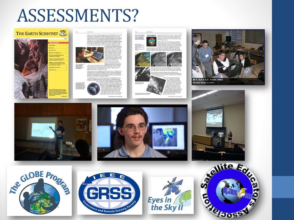
16 ASSESSMENTS?
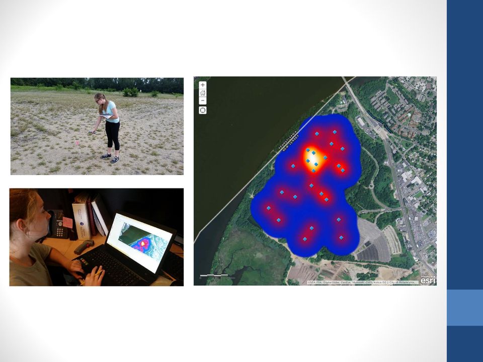
17 INTRODUCTION K-12 Students are given limited opportunity in the classroom to acquire and interpret geospatial information. The next generation science standards (NGSS) include earth system and real-time data; however, this is not yet fully realized in current school curricula. A future workforce trained in geospatial intelligence will be necessary to meet 21 st century challenges of a changing global environment. Applications of STEM education in Earth System - Earth SySTEM can be introduced into precollege to graduate curriculum to prepare students for these 21 st century geospatial intelligence skills. PURPOSE The purpose of this investigation is to demonstrate an application of Earth SySTEM that can be reproduced by K-12 teachers who have limited funding and IT support. The application is the creation of snow maps using free image processing software. A procedure has been documented and slated for publication in a future issue of The Earth Scientist, a quarterly journal by NESTA. FREE RESOURCES ImageJ and Multispec Software LandsatLookViewer (USGS) EOSDIS (NASA) THEORY NDSI = Sensors OLI & MODIS Snow is distinguished from water and clouds by thermal and reflectance properties. The Normalized Difference Snow Index (NDSI) is used to discriminate snow pixels from water, land, and cloud pixels. Application of Earth SySTEM in Establishing a Geospatial Intelligence Pipeline Kevin Varghese, Peter T. Dorofy, Rouzbeh Nazari PRODUCT The 0.6 µm green and short-wave infrared near 1.6 µm bands are used in the NDSI algorithm. Index values >= 0.4 are classified as snow pixels. ImageJ Snow Map Trial (California Coast) Multispec Snow Map (Novatek Glacier) OBSTACLES Clouds can have similar reflectance to snow, which makes classification difficult in images that are not cloud free. In the current model, water at times, is mistakenly represented in the snow maps, and may be a procedural error during image processing. A procedure needs to be created for precollege students. It is important students be engaged in the activity in order to develop young interest in remote sensing. CONCLUSIONS Discrimination of snow from land appears to work well; however, there persists a misclassification of pixels as snow, especially off the coast of California, where true color images reveal water. ImageJ was able to produce black and white snow maps that easily reveal areas of snow. Multispec produced greyscale images which makes it more difficult to differentiate snow from everything else; however, Multispec is better equipped to work with low level satellite data. FUTURE WORK In order to remove the water from snow maps, we have to remove all NDWI values from the image. Creating a threshold limit on the Multispec images are necessary to create black and white images representing only snow. Steps taken to create these snow maps need to be recorded for students to follow.

18 In 2012, New Jersey encountered Hurricane Sandy, a storm of historic proportions. The impacts were significant even though Sandy was classified as post- tropical cyclone as it made landfall. Hurricane Sandy was the 18th named tropical cyclone of the 2012 Atlantic hurricane season (June 1 November 30). Sandy formed in the central Caribbean on October 22nd and intensified into a hurricane as it tracked north across Jamaica, eastern Cuba and the Bahamas. Sandy moved northeast of the United States until turning west toward the mid-atlantic coast on the 28th. Sandy transitioned into a post-tropical cyclone just prior to moving onshore near Atlantic City, NJ (source: NWS). Buoy Data Satellite Imagery Hurricane Tracking Sea Surface Using Environmental Intelligence to Develop Resilience Strategies: Hurricane Sandy 2012 New Jersey M.Y.S.P.A.C.E. Team Google Earth overlay of Buoy locations and Sandy Track GOES 12 Image Analysis Using Image J software to approximate Radius of Maximum Winds (RMW) 29 Oct 2012, 1800 UT. *Formulas derived for this project were developed by Dr. S. A. Hsu, Louisiana State University Google Earth Sea Surface temperature overlay w/buoy and Sandy track Suomi NPP Visible Image Overlay in Google Earth showing Buoy, Sandy track. 29 Oct 2012, 1800 UT This project uses multiply sources of remote sensing data and scientific research to calculate the impacts of a hurricane wind field. Tropical stormforce winds are strong enough to be dangerous to those caught in them. For this reason, emergency managers plan on having their evacuations complete and their personnel sheltered before the onset of tropical storm-force winds, not hurricane-force winds Hurricane force winds, 74 mph or more, can destroy buildings and mobile homes. Debris, such as signs, roofing material, siding and small items left outside become flying missiles during hurricanes. Winds can stay above hurricane strength well inland. (source: National Hurricane Center). Through applications of physics principles and mathematical formulas*, students are able to calculate wind speeds throughout the hurricane s wind field. Remote Sensing data from NOAA s National Climatic Data Center, National Buoy Data Center, and the National Weather Service are all important data sets used in this project.

19
20 Making the Case for GeoSTEM Education John D. Moore An Opportunity for Innovation in STEM Education: GeoSTEM GeoSTEM: Establishing a Geoscience and Remote Sensing Laboratory Exploring New Frontiers in Earth System Education: GeoSTEM

Joint Polar Satellite System (JPSS)
") Joint Polar Satellite System (JPSS) John Furgerson, User Liaison Joint Polar Satellite System National Environmental Satellite, Data, and Information Service National Oceanic and Atmospheric Administration
Joint Polar Satellite System (JPSS) John Furgerson, User Liaison Joint Polar Satellite System National Environmental Satellite, Data, and Information Service National Oceanic and Atmospheric Administration
Environmental Data Services for Delaware:
 Environmental Data Services for Delaware: Serving Emergency Responders, Planners, and Researchers Network Delaware Day November 6, 2013 Overview Operational Data Services More than just research DEOS and
COASTAL MONITORING & OBSERVATIONS LESSON PLAN Do You Have Change?
 Coastal Change Analysis Lesson Plan COASTAL MONITORING & OBSERVATIONS LESSON PLAN Do You Have Change? NOS Topic Coastal Monitoring and Observations Theme Coastal Change Analysis Links to Overview Essays
How Landsat Images are Made
 How Landsat Images are Made Presentation by: NASA s Landsat Education and Public Outreach team June 2006 1 More than just a pretty picture Landsat makes pretty weird looking maps, and it isn t always easy
SCIENCE, TECHNOLOGY, ENGINEERING & MATHEMATICS (STEM)
") GENERAL POSITION PAPER STRENGTHENING PRE-COLLEGE SCIENCE, TECHNOLOGY, ENGINEERING & MATHEMATICS (STEM) EDUCATION IN THE U.S. PS14-23 SEPTEMBER 2014 GOVERNMENT RELATIONS 1828 L STREET NW, SUITE 810, WASHINGTON
GENERAL POSITION PAPER STRENGTHENING PRE-COLLEGE SCIENCE, TECHNOLOGY, ENGINEERING & MATHEMATICS (STEM) EDUCATION IN THE U.S. PS14-23 SEPTEMBER 2014 GOVERNMENT RELATIONS 1828 L STREET NW, SUITE 810, WASHINGTON
Land Use/Land Cover Map of the Central Facility of ARM in the Southern Great Plains Site Using DOE s Multi-Spectral Thermal Imager Satellite Images
 Land Use/Land Cover Map of the Central Facility of ARM in the Southern Great Plains Site Using DOE s Multi-Spectral Thermal Imager Satellite Images S. E. Báez Cazull Pre-Service Teacher Program University
354 Russell Senate Office Building 724 Hart Senate Office Building Washington, D.C. 20510 Washington, D.C. 20510
 The Honorable Cory Gardner The Honorable Gary Peters 354 Russell Senate Office Building 724 Hart Senate Office Building Washington, D.C. 20510 Washington, D.C. 20510 30 October 2015 Dear Senators Gardner
Review for Introduction to Remote Sensing: Science Concepts and Technology
 Review for Introduction to Remote Sensing: Science Concepts and Technology Ann Johnson Associate Director [email protected] Funded by National Science Foundation Advanced Technological Education program [DUE
[ Climate Data Collection and Forecasting Element ] An Advanced Monitoring Network In Support of the FloodER Program
![[ Climate Data Collection and Forecasting Element ] An Advanced Monitoring Network In Support of the FloodER Program](/thumbs/33/16326315.jpg "[ Climate Data Collection and Forecasting Element ] An Advanced Monitoring Network In Support of the FloodER Program") [ Climate Data Collection and Forecasting Element ] An Advanced Monitoring Network In Support of the FloodER Program December 2010 1 Introduction Extreme precipitation and the resulting flooding events
[ Climate Data Collection and Forecasting Element ] An Advanced Monitoring Network In Support of the FloodER Program December 2010 1 Introduction Extreme precipitation and the resulting flooding events
Geospatial Software Solutions for the Environment and Natural Resources
 Geospatial Software Solutions for the Environment and Natural Resources Manage and Preserve the Environment and its Natural Resources Our environment and the natural resources it provides play a growing
163 ANALYSIS OF THE URBAN HEAT ISLAND EFFECT COMPARISON OF GROUND-BASED AND REMOTELY SENSED TEMPERATURE OBSERVATIONS
 ANALYSIS OF THE URBAN HEAT ISLAND EFFECT COMPARISON OF GROUND-BASED AND REMOTELY SENSED TEMPERATURE OBSERVATIONS Rita Pongrácz *, Judit Bartholy, Enikő Lelovics, Zsuzsanna Dezső Eötvös Loránd University,
SIXTH GRADE WEATHER 1 WEEK LESSON PLANS AND ACTIVITIES
 SIXTH GRADE WEATHER 1 WEEK LESSON PLANS AND ACTIVITIES WATER CYCLE OVERVIEW OF SIXTH GRADE WATER WEEK 1. PRE: Evaluating components of the water cycle. LAB: Experimenting with porosity and permeability.
USING THE GOES 3.9 µm SHORTWAVE INFRARED CHANNEL TO TRACK LOW-LEVEL CLOUD-DRIFT WINDS ABSTRACT
 USING THE GOES 3.9 µm SHORTWAVE INFRARED CHANNEL TO TRACK LOW-LEVEL CLOUD-DRIFT WINDS Jason P. Dunion 1 and Christopher S. Velden 2 1 NOAA/AOML/Hurricane Research Division, 2 UW/CIMSS ABSTRACT Low-level
Ensuring the Preparedness of Users: NOAA Satellites GOES R, JPSS Laura K. Furgione
 Ensuring the Preparedness of Users: NOAA Satellites GOES R, JPSS Laura K. Furgione U.S. Permanent Representative with the WMO Deputy Director, NOAA s s National Weather Service WMO Executive Council 65
Assessing Hurricane Katrina Damage to the Mississippi Gulf Coast Using IKONOS Imagery
 Assessing Hurricane Katrina Damage to the Mississippi Gulf Coast Using IKONOS Imagery Joseph P. Spruce Science Systems and Applications, Inc. John C., MS 39529 Rodney McKellip NASA Project Integration
MiSP WEATHER WIND SPEED AND DIRECTION Teacher Guide, L1 L3. Introduction
 MiSP WEATHER WIND SPEED AND DIRECTION Teacher Guide, L1 L3 Introduction This MiSP unit can be included in a standard weather and climate unit. Some teachers may like it as part of the introduction. Others
Follow That Hurricane!
 Discover Your World With NOAA Follow That Hurricane! What You Will Do Devastating damage expected A most Track a hurricane on the same powerful hurricane with unprecedented type of chart used at the strength
CHAPTER 2 Energy and Earth
 CHAPTER 2 Energy and Earth This chapter is concerned with the nature of energy and how it interacts with Earth. At this stage we are looking at energy in an abstract form though relate it to how it affect
THE STRATEGIC PLAN OF THE HYDROMETEOROLOGICAL PREDICTION CENTER
 THE STRATEGIC PLAN OF THE HYDROMETEOROLOGICAL PREDICTION CENTER FISCAL YEARS 2012 2016 INTRODUCTION Over the next ten years, the National Weather Service (NWS) of the National Oceanic and Atmospheric Administration
21st Education Symposium AMS 92nd New Orleans, LA 24 January 2012 With thanks to: Image Acknowledgements: ç The Leviathan, from friedpost.
 The Return of the Mini-Course: Online and Field-Based Applied Meteorology for Majors Paul Ruscher Department of Earth, Ocean and Atmospheric Science Florida State University Tallahassee Image Acknowledgements:
Received in revised form 24 March 2004; accepted 30 March 2004
 Remote Sensing of Environment 91 (2004) 237 242 www.elsevier.com/locate/rse Cloud detection in Landsat imagery of ice sheets using shadow matching technique and automatic normalized difference snow index
NASA s Big Data Challenges in Climate Science
 NASA s Big Data Challenges in Climate Science Tsengdar Lee, Ph.D. High-end Computing Program Manager NASA Headquarters Presented at IEEE Big Data 2014 Workshop October 29, 2014 1 2 7-km GEOS-5 Nature Run
Hyperspectral Satellite Imaging Planning a Mission
 Hyperspectral Satellite Imaging Planning a Mission Victor Gardner University of Maryland 2007 AIAA Region 1 Mid-Atlantic Student Conference National Institute of Aerospace, Langley, VA Outline Objective
A remote sensing instrument collects information about an object or phenomenon within the
 Satellite Remote Sensing GE 4150- Natural Hazards Some slides taken from Ann Maclean: Introduction to Digital Image Processing Remote Sensing the art, science, and technology of obtaining reliable information
Hurricanes. Characteristics of a Hurricane
 Hurricanes Readings: A&B Ch. 12 Topics 1. Characteristics 2. Location 3. Structure 4. Development a. Tropical Disturbance b. Tropical Depression c. Tropical Storm d. Hurricane e. Influences f. Path g.
DIABLO VALLEY COLLEGE CATALOG 2015-2016
 GEOGRAPHY GEOG Tish Young, Dean Physical Sciences and Engineering Division Physical Sciences Building, Room 263 Possible career opportunities Geography is an interdisciplinary study focusing on the spatial
LEOworks - a freeware to teach Remote Sensing in Schools
 LEOworks - a freeware to teach Remote Sensing in Schools Wolfgang Sulzer Institute for Geography and Regional Science University of Graz Heinrichstrasse 36, A-8010 Graz/Austria [email protected]
Savannah State University. STEM Programs, Scholarships, and Internships Presented by Dr. Marilyn Hutchinson Director, Mentoring and Research Programs
 Savannah State University STEM Programs, Scholarships, and Internships Presented by Dr. Marilyn Hutchinson Director, Mentoring and Research Programs Savannah State University Savannah State University
Hurricanes and Storm Surge www.hcfcd.org/tropicalweather
 Hurricanes and Storm Surge www.hcfcd.org High-level winds fl ow outward Strong surface winds spiral inward EYE Calm, sometimes cloudfree, sinking air Air sinks in calm area at the storm s eye THUNDERSTORMS
Cover Sheet. Geography B.A. via UF Online for Fall 2015. Info Program Modify Platform Ugrad/Pro
 Cover Sheet Geography B.A. via UF Online for Fall 2015 Info Process Status Submitter Created Updated Description Program Modify Platform Ugrad/Pro Pending Collis,Lynne N [email protected] 10/8/2014 3:41:08
ENVI THE PREMIER SOFTWARE FOR EXTRACTING INFORMATION FROM GEOSPATIAL IMAGERY.
 ENVI THE PREMIER SOFTWARE FOR EXTRACTING INFORMATION FROM GEOSPATIAL IMAGERY. ENVI Imagery Becomes Knowledge ENVI software uses proven scientific methods and automated processes to help you turn geospatial
Building Science and Engineering Talent. SEA Qualification Statement
 "A Unique Resource for the Nation" Building Science and Engineering Talent SEA Qualification Statement Background and Need Science, mathematics, and engineering education in many countries is essential
Mission and Goals Statement. University of Maryland, College Park. January 7, 2011
 Summary of Mission Statement Mission and Goals Statement University of Maryland, College Park January 7, 2011 The mission of the University of Maryland, College Park is to provide excellence in teaching,
Clouds and the Energy Cycle
 August 1999 NF-207 The Earth Science Enterprise Series These articles discuss Earth's many dynamic processes and their interactions Clouds and the Energy Cycle he study of clouds, where they occur, and
7) Coastal Storms: Multi-Hazard Analysis for New York City
 Coastal Storms: Multi-Hazard Analysis for New York City") 7) Coastal Storms: Multi-Hazard Analysis for New York City a) Hazard Profile i) Hazard Description Coastal storms, including nor'easters, tropical storms, and hurricanes, can and do affect New York City.
7) Coastal Storms: Multi-Hazard Analysis for New York City a) Hazard Profile i) Hazard Description Coastal storms, including nor'easters, tropical storms, and hurricanes, can and do affect New York City.
NASA's Strategy and Activities in Server Side Analytics
 NASA's Strategy and Activities in Server Side Analytics Tsengdar Lee, Ph.D. High-end Computing Program Manager NASA Headquarters Presented at the ESGF/UVCDAT Conference Lawrence Livermore National Laboratory
NAGT Who are we? http://nagt.org
 NAGT Who are we? http://nagt.org by Janis D. Treworgy President of NAGT 2010 2011 Professor of Geology Principia College, Elsah, IL [email protected] As professional geoscientists, you may daily
Improved Warnings for Natural Hazards: A Prototype System for Southern California
 Improved Warnings for Natural Hazards: A Prototype System for Southern California Yehuda Bock Research Geodesist Scripps Institution of Oceanography University of California San Diego, La Jolla, Calif.
Automated Spacecraft Scheduling The ASTER Example
 Automated Spacecraft Scheduling The ASTER Example Ron Cohen [email protected] Ground System Architectures Workshop 2002 Jet Propulsion Laboratory The Concept Scheduling by software instead of
Cloud-based Geospatial Data services and analysis
 Cloud-based Geospatial Data services and analysis Xuezhi Wang Scientific Data Center Computer Network Information Center Chinese Academy of Sciences 2014-08-25 Outlines 1 Introduction of Geospatial Data
Name Period 4 th Six Weeks Notes 2015 Weather
 Name Period 4 th Six Weeks Notes 2015 Weather Radiation Convection Currents Winds Jet Streams Energy from the Sun reaches Earth as electromagnetic waves This energy fuels all life on Earth including the
INVESTIGA I+D+i 2013/2014
 INVESTIGA I+D+i 2013/2014 SPECIFIC GUIDELINES ON AEROSPACE OBSERVATION OF EARTH Text by D. Eduardo de Miguel October, 2013 Introducction Earth observation is the use of remote sensing techniques to better
Design and Deployment of Specialized Visualizations for Weather-Sensitive Electric Distribution Operations
 Fourth Symposium on Policy and Socio-Economic Research 4.1 Design and Deployment of Specialized Visualizations for Weather-Sensitive Electric Distribution Operations Lloyd A. Treinish IBM, Yorktown Heights,
NASA Earth System Science: Structure and data centers
 SUPPLEMENT MATERIALS NASA Earth System Science: Structure and data centers NASA http://nasa.gov/ NASA Mission Directorates Aeronautics Research Exploration Systems Science http://nasascience.nasa.gov/
How do abiotic factors and physical processes impact life in the ocean?
 This website would like to remind you: Your browser (Apple Safari 7) is out of date. Update your browser for more security, comfort and the best experience on this site. Activitydevelop Ocean Abiotic Factors
Jessica Blunden, Ph.D., Scientist, ERT Inc., Climate Monitoring Branch, NOAA s National Climatic Data Center
 Kathryn Sullivan, Ph.D, Acting Under Secretary of Commerce for Oceans and Atmosphere and NOAA Administrator Thomas R. Karl, L.H.D., Director,, and Chair of the Subcommittee on Global Change Research Jessica
Landsat Monitoring our Earth s Condition for over 40 years
 Landsat Monitoring our Earth s Condition for over 40 years Thomas Cecere Land Remote Sensing Program USGS ISPRS:Earth Observing Data and Tools for Health Studies Arlington, VA August 28, 2013 U.S. Department
Evaluation of the Effect of Upper-Level Cirrus Clouds on Satellite Retrievals of Low-Level Cloud Droplet Effective Radius
 Evaluation of the Effect of Upper-Level Cirrus Clouds on Satellite Retrievals of Low-Level Cloud Droplet Effective Radius F.-L. Chang and Z. Li Earth System Science Interdisciplinary Center University
NCDC Strategic Vision
 NOAA s National Climatic Data Center World s Largest Archive of Climate and Weather Data Presented to: Coastal Environmental Disasters Data Management Workshop September 16, 2014 Stephen Del Greco Deputy
Strategic Initiatives College of Science, August, 2004
 College of Science Strategic Initiatives College of Science, August, 2004 MISSION: To graduate students who understand and appreciate the art of scholarship, who have an excellent grasp of the fundamental
NOAA NATIONAL SEA GRANT COLLEGE PROGRAM 2014 2017 STRATEGIC PLAN
 NOAA NATIONAL SEA GRANT COLLEGE PROGRAM 2014 2017 STRATEGIC PLAN Sustaining our nation s ocean, coastal and Great Lakes resources through university based research, communications, education, extension
Green Education through Green Power: Photovoltaics as a Conduit to Interdisciplinary Learning
 Green Education through Green Power: Photovoltaics as a Conduit to Interdisciplinary Learning The proposed project will enable ABC University to: 1) develop an interdisciplinary educational program to
Exploring Florida: Teaching Resources for Science 1 of 6
 Exploring Florida: Teaching Resources for Science 1 of 6 Tropical Cyclones This document describes tropical cyclones and the dangers they pose to coastal populations. It is intended to help teachers improve
Storm tide is the water level rise during a storm due to the combination of storm surge and the astronomical tide.
 INTRODUCTION TO STORM SURGE Introduction to Storm Surge BOLIVAR PENINSULA IN TEXAS AFTER HURRICANE IKE (2008) What is Storm Surge? Inland Extent Storm surge can penetrate well inland from the coastline.
Content Guide & Five Items Resource
 Content Guide & Five Items Resource Introduction The following information should be used as a companion to the CPI Links. It provides clarifications concerning the content and skills contained in the
Heavy Rainfall from Hurricane Connie August 1955 By Michael Kozar and Richard Grumm National Weather Service, State College, PA 16803
 Heavy Rainfall from Hurricane Connie August 1955 By Michael Kozar and Richard Grumm National Weather Service, State College, PA 16803 1. Introduction Hurricane Connie became the first hurricane of the
CRS 610 Ventura County Flood Warning System Website
 CRS 610 Ventura County Flood Warning System Website Purpose This document gives instructions and a description of the information available via the Ventura County Watershed Protection District s (VCWPD)
Curriculum Material and Activities of Climate Education:
 Curriculum Material and Activities of Climate Education: Education Link Website Union of Concerned Scientists develop the global warming: Early Warning Signs Map a science-based world map depicting the
GLOBAL FORUM London, October 24 & 25, 2012
 GLOBAL FORUM London, October 24 & 25, 2012-1 - Global Observations of Gas Flares Improving Global Observations of Gas Flares With Data From the Suomi NPP Visible Infrared Imaging Radiometer Suite (VIIRS)
5. PROFESSIONAL SERVICES
 Joseph B. Zambon Department of Marine, Earth and Atmospheric Sciences, North Carolina State University Jordan Hall Rm. 4133, Raleigh, North Carolina 27695-8208 Tel: 716.435.9707; Email: [email protected];
Hurricanes: Nature's Wildest Storms by Erin Ryan
 Name: : Nature's Wildest Storms by Erin Ryan You may already know that hurricanes are major tropical storms that can cause devastating waves, wind, and rain. They happen during Hurricane Season, which
Storm tide is the water level rise during a storm due to the combination of storm surge and the astronomical tide.
 INTRODUCTION TO STORM SURGE Introduction to Storm Surge National Hurricane Center Storm Surge Unit BOLIVAR PENINSULA IN TEXAS AFTER HURRICANE IKE (2008) What is Storm Surge? Inland Extent Storm surge can
Slide 1. Slide 2. Slide 3
 Satellite Analysis of Sea Surface Temperatures in the Florida Keys to Monitor Coral Reef Health NASA Stennis Space Center Earthzine/DEVELOP Virtual Poster Session, Summer 2011 Video Transcript Slide 1
WEATHER AND CLIMATE practice test
 WEATHER AND CLIMATE practice test Multiple Choice Identify the choice that best completes the statement or answers the question. 1. What role does runoff play in the water cycle? a. It is the process in
Geography. LOWER-DIVISION TRANSFER PATTERN California State University (CSU) Statewide Pattern
 Statewide Pattern") August 20, 2009 California State University (CSU) Statewide Pattern The Lower-Division Transfer Pattern (LDTP) consists of the CSU statewide pattern of coursework outlined below, plus campus-specific coursework,
August 20, 2009 California State University (CSU) Statewide Pattern The Lower-Division Transfer Pattern (LDTP) consists of the CSU statewide pattern of coursework outlined below, plus campus-specific coursework,
Selecting the appropriate band combination for an RGB image using Landsat imagery
 Selecting the appropriate band combination for an RGB image using Landsat imagery Ned Horning Version: 1.0 Creation Date: 2004-01-01 Revision Date: 2004-01-01 License: This document is licensed under a
Satellite'&'NASA'Data'Intro'
 Satellite'&'NASA'Data'Intro' Research'vs.'Opera8ons' NASA':'Research'satellites' ' ' NOAA/DoD:'Opera8onal'Satellites' NOAA'Polar'Program:'NOAA>16,17,18,19,NPP' Geosta8onary:'GOES>east,'GOES>West' DMSP'series:'SSM/I,'SSMIS'
What is spectrum reallocation, and what does it have to do with weather satellites?
 FAQ ========= SPECTRUM REALLOCATION ========= What is spectrum reallocation, and what does it have to do with weather satellites? Because of increasing demand for wireless smartphones, tablets, and Wi-Fi
TerraColor White Paper
 TerraColor White Paper TerraColor is a simulated true color digital earth imagery product developed by Earthstar Geographics LLC. This product was built from imagery captured by the US Landsat 7 (ETM+)
http://www.nrl.navy.mil/pao/pressrelease.php?y=2008&r=91-08r
 Page 1 of 7 NRL Press Release 91-08r 12/15/2008 [email protected] 202-767-2541 NRL's P-3 Aircraft Support Project to Study Tropical Cyclones Email Follow NRL RSS Feed Related Visuals The Naval Research
145,000+ Royalty-Free Maps for the K-12, Academic, and Library Markets. Digital media by:
 145,000+ Royalty-Free Maps for the K-12, Academic, and Library Markets Digital media by: AtoZ Maps Online AtoZ Maps Online remains without peer as the most comprehensive map resource database available
Overview of the IR channels and their applications
 Ján Kaňák Slovak Hydrometeorological Institute [email protected] Overview of the IR channels and their applications EUMeTrain, 14 June 2011 Ján Kaňák, SHMÚ 1 Basics in satellite Infrared image interpretation
DIABLO VALLEY COLLEGE CATALOG 2016-2017
 Geography GEOGRAPHY GEOG Tish Young, Dean Physical Sciences and Engineering Division Physical Sciences Building, Room 263 Possible career opportunities Geography is an interdisciplinary study focusing
Engineering our Future New Jersey: Partnerships, the Critical Element
 Engineering our Future New Jersey: Partnerships, the Critical Element Elisabeth McGrath, Stevens Institute of Technology Dawna Schultz, Stevens Institute of Technology Abstract: Engineering Our Future
Geography affects climate.
 KEY CONCEPT Climate is a long-term weather pattern. BEFORE, you learned The Sun s energy heats Earth s surface unevenly The atmosphere s temperature changes with altitude Oceans affect wind flow NOW, you
Critical Need to Rebuild Atlantic City and Protect Vulnerable Environmental Justice Populations Affected by Hurricane Sandy
 Critical Need to Rebuild Atlantic City and Protect Vulnerable Environmental Justice Populations Affected by Hurricane Sandy Presented by: Roy L. Jones, Executive Director, National Institute for Healthy
The Arctic Observing Network and its Data Management Challenges Florence Fetterer (NSIDC/CIRES/CU), James A. Moore (NCAR/EOL), and the CADIS team
, James A. Moore (NCAR/EOL), and the CADIS team") The Arctic Observing Network and its Data Management Challenges Florence Fetterer (NSIDC/CIRES/CU), James A. Moore (NCAR/EOL), and the CADIS team Photo courtesy Andrew Mahoney NSF Vision What is AON? a
The Arctic Observing Network and its Data Management Challenges Florence Fetterer (NSIDC/CIRES/CU), James A. Moore (NCAR/EOL), and the CADIS team Photo courtesy Andrew Mahoney NSF Vision What is AON? a
EPA Trends for wastewater Treatment in California - 2011
 EPA S TECHNOLOGY NEEDS FOR THE WATER AND WASTEWATER INDUSTRY Nancy Stoner Acting Assistant Administrator U.S. EPA Office of Water International Emerging Technology Symposium Arlington, VA April 23rd, 2014
Southern AER Atmospheric Education Resource
 Southern AER Atmospheric Education Resource Vol. 9 No. 5 Spring 2003 Editor: Lauren Bell In this issue: g Climate Creations exploring mother nature s remote control for weather and Climate. g Crazy Climate
Julie Pullen, CSR Director Stevens Institute of Technology
 The Center for Secure and Resilient Maritime Commerce (CSR) A DHS National Center of Excellence for Maritime Security Research & Education Overview Julie Pullen, CSR Director Stevens Institute of Technology
The premier software for extracting information from geospatial imagery.
 Imagery Becomes Knowledge ENVI The premier software for extracting information from geospatial imagery. ENVI Imagery Becomes Knowledge Geospatial imagery is used more and more across industries because
The Next Generation Science Standards (NGSS) Correlation to. EarthComm, Second Edition. Project-Based Space and Earth System Science
 Correlation to. EarthComm, Second Edition. Project-Based Space and Earth System Science") The Next Generation Science Standards (NGSS) Achieve, Inc. on behalf of the twenty-six states and partners that collaborated on the NGSS Copyright 2013 Achieve, Inc. All rights reserved. Correlation to,
The Next Generation Science Standards (NGSS) Achieve, Inc. on behalf of the twenty-six states and partners that collaborated on the NGSS Copyright 2013 Achieve, Inc. All rights reserved. Correlation to,
Forecast-Informed Reservoir Operations: A Concept Supporting Water Supply and Flood Control
 16 inches of rain in 1 day in Central California Forecast-Informed Reservoir Operations: A Concept Supporting Water Supply and Flood Control Developed by the Center for Western Weather and Water Extremes
Geospatial Information for disaster risk reduction and natural resources management. Rolando Ocampo Alcántar
 Geospatial Information for disaster risk reduction and natural resources management Rolando Ocampo Alcántar Content Background Geospatial Information for Disaster Management Risk Atlas Information Exchange
How To Find Out If The Winds From The Oak Ridge Site Are Calm
 EVALUATING THE WIND DATA FROM THE AUTOMATED SURFACE OBSERVING SYSTEM IN OAK RIDGE, TENNESSEE - IS KOQT THE CALMEST SITE IN THE US? Thomas E. Bellinger, CCM Y-12 National Security Complex Oak Ridge, Tennessee