SAC-C MISSION 2.0 CONAE INSTRUMENTS DESCRIPTION 2.1 MMRS
|
|
|
- Annabel Marianna Tucker
- 9 years ago
- Views:
Transcription
1 SAC-C MISSION Carlos Alonso Carlos Hofmann SAC-C Program Manager SAC-C System Engineer CONAE (Comisión Nacional de Actividades Espaciales), Paseo Colón 751 (1063) Buenos Aires Argentina 1 Abstract. SAC-C is an international project led by CONAE (Comisión Nacional de Actividades Espaciales) of Argentina and NASA from the United States of America. Others countries like Italy, France, Brazil and Denmark also participate in the project. These countries participate in different ways, some of them developing instruments and others are more interested in SAC-C science and contributing to project development. SAC-C is the first Argentinean Earth Observation Satellite and it has been designed primary to fulfil the requirements of large countries with small population like Argentina. Its design is a good compromise between resolution and swath width that permits SAC-C to be an appropriate tool for global and high dynamic phenomena study. Large coverage, multispectral and panchromatic capabilities, medium ground resolution and short revisit time are its main characteristics. SAC-C has been launch on November 21 st 2000 from the Vandenberg Air Force Base, in California on a Delta II launcher. Currently SAC-C is performing nominal mission operations from mid-april The objectives of the SAC-C Mission, as well as particularities of the satellite design and programmatic considerations are presented in this paper. 1.0 Mission Objectives SAC-C Mission is basically an earth observation mission. There are nine instruments that will perform several studies. The MMRS (Multispectral Medium Resolution Scanner), provided by CONAE, Argentina, permits the study of desertification processes and their evolution in time (i.e. Patagonia, Argentina), to identify and predict agriculture production, to monitor flooded areas and to make studies in coastal and fluvial areas. The MMRS is associated with a High Resolution Camera (HRTC), provided also by CONAE, which permits improvement of the MMRS resolution on the areas where it is required. These two cameras are complemented with the HSTC, a high sensitivity camera for atmospherics research. The Whale Tracker, developed by CONAE and the Secretary of Environment of Argentina, will permit the study of the migration pattern and behavior of the Eubalanea Australis; the goal is to protect this specie from depredation. The same instrument will permit the collection of environmental data from platforms on ground. The instrument will be able to track whales from mid A GPS, provided by NASA JPL, is used to measure the long wavelength component of Earth s gravity field and to measure the refractivity of GPS signals as occulted by the Earth atmosphere and ionosphere. Others studies are being performed to observe reflection of GPS signals from the ocean surface for estimating capabilities for altimetric and ionospheric science. The MMP (Magnetic Mapping Payload), developed by the Danish Space Research Institute and NASA JPL, performs observatory quality measurements of the magnetic field. It consists of both vector and scalar magnetometers. The vector magnetometer is associated with a star imager to determine its pointing direction. ICARE (Influence of Space Radiation on Advance Components), provided by CNES from France, permits the improvement of risk estimation models for radiation effects on latest generations of integrated circuits technologies and to improve environment models for radiation responsible for degradations in electronic components. AADS and INES (Autonomous Attitude Determination From Stars and Italian Navigation Experiment), developed by the Italian Space Agency, constitute a technological payload that permits the testing of a fully autonomous system for attitude and orbit determination using a new generation star tracker and a GPS/GLONASS system receiver. 2.0 CONAE INSTRUMENTS DESCRIPTION 2.1 MMRS 1 CONAE Tel: / / Fax: ext [email protected] /

2 The MMRS is a multispectral camera with 5 spectral bands: B1: nm Blue greenish B2: nm Green B3: nm Red B4: nm NIR B5: nm SWIR The MMRS has two operational modes, a highresolution mode of 175 meters and a low-resolution mode of 350 meters. For the first case the MMRS can operate in real time at a bit rate of Mbit/sec and also can store data in its own memory with an image dimension of 360km x 8000km, depending on the data compression ratio. For the low-resolution mode the MMRS transmits in real time at a bit rate of 0.943Mbit/sec. The low-resolution images are transmitted in real time. Small users, research institutes, Universities and schools use these images. The following are the main MMRS characteristics: Total Mass 22kg. Power Consumption 25Watts (peak) Spectral Bands 5 Down link bit rate 3.774/0.943 Mbit/sec Memory Capacity 96Mbytes On board compressor JPEG rev 08 Expected Compression Rate a) Real Time 4:1 b) Stored Mode worst/best 4:1/10:1 Ground Pixel size 175 meters Swath Width 360 km CCD s 4Xvnir Xswir 2100 Gain steps Programmable Integration Time Programmable Radiometric Resolution Corregistration among bands 8 bits +/- 2 pixels (life time) +/ pixel (one orbit) 2.2 HRTC The HRTC (High Resolution Technological Camera) is a panchromatic camera with a ground resolution of 35 meters. The spectral response is in the range of 400 to 900nm. The HRTC have two operational modes, stored data or real time transmission. It records the images in its own mass memory 96 Mbytes of capacity. The image size is 90km x 1150km. The HRTC main characteristics are: Total Mass 8.5 kg. Power Consumption 10.5 Watts Down link bit rate Mbit/sec. Ground pixel size 35 meters Swath width 90 km CCD Loral Fairchild CCD181 Nº of pixels 2592 Gain steps Programmable Integration time Programmable Radiometric Resolution 8 bits IFOV deg. FOV 7 deg. Operating Mode Stored Mass Memory 96 Mbytes 2.3 Data Collection System / Whale Tracker The Data Collection System / Whale Tracker experiment is a joint project between the Secretaría de Recursos Naturales y Desarrollo Sustentable y CONAE. The instrument has two modules: the Data Module and the Satellite Module. The Data Module, developed to be installed on a number of whales or as fixed platforms on ground, includes a GPS to determine position and absolute time and transducers to measure water temperature, pressure and environmental data. A transmitter and a data management unit complete the Data Modules system. All data received by the Satellite module is stored in the satellite Mass Memory and dumped every day during the nighttime passes. The Satellite Module on board the SAC-C satellite consists of a receiver to acquire data transmitted from the Data Modules and the necessary logic to handle data acquired. The instrument is currently used to collect data from Data Collection Platforms to monitor environment and meteorological data. 3.0 SATELLITE DESCRIPTION The SAC-C satellite has been designed for a minimum lifetime of 4 years. The maximum SAC-C injected mass was 475kg, including 12.5kg of hydrazine. SAC-C is a three axis stabilised spacecraft (earth pointed). Pointing accuracy is 0.2deg, pointing stability 0.003deg/sec and pointing knowledge accuracy 70arcsec (3σ) on the three axis. The orbit characteristics are:

3 Nominal altitude 707km Inclination 98.2deg Track error +/-10km EOL. Revisit Time 16 days The magnetic cleanliness achieved at 8 meter is better than 1nT (at the scalar magnetometer distance), required to have an appropriate magnetic cleanliness valid for the mission. The main satellite subsystems are: Structures and Thermal Control Command & Data Handling Attitude Control & Orbit Control Power Communications (RF) 3.1 STRUCTURE AND THERMAL S/S Structure Main structure is manufactured in aluminium. Antennas booms are manufactured in carbon fibre reinforced plastic and the batteries mounting frames in titanium. The structure subsystem has been design to carry 475kg. The subsystem mass is 65kg. SAC-C envelope in launch configuration was 1.85x1.68x2.4meters. The stiffness requirements were: First lateral natural frequency higher than 20Hz. First axial natural frequency higher than 35Hz SAC-C first natural frequencies were: Lateral 39.3Hz Axial: 41.7Hz Thermal Control The thermal control design implementation is based on MLI, Radiators and Heaters. The spacecraft bus is divided into three areas for their thermal control: the main room, the batteries environment, and the propulsion system. The main room uses radiators and an active system with heaters. The philosophy design is based on a power budget of 0 Watts. Main room thermal control is designed to maintain the temperature inside the required ranges using only the power excess and the equipment dissipation. The MMRS and the HRTC cameras have their own thermal control system. The operative and non-operative temperature ranges are: Main Room Op:-10/+40 Non-op:-20/+50 Batteries Op:-10/+5 Non-op: N.A. Propulsion System Op:+10/+40 Non-op: N.A. MMRS Op:-7/+7 Non-op:-20/+50 HRTC Op:-7/+40 Non-op:-20/ COMMAND & DATA HANDLING S/S The Command & Data Handling subsystem main features are, to receive, decode and execute commands in real time or time tagged, to read telemetry data, to supervise subsystems behaviour and to store telemetry and instruments data on the Mass Memory Unit. It consists of three units, the command and data handling unit, the payloads communication hub unit and the Mass Memory Unit. (see Fig-3) The command and data-handling unit includes two redundant units in the same box, in cold configuration. It has the capability for automatically switching through a dedicated watchdog type redundant hardware. Ground switching is also implemented through hard-commands. All internal communications are through a MIL STD 1553B bus. The Communications Hub unit was included to manage the payloads that required the use of the RS 422 interface. It consists of two redundant units in cold backup configuration; the interface with C&DH is through the MIL STD 1553B and with the payloads through the RS 422 at 9600 baud. The Mass memory Unit consists of two redundant units of 96Mbytes each. They could be in cold backup configuration or in use simultaneously, increasing the memory capability up to 192Mbytes. Housekeeping and scientific instrument data, excluding the MMRS, HSTC and HRTC cameras, is stored in the mass memory unit The mass memory unit includes also the function for down linking information from scientific instruments, cameras (real time and storage data) and Housekeeping. The MMRS, HSTC and HRTC cameras have access directly to the mass memory down linking electronics. It also codes the information to be transmitted using convolutional coding. 3.3 COMMUNICATIONS S/S The RF subsystem has been implemented to have the capability to: Receive commands (real time or time tagged) Transmit telemetry (real time and housekeeping) Transmit science data (recorded and in real time) The main components of the RF subsystem are: Two S Band command receivers (4Kbps up-link) in hot backup configuration, cross-strapped to both C&DH units. Two S Band transmitters (1Kbps downlink) of 1/0.1 Watts (switchable by command), for real time telemetry.

4 Two dedicated S Band 5Watts transmitter for MMRS low-resolution images in real time (0.9435Mbps) and Mass Memory data transmission (1.887Mbps). Two X Band 3 Watts transmitters for MMRS High Resolution real time and stored images and HRTC stored images. The bit rate is Mbps for all cases. The main components of the Orbit Control Subsystem are: 8 thrusters in dual configurations 1 hydrazine tank (12.5kg.) 2 latch valves 1 filter fill and drain valves Redundant driver electronics 3.4 ATTITUDE AND ORBIT CONTROL S/S SAC-C is a three axis stabilised spacecraft (earth pointed). It will use dedicated sensors and actuator for the attitude control. Only in emergency cases would it be possible to use the propulsion system (orbit control s/s) for that task. The main components of the Attitude Control Subsystem are: Sensors: Star Tracker Coarse solar sensor Two Scanwheels Two Tri-axial Magnetometers GPS for orbit and attitude determination Actuators Three redundant torque rods. Two Momentum wheels Thrusters (in case of emergencies) Magnetic Mapping Payload Boom (8 meter boom) The Attitude Control Electronics (ACE) includes two redundant units in cold backup configuration. Pointing accuracy is 0.2deg, pointing stability 0.003deg/sec and pointing knowledge accuracy 70arcsec (3σ) on the three axis. The Orbit Control Subsystem main functions are orbit injection error correction manoeuvres and orbit maintenance. The system consist of four dual thrusters pointing in the velocity vector negative direction (there is a small tilt to provide torque around the three satellite axis). The satellite centre of mass is inside of the rectangle defined by the four thrusters. The Orbit Control subsystem works in closed loop with the Attitude Control Electronics. In this way, using an off modulation concept, it is possible to maintain the satellite attitude within the 5 degree from the nominal attitude. The Orbit Control subsystem operates, like baseline, using one of the two branches of four thruster. In case of failure or malfunction of the operative branch the system selects the other branch. In case of need both branches could be operated together. 3.5 POWER S/S The Power subsystem main functions are: to provide power distribution to the spacecraft bus and payloads, to measure load s current, to provide batteries thermal control and charge control, to limit bus voltage, to generate telemetry and to transmit it to C&DH through the MIL STD 1553B communication bus. The main components of the power subsystem are: Solar Panels 2 Nickel Hydrogen batteries (12Am/h) two Power Control Electronics in hot backup configuration The solar panels consist of two fixed wings with four panels each with different inclination with respect to the sun in order to have a power generation without excessive peaks of power. They are attached to the satellite body by one hinge per wing when deployed. (See Fig.1) The average power generated during sunlight is of 460 Watts. The orbital power consumption is Watts. 4.0 GROUND SEGMENT The SAC-C Ground Segment is located at the CONAE Center in Córdoba Argentina. A dedicated S Band antenna is used for T&TC and Mass Memory data down link. Other dedicated X Band antennae are used to receive high-resolution MMRS real time and storage images and HRTC images. 5.0 PROGRAMMATIC CHARACTERISTICS SAC-C is a co-operative program between the Comisión Nacional de Actividades Espaciales (CONAE) from Argentina and the National Aeronautics and Space Administration (NASA) from the United States. By mean of this agreement CONAE provides the spacecraft platform and three scientific instruments and NASA provides launch services and two scientific instruments. CONAE signed agreements with other space agencies to provide additional instruments valid for the SAC-C Mission.
. It will use dedicated sensors and actuator for the attitude control.")
5 In this way Italy provided two instruments and contributed with the program by supplying the solar panels design and a GPS tensor that is used by the bus for navigation and timing determination. Danish Space Research Institute provided part of the MMP payload and the 8 meter boom, CNES from France provided the ICARE instrument and INPE/LIT from Brazil provided its testing facilities for SAC-C structure and thermal subsystems qualification and system level test. For SAC-C development CONAE selected as prime contractor the company INVAP S.E. from Bariloche Argentina. SAC-C has been launched on November 21 st, 2001 from the Vandenberg Base, California (USA) with a Delta 7320 in a dual launch with the EO1 satellite from the NASA Goddard Space Flight Center.

6 Fig 1 Orbit Configuration Fig 2 Block Diagram SW2 SW1 TAM X,Y,Z CSS POWER ACS C&DH MM PROPULSION SYSTEM x2 x2 x2 SYSTEM SOL PAN BATT1&2 PDU 1553B CHU GPS LAGRANGE SAC-C ITALIAN STAR TRACKER S-BAND1 TXRX S-BAND1 TX RS422 S-BAND2 TXRX S-BAND2 TX MMP JPLGPS STAR TRACKER GPS TENSOR COMRAD VM UHF TXRX WHALE TRACKER X-BAND1 TX ST T SHM X-BAND2 TX HRTC MMRS UHF RX

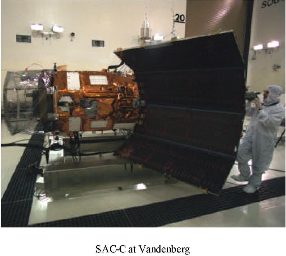
7 SAC-C at Vandenberg
8

Quest- 1 Satellite Functional Description
 Quest- 1 Satellite Functional Description Overview The Quest- 1 Satellite is based on the CubeSat Standard that measures 10 cm x 10 cm x 10 cm and weighs less than 1.33 kilograms. The Quest- 1 Satellite
CBERS Program Update Jacie 2011. Frederico dos Santos Liporace AMS Kepler [email protected]
 CBERS Program Update Jacie 2011 Frederico dos Santos Liporace AMS Kepler [email protected] Overview CBERS 3 and 4 characteristics Differences from previous CBERS satellites (CBERS 1/2/2B) Geometric
Satellite technology
 Satellite technology Overview What is a satellite? The key elements of orbital position Satellite manufacturers and design The components of a satellite: payload and bus Digital versus analogue How do
imaging satellite mission: eyeon
 EYEON GMBH Proposal for a highresolution multi-temporal imaging satellite mission: eyeon ESPACE Satellite Mission Design Project Meltem Eren, Fathalrahman Adam, Sean Hannon, Denise Schmidt, Nico Trebbin
The National Strategy, Current Activities for Space Technology Development and Application
 14-18 November 2011, Putrajaya, Malaysia The National Strategy, Current Activities for Space Technology Development and Application Lai Anh Khoi Space Technology Institute, VAST, Vietnam Bief History Space
16 th IOCCG Committee annual meeting. Plymouth, UK 15 17 February 2011. mission: Present status and near future
 16 th IOCCG Committee annual meeting Plymouth, UK 15 17 February 2011 The Meteor 3M Mt satellite mission: Present status and near future plans MISSION AIMS Satellites of the series METEOR M M are purposed
Lessons Learned during the Refurbishment and Testing of an Observatory after Longterm
 Lessons Learned during the Refurbishment and Testing of an Observatory after Longterm Storage GSFC 2015 John Hawk, Sharon Peabody, and Richard Stavely NASA Goddard Space Flight Center Background The Triana
NASA ISS Research Academy and Pre-Application Meeting. Erin Beck Mission Integrator [email protected] August 4, 2010
 NASA ISS Research Academy and Pre-Application Meeting Erin Beck Mission Integrator [email protected] SpaceX Overview Founded in mid-2002 with the singular goal of providing highly reliable, low cost
RS platforms. Fabio Dell Acqua - Gruppo di Telerilevamento
 RS platforms Platform vs. instrument Sensor Platform Instrument The remote sensor can be ideally represented as an instrument carried by a platform Platforms Remote Sensing: Ground-based air-borne space-borne
Overview of NASA s Laser Communications Relay Demonstration
 Overview of NASA s Laser Communications Relay Demonstration April 2012 Bernard Edwards NASA Goddard Space Flight Center (301) 286-8926 [email protected] 1 LCRD Demonstration Scenarios Mission
VIETNAM ACADEMY OF SCIENCE AND TECHNOLOGY VIETNAM NATIONAL SATELLITE CENTER CUBESAT PICO DRAGON. Presenter Name: Do Xuan Phong
 VIETNAM ACADEMY OF SCIENCE AND TECHNOLOGY VIETNAM NATIONAL SATELLITE CENTER CUBESAT PICO DRAGON Presenter Name: Do Xuan Phong Co-authors: Vu Viet Phuong, Truong Xuan Hung, Le Xuan Huy, Bui Nam Duong, Do
Small Satellite Attitude Determination With RF Carrier Phase Measurement
 Politecnico di Torino Electronics Department IAC-09.C1.6.9 Small Satellite Attitude Determination With RF Carrier Phase Measurement Danilo Roascio, Leonardo M. Reyneri, Claudio Sansoé, Maurizio Bruno International
Both wireless links can be obviously replaced by wired links if preferred by the mission/application.
 Fully Steerable Wireless Micro-Camera The product is a COTS (Commercial Off-The-Shelf) micro-camera working in visible field with possible adaptation in the infrared. The data transmission versus a remote
ShindaiSat : A Visible Light Communication Experimental Micro-Satellite
 ShindaiSat : A Visible Light Communication Experimental Micro-Satellite Atsushi Nakajima, Nobutada Sako, Masato Kamemura, Yuuki Wakayama, Arata Fukuzawa, Hironori Sugiyama and Naoki Okada Graduate School
STEREO Guidance & Control
 STEREO Guidance & Control J. Courtney Ray [email protected] J. C. Ray 98/11/19 1 STEREO G&C Requirements Baseline System Software Some Analysis J. C. Ray 98/11/19 2 G&C Requirements - Drivers Spacecraft
Nanosat 4 Competition
 Nanosat 4 Competition NMSUSat2 Team New Mexico State University College of Engineering Presented by Jeremy Bruggemann Topics Competition Overview Mission Overview Design Concept Tests and Analyses Hardware
University microsatellites: an hands-on educational tool
 University microsatellites: an hands-on educational tool Massimiliano RONZITTI School of Aerospace Engineering Università degli Studi di Roma La Sapienza December 2006 The content of this presentation
Mission Spacecraft and Operations Overview MAVEN Science Community Workshop December 2, 2012
 Mars Atmosphere and Volatile EvolutioN (MAVEN) Mission Mission Spacecraft and Operations Overview MAVEN Science Community Workshop December 2, 2012 Chris Waters Spacecraft Design Lead Lockheed Martin MAVEN
Satellite Telemetry, Tracking and Control Subsystems
 Satellite Telemetry, Tracking and Control Subsystems Col John E. Keesee 1 Overview The telemetry, tracking and control subsystem provides vital communication to and from the spacecraft TT&C is the only
The RapidEye optical satellite family for high resolution imagery
 'Photogrammetric Week 01' D. Fritsch & R. Spiller, Eds. Wichmann Verlag, Heidelberg 2001. Scherer, Krischke 139 The RapidEye optical satellite family for high resolution imagery STEFAN SCHERER and MANFRED
LANDSAT 7 - GROUND SEGMENT ACTIVITIES AT THE GERMAN REMOTE SENSING DATA CENTER. Deutsches Fernerkundungsdatenzentrum (DFD) DLR (*)
 DLR (*)") LANDSAT 7 - GROUND SEGMENT ACTIVITIES AT THE GERMAN REMOTE SENSING DATA CENTER Günter Strunz (*), Hans-Dietrich Bettac (**), Jörg Gredel (*), Klaus-Dieter Reiniger (*) & Gunter Schreier (*) Deutsches Fernerkundungsdatenzentrum
LANDSAT 7 - GROUND SEGMENT ACTIVITIES AT THE GERMAN REMOTE SENSING DATA CENTER Günter Strunz (*), Hans-Dietrich Bettac (**), Jörg Gredel (*), Klaus-Dieter Reiniger (*) & Gunter Schreier (*) Deutsches Fernerkundungsdatenzentrum
Description of the AAU satellite Project. CubeSat Concept. Financing. Organization
 Projects Catalogue for AAU satellite /DRAFT by Rafael Wisniewski (I8), Ole Thybo (15), Stig Munk Nielsen (I14), Brian Nielsen (I16), Thomas Bak (I8), Lasse Rosendahl (I14) Description of the AAU satellite
Fernando Aguado-Agelet University of Vigo - INTA
 Fernando Aguado-Agelet University of Vigo - INTA August 10th 2008 2008 Cubesat Summer Developer s Workshop 1 Project Presentation GENERAL DESCRIPTION University of Vigo: Leader Spanish university in R+D
CONSTRUCTING A CONSTELLATION OF 6U SOLAR POWER CUBE SATELLITES
 CONSTRUCTING A CONSTELLATION OF 6U SOLAR POWER CUBE SATELLITES Authors: Corey Bergsrud 1, Jeremy Straub 2, Matthew Clausing 3, Johnathan McClure 1, and Sima Noghanian 1. 1 Department of Electrical Engineering,
From Single to Formation Flying CubeSats: An Update of the Delfi Programme
 From Single to Formation Flying CubeSats: An Update of the Delfi Programme Jian Guo, Jasper Bouwmeester & Eberhard Gill 1 Outline Introduction Delfi-C 3 Mission Delfi-n3Xt Mission Lessons Learned DelFFi
Dr. Celal Sami Tüfekci & Erdem Demircioğlu Turksat AS
 Dr. Celal Sami Tüfekci & Erdem Demircioğlu Turksat AS 10 September 2008 Prague, Czech Republic Agenda Short company introduction Turksat s satellite design and R&D goals Outline Turksat s satellite design
C-S TEAM. Page 1 of 5
 Title: Medium/large vehicle tracking system Primary POC: Jacoba Auret Organization: C-S Team (Cape Peninsula University of Technology-Stellenbosch University) POC email: [email protected] Need We exist
Córdoba Ground Station CONAE - Argentina
 Córdoba Ground Station CONAE - Argentina Marcelo Colazo Estación Terrena Córdoba CONAE [email protected] +54 3547 431018 http://www.conae.gov.ar CONAE Ground Station Overview of facilities and operations
'l'ehisat. A IfICROSATBLLI'l'E SYS'l'EH FOR AlJ'rONOHOUS ENVIRONIfElI'.rAL IfONI'l'ORING SERVICR
 'l'ehsat A fcrosatbll'l'e SYS'l'EH FOR AlJ'rONOHOUS ENVRONfEl'.rAL fon'l'orng SERVCR Brunella Paves! (1), Giuseppe Rondinelli (1) Nikolaos Balteas (2) (1) f!lesp1zo S.p.a. - Via 'l'iburtlna 965-00156 ROJa,
Architecture Frameworks in System Design: Motivation, Theory, and Implementation
 Architecture Frameworks in System Design: Motivation, Theory, and Implementation Matthew Richards Research Assistant, SEARI Daniel Hastings Professor, Engineering Systems Division Professor, Dept. of Aeronautics
102 26-m Antenna Subnet Telecommunications Interfaces
 DSMS Telecommunications Link Design Handbook 26-m Antenna Subnet Telecommunications Interfaces Effective November 30, 2000 Document Owner: Approved by: Released by: [Signature on file in TMOD Library]
DSL Mission Concept at Lunar Orbit
 DSL Mission Concept at Lunar Orbit Jingye Yan Na9onal Space Science Center (NSSC) Chinese Academy of Sciences (CAS) 2015-02- 02, ASTRON, The Netherland 1 Payload onboard single nano- sat Element antenna
Overview of the Orbiting Carbon Observatory (OCO) Mishap Investigation Results For Public Release
 Mishap Investigation Results For Public Release") Overview of the Orbiting Carbon Observatory (OCO) Mishap Investigation Results For Public Release SUMMARY The Orbiting Carbon Observatory was a National Aeronautics and Space Administration satellite mission
Overview of the Orbiting Carbon Observatory (OCO) Mishap Investigation Results For Public Release SUMMARY The Orbiting Carbon Observatory was a National Aeronautics and Space Administration satellite mission
A science class experience that is out of this world. Robert Benkoczi, PhD Optimization Research Group University of Lethbridge
 A science class experience that is out of this world Robert Benkoczi, PhD Optimization Research Group University of Lethbridge SWATCA 2015 Summary Optimization Research Group Funcube project and reception
The IRIS Project: A new architecture for a small satellite imaging mission.
 The IRIS Project: A new architecture for a small satellite imaging mission. Quinn Young Space Dynamics Laboratory, Utah State University Research Foundation 1695 North Research Park Way, North Logan, UT
Communication Satellite Systems Trends and Network Aspects
 Communication Satellite Systems Trends and Network Aspects Paul Anderson Communication Architectures Department The Aerospace Corporation [email protected] http://www.aero.org/ Lee Center, Caltech
Robotic Pre-Cursor Contribution to Human NEA Mission. H. Kuninaka JSPEC/JAXA
 Robotic Pre-Cursor Contribution to Human NEA Mission H. Kuninaka JSPEC/JAXA Asteroid Explorer Hayabusa Dimensions 1.0m x 1.6m x 1.1m Weight : 380kg(Dry) Chemical Fuel 70kg Xe Propellant 60kg Total 510kg
Spectral Response for DigitalGlobe Earth Imaging Instruments
 Spectral Response for DigitalGlobe Earth Imaging Instruments IKONOS The IKONOS satellite carries a high resolution panchromatic band covering most of the silicon response and four lower resolution spectral
MSITel provides real time telemetry up to 4.8 kbps (2xIridium modem) for balloons/experiments
 for balloons/experiments") The MSITel module family allows your ground console to be everywhere while balloon experiments run everywhere MSITel provides real time telemetry up to 4.8 kbps (2xIridium modem) for balloons/experiments
The MSITel module family allows your ground console to be everywhere while balloon experiments run everywhere MSITel provides real time telemetry up to 4.8 kbps (2xIridium modem) for balloons/experiments
Laser Ranging to Nano-Satellites
 13-0222 Laser Ranging to Nano-Satellites G. Kirchner (1), Ludwig Grunwaldt (2), Reinhard Neubert (2), Franz Koidl (1), Merlin Barschke (3), Zizung Yoon (3), Hauke Fiedler (4), Christine Hollenstein (5)
A Fractionated Space Weather Base at L 5 using CubeSats & Solar Sails
 A Fractionated Space Weather Base at L 5 using CubeSats & Solar Sails Paulett C. Liewer, Andrew T. Klesh, Martin W. Lo, Neil Murphy, Robert L. Staehle, Vassilis Angelopoulos, Jet Propulsion Laboratory,
An Overview of the Brazilian Space Program. Thyrso Villela
 An Overview of the Brazilian Space Program Thyrso Villela Goals To maximize returns to society in terms of To execute programs aiming at To promote excellence in C&T and innovation in the Space Area Products
ATB50v1 GPRS / GPS Based Fleet Management Terminal. Datasheet
 ATB50v1 GPRS / GPS Based Fleet Management Terminal Datasheet Contents 1. Introduction... 2 2. Block Diagram... 2 3. Technical Specifications... 3 4. Functional Specifications... 4 5. Connector Description...
A First-MOVE in satellite development at the TUM
 A First-MOVE in satellite development at the TUM Manuel Czech 7th IAA Symposium on Small Satellites for Earth Observation Berlin, 05.05.2009 The Munich Orbital Verification Experiment MOVE Summary MOVE
Prospects for an Improved Lense-Thirring Test with SLR and the GRACE Gravity Mission
 Prospects for an Improved Lense-Thirring Test with SLR and the GRACE Gravity Mission J. C. Ries, R. J. Eanes, B. D. Tapley Center for Space Research The University of Texas at Austin Austin, TX G. E. Peterson
China Earth Observation
 China High-resolution Earth Observation China Earth Observation System (CHEOS) and its Lastest Development The Earth Observation System and Data Center, CNSA 2014-2 Outlines 1 Introduction 2 The composition
Examination Space Missions and Applications I (AE2103) Faculty of Aerospace Engineering Delft University of Technology SAMPLE EXAM
 Faculty of Aerospace Engineering Delft University of Technology SAMPLE EXAM") Examination Space Missions and Applications I AE2103 Faculty of Aerospace Engineering Delft University of Technology SAMPLE EXAM Please read these instructions first: This are a series of multiple-choice
Examination Space Missions and Applications I AE2103 Faculty of Aerospace Engineering Delft University of Technology SAMPLE EXAM Please read these instructions first: This are a series of multiple-choice
Evolution of Satellite Communication Systems
 Mathieu DERVIN Brussels, 6th May 2015 Brussels, May 2015 Agenda I. From Sputnik to wideband satellite services: The key technological evolutions II. Increase the satellite system capacity: A global system
PRELIMINARY DESIGN REVIEW
 STUDENTS SPACE ASSOCIATION THE FACULTY OF POWER AND AERONAUTICAL ENGINEERING WARSAW UNIVERSITY OF TECHNOLOGY PRELIMINARY DESIGN REVIEW CAMERAS August 2015 Abstract The following document is a part of the
Remote Level Monitoring Unit
 Remote Level Monitoring Unit SPECIFICATIONS LASER MEASUREMENT Type InGasAs Laser Diode Wavelength 905 nm Beam Divergence 2.3 x 0.2 mrad (typical) Passive Range 0.5m to 150m Range to Reflective Target 0.5m
Hyperspectral Satellite Imaging Planning a Mission
 Hyperspectral Satellite Imaging Planning a Mission Victor Gardner University of Maryland 2007 AIAA Region 1 Mid-Atlantic Student Conference National Institute of Aerospace, Langley, VA Outline Objective
'' EGGBEATER '' ANTENNA VHF/UHF ~ PART 2
 '' EGGBEATER '' ANTENNA VHF/UHF ~ PART 2 ON6WG / F5VIF Summary Note : In Part 1, Fig 1 shows a maximum gain of 6.45 dbi. Several design attempts were made using slightly different configurations ( i.e.
DEOS. Deutsche Orbitale Servicing Mission. The In-flight Technology Demonstration of Germany s Robotics Approach to Service Satellites
 DEOS Deutsche Orbitale Servicing Mission The In-flight Technology Demonstration of Germany s Robotics Approach to Service Satellites B. Sommer, K. Landzettel, T. Wolf, D. Reintsema, German Aerospace Center
NEMO-HD: HIGH-RESOLUTION MICROSATELLITE FOR EARTH MONITORING AND OBSERVATION
 NEMO-HD: HIGH-RESOLUTION MICROSATELLITE FOR EARTH MONITORING AND OBSERVATION F. M. Pranajaya, R. E. Zee, S. C. O. Grocott Space Flight Laboratory, University of Toronto Institute for Aerospace Studies
DEMONSTRATIONS OF NEW TELECOMMUNICATION SERVICES USING STENTOR SATELLITE
 DEMONSAIONS OF NEW ELECOMMUNICAION SEVICES USING SENO SAELLIE Philippe aizonville, Claude Lerr, Dominique Bergès, Joel Blazy, Jean-Pierre Bucau, Louis Fourcade Centre National d Etudes Spatiales 18 avenue
Pre-4th Mission Idea Contest, 3 rd UNISEC Global Meeting 4 July 2015, Takeda Hall, Asano Campus University of Tokyo, Japan
 Pre-4th Mission Idea Contest, 3 rd UNISEC Global Meeting 4 July 2015, Takeda Hall, Asano Campus University of Tokyo, Japan Presented by BENDOUKHA, SIDI AHMED DURAN, ADELAIDA CASTILLO 1 Outline of the Presentation:
Spacecraft Power Systems
 Spacecraft Power Systems AOE 4065 Space Design Refs: SMAD Chap 11.4, G&F Chap 10, F&S Chap 11, P&M Chap 6 Electrical Power Subsystem (EPS) Functions Supply electrical power to spacecraft loads Control
QBITO Development and Students Involvement. Ignacio Barrios Tascón E-USOC, Universidad Politécnica de Madrid
 QBITO Development and Students Involvement Ignacio Barrios Tascón E-USOC, Universidad Politécnica de Madrid 1 Contents Who we are E-USOC Educational activities Project based learning QBITO 2 Who we are
Satellite Communications
 Satellite Communications Department of Electrical Engineering Faculty of Engineering Chiangmai University Origin of Satellite Communications Arthur C. Clark (1945) British Science fiction writer propose
2.3 Spatial Resolution, Pixel Size, and Scale
 Section 2.3 Spatial Resolution, Pixel Size, and Scale Page 39 2.3 Spatial Resolution, Pixel Size, and Scale For some remote sensing instruments, the distance between the target being imaged and the platform,
Electronic Power Control
 Service. Self-Study Programme 210 Electronic Power Control Design and Function With the Electronic Power Control system, the throttle valve is actuated only by an electric motor. This eliminates the need
Internal Calibration Software Requirements
 REQUIREMENT SPECIFICATION Internal Calibration Software Requirements This document is stored electronically. Printed version might not be the latest. SAOCOM PROJECT COMISION NACIONAL DE ACTIVIDADES ESPACIALES
microdrone md4-1000 Prepared for full automatic waypoint navigation Compatible with md4-200-payloads
 MD-02-001 microdrone md4-1000 Advanced VTOL Quadcopter, complete carbon design, flight controller, navigation controler, io-controller, 4 x 250W gearless brushless flatcore motors, total peak thrust approx.
The European Satellite Navigation Programmes EGNOS and Galileo
 The European Satellite Navigation Programmes EGNOS and Galileo Olivier Crop European GNSS Agency (GSA) Paris, 17 March 2014 20 March, 2014 The European GNSS Programmes 2 Basics of Satellite Navigation
WEA-Base. User manual for load cell transmitters. UK WEA-Base User manual for load cell transmitters Version 3.2 UK
 WEA-Base User manual for load cell transmitters 1 Contents 1. Technical data... 3 2. Assembly... 4 2.1 Power supply... 4 2.2 Load cells... 4 2.3 RS-485... 4 2.4 Relays... 5 2.5 Digital input... 5 2.6 Analogue
TIMED Mission System Engineering and System Architecture
 TIMED Mission System Engineering and System Architecture David Y. Kusnierkiewicz Aspace mission consists of more than just a spacecraft and scientific instruments. It also includes a ground system to support
DEEP SPACE NETWORK SUPPORT OF SMALL MISSIONS. G. K. Noreen* Jet Propulsion Laboratory, California Institute of Technology Pasadena, California
 DEEP SPACE NETWORK SUPPORT OF SMALL MISSIONS G. K. Noreen* Jet Propulsion Laboratory, California Institute of Technology Pasadena, California Abstract Spacecraft to be used in future missions supported
FOSTCDR. Industrial Serial to Multimode Fiber Optic Converter PRODUCT INFORMATION B&B ELECTRONICS. Specifications Serial Technology
 FOSTCDR pn 8684R1 FOSTCDR-0812ds page 1/5 Industrial Serial to Multimode Fiber Optic Converter Data Rates up to 115.2 kbps 2.5 Mile (4 km) Range 10 to 30 VDC Input Voltage Wide Operating Temperature 2000V
Interaction of Energy and Matter Gravity Measurement: Using Doppler Shifts to Measure Mass Concentration TEACHER GUIDE
 Interaction of Energy and Matter Gravity Measurement: Using Doppler Shifts to Measure Mass Concentration TEACHER GUIDE EMR and the Dawn Mission Electromagnetic radiation (EMR) will play a major role in
POWER GENERATION AND DISTRIBUTION SYSTEM DESIGN FOR THE LEONIDAS CUBESAT NETWORK
 POWER GENERATION AND DISTRIBUTION SYSTEM DESIGN FOR THE LEONIDAS CUBESAT NETWORK Justin M. Akagi Department of Electrical Engineering University of Hawai`i at Manoa Honolulu, HI 96822 ABSTRACT The Power
Dawn - Overview, Science Objectives, Mission Progress. Hap McSween For PI Chris Russell
 Dawn - Overview, Science Objectives, Mission Progress Hap McSween For PI Chris Russell Presentation to Decadal Survey Primitive Bodies Panel, Washington, DC, Sep 2009 Spacecraft configuration, assembly
HEOL-N103-OBD, GPS/GPRS Tracking Module with On Board Diagnostic
 HEOL-N103-OBD, GPS/GPRS Tracking Module with On Board Diagnostic Heol fleet tracking system GPS N103 -OBD GPRS FTS Software Internet Main office - Control room Other office The specifications in this document
Product Information S N O. Portable VIP protection CCTV & Alarm System 2
 Product Information S N O Portable VIP protection CCTV & Alarm System 2 G O V E R N M E N T A L S E C U R I T Y S O L U T I VIP KIT Rapid Deployment VIP Protection Kit The VIP KIT has been designed to
Congresso della SAIT Museo della Scienza e della Tecnologia di Milano 15 Maggio 2014
 Congresso della SAIT Museo della Scienza e della Tecnologia di Milano 15 Maggio 2014 Francesca Esposito INAF Osservatorio Astronomico di Capodimonte (Napoli) ExoMars Mission The ExoMars Program is carried
8-port 10/100Base-TX +2-port 100Base-FX Switch. User s Guide
 8-port 10/100Base-TX +2-port 100Base-FX Switch User s Guide COPYRIGHT All rights reserved. No part of this publication may be reproduced, stored in a retrieval system, or transmitted in any form or by
Plasma Propulsion on STENTOR Satellite: In Flight Acceptance Operations and Experimental Program *
 Plasma Propulsion on STENTOR Satellite: In Flight Acceptance Operations and Experimental Program * Franck Darnon, Luc Petitjean, Jean-Pierre Diris, Jacques Hoarau, Louis Torres Centre National d'etudes
Spacecraft Operations Course
 , DLR Spacecraft Operations Course Course Content The following subjects and topics will be addressed during the Spacecraft Operations Course Table of Content Spacecraft Operations Course, DLR TABLE OF
OUTLINES. Earth Observation Satellite Program of Vietnam and applications for disaster management
 UNESCAP ICC & HLDM Meetings, Bangkok 26 28/11/2013 Earth Observation Satellite Program of Vietnam and applications for disaster management OUTLINES 1. VNREDSat-1 (VAST*) - Optical 2. VNREDSat-1B (VAST)
Remote Sensing Satellite Information Sheets Geophysical Institute University of Alaska Fairbanks
 Remote Sensing Satellite Information Sheets Geophysical Institute University of Alaska Fairbanks ASTER Advanced Spaceborne Thermal Emission and Reflection Radiometer AVHRR Advanced Very High Resolution
FUN in Space. The story of FUNcube-1 (AO-73) Wouter Weggelaar, PA3WEG FUNcube Team
 Wouter Weggelaar, PA3WEG FUNcube Team") FUN in Space The story of FUNcube-1 (AO-73) Wouter Weggelaar, PA3WEG FUNcube Team 1 Contents History of amateur radio satellites (skipped, Henk PA3GUO will cover this) Introduction to FUNcube (also check
FUN in Space The story of FUNcube-1 (AO-73) Wouter Weggelaar, PA3WEG FUNcube Team 1 Contents History of amateur radio satellites (skipped, Henk PA3GUO will cover this) Introduction to FUNcube (also check
Fig.1. The DAWN spacecraft
 Introduction Optical calibration of the DAWN framing cameras G. Abraham,G. Kovacs, B. Nagy Department of Mechatronics, Optics and Engineering Informatics Budapest University of Technology and Economics
Mars Sample Return Campaign: An Overview. Dr. Firouz Naderi Associate Director NASA s JPL
 Mars Sample Return Campaign: An Overview Dr. Firouz Naderi Associate Director NASA s JPL 1 Why Sample Return? Why Now? Compelling Science Informed Landing Site Selection International Interest Good Engineering
Space Weather Research and Forecasting in CRL, Japan
 Space Weather Research and Forecasting in CRL, Japan Maki Akioka Hiraiso Solar Observatory Communications Research Laboratory Contact [email protected] 1 Contents of Presentation 1.Space Weather Observation
The Sentinel-4/UVN instrument on-board MTG-S
 The Sentinel-4/UVN instrument on-board MTG-S Grégory Bazalgette Courrèges-Lacoste; Berit Ahlers; Benedikt Guldimann; Alex Short; Ben Veihelmann, Hendrik Stark ESA ESTEC European Space Technology & Research
Space Export Controls Update
 Space Export Controls Update Since Delivering the 1248 Report to Congress - April 2012 Congress added language into the FY13 National Defense Authorization Act that gave the President the authority to
AUTOMATED OPERATIONAL MULTI-TRACKING HIGH PRECISION ORBIT DETERMINATION FOR LEO MISSIONS
 AUTOMATED OPERATIONAL MULTI-TRACKING HIGH PRECISION ORBIT DETERMINATION FOR LEO MISSIONS J. Fernández Sánchez, F. M. Martínez Fadrique, A. Águeda Maté, D. Escobar Antón GMV S.A., Isaac Newton 11, 876 Tres
HDO700 P FIBRE OPTIC TRANSMITTER
 Timo Rantanen 18.1.2011 1(5) HDO700 P FIBRE OPTIC TRANSMITTER HDO700 P is a high performance, extremely linear externally modulated 1550 nm transmitter for HDO fibre optic CATV link. This transmitter type
SpaceLoft XL Sub-Orbital Launch Vehicle
 SpaceLoft XL Sub-Orbital Launch Vehicle The SpaceLoft XL is UP Aerospace s workhorse space launch vehicle -- ideal for significant-size payloads and multiple, simultaneous-customer operations. SpaceLoft
THE GOCI INSTRUMENT ON COMS MISSION THE FIRST GEOSTATIONARY OCEAN COLOR IMAGER
 THE GOCI INSTRUMENT ON COMS MISSION THE FIRST GEOSTATIONARY OCEAN COLOR IMAGER Topic 1 - Optical instruments for Earth / Planets surface and atmosphere study François FAURE, Astrium SAS Satellite, Toulouse,
Solar Power for Outer Planets Study
 Solar Power for Outer Planets Study Presentation to Outer Planets Assessment Group November 8, 2007 Scott W. Benson/NASA Glenn Research Center 1 Background & Outline Alan Stern request: a quick look study
EyasSAT: A Classroom Nanosatellite for Teaching Space Systems Engineering. EyasSAT 1
 : A Classroom Nanosatellite for Teaching Space Systems Engineering 1 Introduction The Need The Solution Background System Architecture Applications Conclusions Outline 2 The Need Space Systems Engineering
Aquarius-SACD DOCUMENT DRAFT
 COMISION NACIONAL DE ACTIVIDADES ESPACIALES PROJECT Aquarius-SACD DOCUMENT PAGES :23 Nº: AQ-336-0522 DATE: July 28, 2009 TITLE DRAFT Aquarius Ground System Aquarius Instrument Team ICD AQ-336-0522 Summary
Automated Spacecraft Scheduling The ASTER Example
 Automated Spacecraft Scheduling The ASTER Example Ron Cohen [email protected] Ground System Architectures Workshop 2002 Jet Propulsion Laboratory The Concept Scheduling by software instead of
8. Communications Subsystem
 PM-1.1-03 Rev C 8. Communications Subsystem The GOES-NOP spacecraft communications subsystem provides requisite conditioning, transmission, reception, and routing of mission data signals and telemetry
Satellite Laser Communications on the Cheap
 Satellite Laser Communications on the Cheap William Marshall PhoneSat Project Overview 1. PhoneSat 2. LightForce 3. Modula
Analysis on the Long-term Orbital Evolution and Maintenance of KOMPSAT-2
 Analysis on the Long-term Orbital Evolution and Maintenance of KOMPSAT-2 Ok-Chul Jung 1 Korea Aerospace Research Institute (KARI), 45 Eoeun-dong, Daejeon, South Korea, 305-333 Jung-Hoon Shin 2 Korea Advanced
MATS Mission Definition Phase Report
 MATS Mission Definition Phase Report Public Summary 2014-10-20 Lead authors: J. Gumbel 1, N. Ahlgren 2, N. Larsson 2, F. v. Schéele 3 1 Department of Meteorology Stockholm University 106 91 Stockholm Sweden