An Overview of the Brazilian Space Program. Thyrso Villela
|
|
|
- Belinda Arnold
- 8 years ago
- Views:
Transcription
1 An Overview of the Brazilian Space Program Thyrso Villela


2 Goals To maximize returns to society in terms of To execute programs aiming at To promote excellence in C&T and innovation in the Space Area Products and Services Industrial Policy Diffusion of Knowledge

3 São Luís, Alcântara (MA) Eusébio (CE) Natal (RN) Cuiabá (MT) Brasília (DF) São Martinho da Serra (RS) Santa Maria (RS) Atibaia (SP) Cachoeira Paulista (SP) São José dos Campos (SP) CRAAM (SP)
 São José dos Campos")
4 Earth observataion from space is mandatory!

5 Area: 8.5 million km 2... Ministério da Ciência e Tecnologia

6 Ministério da Ciência e Tecnologia Borders... Land: km Maritime coast: 7400 km


7 Ministério da Ciência e Tecnologia ~190 million people...

8 Meteorology Space Sciences Earth Observation Space Technology SCD 2 CBERS


9 Satellites Científico 2017 CBERS CBERS SABIA-MAR CBERS-2B 2007 CBERS CBERS AMAZONIA SCD SCD2-A 1997 SCD SACI SACI SATEC 2003 GEO


10 Heritage MECB Program beginning: 1979 SCD-1: launched in 1993 SCD-2: launched in 1998 CBERS Program beginning: 1988 CBERS-1: launched in 1999 CBERS-2: launched in 2003 CBERS-2B: launched in 2007 CBERS-2

11 SCD1: 1993 SCD2: 1998 Data Collecting Satellites


12 Data Collecting Mission CBERS SCD2 SCD1
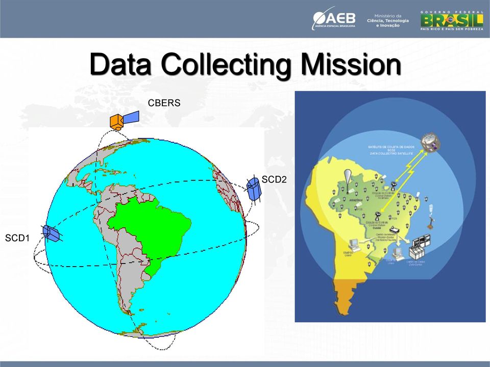


13 SCD 5 PLATAFORMAS DE COLETA DE DADOS - SISTEMA SCD - DEZ/ HIDROLÓGICA 262 METEOROLÓGICA 117 QUALIDADE D'ÁGUA

14

15


16 China Brazil Earth Resource Satellites CBERS

17 CBERS 1 October, 1999 CBERS 2 October, 2003 CBERS-2B September, 2007

18 CBERS-1 and 2 characteristics Total mass 1540 kg 80 kg hydrazine Mechanical structure 1.8x2.0x2.2 m aluminum and carbon fiber Electrical power 1100 W 14 m 2 silicon solar panel two 30 Ah NiCd batteries Propulsion system hydrazine 16 thrusters (1 N) 2 thrusters (20 N) Pointing accuracy 0.2 degree reaction wheels, magnetotorquers, gyros and sensors On-board data handling distributed 10 micro-processors Telemetry and command UHF and S-band ESA standard for S-Band Reliability 0.6 Aftter 2 year lifetime

19 Angra dos Reis and Ilha Grande in the Southern coast of RJ (IRMSS)

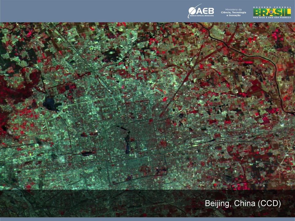
20 Beijing, China (CCD)
21 Northern China (CCD)
22 CBERS 3 and 4 Main Characteristics Mass Dimensions: Body Solar Array Electrical Power Payload Bit Rate Lifetime 1980 kg 1.8 x 2.3 x 3.2m 2.6 x 6.4m 2300 W 303 Mbits/sec 3 years
23 CBERS-3 and 4 Payloads Payload Geometric Resolution Spectral Bands Swath Width Revisit PAN Camera 5 m 10 m PAN G, R, NIR 60 km, lateral view 32 o 52 days MUX Camera 20 m B, G, R, NIR 120 km 26 days IRS Camera 40 m 80 m PAN, SW, MIR TIR 120 km 26 days WFI Camera DCS SEM 73 m B, G, R, NIR 866 km 5 days Data Collecting Subsystem Space Environment Monitor
24 China-Brazil Subsystem Work Share China TCS - Thermal Control AOCS - Attitude Control * OBDH - Onboard Data Handling * SCS - System Circuitry PAN camera (5m) IRS camera (40m) SEM Space Environment PIT Data Transmitter Structure Brazil EPSS - Electrical Power Supply TTCS Service Telecommunications MUX camera (20m) WFI-2 camera (73m) DDR Data Recorder DCS Data Collecting MWT Data Transmitter * AOCC, CTU and RTU are part of the Brazilian share
25 WFI/MUX
26 Structural Model Static Tests

27 The Multi-Mission Platform (PMM) & Applications
28 PMM pictorial view
29 ACDH: Pointing: < 0.05 o (3σ) Stability (Drift): < o /s Attitude determination: < o (3σ) Jitter < o Agility: 30 o in 180 s Payload: Mass: Volume: Power: Orbit: up to 280 kg ~1x1x1m 225 W average 900 W peak near-equatorial & polar 600 to 1200 km altitude
30
31
32 Amazônia 1 First satellite with PMM Optical payload PMM flight demonstration Amazon monitoring / deforestation
33 Spectral Bands (μm) AWFI B G R NIR Resolution (m) 40 Swath width (km) 700 Revisit (days) 5 Global coverage every two days together with CBERS-3
34 Scientific satellite Equars Mirax
35 Equars - Equatorial Atmosphere Research Satellite Temperature variation on the stratosphere and mesosphere Interplanetary gravity waves propagation Ionospheric plasma bubbles and irregularities Troposphere water vapor content Geocentric pointing
36 Mirax Monitor e Imageador de Raios X Observation of X-ray sources of the Galactic Center Spectroscopy in a wide band (2-200 kev) Inertial pointing / Galactic Center
37 Launchers Sounding rockets
38 Access to Space Sounding Rockets
39 Launchers VLS km VLS-1B km
40 Facilities Support for Satellite Development and Operations Ground Control Center
41 Facilities Support for Satellite Development and Operations Integration and Test Lab - LIT
42 Facilities Support to Satellite Development and Operations Propulsion and Combustion Lab
43 Facilities Support for Launch Vehicles Development and Operations Alcantara Launch Complex

44 Alcântara Alcantara Launch Center
45 ACS Alcantara Cyclone Space Brazil-Ukraine company CYCLONE-4
46 Earlier initiatives for low-cost and technological satellites in Brazil Dove (Digital Orbiting Voice Encoder) AMSAT-Br SACI s (Satélites de Aplicações Científicas) - INPE Dove-OSCAR 17 22/01/90 SACI-1 15/10/99 SACI-2 11/12/99
47 Itasat 1 Payloads: Digital data collection transceiver (CRN/INPE-UFRN) In orbit test of aluminum-acetone heat pipe (INPE-SJC) MEMS gyro experiment for attitude determination (UEL) Formation Flying Experiment: a leader-follower formation with Itasat 1 and a TU Berlin satellite From :Timm, C.: Diplomarbeit, TU Berlin, 2011
48 We will have in-house options VLM VLS Cyclone - 4
CBERS Program Update Jacie 2011. Frederico dos Santos Liporace AMS Kepler liporace@amskepler.com
 CBERS Program Update Jacie 2011 Frederico dos Santos Liporace AMS Kepler liporace@amskepler.com Overview CBERS 3 and 4 characteristics Differences from previous CBERS satellites (CBERS 1/2/2B) Geometric
National Program of Space Activities PNAE 2005-2014
 National Program of Space Activities PNAE 2005-2014 Brasília, DF 2005 President of the Republic Luiz Inácio Lula da Silva Minister of Science and Technology Eduardo Campos President of the Brazilian Space
FLIGHT DYNAMICS OPERATIONS OF INPE S SATELLITE CONTROL CENTER
 3 FLIGHT DYNAMICS OPERATIONS OF INPE S SATELLITE CONTROL CENTER VALCIR ORLANDO * HÉLIO KOITI KUGA INPE - Instituto Nacional de Pesquisas Espaciais CP 515 - São José dos Campos, SP 12201-970 Brazil * E-Mail:
Dr. Celal Sami Tüfekci & Erdem Demircioğlu Turksat AS
 Dr. Celal Sami Tüfekci & Erdem Demircioğlu Turksat AS 10 September 2008 Prague, Czech Republic Agenda Short company introduction Turksat s satellite design and R&D goals Outline Turksat s satellite design
RS platforms. Fabio Dell Acqua - Gruppo di Telerilevamento
 RS platforms Platform vs. instrument Sensor Platform Instrument The remote sensor can be ideally represented as an instrument carried by a platform Platforms Remote Sensing: Ground-based air-borne space-borne
SAC-C MISSION 2.0 CONAE INSTRUMENTS DESCRIPTION 2.1 MMRS
 SAC-C MISSION Carlos Alonso Carlos Hofmann SAC-C Program Manager SAC-C System Engineer CONAE (Comisión Nacional de Actividades Espaciales), Paseo Colón 751 (1063) Buenos Aires Argentina 1 Abstract. SAC-C
Quest- 1 Satellite Functional Description
 Quest- 1 Satellite Functional Description Overview The Quest- 1 Satellite is based on the CubeSat Standard that measures 10 cm x 10 cm x 10 cm and weighs less than 1.33 kilograms. The Quest- 1 Satellite
CSSAR Space Science Cooperation
 CSSAR Space Science Cooperation WANG Shuzhi Center for Space Science and Applied Research Chinese Academy of Science(CSSAR) Table of Contents Brief History of CSSAR International Cooperation CAS Strategic
Precision on earth. Reliability in space. RUAG Space.
 Precision on earth. Reliability in space. RUAG Space. Image: ESA Precision on earth. Reliability in space. RUAG Space is the leading supplier of products for the space industry in Europe. Experience, outstanding
ShindaiSat : A Visible Light Communication Experimental Micro-Satellite
 ShindaiSat : A Visible Light Communication Experimental Micro-Satellite Atsushi Nakajima, Nobutada Sako, Masato Kamemura, Yuuki Wakayama, Arata Fukuzawa, Hironori Sugiyama and Naoki Okada Graduate School
VIETNAM ACADEMY OF SCIENCE AND TECHNOLOGY VIETNAM NATIONAL SATELLITE CENTER CUBESAT PICO DRAGON. Presenter Name: Do Xuan Phong
 VIETNAM ACADEMY OF SCIENCE AND TECHNOLOGY VIETNAM NATIONAL SATELLITE CENTER CUBESAT PICO DRAGON Presenter Name: Do Xuan Phong Co-authors: Vu Viet Phuong, Truong Xuan Hung, Le Xuan Huy, Bui Nam Duong, Do
Satellite technology
 Satellite technology Overview What is a satellite? The key elements of orbital position Satellite manufacturers and design The components of a satellite: payload and bus Digital versus analogue How do
imaging satellite mission: eyeon
 EYEON GMBH Proposal for a highresolution multi-temporal imaging satellite mission: eyeon ESPACE Satellite Mission Design Project Meltem Eren, Fathalrahman Adam, Sean Hannon, Denise Schmidt, Nico Trebbin
Examination Space Missions and Applications I (AE2103) Faculty of Aerospace Engineering Delft University of Technology SAMPLE EXAM
 Faculty of Aerospace Engineering Delft University of Technology SAMPLE EXAM") Examination Space Missions and Applications I AE2103 Faculty of Aerospace Engineering Delft University of Technology SAMPLE EXAM Please read these instructions first: This are a series of multiple-choice
Examination Space Missions and Applications I AE2103 Faculty of Aerospace Engineering Delft University of Technology SAMPLE EXAM Please read these instructions first: This are a series of multiple-choice
Nanosat 4 Competition
 Nanosat 4 Competition NMSUSat2 Team New Mexico State University College of Engineering Presented by Jeremy Bruggemann Topics Competition Overview Mission Overview Design Concept Tests and Analyses Hardware
R1 The meeting endorses the recommendations from the ATMOS User Meeting in 2012. All of which are relevant
 R1 The meeting endorses the recommendations from the ATMOS User Meeting in 2012. All of which are relevant We recognize that some projects have been initiated to address some of the deficits in 2012. However
Overview of NASA s Laser Communications Relay Demonstration
 Overview of NASA s Laser Communications Relay Demonstration April 2012 Bernard Edwards NASA Goddard Space Flight Center (301) 286-8926 Bernard.L.Edwards@nasa.gov 1 LCRD Demonstration Scenarios Mission
The National Strategy, Current Activities for Space Technology Development and Application
 14-18 November 2011, Putrajaya, Malaysia The National Strategy, Current Activities for Space Technology Development and Application Lai Anh Khoi Space Technology Institute, VAST, Vietnam Bief History Space
DSL Mission Concept at Lunar Orbit
 DSL Mission Concept at Lunar Orbit Jingye Yan Na9onal Space Science Center (NSSC) Chinese Academy of Sciences (CAS) 2015-02- 02, ASTRON, The Netherland 1 Payload onboard single nano- sat Element antenna
16 th IOCCG Committee annual meeting. Plymouth, UK 15 17 February 2011. mission: Present status and near future
 16 th IOCCG Committee annual meeting Plymouth, UK 15 17 February 2011 The Meteor 3M Mt satellite mission: Present status and near future plans MISSION AIMS Satellites of the series METEOR M M are purposed
OUTLINES. Earth Observation Satellite Program of Vietnam and applications for disaster management
 UNESCAP ICC & HLDM Meetings, Bangkok 26 28/11/2013 Earth Observation Satellite Program of Vietnam and applications for disaster management OUTLINES 1. VNREDSat-1 (VAST*) - Optical 2. VNREDSat-1B (VAST)
Description of the AAU satellite Project. CubeSat Concept. Financing. Organization
 Projects Catalogue for AAU satellite /DRAFT by Rafael Wisniewski (I8), Ole Thybo (15), Stig Munk Nielsen (I14), Brian Nielsen (I16), Thomas Bak (I8), Lasse Rosendahl (I14) Description of the AAU satellite
A First-MOVE in satellite development at the TUM
 A First-MOVE in satellite development at the TUM Manuel Czech 7th IAA Symposium on Small Satellites for Earth Observation Berlin, 05.05.2009 The Munich Orbital Verification Experiment MOVE Summary MOVE
Space Export Controls Update
 Space Export Controls Update Since Delivering the 1248 Report to Congress - April 2012 Congress added language into the FY13 National Defense Authorization Act that gave the President the authority to
National Institute for Space Research (INPE) Earth Science System Center (CCST)
 Earth Science System Center (CCST)") National Institute for Space Research (INPE) Earth Science System Center (CCST) Lincoln Muniz Alves lincoln.alves@inpe.br Acknowledgment: Ana Paula Aguiar, Milton Kampel, Simone Costa, Nelson Ferreira,
National Institute for Space Research (INPE) Earth Science System Center (CCST) Lincoln Muniz Alves lincoln.alves@inpe.br Acknowledgment: Ana Paula Aguiar, Milton Kampel, Simone Costa, Nelson Ferreira,
Laser Ranging to Nano-Satellites
 13-0222 Laser Ranging to Nano-Satellites G. Kirchner (1), Ludwig Grunwaldt (2), Reinhard Neubert (2), Franz Koidl (1), Merlin Barschke (3), Zizung Yoon (3), Hauke Fiedler (4), Christine Hollenstein (5)
SpaceLoft XL Sub-Orbital Launch Vehicle
 SpaceLoft XL Sub-Orbital Launch Vehicle The SpaceLoft XL is UP Aerospace s workhorse space launch vehicle -- ideal for significant-size payloads and multiple, simultaneous-customer operations. SpaceLoft
Yukikatsu Terada (Saitama Univ, Japan), on behalf of the Astro-H Software Calibration board
, on behalf of the Astro-H Software Calibration board") Yukikatsu Terada (Saitama Univ, Japan), on behalf of the Astro-H Software Calibration board SKIP (Rob Introduction) The sixth series of the Japanese X-ray satellite. Collaboration with JAXA, NASA, and
Yukikatsu Terada (Saitama Univ, Japan), on behalf of the Astro-H Software Calibration board SKIP (Rob Introduction) The sixth series of the Japanese X-ray satellite. Collaboration with JAXA, NASA, and
'l'ehisat. A IfICROSATBLLI'l'E SYS'l'EH FOR AlJ'rONOHOUS ENVIRONIfElI'.rAL IfONI'l'ORING SERVICR
 'l'ehsat A fcrosatbll'l'e SYS'l'EH FOR AlJ'rONOHOUS ENVRONfEl'.rAL fon'l'orng SERVCR Brunella Paves! (1), Giuseppe Rondinelli (1) Nikolaos Balteas (2) (1) f!lesp1zo S.p.a. - Via 'l'iburtlna 965-00156 ROJa,
Visualizing Wireless Transfer of Power: Proposal for A Five-Nation Demonstration by 2020. ISDC2012: Washington DC, May 26, 2012
 Visualizing Wireless Transfer of Power: Proposal for A Five-Nation Demonstration by 2020 Don Flournoy Ohio University Brendan Dessanti & Narayanan Komerath Georgia Institute of Technology ISDC2012: Washington
China Earth Observation
 China High-resolution Earth Observation China Earth Observation System (CHEOS) and its Lastest Development The Earth Observation System and Data Center, CNSA 2014-2 Outlines 1 Introduction 2 The composition
Department of Aeronautics and Astronautics School of Engineering Massachusetts Institute of Technology. Graduate Program (S.M., Ph.D., Sc.D.
 Department of Aeronautics and Astronautics School of Engineering Massachusetts Institute of Technology Graduate Program (S.M., Ph.D., Sc.D.) Field: Space Propulsion Date: October 15, 2013 1. Introduction
BRAZILIAN CONTRIBUTION TO THE LISN PROJECT
 BRAZILIAN CONTRIBUTION TO THE LISN PROJECT (LOW-LATITUDE IONOSPHERIC SENSOR NETWORK) I. J. Kantor, E.R de Paula, L.F.C. de Rezende, M.T.H. Muella and A.C. Neto INPE, Aeronomy Division, São José dos Campos,
Mars Sample Return Campaign: An Overview. Dr. Firouz Naderi Associate Director NASA s JPL
 Mars Sample Return Campaign: An Overview Dr. Firouz Naderi Associate Director NASA s JPL 1 Why Sample Return? Why Now? Compelling Science Informed Landing Site Selection International Interest Good Engineering
A Fractionated Space Weather Base at L 5 using CubeSats & Solar Sails
 A Fractionated Space Weather Base at L 5 using CubeSats & Solar Sails Paulett C. Liewer, Andrew T. Klesh, Martin W. Lo, Neil Murphy, Robert L. Staehle, Vassilis Angelopoulos, Jet Propulsion Laboratory,
UAV Road Surface Monitoring and Traffic Information
 UAV Road Surface Monitoring and Traffic Information Czech Road and Motorway Network New capabilities for Unmanned Aerial Systems Current usage (military operation service) Possible civil usage (possible
TerraAmazon - The Amazon Deforestation Monitoring System - Karine Reis Ferreira
 TerraAmazon - The Amazon Deforestation Monitoring System - Karine Reis Ferreira GEOSS Users & Architecture Workshop XXIV: Water Security & Governance - Accra Ghana / October 2008 INPE National Institute
C-S TEAM. Page 1 of 5
 Title: Medium/large vehicle tracking system Primary POC: Jacoba Auret Organization: C-S Team (Cape Peninsula University of Technology-Stellenbosch University) POC email: 14807599@sun.ac.za Need We exist
INTA AIRBORNE REMOTE SENSING FACILITY from the Hasselblad s cameras to the SensyTech-AHS sensor
 INTA AIRBORNE REMOTE SENSING FACILITY from the Hasselblad s cameras to the SensyTech-AHS sensor José-Antonio Gómez-Sánchez gomezsj@inta.es Remote Sensing Laboratory INSTITUTO NACIONAL DE TÉCNICA AEROESPACIAL
CHUVA. by CHUVA Science Team. 4 th CHUVA Planning Meeting 13 December 2010 San Francisco, CA. Rachel I. Albrecht rachel.albrecht@cptec.inpe.
 CHUVA Cloud processes of the main precipitation systems in Brazil: A contribution to cloud resolving modeling and to the GPM (GlobAl Precipitation Measurement) by CHUVA Science Team Rachel I. Albrecht
Fernando Aguado-Agelet University of Vigo - INTA
 Fernando Aguado-Agelet University of Vigo - INTA August 10th 2008 2008 Cubesat Summer Developer s Workshop 1 Project Presentation GENERAL DESCRIPTION University of Vigo: Leader Spanish university in R+D
Introduction to teledection
 Introduction to teledection Formation Sébastien Clerc, ACRI-ST sebastien.clerc@acri-st.fr ACRI-ST Earth Observation Actors and Markets 2 Earth Observation economic importance Earth Observation is one of
Hyperspectral Satellite Imaging Planning a Mission
 Hyperspectral Satellite Imaging Planning a Mission Victor Gardner University of Maryland 2007 AIAA Region 1 Mid-Atlantic Student Conference National Institute of Aerospace, Langley, VA Outline Objective
Studies on the ionospheric region during low solar activity in Brazil
 Studies on the ionospheric region during low solar activity in Brazil Claudia M. N. Candido National Institute for Space Research - INPE Brazil 1 Plasma Bubbles-Spread-F OI 630.0-nm Peak at 250 km - F-layer
PETROBRAS Orbital Sea Surface Monitoring
 PETROBRAS Orbital Sea Surface Monitoring Performed by : Contingency Control - Exploration & Production Area Technical support: R&D Center Cristina Bentz PETROBRAS R&D Center Environment Assessment and
Overview of the Orbiting Carbon Observatory (OCO) Mishap Investigation Results For Public Release
 Mishap Investigation Results For Public Release") Overview of the Orbiting Carbon Observatory (OCO) Mishap Investigation Results For Public Release SUMMARY The Orbiting Carbon Observatory was a National Aeronautics and Space Administration satellite mission
Overview of the Orbiting Carbon Observatory (OCO) Mishap Investigation Results For Public Release SUMMARY The Orbiting Carbon Observatory was a National Aeronautics and Space Administration satellite mission
Introduction of Small Solar Power Sail Demonstrator IKAROS
 Introduction of Small Solar Power Sail Demonstrator IKAROS IKAROS Demonstration Team JAXA Space Exploration Center (JSPEC) Japan Aerospace Exploration Agency (JAXA) Overview of IKAROS IKAROS is a space
University microsatellites: an hands-on educational tool
 University microsatellites: an hands-on educational tool Massimiliano RONZITTI School of Aerospace Engineering Università degli Studi di Roma La Sapienza December 2006 The content of this presentation
Referências Bibliográficas
 Referências Bibliográficas Abdu, M. A.; Sobral, J. H. A.; Nelson, O. R.; Batista, I. S. Solar cycle related range type spread-f occurrence characteristics over equatorial and low latitude stations in Brazil.
Pre-4th Mission Idea Contest, 3 rd UNISEC Global Meeting 4 July 2015, Takeda Hall, Asano Campus University of Tokyo, Japan
 Pre-4th Mission Idea Contest, 3 rd UNISEC Global Meeting 4 July 2015, Takeda Hall, Asano Campus University of Tokyo, Japan Presented by BENDOUKHA, SIDI AHMED DURAN, ADELAIDA CASTILLO 1 Outline of the Presentation:
Integration and Testing The MESSENGER Mission to Mercury
 Integration and Testing The MESSENGER Mission to Mercury Marcelite Jenkins Kenneth Brown South Carolina State University 1 MErcury Surface, Space ENviroment, GEochemistry, and Ranging 2 Why Mercury? Mercury
7th Agile Meeting & The Bright Gamma-Ray Sky Frascati, 29 September - 1 October, 2009. Carlotta Pittori, on behalf of the ADC
 7th Agile Meeting & The Bright Gamma-Ray Sky Frascati, 29 September - 1 October, 2009 The AGILE Data Center and the First AGILE Catalog Carlotta Pittori, on behalf of the ADC AGILE GS Architecture Fucino,
The Elwing Company THE ELWING COMPANY. EPIC Workshop 2014. Products and Systems 2015 2020
 The Elwing Company THE ELWING COMPANY EPIC Workshop 2014 Products and Systems 2015 2020 Elwing E IMPAcT technology key features Erosion free Contamination free Short circuit free Multiple modes Thurst/
Congresso della SAIT Museo della Scienza e della Tecnologia di Milano 15 Maggio 2014
 Congresso della SAIT Museo della Scienza e della Tecnologia di Milano 15 Maggio 2014 Francesca Esposito INAF Osservatorio Astronomico di Capodimonte (Napoli) ExoMars Mission The ExoMars Program is carried
DEOS. Deutsche Orbitale Servicing Mission. The In-flight Technology Demonstration of Germany s Robotics Approach to Service Satellites
 DEOS Deutsche Orbitale Servicing Mission The In-flight Technology Demonstration of Germany s Robotics Approach to Service Satellites B. Sommer, K. Landzettel, T. Wolf, D. Reintsema, German Aerospace Center
Both wireless links can be obviously replaced by wired links if preferred by the mission/application.
 Fully Steerable Wireless Micro-Camera The product is a COTS (Commercial Off-The-Shelf) micro-camera working in visible field with possible adaptation in the infrared. The data transmission versus a remote
Satellite Communications
 Satellite Communications Department of Electrical Engineering Faculty of Engineering Chiangmai University Origin of Satellite Communications Arthur C. Clark (1945) British Science fiction writer propose
Overview of the Canadian Electric Field Instrument (CEFI) for Swarm
 for Swarm") Overview of the Canadian Electric Field Instrument (CEFI) for Swarm Brian Moffat (a), John Hackett (a), David Knudsen (b), Jan-Erik Wahlund (c), Lennart Åhlén (c), Nico Stricker (d) (a) COM DEV Ltd., Cambridge
Overview of the Canadian Electric Field Instrument (CEFI) for Swarm Brian Moffat (a), John Hackett (a), David Knudsen (b), Jan-Erik Wahlund (c), Lennart Åhlén (c), Nico Stricker (d) (a) COM DEV Ltd., Cambridge
MATS Mission Definition Phase Report
 MATS Mission Definition Phase Report Public Summary 2014-10-20 Lead authors: J. Gumbel 1, N. Ahlgren 2, N. Larsson 2, F. v. Schéele 3 1 Department of Meteorology Stockholm University 106 91 Stockholm Sweden
CHAPTER 2 ORBITAL DYNAMICS
 14 CHAPTER 2 ORBITAL DYNAMICS 2.1 INTRODUCTION This chapter presents definitions of coordinate systems that are used in the satellite, brief description about satellite equations of motion and relative
Technologies for Re-entry Vehicles. SHEFEX and REX FreeFlyer, DLR s Re-Entry Program. Hendrik Weihs. Folie 1. Vortrag > Autor > Dokumentname > Datum
 Technologies for Re-entry Vehicles SHEFEX and REX FreeFlyer, DLR s Re-Entry Program Hendrik Weihs Folie 1 DLR`s Re-Entry Program, Why? Re-entry or return technology respectively, is a strategic key competence
The Sentinel-4/UVN instrument on-board MTG-S
 The Sentinel-4/UVN instrument on-board MTG-S Grégory Bazalgette Courrèges-Lacoste; Berit Ahlers; Benedikt Guldimann; Alex Short; Ben Veihelmann, Hendrik Stark ESA ESTEC European Space Technology & Research
MODELLING A SATELLITE CONTROL SYSTEM SIMULATOR
 National nstitute for Space Research NPE Space Mechanics and Control Division DMC São José dos Campos, SP, Brasil MODELLNG A SATELLTE CONTROL SYSTEM SMULATOR Luiz C Gadelha Souza gadelha@dem.inpe.br rd
The IRIS Project: A new architecture for a small satellite imaging mission.
 The IRIS Project: A new architecture for a small satellite imaging mission. Quinn Young Space Dynamics Laboratory, Utah State University Research Foundation 1695 North Research Park Way, North Logan, UT
Remote Level Monitoring Unit
 Remote Level Monitoring Unit SPECIFICATIONS LASER MEASUREMENT Type InGasAs Laser Diode Wavelength 905 nm Beam Divergence 2.3 x 0.2 mrad (typical) Passive Range 0.5m to 150m Range to Reflective Target 0.5m
High Resolution Information from Seven Years of ASTER Data
 High Resolution Information from Seven Years of ASTER Data Anna Colvin Michigan Technological University Department of Geological and Mining Engineering and Sciences Outline Part I ASTER mission Terra
From Single to Formation Flying CubeSats: An Update of the Delfi Programme
 From Single to Formation Flying CubeSats: An Update of the Delfi Programme Jian Guo, Jasper Bouwmeester & Eberhard Gill 1 Outline Introduction Delfi-C 3 Mission Delfi-n3Xt Mission Lessons Learned DelFFi
IV WORKSHOP RNP2 (WRNP2)
") IV WORKSHOP RNP2 (WRNP2) Hotel Pirâmide, Natal, RN, 19-20 de Maio de 2003 Advanced Network Engineering and Applications from Space Missions - AUTHORS - Eduardo W. Bergamini Serviços Aplicativos em Missões
IV WORKSHOP RNP2 (WRNP2) Hotel Pirâmide, Natal, RN, 19-20 de Maio de 2003 Advanced Network Engineering and Applications from Space Missions - AUTHORS - Eduardo W. Bergamini Serviços Aplicativos em Missões
Robotic Pre-Cursor Contribution to Human NEA Mission. H. Kuninaka JSPEC/JAXA
 Robotic Pre-Cursor Contribution to Human NEA Mission H. Kuninaka JSPEC/JAXA Asteroid Explorer Hayabusa Dimensions 1.0m x 1.6m x 1.1m Weight : 380kg(Dry) Chemical Fuel 70kg Xe Propellant 60kg Total 510kg
"Spazio. e Radioamatori " AMSAT Italia e C.I.S.A.R. Per il convegno. SpaceLab. organizzato da. Roma, 2 Dicembre 2006
 Per il convegno "Spazio e Radioamatori " organizzato da AMSAT Italia e C.I.S.A.R. Roma, 2 Dicembre 2006 The Institute Scuola Universitaria Professionale A practice-oriented, innovation-devoted higher education
INPE Spatial Data Infrastructure for Big Spatiotemporal Data Sets. Karine Reis Ferreira (INPE-Brazil)
") INPE Spatial Data Infrastructure for Big Spatiotemporal Data Sets Karine Reis Ferreira (INPE-Brazil) INPE (Brazil) and Big Data I work at INPE (Brazilian National Institute for Space Research). Main gate
INPE Spatial Data Infrastructure for Big Spatiotemporal Data Sets Karine Reis Ferreira (INPE-Brazil) INPE (Brazil) and Big Data I work at INPE (Brazilian National Institute for Space Research). Main gate
Graduate Certificate Program in Energy Conversion & Transport Offered by the Department of Mechanical and Aerospace Engineering
 Graduate Certificate Program in Energy Conversion & Transport Offered by the Department of Mechanical and Aerospace Engineering Intended Audience: Main Campus Students Distance (online students) Both Purpose:
How Long Do You Need To Achieve Your Scientific Objectives?
 How Long Do You Need To Achieve Your Scientific Objectives? Time seconds minutes days/weeks months Drop Towers/Drop Tubes KC-135 Parabolic Flights Balloons* Sounding Rockets Alternate Carriers* Shuttle
LANDSAT 7 - GROUND SEGMENT ACTIVITIES AT THE GERMAN REMOTE SENSING DATA CENTER. Deutsches Fernerkundungsdatenzentrum (DFD) DLR (*)
 DLR (*)") LANDSAT 7 - GROUND SEGMENT ACTIVITIES AT THE GERMAN REMOTE SENSING DATA CENTER Günter Strunz (*), Hans-Dietrich Bettac (**), Jörg Gredel (*), Klaus-Dieter Reiniger (*) & Gunter Schreier (*) Deutsches Fernerkundungsdatenzentrum
LANDSAT 7 - GROUND SEGMENT ACTIVITIES AT THE GERMAN REMOTE SENSING DATA CENTER Günter Strunz (*), Hans-Dietrich Bettac (**), Jörg Gredel (*), Klaus-Dieter Reiniger (*) & Gunter Schreier (*) Deutsches Fernerkundungsdatenzentrum
The RapidEye optical satellite family for high resolution imagery
 'Photogrammetric Week 01' D. Fritsch & R. Spiller, Eds. Wichmann Verlag, Heidelberg 2001. Scherer, Krischke 139 The RapidEye optical satellite family for high resolution imagery STEFAN SCHERER and MANFRED
Space Environment and Satellite Systems: Removing Clutter from Ground-to-Satellite Signals. Sigrid Close
 Space Environment and Satellite Systems: Removing Clutter from Ground-to-Satellite Signals Sigrid Close Background Overview RF propagation through ionosphere can be problematic Goals Traditionally too
APPLICATION OF TERRA/ASTER DATA ON AGRICULTURE LAND MAPPING. Genya SAITO*, Naoki ISHITSUKA*, Yoneharu MATANO**, and Masatane KATO***
 APPLICATION OF TERRA/ASTER DATA ON AGRICULTURE LAND MAPPING Genya SAITO*, Naoki ISHITSUKA*, Yoneharu MATANO**, and Masatane KATO*** *National Institute for Agro-Environmental Sciences 3-1-3 Kannondai Tsukuba
THE GOCI INSTRUMENT ON COMS MISSION THE FIRST GEOSTATIONARY OCEAN COLOR IMAGER
 THE GOCI INSTRUMENT ON COMS MISSION THE FIRST GEOSTATIONARY OCEAN COLOR IMAGER Topic 1 - Optical instruments for Earth / Planets surface and atmosphere study François FAURE, Astrium SAS Satellite, Toulouse,
IV. Rocket Propulsion Systems. A. Overview
 IV. Rocket Propulsion Systems A. Overview by J. M. Seitzman for AE 4451 Jet and Rocket Propulsion Seitzman Rocket Overview-1 Rocket Definition Rocket Device that provides thrust to a vehicle by accelerating
ERS and ENVISAT missions status
 FRINGE 2005 Workshop ERS and ENVISAT missions status Wolfgang Lengert ERS Mission Manager ERS-2 mission 14 years of ERS-1/2 data in the archive (suitable for applications requiring long term series products)
Spacecraft Power Systems
 Spacecraft Power Systems AOE 4065 Space Design Refs: SMAD Chap 11.4, G&F Chap 10, F&S Chap 11, P&M Chap 6 Electrical Power Subsystem (EPS) Functions Supply electrical power to spacecraft loads Control
TIMED Mission System Engineering and System Architecture
 TIMED Mission System Engineering and System Architecture David Y. Kusnierkiewicz Aspace mission consists of more than just a spacecraft and scientific instruments. It also includes a ground system to support
UK Global Forest Monitoring Network: Forest Carbon Tracking
 UK Global Forest Monitoring Network: Forest Carbon Tracking Andy Shaw Director, Knowledge Exchange, NCEO Head of Strategic Business Development, ISIC GMES/GEO Forum, ISIC, 2011 What is happening to the
June VV 05. Sentinel-2A LOGOTYPE COMPLET (SYMBOLE ET TYPOGRAPHIE) 294C
 294C") LOGOTYPE TONS MONOCHROME 294C June 2015 VV 05 LOGOTYPE COMPLET (SYMBOLE ET TYPOGRAPHIE) FIFTH VEGA LAUNCH FROM THE GUIANA SPACE CENTER, AT THE SERVICE OF EUROPE'S COPERNICUS PROGRAM On the fifth Vega mission
LOGOTYPE TONS MONOCHROME 294C June 2015 VV 05 LOGOTYPE COMPLET (SYMBOLE ET TYPOGRAPHIE) FIFTH VEGA LAUNCH FROM THE GUIANA SPACE CENTER, AT THE SERVICE OF EUROPE'S COPERNICUS PROGRAM On the fifth Vega mission
United Nations - Nations Unies. COSPAR Symposium. Measuring the Universe. Looking Back in Time with Modern Astronomy. Monday, 2nd February 2015
 United Nations - Nations Unies COSPAR Symposium Measuring the Universe Looking Back in Time with Modern Astronomy Monday, 2nd February 2015 15:00 18:00 Conference Rooms M1, Building M, Vienna International
German Antarctic Receiving Station GARS O Higgins: Remote sensing as core for a broader range of activities
 DLR.de Chart 1 > Kathrin Hoeppner > EU-Chile-Workshop > November 28-29, 2013 > Punta Arenas, Chile German Antarctic Receiving Station GARS O Higgins: Remote sensing as core for a broader range of activities
SATELLITE VULNERABILITY TO SPACE DEBRIS RISK
 SIXTH IASS CONFERENCE Montreal 21 23 May 2013 Denis Bensoussan Senior Underwriter Space Risks SATELLITE VULNERABILITY TO SPACE DEBRIS RISK Space debris risks assessment Satellites potential casualty of
EyasSAT: A Classroom Nanosatellite for Teaching Space Systems Engineering. EyasSAT 1
 : A Classroom Nanosatellite for Teaching Space Systems Engineering 1 Introduction The Need The Solution Background System Architecture Applications Conclusions Outline 2 The Need Space Systems Engineering
Laguduva Kubendran, PhD, MBA Program Executive, NASA HQ GSFC Emerging Commercial Suborbital Capabilities Workshop September 7, 2011. www.nasa.
 Laguduva Kubendran, PhD, MBA Program Executive, NASA HQ GSFC Emerging Commercial Suborbital Capabilities Workshop September 7, 2011 www.nasa.gov Office of the Chief Technologist Program Map Space Tech
Multiangle cloud remote sensing from
 Multiangle cloud remote sensing from POLDER3/PARASOL Cloud phase, optical thickness and albedo F. Parol, J. Riedi, S. Zeng, C. Vanbauce, N. Ferlay, F. Thieuleux, L.C. Labonnote and C. Cornet Laboratoire
NASA s Dawn Mission Journey to the Asteroid Frontier
 NASA s Dawn Mission Journey to the Asteroid Frontier Dawn Lucy McFadden, Co-Investigator University of Maryland College Park, MD January 12, 2009 SBAG update 9 th Discovery Mission Dawn Explores the Earliest
Space Weather Research and Forecasting in CRL, Japan
 Space Weather Research and Forecasting in CRL, Japan Maki Akioka Hiraiso Solar Observatory Communications Research Laboratory Contact akioka@crl.go.jp 1 Contents of Presentation 1.Space Weather Observation
Can Hubble be Moved to the International Space Station? 1
 Can Hubble be Moved to the International Space Station? 1 On January 16, NASA Administrator Sean O Keefe informed scientists and engineers at the Goddard Space Flight Center (GSFC) that plans to service
CONSTRUCTING A CONSTELLATION OF 6U SOLAR POWER CUBE SATELLITES
 CONSTRUCTING A CONSTELLATION OF 6U SOLAR POWER CUBE SATELLITES Authors: Corey Bergsrud 1, Jeremy Straub 2, Matthew Clausing 3, Johnathan McClure 1, and Sima Noghanian 1. 1 Department of Electrical Engineering,
2. Orbits. FER-Zagreb, Satellite communication systems 2011/12
 2. Orbits Topics Orbit types Kepler and Newton laws Coverage area Influence of Earth 1 Orbit types According to inclination angle Equatorial Polar Inclinational orbit According to shape Circular orbit
To Uranus on Solar Power and Batteries
 To Uranus on Solar Power and Batteries Mark Hofstadter Jet Propulsion Laboratory, California Institute of Technology Report to OPAG, 9 March 2009 Bethesda, Maryland Voyager 1986 Hubble 1998 (Karkoschka)
POWER GENERATION AND DISTRIBUTION SYSTEM DESIGN FOR THE LEONIDAS CUBESAT NETWORK
 POWER GENERATION AND DISTRIBUTION SYSTEM DESIGN FOR THE LEONIDAS CUBESAT NETWORK Justin M. Akagi Department of Electrical Engineering University of Hawai`i at Manoa Honolulu, HI 96822 ABSTRACT The Power
Chapter 2. Mission Analysis. 2.1 Mission Geometry
 Chapter 2 Mission Analysis As noted in Chapter 1, orbital and attitude dynamics must be considered as coupled. That is to say, the orbital motion of a spacecraft affects the attitude motion, and the attitude
LANDSAT 8 Level 1 Product Performance
 Réf: IDEAS-TN-10-QualityReport LANDSAT 8 Level 1 Product Performance Quality Report Month/Year: January 2016 Date: 26/01/2016 Issue/Rev:1/9 1. Scope of this document On May 30, 2013, data from the Landsat
Small Satellite Attitude Determination With RF Carrier Phase Measurement
 Politecnico di Torino Electronics Department IAC-09.C1.6.9 Small Satellite Attitude Determination With RF Carrier Phase Measurement Danilo Roascio, Leonardo M. Reyneri, Claudio Sansoé, Maurizio Bruno International