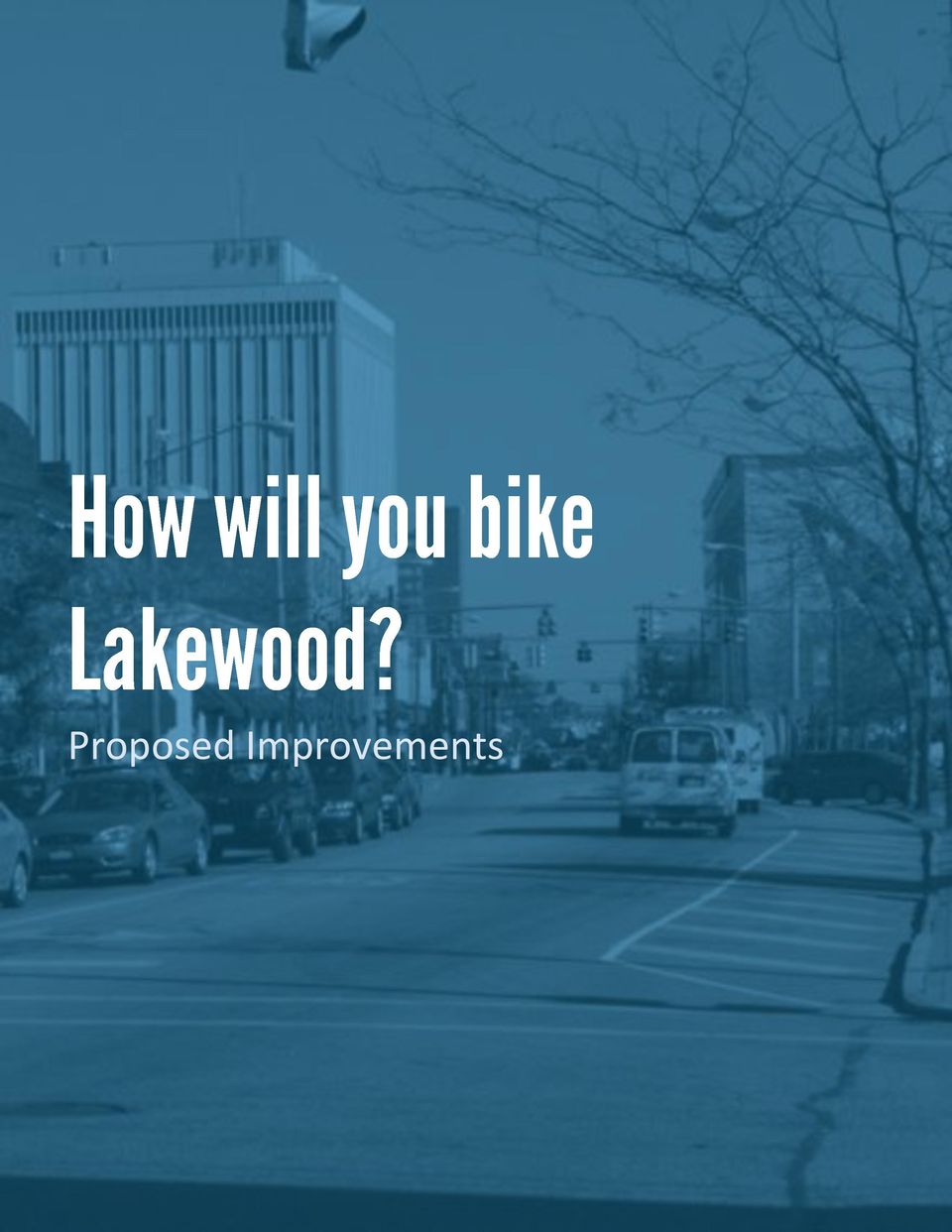
DRAFT. Bicycle Master Plan Adopted by Council: (TBD) DRAFT 1
|
|
|
- Myron Rose
- 8 years ago
- Views:
Transcription
")
1 DRAFT Bicycle Master Plan Adopted by Council: (TBD) DRAFT 1
")
2 Thank you to the hundreds of residents that contributed to the plan. They are the authors and the reason this plan exists. Plan Prepared by: The City of Lakewood Department of Planning & Development Detroit Avenue Lakewood, Ohio Michael P. Summers, Mayor Dru Siley, Director Nick Workman, Intern Planner Bryce Sylvester, Intern Planner Special Thanks to: City Council David W. Anderson (Ward 1) Thomas Bullock (Ward 2) Shawn Juris (Ward 3) Mary Louise Madigan (Ward 4) Ryan Nowlin (At-Large) Brian E. Powers (At-Large) Monique Smith (At-Large) Planning Commission Mary Cierebiej Thomas Einhouse Hannah Fritzman Belsito Ruth Anne Gillette Robert Greytak Tamara Karel Mark Stockman DRAFT 2
 Thomas Bullock (Ward 2) Shawn Juris (Ward 3) Mary Louise Madigan (Ward 4) Ryan Nowlin (At-Large) Brian E.")
3 Executive Summary 5 Process of the Plan Vision Statement & Goals Why is Bicycle Planning Important in Lakewood? Benefits of a Well Designed Bike Network Purpose of the Plan Rules on the Road: In Plain English What Do We Need? 8 Vision Statement & Goals Action Plan Where Are We Today? 10 The Nation At-a-Glance Ohio At-a-Glace Northeast Ohio At-a-Glance Lakewood At-a-Glance How Will You Bike Lakewood? 20 Expand Our Supply of Bike Racks Establish Our Primary Bikeway System: Share the Road Educate and Reach Out A Closer Look: Madison Avenue Reconfiguration Design Guidelines & Standards 28 Signage Parking Appendix 31 Works Cited Results from Lakewood Community Bike Survey Results from Bike and Walk to School Parent/Caregiver Survey Summary DRAFT 3


4 October 5, 2010 October 31, 2010 November 4, 2010 November 9, 2010 October 2010: Lakewood Community Bike Survey Posted Bicycle and Pedestrian Counts Undertaken October 2011 Community Workshop #1 Main Library Auditorium 6:30-8:00 PM Biking Community profile/survey Route and facility needs Input : Direct Observation & Study Period Existing Conditions and Needs Assessment Report Update to Planning Commission and Council City Hall Auditorium 7:00 PM Community Workshop #3 Location TBD October 26, 2011 December 2011 Community Workshop #2 Main Library Auditorium 6:30-8:00 PM Proposed Network Routes and facilities 2012 Bicycle Master Plan Implemented DRAFT 4

5 Vision Statement & Goals The vision of the Bicycle Master Plan is to establish bicycling as a main means of transportation and accommodate current bicyclists needs through policies, programs & projects. The City s goal is to be nationally recognized as one of the most bicycle friendly communities in the country by 2015 based on the standards set by the League of American Bicyclists (link). Bicycling promotes efficient land use, promotes efficient use of road space, promotes equitable transportation, supports buying local, promotes health and fitness, reduces air and noise pollution, reduces traffic congestion, reduces taxpayer burden, reduces parking demand, reduces energy use, and is an integral part of a progressive community. Why is Bicycle Planning Important in Lakewood? We have a significant bicycling population. Lakewood has a significant bicycling population of both transportation and recreational riders. According to the 2008 American Community Survey (ACS), Lakewood ranks #1 in Ohio for resident bike commuters in cities with less than 100,000 residents. For detailed information about our bike community, please refer to the bike survey in the Appendix. Benefits of a Well Designed Bike Network Improved Quality of Life Efficient and Sustainable Transportation Resident Attraction and Retention Public Health Equity Economic Development Purpose of the Plan In the interest of achieving our goal and improving the cycling environment, the bicycle plan s purpose is to identify and then direct the implementation of a continuous network of cross-town routes and facilities and to recommend improvement priorities, funding opportunities and necessary policies. Such a network will then allow safe and convenient bicycle travel throughout the community for riders of all abilities, skills and objectives. We have a built environment that encourages bicycling. Most of Lakewood is flat, densely-populated and was developed around streetcar lines, creating a compact layout that offers relatively short distances between schools, parks, residential areas and commercial centers. Most vehicle trips inside the City are less than five miles round trip and could be accomplished on a bicycle because of the city s layout. But we can get better. We can continue to improve the infrastructure that supports bicycling as a primary means of transportation in the city. Bikes parked at Garfield Elementary School DRAFT 5

, see below for the rules explained in plain English: If you are riding in the street you are granted all of the")
6 If you are interested in the formal bicycle traffic rules, please see the Codified Ordinances: Part 3, Title 9, Chapter 373. If you are not in the mood to investigate our Codified Ordinances (we don t blame you), see below for the rules explained in plain English: If you are riding in the street you are granted all of the same rights and assume all of the same duties as the driver of a vehicle. If riding on a roadway, no more than two people can ride alongside each other. If riding on a road, you must ride as near to the right side of the road as possible, following all traffic rules and carefully passing parked vehicles. It is legal to ride on the sidewalk if it is not congested. Your parked bike cannot block pedestrian or vehicular traffic. Your bike has to be licensed by the Police Department. DRAFT 6

7 The vision of the Bicycle Master Plan is to establish bicycling as a main means of transportation and accommodate current bicyclists needs through policies, programs & projects. Explain the existing cycling framework in Lakewood. Identify an action plan to improve safety and mobility for cyclists. Earn national recognition as one of the most bicycle friendly communities in the country by DRAFT 7


8 Bicycling is transportation. Image Source: Critical Mass Cleveland DRAFT 8

9 Objectives to Achieve Now Our plan addresses three actionable items to achieve now, that together will establish a comprehensive cycling network, because bicycling is transportation in Lakewood. Expand Our Supply of Bike Racks A bike rack implementation program provides employees, students, families, business patrons and all residents access to ample bike parking which will be inherently embedded within the city framework. Establish Our Primary Bikeway System: Share the Road A bikeway network will send a clear message to both bicyclists and motorists that road space is to be used by everyone. Educate and Reach Out Rinse, lather, and repeat. As the saying goes, we will educate, raise awareness, and continually remind residents that bicycling is transportation through directed programs and initiatives. DRAFT 9

10 Bicycling is alternative transportation. Image Source: Cleveland.com DRAFT 10

11 Spending (Millions) Figure 2.1 Federal Spending on Bicycle Facilities Travel by automobile is more expensive than ever before. Over a 5 year period, the price of gas has increased by 62% (Gas Buddy). According to the Bureau of Labor Statistics, car ownership costs are the second largest household expense in the nation. Americans are less healthy. The obesity rate among adults (age 20 and over) has risen from 23% in 1988 to 34% in The obesity rate among children has risen from 10% in 1988 to 17% in Between 1980 and 2009, there has been a 121% increase in the rate of diagnosed diabetes nationally (Center for Disease Control). However Bicycle commuting is on the rise. Between 2000 and 2008, there has been a 43% increase in bicycle commuters nationally (League of American Bicyclists). Cities are leading the way in progressive bike planning. The 90 largest American cities have constructed over 10,000 miles of bike lanes total (League of $600 $500 $400 $300 $200 $100 $0 Year American Bicyclists). That s enough to span the continental United States nearly four times! The federal government is committed to improving bicycling conditions. Between 1988 and 2008, the U.S. Department of Transportation s support for bicycle transportation initiatives has grown from $4.9 million to $541 million (League of American Bicyclists). On January 1, 2009, the Bicycle Commuter Tax Credit took effect, allowing employers to reimburse up to $20 in monthly taxes as an incentive for commuting to and from work by bicycle. Figure 2.2 National, State and Local Gas Prices DRAFT 11
. However Bicycle commuting is on the rise.")


12 Bicycle commuters in Downtown Minneapolis Sharrow markings in Seattle Case Study: Seattle and Minneapolis Minneapolis Minneapolis launched the first large-scale bike-sharing system in U.S., called Nice Ride, providing some of the nation s finest network of off-street bike trails. This year the city is adding 57 new miles of bikeways to the 127 miles already built. With more than half of the local bikeways on the streets, safe connections are inherently integrated within the transportation network. Seattle It is estimated that about 36% of Seattle s 520,000 citizens engage in recreational bicycling, and between 4,000 and 8,000 people bicycle commute in Seattle each day. Seattle has about 45 miles of shared use paths, 120 miles of bikeways, and about 120 miles of signed bike routes. In the past two years 429 bike racks have been installed, including 3 on-street bike corrals. Ohio s major cities are witnessing a dramatic increase in bicycle commuting. Between 2000 and 2008, all of Ohio s major cities witnessed an increase in bicycle commuting that far outpaces the national average. (See Figure 2.3) Bike plans are underway in Ohio s major cities. The Bicycle Master Plan for the City of Cincinnati, approved in June 2010, plans to add 445 miles of on-street and off-street bicycle facilities by 2025 (City of Cincinnati). The Columbus Centennials Bikeways Plan calls for more than 500 miles of bicycle facilities by 2018, as well as a comprehensive bike-sharing program, and a downtown bike station (City of Columbus). Figure 2.3 Change in Bicycle Commuting ( ) 250% 200% 150% 100% 203% 137% 164% 102% 50% 43% 0% Bicyclists in Downtown Cleveland DRAFT 12

13 Northeast Ohio Areawide Coordinating Agency (NOACA) Regional Bicycle Transportation Plan The Northeast Ohio Areawide Coordinating Agency (NOACA), as the Metropolitan Planning Organization representing Cuyahoga County, is responsible for comprehensive cooperative and continuous planning for highways, public transit, and bikeways. In its Regional Bicycle Transportation Plan, adopted in 2008, NOACA focuses on promoting bicycling as a viable form of transportation and making the construction of more bikeways a priority. NOACA will conduct bicycle workshops and training sessions, produce and distribute bicycle maps, campaign to motivate municipalities to become bicycle friendly communities, and make recommendations to transportation construction projects to ensure bicyclists are accommodated within the project (NOACA). Similar Communities: Shaker Heights and Cleveland Heights Shaker Heights and Cleveland Heights are both inner-ring suburbs of Cleveland with similar built environments to that of Lakewood. In 2008, The City of Shaker Heights in collaboration with Northeast Ohio Areawide Coordinating Agency (NOACA) developed a citywide Bike Route Plan. This plan identifies a network of on-road bike routes that connect major destinations in the City, such as parks, schools, and shopping areas (The City of Shaker Heights). NOACA has identified the following goals which it aims to accomplish by 2030: Create a regional network of safe bikeways and supporting bicycle facilities. Increase bicycle planning and provision of facilities at the local level. Increase bicycle ridership in the region, in particular, for transportation. Promote safer bicycling in the region and reduce accidents. Encourage involvement of the private sector and other support for bicycling for transportation and recreation. In addition to NOACA s efforts, the Towpath Trail, which connects numerous historic sites along the Ohio and Erie Canal, is a destination for bicyclists of all backgrounds. Through a multi-agency planning effort involving the Cuyahoga County Planning Commission, the Greater Cleveland Metroparks, and the National Parks Service, recent improvements have increased bicycle safety along the trail. Among these efforts include a four-stage Trail and Greenway Extension: Stage 1 (Construction to begin in 2015): A threequarter mile section from old Harvard Road to the south entrance of the Steelyard Commons shopping center. Stage 2 (Completed in 2007): A one-mile section that is part of Steelyard Commons. Stage 3 (To begin construction in 2012): A section from the north entrance of Steelyard Commons to the vicinity of Literary Road (north of the I-490 bridge). Stage 4 (Construction to begin in 2013): The final section which will bring the project to Canal Basin Park, a new 18-acre urban park to be created at the northern terminus of the Ohio & Erie Canal. For additional information on the Towpath Trail, click here. Similarly, the City of Cleveland Heights in partnership with University Circle is undergoing a Bicycle Network Study and was recently awarded $115,000 in funding from NOACA to support the plan (Cleveland Heights). DRAFT 13

14 City of Cleveland Bikeway Master Plan The City of Cleveland adopted a Bikeway Master Plan with following goals: Increase Bike Ridership Connect Neighborhoods to the Lakefront and Cuyahoga Valley Link Parks and Open Space Create a 180-mile Network of Shared Roadways, Bike Lanes and All-Purpose Trails Build a Better Transportation System Increase Awareness of Bicycle Safety Improve the Health of Clevelanders Improve Air Quality and the Environment of Cleveland The plan proposes a 180 mile network of bike lanes, bike paths and multipurpose trails (City of Cleveland). Existing: the Lakefront Bikeway, Harrison-Dillard Bikeway, Euclid Avenue Bike Lanes, Morgana Run Trail, Treadway Creek Tail & Greenway, Garfield Park Reservation, and Rocky River Reservation. Proposed: the City Loop Trail, Lake to Lakes Trail, Hogsback Lane, Kingsbury Run, Lower Big Creek Valley Greenway, Train Avenue Trail & Greenway, Lower Euclid Creek Greenway, Downtown Bike Station, Bike Lanes, Sharrows. For additional information regarding the city s bicycle plan, click here. Complete Streets Ordinance In September 2011, Cleveland City Council approved of a Complete Streets ordinance requiring that 20% of money spent on road projects go to features such as bike-only lanes, crosswalks, energy-efficient lighting and porous pavement. The law will take effect on January 1, 2012 (Cleveland council). Other community bike plans include the Heights Inter- Community Bikeway Route System, Oakwood Village multipurpose path system, Solon Bikeway System, City of Berea bike routes, Westlake Hilliard bicycle lane, and the Beachwood multipurpose path. Figure 2.4 Cleveland Bike Map DRAFT 14

15 Lakewood residents utilize their bicycles for a variety of purposes and intentions. This is best described in the form of three types of cyclists: 1. Commuter rider: a bicyclist who utilizes his or her bike as a means of travel to or from work or school. 2. Utilitarian rider: a bicyclist who utilizes his or her bike for running errands. 3. Recreational rider: a bicyclist who utilizes his or her bike for exercise purposes. Detroit Avenue is both a destination for bicyclists and a frequently used route for commuters and utilitarian riders but lacks consistent, good quality bike parking. Lake Avenue and Clifton Boulevard see most of their bicycle traffic for recreational purposes and for the most part at times other than rush hour. Existing Conditions Survey Findings The following information was gathered through public input at a community meeting on October 5, For additional information and maps, please see the Appendix. Often Used Entry/Exit Points for Lakewood Edgewater & 117 th Lake & 117 th Clifton & 117 th Detroit & 117 th Franklin & 117 th Madison & 117 th Detroit to Rocky River Intersection at Riverside/Hilliard/I-90/Marginal Entrance to Rocky River Reservation at Detroit Entrance to Rocky River Reservation at Hogsback Lane Berea Road and 117 th Difficult & Challenging Intersections when Bicycling Madison/Hilliard/Carabel Warren & Madison Warren/Franklin/Hilliard Madison & 117 th Franklin & 117 th Detroit & 117 th Clifton & 117 th Franklin & Bunts Detroit & Warren Detroit & Metroparks Drive Detroit & Manor Park Belle & Clifton Belle & Lake Lakewood Height and Berea Road Berea Road to West 120 (the back way into Target and Giant Eagle) Roads Frequently Used for Bicycling* Detroit Franklin Clarence West Clifton Madison Athens Edgewater (East of Lakewood Park to Nicholson) Delaware Clifton (non-rush hour) Westwood/Summit/Morrison Arthur Berea Road Lake (non-rush hour) Belle Riverside *Non-rush hour are the times 10am 4pm Monday through Friday Lakewood Cyclists Results from 2010 Surveys From the Bike Community Survey, here is what we know: All age groups in Lakewood bike Most residents ride for recreation/pleasure Most residents bike 1-4 times per week Lake, Clifton & Detroit are the streets most frequently biked From the Bike and Walk to School Parent/Caregiver Survey, here is what we know: Most students travel less than 1 mile to school daily Almost ¼ of students bike to school daily Most students walk/bike to school without an adult beginning in 3 rd & 4 th grade Most students who bike to school wear helmets The top three concerns parents have about the commute to school are (1) the amount & speed of traffic, (2) weather/climate, and (3) crossing intersections DRAFT 15

16 Signage To date, the City of Lakewood provides signage on portions of Franklin Boulevard and Madison Avenue. These are located along the western edge of Madison Avenue near Riverside Drive and along the eastern edges of Madison Avenue and Franklin Boulevard near West 117 th Street. Schools & Children From the two recent surveys conducted (attached in the Appendix), it is evident school-age children in Lakewood represent a large portion of bicyclists in our community. Lakewood Public Schools are committed to bicycle safety; however, a comprehensive bicycle education strategy does not exist. Given the lack of a district-wide school bus system and the proximity of children to their respective schools, bicycling remains a primary mode of transportation for students. YMCA Planning and Development staff counting bicycle and pedestrian traffic along Detroit Avenue Figure 2.5 Detroit Avenue Bike & Pedestrian Traffic Counts (2010)** **Counts completed by Planning and Development staff and accounted for all bicycles and pedestrians entering the intersection from all directions. AM counts = 7:00 10:00 AM PM counts = 3:00 6:00 PM Detroit & West Clifton Detroit & Andrews Detroit & Clarence Bikes - AM Pedestrians - AM Bikes - PM Pedestrians - PM DRAFT 16


17 Image Source: Cleveland.com Image Source: Meanderings.me Lakewood ranks #1 in Ohio for resident bike commuters in cities with less than 100,000 residents. People of all ages and backgrounds bike Lakewood. Image Source: Flickr Most surveyed residents bike 1-4 times per week. DRAFT 17

18 Existing Conditions Continued from Page 16 Bike Accidents In 2010, there were just fewer than 50 recorded bike accidents throughout Lakewood, none of which were fatal. The majority of these accidents occurred along Detroit Avenue and Madison Avenue, both commercial corridors where bike travel is frequent. For additional information, please see the map of bike accidents in the Appendix. Bicycle Parking Presently, bicycle parking throughout the city ranges from sites with ample parking to sites with limited or no parking. Areas that supply the most parking include recreational and institutional facilities such as the YMCA, Lakewood Library and the schools, while businesses along Detroit Avenue are considered to have little or no dedicated bike parking. Figure 2.6 (next page) shows a map of frequent destinations throughout the city which are rated based on their availability of bicycle parking. These destinations and ratings were determined based on input provided from the first community workshop on October 5, The City adopted a Parks System plan in recommends that city develop a transportation strategy, which would require additional planning studies. To date, the City does not have a Cycling Coordinator or open-space planner on staff. For additional information, please consult Chapter IV.B.3 of the Lakewood Community Vision by clicking here. NOACA Regional Bicycle Plan (2006) The NOACA Regional Bicycle Plan identifies both Clifton Boulevard and Detroit Avenue as priority roadways in Appendix G of the document (NOACA). However, the plan does not propose any new bicycle facilities within Lakewood. For additional information, please consult the NOACA Regional Bicycle Plan by clicking here. Parks System Strategic Plan (2010) The Parks System Strategic Plan, adopted in 2010, considers the City s parks as a system, not just individual parks, and works toward consistency in appearance, maintenance and improvement design. The plan outlines an on-going community input process, articulates a clear vision and recommends implementation of strategic park improvements over a 5-year timeline (City of Lakewood). There is a shortage of bike parking throughout Lakewood. Relationship to Other Plans Lakewood Community Vision (1993) The Lakewood Community Vision, adopted in 1993, recommends the hiring of a Cycling Coordinator and/or open-space planner as on one of its Long-Term Priorities (within the next five or more years OR from 1998 onward) (City of Lakewood). Additionally, the plan In the section of plan titled Improvement Recommendations, the plan recommends the following improvements for bicycle trails and facilities over the next three (3) to five (5) years: Connectivity Planning: Assessment of current interpark connections and develop linkages. Bikeway Planning: Develop City wide bikeway routes with parks as destinations and hubs. For additional information, please consult the Parks System Master Plan by clicking here. DRAFT 18

19 Figure 2.6 Frequent Destination for Bicycle Parking The following map rates local destinations based on their supply of available bicycle parking. DRAFT 19


20 Proposed Improvements DRAFT 20
21 DRAFT 21
22 A bike rack implementation program provides employees, students, families, business patrons and all residents access to ample bike parking which will be inherently embedded within the city framework. Improve Bike Parking Options in Our Commercial Districts Planned & Proposed Bike Parking One rack for every block on Detroit. One rack for every other block on Madison. Cost-sharing partnership with businesses for bike corrals. Types of Bike Racks Inverted U Bike Rack a U-shaped rack which provides good support to the bicycle, and users are able to lock both the wheels and frame of the bicycle to the rack. Post and Ring Bike Rack a rack which features 2 points of stability and locking for added security. These racks can secure two bikes in a small amount of space. Custom-design Bike Rack any other bike rack which does not fall into the category of an inverted U rack or Post-and-Ring rack. These types of are permitted on a case-by case basis. Bike Corral an on-street set of racks which make efficient use of the parking strip for bicycle parking in areas with high demand. Corrals typically have 6 to 12 bicycle racks in a row and can park 10 to 20 bicycles. This uses space otherwise occupied by one to two cars. Inverted U Bike Rack Post & Ring Bike Rack Develop Pro-Bicycle Parking Requirements Proposed Bike Parking Ordinance In addition to the recommended bike parking improvements, the city shall revise the current Codified Ordinance to require bicycle parking in commercial districts. This in turn will make bike parking the rule, not the exception, for all new development in Lakewood. Custom-design Bike Rack Bike Corral DRAFT 22
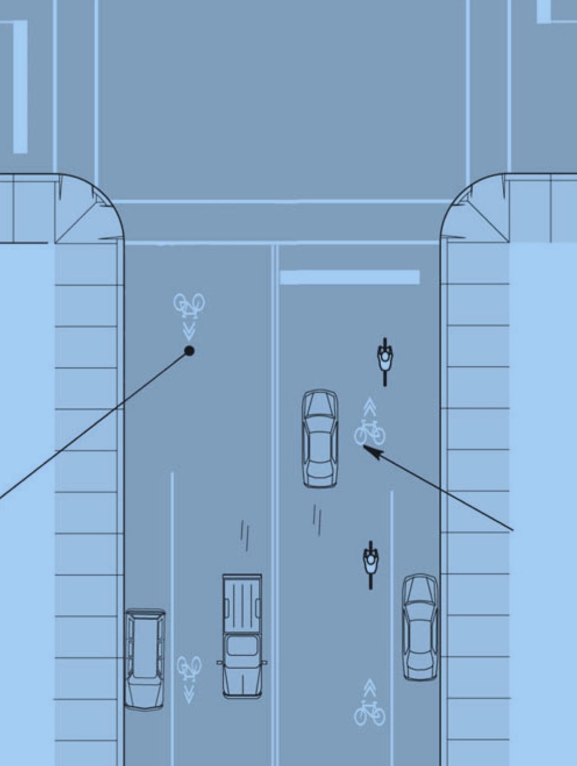
23 A bikeway network will send a clear message to both bicyclists and motorists that road space is to be used by everyone. Identify All Types of Bikeways What is a bikeway? A bikeway is a street specifically enhanced to accommodate bikes safely and efficiently and is shared with all other modes of transportation. What types of bikeways exist? One-Way Lane a portion of a street reserved for use by bikes only on one side of the street and running in one direction, usually made distinct by a stripe of paint and signage. Two-Way Lane a portion of a street reserved for use by bikes only on both sides of the street and running in both directions, usually made distinct by a stripe of paint and signage. Shared Use Lane a facility where markings are present to inform motorists that they must share the road with bicyclists. These are typically marked with shared lane markings, or sharrows. Sharrows being unveiled on High Street in Columbus miles of shared use lanes as a part of its bicycle master plan (Bike Walk Twin Cities). Columbus, Ohio installed its first sharrow along High Street, it main commercial corridor, in May of In addition, the city will be installing 188 more sharrow markings in the coming months. How will signage encourage sharing the road? Currently, Lakewood is underserved by bicycle signage. Using a custom design (pictured below), our plan will require that signage be present wherever bike racks are located throughout the city. This will not only inform bicyclists of parking locations but will also notify motorists that road space is to be used by everyone. Develop a Network Composed Entirely of Shared Use Lanes. Given that Lakewood s streets are not wide enough to accommodate segregated bicycle lanes, the best and most practical option are shared use lanes. Our vision maximizes Lakewood s potential to be one of the most bike-friendly communities by How does a Shared Use Lane work? A shared use lane informs motorists that bicycles and cars travel together. A shared lane marking or a sharrow is placed within the traffic lane. These white markings are approximately three feet wide by eight feet tall and are placed no further than 250 feet apart from each other (San Francisco Department of Transportation). Where have Shared Use Lanes worked? Minneapolis, which was recently named the most bicycle-friendly city in the country, has over 57 Bike Parking Sign (Proposed) DRAFT 23
24 Rinse, lather, and repeat. As the saying goes, we will educate, raise awareness, and continually remind residents that bicycling is transportation through directed programs and initiatives. Partner with Our Police Department to Encourage Bike Safety Proposed Enforcement Guidelines Pro-actively enforce traffic laws relating to bicycle safety, while at the same time, emphasizing education initiatives. Conduct multiple Bicycle Enforcement Studies by choosing a widely used bicycle intersection and enforcing bike laws. Enforce bicycle registration requirements. The City may propose that following bike violations have a fee: Failure to obey traffic direction Wearing headphones No headlights Police officers in California direct children and their bikes Integrate Our Public Transit System with Our Bike Network Linking RTA with Bicycle Network RTA allows transit riders to bring their bikes with them onboard the train or bus. Currently, the city is serviced by three bus lines (55, 26 and 25) as well as two rapid rail stations (Madison & West 117 th and Triskett). By expanding the bicycle network to run along streets where these bus lines and rail station exist, the city aims to encourage multi-modal transportation. RTA buses can accommodate bicyclists Expand Our Education and Outreach Programs Proposed Programs for Education The Department of Planning will partner with Lakewood Public Schools to adopt a bike education program for all schools to follow. Primarily the education program will create further awareness about bike safety with our youth, with the goal of instilling the importance of following rules on the road at an early age. Our youth will educate the community at-large about our bike network by following the rules and leading by example. Outreach Initiatives A public outreach campaign must be undertaken in order to promote bicycling. Using the city s current resources and partnering with local businesses and nonprofits, the City proposes the following outreach initiatives Billboards: The city will promote bicycling through a unified message to share the road utilizing its existing city-owned billboards. Bike Maps: An effective tool for informing residents of the City s bicycle network, bike maps will be distributed to businesses, institutions and public facilities. Mural: Lakewood will establish itself as the Bicycle Capital of Northeast Ohio. See mural below. Promotional Materials: T-shirts and bumper stickers. Continue onto the next page for examples of the proposed outreach initiatives. DRAFT 24


25 Billboards Before After Bike Maps DRAFT 25


26 Mural: Lakewood as The Bicycle Capital of Northeast Ohio Before After Promotional Materials: Bumper Stickers and T-Shirts DRAFT 26
27 Madison Avenue is 2.7 miles from West 117 th to Riverside. The proposed reconfiguration of the Avenue would improve the multi-modal use of the corridor and create a safer and more effective variety of transportation options, Walk, Bike, Drive, Bus, & Train. All of these options are currently not possible due to the existing condition and configuration of Madison Avenue. The improved corridor would connect the West 117 th Rapid and Bus Station on the east end with Riverside Drive and the Rocky River Reservation on the west end. Parks Three city-owned parks directly front on the corridor and Cleveland Metroparks Rocky River Reservation via Riverside Drive is the western terminus Madison Park Total size: 17 acres Madison Park Pool Number of Visitors: 22,544 (June-Labor Day) Rocky River Reservation Total lengths of All Purpose Trail (APT): 13.6 miles Total visitation including commuter traffic: 8,144,156 Total visitation for recreation purpose: 3,970,915 RTA Rapid (Madison and West 117 th Station) Total Daily Ridership (2010): 1,200 to 1,800 (boarding and arrivals) Total Weekly Ridership (x5 Business Week): 6,000 to 9,000 Totals Annual Ridership (x52): 312,000 to 468,000 Madison Avenue in its current condition Madison Avenue by the Numbers Schools (Enrollment) Due to Lakewood not having a school bus system, many students travel to school by walking, biking or using public transportation. Thousands of students commute via the Madison Corridor on a daily weekday basis from September through June. Counting morning and afternoon trips equals more the 6,000 daily trips for the four schools on and around Madison. Lakewood High School (Bunts and Madison): 1900 Harding Middle School (Madison and Wagar): 675 Harrison Elementary (One Block South of Madison on Quail): 450 Roosevelt Elementary (One Block South of Madison on Athens): 300 Library (Average Weekly Visitors) Lakewood Public Library (Madison Branch): 3,800-4,000 Proposed Sharrows along Madison Avenue DRAFT 27

28 DRAFT 28


29 Design Standards for Shared Use Lanes The Ohio Department of Transportation (ODOT) establishes standards for the design and configuration of bicycle facilities. For a complete description of the design standards for the design of bicycle facilities, please click here. Signage Approved by the Ohio Department of Transportation (ODOT) Bicycle Warning Sign This sign alerts motorists that bicyclists may be present on a roadway. Also optional is a yellow share the road sign which sits beneath it. Bike Parking Sign Design Standards The City of Lakewood requires that the following standards be followed for the design, installation, and upkeep of bicycle parking signs: Signage Proposed by the City of Lakewood Bike Parking Sign This sign is inspired by bicycle signage in the Netherlands and would alert bicyclists of bicycle parking throughout the city. Shared Use Lane Configuration Design Standards for Signage The City of Lakewood will consider both the signage design standards established by ODOT as well as proposed bike parking signage for both Detroit and Madison Avenue. ODOT Design Standards ODOT establishes standards for the design and configuration of bicycle signage. For a complete description of the design standards for the design of bicycle facilities, please click here. Bike Parking Sign Design Standards Bike Rack Installation Guide In response to the growing number of persons using bicycles as a primary means of transportation and for recreation, the City of Lakewood seeks to facilitate and encourage the use of bicycles throughout the city. In partnership with Lakewood Businesses, The Department of Planning has established criteria for including bicycle parking for residents. The following guidelines detail the best and required configuration for bicycle parking, so as to efficiently and DRAFT 29
30 effectively use available space for cyclists and pedestrians alike. This guide will help you navigate the city s requirements and recommendations for bike parking; please contact the Planning and Development Department at for consultation and guidance in the permitting process. 4. Bike racks must allow for at least 6 feet of open sidewalk area in width. 5. Bike racks cannot otherwise restrict accessibility to right-of-ways and entrances, pose difficulty to such, or present concern to physical safety. Objectives To provide ample parking for cyclists in proportion to parking for motorists To provide safety of public and private property, for cyclists, motorists and pedestrians To enhance the streetscape and livability of the community Permitted Bicycle Racks 1. Inverted U style rack and Post and Ring (Bollard) style rack: These racks are required in commercial districts. Both types are good for tight spaces and accommodating as many cyclists as possible, and are very cost effective. These racks also offer dual points of contact for a bike frame, which allows cyclists to securely lock their parked bikes. The placement of these racks should be in highly visible places, and should not hinder pedestrian traffic or access in any way. Bike racks cannot be located in front of entryways, bus stops, loading and unloading areas, or any area where they would impede a business or function. Cost: Roughly $250/each (Cost of U-Rack) 2. Custom-design bike racks may be considered on a case-by-case basis. These racks should follow the same guidelines as inverted U and Post and Ring racks. 3. On-Street Bike Corrals cost the city or merchants around $3-$4,000 (Cost of Bike Corrals) Location Restrictions 1. Bike racks cannot be within 5 feet of access to a building, park or pathway. 2. Bike racks must be 5 feet from the corner of two perpendicular connecting streets. 3. Bike racks must be 5 feet from crosswalks. DRAFT 30
31 DRAFT 31
32 Cleveland council OKs 'Complete and Green Streets' legislation, The Plain Dealer, p. 14, retrieved from d_council_oks_complete.html Bicycling Info, Pedestrian & Bicycle Information Center, p. 30 < cfm> Bike Walk Twin Cities: A Non Motorized Transportation Pilot Program, 2010 Campaign for Active Transportation (Case Statement). Rep. Rails to Trails, Web. 9 Nov < /whatwedo/case_statements/minneapolis%20case %20Statement.pdf>. Center for Disease Control and Prevention, Prevalence of Obesity Among Children and Adolescents: United States, Trends Through , p. 11 Americans Are Less Healthy, retrieved from d_07_08/obesity_child_07_08.htm City of Cincinnati, Bicycle Transportation Plan, p. 12, retrieved from City of Cleveland, Cleveland Bikeway Master Plan, p. 14, retrieved from ywide.pdf City of Columbus, Ohio Bicentennial Bikeway Master Plan, p. 12, retrieved from City of Lakewood, Lakewood Community Vision, p. 19, retrieved from ty_vision_1993.pdf City of Lakewood, Parks System Strategic Plan, p. 19, retrieved from emstrategicplan.pdf City of Shaker Heights, The, Bike Route Plan, p. 13 retrieved from, andhikes-leavingthecarathome.asp Cleveland Critical Mass Photograph. Cleveland, Ohio. UrbanOhio. Web. 9 Nov < pic= >. Cleveland Heights Joins Bike Network Study, The Plain Dealer, p. 13 retrieved from _bike_n.htmlthe Cost of U-Rack, p. 30 Bicycle Coalition of Greater Philadelphia ng%20racks%20fact%20sheet.pdf Cost of Bike Corrals, p. 30 City of San Diego Engineering Department, High Street Sharrow Photograph. Columbus, Ohio. First High Street Sharrow Unveiled Today. Columbus Underground, 17 May Web. 9 Nov < League of American Bicyclists, American Community Survey Bicycle Commuting Trends, 2000 to 2008, p. 11 retrieved from /acs_08_summary.pdf Northern Ohio Areawide Coordinating Agency (NOACA), Regional Bicycle Transportation Plan, p. 13 & 19 retrieved from Ohio Department of Transportation, Traffic Controls for Bicycle Facilities, p. 30, retrieved from raffic/publications2/ohiomutcd/documents/2005 OMUTCD_Revision2_file09_Part9_TrafficControlfor Bicycle_031711_bookmarked.pdf DRAFT 32
33 A Promising Start for Minneapolis Bike-Sharing Photograph. Minneapolis, MN. Streetsblog. 11 Nov Web. 9 Nov < San Francisco Department of Parking & Traffic, San Francisco's Shared Lane Pavement Markings: Improving Bicycle Safety (p.4), p. 30, retrieved from /Bike_Plan/Shared%20Lane%20Marking%20Full%20 Report pdf Sharrow. Photograph. Seattle, WA. Cascade Bicycle Club. 10 May Web. 9 Nov < DRAFT 33
34 Total Responses: 205 Cyclists by Gender, Lakewood Reason for Cycling, Lakewood Male Female Work/Commute Recreation/Pleasure Other 45% 14% 25% 55% 61% Cyclists by Age, Lakewood Frequency of Cycling, Lakewood Under Everyday 5-6 times 3-4 times 1-2 times Infrequently 6% 10% 21% 31% 31% % 10% 20% 30% 40% DRAFT 34
35 Length of Residency 0-2 years 9% 3-6 years 12% 7-10 years 11% years 14% 15 + years 50% Don t live here 5% Major Streets Used by Cyclists Lake 15% Clifton 15% Detroit 14% Hilliard 9% Franklin 8% Madison 11% Athens 4% W. 117th 2% Bunts 3% Warren 4% McKinley 4% Riverside 8% Other 3% When Cyclists Ride Morning 19% Afternoon 16% Evening 21% Weekdays 17% Weekends 26% Public Transit Ridership Never 83% 1-2 times 12% 3-4 times 2% 5-6 times 2% Everyday 1% Educational Attainment HS/GED 8% Associate 7% BA 46% MA 27% PhD/JD 6% Trades/Other 6% Cyclists by Household Type Single-Family 70% Double 14% Apartment 11% Condo 3% Other 2% DRAFT 35
36 How Often Does Your Child Wear a Helmet? Always Sometimes Never Total Responses: 100 Distance Traveled to School 20% Less the ¼ mile ½ mile 1 mile 2.5 miles Over 2.5 miles 20% 60% 15% 9% 22% 26% 28% Mode of Transportation to School (Top 2 Responses)* Walk 43.20% Bike 21.60% *Other responses included Family Vehicle, Carpool, & Public Transit 6th grade 5th grade Age Child First Walked/Biked to School Without Adults 16.00% 18.70% Most frequently identified concerns regarding commute to school 1 Amount of traffic along route 2 Speed of traffic along route 3 Weather/Climate 4 Difficult intersection crossings 5 Condition of sidewalk 6 Condition of street 7 Distance 4th grade 22.70% 3rd grade 22.70% 0% 5% 10% 15% 20% 25% DRAFT 36
37 DRAFT 37
Downtown Tampa Transportation Vision
 Downtown Tampa Transportation Vision Executive Summary August 1, 2006 Hillsborough County Metropolitan Planning Organization County Center, 18 th Floor Tampa, Florida 33602 813-272-5940 www.hillsboroughmpo.org
REGIONAL NON-MOTORIZED TRANSPORTATION NETWORK
 Chapter 10 Bicycle and Pedestrian SAFETEA-LU legislation requires that non-motorized users be considered in the LRTP. The legislation allows for bicycle and pedestrian safety to be incorporated into the
New Jersey SRTS Travel Plan Guide
 New Jersey SRTS Travel Plan Guide Prepared For: Funded By: Prepared By: New Jersey Department of Transportation Federal Highway Administration Alan M. Voorhees Transportation Center Edward J. Bloustein
- FREE! - The Official San Francisco BIKE GUIDE. 1st Edition
 - FREE! - The Official San Francisco BIKE GUIDE 1st Edition SF BIKE LAWS SAN FRANCISCO BICYCLISTS MUST: Yield to People Walking Whether they re in a crosswalk or not, ALWAYS yield to people walking. Stop
Stone Way N Rechannelization: Before and After Study. N 34th Street to N 50th Street
 City of Seattle Department of Transportation Stone Way N Rechannelization: Before and After Study N 34th Street to N 50th Street May, 2010 INTRODUCTION Population density in Seattle is increasing within
SAN DIEGO - A BICYCLE FRIENDLY CITY
 SAN DIEGO - A BICYCLE FRIENDLY CITY MANY OPPORTUNITIES FOR IMPROVEMENT SUMMARY The designated bicycle paths and lanes in the City of San Diego (City) are often substandard because of their location and
Needs Analysis. Long Beach Bicycle Master Plan. Bicycle Commuter Needs. LONG BEACH BICYCLE MASTER PLAN Needs Analysis
 Long Beach Bicycle Master Plan Needs Analysis The purpose of reviewing the needs of commuter and recreational bicyclists is twofold: (1) it is instrumental when planning a system which must serve both
Lincoln Downtown Master Plan Update
 Lincoln Downtown Master Plan Update Table of Contents Executive Summary........................................... 1 Complete Streets Framework.................................... 3 Promenade Creating
Examples of Transportation Plan Goals, Objectives and Performance Measures
 Examples of Transportation Plan Goals, Objectives and Performance Measures The next step in the Long Range Transportation Plan (LRTP) process is to develop goals, objectives, and performance measures.
 Walkable Communities Florida Department of Transportation State Safety Office Pedestrian and Bicycle Program April 1995 www.dot.state.fl.us/safety Twelve Steps for an Effective Program Page 1 Twelve Steps
Safety Evidence for Bicycling
 Photo: Boegh (Flickr) Cycling in Cities Research Program School of Population & Public Health The University of British Columbia Faculty of Health Sciences Simon Fraser University Driving near bicyclists
Smart Cycling IN SANTA MONICA SANTA MONICA POLICE DEPARTMENT BE SMART. BE VISIBLE. BE ATTENTIVE. HAVE FUN!
 Smart Cycling IN SANTA MONICA BE SMART. BE VISIBLE. BE ATTENTIVE. HAVE FUN! Safety Tips and Rules of the Road for Cyclists SANTA MONICA POLICE DEPARTMENT Rules of the Road Drivers, bicyclists, and pedestrians
The Trust for Public Land CREATING PARKS FOR PEOPLE CONNECTING CLEVELAND THROUGH PARKS AND TRAILS
 The Trust for Public Land CREATING PARKS FOR PEOPLE CONNECTING CLEVELAND THROUGH PARKS AND TRAILS Lake Link Trail Corridor Location/Context The Proposed Trail Corridor travels along vacated Road and Railroad
Bicycle riding is a great way to get into shape
 Bicycle riding is a great way to get into shape and have fun. To remain safe on Illinois roads, it is important to follow the same traffic safety laws that govern vehicle drivers. No amount of bicycle
In 2005, the City of Pasadena, CA, USA, with the support of consultants,
 Creating a Citywide Safe Routes to School Program: Pasadena, CA, USA s Step-by-Step Approach In 2005, the City of Pasadena, CA, USA, initiated development of a comprehensive Safe Routes to School Program.
Motorcycle & Pedestrian Master Plans in Indianapolis, Indiana
 PROJECT PURPOSE The Warsaw + Winona Lake Bicycle and Pedestrian Master Plan establishes a comprehensive framework for a connected bicycle and pedestrian system that will be used for both recreation and
A Bicycle Accident Study Using GIS Mapping and Analysis
 A Bicycle Accident Study Using GIS Mapping and Analysis Petra Staats, Graduate Assistant, Transportation Policy Institute, Rutgers University, New Brunswick, NJ, USA pstaats@eden.rutgers.edu Summary Surveys
RULES OF THE ROAD BY LWTL Staff Writer
 RULES OF THE ROAD BY LWTL Staff Writer Publisher s Note This is the First of a Three Part Series on Pedestrian and Bicycle Safety. This First Part is made available to all readers. The final two parts
How To Know The Laws Of A Bike Ride In California
 The Rules Of The Road For Colorado Cyclists Your Rights and Responsibilities as a Colorado Cyclist Crawford Weiss, LLC Phone (303) 741-0249 www.denversaccidentlawyer.com 2015 The Rules Of The Road For
EPA Technical Assistance for Sustainable Communities Building Blocks
 EPA Technical Assistance for Sustainable Communities Technical Assistance Tool: Complete Streets Deerfield Beach, Florida February 16, 2012 To: CC: Amanda Martinez, City of Deerfield Beach Roger Millar,
VISION, DESIGN PRINCIPLES & OVERALL PLANNING STRATEGY
 3 VISION, DESIGN PRINCIPLES & OVERALL PLANNING STRATEGY The overall planning strategy for the Bank Street CDP is to ensure that future development is undertaken in a coordinated and planned approach, supported
BEST PRACTICES DISCUSSION / BICYCLE MASTER PLAN
 BEST PRACTICES DISCUSSION / BICYCLE MASTER PLAN This memo highlights for each draft policy area to be included in the Bicycle Master Plan key objectives, a summary of relevant focus group comments, and
Chapter 1: Background
 Chapter 1: Background 1.1 Trends in Bicycle Ridership and Collisions in Toronto Toronto has relatively high levels of bicycle traffic on its downtown streets. On a typical weekday, bicycles make up roughly
North Avenue Corridor Study. Advisory Committee Meeting #5 June 11, 2014
 North Avenue Corridor Study Advisory Committee Meeting #5 June 11, 2014 Agenda Welcome and introductions Concept refinement and evaluation: Public meeting and web survey General cross-section concepts
5 Tips to Improve Biking in San Francisco
 SAN FRANCISCO BICYCLE COALITION 2012 2017 Strategic Plan OVERALL GOAL BY 2017, AT LEAST HALF OF SAN FRANCISCANS WILL BICYCLE OCCASIONALLY, AND AT LEAST ONE-QUARTER WILL BICYCLE FREQUENTLY OR AT LEAST A
Pedestrian & Bicycle Plan
 RAMSEY COMMUNITIES COUNTYWIDE Pedestrian & Bicycle Plan PRIMER: LEGAL FRAMEWORK PRIMER: LEGAL FRAMEWORK Walking and Biking for All e 2 CHAPTER 2: Walking and Biking for All This page intentionally left
SEPTEMBER 2015 SCOPE OF WORK. MONTGOMERY COUNTY PLANNING DEPARTMENT M-NCPPC MontgomeryPlanning.org
 SEPTEMBER 2015 SCOPE OF WORK MONTGOMERY COUNTY PLANNING DEPARTMENT M-NCPPC MontgomeryPlanning.org table of contents table of contents... 1 introduction... 2 planning context... 2 purpose of master plan...
Bicycle Safety Quiz Answers Parental Responsibilities
 Bicycle riding is a great way to get into shape and enjoy the outdoors. To remain safe on Illinois roads, it is important to follow the same traffic safety laws that govern vehicle drivers. No amount of
KENTUCKY TRANSPORTATION CABINET. Department of Rural and Municipal Aid. Office of Local Programs
 KENTUCKY TRANSPORTATION CABINET Department of Rural and Municipal Aid Office of Local Programs Office of Local Programs Transportation Enhancements Safe Routes to School Congestion Mitigation and Air Quality
SAN FRANCISCO BICYCLE COALITION
 SanFranciscoBicycleCoalitionNovember2010CandidateQuestionnaire Emailyourresponsetomarc@sfbike.orgnolaterthanFridayAugust16,2010 SAN FRANCISCO BICYCLE COALITION November 2010 Supervisor Candidate Questionnaire
CHAPTER II. BIKING CINCY: STATE OF THE CITY IN 2010
 CHAPTER II. BIKING CINCY: STATE OF THE CITY IN 2010 Prior to developing the plan goals and objectives, an analysis of bicycling conditions throughout the City was undertaken. Additionally, an inventory
Bicycle Friendly Business Districts 2.0
 Business Improvement Districts (BIDs) and Main Street Associations looking for innovative ways to bring community building, economic gardening and new funding opportunities to themselves and their members
Pilot Staff Bike Share Project. Induction Notes
 Pilot Staff Bike Share Project Induction Notes www.capetown.gov.za/travelsmart travel.smart@capetown.gov.za Contents Contents... i Introduction.... 1 How do I get access to the bicycles?... 1 Location
GOALS, OBJECTIVES, AND EVALUATION MEASURES
 GOALS, OBJECTIVES, AND EVALUATION MEASURES The Tallahassee-Leon County MPO is developing its first Bicycle and Pedestrian Master Plan, a 20- year plan that provides guidance for the development of facilities
SAFE CYCLING GUIDE. 7th Edition
 SAFE CYCLING GUIDE 7th Edition BEFORE SETTING OUT A Check tire pressure B Check that the chain does not slip C Check the brakes D Check lights and reflectors: 1 A WELL-MAINTAINED BICYCLE is key 3 4 5 Adjust
Near Westside Neighborhood and University Avenue Corridor Transportation Study. Public Workshop #2. September 12 and 23, 2013
 Near Westside Neighborhood and University Avenue Corridor Transportation Study Public Workshop #2 September 12 and 23, 2013 Presentation Outline: Brief Review of Study Scope, Background, and Current Conditions
N Street Protected Bikeway
 N Street Protected Bikeway The N Street Protected Bikeway project was identified in the 2005 City of Lincoln Downtown Master Plan and the 2012 Downtown Master Plan Update as the completion of the last
SAFE CYCLING GUIDE. 6th Edition
 SAFE CYCLING GUIDE 6th Edition BEFORE SETTING OUT A WELL-MAINTAINED BICYCLE is key A Check tire pressure B Check that the chain does not slip C Check the brakes D Check lights and reflectors: 3 4 1 5 2
OVERVIEW PROJECT SUMMARY
 OVERVIEW Cesar Chavez showcases how to successfully redesign a primary arterial route into a neighborhood destination, improving modal share, water sensitive design, biodiversity and safety whilst maintaining
New York Bicycling Pocket Guide
 New York Bicycling Pocket Guide Prepared by the New York Bicycling Coalition About This Guide Getting around by bike is good for one s health and wallet, and the environment. But many people aren t sure
Education. Chapter 3. Education Encouragement Enforcement Engineering & Facilities Evaluation & Planning. Education Chapter 3
 Education Education Encouragement Enforcement Engineering & Facilities Evaluation & Planning Photo above: A woman and child ride on the road in Blackwater. Virginia Beach Bikeways and Trails Plan 2011
For more information, visit: rethinkingstreets.com
 For more information, visit: rethinkingstreets.com 37 Arterial Rehab Busy, multi-lane streets, often referred to as arterials, crisscross the landscape of our cities and suburbs. Alongside these wide thoroughfares,
ENGINEERING SOLUTIONS FOR DESIGNING YOUR SAFE ROUTES
 How to Get Started ENGINEERING SOLUTIONS FOR DESIGNING YOUR SAFE ROUTES Design Elements Selecting appropriate design treatments for school neighborhoods creates environments that address the needs of all
DESIGN ASSISTANCE APPLICATION
 DESIGN ASSISTANCE APPLICATION for FY 2016 NEW RIVER MULTI USE PATH: PINNACLE PEAK ROAD TO HAPPY VALLEY ROAD CITY OF PEORIA APPLICATIONS ARE DUE VIA ONLINE SUBMITTAL BY 10:00 AM ON MONDAY, JUNE 29, 2015
The New Mobility: Using Big Data to Get Around Simply and Sustainably
 The New Mobility: Using Big Data to Get Around Simply and Sustainably The New Mobility: Using Big Data to Get Around Simply and Sustainably Without the movement of people and goods from point to point,
Healthy, Equitable Transportation Performance Measures and Creative Place-making
 THE HONORABLE Mayor KEN WILBER, Karl Dean, CHAIRMAN Chairman Healthy, Equitable Transportation Performance Measures and Creative Place-making Rochelle Carpenter PSRC Bicycle/Pedestrian Advisory Committee
Chapter 9: Transportation
 Chapter 9: Transportation What is this chapter about? The goals and policies in this chapter convey the City s intent to: Create a coordinated, efficient, and more affordable multimodal transportation
Appendix J Santa Monica Travel Demand Forecasting Model Trip Generation Rates
 Appendix J Santa Monica Travel Demand Forecasting Model Trip Generation Rates SANTA MONICA TRAVEL DEMAND FORECASTING MODEL TRIP GENERATION RATES SUBMITTED BY: 201 Santa Monica Blvd., Suite 500 Santa Monica,
College of Southern Maryland. Hughesville Transportation Study
 College of Southern Maryland Project Overview Existing Conditions Transit Service Land Use CSM Student Demographics Recommendations Methodology Transit Recommendations Transportation Demand Management
CHAPTER 5-CMPO TRANSPORTATION VISION PLANS (2035 & BEYOND)
") Regional Transportation Plan 2035 28 CHAPTER 5-CMPO TRANSPORTATION VISION PLANS (2035 & BEYOND) The Cache Transportation Vision Plan shows roadway, bicycle, transit and pedestrian projects that attempt
Regional Transportation Plan 2035 28 CHAPTER 5-CMPO TRANSPORTATION VISION PLANS (2035 & BEYOND) The Cache Transportation Vision Plan shows roadway, bicycle, transit and pedestrian projects that attempt
SAFE Streets for CHICAGO
 Overview Each day, hundreds of thousands of Chicagoans walk or drive in the city. Ensuring their safety is the City s top priority. Over the past several years, Chicago has developed many successful strategies
Narrative Response/Attachment 1 (WisDOT 2014-2018 TAP- Second Round Application ID-SWBP22)
") Narrative Response/Attachment 1 (WisDOT 2014-2018 TAP- Second Round Application ID-SWBP22) 2. For Bicycle and Pedestrian Projects: Clearly indicate the location, length, width, surface materials, and any
Narrative Response/Attachment 1 (WisDOT 2014-2018 TAP- Second Round Application ID-SWBP22) 2. For Bicycle and Pedestrian Projects: Clearly indicate the location, length, width, surface materials, and any
NASHVILLE BICYCLE LAW 3/18/09
 NASHVILLE BICYCLE LAW 3/18/09 12.60.010 Compliance with Title 12 provisions. It is unlawful for any person to do any act prohibited or fail to perform any act required by Title 12 of this code. (Prior
BICYCLE TRANSPORTATION ANALYSIS
 2.1 Study Area The study area of the El Dorado County Bicycle Transportation Plan is the same as the planning area of the Regional Transportation Planning Agency (RTPA) of El Dorado County Transportation
Goals & Objectives. Chapter 9. Transportation
 Goals & Objectives Chapter 9 Transportation Transportation MISSION STATEMENT: TO PROVIDE A TRANSPORTATION NETWORK CAPABLE OF MOVING PEOPLE AND GOODS EFFICIENTLY AND SAFELY. T he transportation system
Schenk-Atwood Neighborhood Business District Master Plan
 Schenk-Atwood Neighborhood Business District Master Plan Prepared for the Schenk-Atwood Revitalization Association (SARA) and the City of Madison SCHREIBER/ANDERSON ASSOCIATES, INC. BEST Real Estate Group,
Tennessee Traffic Laws Relating to Bicycles A HANDBOOK FOR MOTORISTS & BICYCLISTS
 Tennessee Traffic Laws Relating to Bicycles A HANDBOOK FOR MOTORISTS & BICYCLISTS About the Knoxville Regional Bicycle Program The Knoxville Regional Transportation Planning Organization (TPO) coordinates
PEDESTRIAN LAWS OF NORTH CAROLINA
 PEDESTRIAN LAWS OF NORTH CAROLINA Under North Carolina law, pedestrians have the right of way at all intersections and driveways. However, pedestrians must act responsibly, using pedestrian signals where
Proposal 1. I. M. Writer 520 Safe Drive St. Anytown, Anystate, USA 01000 (555) 555-1212. October 13, 2004
 555-1212. October 13, 2004") Proposal 1 Cover letter I. M. Writer 520 Safe Drive St. Anytown, Anystate, USA 01000 (555) 555-1212 October 13, 2004 Mr. David Decider Director, Policy Branch Department of Highways 759 Main Rd. E. Suite
Proposal 1 Cover letter I. M. Writer 520 Safe Drive St. Anytown, Anystate, USA 01000 (555) 555-1212 October 13, 2004 Mr. David Decider Director, Policy Branch Department of Highways 759 Main Rd. E. Suite
STREETS -- BICYCLES -- PATHS
 STREETS -- BICYCLES -- PATHS RCW 35.75.050 Bicycle road fund -- Sources -- Use. The city or town council shall by ordinance provide that the whole amount or any amount not less than seventy-five percent
Statewide Survey on Bicycle and Pedestrian Facilities
 Statewide Survey on Bicycle and Pedestrian Facilities Prepared for: Florida Department of Transportation Safety Office Project Number: PS-05-08-07 Project Manager: Pat Pieratte Prepared by: Center for
28 CHAPTER 4 TRANSPORTATION. Chapter 4 Transportation
 28 CHAPTER 4 TRANSPORTATION Chapter 4 Transportation Introduction An efficient, safe, and connected transportation system is a key component to a vibrant, healthy city. Convenient access to jobs, schools,
d r a f t Division Street: 15.4 du/a Damen Avenue: 14.1 du/a Western Avenue: 12.8 du/a
 Transit [take transit: We live in the City, people. We can t expect to have parking. ] The ability of people to travel by transit is not only an equity issue, it is a matter of economic vitality for the
Topic 2 11/28/2012 Blocks & Street Network
 TOPIC 2 Blocks & Street Network Implementation Note: 1. Some recommendations are summarized in the tables herein. For complete recommendation language, please see the. 2. Recommendations referenced in
ORANGE COUNTY TRANSPORTATION AUTHORITY. Final Long-Range Transportation Plan - Destination 2035. Attachment A
 ORANGE COUNTY TRANSPORTATION AUTHORITY Final Long-Range Transportation Plan - Destination 2035 Attachment A DESTINATION 2035 DESTINATION 2035 EXECUTIVE SUMMARY ATTACHMENT A Moving Toward a Greener Tomorrow
BEST PRACTICES. Smart Transportation is a key concept for the Paoli Roadway Improvement Project.
 Smart Transportation Smart Transportation is a key concept for the Paoli Roadway Improvement Project. PennDOT s Smart Transportation Guidebook (2008) outlines a comprehensive approach to transportation
Florida Avenue Multimodal Transportation Study. June 19, 2013
 Florida Avenue Multimodal Transportation Study June 19, 2013 Today s Agenda Team & project introduction Project Timeline What you said Tools we use Mapped data and what clues it can provide Highlights
BICYCLE CRASH DATA ANALYSIS FOR HILLBOROUGH COUNTY
 BICYCLE CRASH DATA ANALYSIS FOR HILLBOROUGH COUNTY SEPTEMBER, 2000 Hillsborough County Metropolitan Planning Organization 601 E. Kennedy Blvd., 18th Floor P.O. Box 1110 Tampa, Florida 33601-1110 (813)
Back to School Car Safety. Direct Buy Warranty Staff September 19, 2014
 Back to School Car Safety Direct Buy Warranty Staff September 19, 2014 It s back to school season, and that means kids are picking out new clothes, putting on their backpacks, and hitting the road to get
Bicycle Laws in North Carolina and the U.S.
 Bicycle Laws in North Carolina and the U.S. Passing Cyclists in No-Passing Zones Several states, including Colorado, Maine, Mississippi, Ohio, Pennsylvania, Utah and Wisconsin have laws allowing motorists
12MAP-21, a funding and authorization bill to govern U.S. federal surface MONITORING IMPLEMENTATION AND PERFORMANCE
 MONITORING IMPLEMENTATION AND PERFORMANCE 12MAP-21, a funding and authorization bill to govern U.S. federal surface transportation spending, creates a data-driven, performance-based multimodal program
Downtown South Salt Lake Redevelopment City of South Salt Lake
 Project Information LOCAL PLANNING RESOURCE PROGRAM 2015 Downtown South Salt Lake Redevelopment City of South Salt Lake Overview of Objectives: Building a downtown city center could be the most significant
Overview of the Travel Demand Forecasting Methodology
 Overview of the Travel Demand Forecasting Methodology Prepared by the Central Transportation Planning Staff (CTPS) Authors: Scott A. Peterson, Manager Ian Harrington, Chief Planner March 29, 2008 1 OVERVIEW
First Transit Contra Flow Lane in Downtown San Francisco
 Introduction First Transit Contra Flow Lane in Downtown San Francisco Javad Mirabdal, Bond Yee Traffic congestion places a tremendous burden on transit vehicles in cities worldwide. San Francisco, located
Bicycle Safety Enforcement Action Guidelines
 Introduction Bicycle Safety Enforcement Action Guidelines People ride bicycles for many different reasons: fitness, recreation, or for transportation. Regardless of the reason for riding, bicyclists young
PEDESTRIAN-BICYCLIST SUBCOMMITTEE MEETING TECHNICAL ADVISORY COMMITTEE
 PEDESTRIAN-BICYCLIST SUBCOMMITTEE MEETING TECHNICAL ADVISORY COMMITTEE Houston-Galveston Area Council: Conference Room A (Second Floor) Thursday, October 23, 2014 9:30 A.M. 11:30 A.M. Members in Attendance
30 Years of Smart Growth
 30 Years of Smart Growth Arlington County s Experience with Transit Oriented Development in the Rosslyn-Ballston Metro Corridor A Presentation by the Arlington County Department of Community Planning,
Measuring the Street:
 Measuring the Street: New Metrics for 21st Century Streets 1 Measuring the Street: New Metrics for 21st Century Streets New York City s streets are constantly called on to the meet new and varied needs
Atlanta, Georgia Road Test
 1. When driving your car Into traffic from a parked position, you should: A. Sound your horn and pull Into the other lane. B. Signal and proceed when safe. C. Signal other traffic and pull directly into
Selected Parking Regulations from the New Orleans City Code (The quotation marks have been omitted in the cited material).
.") I. Parking Violations: * Your vehicle can be towed for almost any parking offense. * Parking fines vary, and all included fines approximate the fines as of August 4, 2014. * If you neglect to pay your
I. Parking Violations: * Your vehicle can be towed for almost any parking offense. * Parking fines vary, and all included fines approximate the fines as of August 4, 2014. * If you neglect to pay your
Where Do We Want to Go? How Can We Get There?
 Where Do We Want to Go? How Can We Get There? The BRTB has adopted nine goals, with supporting strategies, performance measures, and performance targets. Together, these goals, strategies, measures, and
ORDINANCE NO. Section 21-197. Traffic laws apply to persons riding bicycles, shall be amended to read as follows:
 ORDINANCE NO. AN ORDINANCE TO AMEND CHAPTER 21, ARTICLE V, CODE OF ORDINANCES, CITY OF MEMPHIS, TO UPDATE REGULATIONS REGARDING THE OPERATION OF BICYCLES WITHIN THE CITY OF MEMPHIS WHEREAS, the current
Mayors Welcome Strong Surrey Votes Yes Coalition Support. Yes Vote Would Vastly Improve Transit and Transportation in Fast Growing City
 Mayors Welcome Strong Surrey Votes Yes Coalition Support Yes Vote Would Vastly Improve Transit and Transportation in Fast Growing City February 11, 2015 Vancouver, BC The Mayors Council on Regional Transportation
ZONING ADMINISTRATOR BULLETIN NO. 9. Relevant Code Sections:
 Bicycle Parking Requirements: Design and Layout Section 307 of the Planning Code mandates the Zoning Administrator to issue and adopt such rules, regulations and interpretations as are in the Zoning Administrator
Impact of transportation infrastructure on risk of injuries while cycling
 Impact of transportation infrastructure on risk of injuries while cycling. Non-Intersections 2. Intersections Results of the Bicyclists Injuries and the Cycling Environment Study Kay Teschke, Conor Reynolds,
ARC Bike/Ped Plan Equity Discussion. Presented to ARC Bike/Ped Plan Equity Advisory Group July 29 th, 2015
 ARC Bike/Ped Plan Equity Discussion Presented to ARC Bike/Ped Plan Equity Advisory Group July 29 th, 2015 The Bicycle 1973 ARC A Plan & Program for Its Use as a Mode of Transportation & Recreation The
A Guide to Safe Bicycling in Hawai i
 A Guide to Safe Bicycling in Hawai i Sharing the Road: A Guide to Safe Bicycling in Hawai i What Motorists & Bicyclists Should Know Everyone has the right to be safe on Hawai i s roads. Law of the Splintered
Associati. The Annex Residents Association. The Annex Residents Association Cycling Policy Adopted by the Board, January 13, 2011.
 Associati The Annex Residents Association The Annex Residents Association Cycling Policy Adopted by the Board, January 13, 2011 The objective of these recommendations is to establish a set of guiding principles
Performance Measures for a Sustainable Transportation Network Pasadena s Approach Frederick C. Dock, Ellen Greenberg, Mark Yamarone
 Performance Measures for a Sustainable Transportation Network Pasadena s Approach Frederick C. Dock, Ellen Greenberg, Mark Yamarone Abstract. As California cities move into the second decade of the 21st
Indianapolis SDAT. Neighborhood Restoration
 Neighborhood Restoration Working Toward a Sustainable Future live * work * play October 30 th, 2009 Message Hear concerns Build consensus Provide Recommendations Transition from Fragmentation/disconnect
RESOLUTION NO. 74443
 RD:AGN:ERD RES. NO. 74443 5/27/08 RESOLUTION NO. 74443 A RESOLUTION OF THE COUNCIL OF THE CITY OF SAN JOSE APPROVING A REVISED COUNCIL POLICY 5-6 ENTITLED TRAFFIC CALMING POLICY FOR RESIDENTIAL NEIGHBORHOODS
Egg Harbor City School District Safe Routes to School Travel Plan
 Egg Harbor City School District Safe Routes to School Travel Plan Charles L. Spragg Elementary & Egg Harbor Community School August 2012 NEW JERSEY Safe Routes to School Egg Harbor City School District
MILWAUKEE. Plan. comprehensive DEPARTMENT OF CITY DEVELOPMENT MARCH, 2010 EXECUTIVE SUMMARY
 MILWAUKEE Plan DEPARTMENT OF CITY DEVELOPMENT MARCH, 2010 comprehensive CITYWIDE POLICY PLAN EXECUTIVE SUMMARY INTRODUCTION AND OVERVIEW I. OVERVIEW OF COMPREHENSIVE SMART GROWTH PLAN SERIES The series
Comprehensive Plan Policies that support Infill and Mixed Use
 Comprehensive Plan Policies that support Infill and Mixed Use Introduction A comprehensive plan provides a broad vision for the future growth of a community. It is often formulated using community visioning
Sir Francis Drake Boulevard Rehabilitation Project Bicyclist and Pedestrian Intercept Interviews Report
 Sir Francis Drake Boulevard Rehabilitation Project Bicyclist and Pedestrian Intercept Interviews Report Sir Francis Drake Boulevard Rehabilitation Project Bicyclist and Pedestrian Intercept Interviews
BICYCLE TRENDS IN CAMBRIDGE
 BICYCLE TRENDS IN CAMBRIDGE Cambridge promotes bicycling as a healthy, environmentally friendly way of getting around as an important part of the City's efforts to improve mobility and protect our environment.
Chapter 4 Communicating Livability Themes: A Strategic Approach
 Chapter 4 Communicating Livability Themes: A Strategic Approach Los Angeles, California Commuter Express Photo Credit: Southern California Association of Governments City of Lauderdale Lakes Welcome Sign
walkable Station spacing is key to successful, equitable bike share
 NACTO Bike SHARE equity Practitioners paper # April walkable Station spacing is key to successful, equitable bike share Across the United States, bike share programs offer new transportation options for
Evaluation of the Shared-Use Arrow
 Evaluation of the Shared-Use Arrow Table of Contents Page Evaluation of the Shared-Use ARROW Background... 1 ARROW Design... 1 ARROW Placement... 2 Wayne E. Pein William W. Hunter J. Richard Stewart Report
Bicycle Riding. WHAT ARE the. One Final Note... It is against the law to ride a bicycle under the influence of alcohol and/or drugs. (21200.
 One Final Note... It is against the law to ride a bicycle under the influence of alcohol and/or drugs. (21200.0 VC) Bicycle Riding WHAT ARE the CALIFORNIA HIGHWAY PATROL CHP 909 (12/11) OPI 013 94 75015