LCCS & GeoVIS for land cover mapping. Experience Sharing of an Exercise
|
|
|
- Lindsey Booth
- 7 years ago
- Views:
Transcription
1 LCCS & GeoVIS for land cover mapping Experience Sharing of an Exercise Forest Survey of India Subhash Ashutosh Joint Director

2 Study Area Topographic sheet 53J4 Longitude - 78ºE - 78º15'E Latitude - 30ºN - 30º15'N

3 Land cover/land use classification based on -LCCS Primarily Vegetated Area Primarily Non. Vegetated Area Terrestrial Cultivated & Managed Terrestrial Areas Aquatic/Regularly Flooded Natural & Semi-natural Terrestrial Vegetation Terrestrial Artificial Surfaces & Associated Areas Aquatic/Regularly Flooded Natural Water Bodies/ Snow/Ice Based on dichotomous Phase Plantation Orchards Agri. Farms Agri. Fallow Moist Sal Forest Moist Deciduous Without Sal Dry Siwalik Sal Khair Sissu Dry Deciduous Scrub Urban Built Up River Bed River-Perennial Based on Modular Hierarchical Phase

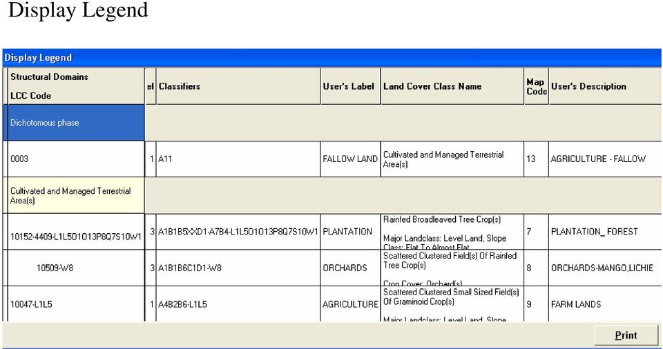
4 Display Legend
5 LAND COVER/LAND USE MAP WITH FOREST TYPES Area in percentage LEGEND MOIST SAL BEARING FOREST DRY SIWALIK SAL KHAIR-SISSU MOIST DECIDUOUS WITHOUT SAL DRY DECIDUOUS SCRUB PLANTATION FOREST ORCHARDS AGRICULTURE FARM AGRICULTURE - FALLOW URBAN BUILT UP RIVER - PERENNIAL RIVER BED Area in Sq.kms

6 Difficulties Encountered with the Software Sliver Polygon formation Steps followed Khair-Sisoo Plantation Contd

7 Contd Sliver polygon Delete option

8 Contd Remnants of the deleted polygon 5.

9 Contd Delete option - deleting an unwanted polygon inside a selected polygon Polygon to be deleted

10 Both the polygons got deleted Contd

11 Occurrence of Polygons without map code Polygons that cannot be selected Contd

12 Display of map code in different sizes Map codes are getting displayed on different size even when the size is set to the minimum

13 Error occurred while changing the map code to a user defined name When the software given map code is changed to a user defined name and when a new class is incorporated to the legend through edit legend option, the legend coding and symbology got altered

14

15 Other Problems Add a polygon It is unable to create a polygon inside an already existing polygon by add polygons option Area Estimation When polygons are exported to shape file the map codes remain intact and thereby giving correct area estimate. But if the shape is converted to arc coverage map codes are changing leading to erroneous area estimate. Print Command Print command is not working-message-report width is larger than the paper width even when report size is reduced to paper size. Sometimes LCCS Legend fail to get displayed while opening project even when the required details Viz., database, Tlegend and codes are provided. Only after reinstalling GeoVis and repairing files using LCCS V2.4.5 the LCCS Legend appears.

16 It is observed that to delineate narrow features like 3 rd order streams, the ROI has to be made almost in spatial extent with the feature to avoid acquisition of near by classes during classification. This accounts for considerable time and in fact it is almost equivalent to digitizing such features. Delineation of Features like Tree Outside Forest (TOF) is almost impractical.

17 Two Standard Forest Classification Systems in India Forest Cover (of FSI) Forest Type (Champion & Seth)
 Forest Type")
18 Nation-wide Forest Cover Mapping one of the mandates assigned to FSI by Govt of India biennial cycle State of Forest Report (SFRs) nine assessments so far main input for national level planning on forest cover

19 Forest Cover Mapping Salient Features Methodology biennial cycle digital interpretation of satellite data intensive ground truthing change maps accuracy assessment Analysis and output district wise area figures change matrix area figures for hill and tribal districts maps for all the areas on 1:50,000 scale

20 Flow Chart : Forest Cover Mapping Data download Geometrical rectification Contrast enhancement SOI toposheets 1:50,000 scale NDVI transformation Density slicing Masking Reference data Editing Making subsets of scene Preparation of change map Accuracy assessment Overlay of boundaries Post classification correction Ground truthing Area statistics Maps

21 Classes shown on a forest cover map LEGEND Very Dense Forests Moderately Dense Forests Open Forest Scrub Non-forest All lands with tree cover (including mangrove cover) of canopy density of 70% and above All lands with tree cover (including Mangrove cover) of canopy density between 40% and 70% above All land with tree cover (including mangrove cover) of canopy density between 10-40%. All forest land with poor tree growth mainly of small or stunted trees having canopy density less than 10 percent. Any area not included in the above classes.
22 Very Dense Forest Moderately Dense Forest Open Forest Scrub
23 FOREST COVER ASSESSMENTS BY FSI A brief history Cycle Year of Assessment Satellite & Sensor Resolution Scale I 1987 LANDSAT MSS II 1989 III 1991 LANDSAT TM 80m x 80m 30m x 30m 1:1million IV 1993 V 1995 VI 1997 VII 1999 VIII 2001 IRS-1B LISS-II IRS-1C LISS-III IRS-1C/1D LISS-III 36m x 36m 1:250,000 23m x 23m 23m x 23m 1:50,000 IX 2003 IRS-1D, LISS-III 23m x 23m 1:50,000
24 FOREST COVER ESTIMATES Assessment Year Data Forest Cover %of total Period (Sq.Km.) land area First , Second , Third , Fourth , Fifth , Sixth , Seventh , Eighth , Ninth ,78,
25 Classes shown on a forest cover map LEGEND Very Dense Forests Moderately Dense Forests Open Forest Scrub Non-forest All lands with tree cover (including mangrove cover) of canopy density of 70% and above All lands with tree cover (including Mangrove cover) of canopy density between 40% and 70% above All land with tree cover (including mangrove cover) of canopy density between 10-40%. All forest land with poor tree growth mainly of small or stunted trees having canopy density less than 10 percent. Any area not included in the above classes.
26 Forest Type Classification by Champion & Seth (1968) Most widely used classification system for India s forests Forests are classified into 5 major groups (6 in revised classification) based on climatic factors Major groups are divided into 16 type groups based on temperature and moisture content Type groups have been classified into 221 forest types based on location specific climate factors, floristic and succession stages
27 FOREST TYPES OF INDIA* MAJOR GROUPS Moist Tropical Forests Dry Tropical Forests Montane Temperate Forests Montane Subtropical Forests Sub Alpine Forests Alpine Scrub GROUPS Group 1-Tropical Wet Evergreen Forests Group 2-Tropical Semi-Evergreen Forests Group 3-Tropical Moist Deciduous Forests Group 4-Littoral And Swamp Forests Group 5-Tropical Dry Deciduous Forests Group 6-Tropical thorn Forests Group 7-Tropical Dry Evergreen Forests Group 8-Southern Subtropical Broadleaved Hill Forests Group 9-Subtropical Pine Forests Group 10- Subtropical Dry Evergreen Forests Group 11-Montane Wet Temperate Forests Group 12-Himalayan Moist Temperate Forests Group 13-Himalayan Dry Temperate Forests Group 14-Sub Alpine Forests Group 15-Moist Alpine Scrub Group 16- Dry Alpine Scrub SUB-GROUPS Sub-group- 22 Nos. TYPE GROUPS Type-group- 221 Nos. *As per Champion and Seth classification(1968)
28
29
30 e.g. 2B/C 12 /2S 3 - Sub Himalaya Secondary Wet Mixed Forest Ilex godajam 9left center), Ternsroemia japonica, Machius gamblei etc ; Kurseong Division, West Bengal 3A/C1/2S1 Andamans Secondary Moist Deciduous Forest Pterocarpus dalbergioides, Terminalia procera and other deciduous species; Kyitaung, Middle Andamans
31 Some Issues LCCS how can location specific forest types described in Champion & Seth Classification be assigned classes succession stages of vegetation may be incorporated Geo Vis saving signature files, break points
32
Estimation of Carbon Stock in Indian Forests. Subhash Ashutosh Joint Director Forest Survey of India sashutosh30@yahoo.com
 Estimation of Carbon Stock in Indian Forests Subhash Ashutosh Joint Director Forest Survey of India sashutosh30@yahoo.com Salient Features of the Methodology most comprehensive assessment so far a GIS
Remote Sensing and GIS Application In Change Detection Study In Urban Zone Using Multi Temporal Satellite
 Remote Sensing and GIS Application In Change Detection Study In Urban Zone Using Multi Temporal Satellite R.Manonmani, G.Mary Divya Suganya Institute of Remote Sensing, Anna University, Chennai 600 025
CLIMATE CHANGE & FORESTS; STATUS OF SCIENCE, POLICY & RESEARCH. Prof. Ravindranath Indian Institute of Science Bangalore
 CLIMATE CHANGE & FORESTS; STATUS OF SCIENCE, POLICY & RESEARCH Prof. Ravindranath Indian Institute of Science Bangalore Forests and climate change 1. Deforestation and land use change contribute to CO
Analysis of Land Use/Land Cover Change in Jammu District Using Geospatial Techniques
 Analysis of Land Use/Land Cover Change in Jammu District Using Geospatial Techniques Dr. Anuradha Sharma 1, Davinder Singh 2 1 Head, Department of Geography, University of Jammu, Jammu-180006, India 2
Supporting Online Material for Achard (RE 1070656) scheduled for 8/9/02 issue of Science
 scheduled for 8/9/02 issue of Science") Supporting Online Material for Achard (RE 1070656) scheduled for 8/9/02 issue of Science Materials and Methods Overview Forest cover change is calculated using a sample of 102 observations distributed
Supporting Online Material for Achard (RE 1070656) scheduled for 8/9/02 issue of Science Materials and Methods Overview Forest cover change is calculated using a sample of 102 observations distributed
SMEX04 Land Use Classification Data
 Notice to Data Users: The documentation for this data set was provided solely by the Principal Investigator(s) and was not further developed, thoroughly reviewed, or edited by NSIDC. Thus, support for
 European Forest Data Centre Biosoil/Biodiversity Forest Type Map 2006 P. Kempeneers, JRC T. Durant F. Sedano, JRC L. Seebach, JRC J. San-Miguel-Ayanz, JRC EC -, IES Land Management and Natural Hazard Unit
Forest type mapping and vegetation analysis in part of Kolli hills, eastern ghats of Tamil Nadu
 JAYAKUMAR ET AL. 345 Tropical Ecology 43(2): 345-349, 2002 ISSN 0564-3295 International Society for Tropical Ecology Forest type mapping and vegetation analysis in part of Kolli hills, eastern ghats of
1. Introduction. V.S.S. Kiran 1, Y.K. Srivastava 2 and M. Jagannadha Rao 3
 Cloud Publications International Journal of Advanced Remote Sensing and GIS 2014, Volume 3, Issue 1, pp. 592-597, Article ID Tech-273 ISSN 2320-0243 Case Study Open Access Utilization of Resourcesat LISS
Communities, Biomes, and Ecosystems
 Communities, Biomes, and Ecosystems Before You Read Before you read the chapter, respond to these statements. 1. Write an A if you agree with the statement. 2. Write a D if you disagree with the statement.
ASSESSMENT OF FOREST RECOVERY AFTER FIRE USING LANDSAT TM IMAGES AND GIS TECHNIQUES: A CASE STUDY OF MAE WONG NATIONAL PARK, THAILAND
 ASSESSMENT OF FOREST RECOVERY AFTER FIRE USING LANDSAT TM IMAGES AND GIS TECHNIQUES: A CASE STUDY OF MAE WONG NATIONAL PARK, THAILAND Sunee Sriboonpong 1 Yousif Ali Hussin 2 Alfred de Gier 2 1 Forest Resource
Abstract. Introduction
 Spot-Vegetation multi temporal data for classifying vegetation in South Central Asia Shefali Agrawal*, P.K. Joshi, Yogita Shukla, P.S. Roy Indian Institute of Remote Sensing, 4- Kalidas Road, Dehradun-248001,
Land Cover Mapping of the Comoros Islands: Methods and Results. February 2014. ECDD, BCSF & Durrell Lead author: Katie Green
 Land Cover Mapping of the Comoros Islands: Methods and Results February 2014 ECDD, BCSF & Durrell Lead author: Katie Green About the ECDD project The ECDD project was run by Bristol Conservation & Science
Trend in Land Use/Land Cover Change Detection by RS and GIS Application
 Trend in Land Use/Land Cover Change Detection by RS and GIS Application N. Nagarajan 1, S. Poongothai 2 1 Assistant Professor, 2 Professor Department of Civil Engineering, FEAT, Annamalai University, Tamilnadu,
Remote Sensing and Land Use Classification: Supervised vs. Unsupervised Classification Glen Busch
 Remote Sensing and Land Use Classification: Supervised vs. Unsupervised Classification Glen Busch Introduction In this time of large-scale planning and land management on public lands, managers are increasingly
Land Use/Land Cover Map of the Central Facility of ARM in the Southern Great Plains Site Using DOE s Multi-Spectral Thermal Imager Satellite Images
 Land Use/Land Cover Map of the Central Facility of ARM in the Southern Great Plains Site Using DOE s Multi-Spectral Thermal Imager Satellite Images S. E. Báez Cazull Pre-Service Teacher Program University
Global environmental information Examples of EIS Data sets and applications
 METIER Graduate Training Course n 2 Montpellier - february 2007 Information Management in Environmental Sciences Global environmental information Examples of EIS Data sets and applications Global datasets
Outline - needs of land cover - global land cover projects - GLI land cover product. legend. Cooperation with Global Mapping project
 Land Cover Mapping by GLI data Ryutaro Tateishi Center for Environmental Remote Sensing (CEReS) Chiba University E-mail: tateishi@ceres.cr.chiba-u.ac.jp Outline - needs of land cover - global land cover
Objectives. Raster Data Discrete Classes. Spatial Information in Natural Resources FANR 3800. Review the raster data model
 Spatial Information in Natural Resources FANR 3800 Raster Analysis Objectives Review the raster data model Understand how raster analysis fundamentally differs from vector analysis Become familiar with
COASTAL MONITORING & OBSERVATIONS LESSON PLAN Do You Have Change?
 Coastal Change Analysis Lesson Plan COASTAL MONITORING & OBSERVATIONS LESSON PLAN Do You Have Change? NOS Topic Coastal Monitoring and Observations Theme Coastal Change Analysis Links to Overview Essays
3D Model of the City Using LiDAR and Visualization of Flood in Three-Dimension
 3D Model of the City Using LiDAR and Visualization of Flood in Three-Dimension R.Queen Suraajini, Department of Civil Engineering, College of Engineering Guindy, Anna University, India, suraa12@gmail.com
June, 2006 Tutorial: Create map with multiple views and data layers using ArcMap GIS 9.0
 June, 2006 Tutorial: Create map with multiple views and data layers using ArcMap GIS 9.0 This presentation demonstrates how to create a publication-quality map illustration consisting of three panes or
RESULT, ANALYSIS AND DISCUSSION
 Chapter 6 RESULT, ANALYSIS AND DISCUSSION As we have already mentioned that our proposed methodology works in two phases, i.e., i) Application development when there is no in the database/application (First
LEOworks - a freeware to teach Remote Sensing in Schools
 LEOworks - a freeware to teach Remote Sensing in Schools Wolfgang Sulzer Institute for Geography and Regional Science University of Graz Heinrichstrasse 36, A-8010 Graz/Austria wolfgang.sulzer@uni-graz.at
Imagery. 1:50,000 Basemap Generation From Satellite. 1 Introduction. 2 Input Data
 1:50,000 Basemap Generation From Satellite Imagery Lisbeth Heuse, Product Engineer, Image Applications Dave Hawkins, Product Manager, Image Applications MacDonald Dettwiler, 3751 Shell Road, Richmond B.C.
Role of GIS for Flood Risk Assessment in Muzaffarabad City, Kashmir, Pakistan
 Role of GIS for Flood Risk Assessment in Muzaffarabad City, Kashmir, Pakistan Mr. Falak Nawaz, Research Associate Dr. Syed Hamidullah, Professor & Director National Centre of Excellence in Geology, University
Remote Sensing Method in Implementing REDD+
 Remote Sensing Method in Implementing REDD+ FRIM-FFPRI Research on Development of Carbon Monitoring Methodology for REDD+ in Malaysia Remote Sensing Component Mohd Azahari Faidi, Hamdan Omar, Khali Aziz
DETECTING LANDUSE/LANDCOVER CHANGES ALONG THE RING ROAD IN PESHAWAR CITY USING SATELLITE REMOTE SENSING AND GIS TECHNIQUES
 ------------------------------------------------------------------------------------------------------------------------------- Full length Research Paper -------------------------------------------------------------------------------------------------------------------------------
Evaluation of surface runoff conditions. scanner in an intensive apple orchard
 Evaluation of surface runoff conditions by high resolution terrestrial laser scanner in an intensive apple orchard János Tamás 1, Péter Riczu 1, Attila Nagy 1, Éva Lehoczky 2 1 Faculty of Agricultural
APPENDIX D. EXAMPLES OF OTHER FORMATION-LEVEL CLASSIFICATIONS
 APPENDIX D. EXAMPLES OF OTHER FORMATION-LEVEL CLASSIFICATIONS Main World Terrestrial Biome Types (Box and Fujiwara 2005, Table 4.4,) The authors provide 18 major biome types recognized by most modern treatments
ADWR GIS Metadata Policy
 ADWR GIS Metadata Policy 1 PURPOSE OF POLICY.. 3 INTRODUCTION.... 4 What is metadata?... 4 Why is it important? 4 When to fill metadata...4 STANDARDS. 5 FGDC content standards for geospatial metadata...5
Introduction to GIS (Basics, Data, Analysis) & Case Studies. 13 th May 2004. Content. What is GIS?
 & Case Studies. 13 th May 2004. Content. What is GIS?") Introduction to GIS (Basics, Data, Analysis) & Case Studies 13 th May 2004 Content Introduction to GIS Data concepts Data input Analysis Applications selected examples What is GIS? Geographic Information
Introduction to GIS (Basics, Data, Analysis) & Case Studies 13 th May 2004 Content Introduction to GIS Data concepts Data input Analysis Applications selected examples What is GIS? Geographic Information
Methods for Monitoring Forest and Land Cover Changes and Unchanged Areas from Long Time Series
 Methods for Monitoring Forest and Land Cover Changes and Unchanged Areas from Long Time Series Project using historical satellite data from SACCESS (Swedish National Satellite Data Archive) for developing
JACIE Science Applications of High Resolution Imagery at the USGS EROS Data Center
 JACIE Science Applications of High Resolution Imagery at the USGS EROS Data Center November 8-10, 2004 U.S. Department of the Interior U.S. Geological Survey Michael Coan, SAIC USGS EROS Data Center coan@usgs.gov
SESSION 8: GEOGRAPHIC INFORMATION SYSTEMS AND MAP PROJECTIONS
 SESSION 8: GEOGRAPHIC INFORMATION SYSTEMS AND MAP PROJECTIONS KEY CONCEPTS: In this session we will look at: Geographic information systems and Map projections. Content that needs to be covered for examination
SPATIAL DYNAMICS OF DEFORESTATION AND FOREST FRAGMENTATION (1930-2013) IN EASTERN GHATS, INDIA
 IN EASTERN GHATS, INDIA") SPATIAL DYNAMICS OF DEFORESTATION AND FOREST FRAGMENTATION (1930-) IN EASTERN GHATS, INDIA C. Sudhakar Reddy*, C. S. Jha, V. K. Dadhwal National Remote Sensing Centre, Indian Space Research Organisation,
SPATIAL DYNAMICS OF DEFORESTATION AND FOREST FRAGMENTATION (1930-) IN EASTERN GHATS, INDIA C. Sudhakar Reddy*, C. S. Jha, V. K. Dadhwal National Remote Sensing Centre, Indian Space Research Organisation,
Some elements of photo. interpretation
 Some elements of photo Shape Size Pattern Color (tone, hue) Texture Shadows Site Association interpretation Olson, C. E., Jr. 1960. Elements of photographic interpretation common to several sensors. Photogrammetric
1. Incredible India. Shade the map on the next page, to show India s relief. The correct shading is shown on the final page! Incredible India India
 1. Incredible India Shade the map on the next page, to show India s relief. The correct shading is shown on the final page! Incredible India India The DCSF supported Action plan for Geography is delivered
LAND USE INFORMATION SYSTEM: ADAPTATION OF THE USGS SYSTEM FOR REGIONAL PLANNING
 Jim Meldrum Programmer Analyst Connie Blackmon Director of Data Services Atlanta Regional Commission 100 Edgewood Avenue NE, Suite 1801 Atlanta, Georgia 30335 LAND USE INFORMATION SYSTEM: ADAPTATION OF
Chapter 3 Communities, Biomes, and Ecosystems
 Communities, Biomes, and Ecosystems Section 1: Community Ecology Section 2: Terrestrial Biomes Section 3: Aquatic Ecosystems Click on a lesson name to select. 3.1 Community Ecology Communities A biological
How To Update A Vegetation And Land Cover Map For Florida
 Florida Vegetation and Land Cover Data Derived from 2003 Landsat ETM+ Imagery Beth Stys, Randy Kautz, David Reed, Melodie Kertis, Robert Kawula, Cherie Keller, and Anastasia Davis Florida Fish and Wildlife
Land Use / Land Cover Mapping using Remote Sensing Data in Pravara River Basin, Akole, Maharashtra, India
 International Research Journal of Environment Sciences ISSN 2319 1414 Land Use / Land Cover Mapping using Remote Sensing Data in Pravara River Basin, Akole, Maharashtra, India Wawale Surindar G. 1 and
APPLICATION OF ALOS DATA FOR LAND USE CHANGE IN GREEN AREA OF BANG KA CHAO, SAMUT PRAKAN PROVINCE
 APPLICATION OF ALOS DATA FOR LAND USE CHANGE IN GREEN AREA OF BANG KA CHAO, SAMUT PRAKAN PROVINCE Chanika Sukawattanavijit, Ekkarat Pricharchon Geo-Informatics Scientist Geo-Informatics and Space Technology
Forest biodiversity conservation in India and Germany: a comparative analysis
 Forest biodiversity conservation in India and Germany: a comparative analysis S.S. Negi 1, B. Stimm 2 SUMMARY Biodiversity or biological diversity pertains to the diversity of biological organisms, both
APPLICATION OF GOOGLE EARTH FOR THE DEVELOPMENT OF BASE MAP IN THE CASE OF GISH ABBAY SEKELA, AMHARA STATE, ETHIOPIA
 APPLICATION OF GOOGLE EARTH FOR THE DEVELOPMENT OF BASE MAP IN THE CASE OF GISH ABBAY SEKELA, AMHARA STATE, ETHIOPIA Abineh Tilahun Department of Geography and environmental studies, Adigrat University,
Urban Land Use Data for the Telecommunications Industry
 Urban Land Use Data for the Telecommunications Industry Regine Richter, Ulla Weingart & Tobias Wever GAF AG Arnulfstr. 197 D-80634 Munich & Ulrike Kähny E-Plus Mobilfunk GmbH & Co. KG E-Plus Platz D-40468
Correlation Analysis of Factors Influencing Changes in Land Use in the Lower Songkhram River Basin, the Northeast of Thailand
 Correlation Analysis of Factors Influencing Changes in Land Use in the Lower Songkhram River Basin, the Northeast of Thailand Rasamee SUWANWERAKAMTORN and Chat CHANTHALUECHA Geo-informatics Centre for
Vegetation Resources Inventory
 Vegetation Resources Inventory Guidelines for Preparing a Project Implementation Plan for Photo Interpretation Prepared by Ministry of Sustainable Resource Management Terrestrial Information Branch for
BAL BHARATI PUBLIC SCHOOL, PITAMPURA GEOGRAPHY CLASS IX CHAPTER - 5 NATURAL VEGETATION AND WILDLIFE (SUMMATIVE ASSESSMENT - 2)
") BAL BHARATI PUBLIC SCHOOL, PITAMPURA GEOGRAPHY CLASS IX CHAPTER - 5 NATURAL VEGETATION AND WILDLIFE (SUMMATIVE ASSESSMENT - 2) Q.1. What is Natural Vegetation? Ans. Natural Vegetation refers to a plant
BAL BHARATI PUBLIC SCHOOL, PITAMPURA GEOGRAPHY CLASS IX CHAPTER - 5 NATURAL VEGETATION AND WILDLIFE (SUMMATIVE ASSESSMENT - 2) Q.1. What is Natural Vegetation? Ans. Natural Vegetation refers to a plant
RESULTS. that remain following use of the 3x3 and 5x5 homogeneity filters is also reported.
 RESULTS Land Cover and Accuracy for Each Landsat Scene All 14 scenes were successfully classified. The following section displays the results of the land cover classification, the homogenous filtering,
The Terms of reference (ToR) for conducting Rapid EIA study for the proposed project is described below:
 for conducting Rapid EIA study for the proposed project is described below:") Proposed Terms of Reference for EIA Study Objective: In order to identify the environmental impacts due to construction and operation of the proposed project and associated facilities, a study will be
Proposed Terms of Reference for EIA Study Objective: In order to identify the environmental impacts due to construction and operation of the proposed project and associated facilities, a study will be
June 2011. TerraSAR-X-based Flood Mapping Service
 June 2011 TerraSAR-X-based Flood Mapping Service Service TerraSAR-X-based Flood Mapping Product Flood extent map Product specifications Flood mask / water mask Input / output data Summary Content Date
The Idiots Guide to GIS and Remote Sensing
 The Idiots Guide to GIS and Remote Sensing 1. Picking the right imagery 1 2. Accessing imagery 1 3. Processing steps 1 a. Geocorrection 2 b. Processing Landsat images layerstacking 4 4. Landcover classification
THE ECOSYSTEM - Biomes
 Biomes The Ecosystem - Biomes Side 2 THE ECOSYSTEM - Biomes By the end of this topic you should be able to:- SYLLABUS STATEMENT ASSESSMENT STATEMENT CHECK NOTES 2.4 BIOMES 2.4.1 Define the term biome.
Application of airborne remote sensing for forest data collection
 Application of airborne remote sensing for forest data collection Gatis Erins, Foran Baltic The Foran SingleTree method based on a laser system developed by the Swedish Defense Research Agency is the first
LIDAR and Digital Elevation Data
 LIDAR and Digital Elevation Data Light Detection and Ranging (LIDAR) is being used by the North Carolina Floodplain Mapping Program to generate digital elevation data. These highly accurate topographic
Inventory Enhancements
 Inventory Enhancements Chapter 6 - Vegetation Inventory Standards and Data Model Documents Resource Information Management Branch, Table of Contents 1. DETECTION OF CONIFEROUS UNDERSTOREY UNDER DECIDUOUS
Climate, Vegetation, and Landforms
 Climate, Vegetation, and Landforms Definitions Climate is the average weather of a place over many years Geographers discuss five broad types of climates Moderate, dry, tropical, continental, polar Vegetation:
Plants, like all other living organisms have basic needs: a source of nutrition (food),
,") LEARNING FROM LEAVES: A LOOK AT LEAF SIZE Grades 3 6 I. Introduction Plants, like all other living organisms have basic needs: a source of nutrition (food), water, space in which to live, air, and optimal
LEARNING FROM LEAVES: A LOOK AT LEAF SIZE Grades 3 6 I. Introduction Plants, like all other living organisms have basic needs: a source of nutrition (food), water, space in which to live, air, and optimal
Land Use/ Land Cover Mapping Initiative for Kansas and the Kansas River Watershed
 Land Use/ Land Cover Mapping Initiative for Kansas and the Kansas River Watershed Kansas Biological Survey Kansas Applied Remote Sensing Program April 2008 Previous Kansas LULC Projects Kansas LULC Map
Applying the Global Standard FAO LCCS to Map Land Cover of Rural Queensland
 Applying the Global Standard FAO LCCS to Map Land Cover of Rural Queensland Kithsiri Perera 1*, Armando Apan 1, Kevin McDougall 1 and Lal Samarakoon 2 1 Engineering and Surveying and Australian Centre
Accuracy Assessment of Land Use Land Cover Classification using Google Earth
 American Journal of Environmental Protection 25; 4(4): 9-98 Published online July 2, 25 (http://www.sciencepublishinggroup.com/j/ajep) doi:.648/j.ajep.2544.4 ISSN: 228-568 (Print); ISSN: 228-5699 (Online)
Forest Vegetation Analysis and Land Cover Assessment in Tan Sub Watershed of Hasdeo River Basin, Chhattisgarh, India
 Forest Vegetation Analysis and Land Cover Assessment in Tan Sub Watershed of Hasdeo River Basin, Chhattisgarh, India Ajay K Singh Department of Forestry, Wildlife & Environmental Sciences GGU, Bilaspur-495009
UPPER COLUMBIA BASIN NETWORK VEGETATION CLASSIFICATION AND MAPPING PROGRAM
 UPPER COLUMBIA BASIN NETWORK VEGETATION CLASSIFICATION AND MAPPING PROGRAM The Upper Columbia Basin Network (UCBN) includes nine parks with significant natural resources in the states of Idaho, Montana,
Compilation of GIS Data Sets for Flood Control Alternatives in California. A Final Report. Submitted to
 Compilation of GIS Data Sets for Flood Control Alternatives in California A Final Report Submitted to Faculty Fellows Program California State University, Sacramento Sacramento, CA 95819-6016 By Hong-lie
Monitoring Phenology Activity
 Monitoring Phenology Activity Exploring the PhenoCam Locations Introduction In this activity students become familiar with the PhenoCam website and the network by comparing the images from diverse PhenoCam
Environmental Remote Sensing GEOG 2021
 Environmental Remote Sensing GEOG 2021 Lecture 4 Image classification 2 Purpose categorising data data abstraction / simplification data interpretation mapping for land cover mapping use land cover class
River Flood Damage Assessment using IKONOS images, Segmentation Algorithms & Flood Simulation Models
 River Flood Damage Assessment using IKONOS images, Segmentation Algorithms & Flood Simulation Models Steven M. de Jong & Raymond Sluiter Utrecht University Corné van der Sande Netherlands Earth Observation
Monitoring Overview with a Focus on Land Use Sustainability Metrics
 Monitoring Overview with a Focus on Land Use Sustainability Metrics Canadian Roundtable for Sustainable Crops. Nov 26, 2014 Agriclimate, Geomatics, and Earth Observation Division (ACGEO). Presentation
GMES-DSL GMES - Downstream Service Land: Austria-Slovenia-Andalusia. Concept for a Harmonized Cross-border Land Information System.
 ERA-STAR Regions Project GMES-DSL GMES - Downstream Service Land: Austria-Slovenia-Andalusia. Concept for a Harmonized Cross-border Land Information System Executive Summary submitted by JOANNEUM RESEARCH,
World Water and Climate Atlas
 International Water Management Institute World Water and Climate Atlas Direct access to water and climate data improves agricultural planning The IWMI World Water and Climate Atlas provides rapid access
Forest fragmentation in India
 Forest fragmentation in India P. S. Roy*, M. S. R. Murthy, A. Roy, S. P. S. Kushwaha, S. Singh, C. S. Jha, M. D. Behera, P. K. Joshi, C. Jagannathan, H. C. Karnatak, S. Saran, C. S. Reddy, D. Kushwaha,
WATER BODY EXTRACTION FROM MULTI SPECTRAL IMAGE BY SPECTRAL PATTERN ANALYSIS
 WATER BODY EXTRACTION FROM MULTI SPECTRAL IMAGE BY SPECTRAL PATTERN ANALYSIS Nguyen Dinh Duong Department of Environmental Information Study and Analysis, Institute of Geography, 18 Hoang Quoc Viet Rd.,
UNIT I INTRODUCTION. This unit deals with Location space relations and India s place in the world
 UNIT I INTRODUCTION This unit deals with Location space relations and India s place in the world CHAPTER INDIA LOCATION You have already seen the map of India in the previous classes. Now you closely examine
APPLICATION OF MULTITEMPORAL LANDSAT DATA TO MAP AND MONITOR LAND COVER AND LAND USE CHANGE IN THE CHESAPEAKE BAY WATERSHED
 APPLICATION OF MULTITEMPORAL LANDSAT DATA TO MAP AND MONITOR LAND COVER AND LAND USE CHANGE IN THE CHESAPEAKE BAY WATERSHED S. J. GOETZ Woods Hole Research Center Woods Hole, Massachusetts 054-096 USA
VCS REDD Methodology Module. Methods for monitoring forest cover changes in REDD project activities
 1 VCS REDD Methodology Module Methods for monitoring forest cover changes in REDD project activities Version 1.0 May 2009 I. SCOPE, APPLICABILITY, DATA REQUIREMENT AND OUTPUT PARAMETERS Scope This module
Landuse pattern in Perambalur district using spatial information technology
 Available online at www.pelagiaresearchlibrary.com Advances in Applied Science Research, 2015, 6(6):159-166 ISSN: 0976-8610 CODEN (USA): AASRFC Landuse pattern in Perambalur district using spatial information
Near Real Time Flood Mapping & Monitoring
 Near Real Time Flood Mapping & Monitoring C.M.BHATT Disaster Management Support Division National Remote Sensing Centre (NRSC / ISRO) Hyderabad, India flood@nrsc.gov.in 7-8 December, 2014 ISPRS PRE-SYMPOSIUM
The Role of SPOT Satellite Images in Mapping Air Pollution Caused by Cement Factories
 The Role of SPOT Satellite Images in Mapping Air Pollution Caused by Cement Factories Dr. Farrag Ali FARRAG Assistant Prof. at Civil Engineering Dept. Faculty of Engineering Assiut University Assiut, Egypt.
Resolutions of Remote Sensing
 Resolutions of Remote Sensing 1. Spatial (what area and how detailed) 2. Spectral (what colors bands) 3. Temporal (time of day/season/year) 4. Radiometric (color depth) Spatial Resolution describes how
Ecological Restoration of a Brackish Marsh at Parcel 11, Estate Carolina, St. John
 Ecological Restoration of a Brackish Marsh at Parcel 11, Estate Carolina, St. John Gary Ray, Ph.D. Virgin Forest Restorations For Coral Bay Community Council Aerial of Parcel 11 Brackish Marsh Ecological
Review for Introduction to Remote Sensing: Science Concepts and Technology
 Review for Introduction to Remote Sensing: Science Concepts and Technology Ann Johnson Associate Director ann@baremt.com Funded by National Science Foundation Advanced Technological Education program [DUE
Shoreline Change Prediction Model for Coastal Zone Management in Thailand
 Journal of Shipping and Ocean Engineering 2 (2012) 238-243 D DAVID PUBLISHING Shoreline Change Prediction Model for Coastal Zone Management in Thailand Siriluk Prukpitikul, Varatip Buakaew, Watchara Keshdet,
Remote sensing and GIS applications in coastal zone monitoring
 Remote sensing and GIS applications in coastal zone monitoring T. Alexandridis, C. Topaloglou, S. Monachou, G.Tsakoumis, A. Dimitrakos, D. Stavridou Lab of Remote Sensing and GIS School of Agriculture
Natural Resources and Landscape Survey
 Landscape Info Property Name Address Information Contact Person Relationship to Landscape Email address Phone / Fax Website Address Landscape Type (private/muni/resort, etc.) Former Land Use (if known)
World Data Center for Biodiversity and Ecology - ICSU WDC System. OAS/IABIN Protected Area Meeting January 23, 2007
 World Data Center for Biodiversity and Ecology - ICSU WDC System OAS/IABIN Protected Area Meeting January 23, 2007 WDCBE Partnerships ICSU World Data Center System USGS Host(s) - National Biological Information
Forest Ecosystem and Function
 Forest Ecosystem and Function Temperate Forests of Naran, Pakistan Types of forests Tropical rain forests - Hot and humid region. - Annual rain fall- 2000 to 4500mm. -Found in south and central America,
HANDBOOK for detecting land cover changes with Landsat data archive
 HANDBOOK for detecting land cover changes with Landsat data archive Jan 2011 Northwest Pacific Region Environmental Cooperation Center Table of Contents 1. Introduction 1 2. Obtaining Landsat data 2 2.1
Forest Fire Information System (EFFIS): Rapid Damage Assessment
: Rapid Damage Assessment") Forest Fire Information System (EFFIS): Fire Danger D Rating Rapid Damage Assessment G. Amatulli, A. Camia, P. Barbosa, J. San-Miguel-Ayanz OUTLINE 1. Introduction: what is the JRC 2. What is EFFIS 3.
Forest Fire Information System (EFFIS): Fire Danger D Rating Rapid Damage Assessment G. Amatulli, A. Camia, P. Barbosa, J. San-Miguel-Ayanz OUTLINE 1. Introduction: what is the JRC 2. What is EFFIS 3.
APPLICATION OF GEOSPATIAL TECHNOLOGIES FOR SUSTAINABLE ENVIRONMENTAL MANAGEMENT
 APPLICATION OF GEOSPATIAL TECHNOLOGIES FOR SUSTAINABLE NATURAL RESOURCES AND ENVIRONMENTAL MANAGEMENT IN MALAYSIA By James Dawos Mamit, Ph.D. Deputy Minister Ministry of Natural Resources and Environment,
Evaluation of Forest Road Network Planning According to Environmental Criteria
 American-Eurasian J. Agric. & Environ. Sci., 9 (1): 91-97, 2010 ISSN 1818-6769 IDOSI Publications, 2010 Evaluation of Forest Road Network Planning According to Environmental Criteria Amir Hosian Firozan,
Texas Prairie Wetlands Project (TPWP) Performance Monitoring
 Performance Monitoring") Texas Prairie Wetlands Project (TPWP) Performance Monitoring Relationship to Gulf Coast Joint Venture (GCJV) Habitat Conservation: Priority Species: Wintering waterfowl species in the Texas portion of
Texas Prairie Wetlands Project (TPWP) Performance Monitoring Relationship to Gulf Coast Joint Venture (GCJV) Habitat Conservation: Priority Species: Wintering waterfowl species in the Texas portion of
Web Based GIS Consulting Portal with Crop-Land Suitability
 Web Based GIS Consulting Portal with Crop-Land Suitability P.K.S.C. Jayasinghe a, Takemi Machida b a Ibaraki University, Ibaraki prefecture, Japan, subashjp@yahoo.com, b Ibaraki University, Ibaraki prefecture,
Chapter 18 Introduction to. A f r i c a
 Chapter 18 Introduction to A f r i c a Ch. 18:1 Landforms & Resources 1. Africa s shape & landforms are the result of its location in the southern part of the ancient supercontinent of. Pangaea Over thousands
A New Map of Global Ecological Land Units
 A New Map of Global Ecological Land Units Roger Sayre, Ph.D. Senior Scientist for Ecosystems U.S. Geological Survey rsayre@usgs.gov Dawn Wright, Ph.D. Chief Scientist dwright@esri.com Charlie Frye, M.A.
Research On The Classification Of High Resolution Image Based On Object-oriented And Class Rule
 Research On The Classification Of High Resolution Image Based On Object-oriented And Class Rule Li Chaokui a,b, Fang Wen a,b, Dong Xiaojiao a,b a National-Local Joint Engineering Laboratory of Geo-Spatial
GEO Joint Experiment for Crop Assessment and Monitoring (JECAM): Template for Research Progress Report
: Template for Research Progress Report") GEO Joint Experiment for Crop Assessment and Monitoring (JECAM): Template for Research Progress Report Date: 17 th February 2015 JECAM Test Site Name: Bambey, Sénégal Team Leader and Members: Cirad Valérie
GEO Joint Experiment for Crop Assessment and Monitoring (JECAM): Template for Research Progress Report Date: 17 th February 2015 JECAM Test Site Name: Bambey, Sénégal Team Leader and Members: Cirad Valérie
Updation of Cadastral Maps Using High Resolution Remotely Sensed Data
 International Journal of Engineering and Advanced Technology (IJEAT) Updation of Cadastral Maps Using High Resolution Remotely Sensed Data V. V.Govind Kumar, K. Venkata Reddy, Deva Pratap Abstract:A cadastral
Biodiversity assessment at multiple scales: Linking remotely sensed data with field information
 Proc. Natl. Acad. Sci. USA Vol. 96, pp. 9154 9158, August 1999 Ecology Biodiversity assessment at multiple scales: Linking remotely sensed data with field information HARINI NAGENDRA* AND MADHAV GADGIL*
Image Analysis CHAPTER 16 16.1 ANALYSIS PROCEDURES
 CHAPTER 16 Image Analysis 16.1 ANALYSIS PROCEDURES Studies for various disciplines require different technical approaches, but there is a generalized pattern for geology, soils, range, wetlands, archeology,