KEYPORT COMMUNITY PLAN
|
|
|
- Merilyn Mosley
- 9 years ago
- Views:
Transcription
1

2 PLANNING COMMISSION TASKS Collect Public Comments on Draft Plan. Provide Clear Direction for: Preferred LAMIRD Boundary Lot Clustering Provision View Protection Recommendation to Board of County Commissioners.

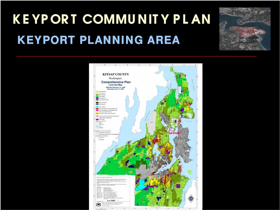
3 KEYPORT PLANNING AREA
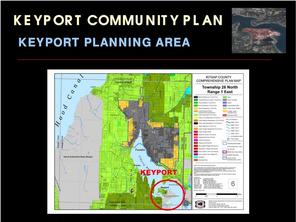
4 KEYPORT PLANNING AREA
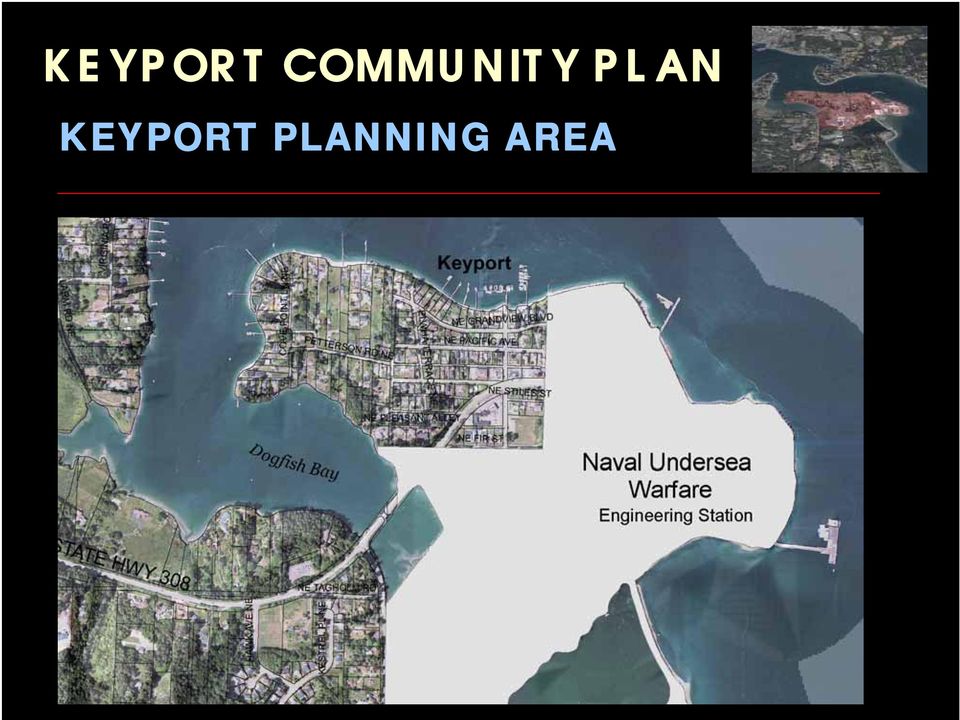
5 KEYPORT PLANNING AREA
6 COMMUNNITY PLAN CHAPTERS 1. Introduction 2. Land Use & Development 3. Transportation & Pedestrian Improvements 4. Public Facilities & Infrastructure 5. Port Improvements & Waterfront Development 6. Natural Environment / Parks & Recreation 7. Arts & Culture 8. Sustainability 9. Community Building / Plan Implementation 10. Glossary of Terms & References APPENDICES

7 CHAPTER 1: Introduction CHAPTER ELEMENTS: History of Keyport Purpose and Organization of Community Plan Public Participations & Keyport Online Survey Appendix A: Keyport Online Survey Results Keyport Vision Statement Limited Area of More Intense Rural Development (LAMIRD) LAMIRD Definition LAMIRD Boundary Alternatives Preferred LAMIRD Boundary
 LAMIRD Definition LAMIRD Boundary Alternatives Preferred LAMIRD")
8 KEYPORT VISION STATEMENT KEYPORT VISION STATEMENT Keyport is a rural, historic waterfront village bounded and limited in size by its natural borders of water and the Naval Undersea Warfare Center. The community consists primarily of single family homes, a few small businesses, and a community park system. The community is close-knit, where people know and greet their neighbors, and has an active community club which provides social events. The Keyport community wants to limit urban growth to retain its sense of community and small-town ambience. Keyport citizens would prefer that future business expansion would be limited to small businesses and services serving the community, consistent with historical usage located near the downtown core. The Keyport community desires to re-establish certain historic commercial zoning and to establish appropriate land use zoning to maintain historic rural character where it is consistent with historical public services. The community would like to establish development patterns, including lot sizes, which may encourage infill development consistent with the Growth Management Act. These infill development patterns would be consistent with historical progressive development, yet limit urban-like sprawl and high density growth. The Keyport community would like to improve existing transportation infrastructure and services to make it easier and safer to get around the community, make the community more pedestrian friendly, and improve parking for visitors. Improvements would be requested from Kitsap County as feasible to improve public infrastructure and facilities, including expansion of the sewer lines, upgrading the storm water drainage system, improving street lighting, and improving marine access. The community would like to retain a flexible community park system attractive as gathering and recreational centers for both children and adults. Keyport citizens would like to preserve and enhance the small-town atmosphere and visual character of the area for the community as well as visitors, where one can enjoy a safe and pleasurable walk, enjoy the spectacular marine and mountain views, and have easy access to a village center that acts as a social center with restaurants and services providing for basic needs.

9 LAMIRD DEFINITION Limited Area of More Intense Rural Development ( LAMIRD ): In order to determine what should be included in the Keyport Village, guidance was taken from the GMA, the Washington State Department of Community Trade and Economic Development and the Kitsap County Comprehensive Plan. Significant elements from these documents were utilized to develop general guidelines for determining the Keyport Village boundary as a Type 1 LAMIRD per RCW 36.70A.070 (5)(d)(i). These elements include: Identify residential parcels that were platted prior to July 1, 1990, according to chapter 36.70A RCW, particularly noting those at urban densities of less than 3 units/acre; Identify all commercial, industrial and community services platted prior to July 1, 1990; Identify existing structures; Identify the existing public services, ie, water and sewer; Address: (a) the need to preserve the character of existing natural neighborhoods and communities, (b) physical boundaries such as bodies of water, streets and highways, and land forms and contours, (c) the prevention of abnormally irregular boundaries, and (d) the ability to provide public facilities and public services in a manner that does not permit low-density sprawl; and Identify critical areas (ie, wetlands, areas of geological concern, frequently flooded areas, fish and wildlife conservation areas, critical aquifer recharge areas or wellhead protection zones and resource lands).

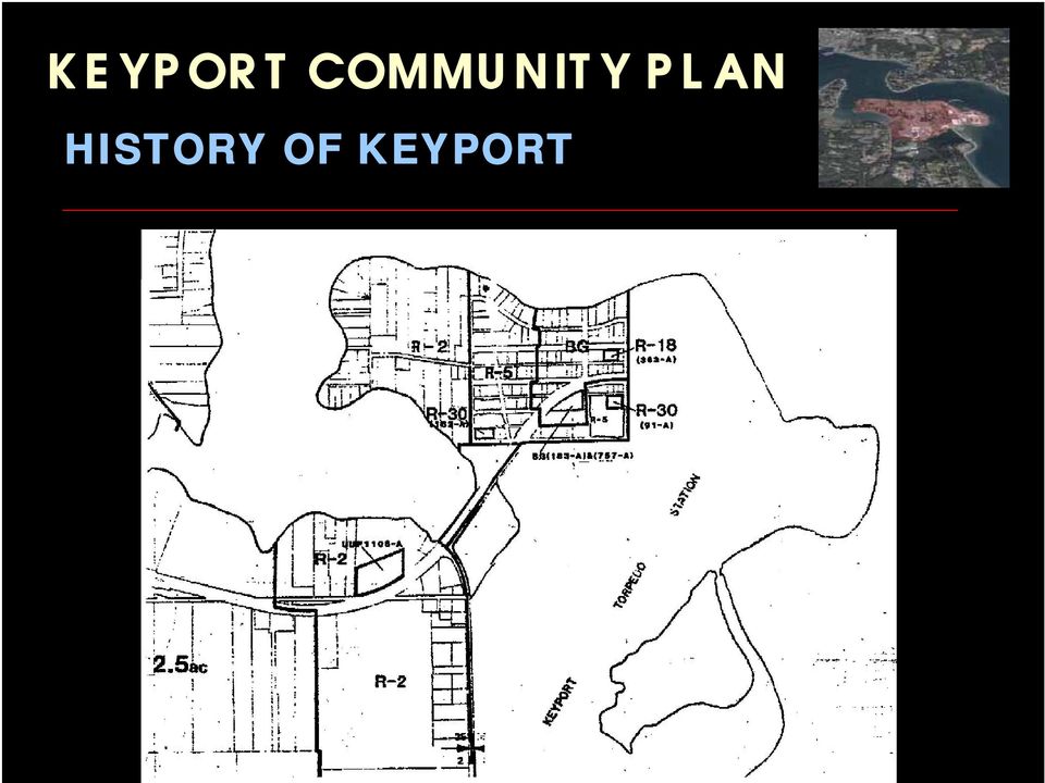
10 HISTORY OF KEYPORT

11 HISTORY OF KEYPORT
12 KEYPORT PRESENT ZONING

13 PROPOSED LAMIRD BOUNDARY

14 CHAPTER 2: Land Use & Economic Development CHAPTER ELEMENTS: Residential Land Use Housing Keyport Historic Buildings Commercial Land Use Economic Development View Protection

15 KEYPORT PROPOSED ZONING

16 KEYPORT PROPOSED ZONING Keyport Village Residential (KVR) Density 5 units / Acre (orange) Keyport Village Low Residential (KVLR) Density 2 units / Acre (yellow) Cluster Provision 3 Units / Acre Parks (green) Keyport Village Commercial (KVC) Density 5 units / Acre for Mixed-Use (blue) Neighborhood Commercial (NC) 1 Parcel Retains Historical Vested Density. (purple)
 Neighborhood Commercial (NC) 1 Parcel Retains Historical Vested Density.")
17 KEYPORT ECONOMIC DEVELOPMENT

18 CHAPTER 3: Transportation & Pedestrian Improvements CHAPTER ELEMENTS: Vehicular Transportation Transit Other Transportation Options Pedestrian Improvements & Non- Motorized Infrastructure & Services

19 CHAPTER 4: Public Facilities & Infrastructure CHAPTER ELEMENTS: Naval and other Federal Facilities Sewer & Wastewater Collection & Treatment Public Water Systems Storm Water Management Electrical & Natural Gas Fire, Emergency Services, & Law Enforcement Public Education & Library Services Solid Waste

20 KEYPORT SEWER LINES

21 KEYPORT WATER LINES
22 CHAPTER 5: Port Improvements & Waterfront Development CHAPTER ELEMENTS: Port of Keyport Keyport Marine Services Waterfront Development Shoreline Waterborne Spill & Incident Response Plans
23 KEYPORT SHORELINE DESIGNATIONS
24 CHAPTER 6: Natural Environment / Parks & Recreation CHAPTER ELEMENTS: Natural Environment Kitsap County Critical Areas Parks & Recreation Meeting Facilities
25 KEYPORT NATURAL ENVIORNMENT
26 CHAPTER 7: Arts & Culture CHAPTER ELEMENTS: Arts Promoting Artists, Galleries, & Art Studios in Keyport Public Art & Art Events Art Classes & Resident Artists. Culture Promoting a Farmer s Market in Keyport Musical Concerts Activities for Children.
27 CHAPTER 8: Sustainability CHAPTER ELEMENTS: Low Impact Development Promoting Low Impact Development for Storm Water Management Renewable Energy Promoting Solar, Wind, Tidal, & Wave Energy Generation Projects. Low Energy Lighting Promoting Low Energy Lighting for Port and Public Lighting Green Building Promoting Green Building / US Green Building Council LEED Standards.
28 CHAPTER 9: Community Building / Plan Implementation CHAPTER ELEMENTS: Keyport Community Building Ensure Community Involvement in land use and governmental activities Support of Keyport Improvement Group Implementation Promoting Completion of Key Projects. All Goals & Policies
29 KEYPORT KEY PROJECTS 1. WASHINGTON AVENUE - ECONOMIC DEVELOPMENT PROJECTS (Chapter 2) 2. MOSQUITO FLEET TRAIL SEGMENT COMPLETION (Chapter 3) 3. TRAFFIC CALMING FOR STATE ROUTE 308 / WASHINGTON AVENUE INTERSECTION (Chapter 3) 4. KEYPORT SEWER IMPROVEMENT DISTRICT (Chapter 4) 5. PORT OF KEYPORT MASTER PLAN UPDATE (Chapter 5) 6. KEYPORT SALTWATER PARK - PEDESTRIAN IMPROVEMENTS (Chapter 6) 7. KEYPORT CENTRAL PARK TDR PILOT PROJECT (Chapter 6) 8. KEYPORT PUBLIC ART PROPOSAL (MURAL, STATUE, KIOSK, ETC.) (Chapter 7) 9. PORT OF KEYPORT TIDAL ENERGY GENERATOR (Chapter 8) 10. KEYPORT IMPROVEMENT GROUP OFFICIAL DESIGNATION (Chapter 9)
30 CHAPTER 10: Glossary of Terms & References CHAPTER ELEMENTS: Glossary of Terms Definitions of Terms Used in Plan References Sources of Information for Data, Maps, & Photos
31 COMMUNNITY PLAN APPENDICIES A. Keyport Online Survey Results B. Amendments to Kitsap County Zoning Ordinance C. Keyport Historic Building Analysis D. Kitsap County Pedestrian / Bicycle Collision Data E. Mosquito Fleet Plan Keyport Excerpts F. View Protection G. Keyport Design Guidelines H. Zoning Maps & Keyport Land Use Capacity Analysis (KLUCA) I. Keyport Park Transfer of Development Rights
32 LAMIRD BOUNDARY ALTERNATIVES LAMIRD BOUNDARIES: TOTAL OF 6 ALTERNATIVES PROPOSED. 3 proposals include Keyport Trace Subdivision 2 proposals included entire Naval Base Keyport 2 proposals only include Naval Undersea Museum. Keyport Survey Results supported Alternative 1 Appendix A: Keyport Online Survey Results
33 LOT CLUSTERING PROPOSAL PROPOSAL ELEMENTS: Affects Keyport Village Residential Low (KVLR) zone only. Allows 3 units per acre under a Performance Based Development proposal. Proposal would allow minimum lot size of 12,500 Sq.ft. (21,780 Sq.ft. normally) Proposal would allow a total of 13 additional dwelling units. Appendix H: Keyport Land Use Capacity Analysis
34 APPENDIX F: VIEW PROTECTION ELEMENTS: Proposal would limit waterfront owners to maximum height of 28 feet. Survey Results supported view protection: 60 % Very Important (24 of 40) 28 % Somewhat Important (12 of 40) 12 % Not Important (5 of 40) Refer to Appendix A Voted not to be included in Keyport Community Plan. May 22, 2007 Keyport meeting 12 of 15 members present (80 %) voted for no view protection.
35 PLANNING COMMISSION TASKS Collect Public Comments on Draft Plan. Provide Clear Direction for: Preferred LAMIRD Boundary Lot Clustering Provision View Protection Recommendation to Board of County Commissioners.
36 PROJECT SCHEDULE Community Meeting tonight in Keyport to discuss draft plan. Public Hearing Scheduled for Tuesday Evening (6:30 PM) August 14 th, Deliberation & Recommendation Scheduled for August 28 th, Anticipated presentation to Board of County Commissioners in late September / Early October 2007.
37 QUESTIONS? QUESTIONS AND COMMENTS SHOULD BE DIRECTED TO: James Weaver, AICP Senior Planner Department of Community Development
2010 Salida Community Priorities Survey Summary Results
 SURVEY BACKGROUND The 2010 Salida Community Priorities Survey was distributed in September in an effort to obtain feedback about the level of support for various priorities identified in the draft Comprehensive
Corridor Goals and Objectives
 Corridor Goals and Objectives This chapter presents the goals and objectives, developed by the Corridor Study Committee, that serve as the purpose and intent of the Corridor Plan. This plan covers a twenty
Attachment B Policy Audit Template
 Attachment B Policy Audit Template 5 6 7 8 9 0 Provide A Variety of Transportation Choices Provide A Variety of Transportation Choices Provide A Variety of Transportation Choices Encourage transit-oriented
Land Use and Zoning. Land Use Within the Port Madison Indian Reservation
 Land Use and Zoning Land Use Within the Port Madison Indian Reservation A portion of the Suquamish Rural Village is Trust land, owned either by the Tribe or individual tribal members. The following list
Application No.: 14.074 Steve Rush, representing Rocky Mountain Power Rocky Mountain Power Project Location: approximately 1600 N. 6800 E.
 Planning Commission Staff Report Planning and Development Services Croydon Substation Conditional Use Permit Public Meeting August 28, 2014 Application No.: 14.074 Applicant: Steve Rush, representing Rocky
WESTFIELD-WASHINGTON ADVISORY PLAN COMMISSION December 7, 2015 1512-SPP-24 & 1512-ODP-24
 Petition Number: Subject Site Address: Petitioner: Request: East side of Oak Road, north of 151 st Street Langston Development Co. Primary Plat and Overall Development Plan amendment review for Mapleridge
Iowa Smart Planning. Legislative Guide March 2011
 Iowa Smart Planning Legislative Guide March 2011 Rebuild Iowa Office Wallace State Office Building 529 East 9 th St Des Moines, IA 50319 515-242-5004 www.rio.iowa.gov Iowa Smart Planning Legislation The
2015 -- H 6042 S T A T E O F R H O D E I S L A N D
 LC00 01 -- H 0 S T A T E O F R H O D E I S L A N D IN GENERAL ASSEMBLY JANUARY SESSION, A.D. 01 A N A C T RELATING TO TOWNS AND CITIES -- RHODE ISLAND COMPREHENSIVE PLANNING AND LAND USE ACT Introduced
VANDERBILT COMPARISON
 Village of Vanderbilt Comparison One County, One Vision Master Plan (2000) 1 15 Improve recreation in Otsego County by assessing the availability and need to improve bike paths, county recreation facilities,
Policy GRN-1.1.2. The City will adopt a Go Green Initiative to implement strategies to reduce greenhouse gas emissions within the City s borders.
 Vision Statement: Provide goals, objectives, and policies that preserve, improve, and promote responsible use and protect the City s natural and built environment. Goals, Objectives and Policies: Goal
FUTURE LAND USE ELEMENT
 GOALS, OBJECTIVES AND POLICIES FUTURE LAND USE ELEMENT GOAL A THE CITY OF FORT WALTON BEACH WILL PLAN FOR AND PROVIDE A HIGH QUALITY OF LIFE TO MEET THE NEEDS OF THE CURRENT AND FUTURE POPULATION, PROVIDING
Land Use Series. Check List # 1I For Adoption of an Amendment to a Plan. December 22, 2010. Bringing Knowledge to Life!
 Land Use Series Bringing Knowledge to Life! Thirty seven million acres is all the Michigan we will ever have. Former Governor William G. Milliken Michigan State University Extension Land Use Team http://ntweb11a.ais.msu.
Chapter 13: Implementation Plan
 Chapter 13: 13.1. INTRODUCTION The purpose of the implementation chapter of the Comprehensive Plan is to set forth the actions that the City will take to ensure that the plans, programs and policies set
INSTITUTIONAL MASTER PLAN NOTIFICATION FORM / PROJECT NOTIFICATION FORM BOSTON UNIVERSITY MEDICAL CENTER
 INSTITUTIONAL MASTER PLAN NOTIFICATION FORM / PROJECT NOTIFICATION FORM BOSTON UNIVERSITY MEDICAL CENTER JUNE 7, 2013 SUBMITTED TO: BOSTON REDEVELOPMENT AUTHORITY ONE CITY HALL SQUARE BOSTON, MA 02201
AGENDA LARIMER COUNTY PLANNING COMMISSION Wednesday, April 20, 2016/6:30 P.M./Commissioners' Hearing Room
 AGENDA LARIMER COUNTY PLANNING COMMISSION Wednesday, April 20, 2016/6:30 P.M./Commissioners' Hearing Room A. CALL TO ORDER B. PLEDGE OF ALLEGIANCE C. PUBLIC COMMENT ON THE COUNTY LAND USE CODE D. PUBLIC
Village of Spring Valley Comprehensive Plan 2009-2029
 Chapter 8: Intergovernmental Cooperation Introduction Intergovernmental communication, coordination, and cooperation can make a significant difference in the implementation and administration of a comprehensive
Conducting a Land Use Inventory
 Chapter 3 Conducting a Land Use Inventory Included in this chapter: Determining Current Land Use Conditions Preparing a Base Map Deciding on Land Use Categories Collecting Current Land Use Data Preparing
Rezoning case no. RZ15-08: Adam Development Properties, LP
 PLANNING AND ZONING COMMISSION STAFF REPORT June 4, 2015 Rezoning case no. RZ15-08: Adam Development Properties, LP CASE DESCRIPTION: LOCATION: a request to amend the development plan of a previously-approved
NOTICE OF PREPARATION
 PLANNING DIVISION CITY OF SUNNYVALE P.O. BOX 3707 SUNNYVALE, CA 94088-3707 NOTICE OF PREPARATION TO: Responsible, Trustee, and Other Interested Public Agencies FROM: Sunnyvale Community Development 456
Pend Oreille County, Washington. Comprehensive Plan
 Pend Oreille County, Washington Comprehensive Plan On Monday October 17 th, 2005 the Pend Oreille County Board of County Commissioners approved Resolution No. 2005-33 adopting the and Future Land Use Map.
Draft Goals and Objectives Wadena Comprehensive Plan City of Wadena, Minnesota. Land Use Goals:
 Draft Goals and Objectives Wadena Comprehensive Plan City of Wadena, Minnesota Land Use Goals: 1. Growth in Wadena will be undertaken in such a manner as to create a full range of living, working, shopping,
THE RUSKIN COMMUNITY PLAN
 THE RUSKIN COMMUNITY PLAN Introduction Ruskin is a historic community situated on the shores of Tampa Bay, the Little Manatee River and the Ruskin Inlet, approximately 16 miles southeast of Tampa. The
Restoration. a brief look at
 Copyright 2009 Canin Associates, Inc. All rights reserved. No part of this publication may be reproduced or transmitted by any means without written permission from Canin Associates, Inc. a brief look
CITY OF WEST PALM BEACH PLANNING BOARD Meeting Date: September 24, 2012 Planning Board Case No. 1248Q
 CITY OF WEST PALM BEACH PLANNING BOARD Meeting Date: September 24, 2012 Planning Board Case No. 1248Q Morse Life Major Planned Development Amendment Location Aerial I. REQUEST Morse Campus outlined in
CITY OF GREEN COVE SPRINGS COMPREHENSIVE PLAN 2025
 CITY OF GREEN COVE SPRINGS COMPREHENSIVE PLAN 2025 Adopted August 2, 2011 CITY OF GREEN COVE SPRINGS COMPREHENSIVE PLAN 2025 ADOPTED 8/2/2011 TABLE OF CONTENTS Future Land Use Element... 1 Transportation
THREE MILE PLAN/URBAN GROWTH BOUNDARY INTERGOVERNMENTAL AGREEMENT
 THREE MILE PLAN/URBAN GROWTH BOUNDARY INTERGOVERNMENTAL AGREEMENT THIS INTERGOVERNMENTAL AGREEMENT, entered into by and between the BOARD OF COUNTY COMMISSIONERS OF THE COUNTY OF GUNNISON, COLORADO, a
Chapter 7 ZONING PLAN
 Chapter 7 ZONING PLAN Introduction This Chapter opens with a general description of a zoning plan. It is followed by a brief explanation of the relationship between this Growth Management Plan and the
Los Angeles Union Station, CA Sustainable Neighborhood Assessment. April 22-23, 2014
 Los Angeles Union Station, CA Sustainable Neighborhood Assessment April 22-23, 2014 Sustainable Neighborhood Assessment Through the Sustainable Neighborhood Assessment Tool developed by Global future development
The Metropolitan Planning Commission. DATE: May 19, 2015
 TO: FROM: The Metropolitan Planning Commission MPC Staff DATE: May 19, 2015 SUBJECT: Petition of LLC, Owner Harold Yellin, Agent PIN: 2-0015-01-002 & 003 Lot Size:.85 Acres (approximately) Aldermanic District:
CITY COUNCIL / PLANNING COMMISSION JOINT STUDY SESSION AGENDA REPORT
 CITY COUNCIL / PLANNING COMMISSION JOINT STUDY SESSION AGENDA REPORT MEETING DATE: SEPTEMBER 8, 2015 ITEM NUMBER: 1 SUBJECT: PROPOSED GENERAL PLAN LAND USE ALTERNATIVE FOR THE YEAR 2015-2025 GENERAL PLAN
Kendell Keith, RLA, AICP, LEED AP Executive Vice President RELEVANT EXPERIENCE
 EDUCATION Master of Business Administration, Rollins College, Winter Park, Florida (2006) Master of City Planning, Georgia Institute of Technology, Atlanta, Georgia (1991) Graduate Certificate in Real
TABLE OF CONTENTS. INTRODUCTION...1 Purpose of a Comprehensive Plan...1 McKenzie County Comprehensive Plan...1 Definitions...2 Goal...2 Vision...
 MCKENZIE COUNTY COMPREHENSIVE PLAN TABLE OF CONTENTS INTRODUCTION...1 Purpose of a Comprehensive Plan...1 McKenzie County Comprehensive Plan...1 Definitions...2 Goal....2 Vision...3 ECONOMIC DEVELOPMENT...4
INTRODUCTION TO ZONING DISTRICT REGULATIONS
 INTRODUCTION TO ZONING DISTRICT REGULATIONS Classification of Zoning Districts Zoning districts in Dorchester County are categorized as Suburban Urban, Suburban Transition, or Rural. These districts are
Capital Facilities Planning Guidebook. Comprehensive Planning under the Growth Management Act
 Capital Facilities Planning Guidebook Comprehensive Planning under the Growth Management Act Capital Facilities Guidebook PUBLICATION SUMMARY Title: Capital Facilities Planning Guidebook: Comprehensive
FILE NO.: Z-6915-C. Gamble Road Short-form PCD and Land Alteration Variance Request
 FILE NO.: Z-6915-C NAME: Gamble Road Short-form PCD and Land Alteration Variance Request LOCATION: Located on the Northwest corner of Chenal Parkway and Gamble Road DEVELOPER: Davis Properties P.O. Box
Public Participation Plan. June 2014
 Public Participation Plan June 2014 The City of Bellingham is in the process of updating its 2006 Comprehensive Plan as required by the State Growth Management Act (GMA). The new plan will provide a 20
Public Survey for Phase I
 Rockfish Valley Area Plan: Public Survey for Phase I For Nelson County Residents & Property Owners Name: OPTIONAL: Location of residence or property: o Address: o Voting District: North Central West South
2013 2015 COMPREHENSIVE PLAN UPDATE CITY COUNCIL ADOPTION DECEMBER 8, 2015
 2013 2015 COMPREHENSIVE PLAN UPDATE CITY COUNCIL ADOPTION DECEMBER 8, 2015 COMPREHENSIVE PLAN UPDATE OVERVIEW Deliberate and make a motion after each ordinance discussion in this order: 1. Ordinance O-4506:
Rapid City Downtown Area Master Plan. Draft Plan Concepts April 2016
 Rapid City Downtown Area Master Plan Draft Plan Concepts April 2016 CALL TO ACTION! A Thriving Downtown = Regional Economic Prosperity Rapid City is competing nationally for a limited supply of young skilled
Draft ARTICLE 20A "AO" ANTIETAM OVERLAY DISTRICT
 Draft ARTICLE 20A "AO" ANTIETAM OVERLAY DISTRICT Section 20A.0 Purpose The purpose of the Antietam Overlay District is to provide mechanisms for the protection of significant historic structures and land
Frederick. Frederick. Maryland. Smart Growth Successes. Frederick. Maryland Department of Planning
 Frederick Frederick Maryland Smart Growth Successes Frederick Maryland Department of Planning Smart, Green & Growing Martin O Malley Governor Anthony G. Brown Lt. Governor Maryland Department of Planning
City of North Miami Beach, Florida Planning and Zoning Department
 City of North Miami Beach, Florida Planning and Zoning Department City Council Staff Report TO: FROM: City Council Carlos Rivero, City Planner DATE: March 17, 2015 ITEM: 14-021B (Ordinance no. 2015-5)
COUNTY OF ALBEMARLE PLANNING STAFF REPORT SUMMARY. Staff: Claudette Grant
 COUNTY OF ALBEMARLE PLANNING STAFF REPORT SUMMARY Project Name: ZMA 2013-00004 Hollymead Town Center Block VI Planning Commission Public Hearing: July 29, 2014 Staff: Claudette Grant Board of Supervisors
1 2 3 4 Appendix A Appendix B Appendix C
 1 2 3 4 Appendix A Appendix B Appendix C Introduction This chapter provides the foundation for the Comprehensive Plan, outlining why we plan, the planning process, Smart Growth Planning, and the planning
Comprehensive Plan Committee Kick-off Meeting A G E N D A
 Comprehensive Plan Committee Kick-off Meeting A G E N D A Monday, June 1, 2015, 5:30-7:00 PM 530 Evans Street Sheppard Memorial Library, Room A Greenville, NC 27858 1. Welcome and introductions Merrill
NYCIDA PROJECT COST/BENEFIT ANALYSIS June 5, 2014
 NYCIDA PROJECT COST/BENEFIT ANALYSIS June 5, 2014 APPLICANT Skyline Restoration Inc. CGI Northeast, Inc. Spring Scaffolding LLC Metropolitan Northeast LLC 11-20 37 th Avenue Long Island City, NY 11101
Citizen Advisory Group Meeting #1 December 8, 2011 6:00 p.m.
 Citizen Advisory Group Meeting #1 December 8, 2011 6:00 p.m. Meeting Agenda 1. Background Information 2. Policy Framework 3. Plan Development Process 4. Public Input Results 5. Vision Statement 6. Group
TOWN OF CARY CONDITIONAL USE ZONING PERMIT. 412 Rutherglen Cary, NC 27511-6437. 412 Rutherglen Cary, NC 27511-6437
 TOWN OF CARY CONDITIONAL USE ZONING PERMIT PETITION: PETITIONER(S): OWNER(S): LOCATION: 01-REZ-16 204 N. Dixon Avenue, Cary, NC PARCEL IDENTIFICATION: 076418218784 REALID: 0031004 AREA: APPROVED ZONING:
Camden Community Conversation. Vibrancy Survey Results May 21, 2009
 Camden Community Conversation Vibrancy Survey Results May 21, 2009 Prepared by Friends of Midcoast Maine For the Citizens of Camden Electronic survey and analysis by Jane Lafleur and Deborah Dodge. May
Envision Venice Strategic Plan for Fiscal Year Ending. September 30, 2016. Preserving and Enhancing the Venice Quality of Life.
 Adopted April 28, 2015 October 1, 2015 through September 30, 2016 Envision Venice Strategic Plan for Fiscal Year Ending September 30, 2016 Preserving and Enhancing the Venice Quality of Life Table of Contents
 INTRODUCTION As part of a statewide realignment of due dates for updating local comprehensive plans, the Georgia Department of Community Affairs (DCA) is requiring partial updates as an interim step for
STRATEGIC PLAN 2015 2020 2030
 STRATEGIC PLAN 2015 2020 2030 Boca Raton, Florida May 2015 Lyle Sumek Associates, Inc. Phone: (386) 246-6250 9 Flagship Court Fax: (386) 246-6252 Palm Coast, FL 32137 E-mail: [email protected] Table
Model Subdivision and Land Development (SALDO) Subdivision/ Land Development Presentation Overview. Why Subdivision and Land Development Regulations?
 Subdivision/ Land Development Presentation Overview. Why Subdivision and Land Development Regulations?") Model Subdivision and Land Development (SALDO) Subdivision/ Land Development Presentation Overview Purpose of Subdivision/ Land Development Ordinances (SALDO) Municipalities Planning Code Process Design
Model Subdivision and Land Development (SALDO) Subdivision/ Land Development Presentation Overview Purpose of Subdivision/ Land Development Ordinances (SALDO) Municipalities Planning Code Process Design
Capital Facilities Financial Plan (2007-2012) Supporting document to the 20-year Comprehensive Management Plan
 Supporting document to the 20-year Comprehensive Management Plan") Capital Facilities Financial Plan (2007-2012) Supporting document to the 20-year Comprehensive Management Plan Revised May 2007 CAPITAL FACILITIES FINANCIAL PLAN 2007-2012 CLARK COUNTY 20-YEAR GROWTH MANAGEMENT
Capital Facilities Financial Plan (2007-2012) Supporting document to the 20-year Comprehensive Management Plan Revised May 2007 CAPITAL FACILITIES FINANCIAL PLAN 2007-2012 CLARK COUNTY 20-YEAR GROWTH MANAGEMENT
ALACHUA COUNTY COMPREHENSIVE PLAN 2011-2030
 ALACHUA COUNTY COMPREHENSIVE PLAN 2011-2030 Adopted April 5, 2011 (Ordinance 11-01, Effective July 22, 2011; Housing Element effective August 23, 2011) Updated through January 21, 2016 Alachua County Growth
Technical Memorandum No. 1: Environmental Approach and Decision Making Criteria
 Memorandum TO: FROM: Michael Bergstrom and Robin Cole City of Bellevue Nancy Bird, AICP EDAW, Inc. DATE: July 23, 2008 RE: Technical Memorandum No. 1: Environmental Approach and Decision Making Criteria
City of Valdosta Land Development Regulations. Table of Contents
 TITLE 1 ADMINISTRATION Chapter 102 General Provisions 102-1 Title 102-2 Purpose 102-3 Authority 102-4 Jurisdiction 102-5 Application of Ordinance 102-6 Relationship to Existing Ordinances 102-7 Powers
Volume II Recommendations January 2006 City of Madison Comprehensive Plan
 2 LAND USE THE PLAN: GOALS, OBJECTIVES, POLICIES AND IMPLEMENTATION RECOMMENDATIONS Volume II Recommendations January 2006 TABLE OF CONTENTS Land Use Overview...2 1 Summary of Land Use Issues...2 2 Accommodating
How to do a Comprehensive Plan Part 1-1. Purdue Land Use Team Christine E. Nolan, Chair
 How to do a Comprehensive Plan Part 1-1 June 16 th, 2005 A Presentation by Purdue Land Use Team Christine E. Nolan, Chair Source: APA Why Plan? In today s world of fast-paced change, footloose companies,
Appendix D: 2015 Program & Service Budget
 Appendix D: 2015 Program & Service Budget Program & Service Budget by Program.. 1 Program & Service Budget by Sub-Program....... 2 Program & Service Budget by Service.... 3 Program & Service Budget by
Comprehensive Plan Policies that support Infill and Mixed Use
 Comprehensive Plan Policies that support Infill and Mixed Use Introduction A comprehensive plan provides a broad vision for the future growth of a community. It is often formulated using community visioning
Case Study: Imagine Austin Comprehensive Plan. David Rouse, AICP - Principal, WRT [email protected]
 Case Study: Imagine Austin Comprehensive Plan David Rouse, AICP - Principal, WRT [email protected] Imagine Austin Study Area City Council s Goals for the Plan Community Engagement Values-Driven Planning
PUBLIC SCHOOL FACILITIES ELEMENT
 PUBLIC SCHOOL FACILITIES ELEMENT GOALS, OBJECTIVES AND POLICIES JULY 2006 Prepared By: The City of Miami Gardens Planning and Zoning Department 1515 NW 167 th Street, Building 5, Suite 200 Miami Gardens,
MEMORANDUM OF AGREEMENT Between THE CITY OF BALTIMORE And THE MID-ATLANTIC FEDERAL PARTNERSHIP FOR THE ENVIRONMENT
 MEMORANDUM OF AGREEMENT Between THE CITY OF BALTIMORE And THE MID-ATLANTIC FEDERAL PARTNERSHIP FOR THE ENVIRONMENT The Mid-Atlantic Federal Partnership for the Environment ( MAFPE ) and the City of Baltimore
How To Amend A Stormwater Ordinance
 Regulatory Alternatives to Address Stormwater Management and Flooding in the Marlboro Street Study Area Alternative 1: Amend Existing Local Regulations This proposed alternative provides an incremental
Summary Community Workshop #2 Fruitvale San Antonio Senior Center. Wednesday, April 22, 2009 7:00-9:00 p.m.
 Summary Community Workshop #2 Wednesday, April 22, 2009 7:00-9:00 p.m. Workshop Format and Process The City of Oakland is preparing a Specific Plan that will help define and determine a common vision for
Gunnison County, CO Community Livability Report
 Gunnison County, CO Community Livability Report 2015 2955 Valmont Road Suite 300 777 North Capitol Street NE Suite 500 Boulder, Colorado 80301 Washington, DC 20002 n-r-c.com 303-444-7863 icma.org 800-745-8780
DOWNTOWN AND NEIGHBORHOODS
 DEVELOPMENT DOWNTOWN AND NEIGHBORHOODS There is no doubt that our Downtown is the heart of Litchfield County. It is vital that we begin to restore and renew the vibrancy of Torrington s center. The City
OFFICIAL PLAN REVIEW ENVIRONMENTAL STAKEHOLDERS FEEDBACK REPORT
 OFFICIAL PLAN REVIEW ENVIRONMENTAL STAKEHOLDERS FEEDBACK REPORT TABLE OF CONTENTS 1. ABOUT THE WORKSHOP Page 3 2. GREEN SPACE/OPEN SPACE AS A COMMUNITY CONNECTOR Page 5 3. SUSTAINABLE COMMUNITY DESIGN
REPORT OF THE PLANNING AND DEVELOPMENT DEPARTMENT FOR APPLICATION FOR REZONING ORDINANCE 2015-0183 TO PLANNED UNIT DEVELOPMENT APRIL 9, 2015
 AWH REPORT OF THE PLANNING AND DEVELOPMENT DEPARTMENT FOR APPLICATION FOR REZONING ORDINANCE 2015-0183 TO PLANNED UNIT DEVELOPMENT APRIL 9, 2015 The Planning and Development Department hereby forwards
City of North Liberty, Iowa Comprehensive Plan
 City of North Liberty, Iowa Approved November 2013 2013 North Liberty Acknowledgments Table of Contents Page Introduction 2 Where We re at Today ning 3 Current Land Use 3 Population Estimates 4 Significant
DRAFT POLICIES COUNTY OF HALIBURTON OFFICIAL PLAN UPDATE
 SETTLEMENT AREAS Introduction Urban Serviced DRAFT POLICIES These urban areas have either full or partial primary urban services, mainly water, sewage and roads. Functionally, they tend to service larger
PINELLAS COUNTY COMPREHENSIVE PLAN
 PINELLAS COUNTY COMPREHENSIVE PLAN Future Land Use Map (FLUM) Category Descriptions and Rules Amended March 17, 2009 (Ordinance 09-17) Amended March 16, 2010 (Ordinance 10-18) Amended October 26, 2010
Development impact fees can also create a strong financial incentive to discourage inefficient land development patterns by:
 Development Impact Fees What is it? New development creates a demand for additional schools, roads, sewer lines, and recreational facilities. Development impact fees are one-time fees charged to new development
CITY OF WEST PALM BEACH PLANNING BOARD Meeting Date: August 20, 2013 Planning Board Case No. 1564C
 CITY OF WEST PALM BEACH PLANNING BOARD Meeting Date: August 20, 2013 Planning Board Case No. 1564C Rezoning from Community Service (CS) to Community Service Planned Development (CSPD) Hanley Center 5200
CITY OF WINTER GARDEN
 CITY OF WINTER GARDEN CITY COMMISSION REGULAR MEETING MINUTES A REGULAR MEETING of the Winter Garden City Commission was called to order by Mayor Rees at 6:30 p.m. at City Hall, 300 West Plant Street,
Downtown South Salt Lake Redevelopment City of South Salt Lake
 Project Information LOCAL PLANNING RESOURCE PROGRAM 2015 Downtown South Salt Lake Redevelopment City of South Salt Lake Overview of Objectives: Building a downtown city center could be the most significant
administrative subdivisions of the counties and are not counted as separate governments in census statistics on governments. IOWA
 IOWA Iowa ranks 17th among the states in number of local governments with 1,954 as of October 2007. COUNTY GOVERNMENTS (99) There are no areas in Iowa lacking county government. The county governing body
Electronic Signature and Fee Payment Confirmation
 Jeff Levine, AICP, Director Planning & Urban Development Department Electronic Signature and Fee Payment Confirmation Notice: Your electronic signature is considered a legal signature per state law. By
Zoning Districts, Gwinnett County, Georgia
 Zoning Districts, Gwinnett County, Georgia The zoning district descriptions in this section should be used as a guide only for the unincorporated areas of Gwinnett County. Before buying or selling property,
Town of Montezuma, New York Community Survey 2015
 Town of Montezuma, New York Community Survey 2015 The Montezuma Comprehensive Planning Committee and the Central New York Regional Planning & Development Board MONTEZUMA, NEW YORK COMMUNITY SURVEY PLEASE
Cannon Beach Comprehensive Plan CODIFIED With Amendments through June 2013 (Through Ordinance 13-01)
") Cannon Beach Comprehensive Plan CODIFIED With Amendments through June 2013 (Through Ordinance 13-01) City of Cannon Beach, PO Box 368, OR 97110 Telephone: 503-436-1581 Fax: 503-436-2050 Website: http://www.ci.cannon-beach.or.us
Cannon Beach Comprehensive Plan CODIFIED With Amendments through June 2013 (Through Ordinance 13-01) City of Cannon Beach, PO Box 368, OR 97110 Telephone: 503-436-1581 Fax: 503-436-2050 Website: http://www.ci.cannon-beach.or.us