THREDDS. THematic Real-time Environmental Distributed Data Services. Connecting people, documents and data
|
|
|
- Zoe Harrell
- 8 years ago
- Views:
Transcription
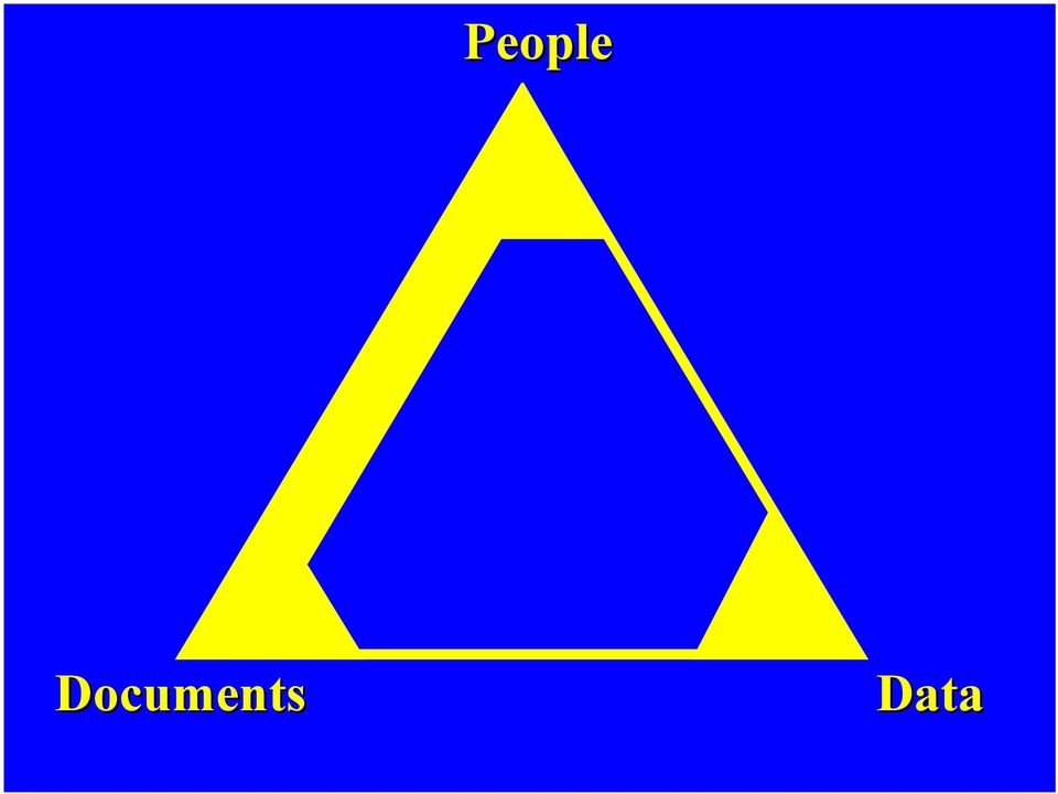
1 THREDDS THematic Real-time Environmental Distributed Data Services Connecting people, documents and data Ben Domenico, John Caron, Ethan Davis, Robb Kambic, Stefano Nativi Unidata Program Center and University of Florence March 2003 People Sponsored by NSF Documents Data 1

2 THREDDS Overview National Science Digital Library (NSDL) collections project Integrating real-time environmental data into Online educational materials Digital libraries (DLESE, NSDL) Two-year grant from NSF Department of Undergraduate Education (DUE) Led by Unidata Program Center (UPC) 2
 Led by Unidata Program")
3 THREDDS Partners: Data Providers University of Alabama Huntsville (Sara Graves, Rahul Ramachandran, Steve Tanner, Ken Keiser) ARM (Atmospheric Radiation Measurement, Chris Klaus) CDC, the Climate Diagnostic Center (Roland Schweitzer) COLA, Center for Oceans Land Atmosphere (Joe Wielgosz) University of Florence (Stefano Nativi) GMU, George Mason University (Menas Kafatos and Ruixin Yang) IRI/LDEO, International Research Institute/Lamont Doherty Earth Observatory (Benno Blumenthal) ESG, the Earth System GRID (Luca Cinquini, NCAR/SCD) IRIS DMC, Incorporated Research Institutes for Seismology Data Management Center (Rob Casey) NCAR, the National Center for Atmospheric Research (Don Middleton) NCDC, the National Climatic Data Center (Ben Watkins) NGDC, National Geophysical Data Center (Ted Habermann) NOMADS,NOAA Operational Model Archive and Distribution System, (Glenn Rutledge, NCDC) University of Oklahoma (Kelvin Droegemeier) PMEL, the Pacific Marine Environment Laboratory (Steve Hankin) FNMOC, Fleet Numerical Meteorological and Oceanographic Center (Phil Sharfstein) SSEC, the Space Science and Engineering Center., U. of Wisconsin-Madison (Steve Ackerman, Tom Whittaker) Unidata Community ADDE servers (Tom Yoksas, Unidata Program Center) 3
 NCAR, the National Center for Atmospheric Research (Don Middleton) NCDC, the National Climatic Data Center (Ben Watkins) NGDC, National Geophysical Data")
4 THREDDS Partners: Analysis/Display Tool Builders Data Discovery Toolkit and Foundry based on EDMI (Earth Data Multimedia Instrument, New Media Studio, Bruce Caron). GDS, GrADS/DODS Server (COLA, Center for Oceans Land Atmosphere, Joe Wielgosz) IDV, Integrated Data Viewer (Unidata Program Center, Don Murray) INGRID (IRI/LDEO, International Research Institute/Lamont Doherty Earth Observatory, Benno Blumenthal) LAS, Live Access Server (PMEL, the Pacific Marine Environment Laboratory, Steve Hankin) VGEE, Virtual Geophysical Exploration Environment (NCAR, DLESE, U. of Illinois, Unidata, many collaborators) WXWISE Applets (SSEC, the Space Science and Engineering Center., U. of Wisconsin-Madison, Tom Whittaker) 4
 WXWISE Applets (SSEC, the Space Science and Engineering Center., U. of Wisconsin-Madison, Tom Whittaker) 4")
5 THREDDS Partners: Interoperability ADDE, Abstract Data Distribution Environment (University of Wisconsin Madison, Tom Yoksas) DIMES, DIstributed MEtadata System (George Mason University, Ruixin Yang) DODS/OPeNDAP/Aggregation Server, Distributed Oceanographic Data System/Open source Project for a Network Data Access Protocol (University of Rhode Island, Unidata, Ethan Davis) DLESE, Digital Library for Earth System Education (Rajul Pandya) ESML, Earth System Markup Language (University of Alabama-Huntsville, Rahul Ramachandran) NCML, netcdf Markup Language (Earth System Grid/Unidata) ESRI, Environmental Science Research Institute (various) GCMD, Global Change Master Directory (Gene Major) OGC and ISO Standards (University of Florence, Stefano Nativi) 5
 ESRI, Environmental Science Research Institute (various) GCMD, Global Change Master Directory (Gene Major) OGC and ISO Standards (University of Florence, Stefano")
6 Unidata s Contributions A large, (inter)national, active, cooperative user community Coordination of many disparate contributors (universities, government agencies, digital libraries, commercial vendors, standards bodies ) Reliable, automated, real-time data systems Platform-independent 5D visualization with HTML document integration Basic inventory catalog generator and server software Client-side catalog access modules 6

7 Funding Sources Unidata 2003/2008 (NSF Atmospheric Science Division) THREDDS NSDL Collections Grant (NSF Department of Undergraduate Education) DODS/OPeNDAP (University of Rhode Island subcontract on Naval Ocean Partnership Program Grant) NWS/COMET Case Studies (NOAA NWS) 7
 NWS/COMET Case Studies (NOAA")
8 People Documents Data
9 People Documents: The Web Well-developed connections Document references Embedded multimedia Embedded interactive applets Powerful tools Google Dreamweaver Web-site management tools Web services 9

10 People Discovery and Publication Tools Discovery and Publication Services Documents Data

11 People Data Ad Hoc Tools/Services Traditional Unidata approach IDD moves data to local network McIDAS, GEMPAK, IDV (thick clients) Most analysis work done on local client Web-based data interactions Simple (passive) gif images LAS, INGRID, GDS (thin clients) Most analysis work done on remote server Combinations Web browse/catalogs with FTP delivery/local analysis Client/server (DODS/OPeNDAP, ADDE ) Embedded data access applets (WXWISE) All lack sophisticated, text-based Web search/discovery tools and coherent integration 11
 Embedded data access applets (WXWISE) All lack sophisticated, text-based Web search/discovery tools and coherent integration")
12 People Discovery and Publication Tools Analysis and Visualization Tools Discovery and Publication Services Data Services Documents Data 12

13 Documents Data Connect Words and Datasets THREDDS primary focus Associate words of the science with available datasets Create compound documents pointing to datasets Connect analysis tools to documents and datasets Wide range of compound documents Lists of datasets available on server with brief description of dataset classes Online publications pointing to datasets illustrating concepts Massive arsenal of Web and Digital Library search/discovery tools can be applied to compound documents 13

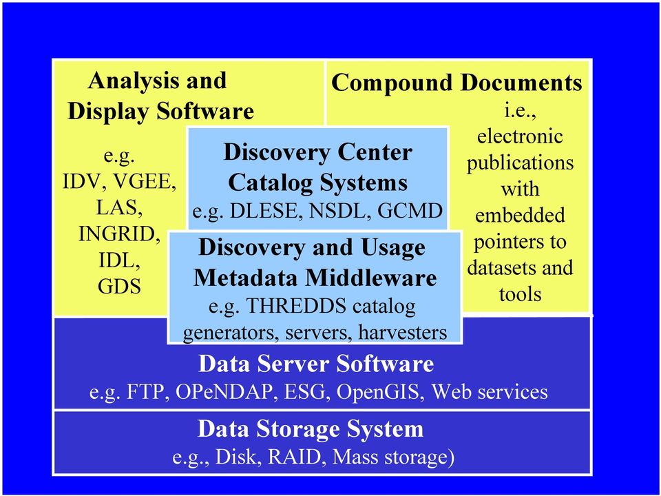
14 Analysis and Display Software e.g. IDV, VGEE, LAS, INGRID, IDL, GDS Discovery Center Catalog Systems e.g. DLESE, NSDL, GCMD Discovery and Usage Metadata Middleware e.g. THREDDS catalog generators, servers, harvesters Compound Documents i.e., Data Server Software e.g. FTP, OPeNDAP, ESG, OpenGIS, Web services Data Storage System e.g., Disk, RAID, Mass storage) electronic publications with embedded pointers to datasets and tools
15 Basic THREDDS InventoryCatalog Inventory list of datasets on server Generated automatically with minimal human input Viewed from within analysis and display application Can be harvested for inclusion in GCMD, DLESE, NSDL

16 People Discovery and Publication Tools Analysis and Visualization Tools Discovery and Publication Services Data Services Documents Catalog Generation Tools Data Catalog Services Data

17 People Discovery and Publication Tools Analysis and Visualization Tools Discovery and Publication Services THREDDS Middleware Data Services Documents Catalog Generation Tools Data Catalog Services Data

18 Remote Catalog Query and Data Access via Local Analysis Tool People Discovery and Publication Tools Analysis and Visualization Tools User accesses remote catalog via local analysis tool Discovery and Publication Services THREDDS Middleware User accesses remote dataset via local analysis tool Data Services Documents Catalog Generation Tools Data Catalog Services Data

19 Online Publication Viewed from Discovery at DLESE, module at DPC, VGEE tool at Unidata, datasets at NCAR Lends itself well to Web discovery tools, DL integration Can be: education module online scientific publication within Analysis Tool

20 Browser-base Thin Client Access LDEO/IRI web site publishes catalog of datasets available on server at UCAR Catalog resides and is updated at UCAR Browsing of datasets on UCAR server from LDEO server Also enables analysis and display of datasets on UCAR server using tools on LDEO server 20

21 Discovery in DLESE 21
22 Stepwise creation of third-party enhanced catalogs/case studies Begin with basic inventory catalog Crawler traverses datasets listed in basic catalog and adds location bounding box to location-enhanced catalog Gazetteer service examines location-enhanced catalogs to create a catalog of datasets associated with named region on Earth Evolve to event gazetteer with 5-dimensional bounding box (e.g., model output datasets related to Storm of the Century with vorticity above a threshold a distributed case study) 22
23 Enhanced Digital Library Catalogs Catalog System IDD Data Catalog Harvesting NcML or ESML Generator Model output Weather Obs IDD IDD Inventory Catalog Generator Event Gazetteer Enhanced THREDDS Inventory THREDDS Catalog and and Data Data Server Server Case Study Catalog Enhanced Catalogs Third Party THREDDS Third Party Catalog THREDDS Third Server Party Catalog THREDDS Server Catalog Server Data Mining Engine 23
24 Enhanced (via ESG) Metadata Catalog 24
25 ISCCP Collection Metadata 25
26 More ISCCP Metadata 26
27 Next Steps Bring catalog servers online at remaining data provider sites Complete work on client side catalog access modules Incorporate THREDDS modules into additional clients Add enhanced catalog capabilities Complete work to make catalogs compatible with DLESE catalog entries Add server components to enable DL harvesting of catalogs Work with DLESE to create sample educational modules with embedded data and tool pointers 27
28 Next Phase Participate in DLESE Data Services workshops: Technical sessions Educational module developers End users: professors, teachers, students Work with education partners to develop more educational materials with embedded data and tools Work with current THREDDS collaborators on tools for creating enhanced catalogs/virtual case studies Incorporate GIS (Geographic Information System) datasets into collections Develop new partnerships for integrating GIS data and tools into educational modules Work with OGC (Open GIS Consortium) protocols with focus on Web Coverage Service (WCS) Incorporate MyWorld GIS client into THREDDS Integrate THREDDS with evolving GRID technology 28
29 Funding Opportunities Unidata 2008 proposal to NSF/ATM: Distributed, organized collections of digital material DLESE Data Services NASA REASON CAN (2) include OPeNDAP support resources LEAD Large ITR proposal includes resources for IDV, THREDDS, LDM development NSDL Collections: follow on proposal due April 21 29
30 More Information 30
The Arctic Observing Network and its Data Management Challenges Florence Fetterer (NSIDC/CIRES/CU), James A. Moore (NCAR/EOL), and the CADIS team
, James A. Moore (NCAR/EOL), and the CADIS team") The Arctic Observing Network and its Data Management Challenges Florence Fetterer (NSIDC/CIRES/CU), James A. Moore (NCAR/EOL), and the CADIS team Photo courtesy Andrew Mahoney NSF Vision What is AON? a
The Arctic Observing Network and its Data Management Challenges Florence Fetterer (NSIDC/CIRES/CU), James A. Moore (NCAR/EOL), and the CADIS team Photo courtesy Andrew Mahoney NSF Vision What is AON? a
13.2 THE INTEGRATED DATA VIEWER A WEB-ENABLED APPLICATION FOR SCIENTIFIC ANALYSIS AND VISUALIZATION
 13.2 THE INTEGRATED DATA VIEWER A WEB-ENABLED APPLICATION FOR SCIENTIFIC ANALYSIS AND VISUALIZATION Don Murray*, Jeff McWhirter, Stuart Wier, Steve Emmerson Unidata Program Center, Boulder, Colorado 1.
The THREDDS Data Repository: for Long Term Data Storage and Access
 8B.7 The THREDDS Data Repository: for Long Term Data Storage and Access Anne Wilson, Thomas Baltzer, John Caron Unidata Program Center, UCAR, Boulder, CO 1 INTRODUCTION In order to better manage ever increasing
Real-time and Archived Antarctic. Interactive Processing Tools
 Real-time and Archived Antarctic Meteorological Data via a Synergy of Interactive Processing Tools Mark W. Seefeldt Department of Atmospheric and Oceanic Sciences University it of Colorado at Boulder,
PART 1. Representations of atmospheric phenomena
 PART 1 Representations of atmospheric phenomena Atmospheric data meet all of the criteria for big data : they are large (high volume), generated or captured frequently (high velocity), and represent a
Advancement of the NOMADS for Observational Data and Model Intercomparisons and the Establishment of a NCDC NOMADS Team and HelpDesk
 Advancement of the NOMADS for Observational Data and Model Intercomparisons and the Establishment of a NCDC NOMADS Team and HelpDesk A NOMADS Collaboration White Paper 5/5/2003 This white paper is intended
 Integrated Data Viewer (IDV) a visualization framework Yuan Ho Unidata Program Center Boulder, CO Presentation Outline Integrated Data Viewer (IDV) overview The IDV features IDV examples and customized
Development and Support for the USGODAE Server
 Development and Support for the USGODAE Server Mr. Mike Clancy Fleet Numerical Meteorology and Oceanography Center 7 Grace Hopper Ave, Stop 1 Monterey, CA 93943-5501 phone: (831) 656-4414 fax: (831) 656-4489
Environmental Data Management:
 Environmental Data Management: Challenges & Opportunities Mohan Ramamurthy, Unidata University Corporation for Atmospheric Research Boulder CO 25 May 2010 Environmental Data Management Workshop Silver
SCOOP Data Management: A Standards-based Distributed System for Coastal Data and Modeling
 SCOOP Data Management: A Standards-based Distributed System for Coastal Data and Modeling Helen Conover, Bruce Beaumont, Marilyn Drewry, Sara Graves, Ken Keiser, Manil Maskey, Matt Smith The University
GIS Initiative: Developing an atmospheric data model for GIS. Olga Wilhelmi (ESIG), Jennifer Boehnert (RAP/ESIG) and Terri Betancourt (RAP)
, Jennifer Boehnert (RAP/ESIG) and Terri Betancourt (RAP)") GIS Initiative: Developing an atmospheric data model for GIS Olga Wilhelmi (ESIG), Jennifer Boehnert (RAP/ESIG) and Terri Betancourt (RAP) Unidata seminar August 30, 2004 Presentation Outline Overview
GIS Initiative: Developing an atmospheric data model for GIS Olga Wilhelmi (ESIG), Jennifer Boehnert (RAP/ESIG) and Terri Betancourt (RAP) Unidata seminar August 30, 2004 Presentation Outline Overview
Data Management Perspective for an International Arctic Observing Network: Preserving the Legacy Promoting Exchange
 Data Management Perspective for an International Arctic Observing Network: Preserving the Legacy Promoting Exchange James A. Moore 1 Molly McCammon 2 Rob Bochenek 3 1 National Center for Atmospheric Research,
Using Message Brokering and Data Mediation to use Distributed Data Networks of Earth Science Data to Enhance Global Maritime Situational Awareness.
 Using Message Brokering and Data Mediation to use Distributed Data Networks of Earth Science Data to Enhance Global Maritime Situational Awareness. Conor Delaney, Alfredo Alessandrini & Harm Greidanus
McIDAS-V: An open source data analysis and visualization tool for multiand hyperspectral satellite data ITSC-XVI, Angra do Reis, Brazil, 7 May 2008
 McIDAS-V: An open source data analysis and visualization tool for multiand hyperspectral satellite data ITSC-XVI, Angra do Reis, Brazil, 7 May 2008 Tom Achtor, Tom Rink, Tom Whittaker, Dave Parker, Gail
SAMOS, GOSUD. and the Observing System Monitoring Center. Second Joint GOSUD/SAMOS Workshop Seattle, Washington, USA 10-12 June 2008
 SAMOS, GOSUD and the Observing System Monitoring Center Second Joint GOSUD/SAMOS Workshop Seattle, Washington, USA 10-12 Steve Hankin NOAA/PMEL (presenter) Derrick Snowden NOAA/OCO Kevin O Brien JISAO/UW
GOSIC NEXRAD NIDIS NOMADS
 NOAA National Climatic Data Center GOSIC NEXRAD NIDIS NOMADS Christina Lief NOAA/NESDIS/NCDC GOSIC Program Manager NOAA/NESDIS/NCDC Asheville, NC 28801 GEOSS AIP Phase 2 Workshop September 25-26, 2008
The ORIENTGATE data platform
 Research Papers Issue RP0195 December 2013 The ORIENTGATE data platform SCO Scientific Computing and Operations Division By Alessandra Nuzzo University of Salento and Scientific Computing and Operations
J9.6 GIS TOOLS FOR VISUALIZATION AND ANALYSIS OF NEXRAD RADAR (WSR-88D) ARCHIVED DATA AT THE NATIONAL CLIMATIC DATA CENTER
 ARCHIVED DATA AT THE NATIONAL CLIMATIC DATA CENTER") J9.6 GIS TOOLS FOR VISUALIZATION AND ANALYSIS OF RADAR (WSR-88D) ARCHIVED DATA AT THE NATIONAL CLIMATIC DATA CENTER Steve Ansari * STG Incorporated, Asheville, North Carolina Stephen Del Greco NOAA National
J9.6 GIS TOOLS FOR VISUALIZATION AND ANALYSIS OF RADAR (WSR-88D) ARCHIVED DATA AT THE NATIONAL CLIMATIC DATA CENTER Steve Ansari * STG Incorporated, Asheville, North Carolina Stephen Del Greco NOAA National
Unidata s Vision for Transforming Geoscience by Moving Data Services and Software to the Cloud
 Unidata s Vision for Transforming Geoscience by Moving Data Services and Software to the Cloud The WWOSC 2014 17 August 2014 Montreal, CA Dr. Mohan Ramamurthy Unidata Program Center University Corporation
CDI/THREDDS Interoperability: the SeaDataNet developments. P. Mazzetti 1,2, S. Nativi 1,2, 1. CNR-IMAA; 2. PIN-UNIFI
 CDI/THREDDS Interoperability: the SeaDataNet developments P. Mazzetti 1,2, S. Nativi 1,2, 1. CNR-IMAA; 2. PIN-UNIFI Outline Interoperability Issues in SeaDataNet A broker solution for CDI/THREDDS interoperability
NOAA Environmental Data Management Update for Unidata SAC 2014-10-08
 NOAA Environmental Management Update for Unidata SAC 2014-10-08 Jeff de La Beaujardière, PhD NOAA Management Architect +1 301-713-7175 NOAA data are unique, valuable, and irreplaceable Many observing systems:
HYCOM Data Management -- opportunities & planning --
 HYCOM Data Management -- opportunities & planning -- Steve Hankin (NOAA/PMEL) Ashwanth Srinivasan, (RSMAS) Peter Cornillon, OPeNDAP PI (URI) Mike Clancy, US GODAE Server (FNMOC) Jon Callahan, Kevin O Brien
EXPLORING AND SHARING GEOSPATIAL INFORMATION THROUGH MYGDI EXPLORER
 EXPLORING AND SHARING GEOSPATIAL INFORMATION THROUGH MYGDI EXPLORER Subashini Panchanathan Malaysian Centre For Geospatial Data Infrastructure ( MaCGDI ) Ministry of National Resources and Environment
Steve Ansari *, Stephen Del Greco, Brian Nelson, and Helen Frederick NOAA National Climatic Data Center, Asheville, North Carolina 2.
 11.4 THE SEVERE WEATHER DATA INVENTORY (SWDI): SPATIAL QUERY TOOLS, WEB SERVICES AND DATA PORTALS AT NOAA S NATIONAL CLIMATIC DATA CENTER (NCDC) Steve Ansari *, Stephen Del Greco, Brian Nelson, and Helen
NCDC Strategic Vision
 NOAA s National Climatic Data Center World s Largest Archive of Climate and Weather Data Presented to: Coastal Environmental Disasters Data Management Workshop September 16, 2014 Stephen Del Greco Deputy
The distribution of marine OpenData via distributed data networks and Web APIs. The example of ERDDAP, the message broker and data mediator from NOAA
 The distribution of marine OpenData via distributed data networks and Web APIs. The example of ERDDAP, the message broker and data mediator from NOAA Dr. Conor Delaney 9 April 2014 GeoMaritime, London
The ORIENTGATE data platform
 Seminar on Proposed and Revised set of indicators June 4-5, 2014 - Belgrade (Serbia) The ORIENTGATE data platform WP2, Action 2.4 Alessandra Nuzzo, Sandro Fiore, Giovanni Aloisio Scientific Computing and
Data Management Framework for the North American Carbon Program
 Data Management Framework for the North American Carbon Program Bob Cook, Peter Thornton, and the Steering Committee Image courtesy of NASA/GSFC NACP Data Management Planning Workshop New Orleans, LA January
Interoperable Solutions in Web-based Mapping
 ISPRS SIPT IGU UCI CIG ACSG Table of contents Table des matières Authors index Index des auteurs Search Recherches Exit Sortir Interoperable Solutions in Web-based Mapping Marta Wojnarowska and Bridget
WCS 2.0 Extension for netcdf-cf; CSW and THREDDS Interoperability
 GEOSS Workshop XLIII: Sharing Climate Information & Knowledge NCAR Center Green, Boulder Colorado, 23 Sept 2011, 8:00am 5:30pm WCS 2.0 Extension for netcdf-cf; CSW and THREDDS Interoperability S.Nativi
Structure? Integrated Climate Data Center How to use the ICDC? Tools? Data Formats? User
 Integrated Climate Data Center? Data Formats?? Tools???? visits Structure???? User Contents Which Data Formats do we offer? What is the Structure of our data center? Which Tools do we provide? Our Aims
Nevada NSF EPSCoR Track 1 Data Management Plan
 Nevada NSF EPSCoR Track 1 Data Management Plan August 1, 2011 INTRODUCTION Our data management plan is driven by the overall project goals and aims to ensure that the following are achieved: Assure that
Levels of Archival Stewardship at the NOAA National Oceanographic Data Center: A Conceptual Model 1
 Levels of Archival Stewardship at the NOAA National Oceanographic Data Center: A Conceptual Model 1 Levels of Archival Stewardship at the NOAA National Oceanographic Data Center: A Conceptual Model Dr.
Using standards for ocean data
 Pan-European infrastructure for marine and ocean data management Using standards for ocean data By Dick M.A. Schaap SeaDataNet Technical Coordinator Vienna, April 09 Supported by the European Commission
Interoperable Documentation
 Interoperable Documentation Ted Habermann, NOAA/NESDIS/NGDC NCAR Earth Observing Laboratory, June 2010 Links: GEO-IDE Wiki: https://www.nosc.noaa.gov/dmc/swg/wiki/index.php ISO WAF: http://www.ngdc.noaa.gov/metadata/published/19115/isometadatahome.html
Data Management in Science and the Legacy of the International Polar Year
 Data Management in Science and the Legacy of the International Polar Year Ellsworth LeDrew Mark Parsons Taco de Bruin Peter Yoon Christine Barnard Scott Tomlinson Warwick Vincent http://www.earthzine.org/2008/03/27/securing-the-legacy-of-ipy/
NOMADS. Jordan Alpert, Jun Wang NCEP/NWS. Jordan C. Alpert jordan.alpert@noaa.gov. where the nation s climate and weather services begin
 An Application for High Availability NOMADS Jordan Alpert, Jun Wang NCEP/NWS Jordan C. Alpert jordan.alpert@noaa.gov DMIT Workshop, Silver Spring, MD 8/13-14//2009 where the nation s climate and weather
George Mason University (GMU)
") George Mason University (GMU) Center for Spatial Information Science and Systems Organization (CSISS) 4400 University Drive, MSN 6E1 George Mason University Fairfax, VA 22030, USA Telephone: +1 703 993
George Mason University (GMU) Center for Spatial Information Science and Systems Organization (CSISS) 4400 University Drive, MSN 6E1 George Mason University Fairfax, VA 22030, USA Telephone: +1 703 993
A DISTRIBUTED CATALOG AND DATA SERVICES SYSTEM FOR REMOTE SENSING DATA
 A DISTRIBUTED CATALOG AND DATA SERVICES SYSTEM FOR REMOTE SENSING DATA Ramachandran Suresh *, Liping Di *, Kenneth McDonald ** * NASA/RITSS 4500 Forbes Blvd, Lanham, MD 20706, USA suresh@rattler.gsfc.nasa.gov
MyOcean Copernicus Marine Service Architecture and data access Experience
 MyOcean Copernicus Marine Service Architecture and data access Experience Sophie Besnard CLS, Toulouse, France February 2015 MyOcean Story MyOcean Challenge & Success MyOcean Service MyOcean System MyOcean
HYCOM Meeting. Tallahassee, FL
 HYCOM Data Service An overview of the current status and new developments in Data management, software and hardware Ashwanth Srinivasan & Jon Callahan COAPS FSU & PMEL HYCOM Meeting Nov 7-9, 7 2006 Tallahassee,
McIDAS-V - A powerful data analysis and visualization tool for multi and hyperspectral environmental satellite data
 McIDAS-V - A powerful data analysis and visualization tool for multi and hyperspectral environmental satellite data Thomas Achtor, Thomas Rink, Thomas Whittaker, David Parker and David Santek Space Science
Unidata Community Equipment Awards Cover Sheet
 Unidata Community Equipment Awards Cover Sheet Proposal A Standalone EDEX Server and Enhanced Local IDD/LDM Infrastructure at the University of Nebraska-Lincoln Date: March 4, 2015 PI Name: Institution:
Global Earth Observation Integrated Data Environment (GEO-IDE) Presentation to the Data Archiving and Access Requirements Working Group (DAARWG)
 Presentation to the Data Archiving and Access Requirements Working Group (DAARWG)") Global Earth Observation Integrated Data Environment (GEO-IDE) Presentation to the Data Archiving and Access Requirements Working Group (DAARWG) Ken McDonald Data Management Integration Architect National
Global Earth Observation Integrated Data Environment (GEO-IDE) Presentation to the Data Archiving and Access Requirements Working Group (DAARWG) Ken McDonald Data Management Integration Architect National
NODC s Data Stewardship for Jason-2 and Jason-3
 NODC s Data Stewardship for Jason-2 and Jason-3 Meeting October, 2013 Dr. Deirdre A. Byrne Dr. Yongsheng Zhang NOAA/NODC 1 What is NODC? NODC was founded in 1961 as part of the Naval Oceanographic Office
Accessing Geographic Information Services and Visualization Products at NOAA s National Climatic Data Center
 Accessing Geographic Information Services and Visualization Products at NOAA s National Climatic Data Center Rich Baldwin *, Steve Ansari, and Neal Lott NOAA National Climatic Data Center, Asheville, North
Use of ISO standards by NERC (a snapshot!)
") Use of ISO standards by NERC (a snapshot!) Dr Andrew Woolf andrew.woolf@stfc.ac.uk STFC Rutherford Appleton Laboratory Outline NERC overview The NERC SDI Metadata Data Services Standards activities UK/EU
Use of ISO standards by NERC (a snapshot!) Dr Andrew Woolf andrew.woolf@stfc.ac.uk STFC Rutherford Appleton Laboratory Outline NERC overview The NERC SDI Metadata Data Services Standards activities UK/EU
Curriculum Material and Activities of Climate Education:
 Curriculum Material and Activities of Climate Education: Education Link Website Union of Concerned Scientists develop the global warming: Early Warning Signs Map a science-based world map depicting the
Data-Intensive Science and Scientific Data Infrastructure
 Data-Intensive Science and Scientific Data Infrastructure Russ Rew, UCAR Unidata ICTP Advanced School on High Performance and Grid Computing 13 April 2011 Overview Data-intensive science Publishing scientific
NASA s Big Data Challenges in Climate Science
 NASA s Big Data Challenges in Climate Science Tsengdar Lee, Ph.D. High-end Computing Program Manager NASA Headquarters Presented at IEEE Big Data 2014 Workshop October 29, 2014 1 2 7-km GEOS-5 Nature Run
Enhancing Access to Climate Model Metadata via a Web-Accessible Database. Alisha R. Fernandez
 Enhancing Access to Climate Model Metadata via a Web-Accessible Database Alisha R. Fernandez Undergraduate, Fall 2005: Senior, University of Colorado, Boulder SOARS Summer 2005 Science Research Mentors:
Parallel storage, mining and visualization of environmental data archives
 Parallel storage, mining and visualization of environmental data archives Mikhail Zhizhin, Dmitry Medvedev, Alexey Poyda, Dmitry Mishin and Sergei Berezin Space Research Institute and Geophysical Center
145,000+ Royalty-Free Maps for the K-12, Academic, and Library Markets. Digital media by:
 145,000+ Royalty-Free Maps for the K-12, Academic, and Library Markets Digital media by: AtoZ Maps Online AtoZ Maps Online remains without peer as the most comprehensive map resource database available
Introduction to IODE Data Management. Greg Reed Past Co-Chair IODE
 Introduction to IODE Data Management Greg Reed Past Co-Chair IODE Outline Background - Introduction to IOC and IODE - IODE activities Oceanographic data management - End to end data management - Data stewardship
Establishing and operating an Ocean Data Interoperability Platform ODIP. EU US Australia cooperation
 Establishing and operating an Ocean Data Interoperability Platform ODIP EU US Australia cooperation By Helen Glaves NERC- BGS ODIP Coordinator & Dick M.A. Schaap MARIS ODIP Technical Coordinator Supported
NetCDF and HDF Data in ArcGIS
 2013 Esri International User Conference July 8 12, 2013 San Diego, California Technical Workshop NetCDF and HDF Data in ArcGIS Nawajish Noman Kevin Butler Esri UC2013. Technical Workshop. Outline NetCDF
The NERC DataGrid (NDG)
") The NERC DataGrid (NDG) Roy Lowry on behalf of the NDG, BADC and BODC. Ray Cramer, Marta Gutierrez, Kerstin Kleese Van Dam, Venkatasiva Kondapalli, Susan Latham, Bryan Lawrence, Kevin O Neill, Ag Stephens,
The NERC DataGrid (NDG) Roy Lowry on behalf of the NDG, BADC and BODC. Ray Cramer, Marta Gutierrez, Kerstin Kleese Van Dam, Venkatasiva Kondapalli, Susan Latham, Bryan Lawrence, Kevin O Neill, Ag Stephens,
Norwegian Satellite Earth Observation Database for Marine and Polar Research http://normap.nersc.no USE CASES
 Norwegian Satellite Earth Observation Database for Marine and Polar Research http://normap.nersc.no USE CASES The NORMAP Project team has prepared this document to present functionality of the NORMAP portal.
Web-based spatio-temporal visualization and analysis of the Siberian Earth System Science Cluster (SIB-ESS-C)
") Web-based spatio-temporal visualization and analysis of the Siberian Earth System Science Cluster (SIB-ESS-C) Roman Gerlach Supervisor: Prof. C. Schmullius (Dept. of Geography, Friedrich-Schiller-University
Web-based spatio-temporal visualization and analysis of the Siberian Earth System Science Cluster (SIB-ESS-C) Roman Gerlach Supervisor: Prof. C. Schmullius (Dept. of Geography, Friedrich-Schiller-University
DEVELOPING WEB-BASED MAPPING SERVICES FOR PUBLIC HEALTH APPLICATIONS
 DEVELOPING WEB-BASED MAPPING SERVICES FOR PUBLIC HEALTH APPLICATIONS Amelia M. Budge a *, Karl K. Benedict a, and William Hudspeth a a EDAC, University of New Mexico, Albuquerque, NM 87131-0001, USA-(abudge,
Satellite Products and Dissemination: Visualization and Data Access
 Satellite Products and Dissemination: Visualization and Data Access Gregory Leptoukh GES DISC, NASA GSFC Dana Ostrenga GES DISC, NASA GSFC Introduction The Goddard Earth Sciences Data and Information Services
University of Wisconsin SSEC Data Center. May 7, 2012
 University of Wisconsin SSEC Data Center May 7, 2012 SSEC Data Center SSEC Data Center - Activities Assist Satellite Operations Control Center and other agencies in satellite checkout and troubleshooting
Description and Testing of the Geo Data Portal: A Data Integration Framework and Web Processing Services for Environmental Science Collaboration
 Description and Testing of the Geo Data Portal: A Data Integration Framework and Web Processing Services for Environmental Science Collaboration Open-File Report 2011 1157 U.S. Department of the Interior
Scientific Data Management and Dissemination
 Federal GIS Conference February 9 10, 2015 Washington, DC Scientific Data Management and Dissemination John Fry Solution Engineer, Esri jfry@esri.com Agenda Background of Scientific Data Management through
LEAD and Its Advantages
 Year-3 Annual Report (1 October 2005 30 September 2006) and Year-4 Program Plan 1 July 2006 NSF Cooperative Agreements ATM03-31574, 31578, 31579, 31480, 31586, 31587, 31591, 31594 1 Table of Contents 1.
1. Introduction ABSTRACT
 ISPRS SIPT IGU UCI CIG ACSG Table of contents Table des matières Authors index Index des auteurs Search Recherches Exit Sortir Oceans Management Internet Mapping Application (OMIMA): A GIS Web-Based Tool
1. Overview and Status Update (Satoko) : 10min. 2. Demonstration (Yoshi) : 20min. 3. New Architecture (Yoshi): 15min. 4. Q&A, Discussion (All) : 15min
 : 10min. 2. Demonstration (Yoshi) : 20min. 3. New Architecture (Yoshi): 15min. 4. Q&A, Discussion (All) : 15min") 1. Overview and Status Update (Satoko) : 10min 2. Demonstration (Yoshi) : 20min 3. New Architecture (Yoshi): 15min 4. Q&A, Discussion (All) : 15min 1 CEOS Water Portal Overview and Status Update WGISS-37
1. Overview and Status Update (Satoko) : 10min 2. Demonstration (Yoshi) : 20min 3. New Architecture (Yoshi): 15min 4. Q&A, Discussion (All) : 15min 1 CEOS Water Portal Overview and Status Update WGISS-37
VisCMD: Visualizing Cloud Modeling Data
 CPSC-533C Information Visualization Project Report VisCMD: Visualizing Cloud Modeling Data Quanzhen Geng (#63546014) and Jing Li (#90814013) Email: gengqz@hotmail.com larrybcca@yahoo.ca (Master of Software
Distributed Computing. Mark Govett Global Systems Division
 Distributed Computing Mark Govett Global Systems Division Modeling Activities Prediction & Research Weather forecasts, climate prediction, earth system science Observing Systems Denial experiments Observing
CURSO Inspire INSPIRE. SPEAKER: Pablo Echamendi Lorente. JEUDI 23/ THURSDAY 23 rd W S V : G E O S P A T I A L D A T A A C C E S S
 CURSO Inspire JEUDI 23/ THURSDAY 23 rd SPEAKER: Pablo Echamendi Lorente WS 5 SCHEDULE WMS OVERVIEW ACTIONS OGC SPECIFICATIONS OTHER SERVICES OVERVIEW proposal: Member States shall establish and operate
OMAO Data Management Roadmap
 OMAO Data Management Roadmap LCDR Mark Van Waes INMARTECH 2014 Corvallis, Oregon November 18, 2014 Ships and aircraft and data, oh my! OMAO HAS DATA? 2 Data Collected by OMAO From NOAA s ships: hydrographic
THE DEVELOPMENT OF A PROTOTYPE GEOSPATIAL WEB SERVICE SYSTEM FOR REMOTE SENSING DATA
 THE DEVELOPMENT OF A PROTOTYPE GEOSPATIAL WEB SERVICE SYSTEM FOR REMOTE SENSING DATA Meixia Deng a, *, Peisheng Zhao a, Yang Liu a, Aijun Chen a Liping Di a a George Mason University, Laboratory for Advanced
ISO 19119 and OGC Service Architecture
 George PERCIVALL, USA Keywords: Geographic Information, Standards, Architecture, Services. ABSTRACT ISO 19119, "Geographic Information - Services," has been developed jointly with the Services Architecture
Membership Committee Report
 The Membership Committee considers applications for election and reelection of UCAR Members and Academic Affiliates, and makes recommendations to the Members at the Annual Members' Meeting. The committee
André Karpištšenko, Co-Founder & Chief Scientist, Marinexplore Strata, 2014.02.11
 marineos André Karpištšenko, Co-Founder & Chief Scientist, Marinexplore Strata, 2014.02.11 The Ocean's Big Data Platform marineos: a platform for organizing, analyzing and distributing machine data marineos
NOAA Environmental Data Management
 NOAA Environmental Management Report to EDM Virtual Workshop 2013 06 25 Jeff de La Beaujardière, PhD NOAA Management Architect jeff.delabeaujardiere@noaa.gov +1 301 713 7175 1 NOAA EDM Framework Management
Asynchronous Data Mining Tools at the GES-DISC
 Asynchronous Data Mining Tools at the GES-DISC Long B. Pham, Stephen W. Berrick, Christopher S. Lynnes and Eunice K. Eng NASA Goddard Space Flight Center Distributed Active Archive Center Introduction
GEOCOMPUTATIONS AND RELATED WEB SERVICES
 GEOCOMPUTATIONS AND RELATED WEB SERVICES J. A. Rod Blais Dept. of Geomatics Engineering Pacific Institute for the Mathematical Sciences University of Calgary, Calgary, Alberta T2N 1N4 blais@ucalgary.ca
CLOUD BASED N-DIMENSIONAL WEATHER FORECAST VISUALIZATION TOOL WITH IMAGE ANALYSIS CAPABILITIES
 CLOUD BASED N-DIMENSIONAL WEATHER FORECAST VISUALIZATION TOOL WITH IMAGE ANALYSIS CAPABILITIES M. Laka-Iñurrategi a, I. Alberdi a, K. Alonso b, M. Quartulli a a Vicomteh-IK4, Mikeletegi pasealekua 57,
Expansion of metadata management, visualization and data processing functionality of OBIS-SEAMAP for passive acoustic monitoring data
 Expansion of metadata management, visualization and data processing functionality of OBIS-SEAMAP for passive acoustic monitoring data Dr. Patrick N. Halpin Duke University Box 90328 Durham, NC 27708-0328
About scope of OpenGIS technology in oceanographic data management and visualization Andrey V. Golik, Vitaly K. Fischenko, Stepan G.
 About scope of OpenGIS technology in oceanographic data management and visualization Andrey V. Golik, Vitaly K. Fischenko, Stepan G. Antushev V.I.Il ichev Pacific Oceanological Institute Far-Eastern Branch
StormSurgeViz: A Visualization and Analysis Application for Distributed ADCIRC-based Coastal Storm Surge, Inundation, and Wave Modeling
 : A Visualization and Analysis Application for Distributed ADCIRC-based Coastal Storm Surge, Inundation, and Wave Modeling Brian Blanton Renaissance Computing Institute University of North Carolina at
IDL. Get the answers you need from your data. IDL
 Get the answers you need from your data. IDL is the preferred computing environment for understanding complex data through interactive visualization and analysis. IDL Powerful visualization. Interactive
FGDC, Meet the DDI. Adding Geospatial Metadata to a Numeric Data Catalog. Julie Linden Yale University
 FGDC, Meet the DDI Adding Geospatial Metadata to a Numeric Data Catalog Julie Linden Yale University Outline StatCat: numeric data catalog Why add geospatial metadata? FGDC/DDI crosswalk Implementation
Evolving Infrastructure: Growth and Evolution of Spatial Portals
 Evolving Infrastructure: Growth and Evolution of Spatial Portals Jeanne FOUST, USA, Winnie S.M. TANG, Hong Kong SAR, China and Jan SELWOOD, Japan Key words: GIS, Global, Spatial Infrastructures, Internet/Web,
Introduction to Geospatial Web Services
 Geospatial Web Services Introduction to Geospatial Web Services An introduction and inventory of geospatial web services and their importance to interoperability in the geospatial domain. vers. 20100604
Project Summary. Project Description
 Project Summary This project will help to bridge the gap between meteorology education and local operational forecasting through collaboration with the National Weather Service (NWS). By leveraging emerging
Information Technology Implementation for a Distributed Data System Serving Earth Scientists: Seasonal to Interannual ESIP
 Information Technology Implementation for a Distributed Data System Serving Earth Scientists: Seasonal to Interannual ESIP Menas Kafatos CEOSR/CSI, George Mason University, Fairfax, VA mkafatos@gmu.edu
THE STRATEGIC PLAN OF THE HYDROMETEOROLOGICAL PREDICTION CENTER
 THE STRATEGIC PLAN OF THE HYDROMETEOROLOGICAL PREDICTION CENTER FISCAL YEARS 2012 2016 INTRODUCTION Over the next ten years, the National Weather Service (NWS) of the National Oceanic and Atmospheric Administration
BUILDING APPLICATIONS FROM A WEB SERVICE BASED COMPONENT ARCHITECTURE. D. Gannon, S. Krishnan, L. Fang, G. Kandaswamy, Y. Simmhan, A.
 BUILDING APPLICATIONS FROM A WEB SERVICE BASED COMPONENT ARCHITECTURE D. Gannon, S. Krishnan, L. Fang, G. Kandaswamy, Y. Simmhan, A. Slominski What this talk is about How to build secure, reliable applications
Digital Library for Multimedia Content Management
 Digital Library for Multimedia Content Management Cezary Mazurek, Maciej Stroinski, Sebastian Szuber Pozna_ Supercomputing and Networking Centre, ul. Noskowskiego 10, 61-704 Pozna_, POLAND tel. +48 61
ArcGIS Framework Plug-In: Extending the ArcGIS Desktop for ANSI Standard Framework Data to Support Government Decision Making
 ArcGIS Framework Plug-In: Extending the ArcGIS Desktop for ANSI Standard Framework Data to Support Government Decision Making Final Project Report October 28, 2008 Agreement Number Organization Project
NCDC's Application of Climate Data to Tourism Business Decision-Making
 NCDC's Application of Climate Data to Tourism Business Decision-Making Climate, Weather, and Tourism Workshop November 14-15, 2008 East Carolina University Greenville, NC Neal Lott NOAA s National Climatic
NASA's Strategy and Activities in Server Side Analytics
 NASA's Strategy and Activities in Server Side Analytics Tsengdar Lee, Ph.D. High-end Computing Program Manager NASA Headquarters Presented at the ESGF/UVCDAT Conference Lawrence Livermore National Laboratory
CLASS and Enterprise Solutions Rick Vizbulis. CLASS and Enterprise Solutions
 NOAA Science Advisory Board s December 7-8, 2006 CLASS and Enterprise Solutions CLASS and Enterprise Solutions Rick Vizbulis 1 Agenda! CLASS history! What is an archive?! Archive responsibilities! What
Andrea Buffam, Natural Resources Canada Canadian Metadata Forum National Library of Canada Ottawa, Ontario September 19 20, 2003
 Geospatial Metadata Andrea Buffam, Natural Resources Canada Canadian Metadata Forum National Library of Canada Ottawa, Ontario September 19 20, 2003 The Presentation - Geospatial Metadata This presentation
DA-09-02a Task Report Data Integration and Analysis System
 Data Integration and Analysis System Report by Toshio Koike, The University of Tokyo, Japan and Rick Lawford, University of Manitoba, Canada ADC Meeting May 2009 Stresa (May. 2009) Sub-task Definition
Coastal Research Proposal Abstracts
 Coastal Research Proposal Abstracts An Automated Data Analysis, Processing, and Management System Proposal to NASA with SAIC Total Budget $15K Submitted 10/31/2008 The goal of this study is to design,
Choosing the right GIS framework for an informed Enterprise Web GIS Solution
 13 ANNUAL INTERNATIONAL CONFERENCE AND EXHIBITION ON GEOSPATIAL INFORMATION TECHNOLOGY AND APPLICATIONS Epicentre; Gurgaon, India; 19-21 January, 2010 Choosing the right GIS framework for an informed Enterprise
Using Metadata, Data/Service Quality and Knowledge to Facilitate Better Data Discovery, Access, and Utilization for Supporting EarthCube
 Using Metadata, Data/Service Quality and Knowledge to Facilitate Better Data Discovery, Access, and Utilization for Supporting EarthCube Chaowei Yang (GMU CISC), Myra Bambacus (NASA), Karl Benedict (UNM),