Infrastructure pipe network design, calculation and analysis software
|
|
|
- Della Cook
- 8 years ago
- Views:
Transcription
1 Infrastructure pipe network design, calculation and analysis software

2 One key advantage of Urbano Canalis & Hydra is the adaptation to local design conditions and standards. It eases and facilitates our design process, giving us the possibility to achieve the highest speed and quality. Our designers that mastered Urbano can really optimize their work. For example, for a big settlement with more than 50 km of network, they can draw all long sections in a very short time. Hydraulic calculations are also easy and fast, so you can change parameters and check results many times. Another important Canalis & Hydra advantage is the dynamic link between different project parts and elements, allowing corrections in one part to reflect automatically in other parts. This functionality provides a fast tool for exploring design alternatives and protects us from unintentional mistakes. Eng. Katrin Najdenova, Manager, Aqua Ecoproject Systems, Sofia, Bulgaria

3 What is Urbano? Urbano is a unique blend of design, calculation and analysis tools that strengthen your workflow, decrease design time and create new opportunities. Design Everything starts with a few simple actions: selecting a pipe from the catalog, drafting the first manholes and pipes, connecting to an existing pipe network. Inevitably, designs grow. So to help you be productive, we have developed best in class design functions that cover all you drafting and documentation needs. Built from the ground up only for pipe network design, they offer unparalleled speed, accuracy and flexibility. The full design is saved in a standard.dwg file making drafting adjustments, project sharing and data backup as simple as possible. Calculation Determining catchment areas, calculating flows and executing hydraulic calculations make an important part of the design process. That is why we provide several options to perform them. You can do all the calculations for sewage, stormwater and water distribution systems with the integrated calculation engines. Or, you can do the calculations with external software for advanced hydraulic modeling. Both workflows are supported and the results can be used anywhere in the program including long sections, labels and reports. Analysis Developing alternative design scenarios and selecting the optimal solutions is a complex task. In order to make it simpler, we provide you with a comprehensive set of tools to search, filter, compare, sort, display and visualize design data. From the start of the project, you can use advanced functions like clash detection or network rules conformity checks, improving the quality of your design every step of the way. And to precisely inspect and edit every pipe and manhole, simply use the new responsive data tables.

4 We chose Urbano, because it can be easily adapted to different needs. Stefan Heiler, M+G Ingenieure, Feldkirch, Austria

5 Why choose Urbano? BIM for Infrastructure workflow integration with leading design, hydraulic modeling and GIS software. With constantly increasing design requirements, you need a solution that fits right in. Whether you need to import a digital terrain model, an existing pipe network or hydraulic calculation results, Urbano provides the right functions. During project design, you can continue to exchange data with external software using a range of options. Data exchange formats include.dwg,.shp,.tab,.txt,.xml,.rpt,.inp, OLE DB, ISYBAU (ASCII & XML) and more. Superior tools for fast drafting, accurate documentation and improved project insight. The ability to produce large amounts of design data is central to any project. But for projects that are developed over a longer period of time it is even more important to be able to change the drafted drawings quickly. Urbano provides superior tools for both tasks. As all the data is stored in a central data model, any design data has to be changed only once. Moreover, a data change in layout will cause an automatic update in all associated long sections. Almost as a side effect, the single data source creates accurate documentation with matching data in layout, long sections, labels and reports. Project insight can be further improved with analysis tools like thematic maps, queries and data tables. Flexibility by design with configurations & templates, country specific catalogs and functions. Configurations provide a great framework to increase productivity with Urbano. From simple to advanced, most Urbano functions use them. Configurations allow you to create custom long sections, labels, reports, data import/ export settings, thematic maps, queries, clash detection analyses and trench designs. Most importantly, you can backup, share and import configurations by simply using drag&drop with the integrated desktop and network repository options. Similar to other program features, the equipment catalogs can be adapted and exchanged with other users. Finally, country specific functions add the needed local expertise and cover all specific drafting, calculation and documentation needs.

6 Product portfolio The Urbano software family offers the right solution for anyone dealing with pipe network design. It can be used by pipe network designers, surveyors, road designers, drafters and GIS technicians for both new and reconstruction projects. Urbano is a versatile tool that can be adapted to different workflows and used in many ways. Major Urbano products and add-on modules are listed in the table. Urbano also includes additional product and module versions for many local markets. Be in contact with your local Urbano dealer about the best solution for your requirements. Language versions include English, French, German, Spanish, Italian, Russian, Polish, Czech, Slovenian, Croatian, Serbian, Bulgarian and Turkish. Urbano Canalis Sewage & storm water design, calculation and analysis Includes digital terrain modeling, layout and long section design, hydraulic calculation, sections plot preparation and reports Urbano Data Import/Export to GIS systems and AutoCAD Civil 3D Urbano Polygon Parcel design and analysis Urbano Hydra Water distribution design, calculation and analysis Includes digital terrain modeling, layout and long section design, snapshot hydraulic calculation, node designer and reports Urbano Geo Terrain cross sections, multiple pipe trenches and surveying tools Urbano Raster&Vector Raster & Vector map management System requirements AutoCAD / AutoCAD Map 3D / AutoCAD Civil 3D, from version 2010 to the latest release, for both *32bit and 64bit Windows : 8.1, 8, 7, *Vista, *XP *if available for the appropriate version of AutoCAD and/or Windows

7 For our project design activities during the past 20 years, we have used software products from different manufacturers. We purchased Urbano Canalis software 2 years ago. Despite Canalis needs a few more steps to perfection, it certainly is a software with a great future. Gabriela Nosková and Miroslav Jílek, JV PROJECT VH s.r.o., Brno, Czech Republic

8 Core features Urbano comes with an exceptional user interface. Program functions can be selected and started from the side-docking Workspace, a Ribbon, a custom created toolbar or directly from the AutoCAD command line. Functions open free floating windows. You can open and operate several floating windows at the same time. The UI adapts to almost any user workflow, saving time and enhancing user experience. Pipe networks created with Urbano automatically group basic elements i.e. nodes and sections, into a topological network system. There are five distinct network topology elements: node, section, branch, array and system. Arrays are editable and provide advanced features like drawing all long sections at once. The network topology creates a unique advantage, the possibility to select and edit a large data set. Data selection and data input represent a major distinction between Urbano and other programs. Urbano includes the selection of multiple topology elements, from node to node, from station to station, according to a query etc. You can even create custom selection sets based on standard selection types. The built-in data selection & input functions increase design accuracy and significantly reduce design time. Additional features: Data tables Data tables are the fastest solution for an overview of design data. They are based on configurations and can be created and adjusted freely. The contents can be copied to Microsoft Excel or to an AutoCAD table. User data and additional network data A flexible way to add, import or export data associated with topology elements. User data is accessible like any other project data and can be used as part of any configuration. Additional network data can be associated with any station or station range ideal for data describing pipe condition, damages and inspection results. Queries A simple way to create complex data sets for further analysis. A common use of queries is to filter data by using linked criteria. Based on configurations, queries can be used with data tables, thematic maps and styles. Configurations Configurations represent the stored settings and data of an Urbano function. They are used to drive the output of many functions like long sections, labels, data tables, data import and export, pipe clash analysis and the automatic calculation of pipe inverts. You can have many different configurations of the same function. If you update a configuration that produces a part of the drawing e.g. long section, all instances of that configuration will be refreshed automatically. Configurations used in the project are stored in the.dwg file. To exchange configurations with other Urbano users it is enough to exchange a.dwg file. Configurations can be stored on a local computer and on a network server.

9

10 Design & drafting features Long section are based on configurations thus making drawing fast and flexible and the results incredibly detailed. You can use any data selection as the source and draw one or more long sections at the same time. Editing is the best part with multiple procedures to adjust manhole type, drop and position, pipe diameter, invert, slope and depth below terrain and representation features like colors, hatches, line types, label position and type, decorative blocks and data table contents. The long sections drafting and editing features are a compelling reason to start using Urbano. Accurate layout drawing is an important part of the Urbano project. You can use advanced features like the automatic setting of pipes, manholes, labels and terrain heights to reduce drafting time. Editing is very comfortable as any position change of pipes and nodes is automatically reflected in all connected long sections, labels, data tables. The layout pipe network can be displayed in different styles like pipes and manholes with real diameters, pipes drawn up to the edge of the manhole and in full 3D. The layout drafting, editing and styling functions enable quick design changes while preserving overall project accuracy. Labels are based on configurations, refresh automatically and can be set for sections, nodes, arrays and stations. The automatic label repositioning tool will produce a great looking draft of the full layout in a matter of seconds. To refine the results, you can repeat the procedure multiple times on any part of the network or move the labels manually. The many labeling options are simple to use, and provide great results. Additional features: Terrain elevations and DTM Supported DTM s include AutoCAD Civil 3D, 3D Face and Terraform, the Urbano DTM module. Terrain elevations can be set by direct input, linear interpolation or text file import. Trenches, cross sections and excavation report Trench and cross section configurations can be edited and trench borders displayed in layout. The excavation report can be made to accurately show the various layer volumes. Pipe clash and intersection analysis A special interface to analyze, label and create reports based on complex infrastructure clashes and intersections of different Urbano systems like sewage, storm and water or with other pipe and cable infrastructures like gas, electricity, optical cables etc. Now also with the option to view clashes in 3D! Conversion of AutoCAD objects Pipe networks created with basic AutoCAD objects like, lines, polylines and blocks can be converted to Urbano networks. Additional information stored in text or block attributes, can be converted to information like pipe diameters or terrain elevations. Once part of an Urbano system, you can use all the design, editing and analysis tools at your disposal. Like in other projects, you can use export configurations to convert the network to external formats like.shp, AutoCAD Civil 3D or any OLE DB compatible database. Conversion tools are part of every Urbano product and represent a powerfull mechanism for restoring and utilizing old pipe network drawings.

11
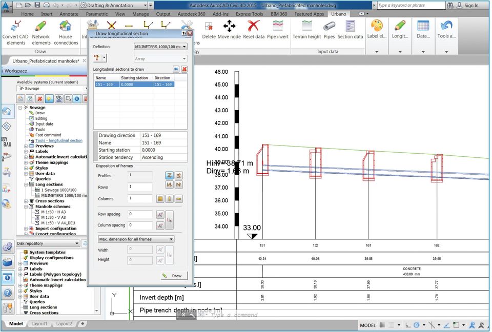
12 Urbano Canalis Sewage & stormwater design, calculation and analysis software Urbano Canalis will support your workflow from start to finish regardless of project type. You will benefit from the speed and accuracy of the dynamic design model while enjoying great design and drafting flexibility thanks to the configuration system. Data exchange with complementary software is built-in with more than a dozen supported file formats. To complete the offer, there is a full set of calculation and analysis tools at your disposal. Key functions Long section and Invert design Urbano Canalis includes a comprehensive set of tools and configurations adapted to the specific requirements of sewage and stormwater long sections design. Special tools follow each step of the design process including data selection, long section and invert editing, long section management and preparation for plotting. You can move, delete or copy long sections and you can exchange the currently used configuration with another one. The change of any feature like color, text alignment, size, line type, block type, data to display etc. can be stored in a new configuration. Invert editing is especially powerful. The program offers full interoperability of manual and automatic invert design tools. This brings unparalleled flexibility to pipe invert design. Manual editing is fully interactive enabling you to draw directly in the long section and preview the results of any editing operation before it is executed. You can use smart editing functions like insert a manhole directly in the long section, adjust the manhole drop or straighten the invert by line or by slope. The editing functions can be performed before or after the input of pipes and manholes. Automatic pipe invert editing is based on a set of criteria that will produce a best fit solution. The criteria include maximum and minimum depth and slope, the preference to use drop manholes, existing lateral inlets and previously drawn pipe inverts. All criteria are set in a single window which makes it simple to retain control. A solution based on the criteria will be calculated and applied to the selected long sections. And the best thing is all the settings can be stored in a configuration for additional use, editing and exchange with other team members. Prefabricated manholes Urbano includes the option to determine the exact prefabricated concrete elements that will be used in the building of a manhole. The included prefabricated elements catalog was created according to EN and DIN V standards and can be extended with user created elements. The composition of elements is based on pipe inverts and manhole depth with dynamic control and adjustment of total manhole height. Based on the composed manholes you can create element lists and reports. House connections House connections can be created with manual and automatic drafting tools or by a conversion of CAD elements like lines and polylines. Additional options include setting terrain heights and invert elevations, positioning labels and selecting pipe type and diameter. Catchment & influence areas Catchment areas for rain flow calculations are created from closed areas drawn with lines or polylines. This also applies to sub-areas with different runoff coefficients like roofs or driveways. Influence areas for sanitary and industrial flows are created similarly to catchment areas and based on specific inhabitant density. Flow & hydraulic calculation The flow calculation manager handles various national and international methods like calculating rain flow with IDF curves, waste flow from influence areas, additional rain and foreign water flows, transit flows and total flow. Calculation results are based on configurations allowing you to track all inputs and outputs. Hydraulic dimensioning is performed according to Darcy-Weisbach and Prandtl-Colebrook equations.

13 We use Urbano for more than a year for the purposes of design and calculation of sewage and water distribution networks as we can develop our projects with much less time than before. We are especially impressed with the ability to import our old network data to Urbano and edit them according to our needs. Andreas Höhenberger, HÖHENBERGER Engineering ZT GmbH, Oberwart, Austria

14 Urbano Hydra Water distribution design, calculation and analysis software Urbano Hydra will support your workflow from start to finish regardless of project type. You will benefit from the speed and accuracy of the dynamic design model while enjoying great design and drafting flexibility thanks to the configuration system. Data exchange with complementary software is built-in with more than a dozen supported file formats. To complete the offer, there is a full set of calculation and analysis tools at your disposal. Key functions Automatic pipe diameter optimization For water distribution networks, calculating and determining optimal pipe diameters is no straightforward task. Depending on network size and topology type, it can become increasingly complex and time consuming. The intricate dependencies of flow, velocity, pressure, flow direction and pipe diameter are especially demanding in loop network topologies. Urbano Hydra solves this problem for both branch and loop network topologies with the use of advanced hydraulic calculation methods. The automatic pipe diameter optimization procedure is based on a genetic algorithm that mimics the natural selection process to calculate an optimal solution. In this case, the algorithm tries to determine optimal pipe diameters based on a required flow velocity in the water distribution network. You set and control all input values, calculation settings and required results making the process simpler to understand and manage. The results can be further refined using post-processing and editing tools. Harnessing the power of the new automatic pipe diameter optimization calculation will significantly increase productivity and quality of the final design. Connection to EPANET and other hydraulic modeling software EPANET is the worldwide standard software for hydraulic calculations of water distribution networks and most hydraulic modeling software use the EPANET file format to exchange data. Urbano can be used to determine all pipe network information including water demands, pipes, valves, pumps, reservoirs etc. The prepared data can then be exported to any EPANET compatible software for hydraulic modeling. The modeling results can be imported to Urbano and become part of the project. Hydraulic calculation Urbano uses the EPANET engine for a snapshot hydraulic calculation. This action requires the same data input as if you were to export the data to EPANET. The snapshot calculation can be performed to get some basic understanding of the network in a short amount of time. Long section and invert design Urbano Hydra includes a comprehensive set of tools and configurations adapted to the specific requirements of long section design for water distribution networks. Special tools follow each step of the design process including data selection, long section and invert editing, long section management and preparation for plotting. You can move, delete or copy long sections and you can exchange the currently used configuration with another one. The change of any feature like color, text alignment, size, line type, block type, table data and more, can be stored in a new configuration. Invert editing is especially powerful offering full interoperability of manual and automatic invert design tools. You can take advantage of a new function that enables the automatic determination of pipe inverts with respect to reducing the number of needed air release and sludge release valves. This brings unparalleled flexibility to pipe invert design. Node assembly schema design You can create detailed node schematics based on network nodes and a catalog of assembly elements e.g. fittings and valves. You can create custom parametric elements or elements from AutoCAD blocks. A table with part name and quantity is generated automatically.

15 Using Hydra and Canalis we have fast and reliable results, the ability to view intersections of systems and hydraulic calculations of the network in minutes. We estimate the design efficiency with Hydra and Canalis to be about 10 km of network per day. Marius Andrei, S.C RAJA S.A., Constanța, Romania

16 Urbano Data Urbano Data enables you to create data import and export configurations to take advantage of a full BIM workflow. Key functions Data import and export Urbano solves the issues of reliable data exchange between different software systems with import and export configurations. You can create custom configurations for every project and data source. This also makes it easy to test the import or export procedure in case you are dealing with a complex data structure. The imported data of nodes and sections is used to draw a pipe network directly. You can then proceed with editing and analysis in the usual way. Import and export configurations can be stored, exchanged with the.dwg file or reused as a starting point for a new project solution. Supported data exchange formats include.shp (ESRI ArcGIS),.tab (MapInfo), Text files and OLE DB databases like Oracle, MS SQL, Access and PostgreSQL. Linking to external data sources If you want to use data from an external source but do not want to import the data and increase the file size, you can create a data link. This way the data is read directly from the external data source while the project size remains constant. Links are based on configurations and the supported data formats are the same as for the import/ export. Linking to external documents For such purposes, you can create a configuration that will link an external file e.g. picture or video, to a node or section.

17 Urbano Geo Terrain cross sections, multiple pipe trenches and surveying tools Key functions Cross sections You can create dynamic cross sections that include terrain features and all infrastructure networks. Cross sections are based on configurations and are automatically refreshed on any change in layout or long sections. You can create multiple terrain lines, hatch cut and fill surfaces and add custom object symbols. The calculation of surfaces and volumes is based on the specified terrain lines. Trench for multiple infrastructure networks A new tool enables the creation of complex trenches with multiple benching that can accommodate more than one infrastructure network e.g. water, storm, gas, electricity. You can create cross sections and excavation calculations based on the trench settings. Points and connections Points can be imported from various sources like.txt files and OLE DB databases. You can create additional points using polar or orthogonal measurements, interpolation, arc intersection or conversion from 3D points and linear objects. Connecting lines can be created in 2D or 3D, as lines or polylines, with different line types and styles. You can create long sections based on any connection line.

18 Urbano Polygon Urbano Polygon provides advanced creation, editing and analysis of parcel topologies. It includes an advanced analysis that determines the exact parcels of a pipe run. Key functions Polygon topology Polygon topology is a special type of data structure used for creating parcels or zones. You can create a polygon topology in an automated procedure by converting existing lines and polylines. The automated procedure will always create parcels that conform to the requirements. You can use post-processing cleanup and editing tools on all nonconforming lines and polylines. Additional information like parcel number, type and owner can be imported from a database or converted from AutoCAD texts. You can use standard Urbano tools to edit, label, search, query and analyze the parcels. Polygon/Pipe intersections This is a special analysis type that allows you to detect intersection points between pipe networks and parcels. The results of the intersection can be stored in custom data variables which can be added to long section configurations. This will, for instance, allow you to control the type of parcel a pipe run is going through. The Polygon/ Pipe connection is dynamic and any change in the pipe run or the parcel will be refreshed automatically in all data views. Analysis tools Urbano includes a number of specific parcel analysis tools. To improve project insight you can perform buffer, union, intersection and overlay analyses. You can create analysis reports using thematic maps and data tables.

19 Urbano Raster & Vector Urbano Raster&Vector provide productivity tools for working with large amounts of raster and vector maps. Key improvements over a traditional workflow include image grouping, smart display tools and layer filtering. Supported raster file types -.tfw,.jgw,.ecw and GeoTIFF Supported vector file types -.dwg,.dgn,.dwf and.pdf Key functions Grouping Images can be imported one by one, by reading a folder structure or from a database. Groups can be made according to any criteria e.g. image scale, content or location. Each group is named which makes it easy to select and display appropriate images. Smart display options By default, maps are displayed only with a polygon boundary and the image name. This enables the program to display thousands of image boundaries and still retain great performance. There are several methods for displaying the maps e.g. picking images from the drawing or the list, displaying all images crossed by a line or a polygon or displaying all images visible in the current view. Layer filtering for vector images While attaching files you can use content filtering e.g. you can filter attached files based on layer. This enables you to use general purpose maps with many infrastructure types and still keep full control over the level of detail that is displayed in the drawing.

20 Advantages of using Urbano with the Autodesk Infrastructure Design Suite Urbano pipe networks are based on standard AutoCAD elements: lines and blocks. Any additional data is stored directly in the.dwg file. The synergy of Urbano and Autodesk products creates clear-cut advantages: Autodesk product AutoCAD AutoCAD Map 3D Advantage with Urbano Conversion of Line, LW Polyline, 2D Polyline, 3D Polyline to Urbano sections. Conversion of Blocks to Urbano Nodes Conversion of Text and Block attributes to Urbano data like invert elevations, pipe diameters, channel names etc. Use of standard AutoCAD tools for additional annotations and plot preparation. Import/export of existing pipe networks from/to a database. Project amendment with digital terrain models or terrain heights, long sections, trenches, cross sections and more AutoCAD Civil 3D Direct use of AutoCAD Civil 3D s digital terrain model. Bidirectional data exchange for pipes and structures Autodesk Infraworks Autodesk Navisworks Export of Urbano networks to AutoCAD Civil 3D and Infraworks. Export of Urbano pipe networks as 3D solid objects for additional clash analysis

21 Urbano Hydra/Canalis is suitable for large infrastructure projects. The software is multifunctional and gives freedom to a designer to develop complex calculations and designs. Urbano Hydra/Canalis helped us to develop water supply and sewerage designs with a very short design time and with the best quality. Dr. Eng. Atanas Paskalev, Manager, Aquapartner LTD, Sofia, Bulgaria
22 With Urbano, we already designed more than 4000 km of sewage and water distribution networks. From our point of view, Urbano software is the complete solution. Andrei Bulumete, Chief Designer, Romair Consulting, Bucharest, Romania
23 Urbano is being developed for more than 20 years with a firm dedication to meeting customer needs. The program is accompanied by numerous learning resources, dedicated technical support teams and excellent customer care. With the support of our authorized resellers we currently deploy the program in more than 10 language versions to more than 20 countries worldwide. StudioARS was founded in 1990 in Croatia. Since the very beginning our goal has been the implementation of advanced CAD and engineering technologies. Our development is based on Autodesk technology and we develop modern, reliable and flexible solutions for everyday work. Urbano, Canalis, Hydra are registered trademarks of Studio ars d.o.o. in Croatia and/or other countries. All other brand names, product names, or trademarks belong to their respective holders. Studio ars reserves the right to change products and services availability, specifcations and/or pricing at any time without notice. Studio ars is not responsible for any errors that may appear in this document Studio ars d.o.o. All rights reserved.
24 StudioARS d.o.o. Cesta dalmatinskih brigada 24b Matulji, Croatia Tel Fax studioars@studioars.hr youtube.com/c/studioarscompany
Using Hydraflow Storm Sewers Extension with AutoCAD Civil 3D 2008: A Recommended Workflow
 AutoCAD Civil 3D 2008 Using Hydraflow Storm Sewers Extension with AutoCAD Civil 3D 2008: A Recommended Workflow The ability to perform storm water hydrology and hydraulic (H&H) tasks is crucial to civil
The Shorten AutoCAD the road solution for mechanical, electrical, to done. and plumbing engineering. AutoCAD AutoCAD.
 The Shorten AutoCAD the road solution for mechanical, electrical, to done. and plumbing engineering. AutoCAD AutoCAD Civil 3D MEP 2009 More Productivity, Same Skills Michigan-based Peter Basso Associates
Autodesk Civil 3D Styles: A Guide to the Fundamentals
 AUTODESK CIVIL 3D WHITE PAPER Autodesk Civil 3D Styles: A Guide to the Fundamentals About the Author: Mark Scacco, PE, is the founder and president of Engineered Efficiency, Inc., a technology consulting
Certified Instructors & Curriculum
 Our Promise. TPM is dedicated to provide the most extensive and high-quality training programs to help you maximize your investment. Although the investment in time and money may seem substantial, it will
Available in Base or Survey Standard or Survey Professional series with different modules add-ons to suit your technical requirement and budget.
 World First Leading the Surveying and Civil Engineering software application, civilcad 6 is the world first application of its kind to run in the Plug and Go concept. Delivered pre-installed on a customised
Using CAD Data in ArcGIS
 Esri International User Conference San Diego, California Technical Workshops July 27, 2012 Using CAD Data in ArcGIS Jeff Reinhart & Phil Sanchez Agenda Overview of ArcGIS CAD Support Using CAD Datasets
Road Rehabilitation and Reconstruction Using AutoCAD Civil 3D
 Road Rehabilitation and Reconstruction Using AutoCAD Civil 3D Contents Introduction... 3 Introduction to Corridor Targets... 3 Surface Targets... 4 Width and Offset Targets... 5 Elevation or Slope Targets...
Questions and Answers for Citrix Ready Software
 AutoCAD Map 3D 2009 Questions and Answers for Citrix Ready Software AutoCAD Map 3D software is one of the leading engineering platforms for creating and managing spatial data. Bridging the gap between
Autodesk Solutions for Environmental Engineering. Engineering a better environment
 Autodesk Solutions for Environmental Engineering Engineering a better environment Better Engineering, Faster Design and deliver environmental engineering projects better, faster, and more economically.
Effective Collaboration using Revit Structure and AutoCAD MEP
 REVIT STRUCTURE Effective Collaboration using Revit Structure and AutoCAD MEP This white paper explains how structural engineers using Revit Structure software and mechanical/electrical/plumbing (MEP)
Setting a New Standard for 2D Design
 Setting a New Standard for 2D Design Plant Design Software Suite VERSION 2008 Raising the Bar on Piping Design By combining proven technologies with AutoCAD s advanced graphics engine, PROCAD has created
TABLE OF CONTENTS. INTRODUCTION... 5 Advance Concrete... 5 Where to find information?... 6 INSTALLATION... 7 STARTING ADVANCE CONCRETE...
 Starting Guide TABLE OF CONTENTS INTRODUCTION... 5 Advance Concrete... 5 Where to find information?... 6 INSTALLATION... 7 STARTING ADVANCE CONCRETE... 7 ADVANCE CONCRETE USER INTERFACE... 7 Other important
64 Bits of MapInfo Pro!!! and the next BIG thing. March 2015
 64 Bits of MapInfo Pro!!! and the next BIG thing March 2015 MapInfo Professional v12.5 Themes Cartographic output Performance improvements Ability to work directly with a map in a layout. An all new Layout
This high level land planning and design system will replace the land
 Performance Planning System () The following is a v1.3 feature analysis, which clarifies differences, between and American Planning Association (APA) Land Based Classification Standards (LBCS) for color
MultiREBAR CAD. www.multirebarcad.com
 MultiREBAR CAD Rebar Detailing Made Easy www.multirebarcad.com Who Uses MultiREBAR CAD? MultiREBAR is the complete concrete bar detailing solution and can be used by both detailers and Rebar fabricators.
How To Draw In Autocad
 DXF Import and Export for EASE 4.0 Page 1 of 9 DXF Import and Export for EASE 4.0 Bruce C. Olson, Dr. Waldemar Richert ADA Copyright 2002 Acoustic Design Ahnert EASE 4.0 allows both the import and export
Building Information Modeling for MEP Engineering. Revit MEP 2008
 Building Information Modeling for MEP Engineering Revit MEP 2008 Design Intuitively with Tools That Work the Way Engineers Think Revit MEP software is an intuitive design tool that works the way engineers
Ten Easy Steps to Intersections in AutoCAD Civil 3D
 in AutoCAD Civil 3D Robert Gadbaw Team Blue22 Ltd. CV110-2L This class takes students step by step through creating an intersection using Civil 3D 2009. Students will learn about alignments, profiles,
Questions and Answers
 Autodesk Factory Design Suite 2013 Questions and Answers Autodesk Factory Design Suite enhances the power of AutoCAD with the benefits of Digital Prototyping, so you spend less time drafting and more time
Working with Data from External Sources
 Working with Data from External Sources Bentley WaterCAD V8i supports several methods of exchanging data with external applications, preventing duplication of effort and allowing you to save time by reusing
Design without compromise. Autodesk Revit. Architecture
 Design without compromise. Autodesk Revit Architecture Definitive Design From conception to construction documentation, design projects within an intuitive environment. Building information modeling and
Autodesk Revit Architecture. Design without compromise.
 Autodesk Revit Architecture Design without compromise. Definitive Design From conception to construction documentation, design projects within an intuitive environment. Building information modeling and
Autodesk Robot Structural Analysis Professional 2010. Break it down before you build it up.
 Autodesk Robot Structural Analysis Professional 2010 Break it down before you build it up. Building Information Modeling for Structural Engineering Integrated tools for modeling, coordination, analysis,
Setting a New Standard for 2D Design
 Setting a New Standard for 2D Design Plant Design Software Suite VERSION 2008 Raising the Bar on Piping Design By combining proven technologies with AutoCAD s advanced graphics engine, PROCAD has created
Autodesk Vault Family of Products. Manage your entire design.
 Autodesk Vault Family of Products Manage your entire design. Stay In Control Imagine finding design data in seconds. Sharing digital prototyping information securely with team members across the world.
AHUDesigner. The Air Handling Units selection software. Product description
 AHUDesigner The Air Handling Units selection software Product description Table of contents INTRODUCTION... 4 AHU SELECTION SOFTWARE FUNCTIONAL SPECIFICATIONS... 5 Definition of unit configuration... 5
MrSID Plug-in for 3D Analyst
 LizardTech MrSID Plug-in for 3D Analyst User Manual Copyrights Copyright 2009 2010 LizardTech. All rights reserved. Information in this document is subject to change without notice. The software described
 Development tools to create Web-GIS applications DbMAP ASJ the best solution to easily publish GIS data from existing spatial databases and distributed GIS data sources Easily designs, produces, and publishes
Use this translator to save ArchiCAD layouts/views in DXF/DWG format if you plan to continue
 Tip Sheet ArchiCAD 11 Mark Horrocks Graphisoft New Zealand May 2007 DWG Translator In Architectural practice you often send and receive content from co-working Structural, Mechanical or Electrical Engineers.
Questions and Answers
 AutoCAD Raster Design 2012 Questions and Answers Make the most of rasterized scanned drawings, maps, aerial photos, satellite imagery, and digital elevation models. Get more out of your raster data and
TechnicalNotes. Terramodel Software for Construction
 TechnicalNotes Terramodel Software for Construction INTEGRATED SOFTWARE FOR IMPROVED CONSTRUCTION PROCESSES Today s construction industry demands high accuracy and maximum efficiency throughout the construction
Solid Edge Diagramming
 Solid Edge Diagramming White Paper Integrated, process-specific diagramming for P&ID, electrical and hydraulic diagrams White Paper Solid Edge Diagramming 2 Contents Integrated diagramming... 3 Industry-standard
A Web services solution for Work Management Operations. Venu Kanaparthy Dr. Charles O Hara, Ph. D. Abstract
 A Web services solution for Work Management Operations Venu Kanaparthy Dr. Charles O Hara, Ph. D Abstract The GeoResources Institute at Mississippi State University is leveraging Spatial Technologies and
com www. IRRIEXPRESS IRRIGATION DESIGN SOFTWARE
 Established 1963 IRRIEXPRESS IRRIGATION DESIGN SOFTWARE Create And Validate Irrigation Designs In Minutes. Design comprehensive irrigation projects with pivots, sprinklers and drip using a simple, intuitive
Autodesk Revit LEARNING PATH BUILDING DESIGN SUITE
 Autodesk Revit LEARNING PATH FUNDAMENTALS Duration: 3 days Cost: R5 500 (excl VAT) Revit MEP Duration: 3 days Cost: R5 500 (excl VAT) Revit Structure Duration: 3 days Cost: R5 500 (excl VAT) REVIT ADVANCED
JumpStart Guide. Trimble QuickPen PipeDesigner 3D Software
 L JumpStart Guide Trimble QuickPen PipeDesigner 3D Software Revision A February 2013 F Englewood Office Trimble Navigation Limited 384 Inverness Parkway, Suite 200 Englewood, Colorado 80112 (800) 234-3758
How To Use Gss Software In Trimble Business Center
 Trimble Business Center software technical notes Trimble Business Center Software Makes Processing GNSS Survey Data Effortless Trimble Business Center is powerful surveying office software designed to
Get to know your Autodesk Design and Creation Suites 2014
 Get to know your Design and Creation Suites 2014 Design and Creation Suites 2014 offer more tools and cloud services so you can take advantage of smoother workflows, better access to project information,
Design without compromise. Autodesk Revit. Architecture 2010
 Design without compromise. Autodesk Revit Architecture 2010 BIM Simply a Better Way of Working Deliver projects faster, more economically, and with enhanced potential for reduced environmental impact.
CXQuotes Doors and Windows Quotation software. Cogitrix
 CXQuotes Doors and Windows Quotation software Cogitrix Table of content TABLE OF CONTENT... 2 TABLES OF PICTURES... 6 SOFTWARE FEATURES... 7 QUICK...7 REDUCING ERRORS...7 PRINT QUALITY...7 PRICES COMPARISON...7
Questions and Answers
 AutoCAD Architecture 2010 Questions and Answers AutoCAD Architecture 2010 software the version of AutoCAD software for architects. Creating designs and documentation is much more efficient using the software
Explore. Analyze. Optimize. AutoCAD. Civil 3d
 Explore. Analyze. Optimize. AutoCAD Civil 3d A Powerful Building Information Modeling Solution for Civil Engineering Use an integrated process built on a coordinated, consistent, digital model for design,
SMARTEAM - Editor Administrator Guide
 SMARTEAM - Editor Administrator Guide SmarTeam Corporation Ltd. Web: www.smarteam.com Tel: +972-9-7644000 5 Hagavish St., P.O.B 7020 Email: info@smarteam.com Fax: +972-9-7644001 Kfar Saba, Israel 44641
Test Data Management Concepts
 Test Data Management Concepts BIZDATAX IS AN EKOBIT BRAND Executive Summary Test Data Management (TDM), as a part of the quality assurance (QA) process is more than ever in the focus among IT organizations
AutoCAD Architecture 2012 UK Content Tools
 AutoCAD Architecture 2012 UK Content Tools Contents Contents... 1 Installation... 2 Loading the utilities... 2 Utilities Overview... 3 Menu and Toolbar... 3 Content Generation... 3 Content Publishing...
{ { { Meeting Date 08/03/10. City of Largo Agenda Item 24. Leland Dicus, P.E., City Engineer
 City of Largo Agenda Item 24 Form Revision Date: 10/19/09: Meeting Date 08/03/10 Presenter: Leland Dicus, P.E., City Engineer Department: CD Community Development TITLE: GIS PROGRAM UPDATE The implementation
Digital Prototyping: Questions and Answers
 Autodesk Manufacturing Digital Prototyping: Questions and Answers 1. What is a digital prototype? A digital prototype is created with Autodesk Inventor software and is a digital simulation of a product
Strategies to Speed Collaboration and Data Management Using Autodesk Vault and Riverbed WAN Optimization Technology
 Autodesk Vault Professional Manufacturing Industry Marketing 2011 Strategies to Speed Collaboration and Data Management Using Autodesk Vault and Riverbed WAN Optimization Technology Geographically dispersed
imc FAMOS 6.3 visualization signal analysis data processing test reporting Comprehensive data analysis and documentation imc productive testing
 imc FAMOS 6.3 visualization signal analysis data processing test reporting Comprehensive data analysis and documentation imc productive testing imc FAMOS ensures fast results Comprehensive data processing
What's New in Heavy Civil Construction Software. Chris Richardson HCC-6898
 What's New in Heavy Civil Construction Software Chris Richardson HCC-6898 Segment Initiatives Make it simple Easy to use Integrated with the Heavy Civil Construction portfolio Workflow improvements Provide
Layout Tutorial. Getting Started
 Getting Started Layout Tutorial This tutorial will explain how create a layout template, send views to a layout page, then save the document in PDF format. In this tutorial you will learn about: Creating
What s New in Autodesk Revit 2014
 Building Design Suite 2014 What s New in Revit 2014 * Revit 2014 software is only available as part of the Building Design Suite 2014 Premium and Ultimate Editions. New & Enhanced Features Platform & For
Performance by design. Autodesk Revit MEP
 Performance by design. Autodesk Revit MEP Step up to the challenge. Autodesk Revit MEP software helps mechanical, electrical, and plumbing engineering firms meet the heightened demands of today s global
Data Integration for ArcGIS Users Data Interoperability. Charmel Menzel, ESRI Don Murray, Safe Software
 Data Integration for ArcGIS Users Data Interoperability Charmel Menzel, ESRI Don Murray, Safe Software Product overview Extension to ArcGIS (optional) Jointly developed with Safe Software Based on Feature
Business Insight Report Authoring Getting Started Guide
 Business Insight Report Authoring Getting Started Guide Version: 6.6 Written by: Product Documentation, R&D Date: February 2011 ImageNow and CaptureNow are registered trademarks of Perceptive Software,
Creating 2D Drawings from 3D AutoCAD Models
 Creating 2D Drawings from 3D AutoCAD Models David Piggott CrWare, LP GD205-2P This class explores the various techniques in creating 2D part and assembly drawings from 3D AutoCAD models. As part of the
MatchPoint Technical Features Tutorial 21.11.2013 Colygon AG Version 1.0
 MatchPoint Technical Features Tutorial 21.11.2013 Colygon AG Version 1.0 Disclaimer The complete content of this document is subject to the general terms and conditions of Colygon as of April 2011. The
Pageflex Persona Cross Media Suite
 Pageflex Persona Cross Media Suite Pageflex Persona Cross Media Suite gives you the power to create personalized cross media campaigns using the award-winning variable data capability of Pageflex on your
keytech keytech 13 FP 2 - What's New
 keytech keytech 13 FP 2 - What's New keytech 13 - What's New Table of Contents 1. 1.1 1.2 1.3 1.3.1 1.3.1.1 1.3.1.2 1.3.2 1.3.2.1 1.3.2.2 1.3.2.3 1.3.2.4 1.3.3 1.3.4 1.4 1.4.1 1.4.2 1.5 1.6 Structured
Civil 3D 2009 New Features
 Civil 3D 2009 New Features User Interface Workspaces and menus Menu Browser Using the large icon in the upper left corner of your screen, you can access all menus and also search for any command, recent
W13. Storm Drainage Layout with InRoads Storm & Sanitary. XM Edition TRN010130-1/0001
 W13 Storm Drainage Layout with InRoads Storm & Sanitary XM Edition TRN010130-1/0001 Copyright Information Trademarks AccuDraw, Bentley, the B Bentley logo, MDL, MicroStation and SmartLine are registered
Explore. Analyze. Optimize. AutoCAD. Civil 3d
 Explore. Analyze. Optimize. AutoCAD Civil 3d A Powerful Building Information Modeling Solution for Civil Engineering Use an integrated process built on a coordinated, consistent, digital model for design,
Steel construction. Miscellaneous steel. Industrial structures. www.graitec.com
 Steel construction Miscellaneous steel BIM SOFTWARE FOR STRUCTURAL STEEL ENGINEERING, DETAILING AND FABRICATION www.graitec.com Industrial structures Advance Steel is specifically designed for structural
Suggested Application Options Settings for Autodesk Inventor
 Suggested Application Options Settings for Autodesk Inventor TEL: 0165 666 24 14 support@envisageuk.com PLEASE NOTE, THIS IS ONLY A GUIDE ANY QUESTIONS AT ALL PLEASE RING The following are suggested application
EZManage SQL Pro. Quick guide for installation and implementation
 EZManage SQL Pro Quick guide for installation and implementation The purpose of this document is to guide you through the process of implementing EZManage SQL using SQL Server Databases. EZManage SQL is
TOPOGRAPHICAL SURVEY REPORT - PART OF L.R No. 7413/11 Done on February 2015 at International Union for Conservation of Nature (IUCN) Eastern African
 Eastern African") TOPOGRAPHICAL SURVEY REPORT - PART OF L.R No. 7413/11 Done on February 2015 at International Union for Conservation of Nature (IUCN) Eastern African Regional Office 01 CHAPTER ONE Checklist Page 2 of 8
TOPOGRAPHICAL SURVEY REPORT - PART OF L.R No. 7413/11 Done on February 2015 at International Union for Conservation of Nature (IUCN) Eastern African Regional Office 01 CHAPTER ONE Checklist Page 2 of 8
Online Packaging Management Solution
 Online Packaging Management Solution WebCenter WebCenter is a powerful web-based Packaging Management platform to manage your business process, approval cycles and digital packaging assets. Specification
Pro/ENGINEER Wildfire 4.0 Basic Design
 Introduction Datum features are non-solid features used during the construction of other features. The most common datum features include planes, axes, coordinate systems, and curves. Datum features do
powered by Leica RedLine Tailor-made Site Solutions
 powered by Leica RedLine Tailor-made Site Solutions Redline Your Efficiency Position yourself for success with Leica RedLine Earth s most impressive landscapes were developed over millions of years, but
Microsoft Office System Tip Sheet
 The 2007 Microsoft Office System The 2007 Microsoft Office system is a complete set of desktop and server software that can help streamline the way you and your people do business. This latest release
UL Engineering Services & Software Private Limited. Engineering Base Software
 UL Engineering Services & Software Private Limited Engineering Base Software The Engineering software Ebase which can be used for various Documentation, Drawings, Datasheets, BOM, Tag list, Cable schedule,
UNIVERSITY OF WASHINGTON Facilities Services Design Guide. Civil. Topographical Survey. Design Evaluation. Construction Submittals
 This section applies to design standards and procedures involved in the field location and plotting of all natural objects and surface improvements. This section also includes the requirements for submittal
How To Improve Gis Data Quality
 An Esri White Paper July 2011 GIS Data Quality Best Practices for Water, Wastewater, and Stormwater Utilities Esri, 380 New York St., Redlands, CA 92373-8100 USA TEL 909-793-2853 FAX 909-793-5953 E-MAIL
AutoCAD Structural Detailing 2011. Getting Started with AutoCAD Structural Detailing, Reinforcement module
 AutoCAD Structural Detailing 2011 Getting Started with AutoCAD Structural Detailing, Reinforcement module 2010 Autodesk, Inc. All Rights Reserved. Except as otherwise permitted by Autodesk, Inc., this
Vico Office R3.0 Help
 1 Vico Office R3.0 Help User guide 2 Contents 3 Vico Office R3.0 Help Revision 1 4 Vico Office Introduction Welcome to Vico Office, Vico's integrated Virtual Construction environment. The Vico Office Suite
AutoCAD Civil 3D 2008
 AutoCAD Civil 3D 2008 Pump It Up All the Way to the Last Sheet! Dave Young S4-2 Course Summary: Pressure pipes such as water and force mains are simple to design. But when it comes to putting them on paper,
Getting Started With LP360
 Getting Started With LP360 10/30/2014 1 Contents What is LP360?... 3 System Requirements... 3 Installing LP360... 4 How to Enable the LP360 Extension... 4 How to Display the LP360 Toolbar... 4 How to Import
ArcGIS. Server. A Complete and Integrated Server GIS
 ArcGIS Server A Complete and Integrated Server GIS ArcGIS Server A Complete and Integrated Server GIS ArcGIS Server enables you to distribute maps, models, and tools to others within your organization
Certified Translation from German
 Certified Translation from German Annexes to the Agreements Table of contents Annex 1 Scope of the licence Annex 2 System Requirements Annex 3 Modules Annex 4 Hotline hours Annex 5 Trainings Annex 6 Price
imc FAMOS 6.3 visualization signal analysis data processing test reporting Comprehensive data analysis and documentation imc productive testing
 imc FAMOS 6.3 visualization signal analysis data processing test reporting Comprehensive data analysis and documentation imc productive testing www.imcfamos.com imc FAMOS at a glance Four editions to Optimize
How To Create A View Frame In 3D
 12/4/2008-10:00 am - 11:30 am Room:Palazzo O-P (5th) The Secrets of Cutting Plan and Profile Sheets in AutoCAD Civil 3D Michelle Rasmussen - Application Engineer, IMAGINiT Technologies CV304-1P In this
SIMATIC. WinCC V7.0. Getting started. Getting started. Welcome 2. Icons 3. Creating a project 4. Configure communication 5
 SIMATIC WinCC V7.0 SIMATIC WinCC V7.0 Printout of the Online Help 1 Welcome 2 Icons 3 Creating a project 4 Configure communication 5 Configuring the Process Screens 6 Archiving and displaying values 7
Effective Collaboration
 AUTODESK BUILDING SOLUTIONS Effective Collaboration Exporting Revit Architecture Models as ACIS Solids for Use in AutoCAD MEP The intent of this paper is to explain a process by which architects using
INNOVATOR. The integrated tool suite for business process and software engineering
 The integrated tool suite for business process and software engineering Use the synergy: The integrated tool suite for business process and software engineering is the only integrated tool suite for business
Release 2.1 of SAS Add-In for Microsoft Office Bringing Microsoft PowerPoint into the Mix ABSTRACT INTRODUCTION Data Access
 Release 2.1 of SAS Add-In for Microsoft Office Bringing Microsoft PowerPoint into the Mix Jennifer Clegg, SAS Institute Inc., Cary, NC Eric Hill, SAS Institute Inc., Cary, NC ABSTRACT Release 2.1 of SAS
SECTION 5 DRAFTING STANDARDS
 SECTION 5 DRAFTING STANDARDS 1 SECTION FIVE TABLE OF CONTENTS Description Page TABLE OF CONTENTS... 5-2 GENERAL... 5-3 DRAFTING STANDARDS... 5-5 DRAFTING MINIMUM REQUIREMENTS HANDOUT... 5-8 2 GENERAL 1.
We Answer All Your Localization Needs!
 partner We Answer All Your Localization Needs! Version: 2.0 23.05.2014 California, U.S.A Bucharest, Romania (US) +1.714.408.8094 (RO) +40.740.182.777 www.i-t-local.com info@i-t-local.com 1 of 13 Our Company
Chapter 23: Drafting in Worksheet View
 Chapter 23: Drafting in Worksheet View Worksheet View is a powerful, 2D production drafting module. Here you can find all of the drawing and editing tools needed to create fast, accurate, detailed working
How To Set Up Safetica Insight 9 (Safetica) For A Safetrica Management Service (Sms) For An Ipad Or Ipad (Smb) (Sbc) (For A Safetaica) (
 For A Safetrica Management Service (Sms) For An Ipad Or Ipad (Smb) (Sbc) (For A Safetaica) (") SAFETICA INSIGHT INSTALLATION MANUAL SAFETICA INSIGHT INSTALLATION MANUAL for Safetica Insight version 6.1.2 Author: Safetica Technologies s.r.o. Safetica Insight was developed by Safetica Technologies
SAFETICA INSIGHT INSTALLATION MANUAL SAFETICA INSIGHT INSTALLATION MANUAL for Safetica Insight version 6.1.2 Author: Safetica Technologies s.r.o. Safetica Insight was developed by Safetica Technologies
Data Interoperability Extension Tutorial
 Data Interoperability Extension Tutorial Copyright 1995-2010 Esri All rights reserved. Table of Contents About the Data Interoperability extension tutorial...................... 3 Exercise 1: Using direct-read
The user forum is an excellent community in which to bounce questions off other professional users, like you.
 INTRODUCTION Thank you for your interest in MicroSurvey Point Prep Point Prep is a simple to use desktop based product designed specifically for the construction layout professional. Point Prep is used
Visio 2010 Tips and Techniques
 Visio 2010 Tips and Techniques Advanced Concepts and Solutions Mr. David A. Edson, M.Arch., MCP, MVP Visibility.biz CTE / Director of Consulting Services david@visibility.biz Wendy McGill Visio Solution
The GeoMedia Architecture Advantage. White Paper. April 2002. The GeoMedia Architecture Advantage Page 1
 The GeoMedia Architecture Advantage White Paper April 2002 The GeoMedia Architecture Advantage Page 1 Introduction What is wrong with GIS? GIS is primarily about data not software. Data should be independent
Type of Sewer Systems. Solomon Seyoum
 Type of Sewer Systems Solomon Seyoum 0 Learning objectives Upon completion of this lecture, the participants will be able to differentiate between types of sewer systems and discuss different aspects of
imaginit.com/autodeskcfd Scalable, robust fluid flow and thermal simulation solution
 Scalable, robust fluid flow and thermal simulation solution Fast, accurate, and flexible solution to test the fluid flow and thermal performance of your design Accurately predict behavior, optimize designs,
Technical Data Sheet: imc SEARCH 3.1. Topology
 : imc SEARCH 3.1 Database application for structured storage and administration of measurement data: Measurement data (measurement values, measurement series, combined data from multiple measurement channels)
FDOT Plans Production Tools
 FDOT State Kit for AutoCAD Civil 3D Mike Racca CADD APPLICATIONS SUPPORT Florida Department of Transportation (ECSO) Email: Mike.Racca@dot.state.fl.us Phone: 850-245-1631 GENERAL Civil 3D Plan Production
Sage MAS 90 and 200 ERP
 Sage MAS 90 and 200 ERP What s New in Sage MAS 90 and 200 4.4? Something for Everyone in 4.4 Based on the solid foundation that Sage MAS 90 and Sage MAS 200 ERP solutions have continued to build on for
3D Model of the City Using LiDAR and Visualization of Flood in Three-Dimension
 3D Model of the City Using LiDAR and Visualization of Flood in Three-Dimension R.Queen Suraajini, Department of Civil Engineering, College of Engineering Guindy, Anna University, India, suraa12@gmail.com
AutoCAD Civil 3D 2010 ESSENTIALS
 AutoCAD Civil 3D 2010 ESSENTIALS SDC PUBLICATIONS Schroff Development Corporation www.schroff.com Better Textbooks. Lower Prices. Visit our website to learn more about this and other books: AutoCAD Civil