Bentley Systems 3D Urban Modeling
|
|
|
- Tiffany Shields
- 7 years ago
- Views:
Transcription


1 Bentley Systems 3D Urban Modeling Peter Byrn, Chartered Surveyor Transport and Local Infrastructure
2 Agenda Hot News 3D City & Urban Modeling in MicroStation environment Bentleys approach 2
3 Hot news Bentley Incorporates Point Clouds as an Integrated Data Type Bentley have announced a partnership with Pointools to include their Vortex Engine API into the Bentley platform. This integration will allow users to reference and manage point cloud data within MicroStation for better project management 3

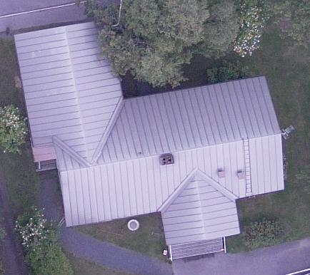
4 Ex.1 Danish Rail points 4

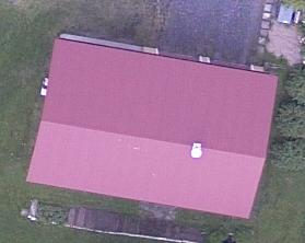
5 Ex.2 Odense City area points 5
6 3D City & Urban Modeling Bentleys approach 6


7 The 2D and 3D world 3D CAD/BIM File based; engineering projects High level of object details; e.g. buildings, bridges, roads Minor geographic area 2D and 2½D GIS Databases; high level of semantic information due to DB register connections Lower level of object details Large geographic area; covering a metropolis, region, nation 7
8 The best from both worlds - 3D City/Urban GIS A collection of functionality and information that allows the management of a city s infrastructure GIS/CAD/BIM integration From the overview of the 3D urban assets to detailed infrastructure from campus to large metropolis Intelligent objects from overview urban city objects to detailed engineering For seamless modeling, analysis, visualization and distribution to all stakeholders Bentleys approach is 3D City & Urban GIS 8


9 The 3D City GIS components 3D Modeling and Quality Control Aerial Survey Terrestrial Survey Extract, Transform & Load Persist, Manage and Share Explore, Analyze and Design in 3D 9

 Auto (discriminate vegetation) Import (Std format)")
 2-Textures, roof Manual")
 Manual (Large scale DTM, façade)")
 Auto (Façade) Manual (Façade, city")
 Manual (Inner structures)")
10 Traditional 3D modeling techniques Aerial Terrestrial ETL Photogrammetry LiDAR Mobile LiDAR & Photogrammetry Static LiDAR & Photogrammetry Land Surveying 0-DTM Manual or Auto (breaklines) Auto (discriminate vegetation) Import (Std format) 1- Blocks Manual or Auto (Footprint + height) Auto + Manual for complex cases Auto (Footprint + height) 2-Textures, roof Manual and some Auto (roof lines, textures/oblique) Auto but more manual edition Auto (Textures) Manual (Large scale DTM, façade) Auto (Import CAD/BIM) 3- Detailed Manual (Chimneys, dormers) Auto (Large scale DSM) Auto (Façade) Manual (Façade, city furniture) Manual (façade, city furniture) Auto (Import CAD/BIM) 4-Interior Manual (Inner structures) Manual (Inner structures) Auto (Import CAD/BIM) 10
11 What types of features are of special interest for a 3D Urban Map: Digital Terrain Model (DTM) Building objects Vegetation City and Urban furniture's Signs, lamp posts, fences etc. Infrastructure objects Bridges, tunnels, roads and related assets etc. 11


12 3D (building) modeling several methods Photogrammetry Aerial LiDAR Terrestrial LiDAR Conceptual Parametric rule based 12
13 Parametric 3D Urban Map modeling What is that? Modeling of 3D objects by use of 2/2½D Base Map and related attributes; geometry and metadata Definition of the rule sets decide the modeling process, variety, complexity and design of the city map What do you gain: A simplified 3D City/Urban model What Bentley technology are used? MicroStation V8i Generative Components V8i What data are needed? Building footprint Data model, geo-coded metadata 14


14 CAD & GIS Data Building metadata Building footprint Data sources: TAB, Shape, DXF, DWG, DGN, WFS, DB 15


")
")

15 Parametric rule set definition Object relations based on 1) generic rule sets, 2) the FOT data model and 3) public registers, e.g. BBR 16
16 FOT data model what is that? To promote continuity between the geographic databases throughout Denmark, an initiative to standardise geodata across the country has been launched. Will improve the efficiency of geodata sharing and public administration in general FOT Fælles Objekt Typer Common Object Types 17

17 Parametric 3D City Map modeling Pilot project This is the first prototype result Data City of Odense Live example 18
18 Derived products 3D City Maps many variations, since it depends on the pre-defined rule sets and the semantic level of detail. Overlay Maps, actuality and quality control Cluster Maps as input to 3. party solution, e.g. Telecom Radio & mobile unit signal propagation maps (as input to 3. party, Telecom, Railway service operators etc.) Noise propagation maps (as input to 3. party, e.g. SoundPLAN) 19
19 The SWOT analyse Strengths Easy to perform the modeling task one bottom click No specialized skills needed for the end-user A semantic very rich model inherit semantic data from original GIS Systems, DB s Not only building objects all FOT features can be generated and visualized Dynamic model can be updated on-the-fly from the 2D Base Map, attribute schemas Very fast processing few minutes Weaknesses A very new concept Will not represent the reality 100% - based on assumptions The data quality will have a direct impact of the modeling result 20


20 Object refinement Level of detail 21

21 Object refinement Which technologies are available? Predefined templates in GC for further enhancements MicroStation conceptual 3D modeling tools Photogrammetric workstations Classified and filtered LiDAR data Data Warehouses, e.g. 3D Google Warehouse Materials Textures Geodata BlomInfo 22


22 Building Information Model (BIM) integration Electrical HVAC Structural Piping INTERGRATED COORDINATED BIM Architectural Civil 23
23 3D Modeling with Bentley Sum-up Based on the same platform -> MicroStation Bentley users can go : From Images to 3D Objects From Point Cloud to 3D Objects From Data Models to 3D Objects From Land Surveying Measurement to 3D Objects From disparate available data to 3D Objects -> Seamless workflow -> Quality Control 24


24 Thank you 25
Welcome to Bentleyuser.dk Annual Meeting & Nordic Civil User Conference
 Welcome to Bentleyuser.dk Annual Meeting & Nordic Civil User Conference Iben Rue COWI Civil SIG Chairman ibru@cowi.dk Hotel Munkebjerg, Vejle, Denmark, 10. - 12. November 2014 Nordic Civil User Conference
3D Building Roof Extraction From LiDAR Data
 3D Building Roof Extraction From LiDAR Data Amit A. Kokje Susan Jones NSG- NZ Outline LiDAR: Basics LiDAR Feature Extraction (Features and Limitations) LiDAR Roof extraction (Workflow, parameters, results)
Geospatially Enabling the World: The Convergence of Geospatial and Architectural and Engineering Design
 Geospatially Enabling the World: The Convergence of Geospatial and Architectural and Engineering Design Geoff Zeiss Director of Technology Autodesk Map Middle East Dubai 2007 1 Overview Geospatial inflection
<Insert Picture Here> Data Management Innovations for Massive Point Cloud, DEM, and 3D Vector Databases
 Data Management Innovations for Massive Point Cloud, DEM, and 3D Vector Databases Xavier Lopez, Director, Product Management 3D Data Management Technology Drivers: Challenges & Benefits
3D Model of the City Using LiDAR and Visualization of Flood in Three-Dimension
 3D Model of the City Using LiDAR and Visualization of Flood in Three-Dimension R.Queen Suraajini, Department of Civil Engineering, College of Engineering Guindy, Anna University, India, suraa12@gmail.com
3D Point Cloud Analytics for Updating 3D City Models
 3D Point Cloud Analytics for Updating 3D City Models Rico Richter 25 th May 2015 INSPIRE - Geospatial World Forum 2015 Background Hasso Plattner Institute (HPI): Computer Graphics Systems group of Prof.
ERDAS PRO600. A state-of-the-art package for 3D feature collection and editing
 ERDAS PRO600 A state-of-the-art package for 3D feature collection and editing MicroStation design file graphics are displayed by PRO600 in full 3D stereo. PRO600 PRO600 is a highly sophisticated, function-rich
LASER SCANNER APPLICATION ON COMPLEX SHAPES OF ARCHITECTURE. PROFILES EXTRACTION PROCESSING AND 3D MODELLING.
 LASER SCANNER APPLICATION ON COMPLEX SHAPES OF ARCHITECTURE. PROFILES EXTRACTION PROCESSING AND 3D MODELLING. Carlo MONTI Full Professor E-mail: carlo.monti@polimi.it Luigi FREGONESE Research Assegnist
Managing Lidar (and other point cloud) Data. Lindsay Weitz Cody Benkelman
 Data. Lindsay Weitz Cody Benkelman") (and other point cloud) Data Lindsay Weitz Cody Benkelman Presentation Context What is lidar, and how does it work? Not this presentation! What can you do with lidar in ArcGIS? What does Esri recommend
(and other point cloud) Data Lindsay Weitz Cody Benkelman Presentation Context What is lidar, and how does it work? Not this presentation! What can you do with lidar in ArcGIS? What does Esri recommend
Teaching and Learning Strategies for 3D Urban and Landscape Modelling
 Teaching and Learning Strategies for 3D Urban and Landscape Modelling Martin SMITH, Andrew BURTON, and Nikolaos KOKKAS, United Kingdom Key words: 3D modelling, visualization, teaching, learning SUMMARY
High Resolution RF Analysis: The Benefits of Lidar Terrain & Clutter Datasets
 0 High Resolution RF Analysis: The Benefits of Lidar Terrain & Clutter Datasets January 15, 2014 Martin Rais 1 High Resolution Terrain & Clutter Datasets: Why Lidar? There are myriad methods, techniques
3D City Models for Simulation & Training Requirements on Next Generation 3D City Models
 3D City Models for Simulation & Training Requirements on Next Generation 3D City Models Frank Bildstein Rheinmetall Defence Electronics Rheinmetall Defence Electronics GmbH, Bremen, 07/2005 Contents Applications
FDOTSS3/SS4 DESIGN SURVEY WORKFLOW Part 2 of 3
 FDOTSS3/SS4 DESIGN SURVEY WORKFLOW Part 2 of 3 FOR BENTLEY OPEN ROADS TECHNOLOGY Introduction to Open Roads Importing Data into Bentley Survey (formally known as Data Acquisition) Visualization of the
Databases for 3D Data Management: From Point Cloud to City Model
 Databases for 3D Data Management: From Point Cloud to City Model Xavier Lopez, Ph.D. Senior Director, Spatial and Graph Technologies Oracle Program Agenda Approach: Spatially-enable the Enterprise Oracle
USING MOBILE LIDAR TO SURVEY A RAILWAY LINE FOR ASSET INVENTORY INTRODUCTION
 USING MOBILE LIDAR TO SURVEY A RAILWAY LINE FOR ASSET INVENTORY a Michael Leslar, Sales and Marketing Support Engineer b Gordon Perry, Senior Project Manager b Keith McNease, Principal a Optech Incorporated
Autodesk Revit LEARNING PATH BUILDING DESIGN SUITE
 Autodesk Revit LEARNING PATH FUNDAMENTALS Duration: 3 days Cost: R5 500 (excl VAT) Revit MEP Duration: 3 days Cost: R5 500 (excl VAT) Revit Structure Duration: 3 days Cost: R5 500 (excl VAT) REVIT ADVANCED
Point Clouds-To-BIM For Sustainability
 Point Clouds-To-BIM For Sustainability Cliff Moser, AIA 35 years in the Design and Construction Industry. VP BIM Services Neilsoft (www.neilsoft.com) Past Chair of ASQ Design and Construction Division
Asset Data: A New Beginning, A New AURIZON. OmniSurveyor3D - The one source of truth
 Asset Data: A New Beginning, A New AURIZON OmniSurveyor3D - The one source of truth Gerard Buckett Program Manager, Asset Management Improvement, Aurizon Network 30 years experience in rail engineering
SDI Program at the University of Chicago. Scott Stocking, GISP Facilities Services Department
 Scott Stocking, GISP Facilities Services Department Discussion Outline University/Facilities Services The Story Begins Major Components of SDI Program Support Operations Current & Future Conceptual Design
Cloud computing based big data ecosystem and requirements
 Cloud computing based big data ecosystem and requirements Yongshun Cai ( 蔡 永 顺 ) Associate Rapporteur of ITU T SG13 Q17 China Telecom Dong Wang ( 王 东 ) Rapporteur of ITU T SG13 Q18 ZTE Corporation Agenda
CHAPTER 7 PROCESSING SURVEY DATA
 CHAPTER 7 PROCESSING SURVEY DATA Downloading the Trimble Survey Controller TSC2/TSC3 7-2 Introduction to InRoads Survey 7-3 Creating a Design File 7-3 Preferences 7-8 Viewing the Data 7-10 Correcting Errors
KEY WORDS: Geoinformatics, Geoinformation technique, Remote Sensing, Information technique, Curriculum, Surveyor.
 CURRICULUM OF GEOINFORMATICS INTEGRATION OF REMOTE SENSING AND GEOGRAPHICAL INFORMATION TECHNOLOGY Kirsi VIRRANTAUS*, Henrik HAGGRÉN** Helsinki University of Technology, Finland Department of Surveying
Simple Architecture for a Living 3D Model of the Metropolis
 Simple Architecture for a Living 3D Model of the Metropolis Jeff Amero, City of Cambridge Carolyn Bennett, Boston Redevelopment Authority Presenter: Paul Cote cultivating spatial intelligence Metropolitan
Stanfords For Business. Price List. Stanfords For Business Price List - 1 -
 - 1 - Stanfords For Business Price List Stanfords Digital 29 Corn Street, BS1 1HT CONTENTS - Stanfords For Business Price List - 2 - OS Master Map in dxf/ dwg/ shp format 3 Planning Application Maps 4
Technology Trends In Geoinformation
 Technology Trends In Geoinformation Dato Prof. Sr Dr. Abdul Kadir Bin Taib Department of Survey and Mapping Malaysia (JUPEM) Email: drkadir@jupem.gov.my www.jupem.gov.my NGIS 2008 3 rd. National GIS Conference
GIS Solutions for FTTx Design. David Nelson, GISP
 GIS Solutions for FTTx Design David Nelson, GISP Telecom GIS Manager, Black & Veatch Agenda Intro to GIS Telecom GIS Vision GIS Strategy Project Execution Mobile Online Services Dashboards Client Deliverables
Planned changes to registration of data concerning real property. Surveyor Vibeke Stærdahl Nielsen
 Planned changes to registration of data concerning real property Surveyor Vibeke Stærdahl Nielsen Two authorities Danish Geodata Agency Ministry of the Environment Location The Land Registry Ministry of
EFFICIENT INTEGRATION OF AERIAL AND TERRESTRIAL LASER DATA FOR VIRTUAL CITY MODELING USING LASERMAPS
 EFFICIENT INTEGRATION OF AERIAL AND TERRESTRIAL LASER DATA FOR VIRTUAL CITY MODELING USING LASERMAPS Jan Böhm, Norbert Haala University of Stuttgart, Institute for Photogrammetry, Germany Forename.Lastname@ifp.uni-stuttgart.de
3D Analysis Tool Using Google Sketchup and NASA World Wind
 RESEARCH ARTICLE 3D Analysis Tool Using Google Sketchup and NASA World Wind *Ponkam Ujawala, **Mr.M.Omkar Sharma, M.Tech Student, Asst.Prof, OPEN ACCESS ABSTRACT 3D city models are basically a computerized
SOLUTIONS FROM VIANOVA SYSTEMS
 NovapointDCM & QuadriDCM Sydhavna, Oslo - Statens vegvesen/vianova SOLUTIONS FROM VIANOVA SYSTEMS The transport infrastructure industry worldwide is restructuring to meet increasing demands for shorter
3D GIS: It s a Brave New World
 3D GIS: It s a Brave New World Reida ELWANNAS, United Arab Emirates Key words: 3D Models, CityGML, GIS SUMMARY For the past several decades we have been enjoying the power of GIS. The introduction of 2.5D
CALL IN PROGRAMS, CATEGORIES, AND TERMS *
 CALL IN PROGRAMS, CATEGORIES, AND TERMS * AUDIT DEPARTMENT 1. Internal Audit Services 2014 2018 AVIATION DEPARTMENT 2014 2018 1. Aeronautical, Environmental & Technical Services 2. Airport Capacity Planning
Ohio Department of Transportation. GEOPAK V8i LiDAR Tools User Guide Using OSIP LiDAR Data in GEOPAK
 Ohio Department of Transportation GEOPAK V8i LiDAR Tools User Guide Using OSIP LiDAR Data in GEOPAK 10/19/2012 This page intentionally left blank. Table of Contents Table of Contents... 1 Introduction...
Building Information Modeling for MEP Engineering. Revit MEP 2008
 Building Information Modeling for MEP Engineering Revit MEP 2008 Design Intuitively with Tools That Work the Way Engineers Think Revit MEP software is an intuitive design tool that works the way engineers
Explore. Analyze. Optimize. AutoCAD. Civil 3d
 Explore. Analyze. Optimize. AutoCAD Civil 3d A Powerful Building Information Modeling Solution for Civil Engineering Use an integrated process built on a coordinated, consistent, digital model for design,
Explore. Analyze. Optimize. AutoCAD. Civil 3d
 Explore. Analyze. Optimize. AutoCAD Civil 3d A Powerful Building Information Modeling Solution for Civil Engineering Use an integrated process built on a coordinated, consistent, digital model for design,
Oregon Elevation Framework Implementation Team (E-FIT) Draft Charter and Bylaws 8/28/2014
 Draft Charter and Bylaws 8/28/2014") Oregon Elevation Framework Implementation Team (E-FIT) Draft Charter and Bylaws 8/28/2014 Adopted by OGIC, September 19, 2014 ARTICLE I. Name & Duration This Team, established by the State Framework Implementation
Oregon Elevation Framework Implementation Team (E-FIT) Draft Charter and Bylaws 8/28/2014 Adopted by OGIC, September 19, 2014 ARTICLE I. Name & Duration This Team, established by the State Framework Implementation
Introduction of spatial enabled data warehouse technology across the enterprise
 Introduction of spatial enabled data warehouse technology across the enterprise Geospatial World Forum 23. 27. April, Amsterdam Joachim Figura, CISS TDI GmbH Agenda Company Profile The 3 Use Cases Herten,Siegen,
Introduction to Big Data! with Apache Spark" UC#BERKELEY#
 Introduction to Big Data! with Apache Spark" UC#BERKELEY# So What is Data Science?" Doing Data Science" Data Preparation" Roles" This Lecture" What is Data Science?" Data Science aims to derive knowledge!
Olilo's AEC Design Services. SrinSoft Inc, Partners of
 Olilo's AEC Design Services SrinSoft Inc, Partners of Olilo provides design services that include design and analysis, cost estimation, 3D modeling, 2D drafting, conversion from 2D to 2D, quantity take-off,
3D MODELING OF LARGE AND COMPLEX SITE USING MULTI-SENSOR INTEGRATION AND MULTI-RESOLUTION DATA
 3D MODELING OF LARGE AND COMPLEX SITE USING MULTI-SENSOR INTEGRATION AND MULTI-RESOLUTION DATA G. Guidi 1, F. Remondino 2, 3, M. Russo 1, F. Menna 4, A. Rizzi 3 1 Dept.INDACO, Politecnico of Milano, Italy
What's New in Heavy Civil Construction Software. Chris Richardson HCC-6898
 What's New in Heavy Civil Construction Software Chris Richardson HCC-6898 Segment Initiatives Make it simple Easy to use Integrated with the Heavy Civil Construction portfolio Workflow improvements Provide
Inframodel 3 (4-5) InfraFINBIM / buildingsmart Infra Seminar 19 November 2013. Juha Hyvärinen, Senior Scientist
 InfraFINBIM / buildingsmart Infra Seminar 19 November 2013. Juha Hyvärinen, Senior Scientist") InfraFINBIM / buildingsmart Infra Seminar 19 November 2013 Inframodel 3 (4-5) Juha Hyvärinen, Senior Scientist VTT Technical Research Centre of Finland 2 The Finnish Inframodel To improve information exchange
InfraFINBIM / buildingsmart Infra Seminar 19 November 2013 Inframodel 3 (4-5) Juha Hyvärinen, Senior Scientist VTT Technical Research Centre of Finland 2 The Finnish Inframodel To improve information exchange
Atkins Danmark A/S. Pulse Comes to You
 Atkins Danmark A/S Pulse Comes to You Name Dan Sander Petersen Session Geographic information systems (GIS) and Maximo Spatial Business Partner Atkins is Business partner with IBM and ESRI Maximo Reference
Integration of landscape and city modeling : The pre-hispanic site Xochicalco
 Integration of landscape and city modeling : The pre-hispanic site Xochicalco Armin Gruen, Xinhua Wang Institute of Geodesy and Photogrammetry ETH Zurich Commission V, WG V/6 KEY WORDS: Digital Terrain
SkylineGlobe - Products Overview
 SkylineGlobe - Products Overview Skyline Software Systems, Inc. is a leading provider of 3D earth visualization software and services. The company offers a comprehensive platform of applications, tools
Talend Metadata Manager. Reduce Risk and Friction in your Information Supply Chain
 Talend Metadata Manager Reduce Risk and Friction in your Information Supply Chain Talend Metadata Manager Talend Metadata Manager provides a comprehensive set of capabilities for all facets of metadata
Bentley Solutions: The Corporate Standard at Oldham Metropolitan Borough Council
 Bentley Solutions: The Corporate Standard at Oldham Metropolitan Borough Council Having grown from three MicroStation licenses purchased in 1993, Bentley technology is now the Council s corporate standard.
Bentleyuser.dk ÅRSMØDE 2011 Vejle, 14.+15.11.2011. Bentley Plant Update. Carsten Gerke Senior Sales Director Bentley Plant EMEA
 Bentleyuser.dk ÅRSMØDE 2011 Vejle, 14.+15.11.2011 Bentley Plant Update Carsten Gerke Senior Sales Director Bentley Plant EMEA Road show Agenda 2010 Bentley Systems, Incorporated General Federated approach
2012 BIM Guidelines and Standards (Rev. 00) University at Albany
 University at Albany") A. Building Information Modeling (BIM) Guidelines: The Office of AECM will require the submission of BIM modeling files as part of an electronic file submission to the AECM project manager as requested
A. Building Information Modeling (BIM) Guidelines: The Office of AECM will require the submission of BIM modeling files as part of an electronic file submission to the AECM project manager as requested
Drop the B in BIM. Clay Hickling, GHD. Class Description
 Class Description Don t let the B in BIM, ie the Building, limit your ideas on how to deliver non building related projects. Information Modelling (IM) covers more then just buildings. Large infrastructure
Photogrammetry and 3D Car Navigation
 Strassenburg-Kleciak 309 Photogrammetry and 3D Car Navigation MAREK STRASSENBURG-KLECIAK, Hamburg ABSTRACT The technological development of recent hardware systems of car navigation systems allows the
OPEN BIM and the future: BIM and GIS integration. Building the DND Real Property Spatial Data Framework
 OPEN BIM and the future: BIM and GIS integration Building the DND Real Property Spatial Data Framework Assistant Deputy Minister (Infrastructure & Environment) Director Real Property Planning Director
Supplemental Questionnaire CIVIL AND ARCHITECTURAL DRAFTING AND DESIGN INSTRUCTOR FULL-TIME #14-57
 Supplemental Questionnaire CIVIL AND ARCHITECTURAL DRAFTING AND DESIGN INSTRUCTOR FULL-TIME #14-57 Please note: It is your responsibility to make sure that all requested information is provided on this
CityGML goes to Broadway
 CityGML goes to Broadway Thomas H. Kolbe, Barbara Burger, Berit Cantzler Chair of Geoinformatics thomas.kolbe@tum.de September 11, 2015 Photogrammetric Week 2015, Stuttgart The New York City Open Data
GIS Databases With focused on ArcSDE
 Linköpings universitet / IDA / Div. for human-centered systems GIS Databases With focused on ArcSDE Imad Abugessaisa g-imaab@ida.liu.se 20071004 1 GIS and SDBMS Geographical data is spatial data whose
Polish Spatial Data Infrastructure - from the Concept towards its Implementation
 Polish Spatial Data Infrastructure - from the Concept towards its Implementation 8th EC-GI&GIS Workshop ESDI A Work in Progress Dublin, July 3-5 June 2001 r. Adam Linsenbarth, Ewa Wysocka Institute of
DATA VISUALIZATION GABRIEL PARODI STUDY MATERIAL: PRINCIPLES OF GEOGRAPHIC INFORMATION SYSTEMS AN INTRODUCTORY TEXTBOOK CHAPTER 7
 DATA VISUALIZATION GABRIEL PARODI STUDY MATERIAL: PRINCIPLES OF GEOGRAPHIC INFORMATION SYSTEMS AN INTRODUCTORY TEXTBOOK CHAPTER 7 Contents GIS and maps The visualization process Visualization and strategies
CPIx on Line. Post Contract-Award Building Information Modelling (BIM) Execution Plan (BEP) Supporting the HMG Construction Strategy.
 Execution Plan (BEP) Supporting the HMG Construction Strategy.") CPIx on Line Post Contract-Award Building Information Modelling (BIM) Execution Plan (BEP) Project Name: Project Address: Project Number: Date: Document No: Date: March 2013 Revision: R1 Status: Published
CPIx on Line Post Contract-Award Building Information Modelling (BIM) Execution Plan (BEP) Project Name: Project Address: Project Number: Date: Document No: Date: March 2013 Revision: R1 Status: Published
Definition of Traffic for Network Planning Projects
 Definition of Traffic for Network Planning Projects AWE Communications GmbH Otto-Lilienthal-Straße 36 D-71034 Böblingen Support@AWE-Com.com Issue Date Changes V0.1 Oct. 2012 First version of document V1.0
- Motivation - Quality, Quality Management overview and definitions - (Why standards in data quality) - Overview metadata, Quality as part of meta
 - Overview metadata, Quality as part of meta") - Motivation - Quality, Quality Management overview and definitions - (Why standards in data quality) - Overview metadata, Quality as part of meta data - ISO standards for Quality of Geodata - Quality
- Motivation - Quality, Quality Management overview and definitions - (Why standards in data quality) - Overview metadata, Quality as part of meta data - ISO standards for Quality of Geodata - Quality
Certified Instructors & Curriculum
 Our Promise. TPM is dedicated to provide the most extensive and high-quality training programs to help you maximize your investment. Although the investment in time and money may seem substantial, it will
Files Used in this Tutorial
 Generate Point Clouds Tutorial This tutorial shows how to generate point clouds from IKONOS satellite stereo imagery. You will view the point clouds in the ENVI LiDAR Viewer. The estimated time to complete
NEW DIGITAL TERRAIN MODELING (DTM) TOOLS FOR CABLE ROUTE PLANNING by Dr. Jose M. Andres Makai Ocean Engineering Inc.
 TOOLS FOR CABLE ROUTE PLANNING by Dr. Jose M. Andres Makai Ocean Engineering Inc.") NEW DIGITAL TERRAIN MODELING (DTM) TOOLS FOR CABLE ROUTE PLANNING by Dr. Jose M. Andres Makai Ocean Engineering Inc. EXISTING CABLE ROUTE PLANNING TOOLS In recent years, methods used for submarine cable
NEW DIGITAL TERRAIN MODELING (DTM) TOOLS FOR CABLE ROUTE PLANNING by Dr. Jose M. Andres Makai Ocean Engineering Inc. EXISTING CABLE ROUTE PLANNING TOOLS In recent years, methods used for submarine cable
Enterprise Data Warehouse (EDW) UC Berkeley Peter Cava Manager Data Warehouse Services October 5, 2006
 UC Berkeley Peter Cava Manager Data Warehouse Services October 5, 2006") Enterprise Data Warehouse (EDW) UC Berkeley Peter Cava Manager Data Warehouse Services October 5, 2006 What is a Data Warehouse? A data warehouse is a subject-oriented, integrated, time-varying, non-volatile
Enterprise Data Warehouse (EDW) UC Berkeley Peter Cava Manager Data Warehouse Services October 5, 2006 What is a Data Warehouse? A data warehouse is a subject-oriented, integrated, time-varying, non-volatile
Adobe Summit 2015 Lab 718: Managing Mobile Apps: A PhoneGap Enterprise Introduction for Marketers
 Adobe Summit 2015 Lab 718: Managing Mobile Apps: A PhoneGap Enterprise Introduction for Marketers 1 INTRODUCTION GOAL OBJECTIVES MODULE 1 AEM & PHONEGAP ENTERPRISE INTRODUCTION LESSON 1- AEM BASICS OVERVIEW
Oracle Data Integrator 11g New Features & OBIEE Integration. Presented by: Arun K. Chaturvedi Business Intelligence Consultant/Architect
 Oracle Data Integrator 11g New Features & OBIEE Integration Presented by: Arun K. Chaturvedi Business Intelligence Consultant/Architect Agenda 01. Overview & The Architecture 02. New Features Productivity,
STATE OF NEVADA Department of Administration Division of Human Resource Management CLASS SPECIFICATION
 STATE OF NEVADA Department of Administration Division of Human Resource Management CLASS SPECIFICATION TITLE PHOTOGRAMMETRIST/CARTOGRAPHER V 39 6.102 PHOTOGRAMMETRIST/CARTOGRAPHER II 33 6.110 PHOTOGRAMMETRIST/CARTOGRAPHER
TE's Analytics on Hadoop and SAP HANA Using SAP Vora
 TE's Analytics on Hadoop and SAP HANA Using SAP Vora Naveen Narra Senior Manager TE Connectivity Santha Kumar Rajendran Enterprise Data Architect TE Balaji Krishna - Director, SAP HANA Product Mgmt. -
Cloud Self Service Mobile Business Intelligence MAKE INFORMED DECISIONS WITH BIG DATA ANALYTICS, CLOUD BI, & SELF SERVICE MOBILITY OPTIONS
 Cloud Self Service Mobile Business Intelligence MAKE INFORMED DECISIONS WITH BIG DATA ANALYTICS, CLOUD BI, & SELF SERVICE MOBILITY OPTIONS VISUALIZE DATA, DISCOVER TRENDS, SHARE FINDINGS Analysis extracts
DAMAGED ROAD TUNNEL LASER SCANNER SURVEY
 University of Brescia - ITALY DAMAGED ROAD TUNNEL LASER SCANNER SURVEY Prof. Giorgio Vassena giorgio.vassena@unibs.it WORKFLOW - Demand analysis - Instruments choice - On field operations planning - Laser
A Service-oriented Architecture for Business Intelligence
 A Service-oriented Architecture for Business Intelligence Liya Wu 1, Gilad Barash 1, Claudio Bartolini 2 1 HP Software 2 HP Laboratories {name.surname@hp.com} Abstract Business intelligence is a business
3D Data Management From Point Cloud to City Model GeoSmart Africa 2016, Cape Town
 3D Data Management From Point Cloud to City Model GeoSmart Africa 2016, Cape Town Albert Godfrind Spatial Solutions Architect ORACLE Corporation April 13, 2016 Copyright 2014 Oracle and/or its affiliates.
Cadastre in the context of SDI and INSPIRE
 Cadastre in the context of SDI and INSPIRE Dr. Markus Seifert Bavarian Administration for Surveying and Cadastre Cadastre in the digital age the approach in Germany 3 rd CLGE Conference, Hanover, 11.10.2012
Effective Collaboration using Revit Structure and AutoCAD MEP
 REVIT STRUCTURE Effective Collaboration using Revit Structure and AutoCAD MEP This white paper explains how structural engineers using Revit Structure software and mechanical/electrical/plumbing (MEP)
Best practice use of GI within utility companies From Desktop to the Field
 Best practice use of GI within utility companies From Desktop to the Field Agenda IMGS Introduction Historical Use of GI in utilities New Utility Trends GI - Moving off the island into the enterprise Integrated
TechnicalNotes. Terramodel Software for Construction
 TechnicalNotes Terramodel Software for Construction INTEGRATED SOFTWARE FOR IMPROVED CONSTRUCTION PROCESSES Today s construction industry demands high accuracy and maximum efficiency throughout the construction
CONCEPTCLASSIFIER FOR SHAREPOINT
 CONCEPTCLASSIFIER FOR SHAREPOINT PRODUCT OVERVIEW The only SharePoint 2007 and 2010 solution that delivers automatic conceptual metadata generation, auto-classification and powerful taxonomy tools running
ProjectWise and Project Web
 ProjectWise and Project Web Rimantas Varanavicius Product manager, ProjectWise Integration Server Agenda Connecting people and information using ProjectWise and SharePoint ProjectWise V8i and SharePoint
Asset Management-Roads / Highways Integrated Road Asset Management System-IRAMS. Abhay Kimmatkar Jt. Managing Director
 Asset Management-Roads / Highways Integrated Road Asset Management System-IRAMS Abhay Kimmatkar Jt. Managing Director CORPORATE OFFICE Nagpur GIS CENTERS Nagpur Mumbai Hyderabad Lucknow DOMESTIC OFFICES
Self-Service Business Intelligence
 Self-Service Business Intelligence BRIDGE THE GAP VISUALIZE DATA, DISCOVER TRENDS, SHARE FINDINGS Solgenia Analysis provides users throughout your organization with flexible tools to create and share meaningful
E9 - InRoads Roundabout Tool
 E9 - Michael Jepsen Grontmij Carl Bro Civil SIG Chairman Mij@gmcb.dk www.grontmij-carlbro.dk History Several iterations before 08.09 Prototypes for research Released with 08.09.03 products Delivered with
The GeoMedia Architecture Advantage. White Paper. April 2002. The GeoMedia Architecture Advantage Page 1
 The GeoMedia Architecture Advantage White Paper April 2002 The GeoMedia Architecture Advantage Page 1 Introduction What is wrong with GIS? GIS is primarily about data not software. Data should be independent
Bentley Water & Wastewater Solutions: Design Workflow Automation. Slavco Velickov, PhD Water Industry Director, EMEA
 Bentley Water & Wastewater Solutions: Design Workflow Automation Slavco Velickov, PhD Water Industry Director, EMEA Solutions BRIDGES BUILDINGS CADASTRE AND LAND DEVELOPMENT CAMPUSES COMMUNICATION S ELECTRIC
Course 803401 DSS. Business Intelligence: Data Warehousing, Data Acquisition, Data Mining, Business Analytics, and Visualization
 Oman College of Management and Technology Course 803401 DSS Business Intelligence: Data Warehousing, Data Acquisition, Data Mining, Business Analytics, and Visualization CS/MIS Department Information Sharing
White Paper. Contract Document Management with SharePoint. Conceive. Build. Succeed.
 White Paper Contract Document Management with SharePoint Nobody wants to be kept awake at night by a contract management nightmare. Contracts can be complex with multiple draft versions, signed copies,
Unique pages for every location turn site visitors into store visitors
 Pages Unique pages for every location turn site visitors into store visitors Create unique, SEO-optimized websites for each location Direct customers to the best location for them Manage all your digital
The following was presented at DMT 14 (June 1-4, 2014, Newark, DE).
.") DMT 2014 The following was presented at DMT 14 (June 1-4, 2014, Newark, DE). The contents are provisional and will be superseded by a paper in the DMT 14 Proceedings. See also presentations and Proceedings
DMT 2014 The following was presented at DMT 14 (June 1-4, 2014, Newark, DE). The contents are provisional and will be superseded by a paper in the DMT 14 Proceedings. See also presentations and Proceedings
Steel construction. Miscellaneous steel. Industrial structures. www.graitec.com
 Steel construction Miscellaneous steel BIM SOFTWARE FOR STRUCTURAL STEEL ENGINEERING, DETAILING AND FABRICATION www.graitec.com Industrial structures Advance Steel is specifically designed for structural
Emerging Trends in SDI.
 Emerging Trends in SDI. Jeanne Foust ESRI gsdi 1 Spatial Data Infrastructure TRENDS GIS use continues to rapidly grow. Recognition Of GIS As Critical Infrastructure growing. Alignment of SDI and National
1 in 30 year 1 in 75 year 1 in 100 year 1 in 100 year plus climate change (+30%) 1 in 200 year
 1 in 200 year") Appendix C1 Surface Water Modelling 1 Overview 1.1 The Drain London modelling was designed to analyse the impact of heavy rainfall events across each London borough by assessing flow paths, velocities
Appendix C1 Surface Water Modelling 1 Overview 1.1 The Drain London modelling was designed to analyse the impact of heavy rainfall events across each London borough by assessing flow paths, velocities
technical notes trimble realworks software
 technical notes trimble realworks software A POWERFUL 3D LASER SCANNING OFFICE SOFTWARE SUITE Designed for today s multifaceted scanning professional, Trimble RealWorks is a powerful office software that
Introduction to Imagery and Raster Data in ArcGIS
 Esri International User Conference San Diego, California Technical Workshops July 25, 2012 Introduction to Imagery and Raster Data in ArcGIS Simon Woo slides Cody Benkelman - demos Overview of Presentation
BIM. Building Intelligent Models For Better Information Management. By: Sean Arbic
 BIM Building Intelligent Models For Better Information Management By: Sean Arbic Many people, from various design disciplines, call CAD Masters everyday regarding BIM. What is BIM? Why is BIM so important?
www.sryas.com Analance Data Integration Technical Whitepaper
 Analance Data Integration Technical Whitepaper Executive Summary Business Intelligence is a thriving discipline in the marvelous era of computing in which we live. It s the process of analyzing and exploring
Automate Your BI Administration to Save Millions with Command Manager and System Manager
 Automate Your BI Administration to Save Millions with Command Manager and System Manager Presented by: Dennis Liao Sr. Sales Engineer Date: 27 th January, 2015 Session 2 This Session is Part of MicroStrategy
Emerging Geospatial Trends The Convergence of Technologies. Jim Steiner Vice President, Product Management
 Emerging Geospatial Trends The Convergence of Technologies Jim Steiner Vice President, Product Management United Nation Analysis Initiative on Global GeoSpatial Information Management Future Trends Technology
MAGNET Field is a powerful and intuitive field
 MAGNET Field is a powerful and intuitive field application software that enables users to collect survey mapping data and perform construction and road layout using total stations, levels, and GPS. MAGNET
Trimble Realworks Software
 TECHNICAL NOTES Trimble Realworks Software A Powerful 3D Laser Scanning Office Software Suite DESIGNED FOR TODAY S MULTIFACETED SCANNING PROFESSIONAL, TRIMBLE REALWORKS IS A POWERFUL OFFICE SOFTWARE THAT
Data Virtualization for Agile Business Intelligence Systems and Virtual MDM. To View This Presentation as a Video Click Here
 Data Virtualization for Agile Business Intelligence Systems and Virtual MDM To View This Presentation as a Video Click Here Agenda Data Virtualization New Capabilities New Challenges in Data Integration