Environmental Fate Modelling
|
|
|
- Elfrieda Gibson
- 9 years ago
- Views:
Transcription
1 Environmental Fate Modelling February 22 nd 2012

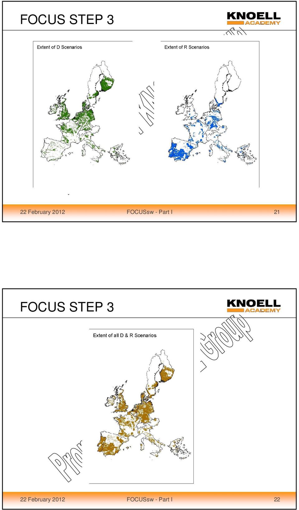
2 FOCUS STEP 3 STEP 1: Single application, one standard scenario STEP 2: Multiple application, two standard scenarios (North and South Europe) STEP 3: 10 realistic worst case scenarios STEP 4: Refined modelling 22 February 2012 FOCUSsw - Part I 3 FOCUS STEP 3 Assumptions in Step 2: Entry routes: spray drift, runoff, drainage Application rate for multiple applications (g/ha) Specification of the season of application Substance properties: DT50 total system, solubility in water, KOC value, DT50 soil, DT50 water, DT50 sediment Use related assumptions: spray drift values for multiple applications, interception valuesous Regional specification: Northern and Southern Europe North South 22 February 2012 FOCUSsw - Part I 4

3 FOCUS STEP 3 Assumptions in Step 3: Entry routes: Spray drift, runoff, drainage Application rate for multiple applications (g/ha) Specification of the season of application and of the chemical application method Substance properties: DT50 total system, solubility in water, KOC value, DT50 soil, DT50 water, DT50 sediment and vapour pressure Use related assumptions: spray drift values for multiple applications, interception values, application window Regional specification of 10 scenarios across Europe 22 February 2012 FOCUSsw - Part I 5 FOCUS STEP 3 FOCUS sw scenarios 10 locations : 6 drainage scenarios 4 runoff scenarios Spray drift occurring at all locations Brimston La Jailliere Lanna Skousbo Vredepeel Weiherbach Porto Roujan Bologna Thiva 22 February 2012 FOCUSsw - Part I 6

4 FOCUS STEP 3 Step 3 : representative field sites D1 D2 D3 D4 D5 D6 R1 R2 R3 R4 Climate Representative Field Site & Weather Station Soil Surface water bodies Landscape Crops 22 February 2012 FOCUSsw - Part I 7 FOCUS Step 3 scenario development 22 February 2012 FOCUSsw - Part I 8

5 FOCUS STEP 3 Representative European Datasets Classify agroenvironmental characteristics according to their relative worst-case nature Overlay datasets and identify realistic options 10 scenarios identified according to the worst-case nature of their inherent agroenvironmental characteristics: Climate Slope Soil Pragmatic choice of 10 realistic combinations in agricultural regions 22 February 2012 FOCUSsw - Part I 9 FOCUS STEP 3 Step 3 scenario development: European datasets Climate average annual precipitation daily maximum spring rainfall average spring and autumn temperatures average annual recharge Landscape characteristics slope soil texture, drainage status and parent material Land cover and cropping 22 February 2012 FOCUSsw - Part I 10

6 FOCUS STEP 3 Step 3 scenario development: Climate Table Climatic temperature classes for differentiating agricultural scenarios Average Autumn & Spring temperature Range C Assessment <6.6 Extreme worst-case Worst case Intermediate case >12.5 Best case FOCUS, February 2012 FOCUSsw - Part I 11 FOCUS STEP 3 Step 3 scenario development: Climate Table Climatic classes for differentiating agricultural drainage and runoff scenarios Average Annual Recharge (drainage) Average Annual Rainfall (Run-off) Range mm Assessment Range mm Assessment >300 Extreme worst case >1000 Extreme worst case Worst case Worst case Intermediate case Intermediate case <100 Best case < 600 Best case FOCUS, February 2012 FOCUSsw - Part I 12

7 FOCUS STEP 3 Step 3 scenario development: Landscape Table Slope classes for differentiating agricultural runoff scenarios Slope (Run-off) Range % Assessment >10 Extreme worst case 4 10 Worst case 2 4 Intermediate case <2 Best case FOCUS, February 2012 FOCUSsw - Part I 13 FOCUS STEP 3 Step 3 scenario development: Soil Table Relative worst-case soil characteristics for Drainage Soil Characteristics Coarsely structured cracking clay soils with extreme by-pass flow on impermeable substrates Clays and heavy loams with by-pass flow over shallow groundwater Sands with small organic matter content over shallow groundwater Light loams with small organic matter content and some by-pass flow on slowly permeable substrates Assessment Extreme worst case Worst case Worst case Intermediate case FOCUS, February 2012 FOCUSsw - Part I 14

8 FOCUS STEP 3 Step 3 scenario development: Soil Table Relative worst-case soil characteristics for Runoff Soil Characteristics Soil hydrologic group D 1 (heavy clay soils) Soil hydrologic group C 1 (silty or medium loamy soils with low organic matter content). Soil hydrologic group B 1 (light loamy soils with small clay and moderate organic matter content) Assessment Extreme worst case Worst case Intermediate case 1 Descriptions of soil hydrologic groups are according to the PRZM manual (Carsel et al, 1995) FOCUS, February 2012 FOCUSsw - Part I 15 FOCUS STEP 3 10 representative field sites were identified D1 Lanna (Sweden) D2 Brimstone (UK) D3 Vredepel (Belgium) D1 D4 Skousbo (Denmark) D4 D5 La Jaillere (France) D2 D3 D6 Thiva (Greece) D5 R1 R1 Weiherbach (Germany) R2 Porto (Portugal) R3 Bologna (Italy) R2 R4 R3 R4 Roujan (France) D6 22 February 2012 FOCUSsw - Part I 16
 Assessment Extreme worst case Worst case Intermediate case 1 Descriptions of soil hydrologic groups")
9 FOCUS STEP 3 Step 3 scenarios: 22 February 2012 FOCUSsw - Part I 17 FOCUS STEP 3 Step 3 scenarios: 22 February 2012 FOCUSsw - Part I 18

10 FOCUS STEP 3 Step 3 scenarios: Name Mean annual Temp. ( C) Annual Rainfall (mm) Topsoil Organic matter (%) Slope (%) Water bodies Weather station D Silty clay Ditch, stream Lanna D Clay Ditch, stream Brimstone D Sand Ditch Vredepeel D Loam Pond, Stream Skousbo D Loam Pond, stream La Jailliere D Clay loam Ditch Thiva R Silt loam Pond, stream Weiherbach R Sandy loam 4 20* Stream Porto R Clay loam 1 10* Stream Bologna R Sandy clay loam Stream Roujan * = terraced to 5%. D2: represents a 99.3 percentile worst case for all drained agricultural land R2: represents a 98 percentile worst case for all agriculrual runoff land 22 February 2012 FOCUSsw - Part I 19 FOCUS STEP 3 22 February 2012 FOCUSsw - Part I 20

11 FOCUS STEP 3 22 February 2012 FOCUSsw - Part I 21 FOCUS STEP 3 22 February 2012 FOCUSsw - Part I 22
12 FOCUS STEP 3 Crop and management parameters a Carrot chosen as representative B Cabbage chosen as representative C Onion chosen as representative D Peas chosen as representative E Tomatoes chosen as representative F Apple chosen as representative G 70 th percentile wettest weather data use 22 February 2012 FOCUSsw - Part I 23 Regulatory Affairs Product Safety ConsultingI Irrigation Training used FOCUS Step 3 water bodies 22 February 2012 FOCUSsw - Part I 24

13 FOCUS STEP 3 water bodies edge of field surface water bodies were identified for each of the selected 10 scenarios absence of data bases mapping the characteristics of surface water bodies over Europe expert judgement was used to identify three categories of edge of field surface water body that are common in Europe Pond: static or slow moving Ditch: relatively slow moving First order stream: fast moving 22 February 2012 FOCUSsw - Part I 25 FOCUS STEP 3 water bodies Presence or absence of these categories of water body at eahc site was assessed from local knowledge and validated by examining detailed fiedscale maps of the relevant areas. 22 February 2012 FOCUSsw - Part I 26

14 FOCUS STEP 3 Charachteristics of the water bodies In order to parameterise each water body as set of characteristics relating to the dimensions, sediment and organic components and hydrology are required Of these characteristics, the water body dimensions and sediment and organic components were fixed for each water body type irrespective of the scenario Dimensions Type of water body Width (m) Total length (m) Distance from top of bank to water (m) Ditch Pond Stream February 2012 FOCUSsw - Part I 27 FOCUS STEP 3 Charachteristics of the water bodies Sediment and Organic components Identical to Steps 1&2 The sediment layer represents a relatively vulnerable sediment layer in agricultural areas and its properties are based on experimental data. No macrophytes (the calculated exposure concentrations are tend to be conservative; macrophytes tend to adsorb pesticides Characteristic Value Concentration of suspended solids in water column (mg.l -1 ) 15 Sediment layer depth (cm) 5 Organic carbon content (%) 5 (approx. 9% organic matter) Dry bulk density (kg.m -3 ) 800 Porosity (%) February 2012 FOCUSsw - Part I 28

15 FOCUS STEP 3 Charachteristics of the water bodies Hyrology Surface water body Average water depth (m) Average residence time (days) Pond Ditch Stream 0.3 to flows within any water body are dynamic, reflecting the various base flow, runoff and drainage responses to rainfall events in the water body s catchments. To characterise such flow dynamics the concept of Hydraulic residence time was used with the following definition: τ = V/Q τ = hydraulic residence time (d) V = volume of water body considered (m3) Q = discharge flowing out of water body (m3/d) 22 February 2012 FOCUSsw - Part I 29 FOCUS STEP 3 Ditch Pond 4500 m 2 field treated with pesticide Input from drainage or runoff (pesticide) plus base flow (no pesticide) 100 m 2 hectare field, not treated Input from drainage and base flow (no pesticide) 1 hectare field treated with pesticide Input from drainage only Stream Eroded sediment (+ pesticide) input from a 20 m contributing margin along stream (runoff scenarios only) Pond Pond outflow regulated by a 1.0 m high weir with a 0.5 m wide crest 100 ha upstream catchment. 20 % treated with pesticide Eroded sediment (+ pesticide) input from a 20 m margin along one side of pond (runoff scenarios only) Entries from the catchment Drainage or runoff (pesticide) plus baseflow (no pesticide) No sediment input 100 m 1 ha field treated with pesticide Input from drainage or runoff 22 February 2012 FOCUSsw - Part I 30
 22 February 2012 FOCUSsw - Part I 29 FOCUS STEP 3 Ditch Pond 4500 m 2 field treated with pesticide Input from drainage or runoff (pesticide) plus base")
16 FOCUS STEP 3 22 February 2012 FOCUSsw - Part I 31 FOCUS STEP 3 22 February 2012 FOCUSsw - Part I 32

17 FOCUS STEP 3 22 February 2012 FOCUSsw - Part I 33 FOCUS STEP 3 Standard buffers between crop and surface water body are used in Step 1, 2 and 3 (defined by the FOCUS surface water workgroup ) Spray drift values used in each STEP are determined by: Step 1 Crop Number of applications Step 2 x x x Type of water body Step 3 x x x 22 February 2012 FOCUSsw - Part I 34

18 FOCUS STEP 3 Water body Step 1&2 1 : cm 5 cm; 5% oc BD = 0.8 Standard assumptions for water body and sediment Water depth (cm): 30 Sediment depth (cm): 5 Sediment OC (%): 5 Sed. bulk density (g/ml): 0.8 Ratio of field:water body: 10 Effective sediment depth = 1cm 22 February 2012 FOCUSsw - Part I 35 FOCUS STEP 3 water body at Step 3 Crop specific: from 0.5m to 5m Distance from crop to far edge of water Distance from crop to near edge of water Distance from crop to top of bank Distance from top of bank to water Width of water body Integrated width of the water body Water bodies: 0.5 m (ditch) / 1 m (stream) / 3 m (pond) 22 February 2012 FOCUSsw - Part I 36

19 FOCUS STEP 3 water body at Step 3 For each class a default distance from edge of the treated field to the top bank of the water body was defined. Distance range from 0.5 m to 3 m for ground applications and 5 m for aerial applications. The horizontal distance from the top of the bank to the water body is specific to each type and was defined as 0.5 m for ditches, 1.0 m for streams and 3.0 m for ponds. 22 February 2012 FOCUSsw - Part I 37 FOCUS STEP 3 Application methods: ground spray air blast soil incorporated granular aerial application 22 February 2012 FOCUSsw - Part I 38

20 FOCUS STEP 3 Application methods: ground spray (spray drift) air blast (spray drift) soil incorporated (no drift) granular (no drift) aerial application (spray drift) 22 February 2012 FOCUSsw - Part I 39 FOCUS STEP 3 22 February 2012 FOCUSsw - Part I 40

21 FOCUS STEP 3 Chemical application method (CAM): determines how the substance is distributed in the soil CAM1: application to soil, linear decline in soil CAM2: application to plant, linear decline in soil... CAM8: application at a user specified depth 22 February 2012 FOCUSsw - Part I 41 FOCUS STEP 3 22 February 2012 FOCUSsw - Part I 42
22 FOCUS Step 3 Tools 22 February 2012 FOCUSsw - Part I FOCUS SWASH ALL SCENARIOS 2. FOCUS Spray Drift Calculator DRAINAGE SCENARIOS 3. FOCUS MACRO RUNOFF SCENARIOS 4. FOCUS PRZM 5. FOCUS TOXSWA 6. Output file 22 February 2012 FOCUSsw - Part I 44
23 General procedure: All scenario, use and substance definitions are made by the user in the SWASH shell SWASH generates specific input files for each of the models (MACRO, PRZM TOXSWA) MACRO and PRZM are started by the user and run independently from each other TOXSWA combines the output from either MACRO + Drift calculator (drainage) or PRZM + Drift calculator (runoff) and generates output files for each of the surface water scenarios 22 February 2012 FOCUSsw - Part I 45 Runoff model: PRZM Drainage model: MACRO Leaching model, used to simulate runoff and erosion pathway simulation with 2 metabolites possible Leaching model, used to simulate drainflow, includes preferential flow pathway simulation with 1 single metabolite possible 22 February 2012 FOCUSsw - Part I 46
 Vines (late) Pond 0.22 % 4.73 % 0.61 % Ditch 1.98 % 23.6 % 5.17 % Stream 1.43 % 21.6 % 4.")
24 FOCUS Drift calculator Calculates areic mean drift rates depending on Crop Number of applications Type of water body 22 February 2012 FOCUSsw - Part I 47 Drift rates in FOCUS Step 3 Example: areic mean drift rates for a single application Cereals Pome fruit (early) Vines (late) Pond 0.22 % 4.73 % 0.61 % Ditch 1.98 % 23.6 % 5.17 % Stream 1.43 % 21.6 % 4.29 % 22 February 2012 FOCUSsw - Part I 48
25 Application Timing Application timing has an influence on Predicted environmental concentrations Pesticide losses via runoff or drainage are event driven strongly depend on climate conditions following the application PAT (Pesticide Applicatio Tool) 22 February 2012 FOCUSsw - Part I 49 PAT Pesticide Application Tool The PAT calculator eliminates a significant number of potential application dates due to the requirement that at least 10 mm of precipitation be received within ten days following application. This criteria in the PAT calculator results in selection of application dates. PAT minimises the user influence on the application date and on the results of the Step 3 calculations 22 February 2012 FOCUSsw - Part I 50
26 PAT Pesticide Application Tool User input: Number of applications Minimum application interval First possible date of application Days in the application window The minimum application window is defined as: Application window = 30 + (Number of aplications-1) * Interval 22 February 2012 FOCUSsw - Part I 51 PAT Pesticide Application Tool Criteria for the selection of a specific application date: At least 10 mm of precipitation (cumulative) should occur within 10 days of an application No more than 2 mm/day of precipitation should occur on any day within a 5-day period starting two days before application If no dates are found in the meteorological files that meet these criteria, the precipitation targets and timing in the two rules are progressively relaxed until acceptable application dates are found 22 February 2012 FOCUSsw - Part I 52
27 Surface water fate model: TOXSWA fate modelling in the surface water body Integrates inputs from MACRO (drainage) or PRZM (runoff) and the spray drift deposition calculated by the spray drift calculator Does not simulate formation of metabolites 22 February 2012 FOCUSsw - Part I 53 Manual of FOCUS_TOXSWA Version (Alterra rapport 586) 22 February 2012 FOCUSsw - Part I 54
28 Total simulation period: MACRO: 6 years PRZM: 20 years TOXSWA: 12 months (R-scenarios) 16 months (D-scenarios) Total run time: ca. 30 minutes per individual run e.g. winter cereals (14 individual runs): ca. 7 hours 22 February 2012 FOCUSsw - Part I 55 FOCUS Step 3 Step by Step 22 February 2012 FOCUSsw - Part I 56
29 Swash shell 22 February 2012 FOCUSsw - Part I February 2012 FOCUSsw - Part I 58

30 22 February 2012 FOCUSsw - Part I February 2012 FOCUSsw - Part I 60

31 Phys-chem parameter 22 February 2012 FOCUSsw - Part I 61 Sorption parameter 22 February 2012 FOCUSsw - Part I 62


32 Default values for plant uptake and wash-off 22 February 2012 FOCUSsw - Part I 63 Degradation parameter 22 February 2012 FOCUSsw - Part I 64
33 22 February 2012 FOCUSsw - Part I 65 Create a new project: 22 February 2012 FOCUSsw - Part I 66
34 Create: Project name Description Choose Substance data crop 22 February 2012 FOCUSsw - Part I 67 Define applications: 22 February 2012 FOCUSsw - Part I 68

35 22 February 2012 FOCUSsw - Part I 69 D-Scenario Use pattern: Application method Number of applications First possible application date Number of days for the application window Application interval Application rate 22 February 2012 FOCUSsw - Part I 70
36 R-Scenario Chemical Application Model (CAM): Soil linear (on the soil) Foliar linear (on the plant) 22 February 2012 FOCUSsw - Part I 71 Create input data: 22 February 2012 FOCUSsw - Part I 72
37 The PRZM Shell: 22 February 2012 FOCUSsw - Part I February 2012 FOCUSsw - Part I 74
38 22 February 2012 FOCUSsw - Part I 75 Choose of SWASH-Project 22 February 2012 FOCUSsw - Part I 76


39 February 2012 FOCUSsw - Part I 77 The results are automatically transferred to TOXSWA. 22 February 2012 FOCUSsw - Part I 78
40 The MACRO Shell: 22 February 2012 FOCUSsw - Part I February 2012 FOCUSsw - Part I 80
.")

41 Choose of crop and scenario (Drainage). 22 February 2012 FOCUSsw - Part I 81 Choose of the substance 22 February 2012 FOCUSsw - Part I 82

42 22 February 2012 FOCUSsw - Part I 83 Choose of the application scheme of the project February 2012 FOCUSsw - Part I 84


43 22 February 2012 FOCUSsw - Part I February 2012 FOCUSsw - Part I 86
44 2. Choose RUNID 1. Choose crop 3. Transfer of results to TOXSWA 22 February 2012 FOCUSsw - Part I 87 The TOXSWA Shell: 22 February 2012 FOCUSsw - Part I 88


45 22 February 2012 FOCUSsw - Part I 89 Choose for graphical output 22 February 2012 FOCUSsw - Part I 90
46 22 February 2012 FOCUSsw - Part I 91 Report-File 22 February 2012 FOCUSsw - Part I 92
47 Report-File 22 February 2012 FOCUSsw - Part I 93 TOXSWA output: Hourly concentrations within the total simulation period TOXSWA evaluation: Global maximum concentration Maximum of all peaks within the total simulation period Actual concentrations Actual concentrations after the global maximum Time-weighted average concentrations Maximum of average concentrations over a certain time period (e.g. 7 days) after the global maximum 22 February 2012 FOCUSsw - Part I 94


48 Got to Run-ID_pa.sum 22 February 2012 FOCUSsw - Part I February 2012 FOCUSsw - Part I 96
49 Additional information Date of application Rate of application Spray drift rate 22 February 2012 FOCUSsw - Part I 97 Date of max. PECsw 22 February 2012 FOCUSsw - Part I 98
50 Date of max. PECsed 22 February 2012 FOCUSsw - Part I 99 Identification of the main entry route in Step 3: Day of application = Day of max. concentration Main entry route: spray drift Day of application Day of max. concentration Main entry route: drainage (D-scenarios) Main entry route: runoff (R-scenarios) 22 February 2012 FOCUSsw - Part I 100
51 SWASH Excercise - Teil 1: GAP: 3 applications with 0.75 kg/ha in pome and stone fruits application interval: 7 days BBCH (Start application window: 1. April) (Day 91) E-Fate Parameter: Molar Mass: 300 g/mol Vapour pressure: 9.9E-9 Pa Water solubility: 2.00 mg/l K FOC -Wert: 1000 L/kg Freundlich Exponent: 0.9 DT 50 soil: DT 50 water: 1.5 days 0.50 days Create substance create use patttern => Run PRZM, Run TOXSWA (R-Scenarios) => Ergebnisse: PECsw (act, twa), PECsed (act, twa), Main entry pathway DT 50 sediment: 8.00 days 22 February 2012 FOCUSsw - Part I 101 Results: PECsw (µg/l) PECsed (µg/kg) Main entry R1s Spray R1p Spray R2s Spray R3s Spray R4s Spray 22 February 2012 FOCUSsw - Part I 102
WOt. werkdocumenten. SWASH Manual 2.1. User s Guide version 2. F. van den Berg P.I. Adriaanse J. A. te Roller V.C. Vulto J.G.
 83 SWASH Manual 2.1 User s Guide version 2 F. van den Berg P.I. Adriaanse J. A. te Roller V.C. Vulto J.G. Groenwold werkdocumenten WOt Wettelijke Onderzoekstaken Natuur & Milieu SWASH Manual 2.1 User
4. DEMO AND EXERCISES
 4. DEMO AND EXERCISES FROGS (French Refinement Of Groundwater Scenarios) UIPP Training Paris, 16 November 2011 UIPP Environmental Methodology Working Group Outline 1. Introduction to FROGS GUI Create FROGS
Tier-1 and Tier-2A Scenario Parameterisation and Example Calculations 1
 EFSA Journal 2012;10(1):2433 SCIENTIFIC REPORT OF EFSA Tier-1 and Tier-2A Scenario Parameterisation and Example Calculations 1 In Support of the Revision of the Guidance Document on Persistence in Soil
SUSTAINABLE URBAN DRAINAGE SYSTEMS
 overflow can lead into a permeable conveyance system to increase further the benefit and reduce the need for pipe systems. Pollutant removal rates have been shown to be high, with some pollutants being
Chapter D9. Irrigation scheduling
 Chapter D9. Irrigation scheduling PURPOSE OF THIS CHAPTER To explain how to plan and schedule your irrigation program CHAPTER CONTENTS factors affecting irrigation intervals influence of soil water using
WILLOCHRA BASIN GROUNDWATER STATUS REPORT 2009-10
 WILLOCHRA BASIN GROUNDWATER STATUS REPORT 2009-10 SUMMARY 2009-10 The Willochra Basin is situated in the southern Flinders Ranges in the Mid-North of South Australia, approximately 50 km east of Port Augusta
How To Model Algae Population Growth
 Measuring and predicting the effects of time-variable exposure of pesticides on populations of green algae: Combination of flow-through studies and ecological modelling as an innovative tool for refined
Applying MIKE SHE to define the influence of rewetting on floods in Flanders
 Applying MIKE SHE to define the influence of rewetting on floods in Flanders MARK HENRY RUBARENZYA 1, PATRICK WILLEMS 2, JEAN BERLAMONT 3, & JAN FEYEN 4 1,2,3 Hydraulics Laboratory, Department of Civil
WATER QUALITY MONITORING AND APPLICATION OF HYDROLOGICAL MODELING TOOLS AT A WASTEWATER IRRIGATION SITE IN NAM DINH, VIETNAM
 WATER QUALITY MONITORING AND APPLICATION OF HYDROLOGICAL MODELING TOOLS AT A WASTEWATER IRRIGATION SITE IN NAM DINH, VIETNAM LeifBasherg (1) OlujZejlllJul Jessen (1) INTRODUCTION The current paper is the
DESCRIPTION OF STORMWATER STRUCTURAL CONTROLS IN MS4 PERMITS
 DESCRIPTION OF STORMWATER STRUCTURAL CONTROLS IN MS4 PERMITS Phase I MS4 permits require continuous updating of the stormwater system inventory owned and operated by the MS4. They also include inspection
APPENDIX B CHARACTERIZATION OF SOILS AT TEST SITES
 APPENDIX B HARATERIZATION OF SOILS AT TEST SITES A.1 LAMBTON FAILITY 2015 ANNUAL LANDFILL REPORT BIOMONITORING PROGRAM pendix B haracterization of Soils at Test Sites pendix B HARATERIZATION OF SOILS
Universal Soil Erosion Equation
 Author: Laura Swantek Time: 50 minute class period Grade Level: 9-12 Background: Soil is created by the weathering of rock and the decomposition of organic materials. Soils are classified according to
WATER CONSERVATION TECHNICAL BRIEFS
 WATER CONSERVATION TECHNICAL BRIEFS TB 2 Rainwater Harvesting and Artificial Recharge to Groundwater SAI Platform August 2009 This document has been produced for internal information purposes only among
Flash Flood Science. Chapter 2. What Is in This Chapter? Flash Flood Processes
 Chapter 2 Flash Flood Science A flash flood is generally defined as a rapid onset flood of short duration with a relatively high peak discharge (World Meteorological Organization). The American Meteorological
Europe s Application Monitoring and Equipment Verification
 The 8th Annual Pesticide Stewardship Conference Asheville, North Carolina Europe s Application Monitoring and Equipment Verification Dirk Rautmann Julius Kühn-Institute Federal Research Institute for Cultivated
Influence of Climatic Factors on Stormwater Runoff Reduction of Green Roofs
 Influence of Climatic Factors on Stormwater Runoff Reduction of Green Roofs North Temperate Zone Greenskins Lab Runoff Retention / Precipitation (Annual %) Vancouver, BC 29% Malmö, Sweden 47 % Rock Springs,
GUIDELINES FOR SOIL FILTER MEDIA IN BIORETENTION SYSTEMS (Version 2.01) March 2008
 March 2008") GUIDELINES FOR SOIL FILTER MEDIA IN BIORETENTION SYSTEMS (Version 2.01) March 2008 The following guidelines for soil filter media in bioretention systems have been prepared on behalf of the Facility for
GUIDELINES FOR SOIL FILTER MEDIA IN BIORETENTION SYSTEMS (Version 2.01) March 2008 The following guidelines for soil filter media in bioretention systems have been prepared on behalf of the Facility for
6. Base your answer to the following question on the graph below, which shows the average monthly temperature of two cities A and B.
 1. Which single factor generally has the greatest effect on the climate of an area on the Earth's surface? 1) the distance from the Equator 2) the extent of vegetative cover 3) the degrees of longitude
SWAT INPUT DATA:.GW CHAPTER 24
 CHAPTER 24 SWAT INPUT DATA:.GW SWAT partitions groundwater into two aquifer systems: a shallow, unconfined aquifer which contributes return flow to streams within the watershed and a deep, confined aquifer
A SOIL TESTING SERVICE FOR FARMERS IN THAILAND, USING MOBILE LABORATORIES
 A SOIL TESTING SERVICE FOR FARMERS IN THAILAND, USING MOBILE LABORATORIES Narong Chinabut Office of Science for Land Development Land Development Department, Ministry of Agriculture and Cooperatives, Bangkok
Origins and causes of river basin sediment degradation and available remediation and mitigation options. Feedback from the Riskbase workshop
 Origins and causes of river basin sediment degradation and available remediation and mitigation options Feedback from the Riskbase workshop Corinne Merly 1, Olivier Cerdan 1, Laurence Gourcy 1 Emmanuelle
BLACK/HARMONY/FAREWELL CREEK WATERSHED EXISTING CONDITIONS REPORT CHAPTER 12 - STORMWATER MANAGEMENT
 Harmony Creek subwatershed Harmony Creek subwatershed BLACK/HARMONY/FAREWELL CREEK WATERSHED EXISTING CONDITIONS REPORT CHAPTER 12 - STORMWATER MANAGEMENT April 2011 TABLE OF CONTENTS 1.0 INTRODUCTION...
AERIAL PLANT PROTECTION WORK IN AGRICULTURE IN HUNGARY (Sent to OECD as national proposal to make best practice for pesticide aerial application)
") AERIAL PLANT PROTECTION WORK IN AGRICULTURE IN HUNGARY (Sent to OECD as national proposal to make best practice for pesticide aerial application) I. Historical background In Hungary, aerial application
AERIAL PLANT PROTECTION WORK IN AGRICULTURE IN HUNGARY (Sent to OECD as national proposal to make best practice for pesticide aerial application) I. Historical background In Hungary, aerial application
Catchment Scale Processes and River Restoration. Dr Jenny Mant [email protected]. The River Restoration Centre therrc.co.uk
 Catchment Scale Processes and River Restoration Dr Jenny Mant [email protected] The River Restoration Centre therrc.co.uk 3 Main Catchment Elements Hydrology Energy associated with the flow of water affects
WATER AND DEVELOPMENT Vol. II - Types Of Environmental Models - R. A. Letcher and A. J. Jakeman
 TYPES OF ENVIRONMENTAL MODELS R. A. Letcher and A. J. Jakeman Centre for Resource and Environmental Studies, The Australian National University, Australia Keywords: environmental models, environmental
Hydrologic Soil Groups
 United States Department of Agriculture Natural Resources Conservation Service Hydrology Chapter 7 Rain clouds Cloud formation Precipitation Transpiration Surface runoff Evaporation from vegetation Transpiration
Abaya-Chamo Lakes Physical and Water Resources Characteristics, including Scenarios and Impacts
 LARS 2007 Catchment and Lake Research Abaya-Chamo Lakes Physical and Water Resources Characteristics, including Scenarios and Impacts Seleshi Bekele Awulachew International Water Management Institute Introduction
AZ EGER-PATAK HIDROLÓGIAI VIZSGÁLATA, A FELSZÍNI VÍZKÉSZLETEK VÁRHATÓ VÁLTOZÁSÁBÓL ADÓDÓ MÓDOSULÁSOK AZ ÉGHAJLATVÁLTOZÁS HATÁSÁRA
 AZ EGER-PATAK HIDROLÓGIAI VIZSGÁLATA, A FELSZÍNI VÍZKÉSZLETEK VÁRHATÓ VÁLTOZÁSÁBÓL ADÓDÓ MÓDOSULÁSOK AZ ÉGHAJLATVÁLTOZÁS HATÁSÁRA GÁBOR KEVE 1, GÉZA HAJNAL 2, KATALIN BENE 3, PÉTER TORMA 4 EXTRAPOLATING
Computing Stormwater Runoff Rates and Volumes
 New Jersey Stormwater Best Management Practices Manual February 2004 C H A P T E R 5 Computing Stormwater Runoff Rates and Volumes This chapter discusses the fundamentals of computing stormwater runoff
WEPP MODEL APPLICATIONS FOR EVALUATIONS OF BEST MANAGEMENT PRACTICES
 WEPP MODEL APPLICATIONS FOR EVALUATIONS OF BEST MANAGEMENT PRACTICES D.C. FLANAGAN 1, W.J. ELLIOT 2, J.R. FRANKENBERGER 3, C. HUANG 4 1 USDA-Agricultural Research Service, National Soil Erosion Research
Review of TOPPS project
 Review of TOPPS project Train Operators to Promote best Practices & Sustainability Achievements to date 1 st April 2015 Inge Mestdagh & Thierry Schoonejans Dow AgroSciences - ECPA TOPPS is a longterm committment
A Developer s Guide: Watershed-Wise Development
 A Developer s Guide: Watershed-Wise Development Environmental Protection What is a watershed? It does not matter how far away you build from a creek, lake, or the ocean, you are in a watershed. Another
Optimizing the hydraulic designing of pressurized irrigation network on the lands of village Era by using the computerized model WaterGems
 Optimizing the hydraulic designing of pressurized irrigation network on the lands of village Era by using the computerized model WaterGems Ali Ghadami Firouzabadi 1 and Majid Arabfard 2 1. Ali Ghadami
Investigator: David R. S. Rourke. General Trial Information
 02 Nov 2011 (PowerRich Potato 2011 EC) Site Description Page 1 of 9 Trial ID: PR151-MWA Location: ELM CREEK, MB Protocol ID: Study Director: Trent Knight Investigator: David R. S. Rourke General Trial
Watershed Works Manual
 National Rural Employment Guarantee Act Watershed Works Manual DRAINAGE LINE TREATMENT: GABION STRUCTURE Baba Amte Centre for People s Empowerment Samaj Pragati Sahayog September 2006 Drainage Line Treatment:
European Conference on Safe Use of Plant Protection Products
 European Conference on Safe Use of Plant Protection Products Conference Report, 18 June 2014 In June 2014, the Federal Institute for Risk Assessment in Germany (BfR) and the European Commission hosted
Interlocking Concrete Pavement Institute (ICPI) Model Stormwater Ordinance for Permeable Interlocking Concrete Pavements August 2010
 Model Stormwater Ordinance for Permeable Interlocking Concrete Pavements August 2010") Interlocking Concrete Pavement Institute (ICPI) Model Stormwater Ordinance for Permeable Interlocking Concrete Pavements August 2010 Background What are permeable interlocking concrete pavements (PICP)?
Interlocking Concrete Pavement Institute (ICPI) Model Stormwater Ordinance for Permeable Interlocking Concrete Pavements August 2010 Background What are permeable interlocking concrete pavements (PICP)?
Storm Drain Inlet Protection for Construction Sites (1060)
") Storm Drain Inlet Protection for Construction Sites (1060) Wisconsin Department of Natural Resources Conservation Practice Standard I. Definition A temporary device installed in or around a storm drain
Storm Drain Inlet Protection for Construction Sites (1060) Wisconsin Department of Natural Resources Conservation Practice Standard I. Definition A temporary device installed in or around a storm drain
Waterway Technote Drains
 Waterway Technote Drains Contents Benefits of good drain practice 1 Are your drains healthy? 2 The Sustainable Dairying Water Accord 3 Planning drain maintenance 3 Fencing and clearing 3 Bank shaping (battering)
Pervious Pavers. By: Rich Lahren. Hebron Brick & Block Supply
 Pervious Pavers By: Rich Lahren Hebron Brick & Block Supply Stormwater Management and Control Issues Past emphasis was on flood control Today s emphasis is also on pollution More impermeable areas are
WETLAND RESTORATION PROGRAM WATER ACT APPROVAL ADMINISTRATIVE GUIDE
 WETLAND RESTORATION PROGRAM WATER ACT APPROVAL ADMINISTRATIVE GUIDE May 24, 2005 Table of Contents Introduction...3 Definitions...3 Types of Wetland Restorations...4 Re-Contouring...4 Engineered...4 Water
COTTON WATER RELATIONS
 COTTON WATER RELATIONS Dan R. Krieg 1 INTRODUCTION Water is the most abundant substance on the Earth s surface and yet is the most limiting to maximum productivity of nearly all crop plants. Land plants,
The Hydrologic Cycle. precipitation evaporation condensation transpiration infiltration surface runoff transport groundwater water table.
 The Hydrologic Cycle Page 1 of 1 Name Directions: The hydrologic cycle consists of the processes that change and move water through the earth s system. Use the terms below to label the hydrologic cycle.
What is Soil Survey?
 What is Soil Survey? Soil Survey is a systematic examination, description, classification, and mapping of the soils in a given area. Brady and Weil. 1996 Who Produces Soil Survey Cooperative effort between
Guidance on the use of sustainable drainage systems (SUDS) and an overview of the adoption policy introduced by
 and an overview of the adoption policy introduced by") Guidance on the use of sustainable drainage systems (SUDS) and an overview of the adoption policy introduced by Easy guide to Sustainable drainage systems 02 Contents Page Introduction 05 Purpose of this
Guidance on the use of sustainable drainage systems (SUDS) and an overview of the adoption policy introduced by Easy guide to Sustainable drainage systems 02 Contents Page Introduction 05 Purpose of this
Adapt-N Guided Hands-on Exercise
 Adapt-N Guided Hands-on Exercise Pointers: Use Mozilla Firefox as your browser. Do not use the BACK button. Make sure to input your locations as 2012 locations (not 2013). Make sure to input a Season End
CHAPTER 2 HYDRAULICS OF SEWERS
 CHAPTER 2 HYDRAULICS OF SEWERS SANITARY SEWERS The hydraulic design procedure for sewers requires: 1. Determination of Sewer System Type 2. Determination of Design Flow 3. Selection of Pipe Size 4. Determination
9.00 THE USE OF HUNTER LAND DRAINAGE PERFORATED PIPES. Hunter Underground Systems
 9.00 THE USE OF HUNTER LAND DRAINAGE PERFORATED PIPES Hunter Underground Systems 9.01 General 9.02 Surface water Drainage 9.03 Groundwater Drainage 9.04 Dispersal of Septic Tank Effluent 9.01 The use of
Review of Groundwater Vulnerability Assessment Methods Unsaturated Zone. Dept. of Earth Sciences University of the Western Cape
 Review of Groundwater Vulnerability Assessment Methods Unsaturated Zone Dept. of Earth Sciences University of the Western Cape Background Sililo et al. (2001) Groundwater contamination depends on: Intrinsic
Soil Cleanup Goals. Minnesota Department of Agriculture Pesticide and Fertilizer Management Division. Guidance Document 19
 This document is made available electronically by the Minnesota Legislative Reference Library as part of an ongoing digital archiving project. http://www.leg.state.mn.us/lrl/lrl.asp Minnesota Department
NC STATE UNIVERSITY PERMEABLE PAVEMENT RESEARCH AND CHANGES TO THE STATE OF NC RUNOFF CREDIT SYSTEM
 NC STATE UNIVERSITY PERMEABLE PAVEMENT RESEARCH AND CHANGES TO THE STATE OF NC RUNOFF CREDIT SYSTEM William F. Hunt, III and Eban Z. Bean William F. Hunt, Biological and Agricultural Engineering, NC State
Emergency Spillways (Sediment basins)
") Emergency Spillways (Sediment basins) DRAINAGE CONTROL TECHNIQUE Low Gradient Velocity Control Short-Term Steep Gradient Channel Lining Medium-Long Term Outlet Control Soil Treatment Permanent [1] [1]
Emergency Spillways (Sediment basins) DRAINAGE CONTROL TECHNIQUE Low Gradient Velocity Control Short-Term Steep Gradient Channel Lining Medium-Long Term Outlet Control Soil Treatment Permanent [1] [1]
Sustainable Drainage Systems (SUDS) A guide for developers
 A guide for developers") Sustainable Drainage Systems (SUDS) A guide for developers We are the Environment Agency. It s our job to look after your environment and make it a better place for you, and for future generations. Your
Sustainable Drainage Systems (SUDS) A guide for developers We are the Environment Agency. It s our job to look after your environment and make it a better place for you, and for future generations. Your
LYNDE CREEK WATERSHED EXISTING CONDITIONS REPORT CHAPTER 12 - STORMWATER MANAGEMENT
 Whitby CLOCA Whitby CLOCA LYNDE CREEK WATERSHED EXISTING CONDITIONS REPORT CHAPTER 12 - STORMWATER MANAGEMENT June 2008 TABLE OF CONTENTS 1.0 INTRODUCTION... 3 2.0 STUDY AREA AND SCOPE... 4 3.0 METHODOLOGY...
APPENDIX F. RESIDENTIAL WATER QUALITY PLAN: ALLOWABLE BMP OPTIONS
 APPENDIX F. RESIDENTIAL WATER QUALITY PLAN: ALLOWABLE BMP OPTIONS The following section provides descriptions, advantages, limitations, and schematics of allowable best management practices (BMPs) for
Pervious Pavers: Where is the Perviousness?
 Pervious Pavers: Where is the Perviousness? Elizabeth (Betsy) Pappas Research Hydraulic Engineer Chi-hua Huang Soil Scientist United States Department of Agriculture Agricultural Research Service National
Outlet stabilization structure
 Overview of Sedimentation and Erosion Control Practices Practice no. 6.41 Outlet stabilization structure Erosion at the outlet of channels, culverts, and other structures is common, and can cause structural
Figure 1.1 The Sandveld area and the Verlorenvlei Catchment - 2 -
 Figure 1.1 The Sandveld area and the Verlorenvlei Catchment - 2 - Figure 1.2 Homogenous farming areas in the Verlorenvlei catchment - 3 - - 18 - CHAPTER 3: METHODS 3.1. STUDY AREA The study area, namely
Course Plan Day 1: Introduction and Overview Hydrology & Fluvial Geomorphology Day 2: Fieldwork on the Braid Burn Alan Jones
 Course Plan Day 1: Introduction and Overview Hydrology & Fluvial Geomorphology Alan Jones E:mail: [email protected] Water cycle Globally & Locally River shapes and forms River behaviour Closer look at
BEACH NOURISHMENT COMBINED WITH SIC VERTICAL DRAIN IN MALAYSIA.
 BEACH NOURISHMENT COMBINED WITH SIC VERTICAL DRAIN IN MALAYSIA. Claus Brøgger 1 and Poul Jakobsen 2 The present paper presents measurements and results from a three year full scale Pilot Project with the
Vulnerability Assessment
 Vulnerability Assessment VULNERABILITY As used in this report, vulnerability refers to the sensitivity of groundwater to contamination, and is determined by intrinsic characteristics of the aquifer. It
BMP 6.7.3: Soil Amendment & Restoration
 BMP 6.7.3: Soil Amendment & Restoration Soil amendment and restoration is the process of improving disturbed soils and low organic soils by restoring soil porosity and/or adding a soil amendment, such
Please click on the tutorial most fitting of your expertise in order to learn about the features of the visualization tool.
 Introduction Welcome to the Indian Creek Conservation Reserve Program (CRP) visualization tool. This tool was developed by the University of Iowa - Institute for Hydroscience and Research (IIHR) as part
Underground Injection Control Storm Water Information
 Underground Injection Control Storm Water Information Best Management Practices DEQ has reviewed the EPA definition of a subsurface fluid distribution system and the infiltration design best management
Module 6 : Quantity Estimation of Storm Water. Lecture 6 : Quantity Estimation of Storm Water
 1 P age Module 6 : Quantity Estimation of Storm Water Lecture 6 : Quantity Estimation of Storm Water 2 P age 6.1 Factors Affecting the Quantity of Stormwater The surface run-off resulting after precipitation
Sewerage Management System for Reduction of River Pollution
 Sewerage Management System for Reduction of River Pollution Peter Hartwig Germany Content page: 1 Introduction 1 2 Total emissions 3 3 Discharge from the wastewater treatment plants 4 4 Discharge from
Environmental Stewardship. Producing a Soil Management Plan for Environmental Stewardship
 Producing a Soil Management Plan for Environmental Stewardship RDS is part of the Department for Environment, Food and Rural Affairs Introduction Well managed soils are an important element of sustainable
A Guide to Specifying Reed Beds and Constructed Wetland Systems
 NIRBC The Northern Ireland Reed Bed Company. Constructed Wetlands for Northern Ireland A Guide to Specifying Reed Beds and Constructed Wetland Systems A Summary for Consultants, Engineers and Architects
4. Environmental Impacts Assessment and Remediation Targets
 4. Environmental Impacts Assessment and Remediation Targets 4.1 Environmental Impacts Significant additional development in the Alder Creek watershed is not anticipated at this time; however, there are
Ground-Water-Level Monitoring and the Importance of Long-Term Water-Level Data U.S. Geological Survey Circular 1217
 Ground-Water-Level Monitoring and the Importance of Long-Term Water-Level Data U.S. Geological Survey Circular 1217 by Charles J. Taylor William M. Alley Denver, Colorado 2001 U.S. DEPARTMENT OF THE INTERIOR
How To Assess The Vulnerability Of The Neman River To Climate Change
 Management of the Neman River basin with account of adaptation to climate change Progress of the pilot project since February, 2011 Vladimir Korneev, Central Research Institute for Complex Use of Water
CONSTANT HEAD AND FALLING HEAD PERMEABILITY TEST
 CONSTANT HEAD AND FALLING HEAD PERMEABILITY TEST 1 Permeability is a measure of the ease in which water can flow through a soil volume. It is one of the most important geotechnical parameters. However,
Town of Elkton & Cecil Soil Conservation District Checklist for Joint Agency Review Stormwater Management / Erosion and Sediment Control
 Town of Elkton & Cecil Soil Conservation District Checklist for Joint Agency Review Stormwater Management / Erosion and Sediment Control Project Name: Tax Map Parcel: Acreage: Plat: ADC Map & Grid Engineering
A perforated conduit such as pipe, tubing or tile installed beneath the ground to intercept and convey ground water. or structures.
 BMP: SUBSURFACE DRAIN Definition A perforated conduit such as pipe, tubing or tile installed beneath the ground to intercept and convey ground water. PurRoses 1. To prevent sloping soils from becoming
Storm Drain Inlet Protection for Construction Sites (1060)
") Storm Drain Inlet Protection for Construction Sites (1060) Wisconsin Department of Natural Resources Conservation Practice Standard I. Definition A temporary device installed in or around a storm drain
Storm Drain Inlet Protection for Construction Sites (1060) Wisconsin Department of Natural Resources Conservation Practice Standard I. Definition A temporary device installed in or around a storm drain
CITY UTILITIES DESIGN STANDARDS MANUAL
 CITY UTILITIES DESIGN STANDARDS MANUAL Book 2 (SW) SW9 June 2015 SW9.01 Purpose This Chapter provides information for the design of open channels for the conveyance of stormwater in the City of Fort Wayne.
STATE OF TENNESSEE DEPARTMENT OF ENVIRONMENT AND CONSERVATION DIVISION OF UNDERGROUND STORAGE TANKS TECHNICAL GUIDANCE DOCUMENT - 008
 STATE OF TENNESSEE DEPARTMENT OF ENVIRONMENT AND CONSERVATION DIVISION OF UNDERGROUND STORAGE TANKS TECHNICAL GUIDANCE DOCUMENT - 008 Effective Date - January 13, 1992 Revised Date - November 19, 1993
Stormwater Management Design Brief. Proposed Commercial Redevelopment 5830 Hazeldean Road Ottawa (Stittsville), Ontario.
, Ontario.") Stormwater Management Design Brief Proposed Commercial Redevelopment 5830 Hazeldean Road Ottawa (Stittsville), Ontario Prepared For: 1319 Kanata Tires & Rims June 30, 2015 Report No: FS-15-013-REP.02 Stormwater
Stormwater Management Design Brief Proposed Commercial Redevelopment 5830 Hazeldean Road Ottawa (Stittsville), Ontario Prepared For: 1319 Kanata Tires & Rims June 30, 2015 Report No: FS-15-013-REP.02 Stormwater
Use of Fly ash from KKAB, for sealing of landfills
 Use of Fly ash from KKAB, for sealing of landfills Kristina Hargelius M.Sc. Civ. Eng. [email protected] Abstract The paper must include an abstract, which should be no more than and 150 words.
Horticulture Information Leaflet 33-E
 Department of Horticultural Science Horticulture Information Leaflet 33-E Revised 9/93 -- Author Reviewed 8/97 VEGETABLE CROP IRRIGATION Douglas C. Sanders, Extension Horticultural Specialist Distributed
Groundwater Flooding: a UK Perspective
 Groundwater Flooding: a UK Perspective David Macdonald British Geological Survey Maclean Building Crowmarsh Gifford Wallingford OX10 8BB Tel 01491 838800 NERC All rights reserved Talk outline Definition
Treatment and longevity in Norwegian soil treatment units
 Treatment and longevity in Norwegian soil treatment units Nordisk konferens Små avlopp Malmø 8-9 feb 2011 Gro Bioforsk Jord og miljø Avdeling for Miljøteknologi og renseprosesser Outline: Wastewater soil
Environmental Outcomes of Conservation Agriculture in North Italy
 Environmental Outcomes of Conservation Agriculture in North Italy Stefano Brenna ERSAF Regional Agency for Agriculture and Forests of Lombardy (Italy) 6th World Congress on Conservation Agriculture Winnipeg,
Guidelines for Control of Water Runoff on Small Lots. Revised 6/09
 Guidelines for Control of Water Runoff on Small Lots Revised 6/09 Table of Contents Introduction and Purpose 3 Administrative Procedures 3 Plan Submittal Requirements 3 General Design Criteria 4 Dry Wells
Land Disturbance, Erosion Control and Stormwater Management Checklist. Walworth County Land Conservation Department
 Land Disturbance, Erosion Control and Stormwater Management Checklist Walworth County Land Conservation Department The following checklist is designed to assist the applicant in complying with the Walworth
SoCo: European Overview on soil degradation processes related to agriculture
 SoCo Policy Seminar, Brussels, 28 May 2009 1 SoCo: European Overview on soil degradation processes related to agriculture by E. Rusco, L. Montanarella, B. Marechal JRC IES Land management and Natural Hazards
Climate Change and Infrastructure Planning Ahead
 Climate Change and Infrastructure Planning Ahead Climate Change and Infrastructure Planning Ahead Infrastructure the physical facilities that support our society, such as buildings, roads, railways, ports
Risk and vulnerability assessment of the build environment in a dynamic changing society
 Risk and vulnerability assessment of the build environment in a dynamic changing society Limnei Nie SINTEF Building and infrastructure, P.O.Box 124 Blindern, NO-0314 Oslo, Norway. [email protected]
Soil Properties soil texture and classes heat capacity, conductivity and thermal diffusivity moisture conductivity
 Lecture 33 Lecture on Soil Physics, part 1 Soil Properties soil texture and classes heat capacity, conductivity and thermal diffusivity moisture conductivity porosity and diffusion i Theory, Heat Transfer
Inherent Factors Affecting Soil Nitrogen
 Nitrogen (N) is the most abundant element in the atmosphere and is usually the most limiting crop nutrient. Nitrogen cycles through soil in various processes and forms. Some processes are necessary to
THE ECOSYSTEM - Biomes
 Biomes The Ecosystem - Biomes Side 2 THE ECOSYSTEM - Biomes By the end of this topic you should be able to:- SYLLABUS STATEMENT ASSESSMENT STATEMENT CHECK NOTES 2.4 BIOMES 2.4.1 Define the term biome.
GROUNDWATER BANKING AN AGRICULTURAL SYSTEMS APPROACH FOR WATER SECURITY IN CALIFORNIA
 GROUNDWATER BANKING AN AGRICULTURAL SYSTEMS APPROACH FOR WATER SECURITY IN CALIFORNIA Helen Dahlke Assistant Professor in Integrated Hydrologic Sciences LAWR, UC Davis FEBRUARY 13, 2015 EMAIL: [email protected]
Subsidence due to peat decomposition in the Netherlands kinematic observations from radar interferometry
 Subsidence due to peat decomposition in the Netherlands kinematic observations from radar interferometry Miguel Caro Cuenca, Ramon Hanssen, Freek van Leijen. Fringe 2007, Frascati, Italy Netherlands, Area