3D Models Specifications for TerraExplorer
|
|
|
- Kenneth Morris
- 9 years ago
- Views:
Transcription
1 3D Models Specifications for TerraExplorer w w w. S k y l i n e G l o b e. c o m -1-
2 Table of Contents CHAPTER 1. SUPPORTED FORMATS... 3 CHAPTER 2. DIRECTX CONVERTERS... 7 CHAPTER 3. OPENFLIGHT CONVERTERS... 8 CHAPTER 4. MODEL BUILDING GUIDELINES... 9 CHAPTER 5. EXPORT SETTINGS CHAPTER 6. STREAMING 3D MODELS USING POINT FEATURE LAYER CHAPTER 7. SUMMARY Last update: June 2009 The purpose of this document is to describe the 3D model formats that are available for use in TerraExplorer suite. It discusses the available functionality, conversion methods from different formats, and recommendations for efficient model creation for real-time rendering. -2-
3 CHAPTER 1. SUPPORTED FORMATS TerraExplorer supports the import of the following 3D model file formats: DirectX (*.X) OpenFlight (*.FLT) Google SketchUp 6 (*.KML, *.KMZ, *.DAE) Skyline internal formats: Compressed DirectX (*.XPC) Compressed DirectX with Level Of Details (*.XPL) Compressed OpenFlight (*.FPC) Compressed versions of DirectX and OpenFlight models are automatically created during the Viewer Kit creation process (See: TerraExplorer User Manual). The compressed format includes the model file and all of the texture files it uses. The compressed file with all of its resources can be efficiently downloaded over the Internet and displayed on the client computer. Once a compressed format is generated, you can use it as a model source file in TerraExplorer. The following section provides detailed information about supported features for DirectX and OpenFlight models. 1.1 DirectX Specific The visualization of DirectX models depends on your version of Microsoft DirectX. To determine what version is installed on your computer, from the Start menu select Run, and type dxdiag. This launches a dialog that displays DirectX version information. TerraExplorer uses two versions of DirectX: DirectX 9 For computers with DirectX 9 and above installed. DirectX 6 For computers with DirectX 6 and above (not including 9). Each version of DirectX adds functionality not available in previous versions. Therefore, models that were created using one version of DirectX may display incorrectly in another version: Flipped Textures Models created for version 6 may appear with flipped textures when viewed with version 9. You can use the Flip Texture field in TerraExplorer 3D model properties page to flip the textures back. Transparent Textures Version 9 supports transparency in TGA texture files. In version 6, these models display without transparency. Multi/Single Mesh Models created for version 9 may include multiple meshes. These models do not display correctly in version 6. Some converters listed below (e.g. Conv3ds) create X models for DirectX 6. These models display properly on computers running DirectX 6 and above. Converters, which create models for DirectX 9, however, may create models that do not display properly on computers running versions prior to 9. DirectX Specific Multi-Resolution Models (XPL): Use of 3D X-file models with high-resolution textures carries a performance penalty. Skyline s XPL models are a preferred format when streaming models over the Internet or locally importing many models simultaneously (more than 20 Mb). -3-
4 A set of XPL files is created from a single X or KMZ/KML file where each file contains data for one Level of Detail (LOD). The XPL format is automatically generated as a set of models in diminishing texture resolution from the original textures. For further optimization, textures are automatically converted to DDS image format, so that the input s texture formats are irrelevant. When streaming XPL models over the Internet, the XPL best texture level file should not exceed 100kb for a single model or 400kb for grouped models. See the Model Building Guidelines chapter for further information. When LOD models are used in a project, the best texture scale is dynamically selected based on the visibility and proximity of the viewer. See: Best LOD Size section in this chapter for further information. When posted to a web server, each of the models in a set is downloaded independently to improve performance. Creating XPL Files Using the TerraExplorer Viewer Kit To create a set of XPL files: 1. Load the models you want to a FLY file. 2. From the File menu, select Build TerraExplorer Viewer Kit. The Build TerraExplorer Viewer Kit dialog box is displayed. 3. Select the Generate objects level of details (LOD) check box. The resulting models are used in the created kit or in local or remote projects. See: the Streaming 3D Models Using Point Feature Layers chapter for more information about importing many models simultaneously. Creating XPL Files Using the MakeXPL Tool Alternatively, X and DAE files can be converted using the MakeXPL tool that is provided as part of the TerraExplorer Pro installation. To convert to an XPL file: 1. From the TerraExplorer Pro Installation folder, browse for and run the MakeXPL tool. The MakeXpl dialog box is displayed. 2. Browse for the required Source Directory and select the X, XPC, or DAE models to convert to XPL. 3. Do one of the following: Select the Process Entire Directory check box to convert all the models in the source directory. Select the Search in sub folders check box to convert all the models in the sub folders. 4. Browse for the Output Directory. -4-

5 5. Click Go to start converting. Note: For best results, it is recommended to select the Compress Best Level Texture check box and to clear the Use average single color for lowest resolution level check box. Best LOD Size: An object s Best LOD Size determines what texture resolution level TerraExplorer should use in relation to the viewer s distance from the model. To set an object s Best LOD Size: In the model s properties sheet in TerraExplorer, position the camera the distance from the model, in which you want the highest resolution, and click Capture. Clicking the Capture button sets the current object size as the size where the best level of detail is used. When zooming out from the best LOD size the object is displayed using data retrieved from a lower Level Of Detail file (XPL file). 1.2 OpenFlight Specific OpenFlight is an extensive format for scene description. TerraExplorer supports a subset of its capabilities. Stand-alone models that are created or converted to OpenFlight (*.FLT) can be imported to and viewed in TerraExplorer. TerraExplorer supports most of the texture files used by OpenFlight models, e.g. GIF, JPEG, BMP, RGB, RGBA, BW. There is no support for intensity maps and attribute files. See: the Feature Layers chapter in the TerraExplorer User Manual for information on importing OpenFlight models that reference other models. 1.3 KML/KMZ Specific OGC KML (formerly Keyhole Markup Language) is an XML grammar and file format. Internally, models are stored in COLLADA (DAE) format. Models that are created with Google SketchUp 6 and up (*.KML, *.KMZ) can be imported to and viewed in TerraExplorer. See: How to Load Kml/Kmz Files in the TerraExplorer User Manual for information on importing SketchUp models. -5-
6 Note: When importing many models simultaneously, it is recommended to convert KML/KMZ files to XPL format. See DirectX Specific Multi-Resolution models (XPL) in this chapter for further information. -6-
7 CHAPTER 2. DIRECTX CONVERTERS There are several converters available for converting different formats to the DX model format. Conv3ds - A simple command line converter Microsoft utility. Input formats: 3D Studio (*.3DS) DirectX version: 6 and above Available at: 3DModelConverters.zip -.\Conv3ds Additional information: Deep Exploration - Standalone application, developed by Right Hemisphere, to manage 3D models. Can read, translate and optimize various formats. Input formats: Extensive. See: DirectX version: 9 Available at: Polytrans/NuGraf Translation, viewing, and data optimizing system, developed by Okino Computer Graphics. Input formats: Extensive. See: DirectX version: 6 and above Available at: Additional information: Also available as Plug-in for 3D Studio Max (PolyTrans-for-MAX ) MS SDK 3D Studio MAX Export Plug-in Microsoft plug-in for 3D Studio Max R 4.x/5.x, that is provided with DirectX SDK. Input formats: 3D Studio MAX files DirectX version: 9 Available at: 3DModelConverters.zip -.\3D Studio Plug-ins Additional information: Panda DX Exporter - Plug-in for 3D Studio Max R 4.x/5.x/6.x, developed by Pandasoft, which allows export to.x files with a few more options than the MS SDK version. Input formats: 3D Studio MAX files DirectX version: 9 Available at: -7-
8 CHAPTER 3. OPENFLIGHT CONVERTERS There are several converters available for converting different formats to the OpenFlight (FLT) model. Polytrans/NuGraf Translation, viewing, and data optimizing system, developed by Okino Computer Graphics. Input Formats: Extensive. See: DirectX version: 6 and above Available at: Note: Requires DCC/Pack Add-On License Additional information: Also available as Plug-in for 3D Studio Max (PolyTransfor-MAX ) Deep Exploration - Standalone application, developed by Right Hemisphere, to manage 3D models. Can read, translate and optimize various formats. Input Formats: Extensive. See: DirectX version: 9 Available at: -8-
9 CHAPTER 4. MODEL BUILDING GUIDELINES Displaying models in a real-time environment can require extensive computer resources. This section discusses methods of converting and creating resource-efficient and optimized models for real-time rendering in TerraExplorer. Visualization performance of a FLY file, containing 3D models, depends primarily on: CPU Speed Physical and virtual memory Graphics card There is an obvious tradeoff between the level of detail in the models, and their number in a project and the resulting display performance. Therefore, when creating your models and populating your projects, you need to take into account the target hardware. It is advised to run tests on the target hardware and optimize the models accordingly. Any reference to absolute numbers in this document is based on an average computer, and should be considered only a rough estimate. Another aspect of creating models is the total model size, in relation to Internet download. When you post your FLY file on a web server, the models are downloaded in the background while streaming the terrain data. If your models are large, they may take a while to download, and will slowly start to appear on the terrain as the user is exploring the environment. Therefore, it is advised to group several small models into one model. The available bandwidth is another factor when deciding on model size. The two main factors in the optimization of a model for real-time visualization are: polygon count and texture size. 4.1 Polygon Count To reduce the number of vertices, faces and polygons in a model, while maintaining an appealing visual appearance, follow the following guidelines: -9-
10 Flat Surfaces Create flat surfaces made of one (or a minimum number of) polygon. Example: When creating a cylinder, use Height Segment and Cap Segment of 1: Regular Height Segment: 5 Cap Segment: 2 Optimized Height Segment: 1 Cap Segment: 1 Curved Surfaces Use the minimum number of polygons that maintains the curved shape. For small shapes like poles, use a minimal Sides value. For larger objects like a round tower, use bigger values. Example: When creating a cylinder, use appropriate Sides values: Regular Sides:
11 Optimized Sides: 12 Example: When creating a sphere, use appropriate Segment value Regular Segments: 32 Optimized Segments: 16 Repetition If your model includes repeated instances of certain large elements (e.g. a building block with multiple instances of the same type of building), create the repeating element as a single model and place it multiple times in TerraExplorer. 4.2 Texture Size To create resource-efficient texture files, follow the following guidelines: Pixel Size Use a texture pixel size that is a power of 2 (i.e. 2, 4, 8, 16 etc.). -11-
12 Texture Format Use the image format that produces the smallest file size, while maintaining the required image quality. While the common formats are JPG, BMP, PNG and TGA, it is recommended to use JPG and PNG. When converting models to XPL, the textures are automatically converted to DDS format. Therefore, inputs texture formats have no significance. Unified Texture If using more then 4 textures for a single model, unify them in one texture image, and map each area to the relevant surface. Textures that are tiled on the model should not be unified with other textures. Texture Size - Do not exceed a texture size of 1024 x 1024, since most graphics-cards do not support larger sizes. Tiling When the texture is repetitive (e.g. a building façade), use a tiled texture. This reduces the total texture size. Black Color With FLT models, avoid the use of pure black (R=0, B=0, G=0) color. Black is considered transparent when viewed in TerraExplorer. Blurring Use textures with a dirty look and avoid the use of flat colors, since a texture with high contrast and sharpness may produce aliasing effect and noisy display. Examples of good Dirty Textures. 4.3 Other Considerations Make sure the model is centered in the world coordinate system (0,0) and the base of all models is on the ground plane (Z=0). The scale should represent true dimensions. For example: Figure 2-12-
13 CHAPTER 5. EXPORT SETTINGS This section describes export settings for some of the converters listed in Chapters 2 and 3. Some of the settings used define count and texture optimization as part of the export process. 5.1 Conv3ds To export an X file using Conv3ds: 1. From the Start menu, select Run, and type cmd. This launches the command window. 2. Type the full path to the Conv3ds.exe file, and specify the executable name. 3. Follow the text with m (space, -m, space). This creates the model as a single mesh. 4. Type the full path and name of the 3D Studio file you wish to convert. 5. If you want, you can specify the name of the resulting file. By default, an *.x file by the same name as the *.3ds file is created in the same folder. Example: [Full Path]Conv3ds.exe m [Full Path]FileName.3ds [Full Path] [NewFile.x] -13-


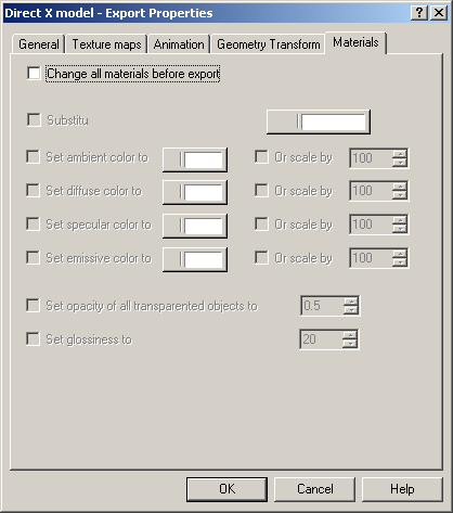
14 5.2 Polytrans/NuGraph Use the following settings when exporting using Polytrans, Nugraph or the respective MAX Plug-in: Make sure that your first dialog box matches this one exactly. These dialog boxes are the settings for the DirectX export from NuGraph. The settings shown in these screen shots are necessary for models to work correctly in TerraExporer. Figure 3-14-
15 5.3 Deep Exploration Exporting an X File Use the following settings when exporting an X file using Deep Exploration: In the Save As dialog box, in the Objects to save list, select All scene objects and Show Export Dialog. -15-

16 -16-
17 -17-
.")
18 Exporting an FLT file Use the following settings when exporting an FLT file using Deep Exploration: In the Save As dialog box, in the Objects to save list, select All scene objects and Show Export Dialog. 5.4 Google SketchUp Use the following settings when exporting a KML/KMZ using Google SketchUp: In the 3D Model Export, in the Export Type, select Google Earth (*.KMZ). Note: When using Google SketchUp 6, in the 3D Model Export, in the Export Type, select Google Earth 4 (*.KMZ). -18-

19 -19-
20 CHAPTER 6. STREAMING 3D MODELS USING POINT FEATURE LAYERS The best way to import many 3D models simultaneously is by streaming. Further optimization is achieved by using the XPL format. To stream a 3D model using a point feature layer: 1. Create a point Feature Layer where each point represents a model s pivot. The layer should contain the model s name as an attribute. 2. Import the point layer as a streaming layer. 3. Set an appropriate block width of the stream requests that are sent from TerraExplorer to the remote server. Note: It is not recommended to have TerraExplorer dynamically calculate the request block width according to performance related criteria in this situation. See: Determining an Appropriate Block Width in the TerraGate User Manual, for more information. 4. In the Layer Settings dialog box, click the Annotation tab. From the Symbol Type drop-down list, select 3D Model. 5. In the File Name, use the Field by Attribute dialog to set the model s path followed by the model name from the attribute value, e.g. c:\mymodels\[model_name]. 6. If using XPL models, set an appropriate LOD size. If possible, you should set the LOD for each model separately, using Field by Attribute. 7. Determine and select a reasonable Streaming Altitude and Max Visibility Distance. 8. For streaming the FLY file via the Internet, save it and build a TerraExplorer Viewer Kit for the Internet. See: Creating TerraExplorer Viewer Kits in the TerraExplorer Manual, for more information. -20-
21 CHAPTER 7. SUMMARY Displaying large-format models in a real-time environment can require extensive computer resources. This manual described the following methods of converting and creating resource-efficient and optimized models for real-time rendering in TerraExplorer: Model Geometry Model geometries should have no unnecessary vertices, faces or polygons. The model should be centered in the world coordinate system and the scale should represent true dimensions. See: Polygon Count and Other Considerations in the Model Building Guidelines chapter for further information. It is also recommended to group several small models into one model. Model Texture - Resource-efficient texture files are created by following the guidelines in the Texture Size section in the Model Building Guidelines chapter. It is also recommended to group several small textures into one texture. Model Format - Skyline s XPL models are the optimal format when streaming models via the Internet or locally importing large-format models (more than 20 Mb). See DirectX Specific in the Supported Formats chapter for more information. Streaming Streaming 3D models is the best way to import large-format models, locally and via the Internet. Selection of an appropriate block width is essential for efficient streaming. Usually, it is best to use the value 1222 m, and Max Streaming Altitude < Best LOD This value determines what texture resolution level TerraExplorer should use in relation to the viewer s distance from the model.setting this value in TerraExplorer (available when using XPL only) increases project efficiency. See: DirectX Specific in the Supported Formats chapter for more information. Remember! It is advised to run tests on the target hardware and optimize the models accordingly. Any reference to absolute numbers in this document is approximated for an average computer, and should be viewed as a rough guideline only. -21-
22 Copyright 2009 Skyline Software Systems Inc. All rights reserved. Skyline, SkylineGlobe, the Skyline logo, TerraExplorer, SkylineGlobe Pro, TerraDeveloper, TerraBuilder, TerraGate, and the SkylineGlobe Pro logo are trademarks of Skyline Software Systems Inc. All other trademarks are the property of their respective holders. Trademark names are used editorially, to the benefit of the trademark owner, with no intent to infringe on the trademark. Protected by U. S. Patents , , , , Other patents pending. Information contained in this document is subject to change without notice and does not represent a commitment on behalf of Skyline Software Systems Inc. No part of this document may be reproduced or transmitted in any form or by any means, electronic or mechanical, including photocopying without the written permission of Skyline Software Systems Inc. Skyline Software Systems, Inc Daly Drive, Suite 100 Chantilly, VA USA Main Tel: Main Fax: General Information: [email protected] Technical Support: [email protected] Web:
Version 6.6 Comparison Table
 Version 6.6 Comparison Table Information contained in this document is subject to change without notice and does not represent a commitment on behalf of Skyline Software Systems Inc. No part of this document
Publishing Hosted 3D Feature Layers. An Esri White Paper September 2015
 An Esri White Paper September 2015 Copyright 2015 Esri All rights reserved. Printed in the United States of America. The information contained in this document is the exclusive property of Esri. This work
User Guide Installing the 3D Studio plug-ins
 Prev Menu Next Back p. 1 Life Forms & 3D Studio Max User Guide Installing the 3D Studio plug-ins Plug-ins for importing and exporting 3DS files are automatically installed with Life Forms. However, if
Fireworks CS4 Tutorial Part 1: Intro
 Fireworks CS4 Tutorial Part 1: Intro This Adobe Fireworks CS4 Tutorial will help you familiarize yourself with this image editing software and help you create a layout for a website. Fireworks CS4 is the
Tantalis GATOR Expanded Image Help Guide
 Tantalis GATOR Expanded Image Help Guide Instructions for Increasing Image Resolution and Large size Printing The following are suggestions for printing an image using the Enabled MrSID plug-in and for
Instructions to view & create.kmz/.kml files from Google Earth
 Page 1 of 6 Instructions to view & create.kmz/.kml files from Google Earth Make sure you have Google Earth downloaded on your computer. If you don t, please visit this link to download Google Earth http://www.google.com/earth/download/ge.
Microsoft Picture Manager. Picture Manager
 Picture Manager Picture Manager allows you to easily edit and organize the pictures on your computer. Picture Manager is an application that was included with Microsoft Office suite for Windows 2003 and
AR-media TUTORIALS OCCLUDERS. (May, 2011)
") AR-media TUTORIALS OCCLUDERS (May, 2011) Copyright Copyright 2008/2011 Inglobe Technologies S.r.l. All rights reserved. No part of this publication may be reproduced, transmitted, transcribed, stored in
AR-media TUTORIALS OCCLUDERS (May, 2011) Copyright Copyright 2008/2011 Inglobe Technologies S.r.l. All rights reserved. No part of this publication may be reproduced, transmitted, transcribed, stored in
dopdf dopdf User Manual dopdf does PDF. For free. Copyright 2015 Softland
 does PDF. For free. User Manual User Manual for version 8 by Softland This documentation contains proprietary information of Softland. All rights reserved. No part of this documentation shall be reproduced,
Sweet Home 3D user's guide
 1 de 14 08/01/2013 13:08 Features Download Online Gallery Blog Documentation FAQ User's guide Video tutorial Developer's guides History Reviews Support 3D models Textures Translations Forum Report a bug
Workstation Applications for Windows. NVIDIA MAXtreme User s Guide
 Workstation Applications for Windows NVIDIA MAXtreme User s Guide Software Version: 6.00.xx NVIDIA Corporation February 2004 NVIDIA MAXtreme Published by NVIDIA Corporation 2701 San Tomas Expressway Santa
Scanning and OCR Basics
 Scanning and OCR Basics Scan Text Documents into Word 2003 using OCR Software 1. Place the document to scan face down on the flatbed scanner. 2. Launch Microsoft Word 2003 for Windows. 3. Select Acquire
DWGSee Professional User Guide
 DWGSee Professional User Guide DWGSee is comprehensive software for viewing, printing, marking and sharing DWG files. It is fast, powerful and easy-to-use for every expert and beginners. Starting DWGSee
Adobe Certified Expert Program
 Adobe Certified Expert Program Product Proficiency Exam Bulletin Adobe Photoshop CS4 Exam # 9A0-094 ACE Certification Checklist The checklist below will help guide you through the process of obtaining
Instructions for Creating a Poster for Arts and Humanities Research Day Using PowerPoint
 Instructions for Creating a Poster for Arts and Humanities Research Day Using PowerPoint While it is, of course, possible to create a Research Day poster using a graphics editing programme such as Adobe
Adobe Marketing Cloud Sharpening images in Scene7 Publishing System and on Image Server
 Adobe Marketing Cloud Sharpening images in Scene7 Publishing System and on Image Server Contents Contact and Legal Information...3 About image sharpening...4 Adding an image preset to save frequently used
Google Earth Connections for ArchiCAD 15. Product Manual
 Google Earth Connections for ArchiCAD 15 Product Manual GRAPHISOFT Visit the GRAPHISOFT website at http://www.graphisoft.com for local distributor and product availability information. Google Earth Connections
AXIS Video Capture Driver. AXIS Video Capture Driver. User s Manual
 AXIS Video Capture Driver User s Manual 1 Introduction The AXIS Video Capture Driver enables video stream input from one Axis network video product to be recorded and shown with third party products, e.g.
User Guide Win7Zilla
 User Guide Win7Zilla Table of contents Section 1: Installation... 3 1.1 System Requirements... 3 1.2 Software Installation... 3 1.3 Uninstalling Win7Zilla software... 3 Section 2: Navigation... 4 2.1 Main
INTRODUCTION to ESRI ARCGIS For Visualization, CPSC 178
 INTRODUCTION to ESRI ARCGIS For Visualization, CPSC 178 1) Navigate to the C:/temp folder 2) Make a directory using your initials. 3) Use your web browser to navigate to www.library.yale.edu/mapcoll/ and
3D Print Exporter Documentation 3D PRINT EXPORTER. Version 2.0 - Windows & Mac OSX
 3D PRINT EXPORTER Version 2.0 - Windows & Mac OSX 1 ABOUT 3D PRINT EXPORTER Step into the future of product development and manufacturing with the awesome power of ZBrush 4R2b and the new 3D Print Exporter.
Web-Based Enterprise Data Visualization a 3D Approach. Oleg Kachirski, Black and Veatch
 Web-Based Enterprise Data Visualization a 3D Approach Oleg Kachirski, Black and Veatch Contents - Introduction - Why 3D? - Applications of 3D - 3D Content Authoring - 3D/4D in GIS - Challenges of Presenting
Importing Terrain and Imagery into STK
 Importing Terrain and Imagery into STK CONTENTS OVERVIEW... 2 IMPORTING TERRAIN DATA TO A SCENARIO... 3 USING THE IMAGERY AND TERRAIN CONVERTER... 3 Creating a 3D Image Inlay... 3 Displaying Your Image
Creating a Guided Tour with Google Earth
 Creating a Guided Tour with Google Earth Before creating a tour, first orient yourself to basic Google Earth functions. To start, download Google Earth to your desktop. This is free through earth.google.com.
Intermediate Tutorials Modeling - Trees. 3d studio max. 3d studio max. Tree Modeling. 1.2206 2006 Matthew D'Onofrio Page 1 of 12
 3d studio max Tree Modeling Techniques and Principles 1.2206 2006 Matthew D'Onofrio Page 1 of 12 Modeling Trees Tree Modeling Techniques and Principles The era of sprites and cylinders-for-trunks has passed
Education Software Installer 2015
 Education Software Installer 2015 INSTALLATION GUIDE FOR WINDOWS OPERATING SYSTEMS Trademark notice SMART Notebook, SMART Ink, SMART Response, smarttech, the SMART logo and all SMART taglines are trademarks
MrSID Plug-in for 3D Analyst
 LizardTech MrSID Plug-in for 3D Analyst User Manual Copyrights Copyright 2009 2010 LizardTech. All rights reserved. Information in this document is subject to change without notice. The software described
TVI End User Guide. Version: Summer 2009 Release
 TVI End User Guide Version: Summer 2009 Release Table of Contents Control Center for Windows...2 TVI Control Center for Windows XP/Vista...2 Features...2 System Requirements...3 Installing Control Center...3
Fireworks 3 Animation and Rollovers
 Fireworks 3 Animation and Rollovers What is Fireworks Fireworks is Web graphics program designed by Macromedia. It enables users to create any sort of graphics as well as to import GIF, JPEG, PNG photos
NDSU Technology Learning & Media Center
 1 NDSU Technology Learning & Media Center QBB 150C 231-5130 www.ndsu.edu/its/tlmc Creating a Large Format Poster (Plot) Using PowerPoint 2013 Posters should be designed and created in a manner that best
Microsoft PowerPoint 2011
 Microsoft PowerPoint 2011 Starting PowerPoint... 2 Creating Slides in Your Presentation... 3 Beginning with the Title Slide... 3 Inserting a New Slide... 3 Adding an Image to a Slide... 4 Downloading Images
Customer Support Tool. User s Manual XE-A207 XE-A23S. Before reading this file, please read Instruction Manual of XE-A207 and XE-A23S.
 XE-A207 XE-A23S Customer Support Tool User s Manual Thank you for downloading this PDF file. Before reading this file, please read Instruction Manual of XE-A207 and XE-A23S. Save or print this file so
PREPARING PHOTOS for PRINTING
 PREPARING PHOTOS for PRINTING GENERAL WORKFLOW Open a PSD file SAVE AS a TIFF File Resize to Printer Resolution using IMAGE SIZE Sharpen with Layer Sharpen Add a Black Border using CANVAS SIZE Set the
Publishing KML Services Tutorial
 Publishing KML Services Tutorial Copyright 1995-2010 Esri All rights reserved. Table of Contents Tutorial: Publishing a KML service............................ 3 Copyright 1995-2010 ESRI, Inc. All rights
SkylineGlobe Web Package. Datasheet
 SkylineGlobe Web Package Version 6.5 w w w. S k y l i n e G l o b e. c o m Table of Contents Overview... 3 SkylineGlobe Web Package Main Components... 4 3D Web Application... 5 3D Application Advanced
AR-media Plugin v2.3. for Autodesk 3ds Max. QUICK START GUIDE (September, 2013)
") QUICK START GUIDE (September, 2013) Inglobe Technologies 2008/2013 Copyright Copyright 2008/2013 Inglobe Technologies S.r.l. All rights reserved. No part of this publication may be reproduced, transmitted,
QUICK START GUIDE (September, 2013) Inglobe Technologies 2008/2013 Copyright Copyright 2008/2013 Inglobe Technologies S.r.l. All rights reserved. No part of this publication may be reproduced, transmitted,
1. Definition of the project. 2. Initial version (simplified texture) 3. Second version (full textures) 5. Modelling and inserting 3D objects
 3. Second version (full textures) 5. Modelling and inserting 3D objects") Index 1. Definition of the project 2. Initial version (simplified texture) 3. Second version (full textures) 4. Final version in C++ 5. Modelling and inserting 3D objects 6. Interface design 7. Additional
Index 1. Definition of the project 2. Initial version (simplified texture) 3. Second version (full textures) 4. Final version in C++ 5. Modelling and inserting 3D objects 6. Interface design 7. Additional
ART 170: Web Design 1
 Banner Design Project Overview & Objectives Everyone will design a banner for a veterinary clinic. Objective Summary of the Project General objectives for the project in its entirety are: Design a banner
SkylineGlobe - Products Overview
 SkylineGlobe - Products Overview Skyline Software Systems, Inc. is a leading provider of 3D earth visualization software and services. The company offers a comprehensive platform of applications, tools
Introduction to Google Earth May 24, 2011. TJ Keiran Senior Planner / GIS Specialist Cowlitz-Wahkiakum Council of Governments
 Introduction to Google Earth May 24, 2011 TJ Keiran Senior Planner / GIS Specialist Cowlitz-Wahkiakum Council of Governments Purpose of this class Introduce free version of Google Earth Demonstrate common
Nero MediaStreaming for MCE Manual
 Nero MediaStreaming for MCE Manual Nero AG Copyright and Trademark Information This manual and all its contents are protected by copyright and are the property of Nero AG. All rights reserved. This manual
ACTIVE CONTENT MANAGER (ACM)
") ITServices SSC007-3333 University Way Kelowna, BC V1V 1V7 250.807.9000 www.ubc.ca/okanagan/itservices ACTIVE CONTENT MANAGER (ACM) Managing the Digital Asset Library March 8, 2007 digital assets.ppt 1
ITServices SSC007-3333 University Way Kelowna, BC V1V 1V7 250.807.9000 www.ubc.ca/okanagan/itservices ACTIVE CONTENT MANAGER (ACM) Managing the Digital Asset Library March 8, 2007 digital assets.ppt 1
Your CAD Programme. Virtually all 3D Rapid Prototyping machines and 3D Printers use the STL file format for input.
 Export STL Files From Your CAD Programme Introduction Virtually all 3D Rapid Prototyping machines and 3D Printers use the STL file format for input. Almost all CAD programs have a way to save or export
Files Used in this Tutorial
 Generate Point Clouds Tutorial This tutorial shows how to generate point clouds from IKONOS satellite stereo imagery. You will view the point clouds in the ENVI LiDAR Viewer. The estimated time to complete
VRayPattern also allows to curve geometry on any surface
 Introduction VrayPattern is a plug-in for 3dsmax and V-Ray VRayPattern allows to multiply geometry periodically without extra memory consumption. As a sample you can use any tiled geometry (or those with
Adding Animation With Cinema 4D XL
 Step-by-Step Adding Animation With Cinema 4D XL This Step-by-Step Card covers the basics of using the animation features of Cinema 4D XL. Note: Before you start this Step-by-Step Card, you need to have
Algolab Photo Vector
 Algolab Photo Vector Introduction: What Customers use Photo Vector for? Photo Vector (PV) is a handy tool for designers to create, cleanup, make fast corrections, edit designs with or without further conversion
Definiens XD 1.2.1. Release Notes
 Definiens XD 1.2.1 Release Notes Imprint and Version Document Version Copyright 2010 Definiens AG. All rights reserved. This document may be copied and printed only in accordance with the terms of the
Digital Photography. Digital Cameras and Digital Photography. Your camera. Topics Your Camera Exposure Shutter speed and f-stop Image Size Editing
 Digital Cameras and Digital Photography Topics Your Camera Exposure Shutter speed and f-stop Image Size Editing Faculty Innovating with Technology Program Aug 15, 2006 Digital Photography Your camera Virtually
Preparing Images for PowerPoint, the Web, and Publication
 What is Resolution?... 2 How Resolution Affects File Memory Size... 2 Physical Size vs. Memory Size... 3 Thinking Digitally... 4 What Resolution is Best For Printing?... 5 Professional Publications...
Done. Click Done to close the Capture Preview window.
 The Capture Preview window allows you to preview, edit, and customize a screen capture before it is saved to a file, inserted into your document, attached to an e-mail, or sent to a variety of other Output
Getting Started With LP360
 Getting Started With LP360 10/30/2014 1 Contents What is LP360?... 3 System Requirements... 3 Installing LP360... 4 How to Enable the LP360 Extension... 4 How to Display the LP360 Toolbar... 4 How to Import
NIS-Elements Viewer. User's Guide
 NIS-Elements Viewer User's Guide Publication date 10.09.2013 v. 4.20.00 Laboratory Imaging, s. r. o., Za Drahou 171/17, CZ - 102 00 Praha 10 No part of this publication may be reproduced or transmitted
Printing Guide. MapInfo Pro Version 15.0. Contents:
 MapInfo Pro Version 15.0 The purpose of this guide is to assist you in getting the best possible output from your MapInfo Pro software. We begin by covering the new print, import, and export features and
Self-Positioning Handheld 3D Scanner
 Self-Positioning Handheld 3D Scanner Method Sheet: How to scan in Color and prep for Post Processing ZScan: Version 3.0 Last modified: 03/13/2009 POWERED BY Background theory The ZScanner 700CX was built
CamGuard Security System CamGuard Security System Manual
 CamGuard Security System Manual JMC Electron Co.,LTD Brief Introduction... 3 Features... 3 System Requirements... 3 Configuration... 4 Add Camera... 4 Device Options... 4 About Alarm... 5 Alarm Actions...
Viewing and Troubleshooting Perfmon Logs
 CHAPTER 7 To view perfmon logs, you can download the logs or view them locally. This chapter contains information on the following topics: Viewing Perfmon Log Files, page 7-1 Working with Troubleshooting
ENHANCE. The Style Sheet Tool for Microsoft Dynamics NAV. Microsoft Dynamics NAV 5.0. User s Guide
 ENHANCE Microsoft Dynamics NAV 5.0 The Style Sheet Tool for Microsoft Dynamics NAV User s Guide The Style Sheet feature in Microsoft Dynamics TM NAV 5.0 has been enhanced with a new tool that allows you
CyberLink. PowerDVD Copy. User s Guide
 CyberLink PowerDVD Copy User s Guide Copyright and Disclaimer All rights reserved. No part of this publication may be reproduced, stored in a retrieval system, or transmitted in any form or by any means
TIBCO Spotfire Network Analytics 1.1. User s Manual
 TIBCO Spotfire Network Analytics 1.1 User s Manual Revision date: 26 January 2009 Important Information SOME TIBCO SOFTWARE EMBEDS OR BUNDLES OTHER TIBCO SOFTWARE. USE OF SUCH EMBEDDED OR BUNDLED TIBCO
TIBCO Spotfire Automation Services 6.5. User s Manual
 TIBCO Spotfire Automation Services 6.5 User s Manual Revision date: 17 April 2014 Important Information SOME TIBCO SOFTWARE EMBEDS OR BUNDLES OTHER TIBCO SOFTWARE. USE OF SUCH EMBEDDED OR BUNDLED TIBCO
SMS Database System Quick Start. [Version 1.0.3]
![SMS Database System Quick Start. [Version 1.0.3]](/thumbs/27/10030198.jpg "SMS Database System Quick Start. [Version 1.0.3]") SMS Database System Quick Start [Version 1.0.3] Warning ICP DAS Inc., LTD. assumes no liability for damages consequent to the use of this product. ICP DAS Inc., LTD. reserves the right to change this manual
SMS Database System Quick Start [Version 1.0.3] Warning ICP DAS Inc., LTD. assumes no liability for damages consequent to the use of this product. ICP DAS Inc., LTD. reserves the right to change this manual
Introduction to the TI Connect 4.0 software...1. Using TI DeviceExplorer...7. Compatibility with graphing calculators...9
 Contents Introduction to the TI Connect 4.0 software...1 The TI Connect window... 1 Software tools on the Home screen... 2 Opening and closing the TI Connect software... 4 Using Send To TI Device... 4
Embroidery Fonts Plus ( EFP ) Tutorial Guide Version 1.0505
 Tutorial Guide Version 1.0505") Embroidery Fonts Plus ( EFP ) Tutorial Guide Version 1.0505 1 Contents Chapter 1 System Requirements.................. 3 Chapter 2 Quick Start Installation.................. 4 System Requirements................
Embroidery Fonts Plus ( EFP ) Tutorial Guide Version 1.0505 1 Contents Chapter 1 System Requirements.................. 3 Chapter 2 Quick Start Installation.................. 4 System Requirements................
MULTIMEDIA INSTALLING THE MULTIMEDIA UPGRADE
 26 MULTIMEDIA With the PastPerfect MultiMedia Upgrade, you will be able to attach digital images and link multimedia files to your catalog records. This is an optional feature and may be purchased for
MediaRich for SharePoint User Guide
 MediaRich for SharePoint User Guide i 2003-2008 Automated Media Processing Solutions, Inc. dba Equilibrium. All Rights Reserved. U.S. Pat. No. 6,792,575 for automated media processing and delivery. Other
Glass coloured glass may pick up on scan. Top right of screen tabs: these tabs will relocate lost windows.
 Artec 3D scanner Instructions for Medium Handheld (MH) Scanner Scanning Conditions: Objects/surfaces that don t scan well: Black or shiny objects and objects with sharp edges or points, hair, glass, transparent
TABLE OF CONTENTS. INTRODUCTION... 5 Advance Concrete... 5 Where to find information?... 6 INSTALLATION... 7 STARTING ADVANCE CONCRETE...
 Starting Guide TABLE OF CONTENTS INTRODUCTION... 5 Advance Concrete... 5 Where to find information?... 6 INSTALLATION... 7 STARTING ADVANCE CONCRETE... 7 ADVANCE CONCRETE USER INTERFACE... 7 Other important
Microsoft Office PowerPoint 2013
 Microsoft Office PowerPoint 2013 Navigating the PowerPoint 2013 Environment The Ribbon: The ribbon is where you will access a majority of the commands you will use to create and develop your presentation.
NUI Galway Web Training Presentation
 NUI Galway Web Training Presentation Welcome Objective To provide training on how best to maintain and update University Web pages while also providing an introduction to systems & services provided by
Graphic Design. Background: The part of an artwork that appears to be farthest from the viewer, or in the distance of the scene.
 Graphic Design Active Layer- When you create multi layers for your images the active layer, or the only one that will be affected by your actions, is the one with a blue background in your layers palette.
What Resolution Should Your Images Be?
 What Resolution Should Your Images Be? The best way to determine the optimum resolution is to think about the final use of your images. For publication you ll need the highest resolution, for desktop printing
AdminToys Suite. Installation & Setup Guide
 AdminToys Suite Installation & Setup Guide Copyright 2008-2009 Lovelysoft. All Rights Reserved. Information in this document is subject to change without prior notice. Certain names of program products
Activity: Using ArcGIS Explorer
 Activity: Using ArcGIS Explorer Requirements You must have ArcGIS Explorer for this activity. Preparation: Download ArcGIS Explorer. The link below will bring you to the ESRI ArcGIS Explorer download page.
Copyright 2006 TechSmith Corporation. All Rights Reserved.
 TechSmith Corporation provides this manual as is, makes no representations or warranties with respect to its contents or use, and specifically disclaims any expressed or implied warranties or merchantability
SMART Ink 1.5. Windows operating systems. Scan the following QR code to view the SMART Ink Help on your smart phone or other mobile device.
 SMART Ink 1.5 Windows operating systems User s guide Scan the following QR code to view the SMART Ink Help on your smart phone or other mobile device. Trademark notice SMART Ink, SMART Notebook, SMART
Title 24 2013 Compliance Software: CBECC-Com
 Title 24 2013 Compliance Software: CBECC-Com California Building Energy Code Compliance for Commercial Buildings Creating Model Geometry using the Detailed Geometry Approach 1 Detailed Geometry Approach:
Contents. Launching FrontPage... 3. Working with the FrontPage Interface... 3 View Options... 4 The Folders List... 5 The Page View Frame...
 Using Microsoft Office 2003 Introduction to FrontPage Handout INFORMATION TECHNOLOGY SERVICES California State University, Los Angeles Version 1.0 Fall 2005 Contents Launching FrontPage... 3 Working with
PLAY VIDEO. Close- Closes the file you are working on and takes you back to MicroStation V8i Open File dialog.
 Chapter Five Menus PLAY VIDEO INTRODUCTION To be able to utilize the many different menus and tools MicroStation V8i offers throughout the program and this guide, you must first be able to locate and understand
MassArt Studio Foundation: Visual Language Digital Media Cookbook, Fall 2013
 INPUT OUTPUT 08 / IMAGE QUALITY & VIEWING In this section we will cover common image file formats you are likely to come across and examine image quality in terms of resolution and bit depth. We will cover
JustClust User Manual
 JustClust User Manual Contents 1. Installing JustClust 2. Running JustClust 3. Basic Usage of JustClust 3.1. Creating a Network 3.2. Clustering a Network 3.3. Applying a Layout 3.4. Saving and Loading
Feature Comparison of PTC Creo View MCAD. Product Suite. Topic Sheet. Page 1 of 6 Feature Comparison of PTC Creo View MCAD Product Suite
 Comparison of Product Suite User Interface Lite Microsoft Fluent paradigm Ribbon User Interface User interface customization Command finder Usage Standalone version Interoperability with PTC Products Performance
Windows Server Update Services 3.0 SP2 Step By Step Guide
 Windows Server Update Services 3.0 SP2 Step By Step Guide Microsoft Corporation Author: Anita Taylor Editor: Theresa Haynie Abstract This guide provides detailed instructions for installing Windows Server
Using the Olympus C4000 REV. 04/2006
 Using the Olympus C4000 REV. 04/2006 In the digital photographic world, information is captured and stored as data not as pictures. The input device (camera) converts light to a series of 1 s and 0 s and
TUTORIAL 4 Building a Navigation Bar with Fireworks
 TUTORIAL 4 Building a Navigation Bar with Fireworks This tutorial shows you how to build a Macromedia Fireworks MX 2004 navigation bar that you can use on multiple pages of your website. A navigation bar
Open icon. The Select Layer To Add dialog opens. Click here to display
 Mosaic Introduction This tour guide gives you the steps for mosaicking two or more image files to produce one image file. The mosaicking process works with rectified and/or calibrated images. Here, you
Copyright 2002-2003 Kinoma Inc. All rights reserved.
 Kinoma Producer 2 Version 2.0 Copyright 2002-2003 Kinoma Inc. All rights reserved. Before using this software, please read the End User License Agreement that is supplied together with this software. http://www.kinoma.com
Product Development. Using Critical Path EVM for the Microsoft Project Desktop Application Readme
 Product Development Using Critical Path EVM for the Microsoft Project Desktop Application Readme Published: June 2009 Table of Contents Introduction... 1 System Requirements... 1 Installing the Critical
SuperGIS Server 3.2 Standard Edition Specification
 SuperGIS Server 3.2 Standard Edition Specification 20140826 Specification 1. All of the services support SOAP (Simple Object Access Protocol). 2. Use map file created by SuperGIS Desktop as map services
Geberit ProPlanner 2014. Geberit ProPlanner 2014. Installation and Basic Functions Training Manual. Training Manual. Installation and Basic Functions
 Training Manual Installation and Basic Functions Legal Notice This manual and the software described in it form part of the license agreement and may be used or copied only in accordance with the license
MMGD0203 Multimedia Design MMGD0203 MULTIMEDIA DESIGN. Chapter 3 Graphics and Animations
 MMGD0203 MULTIMEDIA DESIGN Chapter 3 Graphics and Animations 1 Topics: Definition of Graphics Why use Graphics? Graphics Categories Graphics Qualities File Formats Types of Graphics Graphic File Size Introduction
How To Draw In Autocad
 DXF Import and Export for EASE 4.0 Page 1 of 9 DXF Import and Export for EASE 4.0 Bruce C. Olson, Dr. Waldemar Richert ADA Copyright 2002 Acoustic Design Ahnert EASE 4.0 allows both the import and export
IntegriSign Desktop User Manual
 IntegriSign Desktop User Manual C O N T E N T S Copyright... 1 Disclaimer... 1 Trademarks... 1 1. Welcome... 2 2. Where to find information... 2 2.1 IntegriSign Desktop Help... 2 3. Installing/Uninstalling
ESRI China (Hong Kong) Limited
 Limited") Tips for Creating 3D Graphics in ArcScene 9.x Article ID : 100003 Software : ArcGIS 3D Analyst 9.x Platform : Windows 2000, Windows XP Date : June 28, 2005 Background Prior to ArcGIS Desktop 9.0, we cannot
Tips for Creating 3D Graphics in ArcScene 9.x Article ID : 100003 Software : ArcGIS 3D Analyst 9.x Platform : Windows 2000, Windows XP Date : June 28, 2005 Background Prior to ArcGIS Desktop 9.0, we cannot
Layout Tutorial. Chapter 10: Getting Started
 Chapter 10: Layout Tutorial In this tutorial we will create a layout template, send a few views to a layout page, then save this document in PDF format. In this tutorial you will learn about: Creating
Making a Poster Using PowerPoint 2007
 Making a Poster Using PowerPoint 2007 1. Start PowerPoint: A Blank presentation appears as a Content Layout, a blank one one without anything not even a title. 2. Choose the size of your poster: Click
Deploying Microsoft RemoteFX on a Single Remote Desktop Virtualization Host Server Step-by-Step Guide
 Deploying Microsoft RemoteFX on a Single Remote Desktop Virtualization Host Server Step-by-Step Guide Microsoft Corporation Published: October 2010 Abstract This step-by-step guide walks you through the
Photo Album // Getting Started Guide. Getting Started Guide. Photo Album. Manage Your Media Online. AKJZNAzsqknsxxkjnsjx Getting Started Guide Page 1
 Getting Started Guide Photo Album Manage Your Media Online Getting Started Guide Page 1 Getting Started Guide: Photo Album Version 1.2 (11.08.11) Copyright 2011 GoDaddy.com, Inc. All rights reserved. Trademarks