Design Principle Connectivity and Permeability
|
|
|
- Belinda Weaver
- 9 years ago
- Views:
Transcription
1 Connectivity and Permeability Definition Connectivity (or permeability) refers to the directness of links and the density of connections in a transport network. A highly permeable network has many short links, numerous intersections, and minimal dead-ends. As connectivity increases, travel distances decrease and route options increase, allowing more direct travel between destinations, creating a more accessible and resilient transportation system (TDM Encyclopedia, 2009). Melbourne s laneways provide excellent permeability of the CBD Source: Booz & Co Overview Connectivity affects the degree to which transportation networks such as streets, walking and cycling paths, connect people to their destinations (including intermediate destinations such as public transport services). Good connectivity provides easy access to key destinations for pedestrians. Excellent connectivity actively seeks to discourage car use by making local trips easier and more pleasant by foot than by car. 1
.")
2 Transportation activity (walking or cycling) is positively associated with number of destinations and public transport and perceived access to bike lanes near home (Hoehner et al., 2005). In addition, the presence of well-maintained footpaths is associated with walking for recreation and for transport (Pikora et al., 2006). The type and density of intersections in the network (not just those for cars) has a significant impact on how people move around, whether by foot, bike, public transport or car (Gebel et al. 2005). A less permeable network has few intersections making it difficult to reach a destination in a reasonably direct route, and using a number of different routes between point A to point B (Frumkin et al., 2004). Destinations in areas with a well connected path network are easier to reach, than those in areas with a less connected path network. The diagram below shows a ten minute (800 metre) pedestrian catchment (often referred to as a ped-shed) in an area with a connected street network (left), compared with an area with a less connected street network (right). The diagram indicates the dramatic difference in catchment area between the two neighbourhood types. 800m radius walk in a compact neighbourhood 800m radius walk in a sprawling suburb Source: Walk Score Map courtesy of Lawrence Frank & Co. and the Sightline Institute. When combined with mixed use planning (see separate Fact Sheet), a permeable path network significantly increases the opportunities for residents to walk to undertake daily tasks, rather than drive. Studies have proven a link between network connectivity and use of active transport or car dependence (LUTRAQ, 1997; Kopelman et al, 2007). 2

3 The Land Use Transportation and Air Quality (LUTRAQ) study for Portland, Oregon showed that the odds of someone reporting that they walked for non-work purposes rose by 14 per cent for each quartile increase in the level of street connectivity where they live (King County ORTP 2005). Increased connectivity (combined with increased density, mixed use planning and good urban design) = increased walkability = better health Many people refer to 400 metres being a reasonable distance for people to walk. This stems from United States research in the 1960s. The purpose was to consider walking distances to public transport facilities. A reasonable walking distance is likely to be affected by location, topography, weather, pedestrian facilities, trip purpose and cultural factors. While a five minute walk (the time taken for the average person to walk 400 metres) may seem like a reasonable benchmark, it will not provide for a person s daily exercise needs alone. More recent studies have shown that people are willing to walk much greater distances if the walking environment is favourable (an average of 1.2 kilometres in good conditions). Active Traffic Street networks can make pedestrian movement easier than car movement. Source: Booz & Co 3

4 The Health & Planning Link A number of reviews have examined the relationship between neighbourhood walkability (including urban sprawl) and various measures of weight status (such as the Body Mass Index,). These show a positive relationship between living in urban sprawl and higher body weight (Robertson-Wilson et al., Papas et al. 2007, Black & Macinko 2008, Booth et al. 2005). Being overweight or obese is associated with living in areas with low population densities, curvilinear street networks, limited pedestrian access to commercial facilities and high dependence on cars to travel from place to place (Frumkin H, Frank L & Jackson R, 2004). How to achieve? Provide a grid path network - Spacing of pathways should optimise pedestrian movement and discourage car movement such as the use of cul-de-sac roads with pathways to enable pedestrian only access to the next street; Plan new subdivisions based on pedestrian and cyclist movement in the first instance before then fitting the road network into the plan; Retrofit existing subdivisions by closing road space (particularly one leg of cross intersections) while retaining cyclist/pedestrian paths (this makes pedestrian movement safer and more attractive while also improving vehicle safety at these intersections); Provide footpaths on both sides of all streets except where the road surface is so narrow that cars are expected to share the space with pedestrians. Provide local employment, recreation and retail facilities; Increase residential densities to support additional localised facilities (Over 30 dwellings per hectare will sustain a basic level of facilities within walking distance); Ensure pathway networks connect with arterial networks to travel longer distances (particularly relevant for cycle use); Australian Standard 1428 Parts 1 & 2, Part 13 AustRoads Guide to Traffic Engineering Practice: Pedestrians, sets a minimum standard footpath width of 1.2m as adequate for most road and street situations except in commercial and shopping environments, where pedestrian demands and accident risk may require wider paths. 4
. How to achieve?")
5 Space has been made to protect cyclists in Melbourne s network Source: Booz & Co Rule of Thumb On average people are willing to walk one kilometre to reach a functional destination. This is dependant on many factors including topography, weather and the walking environment including directness of the route. By providing path connections around every 100 metres a suburb will be highly permeable and more likely to encourage pedestrian trips. Where major barriers (such as creeks and railway lines) make connections expensive to provide, the network should confluence around fewer crossing points spaced around 500 metres apart. 5
 make connections expensive to provide, the network should confluence around fewer crossing points")
6 Encourage Highly interconnected path network providing choice of walking and cycling routes that lead to local and regional destinations Limited road space to encourage slower traffic speeds and higher pedestrian amenity; Limited road connectivity to encourage cars to use arterial roads rather than local streets and promote walking as the local trip mode; Closure of existing roads while maintaining pedestrian access to increase pedestrian and vehicular safety by removing unsafe intersections; Parking on street (rather than indented bays) to slow vehicle speeds; Improved pedestrian and cyclist safety through the provision of safe street crossings (See Safety and Surveillance and Active Transport Design Principles for further information). Require raised pavement crossings on all side streets in retail environments and any other location where pedestrian safety is an issue (such as left turn slip lanes); Install way-finding signage that utilises heads-up displays; Narrow road widths to increase pedestrian crossing opportunities and reduce vehicle speeds; and Construction of complete arterial and collector road networks early in the subdivision process to enable bus routes to commence in their optimal (long term) form. Avoid Gated communities as they restrict walking and cycling access and reduce the connectivity and connectivity within and outside the local street network Land uses, subdivision and design features that act as physical barriers and impede access to key destinations Cul-de-sacs except where pedestrian access is provided to link with other streets Delaying construction of walking and cycling paths in new subdivisions, as transport habits are difficult to change once established. Use of roundabouts (prohibit them in retail and high pedestrian volume environments). 6
.")
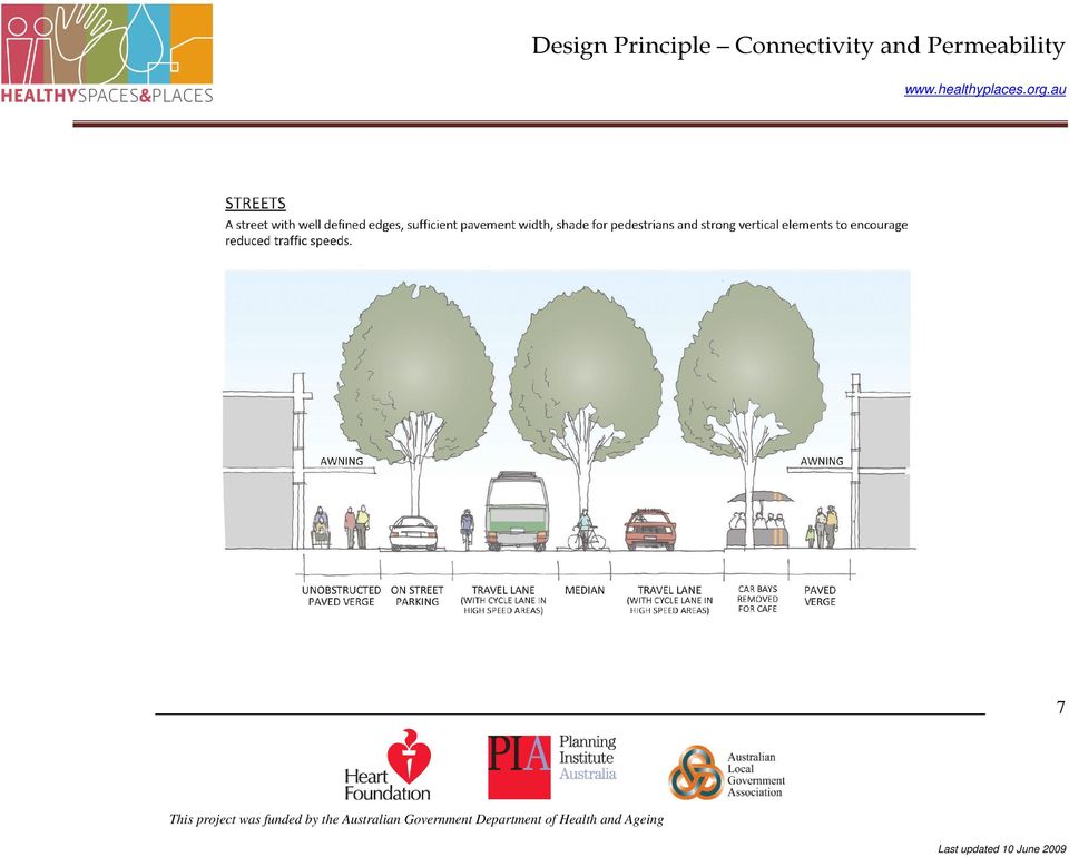
7 7
8 REFERENCES Australian Standard 1428 Parts 1 & 2, Part 13 AustRoads 1995, Guide to Traffic Engineering Practice: Pedestrians. Black JL & Macinko J. 2008, Neighborhoods and obesity, Nutrition Review, Vol.66(1), pp Booth KM, Pinkston MM, Poston WS. 2005, Obesity and the built environment, Journal of the American Dietetic Association Vol.105 (Issue 5 Suppl 1), pp Frumkin H, Frank L. and Jackson R. 2004, Urban Sprawl and Public Health: designing, planning and building for healthy communities, Island Press, Washington DC. Gebel K, King L, Bauman A, Vita P, Rigby A, and Capon A., 2005, Creating Healthy Environments: A Review of Links between the physical environment, physical activity and obesity, NSW Health Department and NSW Centre for Overweight and Obesity, Sydney. Kopelman P, Jebb SA, Butland B. 2007, Executive summary: Foresight 'Tackling Obesities: Future Choices' project. Obesity Review;8 Suppl 1:vi-ix. LUTRAQ (Land Use, Transportation, and Air Quality) study in Portland, Oregon Making the Land Use, Transportation, Air Quality Connection LUTRAQ Papas MA, Alberg AJ, Ewing R, Helzlsouer KJ, Gary TL, Klassen AC. 2007, The Built Environment and Obesity, Epidemiologic Reviews, Vol.29, pp Pikora TJ, Giles-Corti B, Knuiman MW, Bull FC, Jamrozik K, Donovan RJ. 2006, Neighborhood environmental factors correlated with walking near home: Using SPACES. Medical Science Sports Exercise Vol.38(4), pp Robertson-Wilson J, Giles-Corti B. Walkabilility, 2003, Neighbourhood Design, and Obesity. In: Townsend T, Alvanides S, Lake A, editors. Obesogenic environments: Complexities, perceptions and objective measures. UK: Wiley-Blackwell., in press. TDM (Transport Demand Management) Encyclopedia 2008, Roadway Connectivity, Victorian Transport Policy Institute Accessed 30 April This project is funded by the Australian Government Department of Health and Ageing

9 FURTHER READING Dill J, 2005, Measuring Network Connectivity for Bicycling and Walking, School of Urban Studies and Planning, Portland State University ( Ewing R, 1996, Best Development Practices; Doing the Right Thing and Making Money at the Same Time, Planners Press Goldberg, D., McCann, B., Frank, L., Chapman, J. & Kavage, S., 2007, New Data for a New Era: A Summary of the SMARTRAQ Findings Linking Land Use, Transportation, Air Quality and Health in the Atlanta Region, SMARTRAQ Summary Report, University of British Columbia, Canada. Ewing, R, Schmid T, Killingsworth R, Zlot A, and Raudenbush S, 2003, Relationship Between Urban Sprawl and Physical Activity, Obesity, and Morbidity, Urban Ecology pp Handy S, Paterson R, Butler K. 2003, Planning for street connectivity: getting from here to there, American Planning Association, Chicago. Hoehner CM, Ramirez LKB, Elliott MB, Handy SL, Brownson RC. 2005, Perceived and objective environmental measures and physical activity among urban adults. American Journal of Preventive Medicine, Vol.28 (2), pp Pikora T, Giles-Corti B, Bull F, Jamrozik K, Donovan R. 2003, Developing a framework for assessment of the environmental determinants of walking and cycling, Social Science Medicine, Vol.56: Saelens B, Sallis J & Frank L, Environment correlates of walking and cycling: Findings from the transportation, urban design and planning literatures, Annals of Behavioural Medicine, Vol.25(2), pp Transportation Research Board, Does the built environment influence physical activity? Examining the evidence. Transportation Research Board, Washington, DC. Whitzman C, Institutional Barriers and Enablers to Children s Independent Mobility, Presentation to Planning Institute of Australia Congress 2008, University of Melbourne. 9 This project is funded by the Australian Government Department of Health and Ageing

PEDESTRIAN PLANNING AND DESIGN MARK BRUSSEL
 PEDESTRIAN PLANNING AND DESIGN MARK BRUSSEL CONTENT OF LECTURE a) Walking as a transport mode b) Walking in Sub Sahara Africa c) Policies for pedestrians d) Pedestrian characteristics e) Network planning
Design Principle Social Inclusion
 Social Inclusion Definition A socially inclusive society is defined as one where all people feel valued, their differences are respected, and their basic needs are met so they can live in dignity (Cappo,
Department of State Development, Infrastructure and Planning. State Planning Policy state interest guideline. State transport infrastructure
 Department of State Development, Infrastructure and Planning State Planning Policy state interest guideline State transport infrastructure July 2014 Great state. Great opportunity. Preface Using this state
Footpath Extension Policy
 16.6.9 Footpath Extension Policy 1.0 FOOTPATH EXTENSION POLICY - INTENTION The Footpath Extension Policy provides for the ranking of new footpaths in the Council s footpath construction programme. The
ROAD INJURIES &FATALITIES
 VOLUME TWO THE HEALTH IMPACTS OF URBAN SPRAWL ROAD INJURIES &FATALITIES AN INFORMATION SERIES FROM ONTARIO COLLEGE OF FAMILY PHYSICIANS www.ocfp.on.ca 1. Injury and death on our roads Many people move
and 7 Queensland Transport, Moving People Connecting Communities: A Passenger Transport Strategy for Queensland 2007 2017, 2006
 and 7 Key result area 1 Shaping the future Developing new products and services, planning and behavioural change 1. Change behaviour to encourage sustainable transport choices To develop an awareness of
Bicycle Safety Webinar December 1 st 2010
 Bicycle Safety Webinar December 1 st 2010 Kay Teschke Kay Teschke is Professor in the Schools of Population and Public Health and of Environmental Health at the University of British Columbia. She is principal
Comprehensive Plan Policies that support Infill and Mixed Use
 Comprehensive Plan Policies that support Infill and Mixed Use Introduction A comprehensive plan provides a broad vision for the future growth of a community. It is often formulated using community visioning
Trends and issues Lake Te Koutu walkway, Cambridge
 27 Trends and issues Lake Te Koutu walkway, Cambridge 3 Trends 3.1 Journey to work Over the past two to three decades there has been a significant increase in private vehicle ownership and usage and a
OVERVIEW PROJECT SUMMARY
 OVERVIEW Cesar Chavez showcases how to successfully redesign a primary arterial route into a neighborhood destination, improving modal share, water sensitive design, biodiversity and safety whilst maintaining
Development Type - Retirement Accommodation
 Retirement Accommodation Introduction Australia has an ageing population and by 2056 up to one quarter of Australia s population will be aged 65 or older. Australia's population, like that of most developed
Winner. PIA Awards for. Planning Excellence. Healthy by Design: a planners guide to environments for active living
 Winner PIA Awards for Planning Excellence Healthy by Design: a planners guide to environments for active living Winner of the Planning for Health and Wellbeing Award and the President s Award presented
SCHEDULE 16 TO THE SPECIAL USE ZONE. Shown on the planning scheme map as SUZ16. BALLARAT RAILWAY STATION PRECINCT. Purpose
 SCHEDULE 16 TO THE SPECIAL USE ZONE Shown on the planning scheme map as SUZ16. BALLARAT RAILWAY STATION PRECINCT Purpose To facilitate the revitalisation of the Ballarat Station Precinct in accordance
Cycle safety. Monograph 17. Cycle safety: a national perspective. Cycle helmets
 Monograph 17 Cycle safety ISSN: 1444-3503 ISBN: 1 877071 85 4 Cycle safety: a national perspective Cycling is an important form of transport and recreation for many Australians. It is accessible to a wide
Promoting public health through Smart Growth
 >> Promoting public Smart Growth Building healthier communities through transportation and land use policies and practices Lawrence Frank, Sarah Kavage + Todd Litman PREPARED FOR: interaction and mobility.
Cycling Promotion and Cycling Safety: Is there a conflict? C.Woolsgrove *
 Proceedings, International Cycling Safety Conference 2012 7-8 November 2012, Helmond, The Netherlands Cycling Promotion and Cycling Safety: Is there a conflict? C.Woolsgrove * * European Cyclists Federation
A Bicycle Accident Study Using GIS Mapping and Analysis
 A Bicycle Accident Study Using GIS Mapping and Analysis Petra Staats, Graduate Assistant, Transportation Policy Institute, Rutgers University, New Brunswick, NJ, USA [email protected] Summary Surveys
6. Social & Community Facilities
 6.1. Objectives The built environment, with appropriate housing, public spaces and community facilities provides a basic platform to ensure residents have the best opportunity to build their own community.
ENGINEERING SOLUTIONS FOR DESIGNING YOUR SAFE ROUTES
 How to Get Started ENGINEERING SOLUTIONS FOR DESIGNING YOUR SAFE ROUTES Design Elements Selecting appropriate design treatments for school neighborhoods creates environments that address the needs of all
Advantages and Disadvantages of One Way Streets October 30, 2007
 Advantages and Disadvantages of One Way Streets October 30, 2007 0 P age Background As the revitalization of the Central Waterfront area moves forward, one issue that might need closer analysis is the
What happens when walkers and cyclists share the space?
 What happens when walkers and cyclists share the space? Narelle Haworth and Amy Schramm Walk21, Sydney, 21-23 October 2014 CRICOS No. 00213J Outline Safe Systems principles Review literature Crash and
Submission from Living Streets Aotearoa Wellington City Public Transport Spine Study
 Submission from Living Streets Aotearoa Wellington City Public Transport Spine Study Contact person: Ellen Blake Email: [email protected] Phone: 021 1067139 Date: 30 September 2013 About
Christchurch Cycle Design Guidelines
 Christchurch Cycle Design Guidelines 2013 Acknowledgements We would like to thank the contributions from ViaStrada and other contributors including Glen Koorey, Spokes, NZTA, Canterbury Public Health,
1. REPORT CONTEXT Description of the development (include all of the following that are known at the time of the application):
:") Transportation Assessment and Management Study Guidelines for Consultants INTRODUCTION This document is intended to provide guidelines for transportation consultants who produce Transportation reports
Transportation Assessment and Management Study Guidelines for Consultants INTRODUCTION This document is intended to provide guidelines for transportation consultants who produce Transportation reports
GOALS, OBJECTIVES, AND EVALUATION MEASURES
 GOALS, OBJECTIVES, AND EVALUATION MEASURES The Tallahassee-Leon County MPO is developing its first Bicycle and Pedestrian Master Plan, a 20- year plan that provides guidance for the development of facilities
 Walkable Communities Florida Department of Transportation State Safety Office Pedestrian and Bicycle Program April 1995 www.dot.state.fl.us/safety Twelve Steps for an Effective Program Page 1 Twelve Steps
Safety Evidence for Bicycling
 Photo: Boegh (Flickr) Cycling in Cities Research Program School of Population & Public Health The University of British Columbia Faculty of Health Sciences Simon Fraser University Driving near bicyclists
Topic 2 11/28/2012 Blocks & Street Network
 TOPIC 2 Blocks & Street Network Implementation Note: 1. Some recommendations are summarized in the tables herein. For complete recommendation language, please see the. 2. Recommendations referenced in
0.0 Curb Radii Guidelines Version 1.0.2
 Background In early 2014, Transportation Services initiated a review of the Division's design guidelines and standards to move our organization in a direction consistent with the transportation departments
Integrated Public Transport Service Planning Guidelines. Sydney Metropolitan Area
 Integrated Public Transport Service Planning Guidelines Sydney Metropolitan Area December 2013 CONTENTS 1. INTRODUCTION 3 1.1 Purpose 3 1.2 Background 3 1.3 Travel in Sydney Metropolitan Area 5 1.4 Objectives
TRANSPORTATION SERVICE STANDARDS ELEMENT GOALS, OBJECTIVES & POLICIES
 TRANSPORTATION SERVICE STANDARDS ELEMENT GOALS, OBJECTIVES & POLICIES Background One of the most critical public services provided by a community is the community s transportation system. An effective
Rural Road Safety Policy in Korea: Lesson Learned
 Regional Seminar on Safe, Climate Adaptive and Disaster Resilient Transport for Sustainable Development Nov. 17 th, Seoul Rural Road Safety Policy in Korea: Lesson Learned Sangjin HAN Korea Transport Institute
Capturing Value Uplift Benefiting from the Private Sector
 Capturing Value Uplift Benefiting from the Private Sector April 2013 Contents Understanding the wealth effect of Infrastructure Current Initiatives Transit Oriented Development The Challenge: Move away
Data Collection and Sampling issues -Preparing Low Carbon Mobility Plan
 Department of Civil Engineering/TRIPP Indian Institute of Technology Delhi http://tripp.iitd.ac.in Data Collection and Sampling issues -Preparing Low Carbon Mobility Plan K. Ramachandra Rao, G. Tiwari,
Planning and Design for Sustainable Urban Mobility
 1 Planning and Design for Sustainable Urban Mobility 2 1 UrbanizationUrbanization Rapid pace, largely uncontrolled growth, taking place mainly in developing countries 3 Global Urbanization Trends World
Walking strategy for older citizens knowledge base for planning in Kristiansand
 Summary: Walking strategy for older citizens knowledge base for planning in Kristiansand TØI report 1265/2013 Authors: Randi Hjorthol, Julie Runde Krogstad, Aud Tennøy Oslo 2013, 86 pages Increased motivation
Planning for Safe Transport Infrastructure at Schools
 Planning for Safe Transport Infrastructure at Schools Technical guidance for the provision of effective and safe transport infrastructure at schools April 2011 DRAFT NOT GOVERNMENT POLICY Planning for
The Road to Health Care Parity: Transportation Policy and Access to Health Care
 The Road to Health Care Parity: Transportation Policy and Access to Health Care April 2011 The Leadership Conference Education Fund 202.466.3434 voice 202.466.3435 fax www.civilrights.org I. Transportation
Rapid Transit Backgrounder
 Rapid Transit Backgrounder Moving Forward On Rapid Transit The concept of a Rapid Transit System for Winnipeg has been debated for over 30 years. City Council and the Province of Manitoba have demonstrated
Speed Limit Policy Isle of Wight Council
 APPENDIX C - 59 Speed Limit Policy Isle of Wight Council June 2009 Contents Section 1 Introduction 1.1 Links with the Local Transport Plan Section 2 Speed Limits on Urban Roads and Residential Areas 2.1
References. Associates, Vandewalle &. Stateline Area Bike and Pedestrian System Plan: SLATS, 2004.
 References Alaimo, Katherine, et al. Design Guidelines for Active Michigan Communities: Imagining, Creating, and Improving Communities for Physical Activity, Active Living, and Recreation. Flint, MI: Print
Delineation. Section 4 Longitudinal markings
 Delineation Section 4 Longitudinal markings The delineation guidelines have been developed to assist in designing and maintaining a quality delineation system. The guidelines are to comprise 19 sections
Shoppers and how they travel
 Shoppers and how they travel INFORMATION SHEET LN2 Over ten years ago, retailers in the Austrian city of Graz were asked how they thought their customers travelled to the shop, and shoppers were then interviewed
School Transportation Management
 Case Studies in Sustainable Transportation ISSUE PAPER 49 School Transportation Management Overview School transportation management (STM) is a catchall term for strategies that encourage students, parents
Transport demands in suburbanized locations
 Agronomy Research 12(2), 351 358, 2014 Transport demands in suburbanized locations M. Lukeš *, M. Kotek and M. Růžička Faculty of Engineering, Czech University of Life Sciences Prague, 165 21 Prague 6
VISION, DESIGN PRINCIPLES & OVERALL PLANNING STRATEGY
 3 VISION, DESIGN PRINCIPLES & OVERALL PLANNING STRATEGY The overall planning strategy for the Bank Street CDP is to ensure that future development is undertaken in a coordinated and planned approach, supported
Cycle Strategy 2006 2011
 Cycle Strategy 2006 2011 TABLE OF CONTENTS 1 INTRODUCTION... 1 2 POLICY BACKGROUND... 2 3 BACKGROUND... 6 4 MAIN OBJECTIVES... 8 5 TARGETS... 9 6 THE CYCLE NETWORK... 10 7 CONCLUSION... 13 Appendix A:
DEPARTMENT OF TRANSPORT CYCLING STRATEGY 29 February 2008
 DEPARTMENT OF TRANSPORT CYCLING STRATEGY 29 February 2008 INTRODUCTION The Department of Transport s Business Plan for the 2007/08 financial year stated the following: Government Aim: Quality Environment
Downtown Tampa Transportation Vision
 Downtown Tampa Transportation Vision Executive Summary August 1, 2006 Hillsborough County Metropolitan Planning Organization County Center, 18 th Floor Tampa, Florida 33602 813-272-5940 www.hillsboroughmpo.org
New Zealand all-age mandatory bicycle helmet law
 New Zealand all-age mandatory bicycle helmet law A public health and safety disaster New Zealand is one of only three countries in the world with national all-age mandatory bicycle helmet laws, the others
THE WANGANUI CYCLING STRATEGY
 THE WANGANUI CYCLING STRATEGY For Review by May 2008 1. INTRODUCTION Cycling is a practical, healthy and fun form of transport and recreation. The formation of the Wanganui Cycling Strategy is aimed at
Lawson Outline Plan External Traffic Analysis Working Paper
 Total Lawson Development ACTPLA 16 January 2009 Document No.: Prepared for ACTPLA Prepared by Maunsell Australia Pty Ltd Level 2, 60 Marcus Clarke Street, Canberra ACT 2600, Australia T +61 2 6201 3000
Performance Measures for a Sustainable Transportation Network Pasadena s Approach Frederick C. Dock, Ellen Greenberg, Mark Yamarone
 Performance Measures for a Sustainable Transportation Network Pasadena s Approach Frederick C. Dock, Ellen Greenberg, Mark Yamarone Abstract. As California cities move into the second decade of the 21st
WELCOME PROPOSALS FOR PENTAVIA RETAIL PARK WELCOME TO OUR EXHIBITION WHICH SETS OUT OUR PLANS TO DEVELOP THE PENTAVIA RETAIL PARK SITE.
 WELCOME WELCOME TO OUR EXHIBITION WHICH SETS OUT OUR PLANS TO DEVELOP THE PENTAVIA RETAIL PARK SITE. The purpose of the exhibition is to provide the community with the opportunity to view our initial ideas
This report card was produced by: 995 Market St, Suite 1450 San Francisco, CA 94702 www.walksf.org
 This report card was produced by: 995 Market St, Suite 1450 San Francisco, C 94702 www.walksf.org Special thanks to interns Christina Blackston and Haley Meisenholder for their contributions to this report
Pedestrian Safety in Strip Shopping Centres
 Pedestrian Safety in Strip Shopping Centres Author BE MTraffic MTransport MITE MIEAust CPEng Manager Transportation, Tasmania GHD Pty Ltd 2 Salamanca Square Hobart TAS 7000 [email protected] +61
FULFORD HEATH GOLF CLUB - Ride on Buggy Policy
 FULFORD HEATH GOLF CLUB - Ride on Buggy Policy 1. Introduction 1.1 Use is regulated by Fulford Heath Golf Club s policy with due regard to section 6 of The Equality Act 2010 1.2 During normal conditions
Active travel and health inequalities
 Active travel and health inequalities How walking and cycling can benefit the health of the most disadvantaged people INFORMATION SHEET FH12 Physical activity is essential for physical and mental well-being.
Alternatives to the Circ Project Prioritization Methodology Prepared for Circ Task Force July 28, 2011
 Alternatives to the Circ Project Prioritization Methodology Prepared for Circ Task Force July 28, 2011 CCRPC staff has developed a draft methodology described below and detailed in the attached pages for
Doing a little can accomplish a lot. Proposed Change of Municipal Class Environmental Assessment from Schedule from B to A+
 Doing a little can accomplish a lot. Proposed Change of Municipal Class Environmental Assessment from Schedule from B to A+ Erin Mills Parkway Intersections at Dundas Street and Burnhamthorpe Road Index
Walking or Cycling? Facts about Extent, Safety and Environmental Consequences
 Summary: TØI report 432/1999 Authors: Rune Elvik, Marika Kolbenstvedt, Ingunn Stangeby Oslo 1999, 54 pages Norwegian language Walking or Cycling? Facts about Extent, Safety and Environmental Consequences
Stonnington Cycling Strategy 2013-2018. December 2013 DRAFT
 Stonnington Cycling Strategy 2013-2018 December 2013 DRAFT Table of contents 1 Introduction... 1 2 Background... 4 2.1 Providers of cycling in Stonnington... 7 3 Key factors informing the Cycling Strategy...
High Mileage Moms - The Report
 High Mileage Moms - The Report Mothers are spending more time behind the wheel than ever before, and this is leaving less time for the rest of their lives, for everything from playing with children to
Getting there on foot, by cycle. A strategy to advance walking and cycling in New Zealand transport. February 2005 ISBN: 0 478 10004 3
 Getting there on foot, by cycle A strategy to advance walking and cycling in New Zealand transport February 2005 ISBN: 0 478 10004 3 FOREWORD In 2002, the Government released the New Zealand Transport
AREA: 0.16 acres NUMBER OF LOTS: 1 FT. NEW STREET: 0 LF
 FILE NO.: Z-9020 NAME: Hometown Tax Service Short-form PD-O LOCATION: Located at 3008 West 12 th Street DEVELOPER: Mark Green 65 Westfield Loop Little Rock, AR 72210 SURVEYOR: Kittler-Roberts Group, LLP
City of Auburn Americans with Disabilities Act (ADA) Transition Plan for Curb Ramps, Sidewalks, and Pedestrian Signals ADA TRANSITION PLAN
 Transition Plan for Curb Ramps, Sidewalks, and Pedestrian Signals ADA TRANSITION PLAN") Americans with Disabilities Act (ADA) Transition Plan for Curb Ramps, Sidewalks, and Pedestrian Signals ADA TRANSITION PLAN December 21, 2009 Public Works Department 171 N. Ross Street, Suite 200 Auburn,
Americans with Disabilities Act (ADA) Transition Plan for Curb Ramps, Sidewalks, and Pedestrian Signals ADA TRANSITION PLAN December 21, 2009 Public Works Department 171 N. Ross Street, Suite 200 Auburn,
Associati. The Annex Residents Association. The Annex Residents Association Cycling Policy Adopted by the Board, January 13, 2011.
 Associati The Annex Residents Association The Annex Residents Association Cycling Policy Adopted by the Board, January 13, 2011 The objective of these recommendations is to establish a set of guiding principles
Oregon City Clackamas County Red Soils Campus
 Oregon City Clackamas County Red Soils Campus Clackamas County Red Soils Campus Oregon City The Clackamas County Red Soils Campus focus area is located in the City of Oregon City. It is situated approximately
Why build the Silvertown Tunnel?
 Why build the Silvertown Tunnel? Over the last 30 years east London has changed with the redevelopment of former industrial areas into major commercial and residential districts. The development of Canary
Framework Traffic Management for Shared Zones in Large Private Estates AITPM 2014 National Conference
 Framework Traffic Management for Shared Zones in Large Private Estates AITPM 2014 National Conference Presented by : Wayne Johnson Senior Project Manager GTA Consultants [email protected] Outline
Needs Analysis. Long Beach Bicycle Master Plan. Bicycle Commuter Needs. LONG BEACH BICYCLE MASTER PLAN Needs Analysis
 Long Beach Bicycle Master Plan Needs Analysis The purpose of reviewing the needs of commuter and recreational bicyclists is twofold: (1) it is instrumental when planning a system which must serve both
OM-13: Transportation Management and Operations
 : Transportation and Operations 1-15 points Goal: Maximize the utility of the existing roadway network through use of technology and management of operations strategies. Sustainability Linkage Transportation
Car Club Strategy. London Borough of Richmond upon Thames
 Car Club Strategy London Borough of Richmond upon Thames December 2006 Page 1 of 16 Contents 1.0 Introduction 2.0 Policy Context 3.0 Sustainable Travel In Richmond 4.0 Car Clubs 5.0 Car Clubs in Richmond
Mayors Welcome Strong Surrey Votes Yes Coalition Support. Yes Vote Would Vastly Improve Transit and Transportation in Fast Growing City
 Mayors Welcome Strong Surrey Votes Yes Coalition Support Yes Vote Would Vastly Improve Transit and Transportation in Fast Growing City February 11, 2015 Vancouver, BC The Mayors Council on Regional Transportation
How to implement cycling solutions in a post-communist street system (and mentality) Marcin Hyła, VeloForum, 16 Oct.
 Marcin Hyła, VeloForum, 16 Oct.") How to implement cycling solutions in a post-communist street system (and mentality) Marcin Hyła, www.miastadlarowerow.pl VeloForum, 16 Oct. 2010 th What has communism to do with cycling? No free flow
How to implement cycling solutions in a post-communist street system (and mentality) Marcin Hyła, www.miastadlarowerow.pl VeloForum, 16 Oct. 2010 th What has communism to do with cycling? No free flow
Appendix E Transportation System and Demand Management Programs, and Emerging Technologies
 Appendix E Transportation System and Demand Management Programs, and Emerging Technologies Appendix Contents Transportation System Management Program Transportation Demand Management Program Regional Parking
A number of key guiding principals underline the approach to transportation within the plan area. These include:
 Transportation The principal form of transportation infrastructure will be vehicular roads augmented by a network of pedestrian and cycle routes. Transport infrastructure development will be commensurate
STATE TRANSIT BUS INFRASTRUCTURE GUIDE
 PROC 48.14 STATE TRANSIT BUS INFRASTRUCTURE GUIDE State Transit P.O Box 2557 Strawberry Hills NSW 2012 Facsimile (02) 9245 5710 www.sydneybuses.nsw.gov.au ISSUE 2 ` Table of Contents 1 INTRODUCTION...
Why active living? A HEALTH, ECONOMIC, ENvIRONMENTAL AND SOCIAL SOLuTION
 Why active living? A health, economic, environmental and social solution Introduction Being active is good for our health and our economy. It also has real benefits for our communities and for us as individuals.
Pedestrian Safety in car parks Designing for safety or just parking provision compliance?
 Pedestrian Safety in car parks Designing for safety or just parking provision compliance? A subsidiary of A division of www.luxmoore parking.com.au research consulting technology Terms of reference the
DEVELOPMENT BRIEF FOR LAND AT ALLOA ROAD, TULLIBODY
 DEVELOPMENT BRIEF FOR LAND AT ALLOA ROAD, TULLIBODY 1.0 Introduction and Purpose 1.1 Clackmannanshire Council is seeking to dispose of a site at Alloa Road, Tullibody for redevelopment. The site extends
Atlanta Regional Commission s Lifelong Communities Initiative: Creating Communities for All Ages and Abilities
 Atlanta Regional Commission s Lifelong Communities Initiative: Creating Communities for All Ages and Abilities Laura Keyes, MS, AICP and Cathie Berger, LMSW The Atlanta region is experiencing a monumental
Smart Growth Illustrated: Developer s Guidebook. City of Bentonville Community Development Department October 2006
 Smart Growth Illustrated: Developer s Guidebook City of Bentonville Community Development Department October 2006 1 Table of Contents What is Smart Growth...3 Six Goals of Smart Growth 5 Ten Tools of Smart
Trends in Australian children traveling to school 1971-2003: burning petrol or carbohydrates?
 1 Trends in Australian children traveling to school 1971-2003: burning petrol or carbohydrates? Hidde P. van der Ploeg 1, Dafna Merom 1, Grace Corpuz 2, Adrian E. Bauman 1 1 Centre for Physical Activity
Report Purpose To seek Council s approval of Municipal Policy SER-009-040: Traffic Calming
 Council Meeting Date: April 23, 2013 Agenda Item #: 13.1 MUNICIPAL POLICY (NEW) SER-009-040: TRAFFIC CALMING Report Purpose To seek Council s approval of Municipal Policy SER-009-040: Traffic Calming Recommendation
The State Government recognises. areas, and regulates bicycle
 cycling & THE LAW rules introduction for roads The State Government recognises The cycling South Australian as a legitimate Road Traffic form of Act including transport the Australian and an increasingly
THE IMPLICATIONS OF ALTERNATIVE GROWTH PATTERNS ON INFRASTRUCTURE COSTS
 City of Calgary THE IMPLICATIONS OF ALTERNATIVE GROWTH PATTERNS ON INFRASTRUCTURE COSTS REPORT APRIL 2, 2009 IBI GROUP REPORT City of Calgary EXECUTIVE SUMMARY Purpose of Report Calgary has seen record