A PENNSYLVANIA SCENIC RIVER
|
|
|
- Alaina Bruce
- 9 years ago
- Views:
Transcription
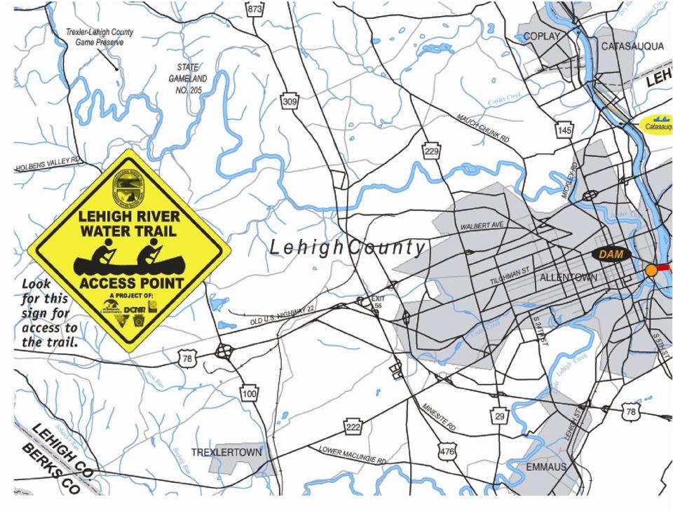
1 Lehigh River Water Trail Southern Section Map & Guide Water trails are recreational waterways on a lake, river, or ocean between specific points, containing access points and day-use and/or camping sites for the boating public. Water trails emphasize low-impact use and promote stewardship of the resources. Explore this unique Pennsylvania water trail. For your safety and enjoyment: Always wear a life jacket. Obtain proper instruction in boating skills. Know fishing and boating regulations. Be prepared for river hazards. Carry proper equipment. A PENNSYLVANIA SCENIC RIVER In 1982, a 32-mile section in the upper section Lehigh River corridor was designated a Pennsylvania Scenic River. This special designation is intended to help preserve the primitive qualities, as well as the natural and aesthetic values, of our rivers and adjacent land environment. Rivers so designated shall be free-flowing and capable of supporting both aquatic life, as well as water-based recreation. THE LEHIGH RIVER WATER TRAIL The Lehigh River Water Trail is 72-miles long, starting at White Haven and ending in the city of Easton at the Lehigh River s confluence with the Delaware River. There the traveler can continue down the Delaware towards Philadelphia and beyond to Delaware Bay. Northern Section This 41-mile segment of the Lehigh River Water Trail begins at White Haven at an access to the Lehigh Gorge State Park and ends at the Lehigh Gap at Blue Mountain at the Carbon-Lehigh-Northampton county line. Deep gorges and fast-moving water characterize this section of the Water Trail. Substantial canoeing or kayaking experience is required to maneuver most sections this reach of the river. It contains several access points and traverses 26 miles of the Lehigh Gorge State Park. Southern Section This 31-mile segment of the Water Trail begins at the Lehigh Gap at Blue Mountain at the Carbon-Lehigh-Northampton county line and ends at the confluence of the Lehigh River with the Delaware River in the city of Easton. This reach of the Water Trail widens out and tends to become more leisurely than the northern section. The land around the river is characterized by rolling hills and forested riparian corridors. The river contains numerous access points and passes through the urban centers of Allentown, Bethlehem, and Easton. RESPECT THE PRIVACY & RIGHTS OF LANDOWNERS Please respect the privacy and rights of landowners along the Juniata River Water Trail by obtaining permission before entering any privately owned land. Unless you are otherwise certain, assume the land is private property. In any case, avoid loud noises and boisterous behavior. Remember that sound carries across water much more clearly than on land. Some of the landowners enjoy the peace and solitude overlooking the river from their back yards. Use the same courtesy that you would want. A friendly wave or quiet greeting is always welcome. Help care for the land, water and cultural resources along the Juniata River by respecting wildlife, nature and other recreationists. It is important to wash footwear, boats, and vehicles to minimize the spread of invasive species from one place to another. Leave No Trace, a national outdoor ethics program, provides some guidelines to minimize your impact. For more information about Leave No Trace outdoor ethics, visit STEWARDSHIP THE LEHIGH RIVER Located in northeastern Pennsylvania, the Lehigh River originates in a series of glacial bogs and marshes in the area of Pocono Peak Lake in the Gouldsboro area about 15 miles southeast of Scranton. The elevation at the Lehigh River headwaters is approximately 2,200 feet above sea level, and drops nearly 1,000 feet during its 103-mile journey to its confluence with the Delaware River in Easton. The Lehigh s watershed is approximately 1,345 square-miles in area and consists of approximately 2,000 miles of streamways. It is a significant sub-basin within the Delaware River watershed. The Lehigh River forms the geopolitical boundary between many of the ten counties within its watershed. The river flows through Wayne, Lackawanna, Luzerne, Monroe, Carbon, Lehigh, and Northampton counties. The largest cities Allentown, Bethlehem, and Easton are found on the banks of the Lehigh in the river s lower reaches. There are many smaller historic hamlets and villages sprinkled from top to bottom. The river is impounded in several places by dams the most significant of which is the Francis E. Walter Dam in Luzerne and Carbon counties. At White Haven, the Lehigh River and its banks become part of Lehigh Gorge State Park. Over the next 32 miles, the river flows through a wilderness area and official Pennsylvania Scenic River section that is a mecca for whitewater boaters and mountain bikers. Near the town of Jim Thorpe and on into Bowmanstown, the river is characterized by calmer water and is widely enjoyed by kayakers, rafters, and canoeists. At the Carbon-Lehigh-Northampton county line, the river makes a dramatic cut through the Blue Mountain. Called Lehigh Gap, it separates the upper portion of the watershed from the two-county Lehigh Valley, as Lehigh and Northampton counties are called. The Lehigh River continues south past the historic towns of Walnutport, Slatington, Catasauqua, and Allentown where South Mountain deflects the Lehigh River s southward flow sharply to the east towards Bethlehem. At Bethlehem, the Lehigh River s speed continues to slow until it merges with the Delaware River after the dam in Easton. FISHING OPPORTUNITIES The Lehigh River supports a diverse fishery that includes trout, smallmouth bass, muskellunge, catfish, and American shad. The river is stocked with trout from White Haven to Jim Thorpe by the Pennsylvania Fish and Boat Commission and by several local sport-fishing groups from Jim Thorpe to Allentown. Check the current fishing regulations and seasons before fishing the river. Review this year s fishing summary online at: Leave no trace for camping and day use: 1. Plan and prepare. 2. Travel and camp on durable surfaces. 3. Dispose of waste properly. 4. Leave what you find. 5. Minimize campfires. 6. Respect wildlife. 7. Be considerate of other visitors.

2 Wear your life jacket. Some 80 percent of all recreational boating fatalities happen to people who are not wearing a life jacket. Expect to get wet. Even the best paddlers sometimes capsize or swamp their boats. Bring extra clothing in a waterproof bag. Be prepared to swim. If the water looks too hazardous to swim in, don t go paddling. If you capsize, hold on to your boat, unless it presents a lifethreatening situation. If floating in current, position yourself on the upstream side of the capsized boat. Scout ahead whenever possible. Know the river. Avoid surprises. Be prepared for the weather. Get a forecast before you go. Sudden winds and rain are common and can turn a pleasant trip into a risky, unpleasant venture. One wearable, Coast Guard-approved personal flotation device (PFD or life jacket) in serviceable condition and of the appropriate sizeis required for each person in your boat. If your boat is 16 feet or longer, one throwable device (seat cushion or ring buoy) is required. Canoes and kayaks, regardless of length, are not required to carry a throwable device. Life jackets must be worn by all children 12 years old and younger on all boats 20 feet or less in length while under way, and on all canoes and kayaks. Others are strongly encouraged to wear a PFD at all times on the water. All boats must display an anchor light (a white light visible 360 degrees) when at anchor between sunset and sunrise. Boats can use a lantern or clip-on battery-powered unit to meet this requirement. All powered boats must show running lights between sunset and sunrise. Between sunset and sunrise, unpowered boats must carry a white light (visible 360 degrees), installed or portable, ready to be displayed in time to avoid a collision. The size of the Lehigh River and the releases from the Francis E. Walter Dam make the river navigable in some way most days of the year. There are exceptions, however, particularly in the northern section of the Water Trail (above the Lehigh Gap), which should be monitored carefully in conditions of high flow. The northern section of the Water Trail where it passes through the Lehigh Gorge State Park contains Class II and III rapids requiring considerable expertise. It is not permitted for open canoes to float through this reach without special flotation devices installed in your boat. Nonetheless, some of the most exciting canoeing, rafting, and kayaking in the East is found here. The southern section is generally more subdued, but has some exciting rapids interspersed within its slower sections. This map will identify these areas for you. Remember, however, that due to intermittent water releases from the Francis E. Walter Dam, the water flow can be higher than recent rain activity would seem to indicate it should be. On the other hand, extreme drought conditions don t usually halt navigation; it only makes the boater s course more meandering. There is truly something for everyone here the expert looking for adventure and the novice paddling family looking for a gentle ride. Paddling when air temperatures are below 55 Fahrenheit is unsafe. PFDs should be worn by all occupants at all times. If someone else gets in trouble and you do not have your PFD on, you might both drown. Just wear it! PADDLING SAFETY TIPS PENNSYLVANIA BOATING REGULATIONS FLOATING THE RIVER Wear wading shoes or tennis shoes with wool, polypropylene, pile or neoprene socks. Never take your boat over a low-head dam. Portage (carry) your boat around any section of water about which you feel uncertain. Never boat alone. Boating safety increases with numbers. Keep painter lines (ropes tied to the bow) and any other roped coiled and secured. Never tie a rope to yourself or to another paddler, especially a child. Kneel to increase your stability before entering rougher water, like a rapid. If you collide with an obstruction, lean toward it. This will usually prevent your capsizing or flooding the boat. File a float plan with a reliable person, indicating where you are going and when you will return. Remember to contact the person when you have returned safely. All motorboats are required to carry a sound-producing mechanical device audible for a half-mile. Athletic whistles meet this requirement. All motorboats must be registered, regardless of where they launch. Unpowered boats (canoes, kayaks, rowboats, rafts) using Pennsylvania Fish & Boat Commission access areas must either be registered OR display a valid launch permit. Launch permits can be purchased on the web at Click the Outdoor Shop icon. Operating watercraft, including canoes, kayaks, and rafts, under the influence of alcohol or drugs is illegal. The law is strongly enforced for user safety. For further information on boating regulations, contact the Pennsylvania Fish & Boat Commission at There are several river outfitters and river guides in the Lehigh River valley, mostly in the northern section. Contact the regional tourist promotion agencies for a current list of outfitters. Many of these operators can also provide helpful information on current river conditions. All access points are indicated on the map, some of which are primitive, which means they are more suitable for canoes and other car-top boats. In addition, Wildlands Conservancy (a non-profit conservation organization) operates its Bike & Boat education/recreation program for groups of all sizes and ages. Contact them at or 610/ x36.

3 WILDLIFE ALONG THE RIVER One of the most significant raptor-migration routes in North America crosses the Lehigh River at Lehigh Gap. The physical aspects of Blue Mountain funnel every species of birds of prey (hawks, eagles) through the Lehigh River valley every year in the spring, but most abundantly in the autumn. Because the birds don t remain just on the ridge top as they move through, one can also see these impressive creatures in the valleys and riparian corridors. During the paddling season, one can see osprey, great blue heron, little green heron, merganser, wood duck, belted kingfisher, warbler of every stripe, and more. Black bear and rattlesnakes can be found in the upper reaches of the river; beaver, deer, fox, river otter, and muskrat can be found in many places along its entire length. EMERGENCY NUMBERS In most of the Lehigh River valley, dialing 911 will get you help.

4

5

6
7

Youghiogheny River From Confluence, Pa to Indian Creek Fayette and Somerset Counties
 Pennsylvania Fish & Boat Commission Biologist Report Youghiogheny River From Confluence, Pa to Indian Creek Fayette and Somerset Counties August 2012 Electrofishing Survey Originating in the mountains
THE NEW BOY SCOUT HANDBOOK AND THE SCOUT HANDBOOK HISTORY
 In this Issue: The New Boy Scout Handbook and the Scout Handbook History Staying Dry on Water Adventures Gone Fishing Vol. 1, No. 7 THE NEW BOY SCOUT HANDBOOK AND THE SCOUT HANDBOOK HISTORY The New 12th
Arkansas River Corridor Vision & Master Plan
 A r k a n s a s R I v e r C o r r I d o r P l a n Arkansas River Corridor Vision & Master Plan July 2005 Indian Nations Council of Governments A r k a n s a s R I v e r C o r r I d o r P l a n Partnership
Safety Afloat. Prerequisites!
 BSA Safety Afloat Developed by Rich Diesslin, BSA Lifeguard, [email protected], May, 2000 Copyright (c) 2000, Rich Diesslin, all rights reserved. This presentation may be reproduced and used locally by Scouting
AN INITIATIVE TO IMPROVE
 L OW E R C A R M E L R I V E R A N D L AG O O N F L O O D P L A I N R E S TO R AT I O N A N D E N H A N C E M E N T P R O J E C T AN INITIATIVE TO IMPROVE FLOOD PROTECTION RESTORE AND PROTECT RIPARIAN
AYAK GUIDE ISLAND STATE PARKS. NEW YORK STATE George E. Pataki, Governor
 AYAK & C KAYAK AYAK & CANOE GUIDE TO LONG ISLAND STATE PARKS NEW YORK STATE George E. Pataki, Governor NEW YORK STATE OFFICE OF PARKS, RECREATION AND HISTORIC PRESERVATION Bernadette Castro, Commissioner
Wetlands by Leslie Cargile
 Name: by Leslie Cargile What do the bogs in Ireland, the marshes in South Carolina, and the swamps of Louisiana have in common? If you said they re all wetlands, you d be right! are any land that is flooded
Level 1: Introduction to Kayaking (Sample Skills Course)
") Course Overview: The Introduction to Kayaking course is designed as a short program emphasizing safety, enjoyment and skill acquisition for entry level individuals in the public, private and commercial
Course Overview: The Introduction to Kayaking course is designed as a short program emphasizing safety, enjoyment and skill acquisition for entry level individuals in the public, private and commercial
Navigating the Credit River by Canoe, Kayak, Raft and Tubes
 Navigating the Credit River by Canoe, Kayak, Raft and Tubes NOTE: Credit Valley Conservation does not endorse navigation of the river, trespassing nor suggests that it is a safe recreational activity.
FISHING FOR FREEDOM 2015 June 5 th, 6 th and 7 th QUINCY, IL. TOURNAMENT RULES
 FISHING FOR FREEDOM 2015 June 5 th, 6 th and 7 th QUINCY, IL. TOURNAMENT RULES This primary mission of this tournament is to be a day of fun for both the boater and the Veteran. The competitive nature
1. Which city is the capital of New Zealand? a) Sydney; b) Wellington; c) Auckland.
 Sydney; b) Wellington; c) Auckland.") 1 Quick quiz Test your knowledge of New Zealand. 1. Which city is the capital of New Zealand? a) Sydney; b) Wellington; c) Auckland. 2. What are the native people of New Zealand called? a) Aborigine; b)
1 Quick quiz Test your knowledge of New Zealand. 1. Which city is the capital of New Zealand? a) Sydney; b) Wellington; c) Auckland. 2. What are the native people of New Zealand called? a) Aborigine; b)
TABLE OF CONTENTS. Page. Executive Summary
 TABLE OF CONTENTS Executive Summary Page i-ii Chapter 1: Purpose, Introduction and Background 1 Chapter 2: The Planning Process 4 Map 1: Naturally Reproducing Trout & Wilderness Trout Streams 13 Chapter
2015 BEAR HUNTING REGULATIONS
 2015 BEAR HUNTING REGULATIONS Please read the following regulations carefully. In addition, general hunting regulations, legal firearms, and bows and arrows allowed for big game hunting are described in
How To Plan A Buffer Zone
 Backyard Buffers Protecting Habitat and Water Quality What is a buffer? A buffer (also called a riparian buffer area or zone) is the strip of natural vegetation along the bank of a stream, lake or other
Friends of Allonby Canoe Club Liverpool Summary of Assessment of Risk
 Friends of Allonby Canoe Club Liverpool Summary of Assessment of Risk Assessor: Mike Moffitt Venue: South Dock Collingwood and surrounding docks Date: 04/11/13 Signed List hazards here. HAZARD WHO MIGHT
Highland Charter Township Recreation Plan. Oakland County Parks
 Highland Charter Township Recreation Plan Oakland County Parks Highland Oaks With 264 acres of parkland, Highland Oaks is located within the headwaters of the Shiawassee River and preserves sensitive habitat
Fishing, Hunting & Gathering The Rights and Responsibilities of First Nations People in Manitoba
 Fishing, Hunting & Gathering The Rights and Responsibilities of First Nations People in Manitoba First Nations people have always had a special relationship with the natural life forms that the land provides
The Nature Conservancy Offering Protected Lands for Sale in the Adirondacks Sustainable Forestry to Continue
 News release For immediate release August 21, 2008 Contact: Connie Prickett, (518) 576-2082 x162, [email protected] The Nature Conservancy Offering Protected Lands for Sale in the Adirondacks Sustainable
Floods are too much water on normally dry land. Rivers can flood after heavy rain has fallen over a long period of time. River flooding can last
 Floods are too much water on normally dry land. Rivers can flood after heavy rain has fallen over a long period of time. River flooding can last weeks or longer. River floods usually occur slowly enough
5-1. Section 5 ASC Treks
 5-1 Section 5 ASC Treks All treks that leave from Sabattis Scout Reservation must be pre-approved and all Pack and Paddle forms must be turned into the Hiawatha Seaway Council Service Center by April 1
4. Priority Areas of Conservation
 4. Priority Areas of Conservation A. SIGNIFICANT RESOURCE AREAS This Open Space and Farmland Plan identifies the key issues facing open space and agricultural resources in the Town, highlights the location
BSA Leave No Trace 101 Course Guide
 BSA Leave No Trace 101 Course Guide BSA Outdoor Ethics Task Force Revision Dates Original - February 21, 2010 Latest Revision November 6, 2015 Introductory Guidelines for Instructors BSA Leave No Trace
Responsibilities of the Coach - Summary
 Responsibilities of the Coach - Summary BCU Coaches have a number of responsibilities to ensure the paddlers in their care can enjoy the sport, are treated fairly and are protected from foreseeable harm.
Environmental Case Study Decatur, Georgia, DeKalb County A Suburban Creek Resists Channelization
 Introduction A visual examination of Doolittle Creek in a highly developed suburban county in Georgia yielded telltale signs of a creek whose original streambed had been altered. Examination of official
Safe Swim Defense Safety Afloat Review Instructor key correct answers are bold
 Safe Swim efense Safety float Review Instructor key correct answers are bold 1. The first and last point of both Safety float and Safe Swim efense are the same. Yes, Qualified Supervision is first, iscipline
Series 2016A-2 (Green Bonds) Final Proceeds Allocation April 2016
 Final Proceeds Allocation April 2016") Series 2016A-2 (Green Bonds) Final Proceeds Allocation April 2016 James L. McIntire Washington State Treasurer Summary The State of Washington offered green bonds to investors in September 2015, with approximately
Series 2016A-2 (Green Bonds) Final Proceeds Allocation April 2016 James L. McIntire Washington State Treasurer Summary The State of Washington offered green bonds to investors in September 2015, with approximately
HISTORIC PRESERVATION
 HISTORIC PRESERVATION Lehigh and Northampton counties have a wealth of historic buildings, structures, sites and districts that are found throughout the region. These resources add to the beauty and attractiveness
Map reading made easy
 Map reading made easy What is a map? A map is simply a plan of the ground on paper. The plan is usually drawn as the land would be seen from directly above. A map will normally have the following features:
Welcome to the Inland Wetlands Commission Town of Barkhamsted, CT
 Welcome to the Inland Wetlands Commission Town of Barkhamsted, CT Introduction Purpose Barkhamsted is a residential community located in Litchfield County, 15 miles northwest of Hartford. Our population
Benton MacKaye Trail - Section 2. Three Forks (FS 58) to GA. Highway 60. 11.4 miles
 to GA. Highway 60. 11.4 miles") General Benton MacKaye Trail - Section 2 Three Forks (FS 58) to GA. Highway 60 11.4 miles This is the longest and most remote section of the Benton MacKaye Trail (BMT) east of GA 5. It follows the Appalachian
General Benton MacKaye Trail - Section 2 Three Forks (FS 58) to GA. Highway 60 11.4 miles This is the longest and most remote section of the Benton MacKaye Trail (BMT) east of GA 5. It follows the Appalachian
personal watercraft p/u photo from last printing safe boating hints for fpo dbaw seal Gray Davis, Governor State of California
 fpo dbaw seal STATEOFCALIFORNIA AYS WDEPARTMENT OF BOATING AND WATER safe boating hints for personal watercraft p/u photo from last printing Gray Davis, Governor State of California Mary D. Nichols Secretary
Fun, famous, effective fitness and weight loss. With a camp near you.
 Fun, famous, effective fitness and weight loss. With a camp near you. California Florida Texas New York North Carolina Pennsylvania Hawaii Wisconsin Vancouver UK Family Camp 1) Wellspring Texas Set in
Lower Crooked Creek Watershed Conservation Plan EXECUTIVE SUMMARY
 EXECUTIVE SUMMARY Project Background Located in southwestern Pennsylvania, Crooked Creek is a major tributary of the Allegheny River, entering near Ford City in Armstrong County. It is rich in natural
CRITICAL JUDGMENT. Understanding and Preventing Canoe and Kayak Fatalities
 CRITICAL JUDGMENT Understanding and Preventing Canoe and Kayak Fatalities ACKNOWLEDGEMENTS Co-Authors Gordon Black, ACA Director of Safety Education & Instruction David E. Jenkins, ACA Director of Conservation
Summary of the Second College Grant Master Plan
 1 Summary of the Second College Grant Master Plan Dartmouth College owns and manages 27,000 acres of woodland in the Northern Forest region of New Hampshire, near Erroll, New Hampshire and the Maine state
Previous Stocking. Rainbow Trout Cutbow Trout. Brown Trout. Rainbow Trout. Rainbow Trout Snakeriver Cutthroat Trout Cutbow Trout.
 FISH SURVEY AND MANAGEMENT DATA (Salida) [email protected] / 719-530-5525 General Information: Turquoise Reservoir, a 1789 acre impoundment, offers good fishing for brown, rainbow, cutthroat and
An extraordinary launching point for nationally recognized programs
 Imagine preserving 40 acres of pristine water in the heart of Fairmount Park for future generations creating a sanctuary for learning about the wonders of nature in an urban setting challenging young people
Skaguay Reservoir. FISH SURVEY AND MANAGEMENT DATA Greg A. Policky - Aquatic Biologist (Salida) [email protected].
 greg.policky@state.co.") FISH SURVEY AND MANAGEMENT DATA (Salida) [email protected] / 719-530-5525 General Information: Skaguay Reservoir, a 114 acre impoundment, offers good fishing for rainbow and brown trout with an
FISH SURVEY AND MANAGEMENT DATA (Salida) [email protected] / 719-530-5525 General Information: Skaguay Reservoir, a 114 acre impoundment, offers good fishing for rainbow and brown trout with an
Gold Ray Dam Interagency Technical Team Meeting
 Gold Ray Dam Interagency Technical Team Meeting Agenda Public Outreach, Funding, Monitoring EA/BA/Permit Updates Deconstruction Plans Fish Passage & Salvage Plan Hydraulic Modeling Next Steps Public Outreach,
Think So You Don t Sink
 Think So You Don t Sink KEY TERMS Aquatic emergency: An emergency in the water in which a swimmer is either in distress or drowning. Aquatic environment: An environment in which recreational water activities
Background Information: The Mamquam River Floodplain Restoration Project
 Background Information: The Mamquam River Floodplain Restoration Project The Mamquam River Floodplain Restoration project is being undertaken in partnership with the Squamish River Watershed Society, Fisheries
BOATING SAFETY EDUCATION REQUIREMENT
 A vessel which is lawfully numbered in another state and which is brought into and kept in North Carolina may be used on the waters of this state during the 90 day period immediately ensuing its introduction
Land Specialties is North Georgia s premier development company for mountain lifestyle communities. Whether you imagine life on the lake, the links,
 Land Specialties is North Georgia s premier development company for mountain lifestyle communities. Whether you imagine life on the lake, the links, or the lofty peaks, we bring your vision into clear
Hazard / Risk Priority Action / Risk Control By whom
 PHOENIX OUTDOOR CENTRE RISK ASSESSMENT FORM GENERAL WATERSPORTS FOR SCHOOLS AND GROUPS Hazard / Risk Priority Action / Risk Control By whom Water Drowning Medium First Aid staff available at all times
Ecosystem Services in the Greater Houston Region. A case study analysis and recommendations for policy initiatives
 Ecosystem Services in the Greater Houston Region A case study analysis and recommendations for policy initiatives Ecosystem Services Ecosystems provide services through their natural processes that we
STATE OF MICHIGAN State-Specific Boating Safety Requirements
 STATE OF MICHIGAN State-Specific Boating Safety Requirements SL 1. Law Enforcement Authority The boating laws of Michigan are enforced by officers of the Law Enforcement Division of the Michigan Department
NOTE TO TEACHER: It is appropriate to introduce the mitochondria (where energy is made) as a major structure common to all cells.
 as a major structure common to all cells.") 5.2.1 Recall the cell as the smallest unit of life and identify its major structures (including cell membrane, cytoplasm, nucleus, and vacuole). Taxonomy level: 1.1 and 1.2-A Remember Factual Knowledge
5.2.1 Recall the cell as the smallest unit of life and identify its major structures (including cell membrane, cytoplasm, nucleus, and vacuole). Taxonomy level: 1.1 and 1.2-A Remember Factual Knowledge
Remaining Wetland Acreage 1,500,000 915,960 584,040-39%
 NEW JERSEY Original Wetland Acreage Remaining Wetland Acreage Acreage Lost % Lost 1,500,000 915,960 584,040-39% New Jersey Wetlands: Nearly 99 percent of New Jersey s wetlands are palustrine or estuarine.
Sabino Canyon History
 History During the Great Depression of the 1930 s, the CCC (Civilian Conservation Corporation) and the WPA (Works Progress Administration) built the nine bridges that crossed Sabino Creek. They originally
Learn. play. Explore. Camp fuller
 Learn. play. Explore. Camp fuller Dear Campers and Parents I am so glad that you are considering spending time with us at Camp Fuller. Our camp on Rhode Island s beautiful southern shore is a magical place
2012 Project Summary NORTHEAST RECREATIONAL BOATER SURVEY
 2012 Project Summary NORTHEAST RECREATIONAL BOATER SURVEY image courtesy of Urban Harbors Institute of UMass Boston A partnership among industry, government, and nongovernmental organizations conducted
Marchand Provincial Park. Draft Management Plan
 Marchand Provincial Park Draft Management Plan Marchand Provincial Park Draft Management Plan Table of Contents 1. Introduction... 3 2. Park History... 3 3. Park Attributes... 4 3.1 Natural... 4 3.2 Recreational...
NATURAL REGIONS OF KENTUCKY
 NATURAL WONDERS As you travel around Kentucky taking pictures, you are excited by what you see. Kentucky offers diverse and amazing sights. The Six Regions In the West, you see the Mississippi River, the
Activities and adventure for the whole family!
 Activities and adventure for the whole family! Activ Rådastrand, canoe trip through the unspoiled wilderness. We ll start at one of the beautiful lakes and paddle along a small, winding river which seeks
Project Theory-Climate Change and Traditional Ecological Knowledge Adaption in the Klamath Basin
 Project Theory-Climate Change and Traditional Ecological Knowledge Adaption in the Klamath Basin Frank K. Lake Lead Science and TEK Mentor for project Education 1995 B.S. University of California, Davis.
High Harbour at Lake Burton 685 Camp Harbour Lane Clayton, GA 30525 www.camphighharbour.com
 Lake Burton Retreat Center Group Rental Information YMCA CAMP HIGH HARBOUR High Harbour at Lake Burton 685 Camp Harbour Lane Clayton, GA 30525 www.camphighharbour.com Facilities YMCA Camp High Harbour
MOTORBOATING. STEM-Based
 MOTORBOATING STEM-Based BOY SCOUTS OF AMERICA MERIT BADGE SERIES MOTORBOATING Enhancing our youths competitive edge through merit badges Requirements 1. Do the following: a. Explain to your counselor the
Programmes within School Grounds 5. Land and Water Based Programmes 7. Duke of Edinburgh (D of E) Award Expeditions 10. Certificated Courses 11
 Award Expeditions 10. Certificated Courses 11") 2 2 About Us 4 Programmes within School Grounds 5 Land and Water Based Programmes 7 Duke of Edinburgh (D of E) Award Expeditions 10 Certificated Courses 11 Leadership Qualifications and 15 CPD Opportunities
2 2 About Us 4 Programmes within School Grounds 5 Land and Water Based Programmes 7 Duke of Edinburgh (D of E) Award Expeditions 10 Certificated Courses 11 Leadership Qualifications and 15 CPD Opportunities
LEAGUE NOTES ON APPROVED COMMUNITY WATER SUPPLY PLAN
 1 AUGUST 2011 LEAGUE NOTES ON APPROVED COMMUNITY WATER SUPPLY PLAN KEY ELEMENTS OF THE PLAN: 1. Replace the existing unsafe Ragged Mountain dam with a new dam and raise the reservoir pool level initially
Focus On You Photography TRT from Brockway Summit to Watson Lake
 Tahoe Rim Trail (TRT) From Hwy 267 (Brockway Summit) west to Watson Lake (Strong Intermediate Advanced) This trail is very demanding. It is almost 2100 ft. of climbing. The trail is up and down, up and
Fly Fishing Merit Badge Workbook
 Merit Badge Workbook This workbook can help you but you still need to read the merit badge pamphlet. The work space provided for each requirement should be used by the Scout to make notes for discussing
Welcome to the future of Terwillegar Park a Unique Natural Park
 Welcome to the future of Terwillegar Park a Unique Natural Park 1 Introduction The Terwillegar Park Concept Plan study will develop an overall concept plan, management objectives and development guidelines
BOATER S COPY INSTRUCTIONS FOR PROCTOR: AFTER BOATER COMPLETES TEST, SCORE TEST BY REMOVING
 INSTRUTIONS FOR PROTOR: FTER OTER OMPLETES TEST, SORE TEST Y REMOVING RIGHT HN STU FROM PRTS 2 & 3, IF T LEST 19 QUESTIONS RE ORRET, GIVE PRT 1 (PINK OPY) TO OTER S TEMPORRY ERTIFITE (REMOVE OTER SORE
boating/canoeing advancement opportunities scouting outcomes
 Boating/Canoeing Activities on the water have been popular in Scouting since the founding of our organization. In this program feature, your Scouts will have an opportunity to pursue several forms of aquatic
Trends in Active Outdoor Recreation Participation in United States:
 Trends in Active Outdoor Recreation Participation in United States: Findings from the 7th Edition Participation Study For the years 1998-2004 Sponsored by the Outdoor Industry Foundation www.outdoorindustry.org
Urban Stream Restoration Defining the Full Benefits of a Project. Warren C. High MACTEC Engineering and Consulting
 Urban Stream Restoration Defining the Full Benefits of a Project Warren C. High MACTEC Engineering and Consulting Economics in the Decision Process Return on Investment Willingness to Pay Municipal Growth
Region of Georgia : Mountains
 Region of Georgia : Mountains Northern most region of GA Cold weather in the winter Brasstown Bald is the highest point in Georgia Lots of creeks and streams High above sea level Poor soil for farming
Appendix A: Land Protection Plan
 Appendix A: Land Protection Plan In this appendix A.1 Introduction and Purpose A.2 Project Description A.3 Refuge Purposes A.4 Land Acquisition Policy for Urban Refuges A.5 Status of Resources to be Protected
BOATING AND SWIMMING RULES
 BOATING AND SWIMMING RULES Revised by the ALA Board of Directors October 25, 2014 A. GENERAL RULES: 1. All members participating in boating and swimming activities agree to know and follow these rules.
Howsham fish passage Consultation document
 Howsham fish passage Consultation document Report ENVIMNE000903 Final version 30 June 2016 We are the Environment Agency. We protect and improve the environment. Acting to reduce the impacts of a changing
King Edward VI School Southampton. Canoeing and Kayaking Generic Risk Assessment
 King Edward VI School Southampton Canoeing and Kayaking Generic Risk Assessment January 2012 Reviewed & updated by ECW Kayaking & Canoeing: Generic Risk Assessment Hazards arising from Outdoor Kayaking
Learn to Sail at MIT
 Learn to Sail at MIT Please read this before the next class and practice your knots: the bowline and the stunsail tack bend. Rigging Check with the dock staff to see if there are any restrictions. Grab
PORT CHESTER YACHT CLUB
 Lat 40 59 24 N NEWSLETTER - MARCH 2009 Long 73 39 33 W MEMBERS BREAKFAST SUNDAY MARCH 29TH 9:00 AM -12:00 PM On Sunday March 29th, the Port Chester Yacht club will be hosting a breakfast for all of our
SOMERSET COUNTY PARK COMMISSION
 SOMERSET COUNTY PARK COMMISSION Secondary Story Headline Manager of Environmental Education Center in Lord Stirling Park Page 2 Mission Statement The is committed to excellence in promoting stewardship
Canoe Skills. undefined. undefined [Close] PARTS OF A CANOE AND PADDLE ENTERING A CANOE PADDLING A CANOE BASIC CANOE STROKES HANDLING A CANOE
![Canoe Skills. undefined. undefined [Close] PARTS OF A CANOE AND PADDLE ENTERING A CANOE PADDLING A CANOE BASIC CANOE STROKES HANDLING A CANOE](/thumbs/40/21532537.jpg "Canoe Skills. undefined. undefined [Close] PARTS OF A CANOE AND PADDLE ENTERING A CANOE PADDLING A CANOE BASIC CANOE STROKES HANDLING A CANOE") undefined undefined More... undefined [Close] Canoe Skills PARTS OF A CANOE AND PADDLE ENTERING A CANOE PADDLING A CANOE BASIC CANOE STROKES HANDLING A CANOE PARTS OF A CANOE AND PADDLE file:///c /Documents%20and%20Settings/callin/My%2...cuments/`Courses/371/canoeing/528canoeskills.html
undefined undefined More... undefined [Close] Canoe Skills PARTS OF A CANOE AND PADDLE ENTERING A CANOE PADDLING A CANOE BASIC CANOE STROKES HANDLING A CANOE PARTS OF A CANOE AND PADDLE file:///c /Documents%20and%20Settings/callin/My%2...cuments/`Courses/371/canoeing/528canoeskills.html
WHAT MAPS SHOW US Maps do 4 things:
 WHAT MAPS SHOW US Maps show us a range of features, for example: Landforms: Settlement: Communication: Land Use: Geology: Other Info: - hills - valleys - mountains - isolated dwellings - farms - villages
APPENDIX B: TRAIL DEVELOPMENT AND MANAGEMENT STANDARDS
 APPENDIX B: TRAIL DEVELOPMENT AND MANAGEMENT STANDARDS This section provides guidance on a variety of trail issues for planners and developers of the Ice Age NST across the state. It also provides introductory
distance 100km (62m) Easy
 Easy") Experience Rating Easy distance 100km (62m) Cycling route: 100km (62 miles) Cycling in: The Great Waterway, Leeds Grenville Number of days cycling: 2 Recommended number of nights stay: 2 Experience rating:
Experience Rating Easy distance 100km (62m) Cycling route: 100km (62 miles) Cycling in: The Great Waterway, Leeds Grenville Number of days cycling: 2 Recommended number of nights stay: 2 Experience rating:
Flood Damage Prevention in Delaware County, NY
 Flood Damage Prevention in Delaware County, NY Susquehanna Basin 2 Villages, 8 Hamlets Schoharie Basin 1 Hamlet Cannonsville Basin 4 Villages, 6 Hamlets Pepacton Basin 2 Villages, 6 Hamlets Upper Delaware
Sensitive and Priority Areas
 Chapter 3 Sensitive and Priority Areas 3.1 Introduction U.S. EPA and IDEM policy require communities to place a priority on addressing combined sewer overflow (CSO) discharges to sensitive areas. The IDEM
The North State: Implementing the California Water Action Plan February 24, 2014
 The North State: Implementing the California Water Action Plan February 24, 2014 The North State Water Alliance applauds Governor Brown s California Water Action Plan (Action Plan) and his call for comprehensive
DELAWARE CANAL STATE PARK
 DELAWARE CANAL STATE PARK Realizing the Future: Post Decade of Flood Repairs June 2015 1 Table of Contents DCNR Mission, Vision and Goals.....3 Introduction to the Delaware Canal... 4 History.6 Re-Defining
CHAPTER I: INTRODUCTION. Background
 CHAPTER I: INTRODUCTION Background California State Law requires each county to adopt a General Plan for the physical development of the county and any land outside its boundaries which bears relation
Backyard Buffers that Work for People and Nature by Restoring Ecological Function
 Backyard Buffers that Work for People and Nature by Restoring Ecological Function What is a Wetland Buffer? A wetland buffer is a simple land management practice that is employed by municipalities to protect
Revising the Nantahala and Pisgah Land Management Plan Preliminary Need to Change the Existing Land Management Plan
 Revising the Nantahala and Pisgah Land Management Plan Preliminary Need to Change the Existing Land Management Plan Throughout the Plan 1. There is a fundamental need for the revised plan to address how
Boating Planning Guide
 Boating Planning Guide Key Terms Activity facilitator: Adventure camping: Adventure tripping: Boat: Boating activity: Near shore boating: Moving water: An individual of the provincial/territorial age of
Webelo to Boy Scout Transition
 Webelo to Boy Scout Transition Boy Scouts is a whole lot different than Cub Scouts or Webelos Scouts. The idea of graduating from a Cub Scout pack to a Boy Scout troop may be intimidating for some Webelos