Web Based Citizen Relationship Management (Civiq)
|
|
|
- Amberlynn Wilkinson
- 8 years ago
- Views:
Transcription
1 Web Based Citizen Relationship Management (Civiq) The Civiq CRM system has been implemented in the following Municipalities of West Bengal Naihati, Beharampur and Kanchrapara. Scope of Work: Designing entire workflow for all departments of municipal governance with GIS based tracking, analysis and reporting of all issues and thematic analysis for higher officials trying to offer better municipal service Background The need to create common platform to bring citizen into local governance through municipal operation to provide a range of services to improve the quality of life of the city was the basis for Civiq. Not every citizen have idea about whom to talk and where to register their problem.hence there is a need for a common platform to register their issues, which can be viewed by ward councillors and speed up the redressal process. With the constant effort of our government by de-centralizing the governance system up to the level of ward committee, citizens are mostly found in a criticizing role rather than a contributory role to the municipal governance. Thus came the idea of having a unique Location Intelligence basedcrmsystem which is a complete e-governance solution for Municipal bodies that allows citizens direct access to highest level of administration and the administration to provide effective and timely solution to issues faced by the citizens. Through its structured MIS format, it also enables detailed data analysis to facilitate long-term decision making. Input The inputs for this project are outlined below. Google map API Streets, important places not in Google map and associated latitude and longitude Municipality Ward No, Asseese No Problem Being Addressed The following problems were addressed in this project. Citizen s participation in Local Governance. Direct access of citizens to highest level of administration. Development of citizen s role as contributory from criticizing role. Increase transparency and accountability at local level. Getting report along with geographical location of concern in a seamless manner. A complete DSS (Decision Support System) solution backed by a comprehensive MIS structure. To help chairman to prioritize the action plan. Strengthening administrative responsiveness.

2 The Approach Taken The CRM package was developed on Visual Studio 2005 and.net 2.0 frameworks. The map was an integral part of the project so Google map was chosen as one map source. The execution of the project was done in four parts. 1.Generation of c# based code for server side activity as administrative log in, database updation, others 2. Generation of java script (using Google map js files) based GIS functionalities 3. Generation of stored procedures triggers in SQL Server Integration and deployment of all the above mentioned code in server environment.
 based GIS functionalities 3. Generation of stored procedures triggers in SQL Server 2005.")
3 Citizens Section: For this section following functionalities will be available: A map display area where the concerned municipal boundary will be displayed by default Basic GIS tools: Zoom In Zoom Out Polygon Pan Circle Concern Lodge Facility: Citizen can lodge their Concern by providing following information which is readily available under various drop downs: Concern Type Type of problem Location of Concern Street Comments (brief description of concern) Query Facilities: Citizens can generate query on various categories to view the status of any concern in any ward irrespective of their registration status (i.e. whether a registered citizen or not) 1. Ward No: The user can choose the ward 2. Date Range: The user will be allowed to choose the date range Type of Concern: A list of Concern (i.e. Sewerage, Drainage, Road etc.) would be available to generate query.
 1. Ward No: The user can choose the ward 2.")
4 Executive Corner interface with circle analysis: The Executive Corner further can be classified into three categories: Data Center Assistant/Sub-Assistant Engineer Executive Engineer Executive Engineer will be allowed to edit all lodged concerns. He will be the person who will close the complaint and add his comments. Also he can view the comments and status of all complaint from his service area based on ward and date

5 Political Corner:- The Political level platform is Political Corner where Chairman, CIC and Councilor will be allowed to view thematic and tabular representation of his service area complaints displaying the status of problems in different ward based on different service area and date. Chairman will be the person who will close the concern and add his comments.also he can view the comments and status of all Concerns from his chair based on ward and date.

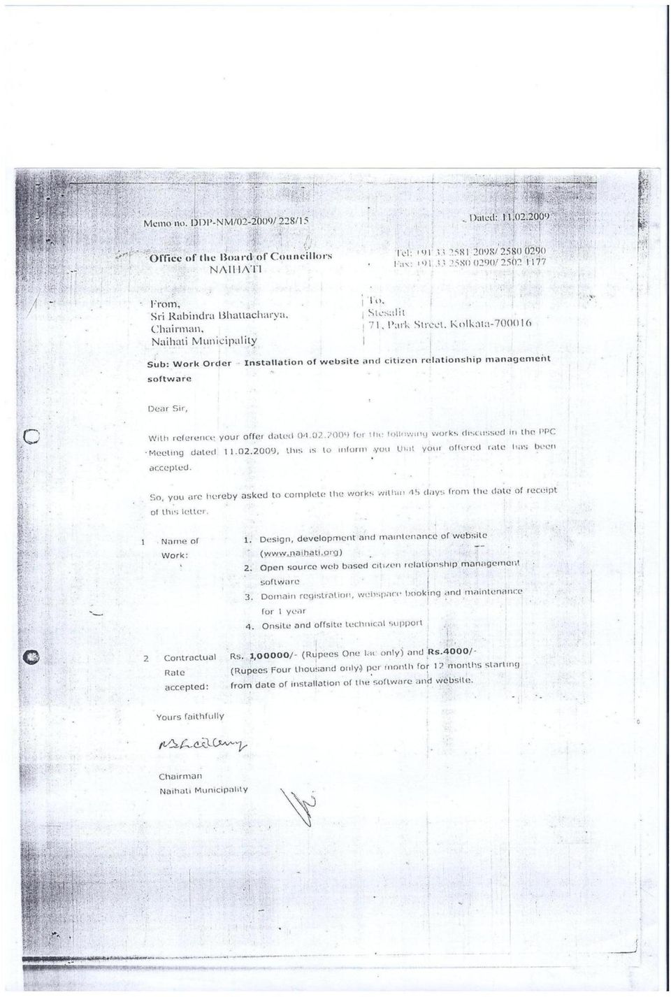
6 Municipality Period of Execution One-Time Implementation Charge Charges for Software Services Monthly Total Total Charge Months Charge Total Order Value Kanchrapara Naihati Beharampur Dec 08 to Nov 09 Mar 09 to Feb 10 Nov 08 to Oct TOTAL ORDER VALUE (Rs.)

7
8

9

10

Analysis One Code Desc. Transaction Amount. Fiscal Period
 Analysis One Code Desc Transaction Amount Fiscal Period 57.63 Oct-12 12.13 Oct-12-38.90 Oct-12-773.00 Oct-12-800.00 Oct-12-187.00 Oct-12-82.00 Oct-12-82.00 Oct-12-110.00 Oct-12-1115.25 Oct-12-71.00 Oct-12-41.00
 Patch Management Overview Report Date generated: 24 Jul 2014 09:41AM G Lighting Site: Stl Office Device: VAULT Missing Security Update for Windows Server 2003 (KB2982792) Windows Malicious Software Removal
CENTERPOINT ENERGY TEXARKANA SERVICE AREA GAS SUPPLY RATE (GSR) JULY 2015. Small Commercial Service (SCS-1) GSR
 JULY 2015. Small Commercial Service (SCS-1) GSR") JULY 2015 Area (RS-1) GSR GSR (LCS-1) Texarkana Incorporated July-15 $0.50690/Ccf $0.45450/Ccf $0.00000/Ccf $2.85090/MMBtu $17.52070/MMBtu Texarkana Unincorporated July-15 $0.56370/Ccf $0.26110/Ccf $1.66900/Ccf
JULY 2015 Area (RS-1) GSR GSR (LCS-1) Texarkana Incorporated July-15 $0.50690/Ccf $0.45450/Ccf $0.00000/Ccf $2.85090/MMBtu $17.52070/MMBtu Texarkana Unincorporated July-15 $0.56370/Ccf $0.26110/Ccf $1.66900/Ccf
Developing Business Intelligence and Data Visualization Applications with Web Maps
 Developing Business Intelligence and Data Visualization Applications with Web Maps Introduction Business Intelligence (BI) means different things to different organizations and users. BI often refers to
Basic Steps to Using the Wildlife Application
 Basic Steps to Using the Wildlife Application The intent of the Wildlife Application (http://gisweb1.serm.gov.sk.ca/wildlifelogin/form.asp) is to provide a tool to search an area in the province of Saskatchewan
Association of Public Data Users Annual Conference September 21, 2011
 Data Visualization in the NEW American FactFinder Association of Public Data Users Annual Conference September 21, 2011 After viewing this presentation, you will be able to: 1. Create a Reference Map 2.
ANDROID DEVELOPER RESUME USA
 Android Developer resume usa 1 of 5 1/12/2015 2:28 PM ANDROID DEVELOPER RESUME USA.NET Developers/Architects Resumes Please note that this is a not a Job Board - We are an I.T Staffing Company and we provide
Primavera Project Management System at WVDOT. Presented by Marshall Burgess, WVDOT Stephen Cole, Stephen Cole Consulting Jervetta Bruce, CDP, Inc.
 : Integrating GIS With Primavera Project Management System at WVDOT Presented by Marshall Burgess, WVDOT Stephen Cole, Stephen Cole Consulting Jervetta Bruce, CDP, Inc. WVDOT Geographic Information System
How to use PGS: Basic Services Provision Map App
 How to use PGS: Basic Services Provision Map App The PGS: Basic Services Provision Map App The main features of the PGP Basic Services web application includes: Navigation Tools Map Tools Main Map Links
NatureServe s Environmental Review Tool
 NatureServe s Environmental Review Tool A Repeatable Online Software Solution for Agencies For More Information, Contact: Lori Scott Rob Solomon lori_scott@natureserve.org rob_solomon@natureserve.org 703-908-1877
AT&T Global Network Client for Windows Product Support Matrix January 29, 2015
 AT&T Global Network Client for Windows Product Support Matrix January 29, 2015 Product Support Matrix Following is the Product Support Matrix for the AT&T Global Network Client. See the AT&T Global Network
Designing the GIS/Website Interface Millennium Earth Project: A Visual Framework for Sustainable Development (Virtual Global Earth Project)
") Designing the GIS/Website Interface Millennium Earth Project: A Visual Framework for Sustainable Development (Virtual Global Earth Project) Table of Contents Summary of the project... 3 Major Tasks...
Designing the GIS/Website Interface Millennium Earth Project: A Visual Framework for Sustainable Development (Virtual Global Earth Project) Table of Contents Summary of the project... 3 Major Tasks...
Course Title: Reporting in Microsoft Dynamics CRM 2011
 Course Code: SSM80445 Course Title: Reporting in Microsoft Dynamics CRM 2011 Duration: 1 Day About this Course This one-day instructor-led course, Reporting in Microsoft Dynamics CRM 2011, provides students
Release Notes Scribe Adapter for Microsoft Dynamics
 Scribe Adapter for Microsoft Dynamics CRM Requirements Version 4.0 Release Date January 28, 2008 Insight 6.2 or higher Microsoft Dynamics CRM 3.x, 4.x, or Microsoft Dynamics CRM Live Microsoft.NET Framework
SOUTH DELHI MUNICIPAL CORPORATION. Use of information technology in collection of Property Tax
 SOUTH DELHI MUNICIPAL CORPORATION Use of information technology in collection of Property Tax Presentation Overview Project Overview. Functional Overview. Over View : MCD Property Tax Web Portal. Statically
UK Location Programme
 Location Information Interoperability Board Data Publisher How To Guide Understand the background to establishing an INSPIRE View Service using GeoServer DOCUMENT CONTROL Change Summary Version Date Author/Editor
ONE CALL CENTER REPORT
 ITIC Mobile HTML Version of Excavators Ticket HTML format for proper display on any device Allows for different fonts, colors and embedded links Printed copies use greyscale TicketLINK Enhanced for ETM
ACTIVE MICROSOFT CERTIFICATIONS:
 Last Activity Recorded : August 30, 2012 Microsoft Certification ID : 30999 BERT VAN HOVE BARON EMPAINLAAN 68 MECHELEN, 2800 BE bert@road2result.be ACTIVE MICROSOFT CERTIFICATIONS: Microsoft Certified
ishare in the Cloud Service Definition v5.0
 Service Definition v5.0 An overview of ishare in the Cloud ishare is an end to end Enterprise GIS for public sector comprising a spatial data warehouse, rich functionality browser based GIS including editing
MS 10977B Upgrading Your SQL Server Skills to Microsoft SQL Server 2014
 MS 10977B Upgrading Your SQL Server Skills to Microsoft SQL Server 2014 Description: Days: 5 Prerequisites: This five-day instructor-led course teaches students how to use the enhancements and new features
An SEI CMMI Level 3 Company CASE STUDIES. www.stesalitsystems.com
 An SEI CMMI Level 3 Company CASE STUDIES Web GIS Application/Software Development Survey of India Assignment name: Development of Web-based Imagery Transaction Registry (ITR) Name of Client: Survey of
Reef Explorer User Guide
 Reef Explorer User Guide Contents USER INTERFACE...2 DATA CONTENT...3 BASEMAPS...4 ESRI BASEMAPS...4 National Geographic World Map...4 Light Gray Canvas Map...4 Ocean Basemap...4 World Terrain Base...4
RadBlue Load Tester Version 6. [Released: 09 DEC 2009]
![RadBlue Load Tester Version 6. [Released: 09 DEC 2009]](/thumbs/27/11028632.jpg "RadBlue Load Tester Version 6. [Released: 09 DEC 2009]") Version 6 [Released: 09 DEC 2009] In this release, we modified the database setup screen of the RLT installer to default to SQL server information (the recommended database). The Transcript has been modified
Version 6 [Released: 09 DEC 2009] In this release, we modified the database setup screen of the RLT installer to default to SQL server information (the recommended database). The Transcript has been modified
COMPARISON OF FIXED & VARIABLE RATES (25 YEARS) CHARTERED BANK ADMINISTERED INTEREST RATES - PRIME BUSINESS*
 CHARTERED BANK ADMINISTERED INTEREST RATES - PRIME BUSINESS*") COMPARISON OF FIXED & VARIABLE RATES (25 YEARS) 2 Fixed Rates Variable Rates FIXED RATES OF THE PAST 25 YEARS AVERAGE RESIDENTIAL MORTGAGE LENDING RATE - 5 YEAR* (Per cent) Year Jan Feb Mar Apr May Jun
COMPARISON OF FIXED & VARIABLE RATES (25 YEARS) 2 Fixed Rates Variable Rates FIXED RATES OF THE PAST 25 YEARS AVERAGE RESIDENTIAL MORTGAGE LENDING RATE - 5 YEAR* (Per cent) Year Jan Feb Mar Apr May Jun
Strategic Information Management System for National AIDS Control Organisation, Ministry of Health and Family Welfare, Government of India
 Strategic Information Management System for National AIDS Control Organisation, Ministry of Health and Family Welfare, Government of India CLIENT: National AIDS Control Organisation, Ministry of Health
ArcGIS. Server. A Complete and Integrated Server GIS
 ArcGIS Server A Complete and Integrated Server GIS ArcGIS Server A Complete and Integrated Server GIS ArcGIS Server enables you to distribute maps, models, and tools to others within your organization
Guide by. A Guide to the Talkdesk and MAGENTO. Integration. Advantages / How to use / Activate and setup the integration / more...
 Guide by A Guide to the Talkdesk and MAGENTO Integration Advantages / How to use / Activate and setup the integration / more... // A Guide to the Talkdesk and Magento Integration integration // table of
Updating Your SQL Server Skills to Microsoft SQL Server 2014 (10977) H8B96S
 H8B96S") HP Education Services course data sheet Updating Your SQL Server Skills to Microsoft SQL Server 2014 (10977) H8B96S Course Overview In this course, you will learn how to use SQL Server 2014 product features
HP Education Services course data sheet Updating Your SQL Server Skills to Microsoft SQL Server 2014 (10977) H8B96S Course Overview In this course, you will learn how to use SQL Server 2014 product features
City & County of San Francisco Permit & Project Tracking System
 City & County of San Francisco Permit & Project Tracking System PPTS Sneak Preview March 20, 2013 Welcome & Opening Statements AGENDA 1. Opening Statements Department Directors 2. Project Background 3.
Upgrading Your SQL Server Skills to Microsoft SQL Server 2014 va
 Upgrading Your SQL Server Skills to Microsoft SQL Server 2014 va Day(s): 5 Course Code: M10977 Version: A Overview This five-day instructor-led course teaches students how to use the enhancements and new
Service Management Simplified
 Service Management Simplified TOPdesk develops, markets, implements and supports software which helps organisations to efficiently manage the services they provide. Our vision is to create a user-friendly
Please contact Cyber and Technology Training at (410)777-1333/technologytraining@aacc.edu for registration and pricing information.
777-1333/technologytraining@aacc.edu for registration and pricing information.") Course Name Start Date End Date Start Time End Time Active Directory Services with Windows Server 8/31/2015 9/4/2015 9:00 AM 5:00 PM Active Directory Services with Windows Server 9/28/2015 10/2/2015 9:00
Course Name Start Date End Date Start Time End Time Active Directory Services with Windows Server 8/31/2015 9/4/2015 9:00 AM 5:00 PM Active Directory Services with Windows Server 9/28/2015 10/2/2015 9:00
Course 10977A: Updating Your SQL Server Skills to Microsoft SQL Server 2014
 www.etidaho.com (208) 327-0768 Course 10977A: Updating Your SQL Server Skills to Microsoft SQL Server 2014 5 Days About this Course This five day instructor led course teaches students how to use the enhancements
CABINET 9 th February 2006. Report of the Director of Partnerships and Customer Services
 CABINET 9 th February 2006 Report of the Director of Partnerships and Customer Services ITEM 11 CRM DEVELOPMENT Purpose of the Report To seek approval to the replacement for the Council s Customer Relationship
By: KPIT Technologies Limited. NHAI Portal Guide
 Design, Development, Deployment, Operation and Maintenance of Vehicle Tracking System (VTS) using Global Positioning System (GPS) devices for National Highway Authority of India By: KPIT Technologies Limited
JOB TITLE: CURRENT CLASSIFICATION/GRID POSITION # IT Tech III AD Grid Level 5(e) #121 Database Administrator
 #121 Database Administrator") COUNTY OF GRANDE PRAIRIE JOB DESCRIPTION JOB TITLE: CURRENT CLASSIFICATION/GRID POSITION # IT Tech III AD Grid Level 5(e) #121 Database Administrator NOC CODE: 2172 STANDARD HOURS: 35 hours/week (non-management)
COUNTY OF GRANDE PRAIRIE JOB DESCRIPTION JOB TITLE: CURRENT CLASSIFICATION/GRID POSITION # IT Tech III AD Grid Level 5(e) #121 Database Administrator NOC CODE: 2172 STANDARD HOURS: 35 hours/week (non-management)
Computer Information Systems
 Computer Information System Courses Description 0309331 0306331 0309332 0306332 0309334 0306334 0309341 0306341 0309353 0306353 Database Systems Introduction to database systems, entity-relationship data
City of Corpus Christi. Mobile GIS Viewer. For ipad
 City of Corpus Christi Mobile GIS Viewer For ipad MIS - GIS 3/9/2012 P a g e 1 Contents Requirements... 2 Installation... 2 Using the ArcGIS Mobile App... 4 Connect to the Corpus Christi Mobile GIS Map
Course MS55077A Project Server 2013 Development. Length: 5 Days
 3 Riverchase Office Plaza Hoover, Alabama 35244 Phone: 205.989.4944 Fax: 855.317.2187 E-Mail: rwhitney@discoveritt.com Web: www.discoveritt.com Course MS55077A Project Server 2013 Development Length: 5
SMS and Web-Based Complaint Monitoring System Pimpri Chinchwad Municipal Corporation
 SMS and Web-Based Complaint Monitoring System Pimpri Chinchwad Municipal Corporation State/City: Maharashtra/ Pimpri Chinchwad BP Code: URF-##-###-1670-1109-3 Previous Situation The city of Pimpri Chinchwad
Implementing Geospatial Data in Parametric Environment Elçin ERTUĞRUL*
 Proceedings of the International Association for Shell and Spatial Structures (IASS) Symposium 2015, Amsterdam 17-20 August 2015, Amsterdam, The Netherlands Implementing Geospatial Data in Parametric Environment
Agenda. What is GIS? GIS and SAP Real Examples
 Agenda What is GIS? GIS and SAP Real Examples Life Without GIS My Stuff My Paper Maps Features Three Elements of a GIS Attributes What parcels are adjacent to Main Street? Behavior Display Query Analysis
HTML5. Turn this page to see Quick Guide of CTTC
 Programming SharePoint 2013 Development Courses ASP.NET SQL TECHNOLGY TRAINING GUIDE Visual Studio PHP Programming Android App Programming HTML5 Jquery Your Training Partner in Cutting Edge Technologies
2016 TRAINING CALENDAR
 2016 TRAINING CALENDAR Country Course Description Month Date # of Days Course fee (USD) Nigeria Software Testing Boot Camp Course ISTQB Foundation Level Certification (Mon Feb 1-5 5 1, Nigeria Software
Implementing a Data Warehouse with Microsoft SQL Server
 This course describes how to implement a data warehouse platform to support a BI solution. Students will learn how to create a data warehouse 2014, implement ETL with SQL Server Integration Services, and
SUMMER SCHOOL ON ADVANCES IN GIS
 SUMMER SCHOOL ON ADVANCES IN GIS Six Workshops Overview The workshop sequence at the UMD Center for Geospatial Information Science is designed to provide a comprehensive overview of current state-of-the-art
Updating Your SQL Server Skills from Microsoft SQL Server 2008 to Microsoft SQL Server 2014
 Course Code: M10977 Vendor: Microsoft Course Overview Duration: 5 RRP: 2,025 Updating Your SQL Server Skills from Microsoft SQL Server 2008 to Microsoft SQL Server 2014 Overview This five-day instructor-led
This three-day instructor-led course provides students with the tools to extend Microsoft Dynamics CRM 4.0.
 Table of Contents Introduction Audience Prerequisites Microsoft Certified Professional Exams Student Materials Course Outline Introduction This three-day instructor-led course provides students with the
A WEB GIS FOR WETLANDS OF KERALA USING OPEN SOURCE GEOSPATIAL SOFTWARE. Santosh Gaikwad* and S Narendra Prasad**
 A WEB GIS FOR WETLANDS OF KERALA USING OPEN SOURCE GEOSPATIAL SOFTWARE Santosh Gaikwad* and S Narendra Prasad** Salim Ali Centre for Ornithology and Natural History Deccan Regional Station, Hyderabad *gaikwadss@rediffmail.com
Developing Fleet and Asset Tracking Solutions with Web Maps
 Developing Fleet and Asset Tracking Solutions with Web Maps Introduction Many organizations have mobile field staff that perform business processes away from the office which include sales, service, maintenance,
Implementing a Web-based Transportation Data Management System
 Presentation for the ITE District 6 Annual Meeting, June 2006, Honolulu 1 Implementing a Web-based Transportation Data Management System Tim Welch 1, Kristin Tufte 2, Ransford S. McCourt 3, Robert L. Bertini
COURSE 20463C: IMPLEMENTING A DATA WAREHOUSE WITH MICROSOFT SQL SERVER
 Page 1 of 8 ABOUT THIS COURSE This 5 day course describes how to implement a data warehouse platform to support a BI solution. Students will learn how to create a data warehouse with Microsoft SQL Server
Ringostat. Intelligent call tracking. CALL TRACKING for agencies
 CALL TRACKING for agencies 2015 Before, internet marketing agencies could operate without Google Analytics or KissMetrics, but now it is not plausible at all. Today, instruments like call tracking allow
Funding Information System (FIS) Installation Guidance
 Installation Guidance") (FIS) Installation Guidance Document Details Document Type: Installation Guidance Creation Date: 23/03/2015 Document 1.3 Version: Change to this Document Version Date Changes made V1.0 20/05/2014 Initial
(FIS) Installation Guidance Document Details Document Type: Installation Guidance Creation Date: 23/03/2015 Document 1.3 Version: Change to this Document Version Date Changes made V1.0 20/05/2014 Initial
Implementing Data Models and Reports with Microsoft SQL Server
 Course 20466C: Implementing Data Models and Reports with Microsoft SQL Server Course Details Course Outline Module 1: Introduction to Business Intelligence and Data Modeling As a SQL Server database professional,
Implementing a Data Warehouse with Microsoft SQL Server
 Page 1 of 7 Overview This course describes how to implement a data warehouse platform to support a BI solution. Students will learn how to create a data warehouse with Microsoft SQL 2014, implement ETL
Case 2:08-cv-02463-ABC-E Document 1-4 Filed 04/15/2008 Page 1 of 138. Exhibit 8
 Case 2:08-cv-02463-ABC-E Document 1-4 Filed 04/15/2008 Page 1 of 138 Exhibit 8 Case 2:08-cv-02463-ABC-E Document 1-4 Filed 04/15/2008 Page 2 of 138 Domain Name: CELLULARVERISON.COM Updated Date: 12-dec-2007
M-GIS Mobile and Interoperable Access to Geographic Information
 M-GIS Mobile and Interoperable Access to Geographic Information Jorge Cardoso 1, Artur Rocha 1, João Correia Lopes 1,2 1 INESC Porto, R. Dr. Roberto Frias, 4200-465 Porto http://www.inescporto.pt/ {jcsc,artur.rocha,jlopes}@inescporto.pt
SmartConnect User Credentials 2012
 User Credentials Used When The SmartConnect client connects to Microsoft Dynamics GP When connecting to the Microsoft Dynamics GP the credentials of the current AD user are used to connect to Dynamics
Project Name: Federal Stimulus Grant Reporting. Client: CA Governor s Office, Office of the Chief Information Officer (OCIO), All State Departments
, All State Departments") Project Overview Project Name: Federal Stimulus Grant Reporting Client: CA Governor s Office, Office of the Chief Information Officer (OCIO), All State Departments Timeframe: January 2010-January 2011
Project Overview Project Name: Federal Stimulus Grant Reporting Client: CA Governor s Office, Office of the Chief Information Officer (OCIO), All State Departments Timeframe: January 2010-January 2011
Looking Beyond Data Synchronization for Mission Critical GIS Data
 Looking Beyond Data Synchronization for Mission Critical GIS Data Table of Contents Preface... 2 Background Information... 3 Introduction... 4 Area of Focus #1: Locally Authoritative GIS Data Development
ACTIVE MICROSOFT CERTIFICATIONS:
 Last Activity Recorded : August 04, 2011 Microsoft Certification ID : 483228 KENT NORDSTROM Asbergsvagen 27 Soderhamn, 82637 SW kent@xpservices.se ACTIVE MICROSOFT CERTIFICATIONS: Microsoft Certified Solutions
Spatio-Temporal Networks:
 Spatio-Temporal Networks: Analyzing Change Across Time and Place WHITE PAPER By: Jeremy Peters, Principal Consultant, Digital Commerce Professional Services, Pitney Bowes ABSTRACT ORGANIZATIONS ARE GENERATING
Mobile Application Development Google Maps Android API v2
 Mobile Application Development Google Maps Android API v2 Waterford Institute of Technology November 5, 2014 John Fitzgerald Waterford Institute of Technology, Mobile Application Development Google Maps
Apex Code: The World s First On-Demand Programming Language
 WHIT EP AP ER Apex Code: The World s First On-Demand Programming Language Contents Extending the Power of the Apex Platform... 1 Multi-tenancy and Programming Languages... 1 Apex Code Design and Syntax...
Refining an IT-based management system Integrated Workflow & Document Management System (IWDMS)
") Refining an IT-based management system Integrated Workflow & Document Management System (IWDMS) 1. IWDMS: An Overview The overarching project of Integrated Workflow and Document Management System (IWDMS)
Refining an IT-based management system Integrated Workflow & Document Management System (IWDMS) 1. IWDMS: An Overview The overarching project of Integrated Workflow and Document Management System (IWDMS)
ArcGIS online Introduction... 2. Module 1: How to create a basic map on ArcGIS online... 3. Creating a public account with ArcGIS online...
 Table of Contents ArcGIS online Introduction... 2 Module 1: How to create a basic map on ArcGIS online... 3 Creating a public account with ArcGIS online... 3 Opening a Map, Adding a Basemap and then Saving
USING THE INTERNET TO MANAGE AND DISTRIBUTE GEOSPATIAL SUBMARINE CABLE DATA
 USING THE INTERNET TO MANAGE AND DISTRIBUTE GEOSPATIAL SUBMARINE CABLE DATA GIS Database World Wide Web Internet Data Management Cable Marine RPL Protection David Caswell, Bill Gilmour, David Millar Racal
Updating Your SQL Server Skills to Microsoft SQL Server 2014
 Course 10977B: Updating Your SQL Server Skills to Microsoft SQL Server 2014 Page 1 of 8 Updating Your SQL Server Skills to Microsoft SQL Server 2014 Course 10977B: 4 days; Instructor-Led Introduction This
ArcGIS Viewer for Silverlight An Introduction
 Esri International User Conference San Diego, California Technical Workshops July 26, 2012 ArcGIS Viewer for Silverlight An Introduction Rich Zwaap Agenda Background Product overview Getting started and
Implementing a Data Warehouse with Microsoft SQL Server
 Course Code: M20463 Vendor: Microsoft Course Overview Duration: 5 RRP: 2,025 Implementing a Data Warehouse with Microsoft SQL Server Overview This course describes how to implement a data warehouse platform
Property Management System
 Property Management System 3 For more information or for a demonstration of the Forté Property Management System please contact: Dylan Rawlins 083 407 6280 dylan@mapserver.co.za The Importance of Property
Activity: Using ArcGIS Explorer
 Activity: Using ArcGIS Explorer Requirements You must have ArcGIS Explorer for this activity. Preparation: Download ArcGIS Explorer. The link below will bring you to the ESRI ArcGIS Explorer download page.
Oman National Open Data Initiative. SANGEETHA. S sangeetha@ita.gov.om
 Oman National Open Data Initiative SANGEETHA. S sangeetha@ita.gov.om Information Technology Authority Jun, 2013 Oman Open Data Initiative Oman National Open Data Initiative (ODIN) aims to encourage every
SQL Server 2005. Introduction to SQL Server 2005. SQL Server 2005 basic tools. SQL Server Configuration Manager. SQL Server services management
 Database and data mining group, SQL Server 2005 Introduction to SQL Server 2005 Introduction to SQL Server 2005-1 Database and data mining group, SQL Server 2005 basic tools SQL Server Configuration Manager
WISE-Decade: Consolidated BAS & Data Collection Mapping Tool
 November 2015 WISE-Decade: Consolidated BAS & Data Collection Mapping Tool WISCONSIN STATE LEGISLATURE LEGISLATIVE TECHNOLOGY SERVICES BUREAU - GIS 17 WEST MAIN STREET, SUITE 200 MADISON, WI 53703 Version:
Vector GIS Map Layers Metadata. Orthoimagery Site Photos, Forms, And Documents
 GIS DESIGN AND IMPLEMENTATION SERVICES Croswell-Schulte provides a full range of services for GIS design and implementation support. We are active in GIS industry research and standards initiatives, maintain
Realign Process & Data
 Realign Process & Data To Improve your Customer-Centricity Clay Richardson Forrester Research Inc. Laurie Sinnett Bizagi Realign Process And Data To Improve Customer Experience Clay Richardson, Principal
Retail Market IT Services Service Level Agreement
 Electric Reliability Council of Texas Retail Market IT Services Service Level Agreement Summary: Availability targets and related service information for the IT services provided by ERCOT that facilitate
e Governance ULB Level Reform
 ULB Level Reform 1. The Reform e-governance is a form of public administration making use of information and communication technologies (ICT) to enhance the access and delivery of government services to
Microsoft Project 2010 builds on the Microsoft Project 2007 foundation with flexible work management solutions and the right collaboration tools for
 Microsoft Project 2010 builds on the Microsoft Project 2007 foundation with flexible work management solutions and the right collaboration tools for occasional and professional project managers. Project
Implement a Data Warehouse with Microsoft SQL Server 20463C; 5 days
 Lincoln Land Community College Capital City Training Center 130 West Mason Springfield, IL 62702 217-782-7436 www.llcc.edu/cctc Implement a Data Warehouse with Microsoft SQL Server 20463C; 5 days Course
Course Outline: Course: Implementing a Data Warehouse with Microsoft SQL Server 2012 Learning Method: Instructor-led Classroom Learning
 Course Outline: Course: Implementing a Data with Microsoft SQL Server 2012 Learning Method: Instructor-led Classroom Learning Duration: 5.00 Day(s)/ 40 hrs Overview: This 5-day instructor-led course describes
How To Build Gis Applications With An Arcgis Engine
 Delivering Custom GIS Applications With ArcGIS Engine An ESRI White Paper February 2004 ESRI 380 New York St., Redlands, CA 92373-8100, USA TEL 909-793-2853 FAX 909-793-5953 E-MAIL info@esri.com WEB www.esri.com
INFORMATION MANAGERS ROUNDTABLE SHELLEY COOKE, WHITNEY WEBER MONDAY APRIL 23, 2012 1:30 3:00 PM PST
 INFORMATION MANAGERS ROUNDTABLE SHELLEY COOKE, WHITNEY WEBER MONDAY APRIL 23, 2012 1:30 3:00 PM PST I. Biotics 4 Session Topics Compatibility issues, other common challenges, support for Biotics 4 (Informational,
Using Open Source Software to Manage Policies and Clinical Guidelines. Library & Knowledge Service Derby Teaching Hospitals NHS Foundation Trust
 Using Open Source Software to Manage Policies and Clinical Guidelines Library & Knowledge Service Derby Teaching Hospitals NHS Foundation Trust Overview Background Existing System. Requirements. Implementation
Location Analytics Integrating GIS technologies with SAP Business intelligence,
 Location Analytics Integrating GIS technologies with SAP Business intelligence, Jag Dhillon SAP Analytics Presales Consultant November 2014 Agenda Importance of Location Analytics SAP Location Analytics
Configure SQL database mirroring
 App Orchestration 2.0 Configure SQL database mirroring Prepared by: Mohit Menghnani Commissioning Editor: Linda Belliveau Version: 4.0 Last Updated: December 12, 2013 Page 1 Contents Overview... 3 Configure
How To Extend An Enterprise Bio Solution
 Course 20467C: Designing Self-Service Business Intelligence and Big Data Solutions Module 1: Introduction to Self-Service Business Intelligence This module introduces self-service BI. Extending Enterprise
Extending Microsoft Dynamics CRM 4.0
 Extending Microsoft Dynamics CRM 4.0 8969: Extending Microsoft Dynamics CRM 4.0 (3 Days) About this Course This three-day instructor-led course provides students with the knowledge and skills to develop
Guidelines for Installing SQL Server and Client (SQL Server Management Studio)
") Guidelines for Installing SQL Server and Client (SQL Server Management Studio) Installing process is pretty straightforward. Any Express version would be ok with writing SQL part of the course, but Stored
Guidelines for Installing SQL Server and Client (SQL Server Management Studio) Installing process is pretty straightforward. Any Express version would be ok with writing SQL part of the course, but Stored
Giving social housing a makeover
 GAZETTEER INTELLIGENT MOBILE FOR HOUSING MYPORTAL HOUSING e-services MANAGEMENT INFO TASK MANAGER Housing is the market-leading information system that lets you manage social housing in the most efficient
Building & Developing the Environmental
 Building & Developing the Environmental Web Explorer for Riyadh City Authors: Engineer Yousef Bin Othman Al-Fariheedi Manager of Environmental Data Unit Environmental Management and Protection Department
Prepared by: The Center for Transportation Research and Education. October 1998. Infrastructure Management Information System User Manual
 IMIS Infrastructure Management Information System User Manual Prepared by: The Center for Transportation Research and Education October 1998 Infrastructure Management Information System User Manual Page
GEOGRAPHIC INFORMATION SYSTEMS
 GEOGRAPHIC INFORMATION SYSTEMS WHAT IS A GEOGRAPHIC INFORMATION SYSTEM? A geographic information system (GIS) is a computer-based tool for mapping and analyzing spatial data. GIS technology integrates
Implementing a Data Warehouse with Microsoft SQL Server 2012 MOC 10777
 Implementing a Data Warehouse with Microsoft SQL Server 2012 MOC 10777 Course Outline Module 1: Introduction to Data Warehousing This module provides an introduction to the key components of a data warehousing
ARIS 9ARIS 9.6 map and Future Directions Die nächste Generation des Geschäftsprozessmanagements
 ARIS 9ARIS 9.6 map and Future Directions Die nächste Generation des Geschäftsprozessmanagements Dr. Katrina Simon ARIS Product Management 2014 Software AG. All rights reserved. ARIS @ Software AG 2M END
Geodatabase Programming with SQL
 DevSummit DC February 11, 2015 Washington, DC Geodatabase Programming with SQL Craig Gillgrass Assumptions Basic knowledge of SQL and relational databases Basic knowledge of the Geodatabase We ll hold
Application Development With Data Studio
 Application Development With Data Studio Tony Leung IBM February 4, 2013 13087 leungtk@us.ibm.com Insert Custom Session QR if Desired. Developing Application Application Development Stored Procedures Java