Earth Science Data and Information System (ESDIS) Project Update
|
|
|
- John Owens
- 10 years ago
- Views:
Transcription
1 Earth Science Data and Information System (ESDIS) Project Update October 15-16, 2008 National Snow and Ice Data Center & Physical Oceanography DAAC User Working Group Meeting Pasadena, CA ESDIS Project Code 423 NASA GSFC

2 Topics ESDIS Organization System Context Key Metrics Data Architecture Key Activities Data Discovery Customer Satisfaction & Metrics Operations Management 2

3 Earth Science Data and Information System (ESDIS) Project The ESDIS Project is responsible for the Earth Observing System Data and Information System (EOSDIS), one of the largest civilian Science Information System in the world The EOSDIS: Ingests, archives, processes, and distributes an unprecedented volume of science data for NASA s flagship Earth science missions (e.g., Terra, Aqua, Aura, ICESat) Supports unique requirements of a variety of Earth science disciplines (e.g., land, atmosphere, snow/ice, and ocean) as well as inter- disciplinary researchers, climate modelers, and application users (e.g., U.S. Forest Service) Employs state-of-the-art hardware and software technology to achieve 3 required data throughput This Jason sea-surface height image shows sea surface height anomalies with the seasonal cycle (the effects of summer, fall, winter, and spring) removed. Each image is a 10-day average of data, centered on the date indicated. Courtesy: NASA EOSDIS Physical Oceanography DAAC
 Employs state-of-the-art hardware and software technology to achieve 3 required data throughput This Jason sea-surface height image shows sea surface height anomalies with the")
4 EOSDIS Manages Data For All 24 EOS Measurements ACRIMSAT (12/99) Solar Output Energy Budget CERES Albedo, Aerosols, Vegetation MISR Terra (12/99) Lower Atmospheric Chemistry MOPITT Surface Imaging MODIS ASTER Energy Budget Aqua (5/02) Atmospheric Sounders Surface Imaging CERES AMSR-E MODIS AIRS/AMSU/HSB SORCE (1/03) Solar Irradiance TIM, SIM, XPS SOLSTICE Trace Gases TES Aura (7/04) Atmospheric Dynamics and Chemistry HIRDLS, MLS, OMI Mesosphere ACRIM Stratosphere TRMM (11/97) Energy Budget CERES, LIS QuikScat (6/99) Sea Surface Winds SeaWinds METEOR 3M (12/01) Aerosol Trace Gases SAGE III Jason (12/01) Ocean Altimetry Poseidon/ JMR/DORIS ICESat (1/03) Ice Topography and Altimetry GLAS CloudSat (4/06) Cloud Properties CPR O 3 ClO BrO OH trace gases aerosols CALIPSO (4/06) Cloud, Aerosol Properties Rain Rain CALIOP Troposphere Ocean Biology Land Biology Volcanology Sea Surface Winds Temperature Moisture Evaporation H 2 O Sea Ice Ecosystem Dynamics Land Ice and Snow Cover O 3 precursor gases, aerosols Fire Occurrence 4 Mission & Science ppt
 Ocean Altimetry Poseidon/ JMR/DORIS ICESat (1/03) Ice Topography and Altimetry GLAS CloudSat (4/06) Cloud Properties CPR O 3 ClO BrO OH trace gases aerosols CALIPSO")
5 Earth Science Data Availability by Mission / years planned mission life 10/ yrs m life Heritage Missions EOS Era Missions ERS-1 NIMBUS-7 (TOMS I) Meteor 3 TOMS (TOMS II) JERS-1 KEY Science Data Available Planned Mission Life Extended Mission Life 4 year Data Access Period requirement Post Mission Estimate No Planned EOL April 2007 NASA Earth Science Senior Review ERBS (SAGE II) UARS TOPEX/Poseidon OrbView-2 (SeaStar) ERS-2 Earth Probe TOMS (TOMS III) ADEOS I early failure RadarSat 1 Landsat 7 TRMM QuikSCAT ACRIMSAT Terra GRACE Transition to USGS Jason-1 Meteor 3M (SAGE III) Aqua ADEOS II early failure ICESat SORCE Aura CERES data only EOSDIS, operational since August 1994, preserves earth science data and products from heritage missions as well as EOS missions, ensuring long term data records 5
 1991 1992 1993 1994 1995 1996 1997 1998 1999 2000 2001 2002 2003 2004")
6 Earth Science Context Diagram Data Acquisition Spacecraft Tracking & Data Relay Satellite (TDRS) Flight Operations, Data Capture, Initial Processing & Backup Archive Data Transport to DAACs Science Data Processing, Data Mgmt., Data Archive & Distribution Distribution, Access, Interoperability & Reuse Research Education Ground Stations Data Processing & Mission Control NASA Integrated Services Network (NISN) Mission Services EOSDIS Science Data Systems (DAACs) Data Pools REASoNs ECHO ACCESS W W W Value-Added Providers Interagency Data Centers Earth System Models ACCESS International Partners Polar Ground Stations Science Teams (SIPS) Measurement Teams Benchmarking DSS Technology Infusion 6
 Mission Services EOSDIS Science Data Systems (DAACs) Data Pools REASoNs ECHO ACCESS W W W Value-Added Providers Interagency Data Centers Earth System Models")
7 EOSDIS Facilities ASF DAAC SAR Products Sea Ice, Polar Processes Data centers, collocated with centers of science discipline expertise, archive and distribute standard data products produced by Science Investigator-led Processing Systems (SIPSs) SIPSs Key Data Center JPL MLS, TES PO.DAAC Ocean Circulation Air-Sea Interactions NCAR, U of Col. HIRDLS, MOPITT, SORCE NSIDC DAAC Cryosphere, Polar Processes San Diego ACRIM LP DAAC Land Processes & Features ORNL DAAC Biogeochemical Dynamics, EOS Land Validation GHRC Hydrological Cycle & Severe Weather CDDIS Crustal Dynamics Solid Earth GES DISC Atmos Composition & Dynamics, Global Modeling, Hydrology, Radiance GHRC AMSR-E, LIS LaRC CERES, SAGE III SEDAC Human Interactions in Global Change GSFC GLAS, MODIS, OMI, OBPG OBPG Ocean Biology & Biogeochemistry LAADS/ MODAPS Atmosphere ASDC Radiation Budget, Clouds, Aerosols, Tropo Chemistry 7

8 DRAFT SMD E. Weiler GSFC R. Strain Earth Science & Data Systems Earth Science M. Frielich Planetary. Flight Projects G. Morrow Appl. Eng. & Technology Sciences & Exploration Applied Science T. Fryberger Research J. Kaye Flight Programs S. Volz. Earth Science G. Colon Planetary Science Astrophysics Heliophysics Astrophysics Application Scientists Program Executive for Mission Operations C. Yuhas Program Scientists Program Executive for Earth Science Data Systems M. Maiden DD Earth Science 423 Data and Information System (ESDIS) Project D. Lowe Science Systems Development Office D. Marinelli Science Operations Office J. Behnke Terrestrial Ecology D. Wickland B. Emmanual W. Turner Applications S. Ambrose Physical Oceanography E. Lindstrom Data Center Operations Cryoshpere Science S. Martin National Snow and Ice Data Center Atmospheric Radiation H. Maring ORNL DAAC Socioeconomic Data & Applications Center Ocean Biology and Biogeochemistry P. Bontempi Atmospheric Dynamics R. Kakar Earth Surface and Interior J. LaBrecque Land Processes DAAC Physical Oceanography DAAC SAR Systems C. Dobson Global Hydrology Resource Center Upper Atmosphere Research K. Jucks Atmospheric Sciences Data Center Ocean Biology Processing Group SAR Data Center GSFC Earth Sciences DISC Crustal Dynamics DIS
 Project D. Lowe Science Systems Development Office D. Marinelli Science Operations Office J. Behnke Terrestrial Ecology D. Wickland B.")
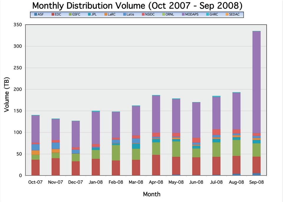
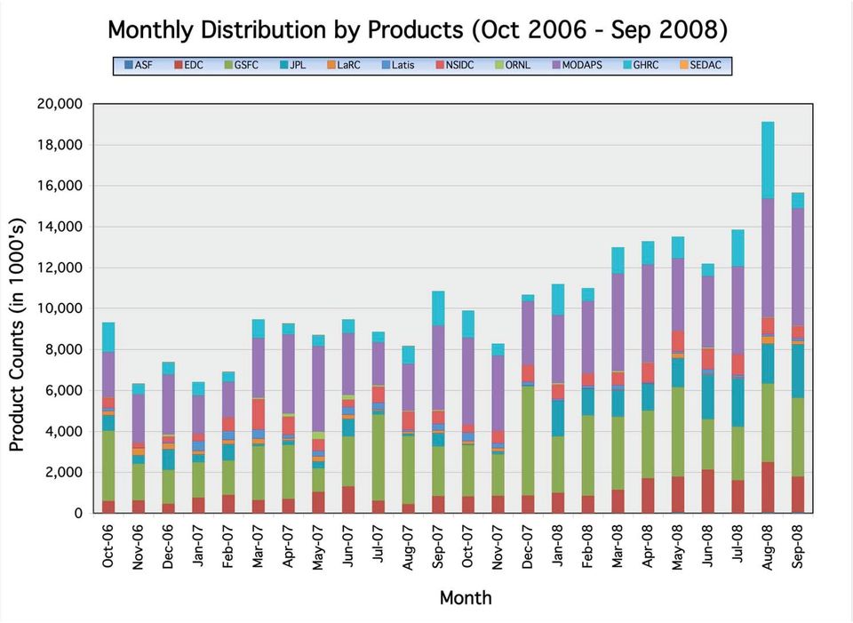
9 EOSDIS Products Delivered: 1996 thru Sept 2008 (in Millions) ,263 K FY96 FY97 FY98 FY99 FY00 FY01 FY02 FY03 FY04 FY05 FY06 FY07 FY08 to date Sep 9

10 10

11 11
12 12
13 13

14 FY2008 Data Center Web Activity Sep 2008 ASF GESDISC LARC LPDAAC MODAPS NSIDC ORNL PODAAC 80,000 70,000 Unique Visitors Previous Month Current Month Previous Year 60,000 by Month Total Visitors Aug 08 66,439 Sep 08 97,026 Sep 07 58,338 Number of Visitors 50,000 40,000 30,000 FY to date Total Visitors Repeat Visitors 690, , , , , ,372 20,000 10, FY08 Repeat Web Visitors by end of September Number of Visits 14

15 NASA Earth Science Interoperable Data Architecture 15

16 Earth Science Data Discovery Global Change Master Directory (GCMD) ( //gcmd.nasa.gov) Provides a catalog ad portal for data discovery of NASA and other publicly available environmental data and services. ECHO (EOS Clearing House) Provides a data granule-level metadata for all NASA EOS data. ECHO enables common searches of earth science relevant data across all NASA on-line data access systems. XML-based structure allows more easy mapping between differing metadata formats. Transition to the new Warehouse Inventory Search Tool (WIST) Individual DAAC Tools OGC Tools Collaboration Tools and Portals 16

17 - Over 17,000 metadata records - Over 1,000 worldwide data providers - Average 5 million visits per month 17

18 ECHO Status Holdings and Partners Current Holdings Collections 2,674 Granules 85 million Browse 28 million Data Partners Operational Public: 10 Test: 1 (GHRC) Client Partners Operational 3 (WIST, SNOW-I, ESA) In evaluation or test2 (WECHO, AQUA) Active development1 (WISRD) 18
 In evaluation or test2 (WECHO, AQUA) Active")
19 2008 ECHO Improvements Synchronize TT/NCR prioritization scheme with ECS Defect tracking & prioritization Severity 1 escalation: are worked 24x7 until fixed for ECHO Upgraded Support 8:00am 7:00pm EST Operations support 24 Hour response time to echo@echo messages 48 Hour notification prior to Operational planned downtime Data Integrity fixes include better ingest validation; spatial representations fixed and enforced data rules Performance & scalability enhancement Ingest performance improved from 9K events/hr to 40K events/hr Recovery & failover Deployed a new redundant WIST system (recovery in under 15 mins) Data corruption or system corruption recovery in under 6 hrs 19
 Data corruption or system corruption recovery in")
20 EOSDIS ACSI Customer Satisfaction Survey EOSDIS sponsors an annual independent customer survey in conjunction with the American Customer Satisfaction Index (ACSI). EOSDIS consistently exceeds the Federal Government average Ratings in the mid to upper 70s are considered very good by the rating organization, the CFI Group Federal Government (Overall) NASA EOSDIS NASA EOSDIS E-Business News & Information (Public/Private Sectors)
 2008 67 NASA EOSDIS 77 2008 NASA EOSDIS 2007 75")
21 ACSI and EOSDIS Metrics System ESDIS will coordinate the actions to address the 2008 ACSI survey results and determine focus areas for the next year Work with DAACs to examine specific results and actions Get the message out to users that we are looking at the ACSI results and have a corresponding action plan to address the key areas identified for improvement ESDIS provides CFI Group a list of addresses collected in the previous 12 months (37,229 in 2008; 23,827 in 2007) CFI received 2,763 surveys in 2008 (2291 in 2007) ESDIS will continue to develop the metrics system (EMS) Provide opportunity to define new metrics on utilization of data documentation, data search, and data formatting services Sponsor use of NetInsight Web tracking for finding common access patterns, guiding web page re-organization, and enabling more efficient access to data and documentation 21
22 Data Management Coordination Work to facilitate core (DAAC-SIPS) and community (MEaSURES( MEaSURES) ) involvement in NASA ES data Two meetings: system engineering & management Upcoming focus is Data Center-SIPS interaction scheduled for November 2008 Regular telecons WIKI forums Support the Earth Science Data Systems Working Group (ESDSWG) and ESIP Federation Standards involvement - ex: HDF, Metadata, FGDC, Process definition 22
23 23
24 Operating Budgets and Plans Every year DAACs and ESDIS prepare a work plan and operations budget The work plan addresses contract tasks ESDIS looks for activities that will improve data center operations while maintaining a high level of customer satisfaction Budgets 5 years for input to NASA s s Program Operations Plans FY submission prepared for NASA Science Mission Directorate Program review Apr 2009 Annual excel spreadsheet entitled the snowball Due January February time frame Details mission/cost-work function per fiscal year» (e.g., ops, engineering, equipment traceable to contract WBS) Heritage from 1990 s Current budget projection is stable (i.e., flat) New mission data costs added as approved by ESDIS 24
25 ESDIS Project Contacts Dawn Lowe, Project Manager Jeanne Behnke, Science Operations Office Manager John Moses, Science Operations Office Please feel free to contact any of us with suggestions or comments! 25
Satellite'&'NASA'Data'Intro'
 Satellite'&'NASA'Data'Intro' Research'vs.'Opera8ons' NASA':'Research'satellites' ' ' NOAA/DoD:'Opera8onal'Satellites' NOAA'Polar'Program:'NOAA>16,17,18,19,NPP' Geosta8onary:'GOES>east,'GOES>West' DMSP'series:'SSM/I,'SSMIS'
NASA Earth System Science: Structure and data centers
 SUPPLEMENT MATERIALS NASA Earth System Science: Structure and data centers NASA http://nasa.gov/ NASA Mission Directorates Aeronautics Research Exploration Systems Science http://nasascience.nasa.gov/
Satellite Products and Dissemination: Visualization and Data Access
 Satellite Products and Dissemination: Visualization and Data Access Gregory Leptoukh GES DISC, NASA GSFC Dana Ostrenga GES DISC, NASA GSFC Introduction The Goddard Earth Sciences Data and Information Services
The NASA NEESPI Data Portal to Support Studies of Climate and Environmental Changes in Non-boreal Europe
 The NASA NEESPI Data Portal to Support Studies of Climate and Environmental Changes in Non-boreal Europe Suhung Shen NASA Goddard Space Flight Center/George Mason University Gregory Leptoukh, Tatiana Loboda,
NASA's Earth Observing Data and Information System (EOSDIS)
") NASA's Earth Observing Data and Information System (EOSDIS) Copernicus Big Data Workshop 13 March 2014 Brussels, Belgium Kevin Murphy EOSDIS System Architect NASA Goddard Space Flight Center Topics to
NASA's Earth Observing Data and Information System (EOSDIS) Copernicus Big Data Workshop 13 March 2014 Brussels, Belgium Kevin Murphy EOSDIS System Architect NASA Goddard Space Flight Center Topics to
Obtaining and Processing MODIS Data
 Obtaining and Processing MODIS Data MODIS is an extensive program using sensors on two satellites that each provide complete daily coverage of the earth. The data have a variety of resolutions; spectral,
Clouds and the Energy Cycle
 August 1999 NF-207 The Earth Science Enterprise Series These articles discuss Earth's many dynamic processes and their interactions Clouds and the Energy Cycle he study of clouds, where they occur, and
EED Task Order. Contract: NNG10HP02C Contractor: Raytheon Task Type:
 EED Task Order Title: Studies CMR Phase 0 No-Cost Extension Task Number: 9 Rev 15 Originator: Marinelli Effective Date: Dec 11, 2013 ESDIS POC: Marinelli Task Estimate Cost and Maximum Available Fee Estimate
Asynchronous Data Mining Tools at the GES-DISC
 Asynchronous Data Mining Tools at the GES-DISC Long B. Pham, Stephen W. Berrick, Christopher S. Lynnes and Eunice K. Eng NASA Goddard Space Flight Center Distributed Active Archive Center Introduction
NASA s Big Data Challenges in Climate Science
 NASA s Big Data Challenges in Climate Science Tsengdar Lee, Ph.D. High-end Computing Program Manager NASA Headquarters Presented at IEEE Big Data 2014 Workshop October 29, 2014 1 2 7-km GEOS-5 Nature Run
Data Management Framework for the North American Carbon Program
 Data Management Framework for the North American Carbon Program Bob Cook, Peter Thornton, and the Steering Committee Image courtesy of NASA/GSFC NACP Data Management Planning Workshop New Orleans, LA January
Joint Polar Satellite System (JPSS)
") Joint Polar Satellite System (JPSS) John Furgerson, User Liaison Joint Polar Satellite System National Environmental Satellite, Data, and Information Service National Oceanic and Atmospheric Administration
Joint Polar Satellite System (JPSS) John Furgerson, User Liaison Joint Polar Satellite System National Environmental Satellite, Data, and Information Service National Oceanic and Atmospheric Administration
Welcome to NASA Applied Remote Sensing Training (ARSET) Webinar Series
 Webinar Series") Welcome to NASA Applied Remote Sensing Training (ARSET) Webinar Series Introduction to Remote Sensing Data for Water Resources Management Course Dates: October 17, 24, 31 November 7, 14 Time: 8-9 a.m.
Welcome to NASA Applied Remote Sensing Training (ARSET) Webinar Series Introduction to Remote Sensing Data for Water Resources Management Course Dates: October 17, 24, 31 November 7, 14 Time: 8-9 a.m.
CALIPSO, CloudSat, CERES, and MODIS Merged Data Product
 CALIPSO, CloudSat, CERES, and MODIS Merged Data Product Seiji Kato 1, Sunny Sun-Mack 2, Walter F. Miller 2, Fred G. Rose 2, and Victor E. Sothcott 2 1 NASA Langley Research Center 2 Science and Systems
EXPLORING NASA AND ESA ATMOSPHERIC DATA USING GIOVANNI, THE ONLINE VISUALIZATION AND ANALYSIS TOOL
 EXPLORING NASA AND ESA ATMOSPHERIC DATA USING GIOVANNI, THE ONLINE VISUALIZATION AND ANALYSIS TOOL Gregory Leptoukh (1), Steve Cox (2), John Farley (2), Arun Gopalan (2), Jianping Mao (2), Stephen Berrick
Report to 8 th session of OOPC. By Dr. Alan R. Thomas, Director, GCOS Secretariat
 Report to 8 th session of OOPC By Dr. Alan R. Thomas, Director, GCOS Secretariat The GCOS is comprised of the climate components of the domain based observing systems including both satellite and in situ
FlowViewer. Maintaining NASA s Earth Science Traffic Situational Awareness
 FlowViewer Maintaining NASA s Earth Science Traffic Situational Awareness Graphic credit: Arizona/New Mexico Fire Imagery, USDA Forest Service; Remote Sensing Application Center; Image acquired from Aqua
CERES Edition 2 & Edition 3 Cloud Cover, Cloud Altitude and Temperature
 CERES Edition 2 & Edition 3 Cloud Cover, Cloud Altitude and Temperature S. Sun-Mack 1, P. Minnis 2, Y. Chen 1, R. Smith 1, Q. Z. Trepte 1, F. -L. Chang, D. Winker 2 (1) SSAI, Hampton, VA (2) NASA Langley
GCOS science conference, 2 Mar. 2016, Amsterdam. Japan Meteorological Agency (JMA)
") GCOS science conference, 2 Mar. 2016, Amsterdam Status of Surface Radiation Budget Observation for Climate Nozomu Ohkawara Japan Meteorological Agency (JMA) Contents 1. Background 2. Status t of surface
GCOS science conference, 2 Mar. 2016, Amsterdam Status of Surface Radiation Budget Observation for Climate Nozomu Ohkawara Japan Meteorological Agency (JMA) Contents 1. Background 2. Status t of surface
Cloud Computing @ JPL Science Data Systems
 Cloud Computing @ JPL Science Data Systems Emily Law, GSAW 2011 Outline Science Data Systems (SDS) Space & Earth SDSs SDS Common Architecture Components Key Components using Cloud Computing Use Case 1:
Forest Fire Information System (EFFIS): Rapid Damage Assessment
: Rapid Damage Assessment") Forest Fire Information System (EFFIS): Fire Danger D Rating Rapid Damage Assessment G. Amatulli, A. Camia, P. Barbosa, J. San-Miguel-Ayanz OUTLINE 1. Introduction: what is the JRC 2. What is EFFIS 3.
Forest Fire Information System (EFFIS): Fire Danger D Rating Rapid Damage Assessment G. Amatulli, A. Camia, P. Barbosa, J. San-Miguel-Ayanz OUTLINE 1. Introduction: what is the JRC 2. What is EFFIS 3.
The Arctic Observing Network and its Data Management Challenges Florence Fetterer (NSIDC/CIRES/CU), James A. Moore (NCAR/EOL), and the CADIS team
, James A. Moore (NCAR/EOL), and the CADIS team") The Arctic Observing Network and its Data Management Challenges Florence Fetterer (NSIDC/CIRES/CU), James A. Moore (NCAR/EOL), and the CADIS team Photo courtesy Andrew Mahoney NSF Vision What is AON? a
The Arctic Observing Network and its Data Management Challenges Florence Fetterer (NSIDC/CIRES/CU), James A. Moore (NCAR/EOL), and the CADIS team Photo courtesy Andrew Mahoney NSF Vision What is AON? a
Giovanni: A System for Rapid Access, Visualization and Analysis of Earth Science Data Online
 Giovanni: A System for Rapid Access, Visualization and Analysis of Earth Science Data Online Suhung Shen *, H. Rui, Z. Liu, T Zhu, L. Lu, S. Berrick, G. Leptoukh, W. Teng, J. Acker, J. Johnson, S. P. Ahmad,
Norwegian Satellite Earth Observation Database for Marine and Polar Research http://normap.nersc.no USE CASES
 Norwegian Satellite Earth Observation Database for Marine and Polar Research http://normap.nersc.no USE CASES The NORMAP Project team has prepared this document to present functionality of the NORMAP portal.
Overview of NASA Applied Remote Sensing Training Program on Water Resources and Disaster Management
 Overview of NASA Applied Remote Sensing Training Program on Water Resources and Disaster Management ARSET Applied Remote SEnsing Training A project of NASA Applied Sciences Outline About ARSET ARSET Trainings
The Balance of Power in the Earth-Sun System
 NASA Facts National Aeronautics and Space Administration www.nasa.gov The Balance of Power in the Earth-Sun System The Sun is the major source of energy for Earth s oceans, atmosphere, land, and biosphere.
TECHNICAL REPORTS. Authors: Tatsuhiro Noguchi* and Takaaki Ishikawa*
 Application and Evaluation of Observation Data by Advanced Microwave Scanning Radiometer 2 Achievement of World s Top-Class Microwave Radiometer AMSR Series Authors: Tatsuhiro Noguchi* and Takaaki Ishikawa*
Temporal variation in snow cover over sea ice in Antarctica using AMSR-E data product
 Temporal variation in snow cover over sea ice in Antarctica using AMSR-E data product Michael J. Lewis Ph.D. Student, Department of Earth and Environmental Science University of Texas at San Antonio ABSTRACT
International coordination for continuity and interoperability: a CGMS perspective
 International coordination for continuity and interoperability: a CGMS perspective Peng Zhang, CGMS WG-III Co-Chair NSMC/CMA In Cooperation with Suzanne Hilding, CGMS WG-III Co-Chair OPPA/NESDIS/NOAA 1
Data Management for the North American Carbon Program
 Image courtesy of NASA/GSFC Data Management for the North American Carbon Program Bob Cook, Eric Sundquist, Tom Boden,, and Peter Thornton RS in NACP Workshop Missoula, MT August 20, 2004 NACP Data and
Marcus A. Watkins Director of the Joint Agency Satellite Division, Science Mission Directorate, NASA HQ, Washington DC
 Marcus A. Watkins Director of the Joint Agency Satellite Division, Science Mission Directorate, NASA HQ, Washington DC Leads the Joint Agency Satellite Division (JASD) at NASA HQ in Washington, DC and
Jessica Blunden, Ph.D., Scientist, ERT Inc., Climate Monitoring Branch, NOAA s National Climatic Data Center
 Kathryn Sullivan, Ph.D, Acting Under Secretary of Commerce for Oceans and Atmosphere and NOAA Administrator Thomas R. Karl, L.H.D., Director,, and Chair of the Subcommittee on Global Change Research Jessica
Huai-Min Zhang & NOAAGlobalTemp Team
 Improving Global Observations for Climate Change Monitoring using Global Surface Temperature (& beyond) Huai-Min Zhang & NOAAGlobalTemp Team NOAA National Centers for Environmental Information (NCEI) [formerly:
Long Term Preservation of Earth Observation Data
 Long Term Preservation of Earth Observation Data QA4EO Workshop RAL, October 18-20 th 2011 Mirko Albani and Bojan Bojkov* (ESA/ESRIN) Page 1 Outline Earth Observation data preservation: the need and the
Observed Cloud Cover Trends and Global Climate Change. Joel Norris Scripps Institution of Oceanography
 Observed Cloud Cover Trends and Global Climate Change Joel Norris Scripps Institution of Oceanography Increasing Global Temperature from www.giss.nasa.gov Increasing Greenhouse Gases from ess.geology.ufl.edu
Solar Irradiance Variability
 Solar Radiative Output and its Variability Claus Frölich and Judith Lean Preethi Ganapathy November 22, 2005 Solar Irradiance Variability Historical Investigations Contemporary Investigations Limitations
Development of an Integrated Data Product for Hawaii Climate
 Development of an Integrated Data Product for Hawaii Climate Jan Hafner, Shang-Ping Xie (PI)(IPRC/SOEST U. of Hawaii) Yi-Leng Chen (Co-I) (Meteorology Dept. Univ. of Hawaii) contribution Georgette Holmes
FRENCH ARCTIC INITIATIVE SCIENTIFIC PRIORITIES
 FRENCH ARCTIC INITIATIVE SCIENTIFIC PRIORITIES J.J. Pangrazi / Biosphoto J.J. Pangrazi / Biosphoto Conference audience Edouard Bard introductory lecture Dr. Denis-Didier Rousseau (CNRS Senior Research
AUTOMATED DEM VALIDATION USING ICESAT GLAS DATA INTRODUCTION
 AUTOMATED DEM VALIDATION USING ICESAT GLAS DATA Mary Pagnutti Robert E. Ryan Innovative Imaging and Research Corp. Building 1103, Suite 140C Stennis Space Center, MS 39529 [email protected] [email protected]
Remote Sensing Satellite Information Sheets Geophysical Institute University of Alaska Fairbanks
 Remote Sensing Satellite Information Sheets Geophysical Institute University of Alaska Fairbanks ASTER Advanced Spaceborne Thermal Emission and Reflection Radiometer AVHRR Advanced Very High Resolution
Radiative effects of clouds, ice sheet and sea ice in the Antarctic
 Snow and fee Covers: Interactions with the Atmosphere and Ecosystems (Proceedings of Yokohama Symposia J2 and J5, July 1993). IAHS Publ. no. 223, 1994. 29 Radiative effects of clouds, ice sheet and sea
II. Related Activities
 (1) Global Cloud Resolving Model Simulations toward Numerical Weather Forecasting in the Tropics (FY2005-2010) (2) Scale Interaction and Large-Scale Variation of the Ocean Circulation (FY2006-2011) (3)
Fundamentals of Climate Change (PCC 587): Water Vapor
: Water Vapor") Fundamentals of Climate Change (PCC 587): Water Vapor DARGAN M. W. FRIERSON UNIVERSITY OF WASHINGTON, DEPARTMENT OF ATMOSPHERIC SCIENCES DAY 2: 9/30/13 Water Water is a remarkable molecule Water vapor
Fundamentals of Climate Change (PCC 587): Water Vapor DARGAN M. W. FRIERSON UNIVERSITY OF WASHINGTON, DEPARTMENT OF ATMOSPHERIC SCIENCES DAY 2: 9/30/13 Water Water is a remarkable molecule Water vapor
JPL ANOMALY ISSUES. Henry B. Garrett Jet Propulsion Laboratory California Institute of Technology Pasadena, CA, 91109
 JPL ANOMALY ISSUES Henry B. Garrett Pasadena, CA, 91109 Space Weather Anomaly Concerns for JPL Robotic Mission AGENDA Overview of Space Weather Anomalies on JPL Missions Space Weather Products used by
SPARC Data Center. www.sparc.sunysb.edu. Peter Love Marvin Geller Institute for Terrestrial and Planetary Atmospheres Stony Brook University
 SPARC Data Center www.sparc.sunysb.edu Peter Love Marvin Geller Institute for Terrestrial and Planetary Atmospheres Stony Brook University SPARC Data Centre Overview Exists to facilitate data exchange
TRMM and Other Global Precipitation Products and Data Services at NASA GES DISC. Zhong Liu George Mason University and NASA GES DISC
 TRMM and Other Global Precipitation Products and Data Services at NASA GES DISC Zhong Liu George Mason University and NASA GES DISC Outline Introduction of data and services at GES DISC TRMM and other
From Whitehall to orbit and back again: using space in government
 From Whitehall to orbit and back again: using space in government 18 th June 2014 Bristol 25 th June 2014 Liverpool 3 rd July 2014 -Newcastle Space for Smarter Government Programme ([email protected])
Cloud detection and clearing for the MOPITT instrument
 Cloud detection and clearing for the MOPITT instrument Juying Warner, John Gille, David P. Edwards and Paul Bailey National Center for Atmospheric Research, Boulder, Colorado ABSTRACT The Measurement Of
Update on EUMETSAT ocean colour services. Ewa J. Kwiatkowska
 Update on EUMETSAT ocean colour services Ewa J. Kwiatkowska 1 st International Ocean Colour Science meeting, 6 8 May, 2013 EUMETSAT space data provider for operational oceanography Operational data provider
Satellite Measurements of Solar Spectral Irradiance
 Satellite Measurements of Solar Spectral Irradiance LASP University of Colorado [email protected] March 2006 1 Talk Outline Motivation for Solar Spectral Irradiance solar energy input climate
USGS EOS SYSTEMS ENGINEERING MANAGEMENT PLAN (SEMP)
") Department of the Interior U.S. Geological Survey USGS EOS SYSTEMS ENGINEERING MANAGEMENT PLAN (SEMP) September 2013 Executive Summary This Systems Engineering Management Plan (SEMP) outlines the engineering
Department of the Interior U.S. Geological Survey USGS EOS SYSTEMS ENGINEERING MANAGEMENT PLAN (SEMP) September 2013 Executive Summary This Systems Engineering Management Plan (SEMP) outlines the engineering
PART 1. Representations of atmospheric phenomena
 PART 1 Representations of atmospheric phenomena Atmospheric data meet all of the criteria for big data : they are large (high volume), generated or captured frequently (high velocity), and represent a
Cloud-based Geospatial Data services and analysis
 Cloud-based Geospatial Data services and analysis Xuezhi Wang Scientific Data Center Computer Network Information Center Chinese Academy of Sciences 2014-08-25 Outlines 1 Introduction of Geospatial Data
Measurements Of Pollution In The Troposphere (MOPITT) NASA Langley ASDC Data Collection Guide
 NASA Langley ASDC Data Collection Guide") Measurements Of Pollution In The Troposphere (MOPITT) NASA Langley ASDC Data Collection Guide Summary: The MOPITT data sets are designed to measure carbon monoxide (CO) and methane (CH 4 ) concentrations
Measurements Of Pollution In The Troposphere (MOPITT) NASA Langley ASDC Data Collection Guide Summary: The MOPITT data sets are designed to measure carbon monoxide (CO) and methane (CH 4 ) concentrations
Interagency Science Working Group. National Archives and Records Administration
 Interagency Science Working Group 1 National Archives and Records Administration Establishing Trustworthy Digital Repositories: A Discussion Guide Based on the ISO Open Archival Information System (OAIS)
UCAR Trustee Candidate Kenneth Bowman
 UCAR Trustee Candidate Kenneth Bowman The Member's Nominating Committee is pleased to present Dr. Kenneth Bowman from Texas A&M University as a candidate for the UCAR Board of Trustees. Dr. Bowman is currently
Curriculum Material and Activities of Climate Education:
 Curriculum Material and Activities of Climate Education: Education Link Website Union of Concerned Scientists develop the global warming: Early Warning Signs Map a science-based world map depicting the
Directorate for Geosciences
 NSF Regional Grants Conference Salt Lake City, Utah Directorate for Geosciences Sonia Esperança, Ph.D. Division of Earth Sciences [email protected] The Mission of the Directorate for Geosciences Support
Environmental Data Services for Delaware:
 Environmental Data Services for Delaware: Serving Emergency Responders, Planners, and Researchers Network Delaware Day November 6, 2013 Overview Operational Data Services More than just research DEOS and
A SURVEY OF CLOUD COVER OVER MĂGURELE, ROMANIA, USING CEILOMETER AND SATELLITE DATA
 Romanian Reports in Physics, Vol. 66, No. 3, P. 812 822, 2014 ATMOSPHERE PHYSICS A SURVEY OF CLOUD COVER OVER MĂGURELE, ROMANIA, USING CEILOMETER AND SATELLITE DATA S. STEFAN, I. UNGUREANU, C. GRIGORAS