Francisco Edson M. Gomes Geologist CPRM Geological Survey of Brazil
|
|
|
- Esther Lyons
- 8 years ago
- Views:
Transcription

1 Francisco Edson M. Gomes Geologist CPRM Geological Survey of Brazil


2 Area

3 BACKGROUND The Atlas of the South Atlantic Ocean Data organized in GIS was designed by the Geological Survey of Brazil (CPRM) and the International Seabed Authority (ISA). It integrates all available data on the geology, mineral resources, environmental issues, and geographic information of the South and Equatorial Atlantic Ocean.

4 Products GIS PROJECT Structural map MORPHOTECTONIC MAP

5 Free-Air Anomalies Plate Boundaries Vo l c a n o e s Cobaltiferous Crusts Ocean-Continent Transitions Polymetallic Sulphides Age of oceanic lithosphere Salt boundary Structural elements ANGOLA-BRAZIL GEOTRANSECT DATA DIAPIR ISOPACHS OCEANIC TOP OF BASEMENT GRID EARTHQUAKE EPICENTERS MINERAL OCCURRENCES SLAB DEPTHS GEBCO_08 GRID SURFICIAL SEDIMENTS FACIES (Brazilian Continental Shelf) Heat Flow Bouguer Anomalies Hydrothermal vents Seamount biological data Sediment Thickness Offshore brazilian protected areas Large Igneous Provinces - LIPs AXES OF ACCRETIONARY RIDGES Isopachs Morphotectonic features POTENTIAL MINERAL RESOURCES


6 Data Source: Muller, R. D., M. Sdrolias, C. Gaina, and W. R. Roest (2008). Age, spreading rates, and spreading asymmetry of the world's ocean crust, Geochem. Geophys. Geosyst., 9, Q04006, doi: /2007gc Geoprocessing and geological adjustments: Francisco Edson M. Gomes Geological Survey of Brazil


7 Tectonic elements Fracture zone Compiled by: Francisco Edson M. Gomes Geological Survey of Brazil. COB Continental Slope

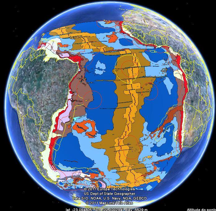
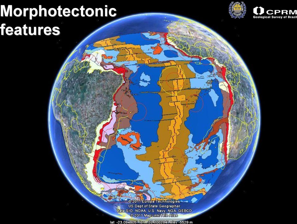
8 Morphotectonic features


9 Source of grid: Geoprocessing: Francisco Edson M. Gomes

, Geoprocessing: Francisco Edson M.")
10 Free-air anomalies Source of grid: Sandwell, D. T., and W. H. F. Smith (2009), Geoprocessing: Francisco Edson M. Gomes


, Correção")
11 Bouguer anomalies Source of grid: Sandwell, D. T., and W. H. F. Smith (2009), Correção Bouguer: Ivo Pessanha
, Correção")

12 Oceanic Top-Basement Source of grid: Gebco, NGDC,NESDIS, NOAA, U.S Department of Commerce Geoprocessing: Francisco Edson M. Gomes


13 Slope Image derived from Gebco-08 grid: Geoprocessing: Francisco Edson M. Gomes


14 Magnetic anomalies Image derived from EMAG2 grid available at and EMAG2 (2-arc-minute resolution) Geoprocessing: Francisco Edson M. Gomes
")

15 Sediment thickness Source of grid: National Geophysical Data Center, NESDIS, NOAA, U.S. Department of Commerce Geoprocessing: Francisco Edson M. Gomes


16 Heat flow Source of csv files: lgeoprocessing: Francisco Edson M. Gomes

17 Contours of sediment thickness Source of grid: National Geophysical Data Center, NESDIS, NOAA, U.S. Department of Commerce Geoprocessing: Francisco Edson M. Gomes


18 Source: PETROBRAS Status: Available only on the coast of Brazil


19 Large Igneous Provinces Serra Leone Rise Parana Flood Basalt Vitoria-Trindade Ridge Etendeka Volcanism Status: completed Georgia Rise Maritime Source: University of Texas Institute of Geophysics. Modified by Francisco Edson M. Gomes Continental


20 Source: University of Texas Institute of Geophysics Modified by Francisco Edson M. Gomes Sedimentary basins Status: missing complementary data on African side


21 Source: PLATES Project, University of Texas Institute of Geophysics. Modified by Francisco Edson M. Gomes Present day plate tectonic boundaries South American Plate African Plate Scotia Sea Plate South Sandwich Microplate Antarctic Plate
22 Mineral Resources Polymetallic Nodules Ferromanganese crust occurences
23 Drilling sites Deep Sea Drilling Project (DSDP) Ocean Drilling Program (ODP)

24 Hydrothermal vent Volcano Hot spot Sources: Smithsonian Institution and ISA


25 Status: completed Source: USGS

26 -15-10
27 -15-10
28 Samples collected between 1981 and 1987

29


30 -15-10
31 -10-15

32 -10-15
33 -10-15

34 -10-15
35 Francisco Edson M. Gomes
Earth Science Chapter 14 Section 2 Review
 Name: Class: Date: Earth Science Chapter 14 Section Review Multiple Choice Identify the choice that best completes the statement or answers the question. 1. Which of the following is NOT one of the three
How Did These Ocean Features and Continental Margins Form?
 298 10.14 INVESTIGATION How Did These Ocean Features and Continental Margins Form? The terrain below contains various features on the seafloor, as well as parts of three continents. Some general observations
DYNAMIC CRUST: Unit 4 Exam Plate Tectonics and Earthquakes
 DYNAMIC CRUST: Unit 4 Exam Plate Tectonics and Earthquakes NAME: BLOCK: DATE: 1. Base your answer to the following question on The block diagram below shows the boundary between two tectonic plates. Which
TECTONICS ASSESSMENT
 Tectonics Assessment / 1 TECTONICS ASSESSMENT 1. Movement along plate boundaries produces A. tides. B. fronts. C. hurricanes. D. earthquakes. 2. Which of the following is TRUE about the movement of continents?
Plate Tectonics Practice Questions and Answers Revised August 2007
 Plate Tectonics Practice Questions and Answers Revised August 2007 1. Please fill in the missing labels. 2. Please fill in the missing labels. 3. How many large plates form the outer shell of the earth?
Regents Questions: Plate Tectonics
 Earth Science Regents Questions: Plate Tectonics Name: Date: Period: August 2013 Due Date: 17 Compared to the oceanic crust, the continental crust is (1) less dense and more basaltic (3) more dense and
Chapter Overview. Bathymetry. Measuring Bathymetry. Echo Sounding Record. Measuring Bathymetry. CHAPTER 3 Marine Provinces
 Chapter Overview CHAPTER 3 Marine Provinces The study of bathymetry charts ocean depths and ocean floor topography. Echo sounding and satellites are efficient bathymetric tools. Most ocean floor features
Transform Boundaries
 Lecture 7 Plates and Mantle Plumes Transform Boundaries Transform boundaries occur where one segment of rigid lithosphere slides horizontally past another in response to stresses in the lithosphere. The
II. Earth Science (Geology) Section (9/18/2013)
 Section (9/18/2013)") EAPS 100 Planet Earth Lecture Topics Brief Outlines II. Earth Science (Geology) Section (9/18/2013) 1. Interior of the Earth Learning objectives: Understand the structure of the Earth s interior crust,
EAPS 100 Planet Earth Lecture Topics Brief Outlines II. Earth Science (Geology) Section (9/18/2013) 1. Interior of the Earth Learning objectives: Understand the structure of the Earth s interior crust,
Chapter 2. Plate Tectonics. Plate Tectonics: Learning Goals
 Plate Tectonics Chapter 2 Interactions at depend on the direction of relative plate motion and the type of crust. Which kind of plate boundary is associated with Earthquake activity? A. Divergent Boundary
Plate Tectonics: Big Ideas. Plate Tectonics. Plate Tectonics. The unifying concept of the Earth sciences.
 Plate Tectonics: Big Ideas Our understanding of Earth is continuously refined. Earth s systems are dynamic; they continually react to changing influences from geological, hydrological, physical, chemical,
Plate Tectonics: Ridges, Transform Faults and Subduction Zones
 Plate Tectonics: Ridges, Transform Faults and Subduction Zones Goals of this exercise: 1. review the major physiographic features of the ocean basins 2. investigate the creation of oceanic crust at mid-ocean
Continental Drift, Sea Floor Spreading and Plate Tectonics
 Page 1 of 13 EENS 1110 Tulane University Physical Geology Prof. Stephen A. Nelson Continental Drift, Sea Floor Spreading and Plate Tectonics This page last updated on 26-Aug-2015 Plate Tectonics is a theory
4. Plate Tectonics II (p. 46-67)
") 4. Plate Tectonics II (p. 46-67) Seafloor Spreading In the early 1960s, samples of basaltic ocean crust were dredged up from various locations across the ocean basins. The samples were then analyzed to
4. Plate Tectonics II (p. 46-67) Seafloor Spreading In the early 1960s, samples of basaltic ocean crust were dredged up from various locations across the ocean basins. The samples were then analyzed to
1. The diagram below shows a cross section of sedimentary rock layers.
 1. The diagram below shows a cross section of sedimentary rock layers. Which statement about the deposition of the sediments best explains why these layers have the curved shape shown? 1) Sediments were
Plate tectonics states that the Earth's crust and upper mantle are broken into sections, called plates.
 Notes on Plate Tectonics Plate tectonics states that the Earth's crust and upper mantle are broken into sections, called plates. These plates move around the mantle. Plates are composed of the crust and
Plate Tectonics. Plate Tectonics The unifying concept of the Earth sciences. Continental Drift
 Plate Tectonics The unifying concept of the Earth sciences. The outer portion of the Earth is made up of about 20 distinct plates (~ 100 km thick), which move relative to each other This motion is what
Geol 101: Physical Geology PAST EXAM QUESTIONS LECTURE 4: PLATE TECTONICS II
 Geol 101: Physical Geology PAST EXAM QUESTIONS LECTURE 4: PLATE TECTONICS II 4. Which of the following statements about paleomagnetism at spreading ridges is FALSE? A. there is a clear pattern of paleomagnetic
Syllabus and Preparation for 2013 Online Marine Geology
 Syllabus and Preparation for 2013 Online Marine Geology During the 2013 Marine Geology class, students will be required to read course material, complete two exams, present once and write one library research
Plate Tectonics. Introduction. Boundaries between crustal plates
 Plate Tectonics KEY WORDS: continental drift, seafloor spreading, plate tectonics, mid ocean ridge (MOR) system, spreading center, rise, divergent plate boundary, subduction zone, convergent plate boundary,
Plate Tectonics Chapter 2
 Plate Tectonics Chapter 2 Does not include complete lecture notes. Continental drift: An idea before its time Alfred Wegener First proposed his continental drift hypothesis in 1915 Published The Origin
ES Chapter 10 Review. Name: Class: Date: Multiple Choice Identify the choice that best completes the statement or answers the question.
 Name: Class: Date: ES Chapter 10 Review Multiple Choice Identify the choice that best completes the statement or answers the question. 1. Scientists used the pattern of alternating normal and reversed
Georgia Performance Standards Framework for Science Grade 6. Unit Organizer: Geology: Inside the Earth (Approximate Time: 7 Weeks)
") The following instructional plan is part of a GaDOE collection of Unit Frameworks, Performance Tasks, examples of Student Work, and Teacher Commentary. Many more GaDOE approved instructional plans are
The following instructional plan is part of a GaDOE collection of Unit Frameworks, Performance Tasks, examples of Student Work, and Teacher Commentary. Many more GaDOE approved instructional plans are
Interactive Plate Tectonics
 Interactive Plate Tectonics Directions: Go to the following website and complete the questions below. http://www.learner.org/interactives/dynamicearth/index.html How do scientists learn about the interior
Plate Tectonics. Earth, 9 th edition Chapter 2
 1 Plate Tectonics Earth, 9 th edition Chapter 2 2 3 4 5 6 7 8 9 10 11 12 13 14 15 16 Plate Tectonics: summary in haiku form Alfred Wegener gave us Continental Drift. Fifty years later... Continental Drift
Rocks and Plate Tectonics
 Name: Class: _ Date: _ Rocks and Plate Tectonics Multiple Choice Identify the choice that best completes the statement or answers the question. 1. What is a naturally occurring, solid mass of mineral or
Chapter 8: Plate Tectonics -- Multi-format Test
 Name: Class: Date: ID: A Chapter 8: Plate Tectonics -- Multi-format Test Modified True/False Indicate whether the statement is true or false. If false, change the identified word or phrase to make the
Study Guide Questions Earth Structure and Plate Tectonics
 Study Guide Questions Earth Structure and Plate Tectonics What evidence did Alfred Wegener present in 1912 to support the idea of continental drift? Why did most geologists at the time dismiss Wegener
The Next Generation Science Standards (NGSS) Correlation to. EarthComm, Second Edition. Project-Based Space and Earth System Science
 Correlation to. EarthComm, Second Edition. Project-Based Space and Earth System Science") The Next Generation Science Standards (NGSS) Achieve, Inc. on behalf of the twenty-six states and partners that collaborated on the NGSS Copyright 2013 Achieve, Inc. All rights reserved. Correlation to,
The Next Generation Science Standards (NGSS) Achieve, Inc. on behalf of the twenty-six states and partners that collaborated on the NGSS Copyright 2013 Achieve, Inc. All rights reserved. Correlation to,
Tectonic plates push together at convergent boundaries.
 KEY CONCEPT Plates converge or scrape past each other. BEFORE, you learned Plates move apart at divergent boundaries In the oceans, divergent boundaries mark where the sea floor spreads apart On land,
Plate Tectonics Lab. Continental Drift. The Birth of Plate Tectonics
 Plate Tectonics Lab Continental Drift Take a look at a globe sometime and observe the remarkable fit between South America and Africa. Could they have, in fact, been connected? During the 19th and early
Hot Spots & Plate Tectonics
 Hot Spots & Plate Tectonics Activity I: Hawaiian Islands Procedures: Use the map and the following information to determine the rate of motion of the Pacific Plate over the Hawaiian hot spot. The volcano
SECOND GRADE PLATE TECTONICS 1 WEEK LESSON PLANS AND ACTIVITIES
 SECOND GRADE PLATE TECTONICS 1 WEEK LESSON PLANS AND ACTIVITIES PLATE TECTONIC CYCLE OVERVIEW OF SECOND GRADE VOLCANOES WEEK 1. PRE: Investigating the parts of a volcano. LAB: Comparing the parts of a
Step 2: Learn where the nearest divergent boundaries are located.
 What happens when plates diverge? Plates spread apart, or diverge, from each other at divergent boundaries. At these boundaries new ocean crust is added to the Earth s surface and ocean basins are created.
Instituto Superior Técnico
 Instituto Superior Técnico Master Degree in Petroleum Engineering Brazil s Pre-Salt Oil & Gas Exploration (Santos and Campos sedimentary basins) Petroleum Engineering Seminars Presentation by: André Pereira
1. You are about to begin a unit on geology. Can anyone tell me what geology is? The study of the physical earth I.
 PLATE TECTONICS ACTIVITY The purpose of this lab is to introduce the concept of plate tectonics and the formation of mountains. Students will discuss the properties of the earth s crust and plate tectonics.
Earth Egg Model Teacher Notes
 Ancient Greeks tried to explain earthquakes and volcanic activity by saying that a massive bull lay underground and the land shook when it became angry. Modern theories rely on an understanding of what
GENERAL SCIENCE LABORATORY 1110L Lab Experiment 9B: Tracking the Hawaiian Islands: How Fast Does the Pacific Plate Move?
 GENERAL SCIENCE LABORATORY 1110L Lab Experiment 9B: Tracking the Hawaiian Islands: How Fast Does the Pacific Plate Move? Background You know that the Earth s crustal plates are always moving, but how fast?
Investigation 6: What happens when plates collide?
 Tectonics Investigation 6: Teacher Guide Investigation 6: What happens when plates collide? In this activity, students will use the distribution of earthquakes and volcanoes in a Web GIS to learn about
Chapter 5 - Sediments
 Chapter 5 - Sediments Distribution of sediments on the sea floor Seabed Resources Study of Sediments is important to oceanography because: 1. Sediments and volcanism are the most important agents of physical
Continental Drift. Alfred Wegener (1880-1930) Proposed that all of the continents were once part of a large supercontinent - Pangaea Based on:
 Proposed that all of the continents were once part of a large supercontinent - Pangaea Based on:") Plate Tectonics and Continental Drift Continental Drift Alfred Wegener (1880-1930) Proposed that all of the continents were once part of a large supercontinent - Pangaea Based on: Similarities in shorelines
Plate Tectonics and Continental Drift Continental Drift Alfred Wegener (1880-1930) Proposed that all of the continents were once part of a large supercontinent - Pangaea Based on: Similarities in shorelines
Ocean Basin Physiography Courtesy: UCLA, ESS
 Ocean Basin Physiography Courtesy: UCLA, ESS ISOSTASY The surface of the earth can be subdivided into two major areas: 1) the ocean basins and 2) the continents. Although the oceans cover about 71% of
Plate Tectonics Visual Glossary and Atlas How to use this app in your classroom
 Plate Tectonics Visual Glossary and Atlas How to use this app in your classroom In addition to providing a comprehensive list of terms, definitions, illustrations, and animations related to plate tectonics,
Continents join together and split apart.
 KEY CONCEPT Continents change position over time. BEFORE, you learned Earth s main layers are the core, the mantle, and the crust The lithosphere and asthenosphere are the topmost layers of Earth The lithosphere
THE ROLE OF BATHYMETRY IN INTERNATIONAL MARITIME LAW AND IN THE PROVISIONS OF THE UN CONVENTION ON THE LAW OF THE SEA By NEIL GUY.
 Charting the Secret World of the Ocean Floor. The GEBCO Project 1903-2003 1 THE ROLE OF BATHYMETRY IN INTERNATIONAL MARITIME LAW AND IN THE PROVISIONS OF THE UN CONVENTION ON THE LAW OF THE SEA By NEIL
Alfred Wegener s Theory of Continental Drift Became Modern Plate Tectonics. Wegener in Greenland about 1912. He froze to death there in 1930.
 Alfred Wegener s Theory of Continental Drift Became Modern Plate Tectonics Wegener in Greenland about 1912. He froze to death there in 1930. Science is self correcting. The Scientific Method The history
6.E.2.2 Plate Tectonics, Earthquakes and Volcanoes
 Name: Date: 1. The road shown below was suddenly broken by a natural event. 3. The convergence of two continental plates would produce Which natural event most likely caused the crack in the road? island
What are the controls for calcium carbonate distribution in marine sediments?
 Lecture 14 Marine Sediments (1) The CCD is: (a) the depth at which no carbonate secreting organisms can live (b) the depth at which seawater is supersaturated with respect to calcite (c) the depth at which
Plate Tectonics PuzzleMap User Guide
 About this Product: Plate tectonics is a key standards-based topic taught in earth science classrooms throughout the United States. The purpose of this map is to help educators (teachers, museum tour guides,
Tectonic plates have different boundaries.
 KEY CONCEPT Plates move apart. BEFORE, you learned The continents join and break apart The sea floor provides evidence that tectonic plates move The theory of plate tectonics helps explain how the plates
Chesapeake Bay Governor School for Marine and Environmental Science
 Choose the best answer and write on the answer sheet provided. 1. Which of the following is LEAST likely to be an effect of global warming? (a) Loss of fertile delta regions for agriculture (b) Change
FOURTH GRADE PLATE TECTONICS 1 WEEK LESSON PLANS AND ACTIVITIES
 FOURTH GRADE PLATE TECTONICS 1 WEEK LESSON PLANS AND ACTIVITIES PLATE TECTONIC CYCLE OVERVIEW OF FOURTH GRADE VOLCANOES WEEK 1. PRE: Comparing different structures of volcanoes. LAB: Modeling three types
Unit 4 Lesson 2 Plate Tectonics. Copyright Houghton Mifflin Harcourt Publishing Company
 Puzzling Evidence What evidence suggests that continents move? In the late 1800s, Alfred Wegener proposed his hypothesis of continental drift. According to this hypothesis, the continents once formed a
Using Google Earth to Explore Plate Tectonics
 Using Google Earth to Explore Plate Tectonics Laurel Goodell, Department of Geosciences, Princeton University, Princeton, NJ 08544 laurel@princeton.edu Inspired by, and borrows from, the GIS-based Exploring
Chapter 9 Plate Tectonics
 Chapter 9 Plate Tectonics Section 1 Continental Drift Key Concepts What is the hypothesis of continental drift? What evidence supported continental drift? Vocabulary continental drift Pangaea An Idea Before
Approaches to biogeographic classification of the world s oceans. Marjo Vierros United Nations University Institute of Advanced Studies
 Approaches to biogeographic classification of the world s oceans Marjo Vierros United Nations University Institute of Advanced Studies This presentation will cover International policy developments of
Lesson 13: Plate Tectonics I
 Standards Addressed Lesson 13: Plate Tectonics I Overview Lesson 13 introduces students to geological oceanography by presenting the basic structure of the Earth and the properties of Earth s primary layers.
Student Exploration: Plate Tectonics
 Name: Date: Student Exploration: Plate Tectonics Vocabulary: collisional boundary, convergent boundary, crust, divergent boundary, earthquake, lithosphere, mantle, plate, plate tectonics, transform boundary,
Assignment #3: Plate Tectonics
 Assignment #3: Plate Tectonics Overview: In this assignment we will examine the ideas of continental drift and of sea-floor spreading that lead to the Theory of Plate Tectonics. This assignment is in two
Figure 2.2 BGS survey (seabed sampling and seismic) coverage around the UK
 coverage around the UK") Natura 2000 in UK Offshore Waters Figure 2.2 BGS survey (seabed sampling and seismic) coverage around the UK Scale 1:11000000 Seismic tracks BGS seabed samples Median line Bathymetric contour >200m BGS
Natura 2000 in UK Offshore Waters Figure 2.2 BGS survey (seabed sampling and seismic) coverage around the UK Scale 1:11000000 Seismic tracks BGS seabed samples Median line Bathymetric contour >200m BGS
[Geology Layers of the Earth] [Basic: Grade 2-3] [Advanced: Grade 5: Introduction to Plate Tectonics}
![[Geology Layers of the Earth] [Basic: Grade 2-3] [Advanced: Grade 5: Introduction to Plate Tectonics}](/thumbs/40/21755359.jpg "[Geology Layers of the Earth] [Basic: Grade 2-3] [Advanced: Grade 5: Introduction to Plate Tectonics}") [Geology Layers of the Earth] [Basic: Grade 2-3] [Advanced: Grade 5: Introduction to Plate Tectonics} BACKGROUND Scientists and geologists have been able to do some drilling on Earth. They are also able
[Geology Layers of the Earth] [Basic: Grade 2-3] [Advanced: Grade 5: Introduction to Plate Tectonics} BACKGROUND Scientists and geologists have been able to do some drilling on Earth. They are also able
Ocean Floor Continental Slope Begins at the Continental Shelf Very sharp drop to depths over 2 miles Covered with thick layers of sand, mud, and rocks
 Ocean Floor Continental Shelf Begins at the shoreline Gently slopes underwater Average depth of 430 feet Thick layers of sand, mud, and rocks The beach is part of the Continental Shelf Ocean Floor Continental
MINES AND ENERGY MINISTRY OF COLOMBIA. Geological Survey of Colombia National Mineral Agency of Colombia
 MINES AND ENERGY MINISTRY OF COLOMBIA Geological Survey of Colombia National Mineral Agency of Colombia STRATEGIC MINING AREAS AN OPPORTUNITY TO INVEST IN COLOMBIA Toronto, March 2013 AGENDA 1. GEOLOGICAL
Plate Tectonics. Learning Guide. Pacific Plate. Pacific Ocean. Divergent boundaries
 Plate Tectonics Learning Guide North American Plate Eurasian Plate Arabian Plate Pacific Plate Atlantic Ocean Pacific Ocean Cocos Plate Nazca Plate South American Plate African Plate Convergent boundary
Potential for Supercritical Carbon Sequestration in the Offshore Bedrock Formations of the Baltimore Canyon Trough*
 Potential for Supercritical Carbon Sequestration in the Offshore Bedrock Formations of the Baltimore Canyon Trough* Brian Slater 1, Alexa Stolorow 1 and Langhorne Smith 1 Search and Discovery Article #80143
Chapter 16: Plate Tectonics
 Chapter 16: Plate Tectonics Chapter Summary In the early 1900s Alfred Wegener set forth the continental drift hypothesis. One of its major tenets was that a supercontinent called Pangaea began breaking
11A Plate Tectonics. What is plate tectonics? Setting up. Materials
 11A Plate Tectonics What is plate tectonics? Earth s crust plus the upper mantle forms the lithosphere. Earth s lithosphere is broken in a number of different pieces. How these pieces move and interact
FROM SEDIMENT INTO SEDIMENTARY ROCK. Objectives. Sediments and Sedimentation
 FROM SEDIMENT INTO SEDIMENTARY ROCK Objectives Identify three types of sediments. Explain where and how chemical and biogenic sediments form. Explain three processes that lead to the lithification of sediments.
Crustal Structure of the Namibian Continental Margin and the Walvis Ridge: Results from 3D Gravity Modeling. Bachelor of Science Thesis
 Crustal Structure of the Namibian Continental Margin and the Walvis Ridge: Results from 3D Gravity Modeling Bachelor of Science Thesis by Wilken-Jon von Appen May 15th, 2007 Supervisors: Prof. Dr. Vikram
Geoscientists follow paths of exploration and discovery in quest of solutions to some of society's most challenging problems.
 Page 1 of 5 Geoscientists follow paths of exploration and discovery in quest of solutions to some of society's most challenging problems. Predicting the behavior of Earth systems and the universe. Finding
The Dynamic Crust 2) EVIDENCE FOR CRUSTAL MOVEMENT
 EVIDENCE FOR CRUSTAL MOVEMENT") The Dynamic Crust 1) Virtually everything you need to know about the interior of the earth can be found on page 10 of your reference tables. Take the time to become familiar with page 10 and everything
The Dynamic Crust 1) Virtually everything you need to know about the interior of the earth can be found on page 10 of your reference tables. Take the time to become familiar with page 10 and everything
HAZARD MAPPING, RISK ASSESSMENT, AND INSURANCE COVERAGE OF NATURAL CATASTROPHE RISK
 SESSION III HAZARD MAPPING, RISK ASSESSMENT, AND INSURANCE COVERAGE OF NATURAL CATASTROPHE RISK Mr. Sumarjono Insurance Bureau of The Ministry of Finance of the Republic of Indonesia Geological Position
Overview of Submarine Cable Route Planning & Cable Route Survey Activities. Graham Evans Director EGS Survey Group www.egssurvey.
 Overview of Submarine Cable Route Planning & Cable Route Survey Activities Graham Evans Director EGS Survey Group www.egssurvey.com Presentation Summary Submarine cable systems concept to reality Objectives
Exploring Plate Tectonics
 Unit 2 Exploring Plate Tectonics In this unit, you will Calculate the rate of spreading of the Atlantic Ocean. Investigate whether plate spreading rates change with time or vary across the globe. Predict
PLATE TECTONICS EXERCISE (Modified from North Seattle Community College online exercise)
") PLATE TECTONICS EXERCISE (Modified from North Seattle Community College online exercise) Introduction: As discussed in our textbook, the speed at which tectonic plates move has been calculated in several
PLATE TECTONICS EXERCISE (Modified from North Seattle Community College online exercise) Introduction: As discussed in our textbook, the speed at which tectonic plates move has been calculated in several
Master in Earth Sciences
 Master in Earth Sciences DERDW EARTH SCIENCES MASTER IN EARTH SCIENCES The Department of Earth Sciences at ETH Zurich has been repeatedly ranked as one of the world s leading Earth Science schools. The
Exploring Plate Tectonics
 Unit 2 Exploring Plate Tectonics In this unit, you will Calculate the rate of spreading of the Atlantic Ocean. Investigate whether plate spreading rates change with time or vary across the globe. Predict
Georgia Performance Standards Framework for Shaky Ground 6 th Grade
 The following instructional plan is part of a GaDOE collection of Unit Frameworks, Performance Tasks, examples of Student Work, and Teacher Commentary. Many more GaDOE approved instructional plans are
1 Exploring Earth s Interior
 1 Exploring Earth s Interior Crust Mantle Outer Core Crust-to-Mantle Inner Core Cross Section From Surface to Center SCIENCE EXPLORER Focus on Earth Science Prentice-Hall, Inc. 2 Evidence for Continental
Tentative Plan to establish a Database Management System for Small Undersea Feature Names. (Draft by Lin Shaohua)
") SCUFN26-07.2A 26th SCUFN MEETING Tokyo, Japan, 23-27 September 2013 Tentative Plan to establish a Database Management System for Small Undersea Feature Names (Draft by Lin Shaohua) 1. Objective Collecting
SCUFN26-07.2A 26th SCUFN MEETING Tokyo, Japan, 23-27 September 2013 Tentative Plan to establish a Database Management System for Small Undersea Feature Names (Draft by Lin Shaohua) 1. Objective Collecting
Inside Earth Chapter 3
 Name Hour Due Date Inside Earth Chapter Page 1 Volcanoes and Plate Tectonics Page 2 Volcanic Activity Page - Mapping Earthquakes and Volcanoes Page 4 Mapping Earthquakes and Volcanoes table Page 5 - Mapping
Toward an Understanding of Earth System Evolution: Japan National Science Plan for the Integrated Ocean Drilling Program
 Toward an Understanding of Earth System Evolution: Japan National Science Plan for the Integrated Ocean Drilling Program OD21 Science Advisory Committee January 2003 Contents: 1. Introduction 2. IODP Science
Activity Title: Introduction to Ocean Zones
 BEST OF COSEE HANDS-ON ACTIVITIES Activity Title: Introduction to Ocean Zones Learning Objectives Students will create a diagram of the ocean zones and determine what organisms live in each zone. Students
Required Courses in Geology Major
 Courses Credits Courses Credits 1. University Requirements (24 credits) 319 Geochemistry 3 A. Courses (12 credits) 350 Sedimentary Petrology 3 101 Arabic Language 3 403 Geology of the Arabian Peninsula
Ride the Rock Cycle. Suggested Goals: Students will gain an understanding of how a rock can move through the different stages of the rock cycle.
 Illinois State Museum Geology Online http://geologyonline.museum.state.il.us Ride the Rock Cycle Grade Level: 5 6 Purpose: To teach students that the rock cycle, like the water cycle, has various stages
Where in the World Are All the Earthquakes?
 Curry School of Education, University of Virginia www.teacherlink.org/content/science/ Where in the World Are All the Earthquakes? In this activity, students go to the United States Geological Survey (USGS)
There are numerous seams on the surface of the Earth
 Plate Tectonics and Continental Drift There are numerous seams on the surface of the Earth Questions and Topics 1. What are the theories of Plate Tectonics and Continental Drift? 2. What is the evidence
OCEANOGRAPHY Vol.II Morphology of Ocean Floor and Plate Tectonics - Chengsung Wang MORPHOLOGY OF OCEAN FLOOR AND PLATE TECTONICS
 MORPHOLOGY OF OCEAN FLOOR AND PLATE TECTONICS Chengsung Wang National Taiwan Ocean University, Keelung 202, Taiwan, China Keywords: Morphology of sea floor, continental margins, mid-ocean ridges, deep-sea
Plate Tectonics Web-Quest
 Plate Tectonics Web-Quest Part I: Earth s Structure. Use the following link to find these answers: http://www.learner.org/interactives/dynamicearth/structure.html 1. Label the layers of Earth in the diagram
Geothermal. . To reduce the CO 2 emissions a lot of effort is put in the development of large scale application of sustainable energy.
 Geothermal Energy With increasing fossil fuel prices, geothermal energy is an attractive alternative energy source for district heating and industrial heating. In recent years the use of geothermal energy
Layers of the Earth s Interior
 Layers of the Earth s Interior 1 Focus Question How is the Earth like an ogre? 2 Objectives Explain how geologists have learned about the interior of the Earth. Describe the layers of the Earth s interior.
The Integration of Hydrographic and Oceanographic Data in a Marine Geographic Information System U.S. Hydro 2015
 The Integration of Hydrographic and Oceanographic Data in a Marine Geographic Information System U.S. Hydro 2015 Karen Hart CARIS USA Oceanography and Hydrography Defined Oceanography: The branch of Earth
College of Science and Health ENVIRONMENTAL SCIENCE & GEOGRAPHY Course Outline
 College of Science and Health ENVIRONMENTAL SCIENCE & GEOGRAPHY Course Outline 1. TITLE OF COURSE AND COURSE NUMBER: General Geology ENV 115, 4 credits 2. DESCRIPTION OF THE COURSE: Includes the study
Chapter 1 Origins MULTIPLE CHOICE
 Chapter 1 Origins MULTIPLE CHOICE 1. About percent of Earth's surface is covered by water. a. 71 b. 90 c. 66 d. 75 ANS: A PTS: 1 REF: p. 2 2. The average depth of the ocean is about. a. 2,500 feet b. 3,700
Earthquakes, volcanoes and plate tectonics in ArcGIS Online
 Earthquakes, volcanoes and plate tectonics in ArcGIS Online For non-commercial use only by schools and universities Copyright Esri UK GIS Esri for School UK Ltd Programme 2014 www.esriuk.com/schools Earthquakes,
FIFTH GRADE PLATE TECTONICS 1 WEEK LESSON PLANS AND ACTIVITIES
 FIFTH GRADE PLATE TECTONICS 1 WEEK LESSON PLANS AND ACTIVITIES PLATE TECTONIC CYCLE OVERVIEW OF FIFTH GRADE VOLCANOES WEEK 1. PRE: Exploring the rocks produced by volcanoes. LAB: Comparing igneous rocks.
Volcanoes Erupt Grade 6
 TEACHING LEARNING COLLABORATIVE (TLC) EARTH SCIENCE Volcanoes Erupt Grade 6 Created by: Debra McKey (Mountain Vista Middle School); Valerie Duncan (Upper Lake Middle School); and Lynn Chick (Coyote Valley
INFORMATION SHARING BETWEEN
 INSPECTION INFORMATION SHARING BETWEEN THE U.S. GEOLOGICAL SURVEY AND THE BUREAU OF OCEAN ENERGY MANAGEMENT Report No.: CR-IS-GSV-0008-2014 October 2014 OFFICE OF INSPECTOR GENERAL U.S.DEPARTMENT OF THE
Summary of Basalt-Seawater Interaction
 Summary of Basalt-Seawater Interaction Mg 2+ is taken up from seawater into clay minerals, chlorite, and amphiboles, in exchange for Ca 2+, which is leached from silicates into solution. K + is taken up
Sedimentary Basins. Revision Material. Introduction. CE3A8 SMJ Geology for Engineers 1
 CE3A8 SMJ Geology for Engineers 1 Sedimentary Basins Revision Material This handout lists the topics covered in the two lectures on sedimentary basins and provides a few key diagrams. Either of the following