Data Products via TRMM Online Visualization and Analysis System
|
|
|
- Duane Freeman
- 8 years ago
- Views:
Transcription
1 Accessing Global Precipitation Data Products via TRMM Online Visualization and Analysis System (TOVAS) Zhong Liu Center for Spatial Information Science and Systems (CSISS), George Mason University and NASA Goddard Earth Sciences Data and Information Services Center (GES DISC)

2 Outline Brief overview of TRMM Introduction of TOVAS Precipitation products in TOVAS TOVAS interface overview Functions and examples Other ancillary tools Future plans Other TRMM data and services at GES DISC Demos and hands-on exercises Questions

3 Brief Overview of TRMM Tropical Rainfall Measuring Mission (TRMM) Sampling footprint between 35 S and d35 N 4-D distribution of rainfall and latent heating over vastly under-sampled oceanic and tropical continental regimes

4 PR 247Km (5km) TMI 878km (5.1km, 85.5GHz) VIRS 833 km (2.4km) GES DISC is the TRMM data archive center Courtesy of trmm.gsfc.nasa.gov

5 TOVAS Introduction ti Why TOVAS?

6 Traditional Way vs. TOVAS in Data Evaluation for a New User Traditional Way: Obtain data from a FTP site Read data manuals Learn software if available If not available, write your own software Write visualization software TOVAS: Basic analysis and visualization (no software and data download needed)

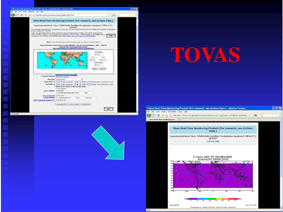
7 TOVAS
8 Reliable Flexible Low-cost System Description Visualization and Analysis Server Receive Parameters from Interface CGI Receive Parameters from Web Client Compose GrADS Script GrADS Environment Execute Generate GrADS Plot/ASCII Script Output Output to Web Browser Output to Web Client Data: Binary or GDS GrADS: The Grid Analysis and Display System (COLA)

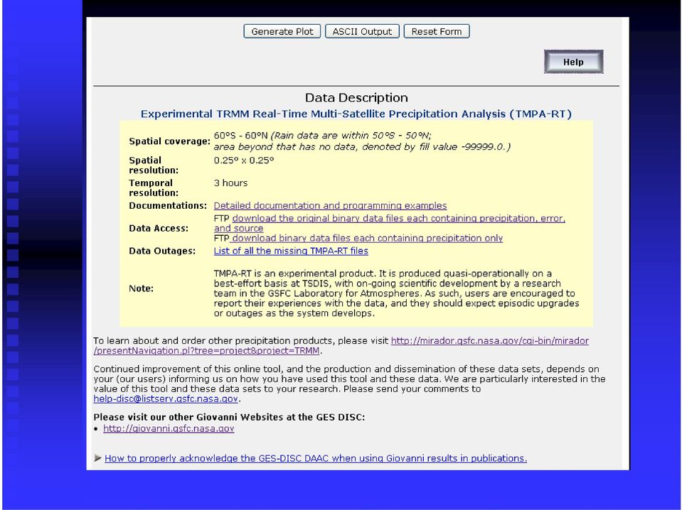
9 Products in TOVAS Near-real-timereal Rainfall Archives Ground Observation Archives Other Ancillary Products

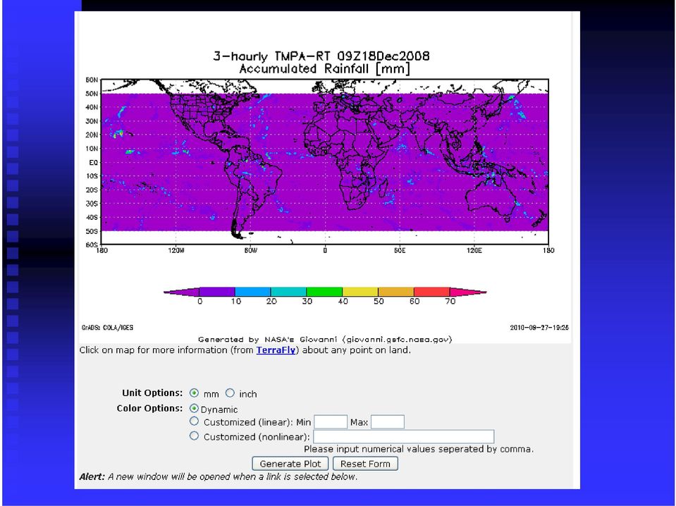
10 Near-real-time 3-Hourly combined (3B42RT) 3-Hourly microwave (3B40RT) Hourly IR (3B41RT) Daily (derived from 3B42RT)
 Daily (derived from")
11 Rainfall Archives 3-Hourly y( (3B42) Daily y( (derived from 3B42) 10-day y( (derived from 3B42) Monthly (3B43, 3A12, 3A25, GPCP, etc.)
 Monthly (3B43, 3A12, 3A25,")
12 Ground Observation Archives Willmott ( , 0.5 deg) GPCC (1986 present, 1 deg)
 GPCC (1986")
13 Others: Monthly Global Precipitation (GPCP) Prototype Interactive Inter-comparison of Rainfall Products Monthly Rainfall (3B43 V6) Anomaly Inter-Comparison of Rainfall Climatology

14 TRMM Web Interface Overview

15 TOVAS Landing Page: /Gi i/t / New

16 Two types of GUIs

17
18
19

20 Accessing new interfaces: New

21
22
23
24
25
26 TOVAS Functions and Examples
27 TOVAS Functions: Animation Lat-Lon Area Plot, Time-averaged Lat-Lon Lon Plot, Difference Map Latitude-Time Hovmöller Plot Longitude-Time Hovmöller Plot Correlation Plot Comparison Plot Cross-Map Plot (Latitude-Height) Cross-Map Plot (Longitude-Height) Cross-Map Plot (Time-Height) Scatter Plot Scatter Plot, Time-averaged Time Series, Area-averaged Time Series Difference Time Series, Area Statistics
28 Other Features: Climatology l Anomaly and normalized anomaly Fine tune graphic output Output in other formats (e.g., NetCDF) Google Earth hkmzfil file output Application examples with real events FAQ and documentation Help desk
29 2D Lat-Lon Plots (Record breaking rainfall in the Mid- Atlantic Region in 2003) Atlantic Region in 2003)
30 2D Plots (The contribution of Isabel in 2003) Isabel
31 Time Series Plots Floyd Alex, Charley, Gaston Isabel Mid- Atlantic Region
32 Hovmoller Diagram (Mid-Atlantic Region) Multiple Tropical Storms Isabel Floyd
33 Anomaly (Positive anomaly due to Isabel in Sept., 2003)
34 Scatter Plot (Error vs Rain Rate, revealing biases)
35 ASCII data output for further analysis (e.g. MS. Excel)
36 Prototype Interactive Inter-comparison of Rainfall Products
37
38
39 Other Ancillary Tools Hurricane Data Analysis Tool (HDAT) Other Giovanni Tools
40 Hurricane Data Analysis Tool: /HDAT The global merged IR product, also known as, the NCEP/CPC 4km Global (60ºN - 60ºS) IR Dataset, is one of TRMM ancillary datasets. 4 km IR Global (60ºN - 60ºS) 30 minutes Since Feb., 2000
41 Basic Functions and Features: Selection of area of interest Single image or multiple l images (animation) Allow time skipping (1 hr., 2 hr., etc.) Allow different image sizes False color Fine tune graphic output
42 HDAT Landing Page
43 HDAT Landing Page (Cont.):
44 HDAT Landing Page (Cont.):
45 HDAT Landing Page (Cont.):
46 Examples: Category 2 cyclone Catarina Landfall
47 AF Flight-447: Satellite Observation of Mesoscale Convective g System Development on 1 June, 2009
48 Dust Strom (near Iraq and Saudi Arabia border)
49 Dust Storm (cont.)
50 TOVAS and HDAT Flooding in Pakistan due to higher-than-normal monsoon rainfall between Jul Aug. 2010
51
52
53 Other Giovanni Tools: i / i i Giovanni: GES-DISC (Goddard Earth Sciences Data and Information Services Center) Interactive Online Visualization ANd analysis Infrastructure
54
55 Cloud Water in g/m3 Cloud Ice in Precipitation Ice (scaled by 100) g/m3 (scaled in g/m3 3( (scaled by 100) by 100)
56 Future Plans for TOVAS: Add more functions IPWG: a proposal p for adding IPWG validation algorithms is pending Add TRMM Level-2 orbital ldata (a prototype to extract 2A12 and 2A25 profiles is ready for YOTC) Add multi-sensor data (e.g., CloudSat)
57 Other TRMM data and services at GES DISC Mirador Other data accessing methods
58 TRMM Data Archive at GES DISC
59 Data Volumes (as of Sept. 22, 2010) Standard products (L-1, L-2, L-3, orbital, gridded): ~20.3 TB (772,553 files) Ancillary data: ~1.9 TB (93,051 files) Ground based instruments: ~4.5 TB (1,853,484) Subsets: ~3.1 TB (2,995,019) File Total: 5,714,107 Total size: ~29.7 TB
60 Mirador Basic Features: Search features: Keyword/event search, projects, science focus areas Spatial subsetting (limited products) Format conversion (e.g., NetCDF)
61 Other Data Access Methods: Giovanni TOVAS (TRMM Online Visualization and Analysis System) GrADS Data Server (GDS) (subsetting and analysis services over the Internet) OPeNDAP (accessed by IDL, GrADS) The Open Geospatial Consortium (OGC) Web Map Server (WMS) Google Earth
62 Demos and Hands-on Exercises
63 Generate a lat-lon map Generate a time series and its ASCII data New interface and data download options
64 URLs: TOVAS: nasa HDAT: Mirador: Giovanni: gov/giovanni GES DISC: Contact:
65 Thank You!
TRMM and Other Global Precipitation Products and Data Services at NASA GES DISC. Zhong Liu George Mason University and NASA GES DISC
 TRMM and Other Global Precipitation Products and Data Services at NASA GES DISC Zhong Liu George Mason University and NASA GES DISC Outline Introduction of data and services at GES DISC TRMM and other
Satellite Products and Dissemination: Visualization and Data Access
 Satellite Products and Dissemination: Visualization and Data Access Gregory Leptoukh GES DISC, NASA GSFC Dana Ostrenga GES DISC, NASA GSFC Introduction The Goddard Earth Sciences Data and Information Services
Asynchronous Data Mining Tools at the GES-DISC
 Asynchronous Data Mining Tools at the GES-DISC Long B. Pham, Stephen W. Berrick, Christopher S. Lynnes and Eunice K. Eng NASA Goddard Space Flight Center Distributed Active Archive Center Introduction
Giovanni: A System for Rapid Access, Visualization and Analysis of Earth Science Data Online
 Giovanni: A System for Rapid Access, Visualization and Analysis of Earth Science Data Online Suhung Shen *, H. Rui, Z. Liu, T Zhu, L. Lu, S. Berrick, G. Leptoukh, W. Teng, J. Acker, J. Johnson, S. P. Ahmad,
Tropical Rainfall Measuring Mission (TRMM) Precipitation Data and Services for
 Precipitation Data and Services for") 1 2 Tropical Rainfall Measuring Mission (TRMM) Precipitation Data and Services for Research and Applications 3 4 5 6 7 8 9 10 Zhong Liu 1, Dana Ostrenga 2, William Teng 3, and Steven Kempler NASA Goddard
1 2 Tropical Rainfall Measuring Mission (TRMM) Precipitation Data and Services for Research and Applications 3 4 5 6 7 8 9 10 Zhong Liu 1, Dana Ostrenga 2, William Teng 3, and Steven Kempler NASA Goddard
Web-based spatio-temporal visualization and analysis of the Siberian Earth System Science Cluster (SIB-ESS-C)
") Web-based spatio-temporal visualization and analysis of the Siberian Earth System Science Cluster (SIB-ESS-C) Roman Gerlach Supervisor: Prof. C. Schmullius (Dept. of Geography, Friedrich-Schiller-University
Web-based spatio-temporal visualization and analysis of the Siberian Earth System Science Cluster (SIB-ESS-C) Roman Gerlach Supervisor: Prof. C. Schmullius (Dept. of Geography, Friedrich-Schiller-University
Satellite'&'NASA'Data'Intro'
 Satellite'&'NASA'Data'Intro' Research'vs.'Opera8ons' NASA':'Research'satellites' ' ' NOAA/DoD:'Opera8onal'Satellites' NOAA'Polar'Program:'NOAA>16,17,18,19,NPP' Geosta8onary:'GOES>east,'GOES>West' DMSP'series:'SSM/I,'SSMIS'
New Precipitation products (GPM, GCOM-W) and more
 and more") New Precipitation products (GPM, GCOM-W) and more Misako KACHI Earth Observation Research Center (EORC) Japan Aerospace Exploration Agency (JAXA) 19 Nov. 2014, IPWG Training Course 2 Satellite Product
New Precipitation products (GPM, GCOM-W) and more Misako KACHI Earth Observation Research Center (EORC) Japan Aerospace Exploration Agency (JAXA) 19 Nov. 2014, IPWG Training Course 2 Satellite Product
The NASA NEESPI Data Portal to Support Studies of Climate and Environmental Changes in Non-boreal Europe
 The NASA NEESPI Data Portal to Support Studies of Climate and Environmental Changes in Non-boreal Europe Suhung Shen NASA Goddard Space Flight Center/George Mason University Gregory Leptoukh, Tatiana Loboda,
Norwegian Satellite Earth Observation Database for Marine and Polar Research http://normap.nersc.no USE CASES
 Norwegian Satellite Earth Observation Database for Marine and Polar Research http://normap.nersc.no USE CASES The NORMAP Project team has prepared this document to present functionality of the NORMAP portal.
EXPLORING NASA AND ESA ATMOSPHERIC DATA USING GIOVANNI, THE ONLINE VISUALIZATION AND ANALYSIS TOOL
 EXPLORING NASA AND ESA ATMOSPHERIC DATA USING GIOVANNI, THE ONLINE VISUALIZATION AND ANALYSIS TOOL Gregory Leptoukh (1), Steve Cox (2), John Farley (2), Arun Gopalan (2), Jianping Mao (2), Stephen Berrick
Development of an Integrated Data Product for Hawaii Climate
 Development of an Integrated Data Product for Hawaii Climate Jan Hafner, Shang-Ping Xie (PI)(IPRC/SOEST U. of Hawaii) Yi-Leng Chen (Co-I) (Meteorology Dept. Univ. of Hawaii) contribution Georgette Holmes
A Microwave Retrieval Algorithm of Above-Cloud Electric Fields
 A Microwave Retrieval Algorithm of Above-Cloud Electric Fields Michael J. Peterson The University of Utah Chuntao Liu Texas A & M University Corpus Christi Douglas Mach Global Hydrology and Climate Center
Outline. Case Study over Vale do Paraiba 11 February 2012. Comparison of different rain rate retrievals for heavy. Future Work
 Outline Short description of the algorithms for rain rate retrievals from passive microwave radiometers on board low-orbiting satellites (i.e., SSMI/S) Case Study over Vale do Paraiba 11 February 2012
George Mason University (GMU)
") George Mason University (GMU) Center for Spatial Information Science and Systems Organization (CSISS) 4400 University Drive, MSN 6E1 George Mason University Fairfax, VA 22030, USA Telephone: +1 703 993
George Mason University (GMU) Center for Spatial Information Science and Systems Organization (CSISS) 4400 University Drive, MSN 6E1 George Mason University Fairfax, VA 22030, USA Telephone: +1 703 993
Tropical Cloud Population
 Tropical Cloud Population Before Satellites Visual Observation View from and aircraft flying over the South China Sea Radiosonde Data Hot tower hypothesis Riehl & Malkus 1958 Satellite Observations Post
Chapter 2 False Alarm in Satellite Precipitation Data
 Chapter 2 False Alarm in Satellite Precipitation Data Evaluation of satellite precipitation algorithms is essential for future algorithm development. This is why many previous studies are devoted to the
Structure? Integrated Climate Data Center How to use the ICDC? Tools? Data Formats? User
 Integrated Climate Data Center? Data Formats?? Tools???? visits Structure???? User Contents Which Data Formats do we offer? What is the Structure of our data center? Which Tools do we provide? Our Aims
Thomas Fiolleau Rémy Roca Frederico Carlos Angelis Nicolas Viltard. www.satmos.meteo.fr
 Comparison of tropical convective systems life cycle characteristics from geostationary and TRMM observations for the West African, Indian and South American regions Thomas Fiolleau Rémy Roca Frederico
NASA s Big Data Challenges in Climate Science
 NASA s Big Data Challenges in Climate Science Tsengdar Lee, Ph.D. High-end Computing Program Manager NASA Headquarters Presented at IEEE Big Data 2014 Workshop October 29, 2014 1 2 7-km GEOS-5 Nature Run
HYCOM Meeting. Tallahassee, FL
 HYCOM Data Service An overview of the current status and new developments in Data management, software and hardware Ashwanth Srinivasan & Jon Callahan COAPS FSU & PMEL HYCOM Meeting Nov 7-9, 7 2006 Tallahassee,
Precipitation Remote Sensing
 Precipitation Remote Sensing Huade Guan Prepared for Remote Sensing class Earth & Environmental Science University of Texas at San Antonio November 14, 2005 Outline Background Remote sensing technique
NOMADS. Jordan Alpert, Jun Wang NCEP/NWS. Jordan C. Alpert jordan.alpert@noaa.gov. where the nation s climate and weather services begin
 An Application for High Availability NOMADS Jordan Alpert, Jun Wang NCEP/NWS Jordan C. Alpert jordan.alpert@noaa.gov DMIT Workshop, Silver Spring, MD 8/13-14//2009 where the nation s climate and weather
Description of Scatterometer Data Products
 Scatterometer Data:// Description of Scatterometer Data Products QuikScat is no longer operational - last data recorded: 2009-Nov-23 REMSS QuikScat data set currently ends on 2009-11-19; data after that
PART 1. Representations of atmospheric phenomena
 PART 1 Representations of atmospheric phenomena Atmospheric data meet all of the criteria for big data : they are large (high volume), generated or captured frequently (high velocity), and represent a
Information Technology Implementation for a Distributed Data System Serving Earth Scientists: Seasonal to Interannual ESIP
 Information Technology Implementation for a Distributed Data System Serving Earth Scientists: Seasonal to Interannual ESIP Menas Kafatos CEOSR/CSI, George Mason University, Fairfax, VA mkafatos@gmu.edu
Parameterization of Cumulus Convective Cloud Systems in Mesoscale Forecast Models
 DISTRIBUTION STATEMENT A. Approved for public release; distribution is unlimited. Parameterization of Cumulus Convective Cloud Systems in Mesoscale Forecast Models Yefim L. Kogan Cooperative Institute
IMPACTS OF IN SITU AND ADDITIONAL SATELLITE DATA ON THE ACCURACY OF A SEA-SURFACE TEMPERATURE ANALYSIS FOR CLIMATE
 INTERNATIONAL JOURNAL OF CLIMATOLOGY Int. J. Climatol. 25: 857 864 (25) Published online in Wiley InterScience (www.interscience.wiley.com). DOI:.2/joc.68 IMPACTS OF IN SITU AND ADDITIONAL SATELLITE DATA
Huai-Min Zhang & NOAAGlobalTemp Team
 Improving Global Observations for Climate Change Monitoring using Global Surface Temperature (& beyond) Huai-Min Zhang & NOAAGlobalTemp Team NOAA National Centers for Environmental Information (NCEI) [formerly:
Visualization of and Access to CloudSat Vertical Data through Google Earth. NASA Goddard Space Flight Center, Code 610.2, Greenbelt, MD, 20771, USA
 Visualization of and Access to CloudSat Vertical Data through Google Earth Aijun Chen 1,2, Gregory Leptoukh 2, Liping Di 1, Steven Kempler 2 and Christopher Lynnes 2 1 George Mason University, 6301 Ivy
Open Source Visualisation with ADAGUC Web Map Services
 Open Source Visualisation with ADAGUC Web Map Services Maarten Plieger Ernst de Vreede John van de Vegte, Wim Som de Cerff, Raymond Sluiter, Ian van der Neut, Jan Willem Noteboom 1 ADAGUC project Cooperative
Current Order Tool Experiences Complaints
 Current Order Tool Experiences Complaints Log in unadvertised case sensitivity for email address that is used as login id CERES Dataset Info pages are too crowded!! On the Data Products Catalog page, remove
NASA's Strategy and Activities in Server Side Analytics
 NASA's Strategy and Activities in Server Side Analytics Tsengdar Lee, Ph.D. High-end Computing Program Manager NASA Headquarters Presented at the ESGF/UVCDAT Conference Lawrence Livermore National Laboratory
CEOS Water Portal Status Update
 CEOS Water Portal Status Update Satoko Horiyama MIURA / Atsushi KAWAI JAXA/Mission Operations System Office WGISS-31 Introduction CEOS Water Portal is ; A web based portal system evolved from Distributed
MSG Cloud Physical Properties retrieval and visualization
 MSG Cloud Physical Properties retrieval and visualization Jan Fokke Meirink Maarten Plieger John van de Vegte The MSG-CPP Project Goal: Provide an operational service for all products that are derived
http://www.isac.cnr.it/~ipwg/
 The CGMS International Precipitation Working Group: Experience and Perspectives Vincenzo Levizzani CNR-ISAC, Bologna, Italy and Arnold Gruber NOAA/NESDIS & Univ. Maryland, College Park, MD, USA http://www.isac.cnr.it/~ipwg/
IDL. Get the answers you need from your data. IDL
 Get the answers you need from your data. IDL is the preferred computing environment for understanding complex data through interactive visualization and analysis. IDL Powerful visualization. Interactive
Welcome to NASA Applied Remote Sensing Training (ARSET) Webinar Series
 Webinar Series") Welcome to NASA Applied Remote Sensing Training (ARSET) Webinar Series Introduction to Remote Sensing Data for Water Resources Management Course Dates: October 17, 24, 31 November 7, 14 Time: 8-9 a.m.
Welcome to NASA Applied Remote Sensing Training (ARSET) Webinar Series Introduction to Remote Sensing Data for Water Resources Management Course Dates: October 17, 24, 31 November 7, 14 Time: 8-9 a.m.
Severe Weather & Hazards Related Research at CREST
 Severe Weather & Hazards Related Research at CREST (Lead Scientists) Z. Johnny Luo, Nir Krakauer, Shayesteh Mahani, Fabrice Papa, Marouane Temimi and Brian Vant Hull (NOAA Collaborators) Arnold Gruber,
THE STRATEGIC PLAN OF THE HYDROMETEOROLOGICAL PREDICTION CENTER
 THE STRATEGIC PLAN OF THE HYDROMETEOROLOGICAL PREDICTION CENTER FISCAL YEARS 2012 2016 INTRODUCTION Over the next ten years, the National Weather Service (NWS) of the National Oceanic and Atmospheric Administration
SCIENCE AND TECHNOLOGY INFUSION CLIMATE BULLETIN
 Science and Technology Infusion Climate Bulletin NOAA s National Weather Service 37 th NOAA Annual Climate Diagnostics and Prediction Workshop Fort Collins, CO, 22-25 October 2012 Web-Based Reanalysis
GOSIC NEXRAD NIDIS NOMADS
 NOAA National Climatic Data Center GOSIC NEXRAD NIDIS NOMADS Christina Lief NOAA/NESDIS/NCDC GOSIC Program Manager NOAA/NESDIS/NCDC Asheville, NC 28801 GEOSS AIP Phase 2 Workshop September 25-26, 2008
J9.6 GIS TOOLS FOR VISUALIZATION AND ANALYSIS OF NEXRAD RADAR (WSR-88D) ARCHIVED DATA AT THE NATIONAL CLIMATIC DATA CENTER
 ARCHIVED DATA AT THE NATIONAL CLIMATIC DATA CENTER") J9.6 GIS TOOLS FOR VISUALIZATION AND ANALYSIS OF RADAR (WSR-88D) ARCHIVED DATA AT THE NATIONAL CLIMATIC DATA CENTER Steve Ansari * STG Incorporated, Asheville, North Carolina Stephen Del Greco NOAA National
J9.6 GIS TOOLS FOR VISUALIZATION AND ANALYSIS OF RADAR (WSR-88D) ARCHIVED DATA AT THE NATIONAL CLIMATIC DATA CENTER Steve Ansari * STG Incorporated, Asheville, North Carolina Stephen Del Greco NOAA National
A TRMM-Based Tropical Cyclone Cloud and Precipitation Feature Database
 JUNE 011 J I A N G E T A L. 5 A TRMM-Based Tropical Cyclone Cloud and Precipitation Feature Database HAIYAN JIANG Department of Earth and Environment, Florida International University, Miami, Florida CHUNTAO
2. VIIRS SDR Tuple and 2Dhistogram MIIC Server-side Filtering. 3. L2 CERES SSF OPeNDAP dds structure (dim_alias and fixed_dim)
") MIIC Server-side Filtering Outline 1. DEMO Web User Interface (leftover from last meeting) 2. VIIRS SDR Tuple and 2Dhistogram MIIC Server-side Filtering 3. L2 CERES SSF OPeNDAP dds structure (dim_alias
MIIC Server-side Filtering Outline 1. DEMO Web User Interface (leftover from last meeting) 2. VIIRS SDR Tuple and 2Dhistogram MIIC Server-side Filtering 3. L2 CERES SSF OPeNDAP dds structure (dim_alias
GCMs with Implicit and Explicit cloudrain processes for simulation of extreme precipitation frequency
 GCMs with Implicit and Explicit cloudrain processes for simulation of extreme precipitation frequency In Sik Kang Seoul National University Young Min Yang (UH) and Wei Kuo Tao (GSFC) Content 1. Conventional
The Arctic Observing Network and its Data Management Challenges Florence Fetterer (NSIDC/CIRES/CU), James A. Moore (NCAR/EOL), and the CADIS team
, James A. Moore (NCAR/EOL), and the CADIS team") The Arctic Observing Network and its Data Management Challenges Florence Fetterer (NSIDC/CIRES/CU), James A. Moore (NCAR/EOL), and the CADIS team Photo courtesy Andrew Mahoney NSF Vision What is AON? a
The Arctic Observing Network and its Data Management Challenges Florence Fetterer (NSIDC/CIRES/CU), James A. Moore (NCAR/EOL), and the CADIS team Photo courtesy Andrew Mahoney NSF Vision What is AON? a
Latin American and Caribbean Flood and Drought Monitor Tutorial Last Updated: November 2014
 Latin American and Caribbean Flood and Drought Monitor Tutorial Last Updated: November 2014 Introduction: This tutorial examines the main features of the Latin American and Caribbean Flood and Drought
Daily High-resolution Blended Analyses for Sea Surface Temperature
 Daily High-resolution Blended Analyses for Sea Surface Temperature by Richard W. Reynolds 1, Thomas M. Smith 2, Chunying Liu 1, Dudley B. Chelton 3, Kenneth S. Casey 4, and Michael G. Schlax 3 1 NOAA National
HYCOM Data Management -- opportunities & planning --
 HYCOM Data Management -- opportunities & planning -- Steve Hankin (NOAA/PMEL) Ashwanth Srinivasan, (RSMAS) Peter Cornillon, OPeNDAP PI (URI) Mike Clancy, US GODAE Server (FNMOC) Jon Callahan, Kevin O Brien
A Project to Create Bias-Corrected Marine Climate Observations from ICOADS
 A Project to Create Bias-Corrected Marine Climate Observations from ICOADS Shawn R. Smith 1, Mark A. Bourassa 1, Scott Woodruff 2, Steve Worley 3, Elizabeth Kent 4, Simon Josey 4, Nick Rayner 5, and Richard
TRMM and Other Data Precipitation Data Set Documentation. George J. Huffman (1) David T. Bolvin (1,2)
 David T. Bolvin (1,2)") TRMM and Other Data Precipitation Data Set Documentation George J. Huffman (1) David T. Bolvin (1,2) (1) Mesoscale Atmospheric Processes Laboratory, NASA Goddard Space Flight Center (2) Science Systems
TRMM and Other Data Precipitation Data Set Documentation George J. Huffman (1) David T. Bolvin (1,2) (1) Mesoscale Atmospheric Processes Laboratory, NASA Goddard Space Flight Center (2) Science Systems
Titelmasterformat durch Klicken. bearbeiten
 Evaluation of a Fully Coupled Atmospheric Hydrological Modeling System for the Sissili Watershed in the West African Sudanian Savannah Titelmasterformat durch Klicken June, 11, 2014 1 st European Fully
Passive and Active Microwave Remote Sensing of Cold-Cloud Precipitation : Wakasa Bay Field Campaign 2003
 Passive and Active Microwave Remote Sensing of Cold-Cloud Precipitation : Wakasa Bay Field Campaign 3 Benjamin T. Johnson,, Gail Skofronick-Jackson 3, Jim Wang 3, Grant Petty jbenjam@neptune.gsfc.nasa.gov
Medspiration system & operations summary, legacy and future
 Medspiration system & operations summary, legacy and future JF Piollé, Ian Robinson, Pierre Leborgne, Dave Poulter et al. Medspiration legacy : data products Direct observations (L2P) Gap free high resolution
1. Overview and Status Update (Satoko) : 10min. 2. Demonstration (Yoshi) : 20min. 3. New Architecture (Yoshi): 15min. 4. Q&A, Discussion (All) : 15min
 : 10min. 2. Demonstration (Yoshi) : 20min. 3. New Architecture (Yoshi): 15min. 4. Q&A, Discussion (All) : 15min") 1. Overview and Status Update (Satoko) : 10min 2. Demonstration (Yoshi) : 20min 3. New Architecture (Yoshi): 15min 4. Q&A, Discussion (All) : 15min 1 CEOS Water Portal Overview and Status Update WGISS-37
1. Overview and Status Update (Satoko) : 10min 2. Demonstration (Yoshi) : 20min 3. New Architecture (Yoshi): 15min 4. Q&A, Discussion (All) : 15min 1 CEOS Water Portal Overview and Status Update WGISS-37
DataTube: web services voor data
 DataTube: web services voor data Gerben de Boer Onno van de Akker Gerrit Hendriksen Deltares, Matroos Deltares, FEWS Deltares, NHI FEWS & Matroos: database > viewers VIEWER client 3 rd party viewer Matroos
Clouds and the Energy Cycle
 August 1999 NF-207 The Earth Science Enterprise Series These articles discuss Earth's many dynamic processes and their interactions Clouds and the Energy Cycle he study of clouds, where they occur, and
Overview: The relative importance of intense vs. moderate convection to rapid intensification
 Overview: The relative importance of intense vs. moderate convection to rapid intensification Edward Zipser Department of Atmospheric Sciences University of Utah, Salt Lake City, UT, USA ed.zipser@utah.edu
Validation of SEVIRI cloud-top height retrievals from A-Train data
 Validation of SEVIRI cloud-top height retrievals from A-Train data Chu-Yong Chung, Pete N Francis, and Roger Saunders Contents Introduction MO GeoCloud AVAC-S Long-term monitoring Comparison with OCA Summary
How Raising TRMM s Altitude to 400km Impacts PR Operation. June 1, 2001 NASDA EORC with support of PR team
 How Raising TRMM s Altitude to 400km Impacts PR Operation June 1, 2001 NASDA EORC with support of PR team 1. Background and Introduction TRMM is planned to make a controlled reentry at the end of its life
Obtaining and Processing MODIS Data
 Obtaining and Processing MODIS Data MODIS is an extensive program using sensors on two satellites that each provide complete daily coverage of the earth. The data have a variety of resolutions; spectral,
 Integrated Data Viewer (IDV) a visualization framework Yuan Ho Unidata Program Center Boulder, CO Presentation Outline Integrated Data Viewer (IDV) overview The IDV features IDV examples and customized
GLOBAL CLIMATE MONITOR
 FP7 INCO- 2011 7 INCO- LAB project 294947 https://swanproject.arizona.edu/ GLOBAL CLIMATE MONITOR Natalia Limones (natalialr@us.es) José I. Alvarez (jose_afra@yahoo.es) Juan M. Camarillo (jmcamarillo@us.es)
Using Message Brokering and Data Mediation to use Distributed Data Networks of Earth Science Data to Enhance Global Maritime Situational Awareness.
 Using Message Brokering and Data Mediation to use Distributed Data Networks of Earth Science Data to Enhance Global Maritime Situational Awareness. Conor Delaney, Alfredo Alessandrini & Harm Greidanus
Environmental Data Services for Delaware:
 Environmental Data Services for Delaware: Serving Emergency Responders, Planners, and Researchers Network Delaware Day November 6, 2013 Overview Operational Data Services More than just research DEOS and
Hurricanes. Characteristics of a Hurricane
 Hurricanes Readings: A&B Ch. 12 Topics 1. Characteristics 2. Location 3. Structure 4. Development a. Tropical Disturbance b. Tropical Depression c. Tropical Storm d. Hurricane e. Influences f. Path g.
Investigation of the Use of Satellite Rainfall Observations in Improving Risk Assessment for Wheat Fusarium Head Blight
 Investigation of the Use of Satellite Rainfall Observations in Improving Risk Assessment for Wheat Fusarium Head Blight June 29, 2007 Candidate Solution Constituents a. Title: Investigation of the Use
Comparison of Cloud and Radiation Variability Reported by Surface Observers, ISCCP, and ERBS
 Comparison of Cloud and Radiation Variability Reported by Surface Observers, ISCCP, and ERBS Joel Norris (SIO/UCSD) Cloud Assessment Workshop April 5, 2005 Outline brief satellite data description upper-level
Improving Dynamical Prediction of Seasonal Mean Monsoon & Extended Range Prediction of Active-Break Spells
 Annual Cycle Improving Dynamical Prediction of Seasonal Mean Monsoon & Extended Range Prediction of Active-Break Spells M Rajeevan National Atmospheric Research Laboratory, Gadanki Inputs: Dr Suryachandra
Creating user-friendly tools for data analysis and visualization in K-12 classrooms: A Fortran dinosaur meets Generation Y
 Creating user-friendly tools for data analysis and visualization in K-12 classrooms: A Fortran dinosaur meets Generation Y L. H. Chambers 1, S. Chaudhury 2, M. T. Page 2, A. J. Lankey 3, J. Doughty 4,
Matsu: An Elastic Cloud Connected to a SensorWeb for Disaster. (Session 12F Working Group: Cloud Computing for Spacecraft Operations)
") Matsu: An Elastic Cloud Connected to a SensorWeb for Disaster Response (Session 12F Working Group: Cloud Computing for Spacecraft Operations) Daniel Mandl - NASA/GSFC 3/2/11 1 SensorWeb High Level Architecture
Matsu: An Elastic Cloud Connected to a SensorWeb for Disaster Response (Session 12F Working Group: Cloud Computing for Spacecraft Operations) Daniel Mandl - NASA/GSFC 3/2/11 1 SensorWeb High Level Architecture
Joint Polar Satellite System (JPSS)
") Joint Polar Satellite System (JPSS) John Furgerson, User Liaison Joint Polar Satellite System National Environmental Satellite, Data, and Information Service National Oceanic and Atmospheric Administration
Joint Polar Satellite System (JPSS) John Furgerson, User Liaison Joint Polar Satellite System National Environmental Satellite, Data, and Information Service National Oceanic and Atmospheric Administration
THE DEVELOPMENT OF A PROTOTYPE GEOSPATIAL WEB SERVICE SYSTEM FOR REMOTE SENSING DATA
 THE DEVELOPMENT OF A PROTOTYPE GEOSPATIAL WEB SERVICE SYSTEM FOR REMOTE SENSING DATA Meixia Deng a, *, Peisheng Zhao a, Yang Liu a, Aijun Chen a Liping Di a a George Mason University, Laboratory for Advanced
MyOcean Copernicus Marine Service Architecture and data access Experience
 MyOcean Copernicus Marine Service Architecture and data access Experience Sophie Besnard CLS, Toulouse, France February 2015 MyOcean Story MyOcean Challenge & Success MyOcean Service MyOcean System MyOcean
Data and data product visualization in EMODNET Chemistry
 Data and data product visualization in EMODNET Chemistry Alexander Barth (1), Giorgio Santinelli (2), Gerrit Hendriksen (2), Jean-Marie Beckers (1) (1) University of Liège (Belgium), (2) Deltares (Netherlands)
André Karpištšenko, Co-Founder & Chief Scientist, Marinexplore Strata, 2014.02.11
 marineos André Karpištšenko, Co-Founder & Chief Scientist, Marinexplore Strata, 2014.02.11 The Ocean's Big Data Platform marineos: a platform for organizing, analyzing and distributing machine data marineos
Nevada NSF EPSCoR Track 1 Data Management Plan
 Nevada NSF EPSCoR Track 1 Data Management Plan August 1, 2011 INTRODUCTION Our data management plan is driven by the overall project goals and aims to ensure that the following are achieved: Assure that
Jozef Matula. Visualisation Team Leader IBL Software Engineering. 13 th ECMWF MetOps Workshop, 31 th Oct - 4 th Nov 2011, Reading, United Kingdom
 Visual Weather web services Jozef Matula Visualisation Team Leader IBL Software Engineering Outline Visual Weather in a nutshell. Path from Visual Weather (as meteorological workstation) to Web Server
DEVELOPING WEB-BASED MAPPING SERVICES FOR PUBLIC HEALTH APPLICATIONS
 DEVELOPING WEB-BASED MAPPING SERVICES FOR PUBLIC HEALTH APPLICATIONS Amelia M. Budge a *, Karl K. Benedict a, and William Hudspeth a a EDAC, University of New Mexico, Albuquerque, NM 87131-0001, USA-(abudge,
SPARC Data Center. www.sparc.sunysb.edu. Peter Love Marvin Geller Institute for Terrestrial and Planetary Atmospheres Stony Brook University
 SPARC Data Center www.sparc.sunysb.edu Peter Love Marvin Geller Institute for Terrestrial and Planetary Atmospheres Stony Brook University SPARC Data Centre Overview Exists to facilitate data exchange
ADAGUC & PyTROLL. Maarten Plieger Ernst de Vreede. Application of polar orbiter products in weather forecasting Using open source tools and standards
 Application of polar orbiter products in weather forecasting Using open source tools and standards ADAGUC & PyTROLL Maarten Plieger Ernst de Vreede Royal Netherlands Meteorological Institute (KNMI) R&D
The distribution of marine OpenData via distributed data networks and Web APIs. The example of ERDDAP, the message broker and data mediator from NOAA
 The distribution of marine OpenData via distributed data networks and Web APIs. The example of ERDDAP, the message broker and data mediator from NOAA Dr. Conor Delaney 9 April 2014 GeoMaritime, London
JOURNAL OF GEOPHYSICAL RESEARCH, VOL. 115, XXXXXX, doi:10.1029/2008jd011189, 2010
 Click Here for Full Article JOURNAL OF GEOPHYSICAL RESEARCH, VOL. 115,, doi:10.1029/2008jd011189, 2010 2 Comment on Variations of tropical upper 3 tropospheric clouds with sea surface temperature and 4
e-infrastructure of DIAS
 e-infrastructure of DIAS Toshihiro Nemoto 1 Masaru Kitsuregawa 2 1 Earth Observation Data Integration and Fusion Initiative, The Univ. of Tokyo 2 Director General of National Institute of Informatics(NII)
Coherent evaluation of aerosol data products from multiple satellite sensors Charles Ichoku, Maksym Petrenko, and Greg Leptoukh
 Coherent evaluation of aerosol data products from multiple satellite sensors Charles Ichoku, Maksym Petrenko, and Greg Leptoukh Image: Terra-MODIS true color RGB of 01-Apr-2002 (courtesy: NASA EarthObservatory
CCAR Near Real Time and Historical Altimeter Data Server
 CCAR Near Real Time and Historical Altimeter Data Server http://eddy.colorado.edu/ccar/data_viewer/index Bob Leben March 2015 GCOOS BOD Meeting CCAR Near Real Time Altimeter Data System! In late 1995,
An A-Train Water Vapor Thematic Climate Data Record Using Cloud Classification
 An A-Train Water Vapor Thematic Climate Data Record Using Cloud Classification Eric J. Fetzer, Qing Yue, Alexandre Guillaume, Van T. Dang, Calvin Liang, Brian H. Kahn, Brian D. Wilson, Bjorn H. Lambrigtsen
Keystone Image Management System
 Image management solutions for satellite and airborne sensors Overview The Keystone Image Management System offers solutions that archive, catalogue, process and deliver digital images from a vast number
Reprojecting MODIS Images
 Reprojecting MODIS Images Why Reprojection? Reasons why reprojection is desirable: 1. Removes Bowtie Artifacts 2. Allows geographic overlays (e.g. coastline, city locations) 3. Makes pretty pictures for
GEOCOMPUTATIONS AND RELATED WEB SERVICES
 GEOCOMPUTATIONS AND RELATED WEB SERVICES J. A. Rod Blais Dept. of Geomatics Engineering Pacific Institute for the Mathematical Sciences University of Calgary, Calgary, Alberta T2N 1N4 blais@ucalgary.ca
A Web Service based U.S. Cropland Visualization, Dissemination and Querying System
 A Web Service based U.S. Cropland Visualization, Dissemination and Querying System Rick Mueller, Zhengwei Yang, and Dave Johnson USDA/National Agricultural Statistics Service Weiguo Han and Liping Di GMU/Center
5.2 GLOBAL DISTRIBUTION OF CONVECTION PENETRATING THE TROPICAL TROPOPAUSE. Chuntao Liu * and Edward J. Zipser University of Utah, Salt Lake City, Utah
 5.2 GLOBAL DISTRIBUTION OF CONVECTION PENETRATING THE TROPICAL TROPOPAUSE Chuntao Liu * and Edward J. Zipser University of Utah, Salt Lake City, Utah 1. INTRODUCTION Tropical cumulonimbus clouds have long
Real-time Global Flood Monitoring and Forecasting using an Enhanced Land Surface Model with Satellite and NWP model based Precipitation
 Real-time Global Flood Monitoring and Forecasting using an Enhanced Land Surface Model with Satellite and NWP model based Precipitation Huan Wu,2, Robert F. Adler, 2, Yudong Tian, 2, George J. Huffman
CLOUD BASED N-DIMENSIONAL WEATHER FORECAST VISUALIZATION TOOL WITH IMAGE ANALYSIS CAPABILITIES
 CLOUD BASED N-DIMENSIONAL WEATHER FORECAST VISUALIZATION TOOL WITH IMAGE ANALYSIS CAPABILITIES M. Laka-Iñurrategi a, I. Alberdi a, K. Alonso b, M. Quartulli a a Vicomteh-IK4, Mikeletegi pasealekua 57,
Temporal variation in snow cover over sea ice in Antarctica using AMSR-E data product
 Temporal variation in snow cover over sea ice in Antarctica using AMSR-E data product Michael J. Lewis Ph.D. Student, Department of Earth and Environmental Science University of Texas at San Antonio ABSTRACT
Model examples Store and provide Challenges WCS and OPeNDAP Recommendations. WCS versus OPeNDAP. Making model results available through the internet.
 Making model results available through the internet. Fedor Baart, Gerben de Boer, Wim de Haas, Gennadiy Donchyts, Marc Philippart, Maarten Plieger September 14, 2011 Introduction Fedor Baart PhD thesis:
Overview of NASA Applied Remote Sensing Training Program on Water Resources and Disaster Management
 Overview of NASA Applied Remote Sensing Training Program on Water Resources and Disaster Management ARSET Applied Remote SEnsing Training A project of NASA Applied Sciences Outline About ARSET ARSET Trainings
Design and Deployment of Specialized Visualizations for Weather-Sensitive Electric Distribution Operations
 Fourth Symposium on Policy and Socio-Economic Research 4.1 Design and Deployment of Specialized Visualizations for Weather-Sensitive Electric Distribution Operations Lloyd A. Treinish IBM, Yorktown Heights,
SARAL ACCESS TO OFF-LINE DATA
 SARAL AltiKa introduction Plot of the SARAL/AltiKa ground track over Africa (Credits: Google). S ARAL/AltiKa is a new mission in cooperation between CNES and ISRO (Indian Space Research Organization),