Quantifying Potential Floodplain Restoration Benefits in the Upper Mississippi River Basin, USA
|
|
|
- Jean Baker
- 8 years ago
- Views:
Transcription
1 Quantifying Potential Floodplain Restoration Benefits in the Upper Mississippi River Basin, USA Michael Schwar, Ph.D. PE (MARS) Eileen Fretz (American Rivers)

2 Mississippi River Commission/USACE

3 Upper Mississippi Watershed Portions of eight states 190,000 mi 2 Floods driven by rainfall and/ or snowmelt Generally low gradient, wide flat floodplains

4 American Rivers UMRB Focus Develop strategies to remove barriers to protecting and restoring natural floodplain function Policy recommendations for developing incentives and removing barriers Technical analysis on floodplain benefits Set the groundwork for implementing projects Increase outreach on alternatives to structural floodplain control

5 Levee Removal/Setback Sediment Trapping Multiple Benefits USGS UMESC University of Illinois Extension

6 Levee Removal/Setback Multiple Benefits Nutrient Transformation USGS WSP 2425 USGS 2003,modified from Goolsby et al. 1999

7 Habitat Levee Removal/Setback Multiple Benefits Illinois State Geological Survey Wisconsin DNR

8 Levee Removal/Setback Focus on flood risk reduction: Provide floodplain volume Floodplain active for more frequent events Number of factors relevant to storage benefits: Volume Location Hydrograph characteristics Elevation/Time when storage is engaged In some cases, improves hydraulics (reduced constriction)

9 Motivation American Rivers was looking for a concept-level method to quantify flood reduction benefits of restoring floodplain volume (removing levees) in Upper Mississippi River Basin Local proponents can determine what are reasonable expectations of level of benefits and/or level of effort necessary to meet expectations

10 Modeling HSPF v. 12 BASINS Existing Data Levee databases USGS topo or LIDAR Hydrography USGS Gage Records

11 HSPF Continuous simulation of hydrologic and water quality processes Uses meteorological input records to generate synthetic watershed output (e.g. streamflow) over extended time periods (e.g. years or decades)
")
12 Modeling Looked at three different watersheds (MRBI focus) Spoon River, IL Middle Minnesota River, MN Cedar River, IA Watersheds identified had existing HSPF models developed and calibrated by others (for TMDLs or other purposes) Did not focus on mainstem Mississippi or Illinois Rivers
 Did not focus on mainstem Mississippi or Illinois")
13 Methodology Run the model, develop baseline hydrographs throughout watershed Add representation of storage areas to model Rerun model, look at hydrograph changes

14 Mean Daily Flow at Janesville

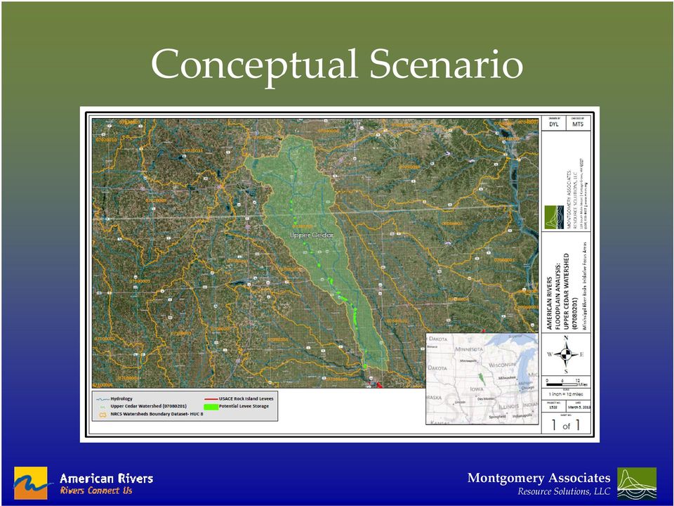
15 Restoration Scenarios Using aerial photography and USGS topos identified 29 potential sites Delineated areas using Arc GIS Assumed levee heights (along Upper Cedar River = 4.5 ft) Compiled potential volume by reach

16 Conceptual Scenario
17 Results For flood study, used annual peak flow analysis Relevant factors Volume storage vs. stream flow Location of storage vs. benefit observed Elevation of restored floodplain

18 Weighted Storage Volume Ratio WSR = Ratio of Drainage Areas (Restored site/site of benefits) x Volume Ratio (Restored floodplain/2-year, 24-hour streamflow volume)

19 Results All Three UMRB Watersheds
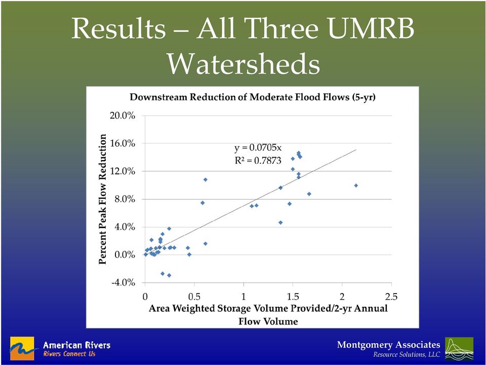
20 Results All Three UMRB Watersheds

21 Results Benefits primarily for small to moderate events (<10 year recurrence), with some exceptions Minimum restored subbasin area ~1-2% to see flood reduction benefits Seem to be generally applicable in investigated watersheds
22 Planning-Level Analysis Calculate the WSR for the project and benefit location Decision tree for benefits based on: Elevation relative to 2-yr floodplain Level of channelization vs. meander belts Percent reduction for moderate (2-10 yr) floods = 7.1 x WSR
23 General Method to Analyze Potential Restoration Benefits Identify continuous model of watershed Formulate restoration goals in terms of Stage/depth Duration Temperature Time of Year Other? Develop a range of conceptual restoration scenarios Revise and run model reflecting scenarios Investigate weighted ratios to explain observed watershed responses to restoration
24 Nutrient Transformation Analysis Example: How much area is experiencing extended inundation and how can restoration increase that area? Area Inundated for 3-5 Continuous Days (ac) Weighted Volume Ratio
25 Habitat Analysis Area With 21 Days of Continuous Inundation Apr.-May (ac) Area with Excessive Fluctuation (ac) Weighted Volume Ratio Weighted Volume Ratio How much area is experiencing desirable inundation characteristics (season, duration, etc.), and how can restoration increase this area? Where is hydrologic fluctuation excessive and can that be reduced?
26 Key Takeaways Methods developed to evaluate project benefits without full-scale studies Flood reduction benefits for setting back agricultural-type levees accrue for small to moderate events (may not be a match if focused only on very large floods) Model can be used to evaluate non-flood risk benefits as well
Hydrologic Engineering Techniques for Regional Water Resources Planning
 US Army Corps of Engineers Hydrologic Engineering Center Hydrologic Engineering Techniques for Regional Water Resources Planning October 1969 Approved for Public Release. Distribution Unlimited. TP-17
Methods for Determination of Safe Yield and Compensation Water from Storage Reservoirs
 US Army Corps of Engineers Hydrologic Engineering Center Methods for Determination of Safe Yield and Compensation Water from Storage Reservoirs October 1966 Approved for Public Release. Distribution Unlimited.
Development of Technical Data For Long Term Flood Solutions For the Red River Basin
 IDENTIFYING WHAT WE DIDN T KNOW Development of Technical Data For Long Term Flood Solutions For the Red River Basin LTFS Study Area U.S. Portion of Red River Basin (MN, ND & SD) Main Stem Red River Tributaries
Next Generation Flood Alert in Houston
 Next Generation Flood Alert in Houston Philip B. Bedient Civil and Environmental Eng., Rice University Houston, TX Major Causes of Urban Flooding (Excess Water that Inundates) Highly Developed (urbanized)
Environmental Data Management Programs
 Hydrologic Engineering Centre (HEC) Software CD Collection of programs, developed by the U.S. Army Corps of Engineers Environmental Data Management Programs Name: HEC-DSS Package Purpose: Data Storage
Estimating Potential Reduction Flood Benefits of Restored Wetlands
 Estimating Potential Reduction Flood Benefits of Restored Wetlands Kenneth W. Potter University of Wisconsin Introduction Throughout the summer of 1993 a recurring question was the impact of wetland drainage
HCP Team Meeting. November 18, 2015. icfi.com
 HCP Team Meeting November 18, 2015 icfi.com 1 Welcome and Introductions Where are we in the HCP process Hydrology modeling update Native fish survey Fish translocation Finalize covered activities Next
Quality Assurance Reviews of Hydraulic Models Developed for the Central Valley Floodplain Evaluation and Delineation Program
 Quality Assurance Reviews of Hydraulic Models Developed for the Central Valley Floodplain Evaluation and Delineation Program Techniques Applied and Lessons Learned Seth Ahrens, P.E., CFM Selena Forman,
HYDROLOGIC/HYDRAULIC MODELING OF WESTMINSTER WATERSHED ORANGE COUNTY, CALIFORNIA
 HYDROLOGIC/HYDRAULIC MODELING OF WESTMINSTER WATERSHED ORANGE COUNTY, CALIFORNIA James Chieh, Ph.D., P.E., Senior Hydraulic Engineer, USACE, Los Angeles, California, Shih.H.Chieh@usace.army.mil; Jay Pak,
Appendix F Benefit-Cost Analysis of Flood Protection Measures
 Appendix F Benefit-Cost Analysis of Flood Protection Measures Acronyms used in Appendix F: AA B AA C AA D BC BFE EAD FEMA NED O&M PV RED USACE Average Annual Benefits Average Annual Cost Average Annual
Indiana Office of Community and Rural Affairs. Disaster Recovery and Mitigation Planning Ft. Worth, Texas February 15, 2012
 Indiana Office of Community and Rural Affairs Disaster Recovery and Mitigation Planning Ft. Worth, Texas February 15, 2012 Floods Indiana s costliest hazard State ranks 5 th in annual median flood damages
Fort Dodge Stormwater Master Planning. Prepared By: Ralph C. Stark, Jr., P.E., C.F.M. Joel N. Krause, P.E., C.F.M.
 Fort Dodge Stormwater Master Planning Prepared By: Ralph C. Stark, Jr., P.E., C.F.M. Joel N. Krause, P.E., C.F.M. Project Location Project Background Flooding History Localized flooding and storm sewer
CDM. City of Jacksonville Master Stormwater Management Plan (MSMP) Update. December 2008 Update. Agenda. 1. Data Collection. 2.
 Update. December 2008 Update. Agenda. 1. Data Collection. 2.") City of Jacksonville Master Stormwater Management Plan (MSMP) Update December 2008 Update CDM Agenda 1. Data Collection 1. GIS/LiDAR 2. Survey 2. Water Quantity 1. SWMM Modeling 2. FEMA 3. Water Quality
City of Jacksonville Master Stormwater Management Plan (MSMP) Update December 2008 Update CDM Agenda 1. Data Collection 1. GIS/LiDAR 2. Survey 2. Water Quantity 1. SWMM Modeling 2. FEMA 3. Water Quality
How to Develop a Project Monitoring Program
 RED RIVER BASIN FLOOD DAMAGE REDUCTION PROJECT MONITORING PROGRAM RED RIVER BASIN FLOOD DAMAGE REDUCTION WORK GROUP TECHNICAL AND SCIENTIFIC ADVISORY COMMITTEE TECHNICAL PAPER NO. 9 APRIL 2003 INTRODUCTION
A Flood Warning System for City of Findlay, Ohio
 A Flood Warning System for City of Findlay, Ohio Matt Whitehead US Geological Survey, Ohio Water Science Center 6480 Doubletree Avenue Columbus, Ohio 43229 Abstract The U.S. Geological Survey (USGS) and
DANIELS RUN STREAM RESTORATION, FAIRFAX, VIRGINIA: FLOODPLAIN ANALYSIS REPORT
 DANIELS RUN STREAM RESTORATION, FAIRFAX, VIRGINIA: FLOODPLAIN ANALYSIS REPORT By: Conor C. Shea Stream Habitat Assessment and Restoration Program U.S. Fish and Wildlife Service CBFO-S07-01 Prepared in
ROSE CREEK WATERSHED HYDROLOGIC, HYDRAULIC, SEDIMENT TRANSPORT, AND GEOMORPHIC ANALYSES TASK 1 EXISTING DATA AND INFORMATION SUMMARY REPORT BACKGROUND
 ROSE CREEK WATERSHED HYDROLOGIC, HYDRAULIC, SEDIMENT TRANSPORT, AND GEOMORPHIC ANALYSES TASK 1 EXISTING DATA AND INFORMATION SUMMARY REPORT BACKGROUND The Rose Creek Watershed (RCW) consists of three planning
USGS StreamStats Web Application for Kentucky
 USGS StreamStats Web Application for Kentucky Implementation of selected low- and mean-flow estimating equations Gary Martin, Hydrologist Project Chief U.S. Geological Survey, Kentucky Water Science Center
AZ EGER-PATAK HIDROLÓGIAI VIZSGÁLATA, A FELSZÍNI VÍZKÉSZLETEK VÁRHATÓ VÁLTOZÁSÁBÓL ADÓDÓ MÓDOSULÁSOK AZ ÉGHAJLATVÁLTOZÁS HATÁSÁRA
 AZ EGER-PATAK HIDROLÓGIAI VIZSGÁLATA, A FELSZÍNI VÍZKÉSZLETEK VÁRHATÓ VÁLTOZÁSÁBÓL ADÓDÓ MÓDOSULÁSOK AZ ÉGHAJLATVÁLTOZÁS HATÁSÁRA GÁBOR KEVE 1, GÉZA HAJNAL 2, KATALIN BENE 3, PÉTER TORMA 4 EXTRAPOLATING
Catchment Scale Processes and River Restoration. Dr Jenny Mant Jenny@therrc.co.uk. The River Restoration Centre therrc.co.uk
 Catchment Scale Processes and River Restoration Dr Jenny Mant Jenny@therrc.co.uk The River Restoration Centre therrc.co.uk 3 Main Catchment Elements Hydrology Energy associated with the flow of water affects
Floodplain Connectivity in Restoration Design
 Floodplain Connectivity in Restoration Design 2015 Symposium on Restoration in a Contaminated Environment: Lessons Learned and Challenges in Moving Forward Part II April 2015 Karin Boyd Applied Geomorphology,
GLOSSARY OF TERMS CHAPTER 11 WORD DEFINITION SOURCE. Leopold
 CHAPTER 11 GLOSSARY OF TERMS Active Channel The channel that contains the discharge Leopold where channel maintenance is most effective, sediment are actively transported and deposited, and that are capable
The AIR Inland Flood Model for the United States In Spring 2011, heavy rainfall and snowmelt produced massive flooding along the Mississippi River,
 The AIR Inland Flood Model for the United States In Spring 2011, heavy rainfall and snowmelt produced massive flooding along the Mississippi River, inundating huge swaths of land across seven states. As
Chehalis River Basin Flood Damage Reduction 2013-2015 Capital Budget Approved by Legislature in June 2013
 Chehalis River Basin Flood Damage Reduction 2013-2015 Capital Budget Approved by Legislature in June 2013 1. Design alternatives for large capital flood projects (basinlevel water retention and Interstate
King County Flood Hazard Management Plan Update Cedar/ Sammamish Rivers. Public Meeting December 5, 2012
 King County Flood Hazard Management Plan Update Cedar/ Sammamish Rivers Public Meeting December 5, 2012 Goals of the Presentation Cedar and Sammamish R. Plan Update Context - Brief summary info about the
Henry Van Offelen Natural Resource Scientist MN Center for Environmental Advocacy hvanoffelen@mncenter.org
 Henry Van Offelen Natural Resource Scientist MN Center for Environmental Advocacy hvanoffelen@mncenter.org Wetland study slide Water Quality NRE goals in watershed plans Protect habitat that remains.
FLOOD PROTECTION BENEFITS
 IV. (340 points) Flood Protection Benefits A. Existing and potential urban development in the floodplain (50) 1. Describe the existing and potential urban development at the site and the nature of the
Prepared By: Tom Parker Geum Environmental Consulting, Inc.
 Prepared By: Tom Parker Geum Environmental Consulting, Inc. Topics covered: Definition of riparian and floodplain restoration Floodplain attributes as a basis for developing criteria for restoration designs
EFFECTS OF ARUNDO DONAX ON RIVER HYDRAULICS, SEDIMENT TRANSPORT, AND GEOMORPHOLOGY, SANTA MARGARITA RIVER, CALIFORNIA
 EFFECTS OF ARUNDO DONAX ON RIVER HYDRAULICS, SEDIMENT TRANSPORT, AND GEOMORPHOLOGY, SANTA MARGARITA RIVER, CALIFORNIA René Leclerc Geomorphologist Robert C. MacArthur, Ph.D., P.E. Principal Headwaters
Abaya-Chamo Lakes Physical and Water Resources Characteristics, including Scenarios and Impacts
 LARS 2007 Catchment and Lake Research Abaya-Chamo Lakes Physical and Water Resources Characteristics, including Scenarios and Impacts Seleshi Bekele Awulachew International Water Management Institute Introduction
Hydrologic Modeling using HEC-HMS
 Hydrologic Modeling using HEC-HMS Prepared by Venkatesh Merwade School of Civil Engineering, Purdue University vmerwade@purdue.edu April 2012 Introduction The intent of this exercise is to introduce you
NWS Flood Inundation Mapping Program
 NWS Flood Inundation Mapping Program Carson River Floodplain Management Forum April 22, 2015 Mark Faucette, Senior Forecaster Hydrology Program Manager NOAA/NWS, WFO Reno, NV NWS Hydrologic Services Program
Using probability to understand 100-year storms
 1 + Using probability to understand 100-year storms Grade Level: 5-7 Activity Duration: 30-45 minutes Overview: I. Storm stories II. 100-year Storm Probability III. Delineating Storms in NE Minnesota Summary:
CONSERVATION RESERVE PROGRAM FLOOD DAMAGE REDUCTION BENEFITS TO DOWNSTREAM URBAN AREAS
 CONSERVATION RESERVE PROGRAM FLOOD DAMAGE REDUCTION BENEFITS TO DOWNSTREAM URBAN AREAS A US Army Corps of Engineers, Mississippi Valley Division Initiative Rock Island District Pilot Project Report Submitted
Chapter 4. Flood Risk Assessment
 Chapter 4 Flood Risk Assessment Chapter Overview Any floodplain management program must be established on a sound technical and scientific basis in order to be effective, whether for flood loss reduction
Public Law 84-99 and Non-Structural Alternatives to Levee Repairs
 Public Law 84-99 and Non-Structural Alternatives to Levee Repairs Presented by: Mr. Jerry A. Skalak, CFM U.S. Army Corps of Engineers Rock Island District and Mr. Tom Oswald Iowa Homeland Security and
What We Do: Wetlands, Wildlife Habitat & Flood Hazards in the Root River Watershed
 What We Do: Wetlands, Wildlife Habitat & Flood Hazards in the Root River Watershed presented by Ceil Strauss, State Floodplain Manager DNR Ecological & Water Resources 1 EWR Roles In Floodplains Regulatory:
Gulf Hypoxia and Water Quality in the Upper Mississippi River Basin
 Gulf Hypoxia and Water Quality in the Upper Mississippi River Basin Catherine L. Kling Iowa State University Least Cost Control of Agricultural Nutrient Contributions to the Gulf of Mexico Hypoxic Zone,
Stream Rehabilitation Concepts, Guidelines and Examples. Objectives. Pierre Y. Julien. Three Laws of Stream Restoration
 Stream Rehabilitation Concepts, Guidelines and Examples Pierre Y. Julien Wuhan 2005 Objectives Part I - Stream restoration and rehabilitation: 1. Present and discuss important concepts, laws, criteria
Lower Raritan Watershed Management Area Stormwater & Flooding Subcommittee Strategy Worksheet LRSW-S3C1
 Strategy Name: Reduce Existing Potential for Flood Damages LRSW-S3C1. Develop and implement a program to: Minimize flood damages through the use of structural measures. Minimize flood damages through the
Red River Basin Flood Damage Reduction Framework
 Red River Basin Flood Damage Reduction Framework Red River Basin Flood Damage Reduction Work Group Technical and Scientific Advisory Committee Technical Paper No. 11 Principal Authors: Charles Anderson,
City of London Climate Change Adaptation Strategy Dealing with Extreme Rainfall Events
 City of London Climate Change Adaptation Strategy Dealing with Extreme Rainfall Events May 29, 2014 Presented by: Berta Krichker M.Eng., FEC, P.Eng. Manager of Stormwater Unit Environmental and Engineering
Flood Risk Analysis considering 2 types of uncertainty
 US Army Corps of Engineers Institute for Water Resources Hydrologic Engineering Center Flood Risk Analysis considering 2 types of uncertainty Beth Faber, PhD, PE Hydrologic Engineering Center (HEC) US
JOB DESCRIPTION. GS-11 $46,006 - $59,801 Annual/Full Benefits GS-12 $55,138 - $71,679 Annual/Full Benefits
 OPEN: CLOSE: OR UNTIL FILLED EXEMPT NON-EXEMPT_X_ JOB DESCRIPTION POSITION: RESPONSIBLE TO: SALARY: FLUVIAL GEOMORPHOLOGIST Senior Aquatics Biologist GS-11 $46,006 - $59,801 Annual/Full Benefits GS-12
UNION COUNTY, FLORIDA AND INCORPORATED AREAS
 UNION COUNTY, FLORIDA AND INCORPORATED AREAS COMMUNITY NAME COMMUNITY NUMBER LAKE BUTLER, CITY OF 120595 RAIFORD, TOWN OF 120593 UNION COUNTY 120422 (UNINCORPORATED AREAS) WORTHINGTON SPRINGS, CITY OF
Rapid Damage Assessment Methodology for Catastrophic Souris River Flooding Minot, North Dakota
 Rapid Damage Assessment Methodology for Catastrophic Souris River Flooding Minot, North Dakota Analyzing the Extent of Flooding Impacts Using Site Specific Analysis and User Generated Depth Grids Jesse
Des Moines River Regulated Flow Frequency Study
 E S I Des Moines River Regulated Flow Frequency Study MINNESOTA WISCONSIN D E S C E D A R M I S S I M O I N S S I P P R A C C O O N R I V E R Saylorville Lake Des Moines - SE 6th St #* Lake Red Rock I
A HYDROLOGIC NETWORK SUPPORTING SPATIALLY REFERENCED REGRESSION MODELING IN THE CHESAPEAKE BAY WATERSHED
 A HYDROLOGIC NETWORK SUPPORTING SPATIALLY REFERENCED REGRESSION MODELING IN THE CHESAPEAKE BAY WATERSHED JOHN W. BRAKEBILL 1* AND STEPHEN D. PRESTON 2 1 U.S. Geological Survey, Baltimore, MD, USA; 2 U.S.
Guidance for Flood Risk Analysis and Mapping. Changes Since Last FIRM
 Guidance for Flood Risk Analysis and Mapping Changes Since Last FIRM May 2014 This guidance document supports effective and efficient implementation of flood risk analysis and mapping standards codified
GRADY COUNTY, GEORGIA AND INCORPORATED AREAS
 GRADY COUNTY, GEORGIA AND INCORPORATED AREAS Community Name Community Number CAIRO, CITY OF 130097 GRADY COUNTY (UNINCORPORATED AREAS) 130096 WHIGHAM, CITY OF 130674 Grady County EFFECTIVE: August 18,
LATEST ENHANCEMENTS TO THE RIVERMorph STREAM RESTORATION SOFTWARE
 LATEST ENHANCEMENTS TO THE RIVERMorph STREAM RESTORATION SOFTWARE J. George Athanasakes, PE RIVERMorph, LLC 1901 Nelson Miller Parkway Louisville, KY 40223-2177 233 BIOGRAPHICAL SKETCH J. George Athanasakes,
CRS 610 Ventura County Flood Warning System Website
 CRS 610 Ventura County Flood Warning System Website Purpose This document gives instructions and a description of the information available via the Ventura County Watershed Protection District s (VCWPD)
Year 2 7-15-10 Post Restoration Monitoring Summary Rock Creek Project Monitoring and Analysis conducted by Bio-Surveys,LLC. Contact: strask@casco.
 Year 2 7-15-10 Post Restoration Monitoring Summary Rock Creek Project Monitoring and Analysis conducted by Bio-Surveys,LLC. Contact: strask@casco.net Project Sponsors include: The City of Corvallis Oregon
LEAGUE NOTES ON APPROVED COMMUNITY WATER SUPPLY PLAN
 1 AUGUST 2011 LEAGUE NOTES ON APPROVED COMMUNITY WATER SUPPLY PLAN KEY ELEMENTS OF THE PLAN: 1. Replace the existing unsafe Ragged Mountain dam with a new dam and raise the reservoir pool level initially
Flooding in the Middle Koyukuk River Basin, Alaska August 1994
 Flooding in the Middle Koyukuk River Basin, Alaska August 1994 By David F. Meyer U.S. GEOLOGICAL SURVEY Water-Resources Investigations Report 95-4118 Prepared in cooperation with the FEDERAL EMERGENCY
How To Understand And Understand The Flood Risk Of Hoang Long River In Phuon Vietnam
 FLOOD HAZARD AND RISK ASSESSMENT OF HOANG LONG RIVER BASIN, VIETNAM VU Thanh Tu 1, Tawatchai TINGSANCHALI 2 1 Water Resources University, Assistant Professor, 175 Tay Son Street, Dong Da District, Hanoi,
Prattsville Berm Removal Project. 1.0 Project Location
 Prattsville Berm Removal Project 1.0 Project Location The project site is located between the New York State Route 23 Bridge over the Schoharie Creek and the Schoharie Reservoir. The restoration plan encompassed
FLOOD PROTECTION AND ECOSYSTEM SERVICES IN THE CHEHALIS RIVER BASIN. May 2010. Prepared by. for the. 2010 by Earth Economics
 FLOOD PROTECTION AND ECOSYSTEM SERVICES IN THE CHEHALIS RIVER BASIN May 2010 Prepared by for the Execubve Summary The Chehalis Basin experienced catastrophic flooding in 2007 and 2009. In response, the
Long Term Flood Solutions
 Long Term Flood Solutions Things we can do: Structural and Non-Structural Options 28th Annual Red River Basin Land & Water International Summit Conference January 18, 2011, Fargo, ND John Jaschke, Executive
National Weather Service Flash Flood Modeling and Warning Services
 National Weather Service Flash Flood Modeling and Warning Services Seann Reed, Middle Atlantic River Forecast Center Peter Ahnert, Middle Atlantic River Forecast Center August 23, 2012 USACE Flood Risk
Wetlands in MN: Resource, Regulation, Restoration
 in MN: Resource, Regulation, Restoration Ben Meyer, Wetland Specialist Hennepin County Natural Resources Partnership January 27, 2015 What is a wetland? Definition (Federal Register): Those areas inundated
Post-Flood Assessment
 Page 1 of 7 Post-Flood Assessment CHAPTER 4 AGENCY COORDINATION Agency coordination is an essential element for the operation of the flood management systems in the Central Valley. Due to the nature of
The Great Flood of 1993 on the Upper Mississippi River 10 Years Later
 The Great Flood of 1993 on the Upper Mississippi River 10 Years Later By Gary P. Johnson, Robert R. Holmes, Jr., and Loyd A. Waite The Mississippi River will always have its own way; no engineering skill
Restoring and protecting natural floodplains reduces flood losses and benefits the environment. Photo: USDA NRCS.
 The Multiple Benefits of Floodplain Easements: An Assessment of American Recovery and Reinvestment Act-Funded Emergency Watershed Protection Program Floodplain Easements in the Upper Mississippi River
Farnsworth House Flood Risk and Conceptual Mitigation Evaluation 14520 River Road Plano, Illinois
 Farnsworth House Flood Risk and Conceptual Mitigation Evaluation 14520 River Road Plano, Illinois Flooding at Farnsworth House rising to near finished floor elevation, April 18, 2013 (Photograph from Deena
Advanced Data Mining International, LLC. Clients Alcoa, BP, B&V, state agencies, water utilities, USACOE, USGS, USDOE, WERF, WRF..
 Advanced Data Mining International, LLC Greenville, SC; founded 2002 About ADMi Clients Alcoa, BP, B&V, state agencies, water utilities, USACOE, USGS, USDOE, WERF, WRF.. Focus Problem solving through data
1.7.0 Floodplain Modification Criteria
 1.7.0 Floodplain Modification Criteria 1.7.1 Introduction These guidelines set out standards for evaluating and processing proposed modifications of the 100- year floodplain with the following objectives:
Water Resources Collections and Archives University of California
 Water Resources Collections and Archives University of California Title: Effects of climate change on the hydrology of upper Alameda Creek Author: Klausmeyer, Kirk, University of California, Berkeley Publication
Image source: www.rivers.gov. Visual Data Analytics, LLC
 AWRA Spring Specialty AWRA Conference Spring Specialty on GIS Conference and Water on Resources GIS and Water VIII Resources May 13, 2014 Using a Temporal Information System for Visualization and Analysis
Reservoir Simulations for the Delaware River Basin Flood of June, 2006
 Reservoir Simulations for the Delaware River Basin Flood of June, 2006 Middle Atlantic River Forecast Center State College, PA August 2007 (Revised 9/13/07) Introduction: In the late spring of 2005, the
GIS Tools for Proactive Urban Watershed Management
 GIS Tools for Proactive Urban Watershed Management Scott D. Bryant, PE *, Kenneth A. Carper, PE ** and John Nicholson, PhD *** *Manager & Chief Engineer, City of Greensboro Stormwater Management Division,
Chehalis Basin Strategy Reducing Flood Damage and Enhancing Aquatic Species Technical Workshop
 Chehalis Basin Strategy Reducing Flood Damage and Enhancing Aquatic Species Technical Workshop Wednesday, October 30, 2013 from 8:30 am to 4:30 pm and Thursday, October 31, 2013 from 8:30 am to 3:00 pm
Earth Science. River Systems and Landforms GEOGRAPHY 1710. The Hydrologic Cycle. Introduction. Running Water. Chapter 14.
 Earth Science GEOGRAPHY 1710 River Systems and Landforms DAVID R. SALLEE Robert W. Christopherson Charlie Thomsen Chapter 14 Introduction Rivers and streams are dynamic systems that continually adjust
DRAFT SOUTH FORK SKYKOMISH RIVER
 DRAFT SOUTH FORK SKYKOMISH RIVER 9 levees and revetments / Approximately 1.1 miles of river bank are armored Revetments provide limited, localized erosion protection, but impact habitat Frequent and costly
FEMA Flood Zone Designations
 Note: SFHA "Special Flood Hazard Area" FEMA Flood Zone Designations Zone VE Zone A Zone AE Zone X Zone X500 UNDES along coasts subject to inundation by the 100-year flood with additional hazards due to
Strategic and Operational Plan for the Long Term Resource Monitoring Program on the Upper Mississippi River System, Fiscal Years 2010-2014
 Strategic and Operational Plan for the Long Term Resource Monitoring Program on the Upper Mississippi River System, Fiscal Years 00-04 30 June 009 Developed for the Environmental Management Program Coordinating
5.14 Floodplains and Drainage/Hydrology
 I-70 East Final EIS 5.14 Floodplains and Drainage/Hydrology 5.14 Floodplains and Drainage/Hydrology This section discusses floodplain and drainage/hydrology resources and explains why they are important
Ginger Paige and Nancy Mesner University of Wyoming Utah State University
 Effective Water Quality BMP Monitoring Tools Ginger Paige and Nancy Mesner University of Wyoming Utah State University Overview BMP Monitoring Guidance Document for Stream Systems Lessons learned CEAP
 Using the Spatial Database Engine to develop a FEMA friendly Database and Asset Management Tool José Maria Guzmán, PE February 2009 GAFM 4th Annual Technical Conference Columbus, GA Outline Typical Datasets
4. Environmental Impacts Assessment and Remediation Targets
 4. Environmental Impacts Assessment and Remediation Targets 4.1 Environmental Impacts Significant additional development in the Alder Creek watershed is not anticipated at this time; however, there are
2D Modeling of Urban Flood Vulnerable Areas
 2D Modeling of Urban Flood Vulnerable Areas Sameer Dhalla, P.Eng. Dilnesaw Chekol, Ph.D. A.D. Latornell Conservation Symposium November 22, 2013 Outline 1. Toronto and Region 2. Evolution of Flood Management
WATER QUALITY MODELING TO SUPPORT THE ROUGE RIVER RESTORATION
 WATER QUALITY MODELING TO SUPPORT THE ROUGE RIVER RESTORATION Edward H. Kluitenberg, P.E., Applied Science, Inc. Gary W. Mercer, P.E., Camp, Dresser and McKee Vyto Kaunelis, Wayne County Department of
FINAL TECHNICAL MEMORANDUM AWD-00002 FLOWS THROUGH FLOOD DAMAGE REDUCTION AREA July 16, 2012
 FINAL TECHNICAL MEMORANDUM AWD-00002 FLOWS THROUGH FLOOD DAMAGE REDUCTION AREA July 16, 2012 Table of Contents TABLE OF CONTENTS Table of Contents... 1 Executive Summary... 2 1 Objective... 4 2 Study Approach...
Assessing Rivers for Restoration Purposes. Ann L. Riley Waterways Restoration Institute
 Assessing Rivers for Restoration Purposes Ann L. Riley Waterways Restoration Institute Assessing Rivers for Restoration Purposes Ann L. Riley Waterways Restoration Institute Assessing Rivers for Restoration
Recent Innovations In Virginia Dam Safety & Floodplain Management Program
 Recent Innovations In Virginia Dam Safety & Floodplain Management Program Robert T. Bennett, P.E., R.A., C.F.M. Director Dam Safety & Floodplain Management Virginia Department of Conservation & Recreation
Innovative Approaches in Flood Damage Reduction
 Innovative Approaches in Flood Damage Reduction Solutions for the Stormwater Management High Level Results 3D geospatial model of storm water management pond (GRCA, 2013) Enhanced understanding of storm
A Method Using ArcMap to Create a Hydrologically conditioned Digital Elevation Model
 A Method Using ArcMap to Create a Hydrologically conditioned Digital Elevation Model High resolution topography derived from LiDAR data is becoming more readily available. This new data source of topography
National Dam Safety Program Technical Seminar #22. When is Flood Inundation Mapping Not Applicable for Forecasting
 National Dam Safety Program Technical Seminar #22 Thursday February 19 th 2015 Emmittsburg, MD When is Flood Inundation Mapping Not Applicable for Forecasting Victor Hom Hydrologic Services Division National
*AKA: Green Infrastructure (GI) and other aliases
 and other aliases") *AKA: Green Infrastructure (GI) and other aliases Paul Wagner, USACE IWR Lisa Hair, USEPA, Office of Water Roger Lindsey, Nashville Metro Water Services Tom Palko, Nashville Metro Water Services Dan Medina,
*AKA: Green Infrastructure (GI) and other aliases Paul Wagner, USACE IWR Lisa Hair, USEPA, Office of Water Roger Lindsey, Nashville Metro Water Services Tom Palko, Nashville Metro Water Services Dan Medina,
CHRISTOPHER B. BURKE ENGINEERING, LLC
 CHRISTOPHER B. BURKE ENGINEERING, LLC Yellow River Sediment Control Evaluation Preliminary Engineering Report Starke County, Indiana Prepared For: 3-County Drainage Board February 2012 DRAFT YELLOW RIVER
7.0 Stream Restoration
 7.0 Stream Restoration 7.1 Issue Statements One of the primary concerns of residents in the Bassett Creek watershed is the maintenance of the natural beauty of the creek in residential and recreational
STREAM NOTES To Aid in Securing Favorable Conditions of Water Flows
 STREAM SYSTEMS TECHNOLOGY CENTER STREAM NOTES To Aid in Securing Favorable Conditions of Water Flows July 1997 Applying a Fluvial Geomorphic Classification System to Watershed Restoration Terry Benoit
REPORT TO REGIONAL WATER SUPPLY COMMISSION MEETING OF WEDNESDAY, SEPTEMBER 4, 2013 LEECH WATER SUPPLY AREA RESTORATION UPDATE
 Making a difference... together Agenda Item #9 REPORT #RWSC 2013-17 REPORT TO REGIONAL WATER SUPPLY COMMISSION MEETING OF WEDNESDAY, SEPTEMBER 4, 2013 SUBJECT LEECH WATER SUPPLY AREA RESTORATION UPDATE
Land Disturbance, Erosion Control and Stormwater Management Checklist. Walworth County Land Conservation Department
 Land Disturbance, Erosion Control and Stormwater Management Checklist Walworth County Land Conservation Department The following checklist is designed to assist the applicant in complying with the Walworth
Hydrologic Aspects of Flood Warning Preparedness Programs
 US Army Corps of Engineers Hydrologic Engineering Center Hydrologic Aspects of Flood Warning Preparedness Programs August 1990 Approved for Public Release. Distribution Unlimited. TP-131 REPORT DOCUMENTATION
REQUEST FOR PROPOSALS
 REQUEST FOR PROPOSALS LOWER GREAT MIAMI RIVER NUTRIENT MANAGEMENT PROJECT INTRODUCTION On behalf of a partnership of Water Resource Recovery Facilities (WRRFs) WRRFs and other stakeholders with permitted
Shooks Run Drainage Study Basic Terminology
 Shooks Run Drainage Study Basic Terminology PREPARED FOR: PREPARED BY: City of Colorado Springs CH2M DATE: April 9, 2015 Introduction This document is intended to provide an introduction to Colorado Springs
Salt Lake County June 2010 Flooding and Restoration
 Salt Lake County June 2010 Flooding and Restoration Little Cottonwood (LCC) and Big Cottonwood (BCC) Kade Moncur, PE, CFM Salt Lake County Engineering August 10 th - 12 th SLCo Symposium 2011 August 10
URBAN DRAINAGE CRITERIA
 URBAN DRAINAGE CRITERIA I. Introduction This division contains guidelines for drainage system design and establishes a policy for recognized and established engineering design of storm drain facilities
Guide To Bridge Planning Tools
 Guide To Bridge Planning Tools The following bridge planning and hydrotechnical analysis tools (Excel spreadsheets, some with associated databases and VBA code), and GIS data-sets are available from the