SATHELI. The potential of VHR remote sensing for fine-scale risk mapping of Fasciola hepatica. BEO day - Lier
|
|
|
- Lawrence Nelson
- 8 years ago
- Views:
Transcription
1 SATHELI The potential of VHR remote sensing for fine-scale risk mapping of Fasciola hepatica BEO day - Lier

2 Project partners Laboratory of Forest Management and Spatial Information Techniques Laboratory of Parasitology 2


3 Problem Liver fluke disease causes important economical losses worldwide Adult fluke Fasciola hepatica: parasite living in ruminants Liver damage Growth Milk yield Fertility Egg Small Water Bodies Cercariae Miracidium Metacercariae Intermediate host Galba Truncatula Galba truncatula 3

4 Project objective Design of multi-platform system for SWB detection and monitoring Current spatial distribution models do not provide sufficient detail Farm-specific control strategies Need for technology to assess spatial distribution of snail habitat 4

5 Project methodology 5

6 Study site selection Criteria Dairy cattle Liver fluke infection SWBs Owner collaboration Flight permission Soil conditions: clay/sand Bruges (clay) Zoersel (sand) 6
")
7 SAT data WorldView-2 8 bands Spatial resolution 0.5m (PAN), 2m (MS) Seasonal acquisition (4x) July 2012 October 2012 February 2013 May
 July 2012 October")
8 HELI data Falcon-8 RGB camera Spatial resolution 7cm (PAN) Monthly acquisition (10x) 8

9 SWB reference data collection Fixed measurement strategy Location hang up on network of fixed points (differential GPS) 5 types Pond Ditch Furrow Moist area Trench 9
 5 types Pond Ditch Furrow Moist area")
10 Environmental conditions Weather factors Daily minimum, maximum and mean temperature Hourly precipitation Hourly soil, surface and air temperature SWB characteristics Management factors (fenced, mowed, ) Micro-environmental factors (water flow (yes/no), trampled soil (yes/no), water and soil ph, occurrence of potential indicator plants) 10
, trampled soil (yes/no), water and soil ph, occurrence of potential")
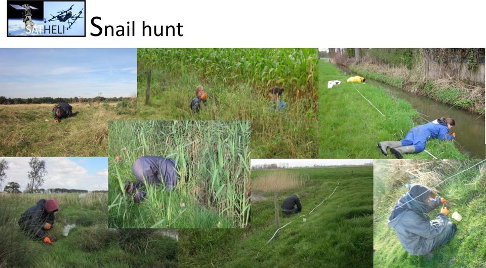
11 Snail hunt Snail hunt 11
12 Snail collection and cercarial shedding 12

13 Infection status cattle 13

14 Longitudinal study Snail abundance associated significantly/positively with SWB type trenches Geographic region Bruges (soil type) Total monthly precipitation Soil and water PH Occurrence of buttercups Summer infection' Winter infection not/negatively with Monthly temperature Mowed pastures Water temperature Presence of reed-like plant species Trench No comparable differences in F. hepatica prevalence in cattle 14

15 OBIA classification strategy Soil type Rainfall SWB type HELI Seeds SAT OBIA SWB map Farm-level prediction of snail risk Risk mapping for F. hepatica occurrence Overall SWB detection accuracy reached up to 87%. 15

16 Risk mapping for F. hepatica occurrence 16

17 Project output D oleire-oltmanns, S., Van Coillie, F. M.B., Hantson, W. (20 ), UAS mapping in Morocco and Belgium Evaluation of a fixed-wing and a multicopter UAS (in review) De Roeck, E., Van Coillie, F., Soenen, K., Charlier, J., Vercruysse, J., Hantson, W., Ducheyne, E., Hendrickx, G., De Wulf, R. (2014). Finescale mapping of vector habitats using very high resolution satellite imagery: a case-study on liver fluke, Geospatial Health (in press) Charlier, J., Soenen, K., Vercruysse, J., Van Coillie, F., De Roeck, E., De Wulf, R., Hantson, W., Ducheyne, E., Hendrickx, G., Longitudinal study on the temporal and micro-spatial distribution of Galba truncatula in four farms in Belgium as a base for small-scale risk mapping of Fasciola hepatica, Parasite and Vectors (in press) Hantson, W., Ducheyne, E., Soenen, K., Charlier, J., Vercruysse, J., De Roeck, E., Van Coillie, F., De Wulf, R., Hendrickx, G. (20 ). Very High Resolution UAV Image processing using Open Source Tools (in preparation) Charlier, J., Meyns, T., Soenen, K., Vercruysse, J. (2013). Monitoring gastrointestinal nematode and liver fluke infections in Belgium by bulk-tank milk ELISA: Are we making progress in parasite control? Vlaams Diergeneeskundig tijdschrift 82 (1), Van Coillie, F., De Wulf, R., Soenen, K., Charlier, J., Vercruysse, J., Hantson, W., Ducheyne, E., Hendrickx, G.. A concept for spatiotemporal characterisation of small water bodies. Luxembourg Earth Observation & Integrated Applications Day, Luxemburg, March De Roeck, E., Van Coillie, F., De Wulf, R., Soenen, K., Charlier, J., Vercruysse, J., Hantson, W., Ducheyne, E., Hendrickx, G.. Satheli Spatio-temporal characterisation of small water bodies using very high resolution satellite and helicopter imagery. EPCN 2012: Little things mean a lot - understanding the role of ponds in a changing world, Luxemburg, June

18 Project output Soenen, K., Vercruysse, J., De Roeck, E., Van Coillie, F., De Wulf, R., Hantson, W., Ducheyne, E., Hendrickx, G. & Charlier, J.. Liver fluke infection: characterization and disease risk of small water bodies as a complementary tool for disease control. Belgian Society for Parasitology, Antwerp, Belgium, October De Roeck, E., Van Coillie, F., De Wulf, R., Soenen, K., Charlier, J., Vercruysse, J., Hantson, W., Ducheyne, E., Hendrickx, G.. Spatiotemporal characterisation of small water bodies, habitats of liver fluke vectors. Eurisy, Lille, France, October Hantson, W., Ducheyne, E., Hendrickx, G., Soenen, K., Charlier, J., Vercruysse, J., De Roeck, E., Van Coillie, F., De Wulf, R.. SATHELI: Spatio-Temporal Characterisation Of Small Water Bodies Using Very High Resolution UAV Imagery, MultiTemp2013, Banff, Canada, June De Roeck, E., Van Coillie, F., De Wulf, R., Hantson, W., Ducheyne, E., Hendrickx, G.. Object-based change detection: case study on small water bodies. Poster presentation. MultiTemp2013, Banff, Canada, June Hantson, W., Ducheyne, E., Hendrickx, G.. Multi-temporal UAV Image Processing for Habitat Modeling. Poster presentation. MultiTemp2013, Banff, Canada, June Soenen, K., Vercruysse, J., De Roeck, E., Van Coillie, F., De Wulf, R., Hantson, W., Ducheyne, E., Hendrickx, G., Charlier, J.. Farm specific risk assessment for Fasciola hepatica: Putting the pieces together. World Association for the Advancement of Veterinary Parasitology, Perth, Australia, August Soenen, K., Vercruysse, J., Ducheyne, E., Hendrickx, G., Hantson, W., De Roeck, E., Van Coillie, F., De Wulf, R., & Charlier, J.. Smallscale spatial risk assessment for Fasciola hepatica: which factors are crucial? Global Network for Geospatial Health, Naples (Italy), September

19 Project output Ducheyne, E., Hantson, W., Soenen, K., Vercruysse, J., De Roeck, E., Van Coillie, F., Dewulf, R., Charlier, J., Hendrickx G.. Very high resolution risk model for Fasciola hepatica. Global Network for Geospatial Health, Naples (Italy), September 2013 Ducheyne, E., Hantson, W., Soenen, K., Vercruysse, J., De Roeck, E., Van Coillie, F., Dewulf, R., Charlier, J., Hendrickx G.. Very high resolution risk model for Fasciola hepatica. Global Network for Geospatial Health, Naples (Italy), September 2013 Hantson, W., Ducheyne, E., De Roeck, E., Van Coillie, F., Dewulf, R., Soenen, K., Charlier, J., Vercruysse, J., Hendrickx, G.. SATHELI: spatio-temporal characterization of small water bodies. Global Network for Geospatial Health, Naples (Italy), September 2013 Soenen, K., Vercruysse, J., Ducheyne, E., Hendrickx, G., Hantson, W., De Roeck, E., Van Coillie, F., De Wulf, R., Charlier, J. (2013). Towards farm-specific risk maps: which factors determine Galba truncatula abundance? Vlaamse Vereniging voor Veterinaire epidemiologie en economie, Drongen (België) 8 November 2013 De Roeck, E., Van Coillie, F., De Wulf, R., Soenen, K., Charlier, J., Vercruysse, J., Hantson, W., Ducheyne, E., Hendrickx, G.. Spatio- Temporal Characterisation of Small Water Bodies Using Very High Resolution Satellite And Helicopter Imagery. BEODay, Bruges, Belgium, September Soenen K., Vercruysse J., Charlier J.. Focus op leverbot. Dierengezondheidszorg Vlaanderen, Merelbeke (België). December

20 Take home message Potential of VHR RS to efficiently and semi-automatically detect SWB habitats Fine-scale risk mapping at the farm level Improved management advice VHR image acquisition tuned to seasonal peaks in snail abundances of adults/juveniles 20

21 Thank you! 21
ForeCAST : Use of VHR satellite data for forest cartography
 ForeCAST : Use of VHR satellite data for forest cartography I-MAGE CONSULT UCL- Dpt Sciences du Milieu et de l Aménagement du Territoire Description of the partnership I-MAGE Consult Private partner Team
Land Use/Land Cover Map of the Central Facility of ARM in the Southern Great Plains Site Using DOE s Multi-Spectral Thermal Imager Satellite Images
 Land Use/Land Cover Map of the Central Facility of ARM in the Southern Great Plains Site Using DOE s Multi-Spectral Thermal Imager Satellite Images S. E. Báez Cazull Pre-Service Teacher Program University
SatelliteRemoteSensing for Precision Agriculture
 SatelliteRemoteSensing for Precision Agriculture Managing Director WasatSp. z o.o. Copernicus the road to economic development Warsaw, 26-27 February 2015 Activitiesof WasatSp. z o.o. The company provides
Interactions between rodent borne diseases and climate, and the risks for public and animal health
 Interactions between rodent borne diseases and climate, and the risks for public and animal health Mare Lõhmus Climate centrum / SMS / KMF National Veterinary Institute Uppsala, Sweden The source of many
The Future of Geospatial Big Data Giovanni Marchisio, Ph.D., Director Product Development
 The Future of Geospatial Big Data Giovanni Marchisio, Ph.D., Director Product Development Nuclear Power Plant, Doel, Belgium December 10, 2011 WorldView-2 Why Geospatial Big Data? We Are the Innovators
Article available at http://www.parasite-journal.org or http://dx.doi.org/10.1051/parasite/1995023275
 Article available at http://www.parasite-journal.org or http://dx.doi.org/10.1051/parasite/1995023275 FASCIOLA HEPATICA : THE INFLUENCE OF THE DEFINITIVE HOST ON THE CHARACTERISTICS OF INFECTION IN THE
Nature Values Screening Using Object-Based Image Analysis of Very High Resolution Remote Sensing Data
 Nature Values Screening Using Object-Based Image Analysis of Very High Resolution Remote Sensing Data Aleksi Räsänen*, Anssi Lensu, Markku Kuitunen Environmental Science and Technology Dept. of Biological
Big Data: Challenges in Agriculture. Big Data Summit, November 2014 Moorea Brega: Agronomic Modeling Lead The Climate Corporation
 Big Data: Challenges in Agriculture Big Data Summit, November 2014 Moorea Brega: Agronomic Modeling Lead The Climate Corporation Outline THE AGRICULTURAL CHALLENGE DATA SCIENCE MEETS AGRICULTURE THE ROLE
2.3 Spatial Resolution, Pixel Size, and Scale
 Section 2.3 Spatial Resolution, Pixel Size, and Scale Page 39 2.3 Spatial Resolution, Pixel Size, and Scale For some remote sensing instruments, the distance between the target being imaged and the platform,
Using Technology and Big Data to Improve Profits. Matt Darr, Agricultural & Biosystems Engineering
 Using Technology and Big Data to Improve Profits Matt Darr, Agricultural & Biosystems Engineering 2015 THE YEAR OF BIG DATA Why the New Emphasis on Data Today? Autosteering and swath control technology
From a host to the other: the critical role of the short cercariae stage
 Programmes : PNEC TAIPAMOR, Carlsberg Fundation From a to the other: the critical role of the short cercariae stage de MONTAUDOUIN 1 X., DESCLAUX 1 C., JENSEN 2 K.T. 1 Laboratoire d'océanographie Biologique,
UAV Road Surface Monitoring and Traffic Information
 UAV Road Surface Monitoring and Traffic Information Czech Road and Motorway Network New capabilities for Unmanned Aerial Systems Current usage (military operation service) Possible civil usage (possible
Remote Sensing Applications for Precision Agriculture
 Remote Sensing Applications for Precision Agriculture Farm Progress Show Chris J. Johannsen, Paul G. Carter and Larry L. Biehl Department of Agronomy and Laboratory for Applications of Remote Sensing (LARS)
Big Data & Big Opportunities
 Big Data & Big Opportunities Dr. Matt Darr, Iowa State University For a copy of this slide deck please send an email request to darr@iastate.edu Presentation Guiding Principles No intent to be critical
Liver Fluke. Acute Fluke - sheep. Chronic fluke. Costs of liver fluke in adult sheep. Fluke Risk throughout the year
 What can farmers do to protect against liver fluke? Liver Fluke Over a wet summer... Numbers of snails Numbers of fluke within the snails Dr F. M. Lovatt BVScPhD DSHP DipECSRHM MRCVS leading to levels
BASICS OF PRECISION AGRICULTURE (PA)
") BASICS OF PRECISION AGRICULTURE (PA) specific production on particular place specific production, from foot to foot... Same sense: data collection and decision making for small pieces of the field. Particular
BASICS OF PRECISION AGRICULTURE (PA) specific production on particular place specific production, from foot to foot... Same sense: data collection and decision making for small pieces of the field. Particular
Agricultural Production and Research in Heilongjiang Province, China. Jiang Enchen. Professor, Department of Agricultural Engineering, Northeast
 1 Agricultural Production and Research in Heilongjiang Province, China Jiang Enchen Professor, Department of Agricultural Engineering, Northeast Agricultural University, Harbin, China. Post code: 150030
Finnish Meteorological Institute, P.O. Box 503, FI-00101 Helsinki 2. University of Joensuu, Faculty of Forest Sciences, P.O. Box 111, FI-80101 Joensuu
 Storm risks on forestry in Finland - occurrence and risk management Ari Venäläinen 1, Hilppa Gregow 1, Heli Peltola 2, Veli-Pekka Ikonen 2 and Seppo Kellomäki 2 1 Finnish Meteorological Institute, P.O.
Liver fluke an overview for practitioners
 Liver fluke an overview for practitioners Diana J L Williams, BSc, PhD Alison Howell BVSc MSc MRes John Graham-Brown BVSc MSc Juriah Kamaludeen BSc MSc Daniel Smith BSc MSc Veterinary Parasitology, Institute
Science of Life Explorations
 Science of Life Explorations Celebrate the Growing Year: The Farmer s Year A Farmer s Year While you are in school or on a vacation, farmers are working hard to provide us with the foods we eat and the
ENVIRONMENTAL MONITORING Vol. I - Remote Sensing (Satellite) System Technologies - Michael A. Okoye and Greg T. Koeln
 System Technologies - Michael A. Okoye and Greg T. Koeln") REMOTE SENSING (SATELLITE) SYSTEM TECHNOLOGIES Michael A. Okoye and Greg T. Earth Satellite Corporation, Rockville Maryland, USA Keywords: active microwave, advantages of satellite remote sensing, atmospheric
REMOTE SENSING (SATELLITE) SYSTEM TECHNOLOGIES Michael A. Okoye and Greg T. Earth Satellite Corporation, Rockville Maryland, USA Keywords: active microwave, advantages of satellite remote sensing, atmospheric
The Role of Spatial Data in EU Agricultural Policy Analysis
 The Role of Spatial Data in EU Agricultural Policy Analysis Wolfgang Britz Institute for Food and Resource Economics, University Bonn Geospatial Open Source Hosting of Agriculture, Resource and Environmental
.FOR. Forest inventory and monitoring quality
 .FOR Forest inventory and monitoring quality FOR : the asset to manage your forest patrimony 2 1..FOR Presentation.FOR is an association of Belgian companies, created in 2010 and supported by a university
Monitoring Overview with a Focus on Land Use Sustainability Metrics
 Monitoring Overview with a Focus on Land Use Sustainability Metrics Canadian Roundtable for Sustainable Crops. Nov 26, 2014 Agriclimate, Geomatics, and Earth Observation Division (ACGEO). Presentation
Bachelor of Geospatial Science Inaugural intake 2015
 Bachelor of Geospatial Science Inaugural intake 2015 Aleen Prasad and Dr Nick Rollings Geospatial Science Unit School of Geography, Earth Science and Environment The University of the South Pacific Geospatial
Guy Carpenter Asia-Pacific Climate Impact Centre, School of energy and Environment, City University of Hong Kong
 Diurnal and Semi-diurnal Variations of Rainfall in Southeast China Judy Huang and Johnny Chan Guy Carpenter Asia-Pacific Climate Impact Centre School of Energy and Environment City University of Hong Kong
UPDATING OBJECT FOR GIS DATABASE INFORMATION USING HIGH RESOLUTION SATELLITE IMAGES: A CASE STUDY ZONGULDAK
 UPDATING OBJECT FOR GIS DATABASE INFORMATION USING HIGH RESOLUTION SATELLITE IMAGES: A CASE STUDY ZONGULDAK M. Alkan 1, *, D. Arca 1, Ç. Bayik 1, A.M. Marangoz 1 1 Zonguldak Karaelmas University, Engineering
USE OF REMOTE SENSING FOR MONITORING WETLAND PARAMETERS RELEVANT TO BIRD CONSERVATION
 USE OF REMOTE SENSING FOR MONITORING WETLAND PARAMETERS RELEVANT TO BIRD CONSERVATION AURELIE DAVRANCHE TOUR DU VALAT ONCFS UNIVERSITY OF PROVENCE AIX-MARSEILLE 1 UFR «Sciences géographiques et de l aménagement»
COTTON WATER RELATIONS
 COTTON WATER RELATIONS Dan R. Krieg 1 INTRODUCTION Water is the most abundant substance on the Earth s surface and yet is the most limiting to maximum productivity of nearly all crop plants. Land plants,
CCI-HYDR Perturbation Tool. A climate change tool for generating perturbed time series for the Belgian climate MANUAL, JANUARY 2009
 CCI-HYDR project (contract SD/CP/03A) for: Programme SSD «Science for a Sustainable Development» MANUAL, JANUARY 2009 CCI-HYDR Perturbation Tool A climate change tool for generating perturbed time series
BSc in Environmental and Conservation Sciences Wildlife and Rangeland Resources Management Major
 Faculty of Agricultural, Life & Environmental Sciences Undergraduate Student Services 2-31 General Services Building www.ales.ualberta.ca Tel: 780.492.4933 Edmonton, Alberta, Canada T6G 2H1 new2ales@ualberta.ca
Liver fluke disease in sheep and cattle
 MARCH 2007 PRIMEFACT 446 (REPLACES AGFACT A0.9.57) Liver fluke disease in sheep and cattle Dr Joseph C. Boray Former Principal Research Scientist (Parasitology) Revised by Dr GW Hutchinson and Stephen
Analysis of Climatic and Environmental Changes Using CLEARS Web-GIS Information-Computational System: Siberia Case Study
 Analysis of Climatic and Environmental Changes Using CLEARS Web-GIS Information-Computational System: Siberia Case Study A G Titov 1,2, E P Gordov 1,2, I G Okladnikov 1,2, T M Shulgina 1 1 Institute of
The Potential Use of Remote Sensing to Produce Field Crop Statistics at Statistics Canada
 Proceedings of Statistics Canada Symposium 2014 Beyond traditional survey taking: adapting to a changing world The Potential Use of Remote Sensing to Produce Field Crop Statistics at Statistics Canada
Contributions of the geospatial fields to monitoring sustainability of urban environments John Trinder. School of Civil and Environmental Engineering
 Contributions of the geospatial fields to monitoring sustainability of urban environments John Trinder School of Civil and Environmental Engineering 2 IMPACT OF HUMAN DEVELOPMENT Humans are modifying the
Chapter Contents Page No
 Chapter Contents Page No Preface Acknowledgement 1 Basics of Remote Sensing 1 1.1. Introduction 1 1.2. Definition of Remote Sensing 1 1.3. Principles of Remote Sensing 1 1.4. Various Stages in Remote Sensing
Modified Richter Scale
 Name Date ID Grade 7 - Science Interim Assessment Third Grading Period 1. Which of the following is NOT affected by the tilt of Earth's axis? Length of day Type of climate Change of seasons Length of year
UPPER COLUMBIA BASIN NETWORK VEGETATION CLASSIFICATION AND MAPPING PROGRAM
 UPPER COLUMBIA BASIN NETWORK VEGETATION CLASSIFICATION AND MAPPING PROGRAM The Upper Columbia Basin Network (UCBN) includes nine parks with significant natural resources in the states of Idaho, Montana,
Spectral Response for DigitalGlobe Earth Imaging Instruments
 Spectral Response for DigitalGlobe Earth Imaging Instruments IKONOS The IKONOS satellite carries a high resolution panchromatic band covering most of the silicon response and four lower resolution spectral
THE ECOSYSTEM - Biomes
 Biomes The Ecosystem - Biomes Side 2 THE ECOSYSTEM - Biomes By the end of this topic you should be able to:- SYLLABUS STATEMENT ASSESSMENT STATEMENT CHECK NOTES 2.4 BIOMES 2.4.1 Define the term biome.
Outline. Multitemporal high-resolution image classification
 IGARSS-2011 Vancouver, Canada, July 24-29, 29, 2011 Multitemporal Region-Based Classification of High-Resolution Images by Markov Random Fields and Multiscale Segmentation Gabriele Moser Sebastiano B.
Remote Sensing and GIS Application In Change Detection Study In Urban Zone Using Multi Temporal Satellite
 Remote Sensing and GIS Application In Change Detection Study In Urban Zone Using Multi Temporal Satellite R.Manonmani, G.Mary Divya Suganya Institute of Remote Sensing, Anna University, Chennai 600 025
Chapter 3 Communities, Biomes, and Ecosystems
 Communities, Biomes, and Ecosystems Section 1: Community Ecology Section 2: Terrestrial Biomes Section 3: Aquatic Ecosystems Click on a lesson name to select. 3.1 Community Ecology Communities A biological
STATISTICAL PROFILE OF CAPE BRETON. Prepared By: Nova Scotia Federation of Agriculture
 STATISTICAL PROFILE OF CAPE BRETON Prepared By: Nova Scotia Federation of Agriculture 1.0 Introduction Agriculture in the Local Economy Agriculture in Cape Breton is characterized by a diversity of farm
The YellowScan system: A test on the oppida of Nages/Roque de Viou (Languedoc, France) Tristan Allouis, PhD Research and Development, L'Avion Jaune
 Tristan Allouis, PhD Research and Development, L'Avion Jaune") The YellowScan system: A test on the oppida of Nages/Roque de Viou (Languedoc, France) Tristan Allouis, PhD Research and Development, L'Avion Jaune L'Avion Jaune : Earth observation data provider UAVs
The YellowScan system: A test on the oppida of Nages/Roque de Viou (Languedoc, France) Tristan Allouis, PhD Research and Development, L'Avion Jaune L'Avion Jaune : Earth observation data provider UAVs
Forage Economics, page2. Production Costs
 Forage Economics Geoffrey A. Benson, Professor Emeritus, Department of Agricultural and Resource Economics, and James T. Green, Jr., Professor Emeritus, Department of Crop Science, NC State University
PASTURE AND GRAZING MANAGEMENT FOR PARASITE CONTROL
 PASTURE AND GRAZING MANAGEMENT FOR PARASITE CONTROL Uma Karki, Ph.D. Assistant Professor and Livestock Specialist Tuskegee University Cooperative Ext. Program and Dept. of Agric. Environ. Sci. How Goats
From Whitehall to orbit and back again: using space in government
 From Whitehall to orbit and back again: using space in government 18 th June 2014 Bristol 25 th June 2014 Liverpool 3 rd July 2014 -Newcastle Space for Smarter Government Programme (ssgp@sa.catapult.org.uk)
Connected Farm Field Services. Dan Rooney InfoAg Conference, July 30, 2014
 Connected Farm Field Services Dan Rooney InfoAg Conference, July 30, 2014 What is Connected Farm? Connected Farm is an integrated operations management solution that combines industry-leading hardware,
OBJECT BASED IMAGE CLASSIFICATION AND WEB-MAPPING TECHNIQUES FOR FLOOD DAMAGE ASSESSMENT
 OBJECT BASED IMAGE CLASSIFICATION AND WEB-MAPPING TECHNIQUES FOR FLOOD DAMAGE ASSESSMENT Ejaz Hussain, KyoHyouk Kim, Jie Shan {ehussain, kim458, jshan}@ecn.purdue.edu Geomatics Engineering, School of Civil
GEOGRAPHIC INFORMATION SOLUTIONS LTD. GPS Data Management & GIS Course
 GEOGRAPHIC INFORMATION SOLUTIONS LTD GPS Data Management & GIS Course 4th Floor-Outbox, Soliz House, Plot 23, Lumumba Avenue, Nakasero, Kampala Uganda. Mobile: +256 778 082 563/+256 712 593 775 Email:
GIS BASED LAND INFORMATION SYSTEM FOR MANDAL SOUM, SELENGE AIMAG OF MONGOLIA
 GIS BASED LAND INFORMATION SYSTEM FOR MANDAL SOUM, SELENGE AIMAG OF MONGOLIA B. Tuul GTZ, Land Management and Fiscal Cadastre project, Government building 12, ALAGCaC, Ulaanbaatar, Mongolia tuul1119@yahoo.com,
Precipitation Remote Sensing
 Precipitation Remote Sensing Huade Guan Prepared for Remote Sensing class Earth & Environmental Science University of Texas at San Antonio November 14, 2005 Outline Background Remote sensing technique
Preparing for Success: Waterfowl Habitat Management Annual Planning by Houston Havens
 Preparing for Success: Waterfowl Habitat Management Annual Planning by Houston Havens While working with private landowners and wetland managers over the past several years, I ve noticed a common theme
UAS as a platform for integrated sensing and big data
 Unmanned Aerial Systems in Precision Agriculture Thursday 30 th January 2014 UAS as a platform for integrated sensing and big data Prof Anthony Furness Visiting Professor Dr Tomas Norton, Senior Lecturer
Modern Agricultural Digital Management Network Information System of Heilongjiang Reclamation Area Farm
 Modern Agricultural Digital Management Network Information System of Heilongjiang Reclamation Area Farm Xi Wang, Chun Wang, Wei Dong Zhuang, and Hui Yang Engineering Collage, Heilongjiang August the First
WATER AND DEVELOPMENT Vol. II - Types Of Environmental Models - R. A. Letcher and A. J. Jakeman
 TYPES OF ENVIRONMENTAL MODELS R. A. Letcher and A. J. Jakeman Centre for Resource and Environmental Studies, The Australian National University, Australia Keywords: environmental models, environmental
AgriInsurance in Canada
 AgriInsurance in Canada Brad Klak, President and Managing Director Merle Jacobson, COO, Operations Division Agriculture Financial Services Corporation Alberta, Canada Agriculture in Canada Total Cash Receipts
4. Which choice below lists the biomes in order from lowest precipitation amounts to highest precipitation amounts?
 Ecosystems and Biomes 1. All of the living organisms in a forest plus their environment is an example of A. a biome. B. a community. C. a population. D. an ecosystem. 2. Which of the following best describes
Passion for Grass. Great in Grass. The Royal Barenbrug Group. Group Board. Europe North America South America Australasia Asia Africa
 The Royal Barenbrug Group The Royal Barenbrug Group Group Board Operating companies Europe North America South America Australasia Asia Africa Operating companies Research locations Research LOCATIONS
Sub-pixel mapping: A comparison of techniques
 Sub-pixel mapping: A comparison of techniques Koen C. Mertens, Lieven P.C. Verbeke & Robert R. De Wulf Laboratory of Forest Management and Spatial Information Techniques, Ghent University, 9000 Gent, Belgium
Introduction to GIS (Basics, Data, Analysis) & Case Studies. 13 th May 2004. Content. What is GIS?
 & Case Studies. 13 th May 2004. Content. What is GIS?") Introduction to GIS (Basics, Data, Analysis) & Case Studies 13 th May 2004 Content Introduction to GIS Data concepts Data input Analysis Applications selected examples What is GIS? Geographic Information
Introduction to GIS (Basics, Data, Analysis) & Case Studies 13 th May 2004 Content Introduction to GIS Data concepts Data input Analysis Applications selected examples What is GIS? Geographic Information
Image Analysis CHAPTER 16 16.1 ANALYSIS PROCEDURES
 CHAPTER 16 Image Analysis 16.1 ANALYSIS PROCEDURES Studies for various disciplines require different technical approaches, but there is a generalized pattern for geology, soils, range, wetlands, archeology,
'Developments and benefits of hydrographic surveying using multispectral imagery in the coastal zone
 Abstract With the recent launch of enhanced high-resolution commercial satellites, available imagery has improved from four-bands to eight-band multispectral. Simultaneously developments in remote sensing
Introduction to the use of GIS in spatial epidemiology using ArcGIS9.x
 Introduction to the use of GIS in spatial epidemiology using ArcGIS9.x Welcome Welcome to the distance learning course the Introduction to the use of GIS in spatial epidemiology using ArcGIS9.x. This on-line
Reading Questions. Lo and Yeung, 2007: 2 19. Schuurman, 2004: Chapter 1. 1. What distinguishes data from information? How are data represented?
 Reading Questions Week two Lo and Yeung, 2007: 2 19. Schuurman, 2004: Chapter 1. 1. What distinguishes data from information? How are data represented? 2. What sort of problems are GIS designed to solve?
Resolutions of Remote Sensing
 Resolutions of Remote Sensing 1. Spatial (what area and how detailed) 2. Spectral (what colors bands) 3. Temporal (time of day/season/year) 4. Radiometric (color depth) Spatial Resolution describes how
PEST MANAGEMENT (CSP Enhancements) January 2006 Enhancement Activity Task Sheet
 January 2006 Enhancement Activity Task Sheet") Reduced risks to ground and surface water quality Lower costs by limiting chemical applications to only when necessary To learn more about Integrated Pest Management go to the following website: http://extension.usu.edu/files/gardpubs/ipm01.pdf
Reduced risks to ground and surface water quality Lower costs by limiting chemical applications to only when necessary To learn more about Integrated Pest Management go to the following website: http://extension.usu.edu/files/gardpubs/ipm01.pdf
PUTTING FORAGES TOGETHER FOR YEAR ROUND GRAZING
 PUTTING FORAGES TOGETHER FOR YEAR ROUND GRAZING Jimmy C. Henning A good rotational grazing system begins with a forage system that allows the maximum number of grazing days per year with forages that are
STANDARDS FOR RANGELAND HEALTH ASSESSMENT FOR SAGEHEN ALLOTMENT #0208
 STANDARDS FOR RANGELAND HEALTH ASSESSMENT FOR SAGEHEN ALLOTMENT #0208 RANGELAND HEALTH STANDARDS - ASSESSMENT SAGEHEN ALLOTMENT #0208 STANDARD 1 - UPLAND WATERSHED This standard is being met on the allotment.
GPS Applications in Agriculture. Gary T. Roberson Agricultural Machinery Systems
 GPS Applications in Agriculture Gary T. Roberson Agricultural Machinery Systems What is a Positioning System? A position information system enables the user to determine absolute or relative location of
An Assessment of the Effectiveness of Segmentation Methods on Classification Performance
 An Assessment of the Effectiveness of Segmentation Methods on Classification Performance Merve Yildiz 1, Taskin Kavzoglu 2, Ismail Colkesen 3, Emrehan K. Sahin Gebze Institute of Technology, Department
Investigation of the Use of Satellite Rainfall Observations in Improving Risk Assessment for Wheat Fusarium Head Blight
 Investigation of the Use of Satellite Rainfall Observations in Improving Risk Assessment for Wheat Fusarium Head Blight June 29, 2007 Candidate Solution Constituents a. Title: Investigation of the Use
Rain on Planting Protection. Help Guide
 Rain on Planting Protection Help Guide overview Rain on Planting Protection allows growers to protect themselves from losses if rain prevents planting from being completed on schedule. Coverage is highly
Remote sensing and GIS applications in coastal zone monitoring
 Remote sensing and GIS applications in coastal zone monitoring T. Alexandridis, C. Topaloglou, S. Monachou, G.Tsakoumis, A. Dimitrakos, D. Stavridou Lab of Remote Sensing and GIS School of Agriculture
MAPPING MINNEAPOLIS URBAN TREE CANOPY. Why is Tree Canopy Important? Project Background. Mapping Minneapolis Urban Tree Canopy.
 MAPPING MINNEAPOLIS URBAN TREE CANOPY Why is Tree Canopy Important? Trees are an important component of urban environments. In addition to their aesthetic value, trees have significant economic and environmental
How to make a Solitary Bee Box
 How to make a Solitary Bee Box **Note: The following instructions include the use of tools that may be dangerous. Ensure there is adult supervision with children. Time: 1 hour People: 1-2+ Materials: Wood
The farm: Placed in the middle of Sealand 250 hektar 5000 pigs 30-110 kg produced Soiltype: JB 6
 The farm: Placed in the middle of Sealand 250 hektar 5000 pigs 30-110 kg produced Soiltype: JB 6 (app. 14% clay, 14 silt, 45% fine sand, 27% sand) The principles of Conservation Agriculture (CA): - Minimum
Internal Parasites Donna K. Carver, DVM, PhD, ACPV
 Internal Parasites Donna K. Carver, DVM, PhD, ACPV Parasites are organisms that live in or on another organism (host) and gain an advantage at the expense of the host. Internal parasites live inside their
Digital Agriculture: Leveraging Technology and Information into Profitable Decisions
 Digital Agriculture: Leveraging Technology and Information into Profitable Decisions Dr. Matt Darr, Ag & Biosystems Engineering Advancing Agricultural Performance and Environmental Stewardship Some material
Chapter D9. Irrigation scheduling
 Chapter D9. Irrigation scheduling PURPOSE OF THIS CHAPTER To explain how to plan and schedule your irrigation program CHAPTER CONTENTS factors affecting irrigation intervals influence of soil water using
ANALYSIS OF HYPERSPECTRAL FIELD DATA FOR DETECTION OF SUGAR BEET DISEASES
 ANALYSIS OF HYPERSPECTRAL FIELD DATA FOR DETECTION OF SUGAR BEET DISEASES Rainer LAUDIEN*, Georg BARETH**, Reiner DOLUSCHITZ*** Department of Agricultural Economics Division: Agricultural Informatics and
TerraColor White Paper
 TerraColor White Paper TerraColor is a simulated true color digital earth imagery product developed by Earthstar Geographics LLC. This product was built from imagery captured by the US Landsat 7 (ETM+)
GEO Joint Experiment for Crop Assessment and Monitoring (JECAM): Template for Research Progress Report
: Template for Research Progress Report") GEO Joint Experiment for Crop Assessment and Monitoring (JECAM): Template for Research Progress Report Date: 17 th February 2015 JECAM Test Site Name: Bambey, Sénégal Team Leader and Members: Cirad Valérie
GEO Joint Experiment for Crop Assessment and Monitoring (JECAM): Template for Research Progress Report Date: 17 th February 2015 JECAM Test Site Name: Bambey, Sénégal Team Leader and Members: Cirad Valérie
River Flood Damage Assessment using IKONOS images, Segmentation Algorithms & Flood Simulation Models
 River Flood Damage Assessment using IKONOS images, Segmentation Algorithms & Flood Simulation Models Steven M. de Jong & Raymond Sluiter Utrecht University Corné van der Sande Netherlands Earth Observation
Farming. In the Standard Grade Geography exam there are three types of farming you need to know about arable, livestock and mixed.
 Types of Farming In the Standard Grade Geography exam there are three types of farming you need to know about arable, livestock and mixed. Arable farms are ones where the main way of making money is by
Land Cover Mapping of the Comoros Islands: Methods and Results. February 2014. ECDD, BCSF & Durrell Lead author: Katie Green
 Land Cover Mapping of the Comoros Islands: Methods and Results February 2014 ECDD, BCSF & Durrell Lead author: Katie Green About the ECDD project The ECDD project was run by Bristol Conservation & Science
Moderate- and high-resolution Earth Observation data based forest and agriculture monitoring in Russia using VEGA Web-Service
 Moderate- and high-resolution Earth Observation data based forest and agriculture monitoring in Russia using VEGA Web-Service Sergey BARTALEV and Evgeny LOUPIAN Space Research Institute, Russian Academy
Remote sensing for habitat mapping and monitoring:
 Remote sensing for habitat mapping and monitoring: experiences from the EU projects SPIN & GEOLAND and other applications Michael Bock Brussels 24 October 2008 Folie 1 > Vortrag > Michael Bock Content
GENERAL WATERING & CARE GUIDE
 GENERAL WATERING & CARE GUIDE Between 30-60 percent of water applied to lawns and gardens is never absorbed by the plants. Water is often wasted because it is applied too quickly and runs off, evaporates
GEOSPATIAL SCIENCE. Program Guide
 MASTER OF SCIENCE GEOSPATIAL SCIENCE Program Guide 2012-2013 Department of Geography University of North Alabama Page 1 MASTER OF SCIENCE IN GEOSPATIAL SCIENCE Department of Geography University of North
Bachelor of Agricultural Business Management Course Structure 2015
 Bachelor of Agricultural Business Management Course Structure 2015 The Charles Sturt University, Bachelor of Agricultural Business Management is a prescribed course with details of curriculum etc. available
CORRELATIONS BETWEEN RAINFALL DATA AND INSURANCE DAMAGE DATA ON PLUVIAL FLOODING IN THE NETHERLANDS
 10 th International Conference on Hydroinformatics HIC 2012, Hamburg, GERMANY CORRELATIONS BETWEEN RAINFALL DATA AND INSURANCE DAMAGE DATA ON PLUVIAL FLOODING IN THE NETHERLANDS SPEKKERS, M.H. (1), TEN
Environmental Remote Sensing GEOG 2021
 Environmental Remote Sensing GEOG 2021 Lecture 4 Image classification 2 Purpose categorising data data abstraction / simplification data interpretation mapping for land cover mapping use land cover class
Emergency Management Service. early warning FLOOD AND FIRE ALERTS. Space
 Emergency Management Service early warning FLOOD AND FIRE ALERTS Space 1 Copernicus at a Glance Copernicus is the European Union s Earth Observation programme: a user-driven space programme under civil
Solar Performance Mapping and Operational Yield Forecasting
 Solar Performance Mapping and Operational Yield Forecasting Supported by Innovate UK Crown copyright Met Office The thing is that Project Overview A collaborative project led by the BRE National Solar
How To Use Data From Copernicus And Big Data To Help The Environment
 Copernicus and Big Data: Challenges and Opportunities Alessandro Annoni European Commission Joint Research Centre www.jrc.ec.europa.eu Serving society Stimulating innovation Supporting legislation Big
APPLICATION OF TERRA/ASTER DATA ON AGRICULTURE LAND MAPPING. Genya SAITO*, Naoki ISHITSUKA*, Yoneharu MATANO**, and Masatane KATO***
 APPLICATION OF TERRA/ASTER DATA ON AGRICULTURE LAND MAPPING Genya SAITO*, Naoki ISHITSUKA*, Yoneharu MATANO**, and Masatane KATO*** *National Institute for Agro-Environmental Sciences 3-1-3 Kannondai Tsukuba
Data Management for the North American Carbon Program
 Image courtesy of NASA/GSFC Data Management for the North American Carbon Program Bob Cook, Eric Sundquist, Tom Boden,, and Peter Thornton RS in NACP Workshop Missoula, MT August 20, 2004 NACP Data and
Application of Remotely Sensed Data and Technology to Monitor Land Change in Massachusetts
 Application of Remotely Sensed Data and Technology to Monitor Land Change in Massachusetts Sam Blanchard, Nick Bumbarger, Joe Fortier, and Alina Taus Advisor: John Rogan Geography Department, Clark University