A FOREST LANDS INFORMATION SYSTEM IN SUPPORT OF SUSTAINABLE MANAGEMENT AND USE OF FORESTS
|
|
|
- Alyson Cobb
- 8 years ago
- Views:
Transcription
1 A FOREST LANDS INFORMATION SYSTEM IN SUPPORT OF SUSTAINABLE MANAGEMENT AND USE OF FORESTS National Cadastre & Mapping Agency () Ministry of Environment 288 Mesogion Ave. Cholargos (Athens) Greece
 Greece www.")
2 Introduction Spatial data and information about forestlands are among the most critical in the context of: Forest and environmental protection Spatial planning Monitoring Forest governance From the Land Administration perspective, it becomes more crucial in determining their definitive boundaries and their associated property rights (tenure) for their sustainable use and development. 2
 for their sustainable use")
3 Sustainable Management and Use of Forests The notion of sustainable management has a very long tradition in Forestry. The first ever written statement about the effects of unsustainable practices regarding forests, referred to the deforestation of the hills around Athens, as a result of logging for shipbuilding and clearcut for agricultural use (Plato, 5 th Century B.C.). The very term 'sustainable' was first used to refer to the sustainable yield of forest resources: forest resources should be used with caution to achieve continuity between increment and felling (Von Carlowitz, 18 th Century A.D.). 3

4 Sustainable Forest Management and Sustainable Development Sustainable forest management (SFM) refers to the stewardship and use of forests and forest lands in a way, and at a rate, that maintains their biodiversity, productivity, regeneration capacity, vitality and their potential to fulfil, now and in the future, relevant ecological, economic and social functions, at local, national and global levels; and that does not cause damage to other ecosystems (FAO, 2013). Sustainable development has a widen meaning and refers to economic, social and environmental development. 4
. Sustainable development has a widen meaning and refers to economic, social and environmental development.")
5 Forestlands Information Systems (FIS) and Land Administration Systems (LAS) FIS refers to the process of recording geospatial data, disseminating and reporting spatial information about forestlands, their associated resources and management activities as well, for their sustainable management. These activities, are associated with national or international commitments made by each country. LA refers to the process of recording and disseminating information about ownership, value and use of land and its associated resources. LA includes, inter alias, cadastre, land registers, land consolidation, valuation, spatial information management for a sustainable management of land resource (Economic Commission for Europe, 1996). 5

6 Forest Lands Administration & SFM Based on work of Williamson et al.,


7 National Efforts towards Forestlands Definitive Delineation 7

8 Background Forestland mapping, along with ownership, known as forest cadastre, is an unaccomplished task for forestry in Greece. The First National Forest Inventory completed in 1985 but not continued ever since. The Forest Cadastre program started in 1976, lead to cadastral maps development for a small area of 320,212 Ha across Greece. The National Cadastre program started in 1997 and is still under development. The Forest Map program started in 1998 and is still under development. 8

9 Background Main reasons for the delay: Lack of institutional capacity over the last century (technology, ICT). Lack of a National Spatial Data Infrastructure (NSDI) (sparse spatial data, duplication, use of multiple geodetic references, no central deposit). Lack of Cadastre System (instead, a registry system of deeds with no spatial reference). Old-fashioned attitudes (act as a barrier towards modernization). Inadequate policies (limited to short term expectations), and above all Lack of Administration will! 9
.")
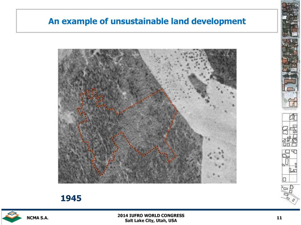
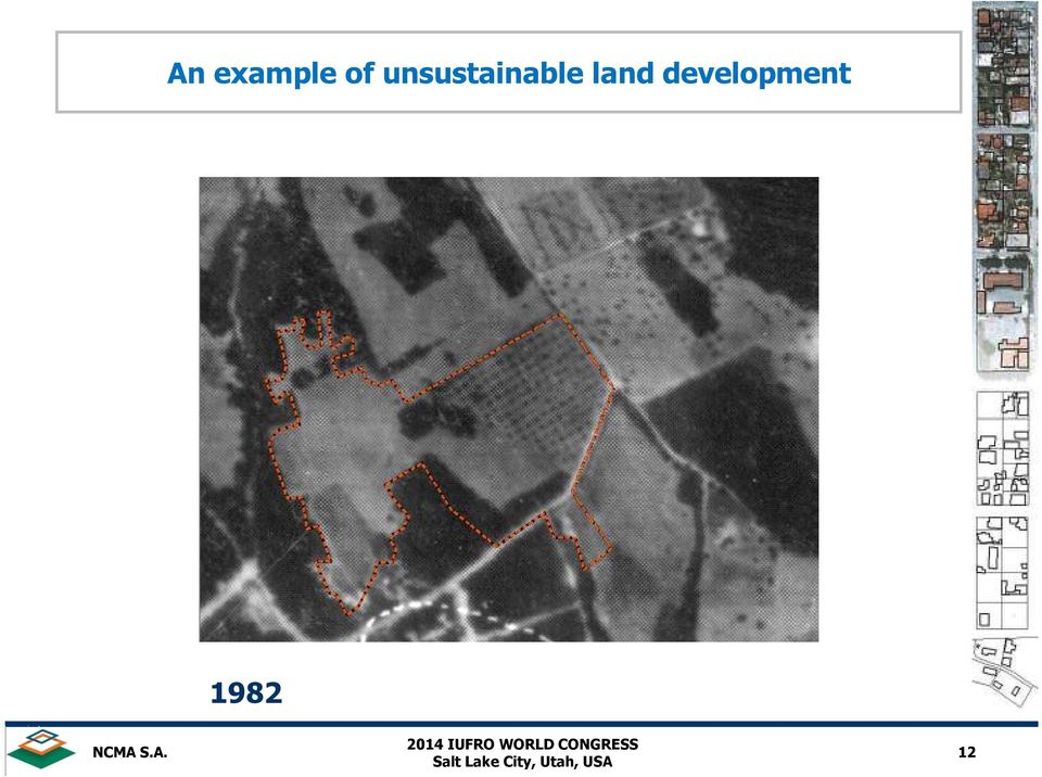
10 Background Thus, Greece lacks a FIS which eventually lead the Administration to favor the circumstantial confirmation of whether certain parcels or areas are forestlands or not! A practice that deprives environment of protection regarding forestlands. Even worse, it has been expanded to all aspects of state lands administration (e.g. urban/non urban, consolidated land or not, etc.) and eventually compromises the principles of sustainable development. 10

11 An example of unsustainable land development
12 An example of unsustainable land development
13 An example of unsustainable land development

14 An example of unsustainable land development Today 14

15 Why we need a National Forestlands Information System? Strategic goals for building a National FIS: Establish the conditions for transparency in forestlands administration, Assist in better decision and policy making, Develop geospatial infrastructure for assessment and monitoring of forestlands and their resources (2 nd level of further development), and Support sustainable forest management and overall sustainable development. 15
, and")
16 Why we need a National Forestlands Information System? Operational goals: present an accurate picture of forestlands geographic location and their boundaries, make relevant, reliable, accurate, and up-to-date spatial forest data and information continuously available to the government, land authorities, business and community as well, provide consistency in reporting, reduce costs through the sharing of information technology, facilitate citizens, professionals, research, and build the land market. 16

17 Towards FIS Development (The Forest Map) Authoritative data is the foundation of any FIS! Explicit geospatial data and information with institutional and legal enforcement and power, across jurisdictional boundaries. 17

18 The Forest Map the leading Greek government company, responsible for the development and operation of national cadastre in Greece, has launched an ambitious program to develop final Forest Maps at the national scale till Cadastre development comprises of all land properties, and therefore cadastral forest mapping is necessary for a successful cadastre establishment. The Forest Map aims to: 1. Assessment and environmental protection of forestlands and 2. Identify and promote state property rights on forestlands through cadastral process. 18

19 The Forest Map Cadastral forest mapping deals with forestlands boundary delineation and their associated characterization (forest/nonforest) based on the landcover characteristics from multi-temporal aerial remotely sensed data and fieldwork. In addition, it takes in account a plethora of existing data, such as administrative deeds issued by local Forest Districts, historical cadastral or land distribution diagrams, court decisions, urban boundaries, etc. to document the legal status of land (forest/nonforest). The Forest Maps are authorized by the State, following a transparent procedure including wide publication of their content via internet, public participation through objections submission, which are examined by independent committees. 19
.")
20 The Forest Map Legend : Forestlands A: Other Lands 20

21 Forest Map Progress in Greece (October 2014) LEGEND Areas with published or final Forest Maps (1.65%) Areas with Forest Maps to be published (9.27%) Areas under implementation (49.49%) Areas with no Forest Maps (39.59%) 21
22 Building the National FIS has taken major steps into setting up a technological infrastructure that supports effectively: The development of a Cadastre and Forest Maps, The operation of Cadastre through the establishment of Cadastral Offices across Greece. Web-enabled services to community. The cornerstone of FIS development is the large scale (1:5.000) nationwide digital orthoimagery and the final authorized Forest Maps. 22
23 Architecture and Components of National FIS 23
24 System Overview (Data and Information Flow through Web and Cadastral Offices/Forest Districts) IIS and Application Server Internet Internet Web client Web client Cadastral Offices/ Forest Districts Data saved to database through ArcGIS server objects Central database (ArcSDE Schema) GIS Custom Software ArcGIS ArcGIS ArcSDE NSDI by NCMA 24
25 Web Application for Electronic Requests Sign In into the web Application* Provide personal data Provide Unique Parcel ID or Geographic Coordinates Use spatial tools for querying Pay a fee Submit the request * The web Application was created using.net framework 25
26 Web Application for Electronic Requests Sign in of new user UserName: Password: Verify Password: Security Question: Security answer: Please repeat the above number Create User Your account has been successfully created! You will soon receive a message with instructions at your address. 26
27 Web Application for Electronic Requests FIS KTIMATOLOGIO Electronic Services Personal Data Requests Help FAQ Contact EXIT You are at the main page of Requests regarding Land Status For your convenience, please use the menu above, using Help when necessary It is important to read the Instructions carefully to avoid mistakes. 27
28 Input of Legal or Physical Personal Data User FIS KTIMATOLOGIO Electronic Services Personal Data Requests Help FAQ Contact Personal Data Objections against Forest Map content Help FAQ Personal Data Contact All data below must be in Capital Greek or Latin characters! Attention! Data with * are necessary to proceed. Surname* EXIT Name* Tax Num. Married Place of birth Date of birth ID Number/Passport* Date of Issue* Type of Issuer* Name of Issuer * Choose Father Surname Father Name* Mother Surname Mother Name Spouse Surname Spouse Name Contact Data Street* From To ZIP cod Foreign Residence City* Area* Country* Choose Phone Number* Mobile* Fax Do you wish to contact you at the above address? Yes No Save 28
29 Web GIS-based Application AOI Spatial Delineation FORESTLANDS INFORMATION SYSTEM GO SCALE LAYERS BASELAYER (ORTHOPHOTOS) POLYGONS LAND STATUS 29
: 1.")
30 Web GIS-based Application Site Searching Queries By Address By Coordinates QUERIES Property ID LEGEND See the explanation of Forest Map Legend AREA DELINEATION Alternatively there are the following methods: TYPE STREET NAME, TOPONYM, POINT OF INTEREST Starts with Includes Text (at least 3 letters): 1. For area delineation you may use the tools at the upper side screen Help for area delineation Examples 2. If you have an AutoCad DXF 2000 (ASCII) file with the boundaries of the area you may uploaded it here. Import Press NEXT to continue Queries Zoom in an area by address, geographic coordinates or parcel ID Press CANCEL to cancel the process Upload polygons By ASCII DXF (AutoCad) files or by ASCII text files 30
31 Web GIS-based Application Forest Map Area of Interest FORESTLANDS INFORMATION SYSTEM SCALE LAYERS BASELAYER (ORTHOPHOTOS) POLYGONS LAND STATUS LEGENT 31
32 Web GIS-based Application Spatial Selection of Forest Map polygon The selected polygon of Forest Map, marked with yellow. 32
33 Certificate of Land Status (Forest/non Forest) 33
34 Concluding Remarks The FIS is a indispensable component of a modern land administration system. Authoritative land spatial data & information is the key element for FIS development. The implementation of the proposed FIS will improve a) administration of state lands and the quality of land information, b) provide secure and update forest land data & information, and c) provide access and legal security. and thus: promote sustainable management and use of forestlands. 34
35 Thank you for your attention 35
Ktimatologio SA «Greek Cadastre IT service management»
 1 Greek Cadastre IT service management E. Lykouropoulos CIO / Ktimatologio SA e-mail: elykouro@ktimatologio.gr 2 Greek Cadastre Definition and project status Definition of cadastre: Organization of legal
ISTANBUL DECLARATION ON CADASTRE IN THE WORLD CADASTRE SUMMIT 2015
 ISTANBUL DECLARATION ON CADASTRE IN THE WORLD CADASTRE SUMMIT 2015 Let us Cadastre the World... 1. INTRODUCTION Land had represented wealth and power from the first settlement to the end of 1700s. As a
Natural Resource-Based Planning*
 Natural Resource-Based Planning* Planning, when done well, is among the most powerful tools available to communities. A solid plan, based on good natural resource information, guides rational land-use
Activites in Survey Department. Data Development Progress
 Introduction Activites in Survey Department Data Development Progress Conclusion Data Development in Brunei Darussalam Presented by : Hj Mohd Jamil bin Hj Mohd Ali Hj Jali bin Hj Nudin Survey Department
Plan on establishment of National Committee on Geographical Names and Spatial Data Infrastructure in Viet Nam *
 UNITED NATIONS E/CONF.104/IP.23 ECONOMIC AND SOCIAL COUNCIL Twentieth United Nations Regional Cartographic Conference for Asia and the Pacific Jeju, 6-9 October 2015 Item 7(b) of the provisional agenda
ArcSDE Spatial Data Management Roles and Responsibilities
 ArcSDE Spatial Data Management Roles and The following discussion outlines the major roles and responsibilities involved in deploying your spatial data and geographic information system (GIS) applications
WISE-Decade: Consolidated BAS & Data Collection Mapping Tool
 November 2015 WISE-Decade: Consolidated BAS & Data Collection Mapping Tool WISCONSIN STATE LEGISLATURE LEGISLATIVE TECHNOLOGY SERVICES BUREAU - GIS 17 WEST MAIN STREET, SUITE 200 MADISON, WI 53703 Version:
User Guide. Foreign Professor/Researcher
 User Guide Foreign Professor/Researcher 1 Registration and Login In order for you to register as a Foreign Professor/Researcher in the General Registry of the Information System "Apella", you need to create
Making Geospatial Data Available and Accessible in Jamaica
 Making Geospatial Data Available and Accessible in Jamaica Presented by Cecille Blake, National GIS Coordinator Office of the Prime Minister, National Spatial Data Management Division 9 th UNRCC New York
WHAT IS GIS - AN INRODUCTION
 WHAT IS GIS - AN INRODUCTION GIS DEFINITION GIS is an acronym for: Geographic Information Systems Geographic This term is used because GIS tend to deal primarily with geographic or spatial features. Information
PDOK Kaart, the Dutch Mapping API
 PDOK Kaart, the Dutch Mapping API Haico van der Vegt*, Leo van der Sluijs* * Cadastre, Land Registry and Mapping Agency of the Netherlands Abstract. PDOK (public services on the map) is a partnership of
Qatar National Geospatial Infrastructure
 Qatar National Geospatial Infrastructure Since 1990 up to 2030 and beyond Mohammad Abd El-Wahab Hamouda GIS Consultant & Chairman of GIS Coordinators Group The Center for GIS Ministry of Municipality and
A GIS PRIMER ON HOW TO ILLUSTRATE SPATIAL DATA AND INFORMATION GENERATED THROUGH NATIONAL FOREST INVENTORIES
 Forestry Department Food and Agriculture Organization of the United Nations A GIS PRIMER ON HOW TO ILLUSTRATE SPATIAL DATA AND INFORMATION GENERATED THROUGH NATIONAL FOREST INVENTORIES PREPARED BY CECILIA
1) Stakeholder participation in ER-PIN planning and ERP design
 Stakeholder participation in ER-PIN planning and ERP design") Grading for ER-PIN Assessments: Color Qualification Analysis Green The indicator is clearly addressed and supported by country stakeholders and other sources of evidence; Reasons for attributed grade should
Grading for ER-PIN Assessments: Color Qualification Analysis Green The indicator is clearly addressed and supported by country stakeholders and other sources of evidence; Reasons for attributed grade should
GIS BASED LAND INFORMATION SYSTEM FOR MANDAL SOUM, SELENGE AIMAG OF MONGOLIA
 GIS BASED LAND INFORMATION SYSTEM FOR MANDAL SOUM, SELENGE AIMAG OF MONGOLIA B. Tuul GTZ, Land Management and Fiscal Cadastre project, Government building 12, ALAGCaC, Ulaanbaatar, Mongolia tuul1119@yahoo.com,
Property Management System
 Property Management System 3 For more information or for a demonstration of the Forté Property Management System please contact: Dylan Rawlins 083 407 6280 dylan@mapserver.co.za The Importance of Property
GHANA S LAND ADMINISTRATION PROJECT: ACCOMPLISHMENTS, IMPACT, AND THE WAY AHEAD. W. ODAME LARBI (PhD, FGhIS) CHIEF EXECUTIVE OFFICER LANDS COMMISSION
 CHIEF EXECUTIVE OFFICER LANDS COMMISSION") GHANA S LAND ADMINISTRATION PROJECT: ACCOMPLISHMENTS, IMPACT, AND THE WAY AHEAD W. ODAME LARBI (PhD, FGhIS) CHIEF EXECUTIVE OFFICER LANDS COMMISSION PRESENTATION OUTLINE Background The National Land Policy
GHANA S LAND ADMINISTRATION PROJECT: ACCOMPLISHMENTS, IMPACT, AND THE WAY AHEAD W. ODAME LARBI (PhD, FGhIS) CHIEF EXECUTIVE OFFICER LANDS COMMISSION PRESENTATION OUTLINE Background The National Land Policy
Geographic Information System Tools for Management of US DOE Sites 14125
 Geographic Information System Tools for Management of US DOE Sites 14125 John Montgomery*, Cliff Carpenter*, Leonard Turton**, Steve Pawel** *US DOE, Office of Legacy Management **S.M. Stoller Corporation
COUNTRY REPORT GEOSPATIAL INFORMATION MANAGEMENT IN NEPAL
 COUNTRY REPORT ON GEOSPATIAL INFORMATION MANAGEMENT IN NEPAL Government of Nepal Ministry of Land Reform and Management SURVEY DEPARTMENT PO Box 9435 Min Bhavan, Kathmandu Nepal Tel : + 977 1 4622713 +
Data Integration with Geospatial Visualization Tools at the Hanford Site 14369
 Data Integration with Geospatial Visualization Tools at the Hanford Site 14369 Brett Simpson*, Marisa Renevitz**, Jon Peschong*** * Vista Engineering Technologies, supporting Mission Support Alliance at
1) Stakeholder participation in ER-PIN planning and ERP design
 Stakeholder participation in ER-PIN planning and ERP design") Grading for ER-PIN Assessments: Color Qualification Analysis Green The indicator is clearly addressed and supported by country stakeholders and other sources of evidence; Yellow The indicator is partially
Grading for ER-PIN Assessments: Color Qualification Analysis Green The indicator is clearly addressed and supported by country stakeholders and other sources of evidence; Yellow The indicator is partially
State of North Dakota. GIS Program Strategic Plan 2015-2017
 State of North Dakota GIS Program Strategic Plan 2015-2017 Prepared By: Bob Nutsch GIS Coordinator Information Technology Department Approved By: North Dakota GIS Technical Committee Date of Publication:
Spatial Data Infrastructure. A Collaborative Network
 Spatial Data Infrastructure A Collaborative Network Solving Challenges Takes Collaboration Social challenges, environmental issues, and economic downturns all take cooperation to solve. Working together
China s Land Registration:Situation, Challenges and Efforts
 China s Land Registration:Situation, Challenges and Efforts Huanle He, China 1. Overview of China's Land Registration 1.1 History of China s Land Registration China's land registration has a very long
The role of the Ina-SDI in supporting the development of the geospatial industry in Indonesia
 GEOGRAFIA Online TM Malaysia Journal of Society and Space 8 issue 1 (69-79) 69 The role of the Ina-SDI in supporting the development of the geospatial industry in Indonesia Asep Karsidi 1 National Coordinating
CIESIN Columbia University
 Conference on Climate Change and Official Statistics Oslo, Norway, 14-16 April 2008 The Role of Spatial Data Infrastructure in Integrating Climate Change Information with a Focus on Monitoring Observed
Aerial imagery and geographic information systems used in the asbestos removal process in Poland
 Towards Horizon 2020 Lasaponara R., Masini N., Biscione M., Editors EARSeL, 2013 Aerial imagery and geographic information systems used in the asbestos removal process in Małgorzata Krówczyńska 1, Ewa
State of Israel Ministry of Housing and Construction Survey of Israel. system for the Israeli real estate market
 State of Israel Ministry of Housing and Construction Survey of Israel A Location Based Business Intelligence (LBBI) A system for the Israeli real estate market Established in 1920 by the British Mandate
Commercial Internet Mapping Impacts on Government Investments in GIS. Wansoo Im, Ph.D. VERTICES, LLC New Brunswick, NJ
 Commercial Internet Mapping Impacts on Government Investments in GIS Wansoo Im, Ph.D. VERTICES, LLC New Brunswick, NJ Acknowledgements: Research funded by the Korean Land Spatialization Group Principal
SWEDEN - VIETNAM COOPERATION ON LAND ADMINISTRATION REFORM IN VIETNAM
 SWEDEN - VIETNAM COOPERATION ON LAND ADMINISTRATION REFORM IN VIETNAM Prof. Dr. Sc. DANG Hung Vo, Vietnam and Gösta PALMKVIST, Sweden SUMMARY This paper has the purpose to present briefly in the FIG meeting
Improving Land Administration in Brazil From Rural to National Cadastre
 Improving Land Administration in Brazil From Rural to National Cadastre Thiago Marra thiago.marra@incra.gov.br Kilder Barbosa kilder.barbosa@bhe.incra.gov.br Eduardo Aguilar de Oliveira (presenter) eduardo.oliveira@mda.gov.br
New IT developments and services in Hungarian Cadastre
 New IT developments and services in Hungarian Cadastre Gyula IVÁN Institute of Geodesy, Cartography and Remote Sensing (FÖMI) Budapest, HUNGARY FIG Commission VII. Annual Meeting 19-25 June, 2005. Madison,
From Low-Cost to Open Source: Choices and Challenges for the Cambodian Land Registration System
 From Low-Cost to Open Source: Choices and Challenges for the Cambodian Land Registration System Gertrude Pieper FM-International Oy FINNMAP OVERVIEW The LMAP / LASSP project Systematic registration: the
THE CAGIS CONSORTIUM DATA SERVICES PRICING POLICY
 THE CAGIS CONSORTIUM DATA SERVICES PRICING POLICY AMENDED BY THE CAGIS POLICY BOARD ON June 6 th, 2014 Effective date: July 1st 2014 PART A Preamble PART B REGARDING SALE OF DATA SERVICE PRODUCTS TABLE
Quick Reference Guide Classic vs. New
 This Quick Reference Guide has been created to help current DataTree users understand the differences between the Classic and New DataTree application. PROPERTY REPORTS Property Detail Report DataTree
From CAD to GIS: Editing and Distributing Geographic Information from CAD Software
 From CAD to GIS: Editing and Distributing Geographic Information from CAD Software Tzvika EL-AZ, Israel Key words: GIS, GeoERP, FELIS, GIS-ERP, Land and property system SUMMARY One of the challenges related
CADASTRE OF REAL ESTATES IN THE CZECH REPUBLIC MAIN CHARACTERS AND EVOLUTION TRENDS
 CADASTRE OF REAL ESTATES IN THE CZECH REPUBLIC MAIN CHARACTERS AND EVOLUTION TRENDS SVATAVA DOKOUPILOVÁ CZECH OFFICE FOR SURVEYING, MAPPING AND CADASTRE PCC workshop ROME 10 11.12.2008 CONTENT Basic data
Spatial Data Warehouse (SDW) & AltaLIS. Presentation to NSGIC. National States Geographic Information Council. Annapolis, Maryland.
 & AltaLIS. Presentation to NSGIC. National States Geographic Information Council. Annapolis, Maryland.") Spatial Data Warehouse (SDW) & AltaLIS Presentation to NSGIC National States Geographic Information Council Annapolis, Maryland February 24, 2013 Spatial Data Warehouse (SDW) & AltaLIS A DATA related Public-Private
Spatial Data Warehouse (SDW) & AltaLIS Presentation to NSGIC National States Geographic Information Council Annapolis, Maryland February 24, 2013 Spatial Data Warehouse (SDW) & AltaLIS A DATA related Public-Private
GEOGRAPHIC INFORMATION SYSTEMS
 GEOGRAPHIC INFORMATION SYSTEMS WHAT IS A GEOGRAPHIC INFORMATION SYSTEM? A geographic information system (GIS) is a computer-based tool for mapping and analyzing spatial data. GIS technology integrates
ANNEX 7.1 Guide to Land Acquisition and Compensation (GLAC) LAND ACQUISITION
 LAND ACQUISITION") ANNEX 7.1 Guide to Land Acquisition and Compensation (GLAC) LAND ACQUISITION Overview Expropriation is a legal way to enable the government or a public legal entity to use immovable assets owned by natural
ANNEX 7.1 Guide to Land Acquisition and Compensation (GLAC) LAND ACQUISITION Overview Expropriation is a legal way to enable the government or a public legal entity to use immovable assets owned by natural
The following organizations were visited during 9 working days. Names of contact persons are listed under the paragraph: 7. References.
 Strengthening Monitoring, Assessment, and Reporting on Sustainable Forest Management in Asia (GCP/INT/988/JPN) MAR Working Paper 38 Anders Wellving FAO Consultant 2010-08-10 Information systems for monitoring,
Basics on Geodatabases
 Basics on Geodatabases 1 GIS Data Management 2 File and Folder System A storage system which uses the default file and folder structure found in operating systems. Uses the non-db formats we mentioned
Service Level Policy. San Diego Geographic Information Source. City and County of San Diego. by and between. and. Version 1.1 Revised January 12, 2011
 Service Level Policy by and between San Diego Geographic Information Source and City and County of San Diego Version 1.1 Revised January 12, 2011 TABLE OF CONTENTS REVISION HISTORY... 3 INTRODUCTION...
ArcGIS Framework Plug-In: Extending the ArcGIS Desktop for ANSI Standard Framework Data to Support Government Decision Making
 ArcGIS Framework Plug-In: Extending the ArcGIS Desktop for ANSI Standard Framework Data to Support Government Decision Making Final Project Report October 28, 2008 Agreement Number Organization Project
GIS Initiative: Developing an atmospheric data model for GIS. Olga Wilhelmi (ESIG), Jennifer Boehnert (RAP/ESIG) and Terri Betancourt (RAP)
, Jennifer Boehnert (RAP/ESIG) and Terri Betancourt (RAP)") GIS Initiative: Developing an atmospheric data model for GIS Olga Wilhelmi (ESIG), Jennifer Boehnert (RAP/ESIG) and Terri Betancourt (RAP) Unidata seminar August 30, 2004 Presentation Outline Overview
GIS Initiative: Developing an atmospheric data model for GIS Olga Wilhelmi (ESIG), Jennifer Boehnert (RAP/ESIG) and Terri Betancourt (RAP) Unidata seminar August 30, 2004 Presentation Outline Overview
Polish Spatial Data Infrastructure - from the Concept towards its Implementation
 Polish Spatial Data Infrastructure - from the Concept towards its Implementation 8th EC-GI&GIS Workshop ESDI A Work in Progress Dublin, July 3-5 June 2001 r. Adam Linsenbarth, Ewa Wysocka Institute of
SiNErGIC - A NEW APPROACH TO CADASTRE
 SiNErGIC - A NEW APPROACH TO CADASTRE Rui Pedro JULIÃO, Catarina ROQUE and José Pedro NETO, Portugal Key words: Cadastre, Digital Cadastre, e-governance, Information Systems, Portugal SUMMARY Portugal
Building & Developing the Environmental
 Building & Developing the Environmental Web Explorer for Riyadh City Authors: Engineer Yousef Bin Othman Al-Fariheedi Manager of Environmental Data Unit Environmental Management and Protection Department
Using SSH Secure Shell Client for FTP
 Using SSH Secure Shell Client for FTP The SSH Secure Shell for Workstations Windows client application features this secure file transfer protocol that s easy to use. Access the SSH Secure FTP by double-clicking
Mapping Application for Resource Planning
 Mapping Application for Resource Planning Wyoming Association of Conservation Districts Cathy Rosenthal, WACD Nephi Cole, NRCS SuiteWater Concept Create an Internet application to support WACD Natural
Ministry of Food Production Land and Marine Affairs Lands and Surveys Division
 Ministry of Food Production Land and Marine Affairs Lands and Surveys Division THE PARCEL INDEX MAP Cadastral Records and Cadastral Management at the Lands and Surveys Division, Trinidad and Tobago Alicia
Online Data Delivery System
 Version: February 2014 Version 3.0 Disclaimer PSMA Australia believes this publication to be correct at the time of printing and does not accept responsibility for any consequences arising from the use
Applications of Mobile GIS in Forestry South Australia
 Applications of Mobile GIS in Forestry South Australia D. T. Battad a, P. Mackenzie b a South Australian Forestry Corporation, Mt. Gambier, South Australia, Australia 5290 - battad.dionisio@forestrysa.com.au
Step 2. Open ArcMap, set Projection to State Plane NAD 83 Feet Apply
 GIS III Exercise 01 Create a Database & Map Urban Land Use Jan 2010 Student Learning Outcomes: Import table data into an MS Access database; NOTE: DOS 8.3 naming is required for files being imported into
Abstract. Introduction
 Data Replication and Data Sharing Integrating Heterogeneous Spatial Databases Mark Stoakes and Katherine Irwin Professional Services, Safe Software Inc. Abstract Spatial data warehouses are becoming more
Development of an Urban Disaster Management System Based On a Geographical Information System
 Development of an Urban Disaster Management System Based On a Geographical Information System Kurtulus Erinc Akdogan, Volkan Caliskan, Mustafa Orcun Kara, Mehmet Bilgekagan Cintimur kurtulus.akdogan@pro-line.com.tr,
ANUKRET ON ORGANIZATION AND FUNCTIONING OF THE MINISTRY OF LAND MANAGEMENT, URBANIZATION AND CONSTRUCTION
 Royal Government of Cambodia Anukret /62ANKR.BK/Jul20,99 Document prepared by the MLMUPC Cambodia, supported by ADB TA 3577 and LMAP TA GTZ. ANUKRET ON ORGANIZATION AND FUNCTIONING OF THE MINISTRY OF LAND
Process Management for Effective Disposition of State Land in Korea
 Young-ho LEE, Korea Key words: Business Process Management (BPM), disposition, work process analysis SUMMARY Recent information technology infrastructure has been growing the new technology of efficient
EMaRT possibilities for the use of innovative web technologies in monitoring of Natura 2000 territories
 5 th Symposium Conference Volume for Research in Protected Areas pages 813-817 10 to 12 June 2013, Mittersill EMaRT possibilities for the use of innovative web technologies in monitoring of Natura 2000
National Levee Database (NLD) Data Management Tool (DMT) Levee Data Manager User Manual 1.2
 Data Management Tool (DMT) Levee Data Manager User Manual 1.2") National Levee Database (NLD) Data Management Tool (DMT) Levee Data Manager User Manual 1.2 Prepared for (USACE) Cold Regions Research and Engineering Laboratory (CRREL) October 26, 2012 Document Change
National Levee Database (NLD) Data Management Tool (DMT) Levee Data Manager User Manual 1.2 Prepared for (USACE) Cold Regions Research and Engineering Laboratory (CRREL) October 26, 2012 Document Change
Welcome to Mobile Banking. Sunflower Bank Mobile Banking Personal User Guide
 Welcome to Mobile Banking Sunflower Bank Mobile Banking Personal User Guide Mobile Banking User Enrollment Sunflower Bank s Mobile Banking provides fast and secure access to your personal accounts so you
User Manual 03/12/2014. A collaborative effort by
 User Manual 03/12/2014 A USER GUIDE DESIGNED TO HELP CREATE AND MAINTAIN PERSONAL ACCOUNTS IN mynhdoe, THE NH DEPARTMENT OF EDUCATION SINGLE SIGN-ON SYSTEM FOR ACCESSING SECURE APPLICATIONS A collaborative
1. Abstract. 2. The Problem / Need for the Program
 Program Information: Montgomery County, Maryland Program Title: Integration of GIS Web Services with the 311 Call Center Program Category: # 14 Information Technology 1. Abstract Montgomery County s Department
2006-2007 Learning Technologies Grants Proposal (COVER PAGE) Project Information
 Project Information") 2006-2007 Learning Technologies Grants Proposal (COVER PAGE) Project Information The Development of a Web-enable map server to enhance Ecological Training Project Title Project Director Elizabeth Kramer
2006-2007 Learning Technologies Grants Proposal (COVER PAGE) Project Information The Development of a Web-enable map server to enhance Ecological Training Project Title Project Director Elizabeth Kramer
NBT BANK MOBILE BANKING. How To Guide
 Table of Contents personal and business banking customers How to Enroll...3 Accessing and Using NBT Bank Mobile Banking...5 Welcome to the NBT Bank Mobile Banking Application...7 Using Mobile Deposit...8
The Delaware DataMIL A Pilot Project for The National Map. April 18, 2002 Delaware GIS Conference: Connecting Communities
 The Delaware DataMIL A Pilot Project for The National Map April 18, 2002 Delaware GIS Conference: Connecting Communities The DataMIL Team University of Delaware Christina Callahan, Research & Data Management
BC Community Health Atlas An interactive mapping tool for population health data
 An interactive mapping tool for population health data Rita Zhang, MPH Epidemiologist Population & Public Health Program Provincial Health Services Authority Bob Nicholson, MA Business Analyst Strategic
Global Fire Email Alerts from FAO s Global Fire Information Management System
 Global Fire Email Alerts from FAO s Global Fire Information Management System http://www.fao.org/nr/gfims/email-alerts/en/ 1.0 Rationale Fire is an important ecosystem disturbance resulting in land cover
COURSE CATALOGUE 2013/2014
 COURSE CATALOGUE 2013/2014 Field: COMPUTER SCIENCE Programme: Master s Degree Programme in Advanced Programming and Databases Length of studies: 2 years (4 semesters) Number of ECTS Credits: 120 +20 for
SAMPLE: DO NOT COMPLETE
 EXP: EXPERIENCE POINT PROCEDURE Use the EXP-W experience worksheets, EXP-P professional profiles and EXP-S summary sheet to document your GIS professional experience. The Experience Schedule (next page)
BROKERAGES AND NETWORKS: AN APPROACH TO MAKING GEOINFORMATION MORE AVAILABLE IN AFRICA
 BROKERAGES AND NETWORKS: AN APPROACH TO MAKING GEOINFORMATION MORE AVAILABLE IN AFRICA Craig Schwabe Director: GIS Centre Human Sciences Research Council (HSRC) Sives Govender, Gina Weir-Smith and Jacob
Before you begin: To get started:
 Before you begin: CPA Certificates, PA Licenses, and/or permits to practice public accounting expire each year on the last day of your birth month. The renewal process is open to you for three months;
Forest Inventory Strategic Plan
 February 2013 Ministry of Forests, Lands and Natural Resource Operations Forest Inventory Strategic Plan The forest inventory program outlined in this strategic plan will help the Ministry of Forests,
Frequently Asked Questions: Wetlands Mapper
 Frequently Asked Questions: Wetlands Mapper December 2015 Mapper Content and Display How does the public access the new Mapper? The Wetlands Mapper can be found at: http://www.fws.gov/wetlands/ Does the
Chapter 1b - Priority Map Development
 North Carolina s Forest Resources Assessment A statewide analysis of the past, current and projected future conditions of North Carolina s forest resources 2010 Chapter 1b - Priority Map Development This
EXTENSION ACTIVITY SUPPORT SYSTEM (EASY) DEMONSTRATOR USE CASES
 DEMONSTRATOR USE CASES") EXTENSION ACTIVITY SUPPORT SYSTEM (EASY) DEMONSTRATOR USE CASES Use Case Specification Developed for DPI Victoria and Cooperative Research Centre for Spatial Information (CRC SI) Prepared by Innovations
EXTENSION ACTIVITY SUPPORT SYSTEM (EASY) DEMONSTRATOR USE CASES Use Case Specification Developed for DPI Victoria and Cooperative Research Centre for Spatial Information (CRC SI) Prepared by Innovations
.FOR. Forest inventory and monitoring quality
 .FOR Forest inventory and monitoring quality FOR : the asset to manage your forest patrimony 2 1..FOR Presentation.FOR is an association of Belgian companies, created in 2010 and supported by a university
6 CHAPTER 6 DATA MANAGEMENT
 6 CHAPTER 6 DATA MANAGEMENT TABLE OF CONTENTS 6.1 OVERVIEW... 6-1 6.2 DATA COMPONENTS... 6-3 6.2.1 Transportation Project Data... 6-3 6.2.2 Sociocultural or Community Data... 6-4 6.2.3 Environmental Resource
Mongolian National Spatial Data Infrastructure
 Mongolian National Spatial Data Infrastructure S.Enkhtuya Chief of Spatial Data Infrastructure Department of Administration of Land Affairs, Geodesy and Cartography Beijing. 2014 ORGANIZATIONAL STRUCTURE
How to do it Manual No. 3: ArcMap10 in Remote Desktop mode and Landgate slip files. Jeremy Green
 How to do it Manual No. 3: ArcMap10 in Remote Desktop mode and Landgate slip files Jeremy Green Report Department of Maritime Archaeology No. 268 2010 Getting started with ArcInfo10 The ArcInfo10 exists
Washtenaw County Geographic Information System Strategic Plan
 Washtenaw County Geographic Information System Strategic Plan April 1999 1 Table of Contents Vision, Goals, and Strategies. 3 GIS Timeline 1999-2002. 8 GIS Timeline 1999-2010. 9 Washtenaw County GIS Program
1.2 DEVELOPMENTS AND PROSPECTS IN THE REAL ESTATE MARKET
 This is the English translation of the Monetary Policy 2011-2012, originally published in Greek (in March 2012). 1.2 DEVELOPMENTS AND PROSPECTS IN THE REAL ESTATE MARKET The Greek real estate market continues
GIS for Cadastre Management
 GIS for Cadastre Management ESRI GIS Technology in Europe MAPPING OWNERSHIP VALUATION COMPLIANCE E-GOVERNMENT GIS for Cadastre Management The Framework for Cadastre Systems Since 1969, ESRI, a pioneer
About As. In a team with the best. ESRI Bulgaria is the exclusive distributor of Esri Inc. for Bulgaria. Esri Inc.
 About As ESRI Bulgaria is an IT company, leader in the field of Geographic Information Systems (GIS) on the Bulgarian market. Offering the most advanced high-tech products, solutions and services, ESRI
Urban Planning Community Visualization The Key to Democratic Urban Planning
 Urban Planning Community Visualization The Key to Democratic Urban Planning Copyright 2006 M2MEDIA360 By Steven B. Mullen Steven B. Mullen is principal, ForeSee Consulting Inc.; e mail: smullen@foreseeconsulting.biz.
The State Land Cadastre of Belarus: Moving Forward
 Permanent Committee on Cadastre in the European Union Plenary Meeting under Polish Presidency 21 22 November 2011, Warsaw, Poland The State Land Cadastre of Belarus: Moving Forward Anastasiya Kudryakova
NGIS in Korea. National Geographic Information System in Korea
 NGIS in Korea National Geographic Information System in Korea 1. Background of the NGIS Master Plan / 4 1) Circumstances 2) Background 2. Major Achievement of the First NGIS Master Plan / 6 3. The and
Tracking Tool for SFM/REDD- Plus Projects. Guidance Note v0.2
 Tracking Tool for SFM/REDD- Plus Projects Guidance Note v0.2 Introduction The SFM/REDD- plus tracking tool (TT) aims to measure progress in achieving the impacts and outcomes established at the portfolio
DEPARTMENT OF PUBLIC WORKS AND HIGHWAYS TROUBLE TICKETING SYSTEM
 DEPARTMENT OF PUBLIC WORKS AND HIGHWAYS TROUBLE TICKETING SYSTEM Rocelyn Nicole Alicbusan, Emar Nathniel de Pano, Jed Kevin Fermo, Brian Joseph Tan, and Marivic Tangkeko 1 1 Center for ICT for Development
Technology Trends In Geoinformation
 Technology Trends In Geoinformation Dato Prof. Sr Dr. Abdul Kadir Bin Taib Department of Survey and Mapping Malaysia (JUPEM) Email: drkadir@jupem.gov.my www.jupem.gov.my NGIS 2008 3 rd. National GIS Conference
Gram Panchayat & Ward Boundary Delineation and Assets mapping
 Gram Panchayat & Ward Boundary Delineation and Assets mapping For Rural Development Department & State Election Commission, Govt. of Maharashtra MAHARASHTRA REMOTE SENSING APPLICATIONS CENTRE Autonomous
Intervention on behalf of Denmark, Norway and Ireland on the occasion of the Open Working Group on Sustainable Development Goals meeting on
 Intervention on behalf of Denmark, Norway and Ireland on the occasion of the Open Working Group on Sustainable Development Goals meeting on Sustainable Consumption and Production, including Chemicals and
Introduction to PostGIS
 Tutorial ID: IGET_WEBGIS_002 This tutorial has been developed by BVIEER as part of the IGET web portal intended to provide easy access to geospatial education. This tutorial is released under the Creative
Institute of Natural Resources Departament of General Geology and Land use planning Work with a MAPS
 Institute of Natural Resources Departament of General Geology and Land use planning Work with a MAPS Lecturers: Berchuk V.Y. Gutareva N.Y. Contents: 1. Qgis; 2. General information; 3. Qgis desktop; 4.
Agenzia del Territorio - Largo Leopardi, 5-00185 Roma - THE ITALIAN CADASTRAL SYSTEM MANAGING BODY AGENZIA DEL TERRITORIO
 PLENARY SESSION 1 Knowledge to manage The Italian Cadastre and the Real Estate Taxation Franco Maggio Central Director for Cadastre and Cartography Agenzia del Territorio - Largo Leopardi, 5-00185 Roma
Spatial Data Storage/Data Discovery Terms Definitions
 Spatial Data Storage/Data Discovery Terms Definitions December 17, 2012 (author: Diane Papineau) Document Status: Final Draft General Spatial Data Collection all the spatial data that Montana State Library
National Geographic Information System (NGIS) in Korea
 in Korea") National Geographic Information System (NGIS) in Korea : from a national policy point of view Jongnam Choi Western Illinois University Geospatial Information Research Center Korea Research Institute for
National Geographic Information System (NGIS) in Korea : from a national policy point of view Jongnam Choi Western Illinois University Geospatial Information Research Center Korea Research Institute for
Creating a More Resilient Future. Friday 30 May, 11:00 to 12:30, Rooms S29-31
 Creating a More Resilient Future Friday 30 May, 11:00 to 12:30, Rooms S29-31 Empowering Resilience With GIS ICLEI Smart Resilient Cities Strategic Use of Spatial Systems Jim Geringer, Esri Former Governor,
How to Complete School Returns Online
 1 How to Complete School Returns Online Before you get started, please have to hand your Username (your school s Roll Number) and an up to date PIN & Password. If you do need assistance with this, please
Database Servers Tutorial
 Copyright 1995-2010 Esri All rights reserved. Table of Contents A quick tour of the database servers tutorial........................ 3 Exercise 1: Add a database server to the Catalog tree and create