EFFECTS OF ADIYAMAN BASIN S QUATERNARY NATURAL ENVIRONMENT ON SETTLEMENT DISTRIBUTION AND OTHER HUMAN ACTIVITIES
|
|
|
- Noel Bridges
- 8 years ago
- Views:
Transcription
1 ISSN: e-journal of New World Sciences Academy 2007, Volume: 2, Number: 4 Article Number: C0029 SOCIAL SCIENCES GEOGRAPHY Received: March 2007 Accepted: October Sabri Karadoğan Saadettin Tonbul University of Firat skaradogan@firat.edu.tr Elazig-Turkiye EFFECTS OF ADIYAMAN BASIN S QUATERNARY NATURAL ENVIRONMENT ON SETTLEMENT DISTRIBUTION AND OTHER HUMAN ACTIVITIES ABSTRACT The Adiyaman Basin is situated on the Tectonic-orogenic Border Folds Belt in the very Southern part of Turkey. It has markedly been affected by the natural environment changes in terms of climate and relief conditions in Quaternary period owing to being on the crossing zone. Climatic changes in Pleistocene had influenced on the Paleolithic life. Composition of the settlements had continously changed due to natural enviromental changes. Still today, there have been many changes on the nature of the basin and Atatürk Dam; thereby, Ataturk Dam s Lake has nearly restructured the Late Pleistocene Conditions of it. In this study, is discussed the relationship between the distribution of settlements and human activities in Adiyaman Basin; and also will be examine the interaction between natural environment conditions and human being; and the geographical characteristics of changing throughout the Quaternary. Keywords: Quaternary, Adiyaman Basin, Kahta, Samasota, Atatürk Dam Reservoir, Euphrates River, Pirun, Pirin, Sehremuz, Gri Tille ADIYAMAN HAVZASINDA KUVATERNER DEKİ DOĞAL ORTAM KOŞULLARININ YERLEŞMELERİN DAĞILIŞI VE DİĞER İNSAN FAALİYETLERİ ÜZERİNDEKİ ETKİLERİ ÖZET Adıyaman havzası Türkiye nin en güneyindeki tektonik-orojenik üniteyi oluşturan Kenar Kıvrımları Kuşağı üzerinde yer alır. Havza, iklim ve yerşekilleri bakımından bir geçiş zonunda bulunması nedeniyle Kuvaterner de meydan gelen doğal ortam değişikliklerinden şiddetle etkilenmiştir. Pleyistosen de yaşanan iklim değişiklikleri havzadaki Paleolitik yaşam üzerinde etkili olmuştur. Yerleşmelerin kompozisyonu doğal çevre değişmelerine göre sürekli değişiklik göstermiştir. Bugün halen, havzanın doğal görünümü ve Atatürk Barajı değişmeye devam etmekte; baraj gölü adeta Alt Pleyistosen koşullarını sürekli olarak yenilemektedir. Bu çalışmada, Paleolitik'ten günümüze Adıyaman Havzası ndaki yerleşmelerin dağılışı ile diğer insan faaliyetleri arasındaki ilişkiler ele alınmaktadır. Aynı zamanda, Kuvaterner boyunca doğal ortam koşulları ile insan arasındaki etkileşim ve değişimin coğrafi karakteri incelenecektir. Anahtar Kelimeler: Kuvaterner, Adıyaman Havzası, Kahta, Samsat, Atatürk Barajı, Fırat Nehri, Pirin, Şehremuz, Gri Tille

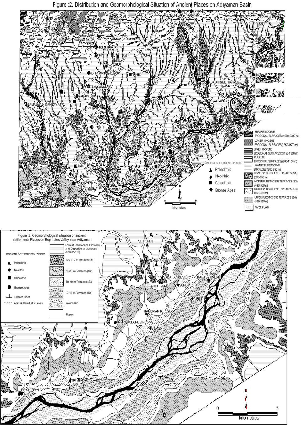
2 1. INTRODUCTION (GİRİŞ) Adiyaman Basin, which is situated on tectonic-orogenic Border Folds belt of the Southern Part, is also on both climatic and topographic crossing zone (Figure 1). For this reason, changes of natural condition of Quaternary has influenced human life and settlements. At the same, there have founded many ancient settlements and civilizations such as Paleolithic, Neolithic, Calcolithic and Bronze ages in this region. Paleolithic life on the basin was affected by the Pleistocene climatic changes. The people lived in the caves for sheltering from cold periods and continued its life on open areas especially near water sources like Euphrates River (in Sehremuz area) in the sultry and dry periods. Geomorphologic studies bring out that Euphrates River vertical cutting in flat-floored valley, taken place at the beginning of Pleistocene. Caves took place on the upper terraces of Euphrates River in the Paleolithic life. After Euphrates River vertical cutting to its water course seasonally, settlements led to lower terraces (Figure 2 and 3). Adiyaman Basin has also the characteristics of Neolithic period. Although the conditions around the basin presented both topographical and climate inconvenient enviromental conditions, Adiyaman Basin situated on the north of Mesopotamia in convenient geographical conditions in the Neolithic age which is correspond to Holocene period. These conditions were thick agricultural soil cover for farming, abundant water resources and streams, Euphrates River with meanders and the wave of herds of prey moving off to the north. Ancient Samsat was very important settlement up to the last centuries. Because, it was on the widest water course between Mesapotamia and Anatolia. Figure 1. Location map of research area (Şekil 1. İnceleme alanının lokasyon haritası) 452

3 Fault structured relief conditions rose as a wall in the north of Adiyaman Basin and formed convenient conditions for protecting in the post Neolithic, Calcolithic and Bronze ages in which security was very important. There were significant settlements such as Arsemeia, Yenikale, Old Kahta in these periods. Current settlements endured from the ancient settlements. Some significant changes occured with covering Atatürk Dam s Lake of Euphrates and some of its tributary s valleys and terraces except for some terraces such as belong to Upper Pleistocene period. First of all, Samsat and many settlement flood by the dam water. Thereby, dam lake restructured the Upper Pleistocene conditions. 2. METHOD AND RESEARCH SIGNIFICATION (YÖNTEM VE ÇALIŞMANIN ÖNEMİ) The settlements and natural enviromental conditions in Adiyaman Basin rapidly changed throughout the Quaternary and had a key importance in the prehistorical Anatolia. In this study, the relationship between natural conditions, settlements and human activities in the Adiyaman from past to present will be evaluated. Area studies are made in the light of archeological data and literature, and location of the each settlement place with its surrounding and according to the geomorphologic development. Old settlement places are mapped by using GIS (Geographic Information System) and they are related to the other maps (Geomorphologic, hydrographic). In order to gain the topographical information about the Former channel of Fırat (the Euphrates) River (before Atatürk Dam was constructed), old maps are used and previous area studies are searched. The entire literature data and the area findings are gathered together under geomorphologic principles. Hereby, settlement history and the natural environment interaction of the area are tried to be introduced. The study is important to consider the historical geographical conditions and human settlements from the point of today s settlement and environment conditions, and to shed light on the geo-archaeology of the area. 3. PALEOLITHIC, B.C AND PRE-PALEOLITHIC (PALEOLİTİK, M.Ö DEN DAHA ÖNCESİ) The ancient human was highly effected by the natural enviromental conditions during Paleolithic. Because landforms, climate conditions and flora were important for their life rather than present. Most important natural enviroment effect was the climate; and human life used to be formed with respect to this conditions in that period of time. Climate changes in the Pleistocene had important effects in Anatolia, depending on this, it was determined topographic features as distribution of flora, soil properties(quality) and also settlements distribution. According to Kökten [1 and 2], foundations of Sub-Paleolithic are mostly found in the high places. It shows that Sub-Paleolithic human walked, settled and hunted in the open fields. Thus, Sub-Paleolithic is a warm and convenient in the interglacial periods. The author states that Lövalzien and Musterien type tools were found on the terraces and caves, climate became rainy and humid and even colder by the time and then passed to Würm glacial period. Kökten [3] states that climate became colder and human had to took cover in the caves in the Middle Paleolithic. Cold and rain climate conditions continued in the Late Paleolithic period, which had considerable effects on human life. Human had to wear thick, find closed and secure places and protect themselves. 453

4 Foundations belong to Lower Paleolithic which are found only on the open area shows climate was conveninet for human in order to live on the open land in the first times of Pleistocene. These were especially found terraces between gravel or sand layer and valley slopes. There foundings shows that Sub-Paleolithic human has advantages of hunting, making tools and even live in the open air. But the need of protecting in the closed places started in the Middle Paleolithic and increase in the Late Paleolithic [4]. Varied surface heritage of the sub paleolithic are found in Gaziantep, Nizip, Urfa, and Adiyaman around. Many hatchets from to years old are found around the Nizip stream. These were made up of mostly silex and the material formed by the solution and erosion of limestones of Euphrates formation [5]. Current studies show that Sub-Paleolithic remains are clustered near Euphrates River and its western part (around Şehremuz). It is stated that tools found around these area are made by the Late Paleolithic human lived in the Riss-Würm interglacial age [6 and 7]. At the end of the Paleolithic Age (Würm period) human are protected in the caves. Both due to the distance and the geologic and geomorphologic structure, the only place for human to protect should be the caves in the Northern Taurus. Remains belong to Late Paleolithic around Euphrates river supports that convenient natural conditions are found in this area. Advantages for the basin are the closeness between the protective mountanious area for the cold times and area near Euphrates river for the warm times, possible transition way for the wave of herds of prey moving off between north and south The Relationship Between the Settlement and Heritage Areas and Natural Enviroment in Adiyaman Basin (Adıyaman Havzasında Palaeolitik Yerleşme ve Buluntu Yerleri İle Doğal Çevre İlişkileri) Paleolithic settlement and remain areas in Adiyaman Basin such as Anep Ridge, Eğriçay, Çakalsuyu, Gri Memo, Hamışkan stream, Kırmızı- Acıdere Ridge, Memişhan location, Miroglu, Salahan location, Sampayadı-Sambayat, Yenikoy, Pirin, Palanlı Pirun hostel, Keciler cave and Sehremuz around [8]. Except for the Anep Ridge that Kahta stream flows into in Euphrates river, Paleolithic settlements are clustered on a line from Keciler cave and Sehremuz. (Figure. 2) It shows that humans changed their location between mountainous area and Euphrates river due to the climatic changes. Keciler Cave settlement which is a settlement of this age is 6-7 km north-northeast of the Adiyaman city center, on the slopes of a calcareous valley. (Photo 1, Map 2) Cave has two openings. It is approximately 20 km lenght and 5-10 km width and on a dominating point to the valley. There are at least 45 figures made by digging inside the cave [8]. Silex sources made Sehremuz and around a choice for ancient human for settlement place. Besides the stone resources, Keluşk stream met humans and animals water need (Figure:3). Fertile flora of Euphrates valley made human to come the area to feed their animals. On the Sehremuz Ridge ondulated plateau is cut by streams and an obscure terrace (S1) is detected [6, 7 and 8]. Pirun/Pirin: South part of the settlement, which is km north-east of Adiyaman city center is open, but there are surrounding mountains in the north. In Karadag s south-west slope looking to Ziyaret Stream exists human made grave and settlement caves besides natural caves. Ancient remains in the area, shows that the area was an important settlement in this age. Paleolithic age heritages are mostly found in the farms in front of the natural caves, around Ziyaret 454

5 Stream Bridge and around Pirun spring/pınarbası. It can be stated that bridge around was a work and settlement area due to paleolithic remains found by many researchers [8]. Photo 1. Palanlı Valley where located Keciler Cave (Resim 1. Keçiler Mağarasının bulunduğu Palanlı vadisi) 4. NEOLITHIC, B.C (NEOLİTİK, M.Ö ) It is believed that Neolithic age was firstly started in the south-east Anatolia region. Therefore, it had convenient conditions and was a flora and natural life field for animals, and this thought is supported by archeological verifications [9, 10 and 11]. Early settlements and transition to production process started on high terraces of Euphrates and thick alluvial and colluvial agriculture areas on the side of mountains with the conveinent climatic features. Due to the danger of flood and risk of sediment on the Euphrates rivers and tributaries valley floor, they settled on meter height Tumulus (Battalhoyuk, Kulafhöyük, Samsathöyük) or on the terraces near river side. Platform made by ancient Samsat could be protected from effusive Euphrates rivers powerful and shifting meanders with the help of hard, cementatedand conglomerates [12]. Human built up a settlement on the protective, hard conglomerates near Euphrates river and lives there for a while at the end of the Pleistocene. After Euphrates river channel deepened 5-8 meters in the near future, they settled on the valley floor for the last 3-4 centuries. (Figure 4) Some other tumulus settled in the Upper Pleistocene conglometares and moreover water resources sprung from these conglomerates explain the relationship between geomorphological structure of conglomerates and resouce crossings and choice of settlement areas Main Neolithic Settlement and Antiquity in Adiyaman Basin (Adıyaman Havzasındaki Başlıca Neolitik Yerleşme ve Buluntu Yerleri) Distinctive characteristic of Neolithic age is the reduction in the number of settlement areas (Figure: 2). The result of transition to agricultural economy led to clustered settlements with the neccessity of division of labor and organization. Areas of settlement are Ziyaret Tepe, Keciler Cave, Cendere, Pirin, Suruk, Girik Tepe, Hayaz Tumulus, Giritille in this age. Cendere cave is in the 35 km of the north-east of Adiyaman city center, on the slopes of Kahta stream. It is on the north-west side of 455

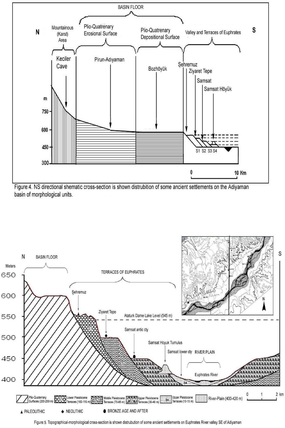
6 the historical Rome bridge. A drilling scale excavation was made by F.K. Dörner and M. Naumann [13]. The cave was detected as Neolithic in the earliest age [14]. First layer of the cave ground to cm was the layer of Early Bronze Age, to cm was the layer of Neolithic Age. Unadjusted approximate dates refers to B.C The pass should be split off at least 15 meters due to the fact that cave was formed by human activities and the entrance was opened to valley ground. It shows that the high enegry of Kahta stream besides the active tectonic and epirogenic movements (Photo 2). Photo 2. Neolithic age cave settlement heritages on the sides of cendere stream that Kahta stream cuts down Yarlica mountain epirogenically (Resim 2. Yarlıca dağını sürempoze bir şekilde yaran Kahta çayının açtığı boğaz yamaçlarında kalmış Neolitik dönem cendere mağaraları) Girik Tepe, situated on the south-southwest of Adiyaman city center, was found by three researchers, R.S. Blaylock, D.H. French [15, 16, 17, 18 and 19], G.D. Summers (1990) making ground research of Tille excavation. In this research some dyed pieces of Halaf period were found on the 102 numbered heritage area. In addition two pieces of flinty arrow/spearhead were found. Gritille, situated on the west slopes of Euphrates valley streaming from northest to southwest before Ataturk dam was made, nowadays, under water, is an elliptic tumulus 80x40 meter on the conic and 150x100 meters together with its foot. Alias Tille, it rose on the conglomeratic pebble accumulation conic. Top of the hill is 24 meter high from Euphrates river water platform before Ataturk dam was made. Certain dimensions of settlement is unknown for the reason that east part of the hill is eroded by Euphrates river. A detailed research on the hill and foot showed that the settlement reached its largest dimention A.D.13. century. Reasons for choosing Gritille as a settlement was near Euphrates river and flat fields and sloped sides on the west. Two spring water resources were found on the vertical east side, last terrace of Euphrates (S4). This feature has a great role in order to choose the area as a settlement. Islands on the ground of Euphrates river became fresh flora for animal herds feeding when all the fields dried at arid season. Growing trees near the channel of the river continously satisfied the wood needs of human settled in the tumulus. Ridges on the west of Gritille supplied quality flint for Paleolithic industry. Grille location had indeed suitable features to life and settlement [20 and 21]. 456
. Photo 2.")
7 Hayaz Höyük was situated on the head facing to a tumulus alike hill in the meeting point of Euphrates rivers stream before Ataturk dam and Kalburcu stream flowing from the north. Before it is flood by dam water, Hayaz village was on the west and relativly on the south terrace of tumulus. Approximately 90 m diameter and 9 m height, Hayazhöyük was a convenient area for settlement, because of the fact that it was on a meeting point of streams. Inhabitants had supplied the need for water from Kalburcu stream and Euphrates river that flew both in the summer and in the winter [22]. Ziyaret Tepe, was on the north of Ancient Samsat settlement, near to Şehremuz Paleolithic area, at the point where Kelusk stream divides into two tributary, on the high terraces of Euphrates. Stone punches, restorer or unrestorer dilgers, Neolithic axe pieces, friction stone pieces were collected by the surface research. In spite of Yalcinkaya stated providently that it was a Early Bronze Age settlement, it can be evaluated as a Neolithic settlement by the remains [21]. Photo 3. First step of neolithic cultural translition on basin floor: Pirun location (Resim 3. Havza tabanında neolitik kültüre geçişin ilk basamağı: Pirun çevresi) Pirun/Pirin Stone hostels, is a settlement in the 4-4,5 km north-east of Adiyaman city center, in opening location of Palanlı Gorge where Keciler cave exists to river basin, made by carving limestone blocs, consisting of many cave/grave rooms. Pirun location was a convenient area for hunter and collector communities (Photo 3). South and east part of the area is open, but the north is surronded by the mountains. Area is convenient for community settlement with this feature. On the south-east of Karadag mass located on the west of Pirun village exists a limited number of natural cave and stone hosiles, besides exists many stone graves. Location is also rich in water supply. As it is known, in the Paleolithic age Palanlı cave and around in the north was the settlement center, but with the changing needs (especially agricultural production dependent on soil) settlement shifted to the south as a reason of diffent areas quest. But, there is not exist natural caves. Consequently, human should carry on the habit by carving limestone blocs [21]. 457

8 5. CALCOLITHIC, B.C (KALKOLİTİK, M.Ö ) Rising in the number of settlement areas besides population increase in the calcolithic age (Figure:2). The people lived in the region maintained their life with agriculture and husbandry and sometimes hunting and fishing. Trade of mine had a significant rise in the age. Developed agriculture and stock-breeding accelerated the changes in daily social life. Consequently, human population increased and new settlement areas existed. If the distribution of calcolithic settlements on the basin investigated, it can be said that agricultural economy and concern of water became more important (Figure. 3). On the other hand, while investigating the calcolithic settlements is that the settlement in the Goksu valley and Kalburcu stream were as a tumulus. It shows that the streams were overfloowing Main Calcolithic Settlement and Antiquity in Adiyaman Basin (Adıyaman Havzasındaki Başlıca Kalkolitik Yerleşme ve Buluntu Yerleri) Adiyaman Tumulus is a tumulus in the Adiyaman city center, also restored by Seljuk Empire, remains in Hınsi Mansur findings of the Arabian period. It is under the treat of urban dwellings (Photo 4). Down Hamili Heritages was in the east of Adiyaman city center, near Kahta river but disappeared under water with the flooding by Ataturk dam lake. Çakalhöyük, It is 11 km in the south-east of Adiyaman city center (Figure. 3). It is a straight settlement. It exists on the east slope of Cakal streams s narrow valley (Figure. 6). There is a strongly water flowing, called as an Arap Pinari in the north. With this water supply, Cakalsuyu, flowing into Ataturk Dam today, supplied water to the ancient inhabitants. Hayaz Tumulus, situated in the south of Adiyaman. Settlement on the meeting point of Kalbucu stream and Euphrates river was the 90 meter diametered conic hill before it is flooded by Ataturk dam lake. Karahöyük, is the 20 meter high, 125 meter diametered tumulus situated in the south-southwest of Adiyaman city center. Photo 4. Adiyaman Tumulus under the treat of urban dwellings today (Resim 4. Günümüzde kentsel yapıların tehdidi altında bulunan Adıyaman Höyüğü) 458
.")
9 Topraktepe, is in the south-southwest of Adiyaman city center. Besides, the lack of Halaf age rough commonity pieces, good quality, fallow based black, brown, orange and red dyed pieces are found. Yassı Tumulus, is the 8 meter high, 150 meter diametered tumulus in the south-southwest of Adiyaman city center, 100 meter west of Yassıhoyuk. Its importance takes its source from the exponatory features of clarifing Obeid age of Adiyaman location. Halaf ages dyed commodity pieces attaract attention [8]. 6. BRONZE AGE AND FOLLOWING (TUNÇ ÇAĞLARI VE SONRASI) Anatolian inhabitants mixed tin into copper and obtained bronze at the beginning of B.C and also they mined the corresponding mines by spilling ans swaging with an extraordinary artcraft. This new period added bronze to the inventories of the latter ages like agricultural, husbandry, weaving, potting, and stronger weapons, thinner decoration materials became possible with the discovery of bronze as a mixture of tin and copper. Technological developments took place in metal processing area as well as the developments in food production. Constructions were still made on stone base over mud bricks, some settlement areas were surrounded by walls [24 and 25]. Other significant events were the intensive trade between Anatolia and Mesapotamia and also introduction of writing to Anatolia [26 and 27]. Some centers in the location of Adiyaman basin started to appear strategically advantageous due to the enviroment and had roles in historical functions. Arsemlia and Samsat had significant importance. After the Bronze Age, some nucleus settlements tend to appear, that arised with the need of protection, water, agriculture and transport and the other activities have gone on so far. Arsemia, an important settlement until Hittites, was the administrative capital of Kommagene and mount Nemrut was the religious capital [28]. Ancient Arsemeia city was located on a dominant gorge from Kahta stream to Malatya (Photo. 5). A deep and narrow gorge made by Kahta streams north-east branch seperates Yenikale and Arsemia. Photo 5. Arsemlia Ancient City setteled on sharp cretins cutting down by Nymphois Stream (on right) and Yenikale (Resim 5. Nymphois Çayının (Eski Kahta Çayı) yardığı sarp kretler üzerine kurulmuş Arsemlia antik kenti (sağda) ve Yenikale) 459
![Its importance takes its source from the exponatory features of clarifing Obeid age of Adiyaman location. Halaf ages dyed commodity pieces attaract attention [8]. 6.](/docs-images/43/6042996/images/page_9.jpg "BRONZE AGE AND FOLLOWING (TUNÇ ÇAĞLARI VE SONRASI) Anatolian inhabitants mixed tin into copper and obtained bronze at the beginning of B.C.")
10 Kommagene was called Nymhp meaning fertile and vital for the reason that it meeting with Cendere stream and then Euphrates river water the country. Nymphois stream (old Kahta stream) was a name given to the stream between two castles in the age of Kommogene and meant fruitful stream [28]. Owing to the unconvenient ground conditions of Samsat (Samosate) and terraces around Euphrates river, it is only possible fact to make evaluations and mappings in the light of literature information [12, 29, 30, 31, 32 and 33]. Ancient city of Kommagene Samsat was located on the west side of Euphrates valley (Photo 6, Figure 4). Samosata was an important center. Because, it was on the crossing road of Melitene, Komana, Hierakome, Tarsa and Zeugma. Samsat settlement was the most clear observed city that the relationship between natural enviroment and settlement could be seen. Samsat tumulus, which was a near river settlement, was in the 700 meter north of the river before Euphrates river changes its bed before it was flooded by dam water. It was consisted of a major tumulus and a terrace surronding it and a down city on Holocene terraces (Figure 4 and 5). Ancient Samsat was the meter high from river waterbed. Mainly, ancient city was situated on S3 terrace system. In the cross sections of Euphrates side, it is seen that the tumulus is the place on a pebble filled height. Terrace, that Calcolitic age material is mostly seen as the first tumulus [32 and 33]. With its old name Samosate, afterwards called Samosatum, Semisat or Sumaisat, Samsat was on the widest area of the Euphrates flat-floored valley, it was most suitable area to cross the river. Slopes bidding the valley floor to the basin floor is topographically pressed and many resources at present. Samsat, consisting of tumulus, terrace and down city, is an important center settled from past to present. It is the most suitable crossing area between Euphrates s west and east part, controlling the transport was an advantegous of Samosata [28]. Photo 6. Ancient Samsat City and tumulus located on Euphrates terraces (Photos belong to before dam lake period) (Resim 6. Fırat sekileri üzerine kurulmuş Samsat antik kenti ve höyüğü, Fotoğraf baraj gölü öncesine aittir) Ancient Samasota Waterway leading from Euphrates and Kahta valley sides is an important question. Samasota waterway lied 40 km, following the meter terraces in order to turn Kahta stream to 460
. Samosata was an important center.")
11 Samasota from the height of 450 meters begining from the middles of Nymphiso stream. Waterway was transfered with arches over the streambeds, with canals on the ridges and slopes and with tunnels through the rocky parts. Interesting results were found in the researches on waterways and features made before the dam lake [29]. Daily water amount flowing to city and also the population is tried to estimate with the help of cross sectios. At the beginning, flow of the canal was 755 lt/sec and daily 66,960 m³ water reached. Even it is stated that in the Roman age the population reached to 50,000, it is a great amount for drinking water. But it could be stated that the water was mostly used for farming and the S3 and S4 terraces were agricultural areas in this period. In the archaeological researches made before Ataturk dam lake, ancient palaces, water canals, castles and some alike constructions and some valuable materials were found on the ancinet Samsat location [29, 32, 33 and 34]. Late Copper Age, Bronze Age, Iron Age, Hellenistic, Roman, Byzantines, Arabian and Seljuck works were clarifed. These were coins, paper and cylinder seals, small sculptures, needles and beads. Variety of materials shows that also the agricultural economy, trade was also important and an active economic activities took place. From the XIV. the layer dated as B.C.XVIII, a bulding with a court furnished by pebbles, inner walls painted black and white, fresco building allged as palace was found. The Building located in the middle of the tumulus as called Mithrides Palace consisting of a big gallery, thought as throne room, many big and small rooms and galleries. The walls were covered with yellow and red frescos [32, 33 and 34]. Samsat settlement area is transfered to its current location due to the flooding caused by Ataturk dam lake in 1988 and lost its importance and dynamism completely. Another settlement area, which was one of the important region in the basin until near future but after, it lost its functions and included to Old Kahta. Significance of Old Kahta comes from its convenient morphological structure for protecting. It was situated on the arduous and inaccessible west steeps of Kahta stream. The oldest buildings of Old Kahta Castle whose construction date are unknown but predicted as Hitites of B.C belongs to Kommagene Empire. Constructing style of the building located on the top of steeps is very marvellous. Water cistern, small mosque, meeting rooms, dungeons, crenels, watergate to the stream and loft stairs, closed transition galleries are present in the castle [28 and 35]. A 400 meter part goes from the castle to the east branch of Kahta stream. It was constructed to supply the water from the stream in a possible seige. On a table, it gives information about the Komagene s capital cities Arsemia and Antiokos. There is a major and deep gallery under the tablet. The excavations made in the castle shows that there exists iron mine. Many findings of ruinous furnace wall and slags were discovered in a excavation made under the management of F.K. Dorner [36] by Winkelman in It is understood that the furnace had bellows. It is thought that these furnaces having bellows might have a connection with the iron processing units. Furnaces were on a side and could utulize the wind. A weld and molting furnace was found in the excavations in The Castle is in its original structure but most of its parts are destructed. The environment and castle have a great potential of tourism with a fascinating scene and nature especially morphological structure. 461
![Interesting results were found in the researches on waterways and features made before the dam lake [29].](/docs-images/43/6042996/images/page_11.jpg "Daily water amount flowing to city and also the population is tried to estimate with the help of cross sectios. At the beginning, flow of the canal was 755 lt/sec and daily 66,960 m³ water reached.")
12 Two developing and growing settlements are present in the basin today. One of them is Adiyaman and the other is Kahta (New). Adiyaman is on senclinal basin in the external line of Southeastern Taurus that form Anatolian part of the Alp-Himalayan orogenic zone, on a place to maintain transition between the basin and the North mountainsous area, on Plio-Quaternary deposits. Location of the city has tansport, hydrographic, land and climatic advantages for settlement. Adiyaman is on the natural and historical crossroad of Anatolia to Mediterranean region (over Gölbaşı-Maraş or over Elbistan) to Southeast Anatolia (over Diyarbakır) and to Syria and Iraq. The Euphrates river has a great important role on the settlement and continuity of Adiyaman city. First nucleus settlement around the Adiyaman city, Perre (Pirin) arised on 5 km the north-east of city center today known as Orenli district and it dates back to Neolithic age. Perre (Pirin) acquired its consideration at the time of Kommagene Empire and became one of the important settlements in the history. Perre (Pirin) was relinquished at the end of the Old age and beginning of the Middle age and settlement area shifted to Girik village in the 5 km north near to present area where the castle stands. New Kahta settlement is founded on the west side of Kahta stream and continued its rapid development. Adiyaman-Siverek-Diyarbakir and Urfa highway before Ataurk dam is certainly affected the development of Kahta. Population overspill because of the costruction of dam lake had significant effect in the degree of development of the settlement. Karakuş Tumulus nearly 5 km north of Kahta dominates the location. Reason for a settlement should be need for dominating the transport between Arsemeia and Samsat. For this reason, settlement factor of new Kahta could be dependent on the crossroad function between north-east and east-west. Kahta settlement is the second biggest settlement area in the region excluding Adiyaman after the population immigrated because of dam late. 7. CONCLUSION (SONUÇ) Settlement in the Adiyaman basin in which natural enviromental conditions rapidly changed in short distances during the Quaternary and which had a key importance in the prehistorical Anatolia and the human activities, were formed due to the natural conditions. Besides, the changes in the physical enviromental conditions especially climatic changes in the Pleistocene, relief features continously affected by the erosion and accumulations by Euphrates river and branches and climate had significant effects on the settlements area selection and other human acivities. The population sometimes lived in the caves and shelves on the north of resarch area, on the southeastern Taurus due to climatic changes, and lived near the Euphrates river terraces in the warn climates (interglacial ages). Advantage of the basin in the Early Paleolithic is the allowance of Euphrates river for transition by flowing with meanders and being on the crossroad of prey flocks between highlands and warm south areas due to the passes in the north. In the Neolithic Age, the Basin had large settlement due to the climate, agriculture, water and transport opportunities. But the high flow of Euphrates river, vertical cutting and lateral erosion affected the settlement options. The people settled on the terraces that have resistant to erosion or made tumulus on meter higher on the valley plain in order to protect from the destructive impacts of streams. Relief conditions in the basin is the convenient conditions when the need of security and protection arised in the Bronze Age. Kommogene Crowns ordered the empire in the castles located on northern 462
 to Southeast Anatolia (over Diyarbakır) and to Syria and Iraq.")
13 steep and high cliffs and at the same time from the palaces surronded by water and land resources. Samsat settlement maintained its importance due to some natural convenient advantages such as being on a dominating area for waterway, on the hard conglomerate terraces away from the Euphrates river s meanders, continuing agricultural activities in the north and wide Plio-Quaternary surfaces allowing feeding even in warm climate on Euphrates river s sand islands. But with the construction of Ataturk dam, natural outlook of Adiyaman basin has changed and Pleistocene conditions are restored. First Samsat and many settlement areas and agricultural lands submergened under water, and a natural environment leading human to adoptation and quests appeared in the basin. REFERENCES (KAYNAKLAR) 1. Kökten, İ.K., (1947). Bazı Prehistorik İstasyonlar Hakkında Yeni Gözlemler, A.Ü.D.T.C.F. Dergisi, Cilt:V, Sayı:2, ss: Kökten, İ.K., (1952). Anadoolu da Prehistorik Yerleşme Yerlerinin Dağılışı Üzerine Bir Araştırma. A.Ü.D.T.C.F. Dergisi Cilt:VI, Sayı:5, ss: Kökten, İ.K., (1964). Karain in Türkiye Prehistoryasındaki yeri, Türk Coğrafya Dergisi, Sayı:22-23, ss: Yalçınkaya, İ., (1985). Araştırmalar Işığında Anadolu Alt Paleolotiği ve Sorunlarına Genel Bir Bakış, A.Ü.D.T.C.F. Antropoloji Bölümü Yayınları, Sayı:12, ss: Güldalı, N., Deroche, A., (1991). Güneydoğu Anadolu da Tarih Öncesi İnsanların Yaşam Ortamları; Özellikle Doğal Mağaralar, Jeomorfoloji Dergisi Sayı:19, ss: , Ankara. 6. Yalçınkaya, İ., (1983). Samsat/Şehremuztepe Çevresi Paleolitik Çağ Araştırmaları, I. Araştırma Sonuçları Toplantısı, İstanbul, ss Yalçınkaya, İ., (1984). Samsat Şehremuz Tepesi Çevresi Paleolitik Çağ Yüzey Araştırmaları, I.A.S.T., Ankara, ss: Harmankaya, S., Tanındı, O., (1996). Türkiye Arkeolojik Yerleşmeleri-1: Paleolitik/Epipaleolitik, Ege Yayınları, Cilt ISBN , İstanbul. 9. Esin, U., (1881). İlk Üretimciliğe Geçiş Evresinde Anadolu ve Güneydoğu Avrupa (G.Ö yılları arası) Doğal Çevre Sorunları. İstanbul Üniversitesi Edebiyat Fakültesi Yay. İstanbul. 10. Tok, G., (Mayıs 2000). Uygarlığın Doğduğu Dönem - Neolilik Çağ, TÜBİTAK Bilim ve Teknik Dergisi. 11. Özgüç, T., (1947). Ön Tarihte Güney ve Güney-Doğu Anadolu un Mukayeseli Stratigrafisi, A.Ü.D.T.C.F. Dergisi, IV/2, ss: Erol, O., (1983). Paleoekolojik Araştırmalarda jeomorfolojinin önemi, Arkeometri Ünitesi Bilimsel Toplantı Bildirileri, Tübitak yayınları no: 566, Ankara. 13. Dörner, F.K., Naumann, R., (1939). Forschungen in Kommagene, İstanbulen Forschungen Bischoff, D., (2004). CANeW archaeological sites databases, Southeastern Turkey, 10th 6th millennia cal BC French, D.H., (1980). Tille Kazısı 1980, II. Kazı Sonuçları Toplantısı, Ankara, ss French, D.H., (1983). Excavatıons at Tille Höyük, V. Kazı Sonuçları Toplantısı, İstanbul, ss: French, D.H., (1985). Tille 1984, XII. Kazı Sonuçları Toplantısı, Ankara, ss: French, D.H., (1987) Tille Arkeoloji Kazısı, IX. Kazı Sonuçları Toplantısı I, Ankara, ss: French, D.H., (1991) Tille Höyük 1989 Arkeoloji Kazısı, XII. Kazı Sonuçları Toplantısı-I, Ankara ss:

14 20. Ellis, R.S., (1985). Gritille 1984, XII. Kazı Sonuçları Toplantısı, Ankara, ss: Harmankaya, S., Tanındı, O., Özbaşaran, M., (1997). Türkiye Arkeolojik Yerleşmeleri-2: Neolitik, Ege Yayınları, ISBN X, İstanbul. 22. Rodenberg, J.J., (1981). Hayaz Höyük Kazısının İlk Sonuçları, III. Kazı Sonuçları Toplantısı, Ankara, ss: Harmankaya, S., Tanındı O., Özbaşaran, M., (1998). Türkiye Arkeolojik Yerleşmeleri-3: Kalkolitik, Ege Yayınları, ISBN , İstanbul. 24. Aktüre, S., (1994). Anadolu da Bronz Çağı Kentleri. Tarih Vakfı Yurt yay. İstanbul. 25. Tuncel, M., (1980). Türkiye de Yerleşmenin Tarihçesine Toplu Bir Bakış, İstanbul Üniversitesi Coğrafya Enstitüsü Dergisi, Sayı:23, ss: , İstanbul. 26. Tunçdilek, N., (1986). Türkiye'de Yerleşmenin Evrimi. İ.Ü. Deniz Bil. Enst. No:4, İ.Ü.Yay. No:3367, İstanbul. 27. Bilgiç, E., (1955). M.Ö. İkibin Yıllarında Mezopotamya-Anadolu Arasında Ticari ve İktisadi Münasebetler, Dokuzuncu Coğrafya Meslek Haftası,Tebliğler ve Konferanslar, ss: , İstanbul. 28. Güney, E., (2001). Antikçağ Türkiye Kentleri, Bilgili Yayın Yapım, İstanbul. 29. İzmirligil, Ü., (1983). Samasota (Samsat) Su Yolu Araştırması, 1982, I. Araştırma Sonuçları Toplantısı, İstanbul, ss: Erol, O., Akkan, E., Elibüyük, M., ve Doğu, A.F., (1987). Aşağı Fırat Bölgesi'nde Bugünkü ve Kuvaterner'deki Doğal Çevre Koşulları: ODTÜ. Aşağı Fırat Projesi, Çalışmaları, Aşağı Fırat Projesi Yayınları. Seri I, No:3, Ankara. 31. Erol, O., (1992). Türkiye'de Arkeometrik ve Jeomorfolojik Araştırmalar, Türk Coğr. Derg.., Sayı:27, ss:27-40, İstanbul. 32. Özgüç, N., (1983). Samsat Kazıları, V. Kazı Sonuçları Toplantısı, İstanbul, ss: Özgüç, N., (1985). Samsat 1984 Yılı Kazıları, VII. Kazı Sonuçları Toplantısı, Ankara, ss: Tırpan, A.A., (1986). Samasota Aşağı Şehir Sur Duvarları, IV. Kazı Sonuçları Toplantısı, Ankara, ss: Durusoy, G., (Mart2005). İzmir. 36. Dörner, F.K., (1966). Recent archaeological research in Turkey: Arsemeia on Nymphaios , Anatolian Studies 16, pp:
. Anadolu da Bronz Çağı Kentleri. Tarih Vakfı Yurt yay. İstanbul. 25. Tuncel, M., (1980).")
15
16
WEATHERING, EROSION, AND DEPOSITION PRACTICE TEST. Which graph best shows the relative stream velocities across the stream from A to B?
 NAME DATE WEATHERING, EROSION, AND DEPOSITION PRACTICE TEST 1. The diagram below shows a meandering stream. Measurements of stream velocity were taken along straight line AB. Which graph best shows the
NATURAL REGIONS OF KENTUCKY
 NATURAL WONDERS As you travel around Kentucky taking pictures, you are excited by what you see. Kentucky offers diverse and amazing sights. The Six Regions In the West, you see the Mississippi River, the
AN IMPORTANT MIDDLE BRONZE AGE CEMETERY AT WEST-CENTRAL ANATOLIA: DEDE MEZARI
 AN IMPORTANT MIDDLE BRONZE AGE CEMETERY AT WEST-CENTRAL ANATOLIA: DEDE MEZARI O. Kocak a, M. Uyumez b, T. Cay c, A. Ilasli b, F. Iscan c a Selcuk University Faculty of Science and Letters, Department of
Design and Re-Use Of Shovadans In Today's Architecture "With Due Attention To Have Thermal Energy Of The Earth"
 RESEARCH INVENTY: International Journal of Engineering and Science ISBN: 2319-6483, ISSN: 2278-4721, Vol. 1, Issue 8 (November 2012), PP 60-64 www.researchinventy.com Design and Re-Use Of Shovadans In
Ancient Greek Arts and Architecture
 Ancient Greek Arts and Architecture Ancient Greek Architecture The earliest buildings built in Greece in the New Stone Age are small houses or huts with wooden walls around them for protection. Later bigger
Chapter 18 Introduction to. A f r i c a
 Chapter 18 Introduction to A f r i c a Ch. 18:1 Landforms & Resources 1. Africa s shape & landforms are the result of its location in the southern part of the ancient supercontinent of. Pangaea Over thousands
Four Short Walks From the Mill
 Four Short Walks From the Mill With directions, duration and length of walk www.ratonera.com (0034) 958 339 560 There are steep sections on most of these walks so please wear boots or stout shoes. A stick
Climate, Vegetation, and Landforms
 Climate, Vegetation, and Landforms Definitions Climate is the average weather of a place over many years Geographers discuss five broad types of climates Moderate, dry, tropical, continental, polar Vegetation:
Stability Assessment of Chamshir Dam Based on DEM, South West Zagros
 2015 2nd International Conference on Geological and Civil Engineering IPCBEE vol. 80 (2015) (2015) IACSIT Press, Singapore DOI: 10.7763/IPCBEE. 2015. V80. 13 Stability Assessment of Chamshir Dam Based
The City Where The Sun Smiles; Alanya
 The City Where The Sun Smiles; Alanya Alanya is a holiday resort located on the south coasts of Turkey with its popular and still-breathing ancient history. The city s unique, natural and blue flagged
Neolithic Shellfish Gathering at Yeşilova: An Ethnoarchaeological View
 Neolithic Shellfish Gathering at Yeşilova: An Ethnoarchaeological View Zafer Derin The significance of shellfish gathering has long been underestimated among archaeologists studying the role of marine
Emergency Safeguarding. of the World Heritage. Site of Byblos
 Emergency Safeguarding of the World Heritage Site of Byblos Emergency Safeguarding of the World Heritage Site of Byblos Introduction Located on the Eastern Mediterranean, 40 km north of Beirut (Lebanon),
not to be republished NCERT MAJOR LANDFORMS OF THE EARTH
 6 You must have seen some of the landform features as shown in the Figure 6.1 below. You will notice that the surface of the earth is not the same everywhere. The earth has an infinite variety of landforms.
Rapid Changes in Earth s Surface
 TEKS investigate rapid changes in Earth s surface such as volcanic eruptions, earthquakes, and landslides Rapid Changes in Earth s Surface Constant Changes Earth s surface is constantly changing. Wind,
THE ORGANIZATION OF LONG-DISTANCE TRADE AND ITS INFLUENCE ON THE SETTLEMENT TYPOLOGY IN ANATOLIA IN THE OTTOMAN SOCIETY
 101 Archi-Cultural Translations through the Silk Road 2 nd International Conference, Mukogawa Women s Univ., Nishinomiya, Japan, July 14-16, 2012 Proceedings THE ORGANIZATION OF LONG-DISTANCE TRADE AND
The Hydrologic Cycle. precipitation evaporation condensation transpiration infiltration surface runoff transport groundwater water table.
 The Hydrologic Cycle Page 1 of 1 Name Directions: The hydrologic cycle consists of the processes that change and move water through the earth s system. Use the terms below to label the hydrologic cycle.
LEARNING THE LANDFORMS Grade Level: Third Presented by: Elizabeth Turcott, Endeavor Charter Academy, Springfield, Michigan Length of Unit: 14 lessons
 LEARNING THE LANDFORMS Grade Level: Third Presented by: Elizabeth Turcott, Endeavor Charter Academy, Springfield, Michigan Length of Unit: 14 lessons I. ABSTRACT This unit develops an understanding of
The water supply in ancient Greece
 The water supply in ancient Greece Manuela Kramer 1 The water supply in ancient Greece Manuela Kramer The principle all of the things is the water, out of the water is all and into the water goes all the
Deserts, Wind Erosion and Deposition
 Deserts, Wind Erosion and Deposition By definition, a desert has less than 10 in (25 cm) of precipitation per year. Deserts occur at 30 o and 60 o in regions of descending air. Deserts can be hot or cold.
Description of Simandou Archaeological Potential Model. 13A.1 Overview
 13A Description of Simandou Archaeological Potential Model 13A.1 Overview The most accurate and reliable way of establishing archaeological baseline conditions in an area is by conventional methods of
Unit 2 Lesson 4 Early Human Migration and Stone Age Tools
 Unit 2 Lesson 4 Early Human Migration and Stone Age Tools Daily Warm-up True/False Read the False statements below. Replace each underlined word with one from the word bank that makes each sentence True.
Warsaw-natural environment How did the natural environment determine the development of the city?
 Warsaw-natural environment How did the natural environment determine the development of the city? Agnieszka Chrząstowska-Wachtel http://www.varsovia.pl/varsovia/ What do we already know? Gdzie leży Warszawa?
A CASE STUDY USING BY GIS DATABASE FOR DETERMINING DIMENSIONS OF HYDRAULIC CONSTRUCTION OF FOREST ROADS FOR STREAM CROSSING
 Austro2003: High Tech Forest Operations for Mountainous Terrain, October 5-9, 2003, Schlaegl - Austria A CASE STUDY USING BY GIS DATABASE FOR DETERMINING DIMENSIONS OF HYDRAULIC CONSTRUCTION OF FOREST
Igneous rocks formed when hot molten material (magma) cools and hardens (crystallizes).
 cools and hardens (crystallizes).") Objectives You will learn about how the land of North Dakota was formed. Introduction North Dakota is a wonderful place to live. Have you ever though about how it was formed? To answer that question, you
Objectives You will learn about how the land of North Dakota was formed. Introduction North Dakota is a wonderful place to live. Have you ever though about how it was formed? To answer that question, you
Native People in Early Virginia
 Name: Date: Native People in Early Virginia When the Jamestown settlers arrived in Virginia in 1607, there were already thousands of Native Americans, or First Americans, living on the land they called
An Archaeological Settlement Analysis of Goshono Site
 An Archaeological Settlement Analysis of Goshono Site TAKADA Kazunori YAMADA Masahisa 1. The Planar Distribution of Remains Goshono is a late-middle Jomon settlement site in Iwate Prefecture, Ninohe County,
 Benchmark Identify physical & human characteristics of places, regions in North America. Grade Level Indicator Describe, compare landforms, climates, population, vegetation, economic characteristics of
WILLOCHRA BASIN GROUNDWATER STATUS REPORT 2009-10
 WILLOCHRA BASIN GROUNDWATER STATUS REPORT 2009-10 SUMMARY 2009-10 The Willochra Basin is situated in the southern Flinders Ranges in the Mid-North of South Australia, approximately 50 km east of Port Augusta
The concepts developed in this standard include the following: Oceans cover about 70% of the surface of the Earth.
 Name Date Grade 5 SOL 5.6 Review Oceans Made by SOLpass - www.solpass.org solpass100@comcast.net Reproduction is permitted for SOLpass subscribers only. The concepts developed in this standard include
STRATFORD CAMPUS, UNIVERSITY OF EAST LONDON ARCHAEOLOGICAL DESKTOP STUDY
 STRATFORD CAMPUS, UNIVERSITY OF EAST LONDON ARCHAEOLOGICAL DESKTOP STUDY TQ3945 8475 By Jo Udall Project Manager, Mark Turner 1/6/96 CONTENTS 1. INTRODUCTION 2. HISTORICAL AND ARCHAEOLOGICAL BACKGROUND
Earth Science. River Systems and Landforms GEOGRAPHY 1710. The Hydrologic Cycle. Introduction. Running Water. Chapter 14.
 Earth Science GEOGRAPHY 1710 River Systems and Landforms DAVID R. SALLEE Robert W. Christopherson Charlie Thomsen Chapter 14 Introduction Rivers and streams are dynamic systems that continually adjust
The Neolithic Revolution
 The Neolithic Revolution The archaeologist took out his small brush and carefully removed the remaining dirt from the fragment of human skull. To help him reconstruct the life of the ancient human, he
Works on the Geographical Information System (GIS) in the Ancient Town Kelenderis in Turkey
 in the Ancient Town Kelenderis in Turkey") Works on the Geographical Information System (GIS) in the Ancient Town Kelenderis in Turkey S. Savaş DURDURAN, Ali ERDI, Levent ZOROĞLU, Mehmet TEKOCAK, Turkey Key words: GIS, Archeology, Mapping, Ancient
Works on the Geographical Information System (GIS) in the Ancient Town Kelenderis in Turkey S. Savaş DURDURAN, Ali ERDI, Levent ZOROĞLU, Mehmet TEKOCAK, Turkey Key words: GIS, Archeology, Mapping, Ancient
EMERGENCY MANAGEMENT AGAINST THE NATURAL DISASTERS OF TURKEY: MITIGATION, RESPONSE AND RECOVERY ISSUES
 3 rd Roundtable Meeting on Disaster Management 19 November 2014; JCSE HQ Auditorium EMERGENCY MANAGEMENT AGAINST THE NATURAL DISASTERS OF TURKEY: MITIGATION, RESPONSE AND RECOVERY ISSUES Beyza TASKIN (PhD)
POTENTIAL AND LIMITATIONS OF THE ARCHAEO-GEOPHYSICAL TECHNIQUES
 Geoarchaeology and Archaeomineralogy (Eds. R. I. Kostov, B. Gaydarska, M. Gurova). 2008. Proceedings of the International Conference, 29-30 October 2008 Sofia, Publishing House St. Ivan Rilski, Sofia,
Evaluation of Forest Road Network Planning According to Environmental Criteria
 American-Eurasian J. Agric. & Environ. Sci., 9 (1): 91-97, 2010 ISSN 1818-6769 IDOSI Publications, 2010 Evaluation of Forest Road Network Planning According to Environmental Criteria Amir Hosian Firozan,
Earth Science Landforms, Weathering, and Erosion Reading Comprehension. Landforms, Weathering, and Erosion
 Reading Comprehension Name 1 How many people have been to the Rocky Mountains or the Grand Canyon? When people go to visit these natural wonders, they may not realize that it took millions of years for
326 H. I. JIMOH. Aims and Objectives of the Study
 Kamla-Raj 2008 J. Hum. Ecol., 23(4): 325-329 (2008) Drainage Problems in a Tropical Environment: Perspectives on Urban Quality Management H. I. Jimoh Department of Geography, University of Ilorin, Ilorin,
WATER RESOURCES ENGINEERING DESIGN LANDSCAPE ECOLOGY AND RIVER RESTORATION. www.sindlar.eu
 Geomorphological processes of watercourse development, system of typology and application of the results in practice Part 01 Analysis of geomorphological processes in watercourses Part 02 Applications
Emergency Spillways (Sediment basins)
") Emergency Spillways (Sediment basins) DRAINAGE CONTROL TECHNIQUE Low Gradient Velocity Control Short-Term Steep Gradient Channel Lining Medium-Long Term Outlet Control Soil Treatment Permanent [1] [1]
Emergency Spillways (Sediment basins) DRAINAGE CONTROL TECHNIQUE Low Gradient Velocity Control Short-Term Steep Gradient Channel Lining Medium-Long Term Outlet Control Soil Treatment Permanent [1] [1]
BASIN MANAGEMENT OBJECTIVES CHEROKEE SUBINVENTORY UNIT
 BASIN MANAGEMENT OBJECTIVES CHEROKEE SUBINVENTORY UNIT Butte County Water Advisory Committee Member John Scott Contact Information Phone Number: (530) 533-8394 Email Address: john_lewis_scott@msn.com Description
GLOSSARY OF TERMS CHAPTER 11 WORD DEFINITION SOURCE. Leopold
 CHAPTER 11 GLOSSARY OF TERMS Active Channel The channel that contains the discharge Leopold where channel maintenance is most effective, sediment are actively transported and deposited, and that are capable
Stage 4. Geography. Blackline Masters. By Karen Devine
 1 Devine Educational Consultancy Services Stage 4 Geography Blackline Masters By Karen Devine Updated January 2010 2 This book is intended for the exclusive use in NSW Secondary Schools. It is meant to
SLOPE AND TOPOGRAPHY
 SLOPE AND TOPOGRAPHY What are Slope and Topography? Slope and topography describe the shape and relief of the land. Topography is a measurement of elevation, and slope is the percent change in that elevation
GEOLOGY AND GEOMORPHOLOGY Level. bachelor Semester. winter ECTS 9
 GEOLOGY AND GEOMORPHOLOGY ECTS 9 The subject includes knowledge of the construction of the Earth and the natural processes occurring deeply inside and on the surface of the Earth. It contains characteristics
Figure 10.1 Totally collapsed mosque at Kavakl district of Gölcük
 10 DAMAGE TO DOMES, MINARETS AND HISTORICAL STRUCTURES Most of historical structures existing in the earthquake-affected area are in Istanbul. Istanbul is situated on two continents; Asia and Europe. Istanbul
Burnt River Black River and Gull River Flood Contingency Plan
 Burnt River Black River and Gull River Flood Contingency Plan Objective: The objective of this plan is to preplan and prepare for flooding events in the Burnt River, Black River and Gull River area of
Using LIDAR to monitor beach changes: Goochs Beach, Kennebunk, Maine
 Geologic Site of the Month February, 2010 Using LIDAR to monitor beach changes: Goochs Beach, Kennebunk, Maine 43 o 20 51.31 N, 70 o 28 54.18 W Text by Peter Slovinsky, Department of Agriculture, Conservation
Settlement of Foundations on Expansive Clays Due to Moisture Demand of Trees CIGMAT 2008
 Settlement of Foundations on Expansive Clays Due to Moisture Demand of Trees CIGMAT 2008 Kenneth E. Tand, P.E. Practicing Geotechnical Engineer FRIEND OR FOE Trees are our friends. They extract carbon
VISUAL 6.1 GREAT BRITAIN S AMERICAN COLONIES
 SPECIALIZATION AND TRADE IN THE THIRTEEN COLONIES LESSON 6 VISUAL 6.1 GREAT BRITAIN S AMERICAN COLONIES GREAT BRITAIN S COLONIES All colonies are rich in natural resources but short on labor. PRODUCTIVE
Text and photos: Juha Siekkinen, Life+ Return of Rural Wetlands Cover drawing: Jari Kostet Maps and aerial photos: National Land Survey of Finland
 Life+ Return of Rural Wetlands Pikku Nuoluanjärvi Wetlands, Liminka Text and photos: Juha Siekkinen, Life+ Return of Rural Wetlands Cover drawing: Jari Kostet Maps and aerial photos: National Land Survey
Watershed Works Manual
 National Rural Employment Guarantee Act Watershed Works Manual DRAINAGE LINE TREATMENT: GABION STRUCTURE Baba Amte Centre for People s Empowerment Samaj Pragati Sahayog September 2006 Drainage Line Treatment:
Foundations of Technology, Third Edition / Technology, Engineering, and Design
 Presentation 2.2.1 The Big Idea Technology is in a constant state of change as humans continue to improve and innovate old technologies for new applications. Need to Know When did technology begin? What
POLLUTION AND SILTATION EFFECTS OF THE RUNNING WATERS ON LAKE HAZAR AND RESTORATION PRACTICE TO MINIMIZE THESE THREATS
 POLLUTION AND SILTATION EFFECTS OF THE RUNNING WATERS ON LAKE HAZAR AND RESTORATION PRACTICE TO MINIMIZE THESE THREATS * Bülent ŞEN M. Ali Turan KOÇER Özgür CANPOLAT M. Tahir ALP İbrahim TÜRKGÜLÜ Feray
Answer Keys to Unit Tests
 Reading Geography Series Answer Keys to Unit Tests Unit 1 The Five Themes of Geography Unit 2 Patterns in Physical Geography Unit 3 Natural Resources 7 Portage & Main Press Unit Test for The Five Themes
CHAPTER 3A Environmental Guidelines for STREAM CROSSING BY ALL-TERRAIN VEHICLES
 GOVERNMENT OF NEWFOUNDLAND AND LABRADOR DEPARTMENT OF ENVIRONMENT AND LABOUR CHAPTER 3A Environmental Guidelines for STREAM CROSSING BY ALL-TERRAIN VEHICLES WATER RESOURCES MANAGEMENT DIVISION Water Investigations
WEATHERING, EROSION, and DEPOSITION REVIEW
 WEATHERING, EROSION, and DEPOSITION REVIEW Weathering: The breaking up of rock from large particles to smaller particles. a) This Increases surface area of the rock which speeds the rate of chemical weathering.
Subproject plan II: Renovation first school building. - Namu Nigeria -
 Subproject plan II: Renovation first school building - Namu Nigeria - May 2011 Board Salek Foundation Table of contents 1 About Nigeria and Namu...3 1.1 About Nigeria...3 1.2 Education in Nigeria...3 1.3
Houses of Prehistoric Ohio
 Houses of Prehistoric Ohio Many different people have lived in Ohio over the past 13,000 years. The people that lived in the area we now call Ohio before the European explorers first visited left behind
The Geology of the Marginal Way, Ogunquit, Maine
 Geologic Site of the Month February, 2002 The Geology of the Marginal Way, Ogunquit, Maine 43 14 23.88 N, 70 35 18.36 W Text by Arthur M. Hussey II, Bowdoin College and Robert G. Marvinney,, Department
6 th Grade Vocabulary-ALL CAMPUSES
 6 th Grade Vocabulary-ALL CAMPUSES 6.1 History. The student understands that historical events influence contemporary events. (B) analyze the historical background of the United States to evaluate relationships
Field Report: Caere Project 2015
 Bryn Critz Schockmel Boston University History of Art and Architecture Field Report: Caere Project 2015 This summer I had the pleasure of participating in the Caere Project, led by Professor Fabio Colivicchi
Rural Settlement Patterns
 Rural Settlement Patterns A summary with pictures. Courtesy of Crescent School There are three types of rural settlement patterns that occurred where large numbers of people settled: the long lots of
5.0 OVERVIEW OF FLOOD DAMAGE REDUCTION MEASURES
 5.0 OVERVIEW OF FLOOD DAMAGE REDUCTION MEASURES Flood damage reduction consists of two basic techniques structural and non-structural. Structural methods modify the flood and take the flood away from people
NON-TECHNICAL SUMMARY OF ENVIRONMENTAL AND SOCIAL IMPACT ASSESSMENT FOR THE BAHCE WINDFARM PROJECT (135 MW)
") Zorlu Plaza, 34310 Avcılar ISTANBUL / TURKIYE Tel: + 90 (212) 456-2300 Fax: +90 (212) 422-0099 www.zorlu.com.tr NON-TECHNICAL SUMMARY OF ENVIRONMENTAL AND SOCIAL IMPACT ASSESSMENT FOR THE BAHCE WINDFARM
Zorlu Plaza, 34310 Avcılar ISTANBUL / TURKIYE Tel: + 90 (212) 456-2300 Fax: +90 (212) 422-0099 www.zorlu.com.tr NON-TECHNICAL SUMMARY OF ENVIRONMENTAL AND SOCIAL IMPACT ASSESSMENT FOR THE BAHCE WINDFARM
Data Sharing System (DSS) Data Entry Instruction for Archaeological Survey
 Data Entry Instruction for Archaeological Survey") Data Sharing System (DSS) Data Entry Instruction for Archaeological Survey Introduction The following data entry guidelines are to be followed for new Data Sharing System (DSS) entries. When updating previously
Data Sharing System (DSS) Data Entry Instruction for Archaeological Survey Introduction The following data entry guidelines are to be followed for new Data Sharing System (DSS) entries. When updating previously
Flood Zone Investigation by using Satellite and Aerial Imagery
 Flood Zone Investigation by using Satellite and Aerial Imagery Younes Daneshbod Islamic Azad University-Arsanjan branch Daneshgah Boulevard, Islamid Azad University, Arsnjan, Iran Email: daneshbod@gmail.com
Experience in Wetlands restoration and conservation concerning natural water retention measures. Ministry of Environment and Water, Bulgaria
 Experience in Wetlands restoration and conservation concerning natural water retention measures Ministry of Environment and Water, Bulgaria Water management in Bulgaria - Water management in Bulgaria national
Evaluation of Open Channel Flow Equations. Introduction :
 Evaluation of Open Channel Flow Equations Introduction : Most common hydraulic equations for open channels relate the section averaged mean velocity (V) to hydraulic radius (R) and hydraulic gradient (S).
Material AICLE. 5º de Primaria.: History Through the Ages (Solucionario)
") Material AICLE. 5º de Primaria.: History Through the Ages (Solucionario) 3 SOLUTIONS Activity 2. Read and complete the chart Historical sources Oral Written Graphic Materials - Songs - Books - Theatre
Material AICLE. 5º de Primaria.: History Through the Ages (Solucionario) 3 SOLUTIONS Activity 2. Read and complete the chart Historical sources Oral Written Graphic Materials - Songs - Books - Theatre
Neversink River East Branch
 Neversink River East Branch Management Unit 10 Summary of Post-Flood Recommendations Intervention Level Full restoration of the stream reach including the eroding bank site between Station 38380 and Station
Failing Culverts Structural Problems & Economic Considerations
 Failing Culverts Structural Problems & Economic Considerations Al Tenbusch, President, Tenbusch, Inc. Brian Dorwart, Senior Associate, Brierley Associates Albert F. Tenbusch, Engineer, Tenbusch, Inc. June
Woolooware High School YEAR 7 EGYPT HOMEWORK NAME: CLASS: TEACHER: HOMEWORK #
 Woolooware High School YEAR 7 EGYPT HOMEWORK NAME: CLASS: TEACHER: HOMEWORK # H0MEWORK # I THE RIVER NILE The river Nile is one of the world's great rivers. It begins its long journey in Africa, as two
Multi-Jurisdictional Hazard Mitigation Plan
 Flooding General Flooding is the leading cause of death among all types of natural disasters throughout the United States, with its ability to roll boulders the size of cars, tear out trees, and destroy
Cambridge International Examinations Cambridge International General Certificate of Secondary Education
 Cambridge International Examinations Cambridge International General Certificate of Secondary Education *0123456789* GEOGRAPHY 0460/02 Paper 2 Geographical skills For Examination from 2016 SPECIMEN PAPER
FLOOD FORECASTING PRACTICE IN NORTHERN CALIFORNIA
 FLOOD FORECASTING PRACTICE IN NORTHERN CALIFORNIA California Department of Water Resources Post Office Box 219000, Sacramento, California 95821 9000 USA By Maurice Roos, Chief Hydrologist ABSTRACT Although
Jackson Gulch Outlet Canal Rehabilitation Project
 Jackson Gulch Outlet Canal Rehabilitation Project Preliminary Budgetary Estimate for Rehabilitation February 2004 Prepared for the Mancos Water Conservancy District Jackson Gulch Reservoir 42888 County
Interpretive Elements
 Interpretive Elements The Rachel Carson Greenway will be an interpretive trail its entire length. The major interpretive themes relate to the natural world and the cultural and industrial history of the
Geomorphology is the Study of Landforms. Usually by Erosion, Transportation and Deposition
 Geomorphology is the Study of Landforms and the Processes that t Create Them, Usually by Erosion, Transportation and Deposition Fluvial = running water, rivers and floodplains Glacial = flowing ice in
For Groups and Schools Use these ancient-themed workshops with groups of kids, families or communities. bbc.co.uk/history/handsonhistory
 Learning outcomes: Ancient Art I know how ancient people told stories through art I know why ancient people told stories through art I have used planning and creative skills to create cave art I have worked
RIPRAP From Massachusetts Erosion and Sediment Control Guidelines for Urban and Suburban Areas http://www.mass.gov/dep/water/laws/policies.
 RIPRAP From Massachusetts Erosion and Sediment Control Guidelines for Urban and Suburban Areas http://www.mass.gov/dep/water/laws/policies.htm#storm Definition: A permanent, erosion-resistant ground cover
Chapter Overview. Bathymetry. Measuring Bathymetry. Echo Sounding Record. Measuring Bathymetry. CHAPTER 3 Marine Provinces
 Chapter Overview CHAPTER 3 Marine Provinces The study of bathymetry charts ocean depths and ocean floor topography. Echo sounding and satellites are efficient bathymetric tools. Most ocean floor features
Universal Soil Erosion Equation
 Author: Laura Swantek Time: 50 minute class period Grade Level: 9-12 Background: Soil is created by the weathering of rock and the decomposition of organic materials. Soils are classified according to
Watershed Delineation
 ooooo Appendix D: Watershed Delineation Department of Environmental Protection Stream Survey Manual 113 Appendix D: Watershed Delineation Imagine a watershed as an enormous bowl. As water falls onto the
archaeologist artifact WC-1
 WC-1 archaeologist artifact A scientist who studies the life and culture of ancient people. An object, such as a tool, made by humans. WC-1 climate climate zone The weather in an area averaged over a long
Labraunda 2012. Preliminary report
 Labraunda 2012. Preliminary report The excavations at Labraunda this year were very successful and lasted for eight weeks. Our main new discovery is obviously the gold coin from Philip II discovered in
Instruction for students
 The EduGIS Academy Use of ICT and GIS in teaching of the biology and geography subjects and environmental education (junior high-school and high school level) Instruction for students Additional materials
Presentation from the 2013 World Water Week in Stockholm
 Presentation from the 2013 World Water Week in Stockholm www.worldwaterweek.org The Author(s), all rights reserved www.siwi.org Restoration of ecosystem by reallocation of water resources in Shiyanghe
Format for scrutinising the Hill Station Building Applications ( Current File No. 24911/2001-HSBA) The application shall be accompanied by
 The application shall be accompanied by") Format for scrutinising the Hill Station Building Applications ( Current File No. 24911/2001-HSBA) 1 2 3 4 5 I. Tamil Nadu Districts Municipalities (Hill Stations) Building Rules 1993. Rules Required Available
Format for scrutinising the Hill Station Building Applications ( Current File No. 24911/2001-HSBA) 1 2 3 4 5 I. Tamil Nadu Districts Municipalities (Hill Stations) Building Rules 1993. Rules Required Available
FLOODPLAIN DELINEATION IN MUGLA-DALAMAN PLAIN USING GIS BASED RIVER ANALYSIS SYSTEM
 FLOODPLAIN DELINEATION IN MUGLA-DALAMAN PLAIN USING GIS BASED RIVER ANALYSIS SYSTEM Dr. Murat Ali HATİPOĞLU Fatih KESKİN Kemal SEYREK State Hydraulics Works (DSI), Investigation and Planning Department
Geography Gr 10 to Gr 12
 Gr 10 to Gr 12 From Grade 10 to Grade 12 the subject of is offered in The NSC stream at the DSJ. In this regard the school has to follow the requirements and syllabii of the CAPS document for as set out
GEOTECHNICAL ISSUES OF LANDSLIDES CHARACTERISTICS MECHANISMS PREPARDNESS: BEFORE, DURING AND AFTER A LANDSLIDE QUESTIONS FOR DISCUSSIONS
 GEOTECHNICAL ISSUES OF LANDSLIDES CHARACTERISTICS MECHANISMS PREPARDNESS: BEFORE, DURING AND AFTER A LANDSLIDE QUESTIONS FOR DISCUSSIONS Huge landslide Leyte, Phillipines, 1998 2000 casulties Small debris
2015 AVAGO 2D SEISMIC SURVEY ENVIRONMENTAL MANAGEMENT PLAN SUMMARY
 ENVIRONMENTAL MANAGEMENT PLAN SUMMARY TABLE OF CONTENTS 1. INTRODUCTION... 3 2. DESCRIPTION OF ACTIVITY... 4 3. DESCRIPTION OF THE ENVIRONMENT... 4 4. DESCRIPTION OF THE ACTIVITY IN RELATION TO THE ENVIRONMENT...
The effect of soil erosion on ecosystem services
 The effect of soil erosion on ecosystem services Ádám Kertész Adrienn Tóth Melinda Pálinkás Hungarian Academy of Sciences Research Centre for Astronomy and Earth Sciences Geographical Institute H-1112
SJV1435 INFOSHEET EXPERIENCING CULTURE WITH ETHNIC PEOPLE AT BUOC-VILLAGE.
 SJV1435 INFOSHEET EXPERIENCING CULTURE WITH ETHNIC PEOPLE AT BUOC-VILLAGE. CODE NUMBER AND TIME SJV1435 04/11/2014-15/11/2014 WELCOME WORDS FROM CAMP LEADER Dear volunteers, Firstly, it is a great honor
Interim Technical Guidelines for the Development of Environmental Management Plans for Underground Infrastructure Revised - July 2013.
 Interim Technical Guidelines for the Development of Environmental Management Plans for Underground Infrastructure Revised - July 2013 Rationale Underground infrastructure may be at risk from valley, streambank
Preliminary damage survey report on 2015 Nepal Gorkha Earthquake
 Tokyo, 13 May 2015 Preliminary damage survey report on 2015 Nepal Gorkha Earthquake Pokhrel R.M., Chiaro G., Kiyota T., Katagiri T. Institute of Industrial Science, University of Tokyo, Japan Goda K. Bristol
The HIGH SPEED RAIL THREAT to LOS ANGELES DRINKING WATER
 The HIGH SPEED RAIL THREAT to LOS ANGELES DRINKING WATER INTRODUCTION On December 2 nd, 2014, the High Speed Rail (HSR) Project released new maps showing recently proposed alternate rail routes that go