California Alluvial Fan Task Force
|
|
|
- Frederick Reynolds
- 8 years ago
- Views:
Transcription
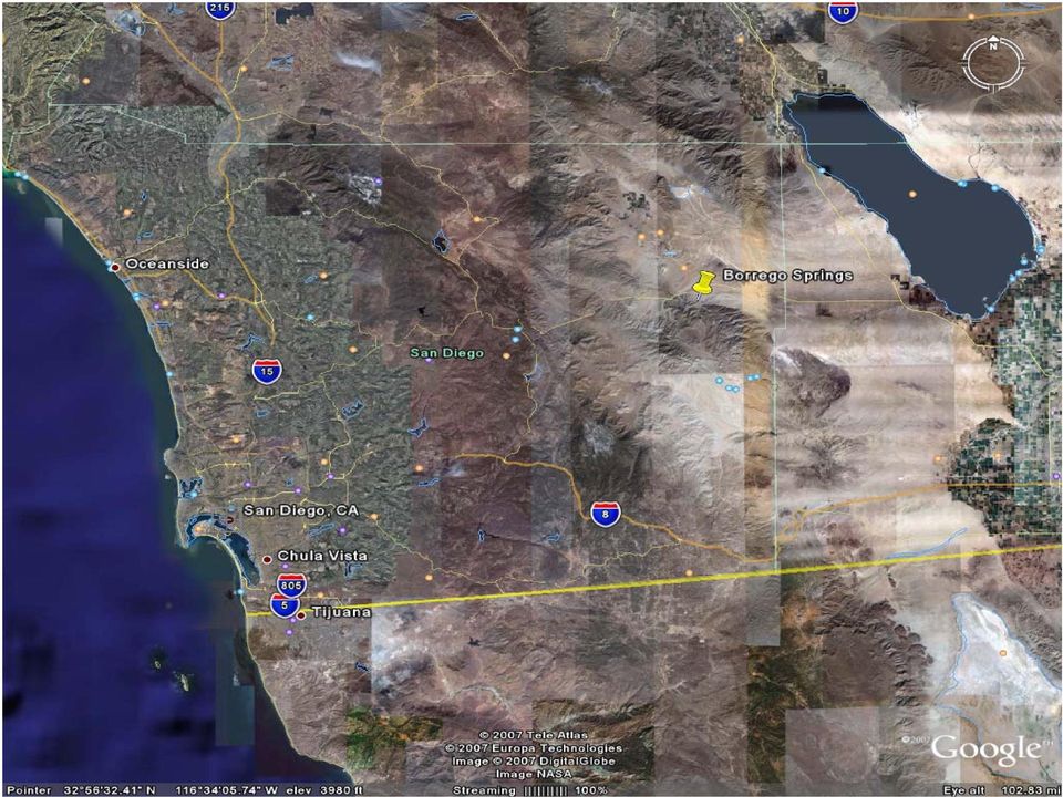
1 California Alluvial Fan Task Force County of San Diego Alluvial Fan Flooding and Risk Reduction Sara Agahi, PE, CFM January 4, 2008

2 Outline of Presentation Show location of San Diego County Alluvial Fan Area of Concern: Borrego Springs Illustrate Historical Flooding Events Describe County s Risk Reduction Efforts Regulatory Requirements Criteria for Alluvial Fan Development Summary

3
4

5 Looking southwest to de Anza Golf Club (notice Borrego Palm, Fire, and Hellhole Canyons). Looking southeast from Henderson Canyon to de Anza Golf Club.

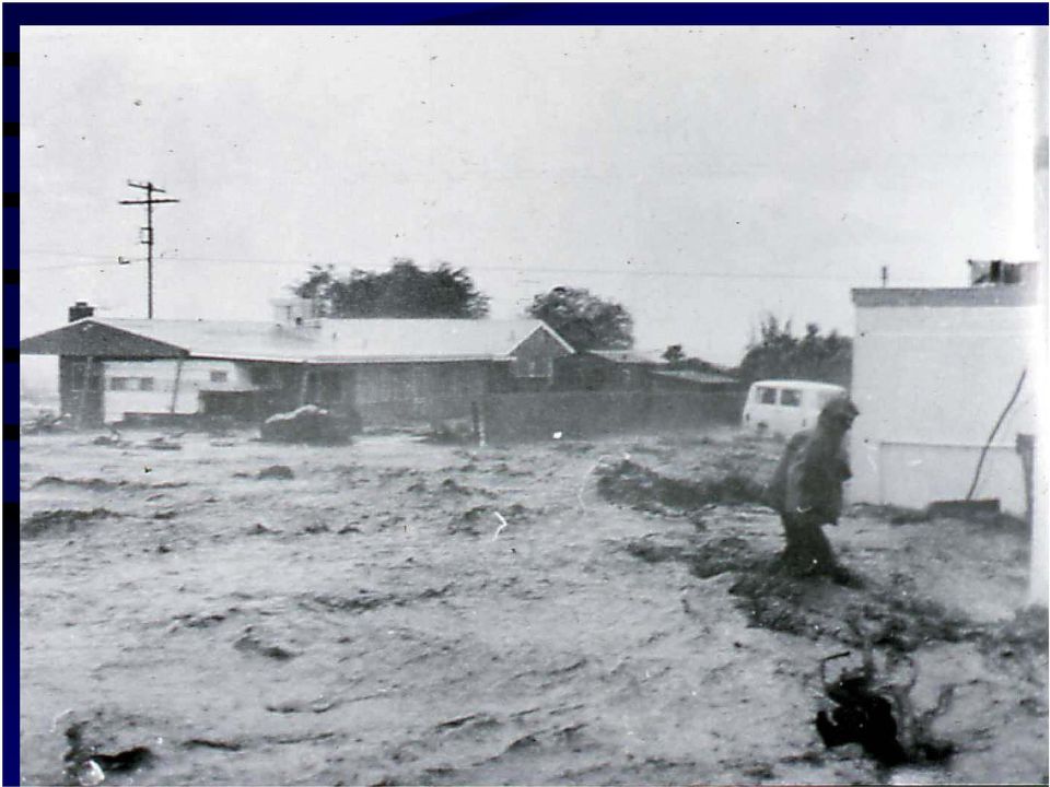
6 Borrego Palm Canyon 8/16/79 Average annual precipitation in Borrego: 3-6 Average annual precipitation along upstream ridgeline: up to 25 Flash Flood

7 Historical Flooding in Ocotillo, Hurricane Kathleen, 1976.

8
9 De Anza Flooding (view from apex of Borrego Palm Canyon)

10 Agua Caliente Airport (south of Borrego) and Agua Caliente Creek Example of sedimentation from alluvial fan flooding Agua Caliente Airport (south of Borrego) and Agua Caliente Creek

11 De Anza Golf Course flooding

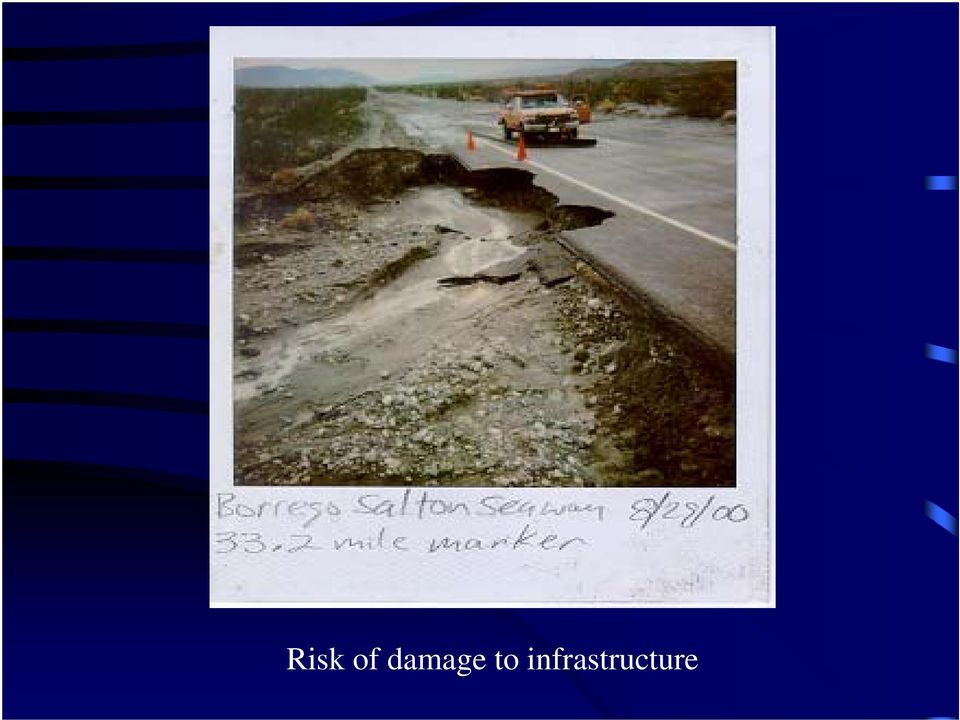
12 Risk of damage to infrastructure
13

14 Gabion fences located between Henderson and Borrego Palm Canyons. Divert flow from Borrego Palm Canyon. Examples of non-county risk reduction projects Built in 1960s or 70s. Who built these fences? Anyone maintaining them?

15 County of San Diego Efforts to Reduce Risk 1968, US Congress established National Flood Insurance Program (NFIP) administered by FEMA. July 1972, Board of Supervisors adopted General Plan for Flood Control Improvements, Borrego Valley, prepared by County Dept of Sanitation & Flood Control. December 1983, Board adopted County Flood Damage Prevention Ordinance #8334, Section , which establishes flood protection criteria for construction of structures in flood prone areas FEMA produces FIRMS for this area. July 1989, Board adopted Alluvial Fan Flood Management Report, Guidelines for non-structural Flood Protection and Flood Insurance Applications, prepared by DPW, created Borrego Valley Alluvial Fan Hazard Map. October 1989, Board accepted Boyle Engineering report, Borrego Valley Flood Management Report, which specifically deals with flood protection on alluvial fans in Borrego Springs.

16 Borrego Valley Alluvial Fan Flood Hazard Map Shows maximum expected flood depth and velocity Shows predicted risk to potential land owners

17 County of San Diego Guidelines for Risk Reduction for Structures in Borrego Springs Elevation Criteria Elevate lowest floor (including basement) above highest adjacent grade to at least as high as the number specified on the FIRM (Zone AO SFHA, sheet-type flow, high velocities). Elevate mechanical and utility equipment over depth of flooding. Open Space Criteria Maintain at least 50% of lot as open (unobstructed) space and provide adequate drainage paths around structures. Design Criteria Position structures perpendicular to fan flow so flood flows will not be diverted and damage other properties.
 space and provide adequate drainage paths around structures.")
18 Borrego Valley Flood Management Report also includes design guidance to help reduce risk for those who build on the alluvial fan.

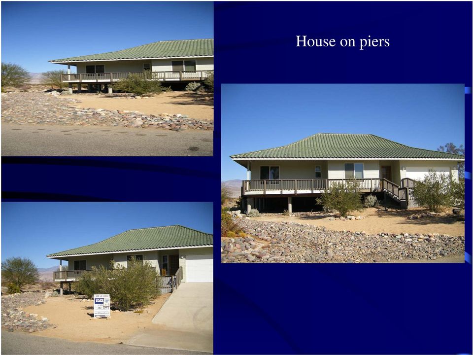
19 Examples of elevated houses (notice the open space on lots) Structures that incorporate risk reduction into their designs

20 House on piers
21 Flood wall
22 Summary History of extreme flood events in San Diego County alluvial fan areas. Demand to develop here because of lovely environment, pleasant climate, relatively cheap land prices. County committed to allowing legal development while protecting public safety.
23 Final Thought Even if your house is high and dry during a flood, consider: Roads Utilities Emergency Response Post flood clean up
24 Thank You Sara Agahi, PE, CFM Program Manager Watershed Protection Program County of San Diego (858)
25 Rams Hill Flood flows are intercepted upstream from development Channel at bottom of development redirects flow back to original alluvial fan Channels divert flow around development Requires dedicated channel maintenance funding source
And Flood Resilient Design in Austin, Texas
 And Flood Resilient Design in Austin, Texas The good, the bad and the ugly; What does this video show us? Riverine Flooding versus Flash Flooding Flash Flood Alley Stretches along the I 35 corridor between
DIVISION 11. [FLOOD DAMAGE PREVENTION]*
![DIVISION 11. [FLOOD DAMAGE PREVENTION]*](/thumbs/24/3469080.jpg "DIVISION 11. [FLOOD DAMAGE PREVENTION]*") Page 1 of 17 San Diego County Code of Regulatory Ordinances DIVISION 11. [FLOOD DAMAGE PREVENTION]* ---------- *Note--Added by Ord. No. 7534 (N.S.), effective 10-27-88, operative 9-27-88; chapters 1 through
Page 1 of 17 San Diego County Code of Regulatory Ordinances DIVISION 11. [FLOOD DAMAGE PREVENTION]* ---------- *Note--Added by Ord. No. 7534 (N.S.), effective 10-27-88, operative 9-27-88; chapters 1 through
FLOOD PROTECTION BENEFITS
 IV. (340 points) Flood Protection Benefits A. Existing and potential urban development in the floodplain (50) 1. Describe the existing and potential urban development at the site and the nature of the
A. Flood Management in Nevada
 Nevada Division of Water Planning A. Flood Management in Nevada Introduction Flooding has been a concern for Nevada communities since the first settlers moved to the territory in the mid-1800 s. Fourteen
Updated Federal Emergency Management Agency Flood Insurance Rate Maps and Zoning Ordinance Update. July 16, 2015 Policy Committee
 Updated Federal Emergency Management Agency Flood Insurance Rate Maps and Zoning Ordinance Update July 16, 2015 Policy Committee FEMA Map Update Costal Analysis and mapping study by FEMA in 2009 Changes
FEMA Flood Zone Designations
 Note: SFHA "Special Flood Hazard Area" FEMA Flood Zone Designations Zone VE Zone A Zone AE Zone X Zone X500 UNDES along coasts subject to inundation by the 100-year flood with additional hazards due to
COUNTy'OF SAN DIEGO DEPARTMENT OF PUBLIC WORKS LAND DEVELOPMENT DIVISION FLOOD CONTROL SECTION FLOOD CONTROL ON ALLUVIAL FANS MARCH, 1988
 --- --- - -- COUNTy'OF SAN DIEGO DEPARTMENT OF PUBLIC WORKS LAND DEVELOPMENT DIVISION FLOOD CONTROL SECTION FLOOD CONTROL ON ALLUVIAL FANS MARCH, 1988 05.002... - ----...--~. ---. ---~---:''''---.-~-':~----.-~.~.-"";'-''"'-~--:'---.-.-'--"=~~.---:':;":""~:::'"-~-~-
LOS ANGELES COUNTY S FLOODING HISTORY:
 LOS ANGELES COUNTY S FLOODING HISTORY: Since 1975, Los Angeles County has experienced twelve federally, declared flood disasters, with three of those disasters coming under El Niño conditions (1983, 1998,
FEMA s FLOOD INSURANCE RATE MAPS
 My Lender is requiring me to purchase Flood Insurance Options for San Diego County Residents in Unincorporated Areas This document is intended to help San Diego County residents who have been contacted
Frequently-Asked Questions about Floodplains and Flood Insurance FLOOD INSURANCE
 Frequently-Asked Questions about Floodplains and Flood Insurance What is a floodplain? The floodplain is any area covered by water during normal water flows, and which could be inundated as a result of
ORDINANCE NO. 618 BE IT ORDAINED AS FOLLOWS:
 ORDINANCE NO. 618 ORDINANCE OF THE MAYOR AND COUNCIL OF THE BOROUGH OF MANTOLOKING, OCEAN COUNTY, NEW JERSEY, PROVIDING FOR AMENDMENT OF ORDINANCE 525, FLOOD DAMAGE PREVENTION, AND REVISIONS OF CHAPTER
Saving Constituents Money on Flood Insurance Under FEMA s Community Rating System (CRS)
") Saving Constituents Money on Flood Insurance Under FEMA s Community Rating System (CRS) Today s Discussion 1. FEMA s Flood Insurance Program: A Brief Overview 2. Flood Insurance Rates: Are they rising?
Saving Constituents Money on Flood Insurance Under FEMA s Community Rating System (CRS) Today s Discussion 1. FEMA s Flood Insurance Program: A Brief Overview 2. Flood Insurance Rates: Are they rising?
Quick RefeRence Guide comparison of Select nfip and Building code Requirements for Special flood Hazard Areas
 Quick RefeRence Guide comparison of Select nfip and Building code Requirements for Special flood Hazard Areas This guide illustrates the similarities and highlights the differences between the National
Lincoln County Floodplain Development Permit Application
 Lincoln County Floodplain Development Permit Application Application # FP Use Permit Variance Appeal Date SECTION I: GENERAL PROVISIONS (APPLICANT to read and sign) 1. No work of any kind may start until
FEMA Updates Flood Plain Information For 2006
 Flood Insurance Rate Map Changes Informational Meeting For Property Owners Entering the Floodplain Durant Center February 23, 2011 Introductions City of Alexandria Transportation and Environmental Services
5.14 Floodplains and Drainage/Hydrology
 I-70 East Final EIS 5.14 Floodplains and Drainage/Hydrology 5.14 Floodplains and Drainage/Hydrology This section discusses floodplain and drainage/hydrology resources and explains why they are important
What We Do: Wetlands, Wildlife Habitat & Flood Hazards in the Root River Watershed
 What We Do: Wetlands, Wildlife Habitat & Flood Hazards in the Root River Watershed presented by Ceil Strauss, State Floodplain Manager DNR Ecological & Water Resources 1 EWR Roles In Floodplains Regulatory:
SECTION 19 RESIDENTIAL CONSTRUCTION IN FLOODZONES
 SECTION 19 RESIDENTIAL CONSTRUCTION IN FLOODZONES The purpose of the following information and documents are to clarify procedures used by the Sonoma County Permit & Resource Management Department to enforce
How To Build A Floodproofed Basement
 General Basement Exception Guidelines National Flood Insurance Program (NFIP) floodplain management criteria at 44 CFR 60.6 (c) provide for the granting of exceptions to permit construction of floodproofed
Draft Photo Documentation Update for Proposition 13 Grant Agreement No. San Diego Region McClellan-Palomar Airport Water Quality Treatment Facility
 Draft Photo Documentation Update for Proposition 13 Grant Agreement No. San Diego Region McClellan-Palomar Airport Water Quality Treatment Facility Prepared For: County of San Diego DPW 555 South Overland
 Using HAZUS for a Statewide Flood Risk Assessment Steve Cowdin, CA DWR Ken Leep, Cal EMA Problem We frequently receive requests for statewide flood data Who s at risk? What s at risk? Where is at risk?
Summary of Coastal Construction Requirements and Recommendations
 Summary of Coastal Construction Requirements and Recommendations HOME BUILDER S GUIDE TO COASTAL CONSTRUCTION FEMA 499/August 2005 Technical Fact Sheet No. 2 Purpose: To summarize National Flood Insurance
July 20, 2015. Subject: 7 th Avenue Creek Project Update & Elevation Certificates
 July 20, 2015 Subject: 7 th Avenue Creek Project Update & Elevation Certificates Below are a few updates regarding the 7 th Avenue Creek Project. As you may recall there are two concurrent and independent
SECTION 4.11 HYDROLOGY AND WATER QUALITY
 SECTION 4.11 HYDROLOGY AND WATER QUALITY This section describes federal, state and local regulations applicable to hydrology and water quality. It also describes the regional hydrologic setting, existing
Teller County, Colorado Floodplain Development Permit Application
 Teller County, Colorado Floodplain Development Permit Application This is an application packet for a Floodplain Development Permit (FDP). Certain sections are to be completed by the Applicant, and certain
Salt Lake County June 2010 Flooding and Restoration
 Salt Lake County June 2010 Flooding and Restoration Little Cottonwood (LCC) and Big Cottonwood (BCC) Kade Moncur, PE, CFM Salt Lake County Engineering August 10 th - 12 th SLCo Symposium 2011 August 10
Elevations Certificates: Update 2009 Presented by Wendy Lathrop, PLS, CFM
 Elevations Certificates: Update 2009 Presented by Wendy Lathrop, PLS, CFM The objectives of the National Flood Insurance Program (NFIP): Reduce the exposure to flood damages through the use of minimum
10-01. Technical Bulletin
 Technical Bulletin 10-01 Ensuring That Structures Built on Fill In or Near Special Flood Hazard Areas Are Reasonably Safe From Flooding in accordance with the National Flood Insurance Program FEDERAL EMERGENCY
Introduction to the National Flood Insurance Program: A Guide for Coastal Property Owners
 Introduction to the National Flood Insurance Program: A Guide for Coastal Property Owners Maine Beaches Conference 2015 Sue Baker, CFM State NFIP Coordinator sue.baker@maine.gov 207-287-8063 NFIP Goal:
rescue and relief efforts in the aftermath of flooding, (iii) repair of flood damaged public facilities and utilities, and
 repair of flood damaged public facilities and utilities, and") 1. Purpose (1) It is the purpose of this Ordinance to protect human life, health, and property from flood conditions, to preserve the ability of floodplains to carry and discharge a base flood, and to
1. Purpose (1) It is the purpose of this Ordinance to protect human life, health, and property from flood conditions, to preserve the ability of floodplains to carry and discharge a base flood, and to
CITY OF NORTHWEST FLOOD DAMAGE PREVENTION ORDINANCE. Non-Coastal Regular Phase
 CITY OF NORTHWEST FLOOD DAMAGE PREVENTION ORDINANCE Non-Coastal Regular Phase ARTICLE 1. STATUTORY AUTHORIZATION, FINDINGS OF FACT, PURPOSE AND OBJECTIVES. SECTION A. STTUTORY AUTHORIZATION. Municipal:
Openings in Foundation Walls for Buildings Located in Special Flood Hazard Areas
 Openings in Foundation Walls for Buildings Located in Special Flood Hazard Areas in accordance with the National Flood Insurance Program FEDERAL EMERGENCY MANAGEMENT AGENCY FEDERAL INSURANCE ADMINISTRATION
FEMA Elevation Certificate
 FEMA Elevation Certificate 2013 MARLS Conference Larry Schock, CFM DNRC Missoula Regional Office (406) 542-5885 lschock@mt.gov FEMA Elevation Certificate Presentation Overview National Flood Insurance
Federal Triangle Stormwater Working Group Federal Triangle Floodproofing Seminar BUILDING STRONG SM
 Federal Triangle Stormwater Working Group Federal Triangle Floodproofing Seminar Initial Risk Flood Risk = Probability of Flooding x Consequences Zoning Building Codes Outreach Evacuation Planning Risk
REBUILDING BELMAR ABFE FLOOD MAPS &THE REBUILDING PROCESS
 REBUILDING BELMAR ABFE FLOOD MAPS &THE REBUILDING PROCESS REBUILDING BELMAR ABFE Maps Preliminary FIRM Maps Flood Insurance Increased Cost of Compliance (ICC) Elevation of Structures Building Permits Acronyms
Post-Flood Assessment
 Page 1 of 7 Post-Flood Assessment CHAPTER 4 AGENCY COORDINATION Agency coordination is an essential element for the operation of the flood management systems in the Central Valley. Due to the nature of
CHAPTER 3 page 69 LOCAL FLOODPLAIN REGULATIONS AND NFIP STANDARDS
 CHAPTER 3 page 69 LOCAL FLOODPLAIN REGULATIONS AND NFIP STANDARDS LOCAL FLOODPLAIN REGULATIONS AND NFIP STANDARDS, page 69 THE PARTICIPATION OF A COMMUNITY IN THE NFIP IS MADE POSSIBLE BY ITS ADOPTION
Reducing Flood Risk to Residential Buildings That Cannot Be Elevated
 Reducing Flood Risk to Residential Buildings That Cannot Be Elevated FEMA P-1037 / September 2015 Elevated utility readable from standing height ~6.5' above grade Basement infill with gravel Approximate
In addition to the terms defined in this By-law, the following terms shall have the corresponding meanings for the purposes of this Section:
 Click here to access definitions SECTION 12 FLOODPLAIN LANDS 12.1 INTERPRETATION In addition to the terms defined in this By-law, the following terms shall have the corresponding meanings for the purposes
Wildfire & Flash Flood Recovery Emergency Watershed Protection (EWP) Flood Mitigation Efforts April 2014. Fall 2013
 Flood Mitigation Efforts April 2014. Fall 2013") Wildfire & Flash Flood Recovery Emergency Watershed Protection (EWP) Flood Mitigation Efforts April 2014 Fall 2013 Recovery Specific to Incident Recovery Efforts Depend on: Population Impacted Topography
Wildfire & Flash Flood Recovery Emergency Watershed Protection (EWP) Flood Mitigation Efforts April 2014 Fall 2013 Recovery Specific to Incident Recovery Efforts Depend on: Population Impacted Topography
OKANOGAN COUNTY OFFICE OF PLANNING AND DEVELOPMENT FLOODPLAIN DEVELOPMENT PERMIT APPLICATION
 OKANOGAN COUNTY OFFICE OF PLANNING AND DEVELOPMENT FLOODPLAIN DEVELOPMENT PERMIT APPLICATION Okanogan County Code, OCC 15.08, Floodplain Management The State of Washington has authorized county governments
Flooding & Elevation Certificates. Hurricane Floyd caused major Copyright flooding 2010 and - ASI damage to areas of Maryland
 Flooding & Elevation Certificates Hurricane Floyd caused major Copyright flooding 2010 and - ASI damage to areas of Maryland Floods Anywhere it rains, it can flood. A flood is a general and temporary condition
ARTICLE 12 FLOOD DAMAGE PREVENTION
 ARTICLE 12 FLOOD DAMAGE PREVENTION SECTION 12.1 AUTHORIZATION 12.1.1 General The Legislature of the State of North Carolina has in Part 6, Article 21 of Chapter 143; Parts 3 and 4 of Article 18 of Chapter
2012 Flood Hazard Prevention By Building and Planning Operations Manager Lou Ann Patellaro
 2012 Flood Hazard Prevention By Building and Planning Operations Manager Lou Ann Patellaro In 1968, Congress created the National Flood Insurance Program (NFIP) to provide affordable flood insurance to
CASS COUNTY COMMISSION POLICY MANUAL 38.07 ADOPTED DATE: FEBRUARY 2, 1998 PAGE 1 OF 9
 CASS COUNTY COMMISSION POLICY MANUAL 38.07 SUBJECT: ORDINANCE #1998-2 (FLOOD DAMAGE PREVENTION) ADOPTED DATE: FEBRUARY 2, 1998 PAGE 1 OF 9 NORTH DAKOTA COUNTY OF CASS ORDINANCE #1998-2 Be it ordained and
NATIONAL FLOOD INSURANCE PROGRAM (NFIP): THE BASICS & UPDATE
: THE BASICS & UPDATE") May 19, 2015 NATIONAL FLOOD INSURANCE PROGRAM (NFIP): THE BASICS & UPDATE ON THE CURRENT STATE Mary-Carson Stiff, JD, CFM Shannon Hulst Jarbeau, CFM Closing the Deal: How to respond to the new realities
May 19, 2015 NATIONAL FLOOD INSURANCE PROGRAM (NFIP): THE BASICS & UPDATE ON THE CURRENT STATE Mary-Carson Stiff, JD, CFM Shannon Hulst Jarbeau, CFM Closing the Deal: How to respond to the new realities
MT-EZ. Amendments to National Flood Insurance Program Maps. Application Form for Single Residential Structure Lot. FEMA Form 81-92 Series August 2004
 MT-EZ Amendments to National Flood Insurance Program Maps Application Form for Single Residential Structure Lot FEMA Form 81-92 Series August 2004 AMENDMENTS TO NATIONAL FLOOD INSURANCE PROGRAM MAPS APPLICATION
SECTION 1.0 STATUTORY AUTHORIZATION AND PURPOSE
 A local law for Flood Damage Prevention as authorized by the New York State Constitution, Article IX, Section 2, and Environmental Conservation Law, Article 36 1.1 FINDINGS SECTION 1.0 STATUTORY AUTHORIZATION
Presented by: Michael DePue, PE, CFM Annual Georgia Association of Floodplain Management Conference Lake Lanier Islands, Georgia March 23, 2010
 Flood Types and Characteristics Presented by: Michael DePue, PE, CFM Annual Georgia Association of Floodplain Management Conference Lake Lanier Islands, Georgia March 23, 2010 Agenda Why study flood types?
The answers to some of the following questions are separated into two major categories:
 Following the recent flooding events for Front Range communities in Colorado, property owners, communities, and the National Flood Insurance Program are being presented with some new challenges in the
Permit Application No. Development Address. Legal Description. A. Flood Plain and Floodway Information and Sources: (To be completed with Staff)
") FLOOD PLAIN DEVELOPMENT PERMIT APPLICATION of Olathe, Department of Public Works 1385 S. Robinson Drive P.O. Box 768 Olathe, Kansas 66051-0768 (913) 971-9045 FAX (913) 971-9099 Olathe, Kansas, Community
FLOOD PLAIN DEVELOPMENT PERMIT APPLICATION of Olathe, Department of Public Works 1385 S. Robinson Drive P.O. Box 768 Olathe, Kansas 66051-0768 (913) 971-9045 FAX (913) 971-9099 Olathe, Kansas, Community
OWNERS NAME PHONE OWNERS ADDRESS APPLICANTS NAME PHONE APPLICANTS ADDRESS
 TOWN OF SWANSBORO 502 Church Street, Swansboro, NC 28584 FLOODPLAIN DEVELOPMENT PERMIT OWNERS NAME PHONE OWNERS ADDRESS APPLICANTS NAME PHONE APPLICANTS ADDRESS Per Article 21, Section 21-7. Establishment
CHAPTER 152: FLOOD DAMAGE PREVENTION
 Page 1 of 18 Print Stephenville, TX Code of Ordinances CHAPTER 152: FLOOD DAMAGE PREVENTION Section Statutory Authorization, Findings of Fact, Purpose and Methods, Definitions 152.01 Statutory authorization
LOWEST FLOOR GUIDE I. LOWEST FLOOR DETERMINATION
 This section is to be used as a guide for identifying the lowest floor for rating buildings being considered for coverage under the National Flood Insurance Program. I. LOWEST FLOOR DETERMINATION The following
Permits for Development within Floodplains
 For More Information OKLAHOMA Oklahoma Water Resources Board 3800 N. Classen Boulevard Oklahoma City, OK 73118 (405) 530-8800 www.owrb.ok.gov Bulletin No. 2 FLOODPLAIN MANAGEMENT INFORMATION SERIES Lawton
FLOOD HAZARD MANAGEMENT SPECIFIC PLAN GUIDELINES
 INFORMATION BULLETIN / PUBLIC - BUILDING CODE REFERENCE NO.: L.A. Ordinance 172081 Effective: 01-01-2014 DOCUMENT NO.: P/BC 2014-064 Revised: Previously Issued As: P/BC 2011-064 FLOOD HAZARD MANAGEMENT
Division of Water Frequently asked floodplain questions
 Division of Water Frequently asked floodplain questions Q: Where can I find copies of the floodplain mapping? A: Local floodplain administrators will have copies of the FEMA mapping. (Generally the local
Floodplain Information
 Floodplain Information A large percentage of the Ellis community is located in the floodplain of Big Creek. The term floodplain means the low-lying areas on both sides of Big Creek that will be covered
DEPARTMENT OF PLANNING AND DEVELOPMENT
 DEPARTMENT OF PLANNING AND DEVELOPMENT FLOODPLAIN DEVELOPMENT PERMIT APPLICATION FOR NON-RESIDENTIAL DEVELOPMENT Property Owner Telephone Street/P.O. Box City State ZIP Agent (if any) Relationship to Property
Elevation Certificate Completion Guide
 Elevation Certificate Completion Guide General Comment: The latest FEMA Elevation Certificate form must be used. The form can be downloaded directly from the FEMA website (FEMA.gov). All information requested
Elevator Installation for Buildings Located in Special Flood Hazard Areas in accordance with the National Flood Insurance Program
 Elevator Installation for Buildings Located in Special Flood Hazard Areas in accordance with the National Flood Insurance Program FEDERAL EMERGENCY MANAGEMENT AGENCY FEDERAL INSURANCE ADMINISTRATION FIA-TB-4
Flood Emergency Response Planning: How to Protect Your Business from a Natural Disaster RIC005
 Flood Emergency Response Planning: How to Protect Your Business from a Natural Disaster RIC005 Speakers: Tom Chan, CEO, Global Risk Miyamoto Greg Bates, Principal, Global Risk Consultants Learning Objectives
EXISTING STRUCTURES 1) FAIR MARKET VALUE OF STRUCTURE(s) BEFORE IMPROVEMENT: 2) COST OF IMPROVEMENTS:
 FAIR MARKET VALUE OF STRUCTURE(s) BEFORE IMPROVEMENT: 2) COST OF IMPROVEMENTS:") Date Received: Received By: Project/Permit Number: Fee: (To be Completed by MOA) FLOOD HAZARD PERMIT APPLICATION (Please fill out application completely; Indicate NA if necessary. Property information
Date Received: Received By: Project/Permit Number: Fee: (To be Completed by MOA) FLOOD HAZARD PERMIT APPLICATION (Please fill out application completely; Indicate NA if necessary. Property information
ROSE CREEK WATERSHED HYDROLOGIC, HYDRAULIC, SEDIMENT TRANSPORT, AND GEOMORPHIC ANALYSES TASK 1 EXISTING DATA AND INFORMATION SUMMARY REPORT BACKGROUND
 ROSE CREEK WATERSHED HYDROLOGIC, HYDRAULIC, SEDIMENT TRANSPORT, AND GEOMORPHIC ANALYSES TASK 1 EXISTING DATA AND INFORMATION SUMMARY REPORT BACKGROUND The Rose Creek Watershed (RCW) consists of three planning
UNIT 5: THE NFIP FLOODPLAIN MANAGEMENT REQUIREMENTS
 UNIT 5: THE NFIP FLOODPLAIN MANAGEMENT REQUIREMENTS In this unit This unit reviews the NFIP standards for floodplain development, including: What maps, base flood elevations and other flood data must be
5.0 OVERVIEW OF FLOOD DAMAGE REDUCTION MEASURES
 5.0 OVERVIEW OF FLOOD DAMAGE REDUCTION MEASURES Flood damage reduction consists of two basic techniques structural and non-structural. Structural methods modify the flood and take the flood away from people
Mitigating Post-Fire Runoff from the Schultz Fire. ASCE/ASHE 2015 Annual State Conference
 Mitigating Post-Fire Runoff from the Schultz Fire ASCE/ASHE 2015 Annual State Conference Revisiting the Schultz Fire Burned ~15,000 acres (23.4 sm) in June/July 2010 2 Revisiting the Schultz Fire Burn
NFIP LOWEST FLOOR GUIDE ABRIDGED
 NFIP LOWEST FLOOR GUIDE ABRIDGED National Flood Insurance Program SCROLL DOWN 1 NFIP LOWEST FLOOR GUIDE QUICK REFERENCE This is an abridged version of the 2013 Flood Insurance Manual Lowest Floor Guide.
DEPARTMENT OF HOMELAND SECURITY FEDERAL EMERGENCY MANAGEMENT AGENCY STANDARD FLOOD HAZARD DETERMINATION FORM (SFHDF)
") Flood Determination The flood status of a property (and therefore the requirement for flood insurance) is based on whether a FEMA-designated Special Flood Hazard Area (100 year flood zone) touches a structure
Flood Determination The flood status of a property (and therefore the requirement for flood insurance) is based on whether a FEMA-designated Special Flood Hazard Area (100 year flood zone) touches a structure
Agenda. Presenter. The Current Form. Adobe Fillable Form. Elevation Certificates FEMA Form 81-31. Elevation Certificates Training 11/14/2013
 NORFMA Floodplain Conference November 14, 2013 Boise, Idaho Agenda Introductions & Housekeeping Overview Basics of FEMA Form 81-31 Building Diagrams Exercise Common Errors Using ECs in Floodplain Development
3.4 DRAINAGE PLAN. 3.4.1 Characteristics of Existing Drainages. 3.4.2 Master Drainage System. Section 3: Development Plan BUTTERFIELD SPECIFIC PLAN
 3.4 DRAINAGE PLAN This section describes the existing onsite drainage characteristics and improvements proposed within this Specific Plan. Following this description, drainage plan development standards
Building Olive s Flood Resiliency
 Building Olive s Flood Resiliency Informed Flood Mitigation Planning The Local Flood Analysis Flood Advisory Committee Meeting #1 Town of Olive s Community Room 4/14/15 What is an LFA? 1. Uses science
Flood Insurance Secrets That Most Agents Won t Tell You and Most People Don t Find Out Until It s Too Late!
 Flood Insurance Secrets That Most Agents Won t Tell You and Most People Don t Find Out Until It s Too Late! By Scott Kirby, Licensed Insurance Agent and Consumer Advocate In this report, you will discover
Overview of the National Flood Insurance Program (NFIP) and Recent Flood Mapping Efforts. Richard Zingarelli
 and Recent Flood Mapping Efforts. Richard Zingarelli") Overview of the National Flood Insurance Program (NFIP) and Recent Flood Mapping Efforts Richard Zingarelli State NFIP Program Coordinator Commonwealth of Massachusetts Department of Conservation and Recreation
Overview of the National Flood Insurance Program (NFIP) and Recent Flood Mapping Efforts Richard Zingarelli State NFIP Program Coordinator Commonwealth of Massachusetts Department of Conservation and Recreation
COMMUNITY CERTIFICATIONS
 National Flood Insurance Program Community Rating System COMMUNITY CERTIFICATIONS Public reporting burden for this form is estimated to average 4 hours for annual recertification, per response. The burden
Floodplain Development Land Use Review
 COMMUNITY DEVELOPMENT DEPARTMENT Planning Division P.O. Box 490 333 Broadalbin Street SW Albany, OR 97321 Phone 541-917-7550 Fax 541-791-0150 www.cityofalbany.net Floodplain Development Land Use Review
Flood Insurance Rating: Facts and Factors. Jana Green, CFM 2013 NJAFM Annual Conference October 17, 2013 Concurrent Session #3
 Flood Insurance Rating: Facts and Factors Jana Green, CFM 2013 NJAFM Annual Conference October 17, 2013 Concurrent Session #3 Purpose of Presentation THIS PRESENTATION IS INTENDED TO PROVIDE: A clear and
6.01 FEMA. 6.02 National Flood Insurance Program (NFIP)
") CHAPTER 6 FEMA AND FLOODPLAIN MANAGEMENT 6.01 FEMA The Federal Emergency Management Agency (FEMA) is an agency of the United States Department of Homeland Security. FEMA is tasked with responding to, planning
CHAPTER 6 FEMA AND FLOODPLAIN MANAGEMENT 6.01 FEMA The Federal Emergency Management Agency (FEMA) is an agency of the United States Department of Homeland Security. FEMA is tasked with responding to, planning
156. FLOOD DAMAGE PREVENTION
 156. FLOOD DAMAGE PREVENTION 156.01. STATUTORY AUTHORIZATION The Indiana Legislature has granted the power to local units of government (IC 36-1-3-1 et seq.) to control land use within their jurisdictions
2014 Delaware Ordinance Workshops and assistance. Higher Standards identified by Delaware Senate Bill 64
 INCREASING FLOOD RESILIENCY THROUGHT IMPROVED FLOOD CODES Michael S. Powell, Hazard Mitigation Program Manager, DNREC New Coastal Study and Floodplain Maps 2014 Delaware Ordinance Workshops and assistance
FREQUENTLY ASKED QUESTIONS
 FREQUENTLY ASKED QUESTIONS What factors determine flood insurance premiums? A number of factors determine premiums for National Flood Insurance Program (NFIP) insurance coverage. Major factors include
Flood Plain Management Permit Options For New Construction Homes
 Chapter Ordinances Governing FLOOD DAMAGE PREVENTION in the CITY OF ARLINGTON TEXAS Amended by Ordinance No. 10-011 (January 12, 2010) (Chapter Designator: FLOOD DAMAGE PREVENTION) FLOOD HAZARDS History
Flood Insurance Rate Maps
 Town of Kittery Maine Town Council Public Workshop Federal Emergency Management Agency Flood Insurance Rate Maps April 7, 2014 Federal Emergency Management Agency (FEMA) Manages response to national emergencies/disasters.
LOWEST FLOOR GUIDE I. LOWEST FLOOR DETERMINATION
 LOWEST FLOOR GUIDE This section is to be used as a guide for identifying the lowest floor for rating buildings being considered for coverage under the National Flood Insurance Program (NFIP). I. LOWEST
Relationship between Floodplain Management and Flood Insurance
 Relationship between Floodplain Management and Flood Insurance The National Flood Insurance Program [is] a voluntary program based on a mutual agreement between the Federal government and the local community:
MONTEZUMA COUNTY RESOLUTION _2-2014 FLOOD DAMAGE PREVENTION FLOOD DAMAGE PREVENTION
 MONTEZUMA COUNTY RESOLUTION _2-2014 FLOOD DAMAGE PREVENTION To amend Montezuma County Resolution 13-2008 FLOOD DAMAGE PREVENTION TABLE OF CONTENTS ARTICLE I - TITLE AND PURPOSE... 1 SECTION A. STATUTORY
FLOOD DAMAGE PREVENTION ORDINANCE
 FLOOD DAMAGE PREVENTION ORDINANCE WALLER COUNTY, TEXAS NFIP REGULATIONS 60.3 (d) Adopted January 13, 2009 Revised February 28, 2013 Effective February 28, 2013 Table of Contents ARTICLE I STATUTORY AUTHORIZATION,
Town of Hingham. Changes to Flood Insurance Rate Maps and Flood Insurance Costs Frequently Asked Questions
 Town of Hingham 1. What is a floodplain? Changes to Flood Insurance Rate Maps and Flood Insurance Costs Frequently Asked Questions A floodplain is an area of land where water collects, pools and flows
CITY OF PITTSBURGH Department of City Planning 200 Ross Street, Pittsburgh, PA 15219 412-255-2241 412-255-2561(fax)
") CITY OF PITTSBURGH Department of City Planning 200 Ross Street, Pittsburgh, PA 15219 412-255-2241 412-255-2561(fax) APPLICATION Construction and Development In the Flood Plain Overlay District This is
CITY OF PITTSBURGH Department of City Planning 200 Ross Street, Pittsburgh, PA 15219 412-255-2241 412-255-2561(fax) APPLICATION Construction and Development In the Flood Plain Overlay District This is
TITLE 8 FLOOD DAMAGE PREVENTION
 Henry County Development Code Flood Damage Prevention TITLE 8 FLOOD DAMAGE PREVENTION SECTION 1.0 FLOOD DAMAGE PREVENTION: STATUTORY AUTHORIZATION The Indiana Legislature granted the power to local units
Fiscal Year 2012 / 2013. San Diego County Flood Control District ANNUAL REPORT. Central Avenue, San Diego, California
 Fiscal Year 2012 / 2013 San Diego County Flood Control District ANNUAL REPORT Central Avenue, San Diego, California County of San Diego Department of Public Works FY 2012 / 2013 County of San Diego Flood
SECTION 15 FLOODPLAIN MANAGEMENT
 SECTION 15 15.1 Purpose Certain areas of the City of Gardiner, Maine, are subject to periodic flooding, causing serious damages to properties within these areas. Relief is available in the form of flood
Mission Creek Flood Control & Restoration Project. City of Fremont, Alameda County
 Mission Creek Flood Control & Restoration Project City of Fremont, Alameda County Agenda Background Why are proposed improvements necessary? Proposed project components Challenges Construction schedule/phasing
How To Manage A Flood
 Chapter 15.36 FLOOD DAMAGE PREVENTION* Sections: ARTICLE I. STATUTORY AUTHORIZATION, FINDINGS OF FACT, PURPOSE AND METHODS 15.36.010 Statutory authorization. 15.36.020 Findings of fact. 15.36.030 Statement
Floodplain Regulations for Maricopa County
 Floodplain Regulations for Maricopa County Published by: Flood Control District of Maricopa County 2801 West Durango Street, Phoenix, Arizona 85009 602-506-2419 FCDMC Amended June 25, 2014 (This page intentionally
Homeowner s Guide to Drainage
 Homeowner s Guide to Drainage a scottsdale homeowner s guide to drainage produced by the city of scottsdale s stormwater management division Transportation Department TABLE OF CONTENTS Introduction 2 Drainage
Elevation Certificates. Brad Loar FEMA Region IV
 Elevation Certificates Brad Loar FEMA Region IV What is the purpose of the Elevation Certificate? The Elevation Certificate is an important administrative tool of the National Flood Insurance Program (NFIP).
CHAPTER 152: FLOOD DAMAGE PREVENTION
 CHAPTER 152: FLOOD DAMAGE PREVENTION 00-15-152-01 Statutory Authority 00-15-152-02 Purpose 00-15-152-03 Definitions 00-15-152-04 Building Commissioner; Powers and Duties 00-15-152-05 Regulatory Flood Elevation
Please see Section IX. for Additional Information:
 The Florida Senate BILL ANALYSIS AND FISCAL IMPACT STATEMENT (This document is based on the provisions contained in the legislation as of the latest date listed below.) BILL: CS/SB 1094 Prepared By: The
FLOOD DAMAGE PREVENTION ORDINANCE ARTICLE I STATUTORY AUTHORIZATION, FINDINGS OF FACT, PURPOSE AND METHODS
 % ' ' 60.3(a) FLOOD DAMAGE PREVENTION ORDINANCE ARTICLE I STATUTORY AUTHORIZATION, FINDINGS OF FACT, PURPOSE AND METHODS SECTION A. STATUTORY AUTHORIZATION The Legislature of the State of Texas has in