Interim report of survey on soil degradation in National Forest Inventory by monitoring forest floor cover, through FAO Japan Fund Project.
|
|
|
- Domenic McLaughlin
- 8 years ago
- Views:
Transcription
1 Interim report of survey on soil degradation in National Forest Inventory by monitoring forest floor cover, through FAO Japan Fund Project. Jacinto Samuel García Carreón Ramón Cardoza Vázquez Soil Forest Division

2 Country profile 65% is arid and semiarid land, the coast are tropical and the mountains are temperate. Rangeland (bushland, savannahs, chaparrals, schrubland, grassland). Temperate Forest Tropical Perennial Forest Tropical Decidus Forest.
.")
3 Introduction How works water cycle in an undisturbed forest?

4 Importance of forest floor cover The understory, herbs, litter and duff, protect soil for the raindrop impact. The forest floor cover its more important than forest canopy cover for water quality, water infiltration and soil erosion process. Forest canopy cover it isn t a enough indicator for monitoring health forest and soil conservation process. Some studies in forest plantations in Chile, demonstrated that the forest floor cover, reduce soil erosion after forest harvest (without canopy).

5 Trust for Public Land and the American Water Works Association, 2002,

6 Goal Measure forest floor cover (percent and among), in some differents forest in México. Determine the best method by accuracy and cost-effective for measure forest floor cover. Try to take measures instead of estimate.

7 Methods, Sites and Materials We evaluate four methods, three methods for measure forest floor cover and one method for quantify understory and forest floor cover biomass. Expert Judment (Method 1) Photo Floor (Method 2) Densitometer (Method 4) Biomass quantify (Method 3)
 Photo Floor (Method 2) Densitometer")
8 Field Method s Method 3 Biomass Method 1 Expert Judgement Method 4 Densitometer Method 2 (Photo cover)


9 Expert Judgement (Method 1) Visual assessment of forest floor cover

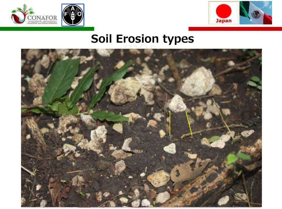
10 This method is used to determine protective functions and to take note of evidence of surface soil erosion. This method records: Forest floor cover Gullies Rills Pedestals Debris And other material to protect soil of raindrop splash, flowing, etc.

11 Soil Erosion types
.")
12 Photo Floor (Method 2) Forest canopy and forest structure assessment (canopy structure from the ground, lower 80 cm).
.")
13

14


15 Sample Point results

16 Method 4 (Densitometer) Line-point transect method of sampling

17 Method 3 Biomass quantity (dry matter)

18 Sample design 25 plots at 50m of long distance. Sampling total area is of hectars.

19 Sites Temperate forest (Pine) bushland Tropical deciduos forest Temperate forest (Abies) México City Crassulasian Srhubland Tropical perennial forest

20 Sites Temperate Tropical Arid Land Parameter Molinillos; Durango Estado de México Tomatlán, Jalisco Selva Lacandona Altiplano Potosino Tehuacán, Puebla Structure Trees, Shrub and herbs Trees, Shrub and herbs Trees, Shrub and herbs Trees, Shrub and herbs Shrubs (short), herbs Shrubs (tall), herbs Vegetation type Oak Pine Forest Oak Pine and douglas fir, Forest Tropical deciduos forest Tropical perennial forest Chaparral Shrubland Dominant species Pinus sp, Quercus sp. Pinus sp, Quercus sp., Abies sp. Cordia elaeagnoides, Enterolobium cyclocarpum Swietenia sp. Terminalia sp Larrea tridentata y Lophophora Williamsii Bursera sp., Acacia sp., Cactaceae family Canopy cover basal area m2/ha (not for specific site) Management Forest production management Conservation Rangeland Conservation Conservation Conservation Soils Feozems Andosoles Regosoles Ultisoles Calcisoles Regosoles
 10.25 36.91 18.69 3.")
21 Temperate Forest (Molinillos, Durango, México)
22 Centimetros C Climograma de El Salto, Estado de Durango Rainfall (cm) Rainfall plus storage moisture Evapotranspiration Temperature C ENE FEB MAR ABR MAY JUN JUL AGO SEP OCT NOV DIC Meses Dias humedos:
23 Temperate forest (humid) Villa Victoria, Estado de México, México.
24 Centimetros C Climograma de Villa Victoria, Estado de México Rainfall (cm) Evapotranspiration Rainfall plus storage moisture Temperature C ENE FEB MAR ABR MAY JUN JUL AGO SEP OCT NOV DIC Meses Dias humedos: 270 0
25 Tropical deciduos forest
26 Centimetros C Climograma de Tomatlán, Estado de Jalisco Rainfall (cm) Evapotranspiration Rainfall plus storage moisture Temperature C ENE FEB MAR ABR MAY JUN JUL AGO SEP OCT NOV DIC Meses Dias humedos: 60 0
27 Tropical perennial forest
28 Centimetros C Climograma de Chajul, Estado de Chiapas Rainfall (cm) Evapotranspiration Rainfall plus storage moisture Temperature C ENE FEB MAR ABR MAY JUN JUL AGO SEP OCT NOV DIC Meses Dias humedos: 240 0
29 Arid Vegetation (Larrea tridentata)
30 Centimetros C Climograma de Matehuala, S.L.P Rainfall (cm) Evapotranspiration Rainfall plus storage moisture Temperature C ENE FEB MAR ABR MAY JUN JUL AGO SEP OCT NOV DIC Meses Dias humedos: 0 0
31 Semiarid vegetation (Crassulasian plants)
32 Centimetros C Climograma de Zapotitlán de Salinas, Puebla Rainfall (cm) Evapotranspiration Rainfall plus storage moisture Temperature C ENE FEB MAR ABR MAY JUN JUL AGO SEP OCT NOV DIC Meses Dias humedos: 30 0
33 Materials
34 Results
35 Analysis of variance (Floor Cover Percent) The analysys of variance showed significative difference only on 3 of the 6 sites. The sites with significative difference between methods are: Real de Catorce, SLP (Chaparral, bushland, Larrea tridentata) Tomatlán, Jal. (Tropical deciduos forest) Zapotitlán, Pue. (Crassulasian Srhubland) In temperate forest and tropical perennials forest, the method are not significantly different, at α =0.05. It isn t posible to compare biomass method vs others, because it doesn t measure the same factor.
36 Forest floor cover % % of forest floor cover measure by differents methods Expert Judment (Method 1) Floor Photo (Method 2) Densitometer (Method 4) Temperate Forest Dgo. Temperate Forest EdoMex Tropical Perennial Forest Chis. Kind of forest Tropical Deciduos Forest Jal. Semiarid Land Pue. Arid Land S.L.P.
37 Analysis of variance (Cost) The analysis of variance showed significative difference in all methods. Expert judment and Densitometer are not significantly different, only in one site (Abies forest) are different. The cheapest method was Densitometer (Method 4), and the most expensive method was biomass.
38 Average cost (USD) Average cost (USD) for diferent method to evaluate forest soil cover Expert Judment Floor photo Biomass Densitometer Perennial Forest Temperate Fores (Pine) Temperate Fores (Abies) Tropical Deciduos Forest Crasulasian Srhubland (tall) Chaparral (bushland) Kind of forest
39 Total cost USD Average total cost per method Site Measures (only one plot) Transportation Expert Judgement Floor photo Biomass Densitometer Method
40 Total cost by Site USD Total cost by site Site Measures (only one plot) Transportation Perennial Forest 8.81 Temperate Fores (Pine) Temperate Fores (Abies) Kind of Forest Tropical Deciduos Forest Crasulasian Srhubland (tall) 8.70 Chaparral (bushland)
41 Conclusions The best methods to measure forest floor cover was Densitometer (Method 4) and Floor Photo (Method 2). The cheapest method was densitometer. Expert Judment is the most subjetive, and it depends too much for the people experience and criteria. The most expensive thing is the travel to arrive at the site, so we need to collect the most data as posible.
42 Recomendations We think that is good mixed the densitometer and photo floor method, and add biomass. Reduce de number of samples for the biomass method. Cuantify the litter layer width. Correlated the forest floor cover with measures variables in the Forest National Inventory
43 It s a good method for evaluate forest restauration process.
44 Next steps Mexico s National Forest Inventory, is going to measure forest floor cover and erosion evidence in about 6,000 sites. Mexico s National Forest Inventory, is going to take soil samples at different deep in about 1,000 sites.
45 Acknowledgements Japan Goverment, Forestry Agency, for found and advice the study. Food and Agriculture Organization, by select to Mexico, found and advice. Chapingo s University, for take to implement the methods. Colleagues from Mexico s National Forestry Agency, Soils Division.
46 Thanks
47
AT&T Global Network Client for Windows Product Support Matrix January 29, 2015
 AT&T Global Network Client for Windows Product Support Matrix January 29, 2015 Product Support Matrix Following is the Product Support Matrix for the AT&T Global Network Client. See the AT&T Global Network
Forest Watershed Tree Thinning Restoration Effectiveness Monitoring in the Manzano Mountains of New Mexico
 Forest Watershed Tree Thinning Restoration Effectiveness Monitoring in the Manzano Mountains of New Mexico By David Lightfoot 1,2, Cody Stropki 1, Victoria Amato 1 and Anne Russell 1 1 SWCA Environmental
THE ECOSYSTEM - Biomes
 Biomes The Ecosystem - Biomes Side 2 THE ECOSYSTEM - Biomes By the end of this topic you should be able to:- SYLLABUS STATEMENT ASSESSMENT STATEMENT CHECK NOTES 2.4 BIOMES 2.4.1 Define the term biome.
FOREST RESTORATION MONITORING TOOL
 FOREST RESTORATION MONITORING TOOL Draft version for field test INTRODUCTION FAO upon recommendation of its members identified the need to initiate a comprehensive analysis, evaluation and documentation
dynamic vegetation model to a semi-arid
 Application of a conceptual distributed dynamic vegetation model to a semi-arid basin, SE of Spain By: M. Pasquato, C. Medici and F. Francés Universidad Politécnica de Valencia - Spain Research Institute
COMPARISON OF FIXED & VARIABLE RATES (25 YEARS) CHARTERED BANK ADMINISTERED INTEREST RATES - PRIME BUSINESS*
 CHARTERED BANK ADMINISTERED INTEREST RATES - PRIME BUSINESS*") COMPARISON OF FIXED & VARIABLE RATES (25 YEARS) 2 Fixed Rates Variable Rates FIXED RATES OF THE PAST 25 YEARS AVERAGE RESIDENTIAL MORTGAGE LENDING RATE - 5 YEAR* (Per cent) Year Jan Feb Mar Apr May Jun
COMPARISON OF FIXED & VARIABLE RATES (25 YEARS) 2 Fixed Rates Variable Rates FIXED RATES OF THE PAST 25 YEARS AVERAGE RESIDENTIAL MORTGAGE LENDING RATE - 5 YEAR* (Per cent) Year Jan Feb Mar Apr May Jun
Communities, Biomes, and Ecosystems
 Communities, Biomes, and Ecosystems Before You Read Before you read the chapter, respond to these statements. 1. Write an A if you agree with the statement. 2. Write a D if you disagree with the statement.
The Feasibility of Chaparral Restoration on Type-converted Slopes MEGAN ENGEL KIMBERLYN WILLIAMS CHRISTOPHER MCDONALD JAN BEYERS
 The Feasibility of Chaparral Restoration on Type-converted Slopes MEGAN ENGEL KIMBERLYN WILLIAMS CHRISTOPHER MCDONALD JAN BEYERS Holtzclaw, Kenneth M., and Peggy Christian. San Timoteo Canyon. Charleston,
Estimation of Carbon Stock in Indian Forests. Subhash Ashutosh Joint Director Forest Survey of India sashutosh30@yahoo.com
 Estimation of Carbon Stock in Indian Forests Subhash Ashutosh Joint Director Forest Survey of India sashutosh30@yahoo.com Salient Features of the Methodology most comprehensive assessment so far a GIS
Increasing water availability through juniper control.
 Tim Deboodt, OSU Crook County Extension Agent 498 SE Lynn Blvd. Prineville, OR 97754 541-447-6228 Tim.deboodt@oregonstate.edu Increasing water availability through juniper control. Throughout the region
Table A1. To assess functional connectivity of Pacific marten (Martes caurina) we identified three stand types of interest (open,
 we identified three stand types of interest (open,") Supplemental Online Appendix Table A1. To assess functional connectivity of Pacific marten (Martes caurina) we identified three stand types of interest (open, simple, complex) but divided these into subclasses
Supplemental Online Appendix Table A1. To assess functional connectivity of Pacific marten (Martes caurina) we identified three stand types of interest (open, simple, complex) but divided these into subclasses
Summary of Pre- and Post-Project Vegetation Survey Results
 3921 East Bayshore Road Palo Alto CA 94303-4326 tel 650.962.9876 fax 650.962.8234 www.acterra.org info@acterra.org Introduction Summary of Pre- and Post-Project Vegetation Survey Results Acterra Stewardship
Assessment of cork production in new Quercus suber plantations under future climate. Joana A Paulo Margarida Tomé João HN Palma
 Assessment of cork production in new Quercus suber plantations under future climate Joana A Paulo Margarida Tomé João HN Palma 22 May 2012 1 Introduction Climate is related to several variables that affect
Developing environmental flow recommendations for a river with limited data: Rio Patuca, Honduras
 Developing environmental flow recommendations for a river with limited data: Rio Patuca, Honduras TOPICS 1. Goals 2. Area description 3. Problem definition 4. Activities 1. Hydrological analysis 2. Field
Keywords: soil and water conservation, yield increase, cost-benefit, watershed management, food security.
 20 years of watershed management in Niger: approaches, impacts and economic aspects of large scale soil and water conservation measures Nill, D.; Ackermann, K; Schöning, A.; Trux, A.; van den Akker, E.;
Need for up-to-date data to support inventory compilers in implementing IPCC methodologies to estimate emissions and removals for AFOLU Sector
 Task Force on National Greenhouse Gas Inventories Need for up-to-date data to support inventory compilers in implementing IPCC methodologies to estimate emissions and removals for AFOLU Sector Joint FAO-IPCC-IFAD
Section 5 CLIMATE TABLES
 Section Section CLIMATE SOURCES OF DATA... -1 HISTORICAL CONTEXT... -1 PRECIPITATION... -2 TEMPERATURES... -3 EVAPOTRANSPIRATION... -3 WIND SPEED AND DIRECTION... -4 DEGREE DAYS...-4 CONCLUSIONS AND RECOMMENDATIONS...
BIOENERGIA DE NUEVO LÉON, S.A. DE C.V.
 THE WORLD BANK MONTERREY S LANDFILL GAS TO ENERGY PROJECT BIOENERGIA DE NUEVO LÉON, S.A. DE C.V. Jorge Humberto Padilla Olvera & Jaime Luis Saldaña Méndez Washington, D.C., March 19 th, 2007 Waste type:
Deer Exclusion Effects on Understory Development Following Partial Cutting in a Pennsylvania Oak Stand
 Deer Exclusion Effects on Understory Development Following Partial Cutting in a Pennsylvania Oak Stand Larry H. McCormick 1/, John W. Groninger 2/, Kathy A. Penrod 1/, and Todd E. Ristau 1/ Abstract: Forty
Ranger Report About Tropical Rainforest (in Costa Rica)
") 1. Ranger Report About Tropical Rainforest (in Costa Rica) www. Therainforestrangers.com About Rainforest Images by Jan Dwire A rainforest is an environment that receives high rainfall and is dominated
1. Ranger Report About Tropical Rainforest (in Costa Rica) www. Therainforestrangers.com About Rainforest Images by Jan Dwire A rainforest is an environment that receives high rainfall and is dominated
Tropical Rainforest. Abiotic Factors Amount of Water, Sunlight, Soil, Precipitation
 World Biomes A biome is an area of land that shares similar temperatures and precipitation. The observation of the temperature and precipitation over a period time make up a biome s climate. Each biome
Table-2 : Inventory of archival tag in ICCAT data base
 Italy 02P0637 04-jun-03 BFT Levantine Sea (N Cyprus) Archival pop-up 02P0645 04-jun-03 BFT Levantine Sea (N Cyprus) Archival pop-up 02P0699 04-jun-03 BFT Levantine Sea (N Cyprus) Archival pop-up 03P0127
Case 2:08-cv-02463-ABC-E Document 1-4 Filed 04/15/2008 Page 1 of 138. Exhibit 8
 Case 2:08-cv-02463-ABC-E Document 1-4 Filed 04/15/2008 Page 1 of 138 Exhibit 8 Case 2:08-cv-02463-ABC-E Document 1-4 Filed 04/15/2008 Page 2 of 138 Domain Name: CELLULARVERISON.COM Updated Date: 12-dec-2007
Appendix C. Re-vegetation and Rehabilitation Sub-Plan
 Appendix C Re-vegetation and Rehabilitation Sub-Plan DRENNAN SOLAR ENERGY FACILITY REVEGETATION & REHABILITATION PLAN PRODUCED FOR ERM ON BEHALF OF SOLAIREDIRECT BY Simon.Todd@3foxes.co.za JUNE 2013 BACKGROUND
TURKMENISTAN. Akmurat t muradov
 TURKMENISTAN Akmurat t muradov General observations The independent and neutral State of Turkmenistan is situated in the western part of Central Asia, bordered by Kazakhstan, Uzbekistan, the Islamic Republic
GSB PROJECT. Latin American Vision The next 50 years SUSTAINABILITY: WATER USE, FERTILIZER, SOIL CARBON
 GSB PROJECT The Latin American Convention of the Global Sustainable Bioenergy Project 23 to 25 March 2010 Latin American Vision The next 50 years SUSTAINABILITY: WATER USE, FERTILIZER, SOIL CARBON Heitor
Monitoring of Forest Thinning Treatments and Wildfire Effects on Forest and Watershed Health in the Manzano Mountains, New Mexico
 Monitoring of Forest Thinning Treatments and Wildfire Effects on Forest and Watershed Health in the Manzano Mountains, New Mexico By David Lightfoot, Victoria Amato, and Cody Stropki SWCA Environmental
Life Cycle Of A Plant Population
 Life Cycle Of A Plant Population Seed Rain n=3 Growth And Mortality n=7 Seedling Cohort n=22 Environmental Sieve Seed Bank n=5 Copyright G. Bonan 22 Suvivorship Of Seedlings In A Northern Hardwood Forest
Analysis One Code Desc. Transaction Amount. Fiscal Period
 Analysis One Code Desc Transaction Amount Fiscal Period 57.63 Oct-12 12.13 Oct-12-38.90 Oct-12-773.00 Oct-12-800.00 Oct-12-187.00 Oct-12-82.00 Oct-12-82.00 Oct-12-110.00 Oct-12-1115.25 Oct-12-71.00 Oct-12-41.00
Create Your Own Soil Profile Ac5vity
 Create Your Own Soil Profile Ac5vity Middle School: 5-8 Task Overview: Soil profile refers to layers of soil. A typical soil profile takes nearly 1,000 to 100,000 years to form. The formation of the soil
CCX Forestry Carbon Offset Programs
 CCX Forestry Carbon Offset Programs Status of the U.S. Carbon Market A developing, voluntary market No national, regulatory greenhouse gas reduction scheme YET! Many local, state, and regional systems
CARBON BALANCE IN BIOMASS OF MAIN FOREST TREE SPECIES IN POLAND
 CARBON BALANCE IN BIOMASS OF MAIN FOREST TREE SPECIES IN POLAND PAWEŁ STRZELIŃSKI Department of Forest Management Poznan University of Life Science TOMASZ ZAWIŁA-NIEDŹWIECKI Forest Research Institute in
Enhanced Vessel Traffic Management System Booking Slots Available and Vessels Booked per Day From 12-JAN-2016 To 30-JUN-2017
 From -JAN- To -JUN- -JAN- VIRP Page Period Period Period -JAN- 8 -JAN- 8 9 -JAN- 8 8 -JAN- -JAN- -JAN- 8-JAN- 9-JAN- -JAN- -JAN- -JAN- -JAN- -JAN- -JAN- -JAN- -JAN- 8-JAN- 9-JAN- -JAN- -JAN- -FEB- : days
Soil and Vegetation Management: Keys to Water Conservation on Rangeland
 E-168 Soil and Vegetation Management: Keys to Water Conservation on Rangeland Joseph L. Schuster Professor and Extension Range Specialist Water is probably our least understood natural resource. The earth
Bringing Covert Land Use Strategies into the Spotlight: Cracking the Code for Sustainable Coastal Communities
 Bringing Covert Land Use Strategies into the Spotlight: Cracking the Code for Sustainable Coastal Communities Dan Hitchcock Baruch Institute, Clemson University, Georgetown, SC NEMO U 007 Portland, Maine
Forest Fire Information System (EFFIS): Rapid Damage Assessment
: Rapid Damage Assessment") Forest Fire Information System (EFFIS): Fire Danger D Rating Rapid Damage Assessment G. Amatulli, A. Camia, P. Barbosa, J. San-Miguel-Ayanz OUTLINE 1. Introduction: what is the JRC 2. What is EFFIS 3.
Forest Fire Information System (EFFIS): Fire Danger D Rating Rapid Damage Assessment G. Amatulli, A. Camia, P. Barbosa, J. San-Miguel-Ayanz OUTLINE 1. Introduction: what is the JRC 2. What is EFFIS 3.
TEA IN TURKEY Hamit Vanli
 TEA IN TURKEY Hamit Vanli Turkish State Tea Board (Caykur) Rize Turkey Global Advances in Tea Science, 1st May 1999. pp. 143 to 148 Edited by N.K.Jain, Published by Aravali Books International (P)Ltd,
The importance of ESD concept for rangeland monitoring program and rangeland management in Mongolia
 The importance of ESD concept for rangeland monitoring program and rangeland management in Mongolia Bulgamaa Densambuu, Green Gold, SDC Mongolia Bulgamaa@greengold.mn www.greengold.mn State of Mongolian
Uncertainty assessment of forest carbon balance. HMS seminaari 2.9 Vantaa
 Uncertainty assessment of forest carbon balance Research Team Finnish Forest Research Institute Raisa Mäkipää, Mikko Peltoniemi, Aleksi Lehtonen European Forest Institute (EFI) Taru Palosuo, Terhi Kaipainen
Restoration of Fire-adapted Ecosystems in the Central and Southern Appalachians
 Restoration of Fire-adapted Ecosystems in the Central and Southern Appalachians Marek Smith The Nature Conservancy 12181-A Courthouse Hill Road Warm Springs, VA 24484 marek_smith@tnc.org Sam Lindblom The
MASTER WORK PLAN FREQUENCY OR. City of Jefferson Sustainable Community Forest Master Plan
 ADMINISTRATION Adopt the Mayor and City Council Dec 2010 - - - - - - Retain an urban forestry or certified arborist consultant to coordinate the city's community forest management program City Manager
4.0 Discuss some effects of disturbances on the forest.
 4.0 Discuss some effects of disturbances on the forest. 4.1 Describe common disturbances that occur in the Boreal forest. Disturbances are normal to the life of the forest. Forests are very resilient (able
Blaine Hanson Department of Land, Air and Water Resources University of California, Davis
 Blaine Hanson Department of Land, Air and Water Resources University of California, Davis Irrigation Water Management - Science, Art, or Guess? Irrigation water management: questions to answer When should
Ecosystems. The two main ecosystem processes: Energy flow and Chemical cycling
 Ecosystems THE REALM OF ECOLOGY Biosphere An island ecosystem A desert spring ecosystem Biosphere Ecosystem Ecology: Interactions between the species in a given habitat and their physical environment.
CERTIFIED RANGELAND MANAGEMENT LICENSING ISSUES
 State of California Memorandum To : Eric K. Huff, RPF Executive Officer - Foresters Licensing Program Board of Forestry and Fire Protection Sacramento Department of Justice 1515 Clay Street, 20 th Floor
Range Management Databases on the Web: Two Examples
 Range Management Databases on the Web: Two Examples George Ruyle, Chair, Rangeland & Forest Research Program, School of Renewable Natural Resources, Biological Sciences East 302, University of Arizona,
How To Manage A Forest Service Plant Data On A Safari
 FIREMON Database User Manual John F. Caratti SUMMARY The FIREMON database software allows users to enter data, store, analyze, and summarize plot data, photos, and related documents. The FIREMON database
INTEGRATED IRRIGATION MANAGEMENT ON VITICULTURE
 INTEGRATED IRRIGATION MANAGEMENT ON VITICULTURE Posible evolución costes componentes 1 What is different in viticulture 2 3 4 Irrigation strategies Irrigation practices New technologies Posible evolución
SKY-TILE SKY-TILE. Daylight Consultants web: www.espaciosolar.com blog: espaciosolar.blogspot.com. Bioclimatic Modular Skylights
 DEPLOSUN DEPLOSUN is a modular glazing system that has a selective solar factor in relation with solar possition.this system is to be used in horizontal skylights. It is composed by a tempered T 6mm. glass
Work Report for Sino-Italian Cooperation Project (2005-2007) Application of Vallerani System Technology in Demonstration Forestation in Inner Mongolia
 Application of Vallerani System Technology in Demonstration Forestation in Inner Mongolia") Work Report for Sino-Italian Cooperation Project (2005-) Application of Vallerani System Technology in Demonstration Forestation in Inner Mongolia Key Technology for Mechanized Rain Collection and Vegetation
Work Report for Sino-Italian Cooperation Project (2005-) Application of Vallerani System Technology in Demonstration Forestation in Inner Mongolia Key Technology for Mechanized Rain Collection and Vegetation
The relationship between forest biodiversity, ecosystem resilience, and carbon storage
 The relationship between forest biodiversity, ecosystem resilience, and carbon storage Ian Thompson, Canadian Forest Service Brendan Mackey, Australian National University Alex Mosseler, Canadian Forest
Norwegian Forests. Policy and Resources
 Norwegian Forests Policy and Resources 21 Forestry in Norway Norway has long traditions in forestry and forest management, and for using wood in construction and as a source of energy. Sawn wood and round
Deciduous Forest. Courtesy of Wayne Herron and Cindy Brady, U.S. Department of Agriculture Forest Service
 Deciduous Forest INTRODUCTION Temperate deciduous forests are found in middle latitudes with temperate climates. Deciduous means that the trees in this forest change with the seasons. In fall, the leaves
How To Plan A Buffer Zone
 Backyard Buffers Protecting Habitat and Water Quality What is a buffer? A buffer (also called a riparian buffer area or zone) is the strip of natural vegetation along the bank of a stream, lake or other
Additional Criteria and Indicators for Cocoa Production
 Additional Criteria and Indicators for Cocoa Production November 2005 (SAN): Conservación y Desarrollo (CyD), Ecuador Fundación Interamericana de Investigación Tropical (FIIT), Guatemala Fundación Natura,
The Tropical Rainforest Rainforest Series, Part 1 - by Mikki Sadil
 Rainforest Series, Part 1 - Tropical rainforests are among the most mysterious of all geographical biomes in the world. A biome is an area with very distinctive plants and animals that have adapted to
Environmental impacts of harvesting biomass from the Nordic forests. Nicholas Clarke Norwegian Forest and Landscape Institute
 1 Environmental impacts of harvesting biomass from the Nordic forests Nicholas Clarke Norwegian Forest and Landscape Institute Background 2 Increased use of forest biomass for energy might lead to conflict
Point Boston Native Vegetation Management Plan 2014/15
 Point Boston Native Vegetation Management Plan 2014/15 Tom Angelos, Native Vegetation Portfolio Manager Point Boston Community Corp.25691 Inc. 1 Contents Pest Control Programme........2 Weed Control Programme......3
Cellulosic Feedstocks: Mitigating Risk and Cost Through a Portfolio Approach
 Cellulosic Feedstocks: Mitigating Risk and Cost Through a Portfolio Approach World Congress on Industrial Biotechnology April 20, 2016 Sam Jackson, VP Business Development Genera Energy Privately held
Threats to tropical forests
 Threats to tropical forests and what we can do about it Ryszard Laskowski Institute of Environmental Sciences Jagiellonian University www.eko.uj.edu.pl/laskowski 1/22 Human activities: dangers and hopes
Chapter 3 Communities, Biomes, and Ecosystems
 Communities, Biomes, and Ecosystems Section 1: Community Ecology Section 2: Terrestrial Biomes Section 3: Aquatic Ecosystems Click on a lesson name to select. 3.1 Community Ecology Communities A biological
Assume you have 40 acres of forestland that was
 A l a b a m a A & M a n d A u b u r n U n i v e r s i t i e s ANR-1371 Basal Area: A Measure Made for Management Assume you have 40 acres of forestland that was recently assessed by a natural resource
Ch. 15-Restoration Ecology
 Ch. 15-Restoration Ecology Conservation focuses on protecting and maintaining diversity and ecological processes Restoration emphasizes active management to bring back a former state of an ecosystem (
defined largely by regional variations in climate
 1 Physical Environment: Climate and Biomes EVPP 110 Lecture Instructor: Dr. Largen Fall 2003 2 Climate and Biomes Ecosystem concept physical and biological components of environment are considered as single,
Forest Management Plan Templates
 Forest Management Plan Templates The following templates as described in the Forestry Schemes Manual 2011 can be used in support of all scheme applications as described in the scheme documents 2014-2020
TERMS OF REFERENCE FOR THE RAPID EIA STUDY
 TERMS OF REFERENCE FOR THE RAPID EIA STUDY 1 SUMMARY OF EIA METHODOLOGY STEP I : SCOPING OF THE ASSESSMENT Own with prevailing regulatory setting and criteria Identification of Environmental Assessment
Jatropha World Asia 2011 June, 27 th - 28 th, 2011 Haikou, Hainan Island
 Jatropha World Asia 2011 June, 27 th - 28 th, 2011 Haikou, Hainan Island MINICIPALITIES INVOLVED WITH JATROPHA IN BRAZIL Planted Area: 50.000ha 2010 expansion: 10.000ha 201 municipalities JATROPHA TIMELINE
Ensuring Water Security for the sustainability of the Hani Rice Terraces, China against Climate and Land Use changes
 Rice Terrace Farming Systems Working Paper Series Number 2 June 215 Ensuring Water Security for the sustainability of the Hani Rice Terraces, China against Climate and Land Use changes Herath Srikantha
Mapping Forest-Fire Damage with Envisat
 Mapping Forest-Fire Damage with Envisat Mapping Forest-Fire Damage Federico González-Alonso, S. Merino-de-Miguel, S. García-Gigorro, A. Roldán-Zamarrón & J.M. Cuevas Remote Sensing Laboratory, INIA, Ministry
GIS Asia Link 2 : Course of Rehabilitation and Monitoring Degraded Forest In Southeast Asia
 Application of GIS for seed/planting zones and vegetation mapping Examples from Nepal and Kenya Jens-Peter Barnekow Lillesø Forest and Landscape Denmark Purpose of presentation: Suggest a tool for selection
POCKWOCK - BOWATER WATERSHED STUDY
 Contents Location of Study & Treatments..... 1 Site Characteristics.............. 2 Forest Composition.............. 3 Roads.... 3 Harvesting Information........... 4 Literature Cited.................
Key Words Forest Ecosystem, Carbon Dynamics, Boreal Forests, Tropical Forests, Plots Network
 1 - i Global Environment Research Account for National Institutes Advancement of East Asia Forest Dynamics Plots Network -Monitoring forest carbon cycling for the development of climate change adaptation-(abstract
Waterway Technote Planning
 Waterway Technote Planning Contents Benefits to planning your waterway management 1 Prioritising waterway management where to start? 1 What are your priorities? 1 Start with the best areas or those at
Inventory Enhancements
 Inventory Enhancements Chapter 6 - Vegetation Inventory Standards and Data Model Documents Resource Information Management Branch, Table of Contents 1. DETECTION OF CONIFEROUS UNDERSTOREY UNDER DECIDUOUS
National and Sub-national Carbon monitoring tools developed at the WHRC
 National and Sub-national Carbon monitoring tools developed at the WHRC Nadine Laporte Woods Hole Research Center A. Baccini, W. Walker, S. Goetz, M. Sun, J. Kellndorfer Kigali, 20 th June 2011 Why measuring
Tall Pots in a Shallow World
 Tall Pots in a Shallow World Scientists have figured out how to restore damaged urban desert landscapes with native plants that use less surface water and prevent erosion. Problem is, the scraggly little
TRADE REPORT. 1 JULY 2006 to 30 APRIL 2007
 TRADE REPORT 1 JULY 2006 to 30 APRIL 2007 Trade Highlights TRADE HIGHLIGHTS Trade through Sydney Ports this year continues to be the strongest on record. Total trade through all of Sydney s ports was 23.1
Managing Fire Dependent Wildlife Habitat without Fire. A Land Management Practice That: 100 Years of Fire Suppression in Ponderosa pine ecosystems
 Managing Fire Dependent Wildlife Habitat without Fire Dale Swedberg Chairman North Central Washington Prescribed Fire Council Land Management Practices used to Manage Wildlife Habitat A Land Management
6.4 Taigas and Tundras
 6.4 Taigas and Tundras In this section, you will learn about the largest and coldest biomes on Earth. The taiga is the largest land biome and the tundra is the coldest. The taiga The largest land biome
Chesapeake Bay Preservation Area (CBPA) in Virginia Beach, Virginia. The Resource Protection Area (RPA) and Buffers The First 100 Feet
 in Virginia Beach, Virginia. The Resource Protection Area (RPA) and Buffers The First 100 Feet") Chesapeake Bay Preservation Area (CBPA) in Virginia Beach, Virginia The Resource Protection Area (RPA) and Buffers The First 100 Feet How Large is the Chesapeake Bay Watershed? The Chesapeake Bay Watershed
Chesapeake Bay Preservation Area (CBPA) in Virginia Beach, Virginia The Resource Protection Area (RPA) and Buffers The First 100 Feet How Large is the Chesapeake Bay Watershed? The Chesapeake Bay Watershed
Forest Resources of the Gila National Forest
 United States Department of Agriculture Forest Service Rocky Mountain Research Station May 2008 Forest Resources of the Gila National Forest John D. Shaw New Mexico Gila National Forest About the author
PRESCRIBED GRAZING NATURAL RESOURCES CONSERVATION SERVICE CONSERVATION PRACTICE STANDARD. (Acre) Code 528
 Code 528") NATURAL RESOURCES CONSERVATION SERVICE CONSERVATION PRACTICE STANDARD PRESCRIBED GRAZING (Acre) Code 528 DEFINITION Managing the harvest of vegetation with grazing and/or browsing animals. PURPOSE Improve
NATURAL RESOURCES CONSERVATION SERVICE CONSERVATION PRACTICE STANDARD PRESCRIBED GRAZING (Acre) Code 528 DEFINITION Managing the harvest of vegetation with grazing and/or browsing animals. PURPOSE Improve
Wildfire Damage Assessment for the 2011 Southeast Complex Fires
 Wildfire Damage Assessment for the 2011 Southeast Complex Fires Chip Bates & Mark McClure, Forest Health Management Background: On March 24, 2011, multiple wildfires began across southeast Georgia. Strong,
Water Footprint Calculations for Pasture Based Beef Production
 Water Footprint Calculations for Pasture Based Beef Production Dr. Horst Jürgen Schwartz Professor (retired), Chair of Livestock Ecology Humboldt University of Berlin Faculty of Agriculture, Institute
Rainforest Activities By the Erie Zoo www.eriezoo.org
 What is Special about Rainforests? Rainforest Activities By the Erie Zoo www.eriezoo.org Objective: Students will work in teams to identify the importance of the rainforests to the world, people, and plants
A Developer s Guide: Watershed-Wise Development
 A Developer s Guide: Watershed-Wise Development Environmental Protection What is a watershed? It does not matter how far away you build from a creek, lake, or the ocean, you are in a watershed. Another
GLOBAL WOOD AND WOOD PRODUCTS FLOW
 ITEM 5 GLOBAL WOOD AND WOOD PRODUCTS FLOW TRENDS AND PERSPECTIVES Table of Contents GLOBAL WOOD AND WOOD PRODUCTS FLOW - TRENDS AND PERSPECTIVES... 1 SUMMARY... 2 INTRODUCTION... 3 INTERNATIONAL TRADE...
Assist. Prof. Dr. Melih ÖZTÜRK. E-mail: melihozturk@bartin.edu.tr. Web Site : www.bof.bartin.edu.tr. Phone : +90 378 223 51 28. Fax: +90 378 223 50 62
 Assist. Prof. Dr. Melih ÖZTÜRK Department of Landscape Architecture E-mail : melihozturk@bartin.edu.tr Web Site : www.bof.bartin.edu.tr Phone : +90 378 223 51 28 Fax: +90 378 223 50 62 Assist. Prof. Dr.
Power generation assets valuation adopting a real options approach applied to the Colombian electricity market
 Power generation assets valuation adopting a real options approach applied to the Colombian electricity market Simón Pérez-Arango Tutors: Gabriel Vizcaino-Sánchez (Celsia S.A.) Freddy Marín-Sánchez (EAFIT)
Seed Germination and Ecology of Western Australia
 Seed Ecology: Implications for Restoration of Native Vegetation in Australian Habitats Pat Johnson Introduction Native vegetation is disappearing over large areas of Australia due to a number of causes.
ERITREA: NAPA PROJECT PROFILE
 ERITREA: NAPA PROJECT PROFILE 1. Introducing community based pilot rangeland improvement and management in selected agro-ecological areas in the eastern and northwestern lowlands rangelands 2. Introducing
Natural Resources and Landscape Survey
 Landscape Info Property Name Address Information Contact Person Relationship to Landscape Email address Phone / Fax Website Address Landscape Type (private/muni/resort, etc.) Former Land Use (if known)
Forestry Department. Food and Agriculture Organization of the United Nations GLOBAL FOREST RESOURCES ASSESSMENT 2010 COUNTRY REPORT TURKEY
 Forestry Department Food and Agriculture Organization of the United Nations GLOBAL FOREST RESOURCES ASSESSMENT 2010 COUNTRY REPORT TURKEY FRA2010/214 Rome, 2010 The Forest Resources Assessment Programme
CAFIS REPORT 2015.10
 CAFIS REPORT 2015.10 INDEX Message CAFIS Inbound 03-06 07-08 CAFIS Arch 09-10 CAFIS Brain 11-12 CAFIS Global 13-14 What We Do 15-16 About CAFIS 17-18 Services for Member Stores 19-34 Services for Card
Forest landscape restoration SKS Focali meeting, Jönköping 11 jan 2013
 Forest landscape restoration SKS Focali meeting, Jönköping 11 jan 2013 Anders Malmer Theme leader at SLU Global for Restoration of degraded rural landscapes Theme leader for Focali for Climate assessed
Solar PV and Project Financing
 Solar PV and Project Financing Global Workshop on Grid Connected Renewable Energy USEA / USAid Washington, DC September 1 st 2009 January 2009 1 The Company Solarpack is a Solar Photovoltaic developer
Measuring and monitoring soil erosion for soil conservation and soil protection in Israel
 Measuring and monitoring soil erosion for soil conservation and soil protection in Israel Yoram Benyamini Ministry of Agriculture (SERS), Israel / University of Amsterdam, Netherlands benyamin@science.uva.nl
Use of remote sensing for crop yield and area estimates in Southern Brazil
 Use of remote sensing for crop yield and area estimates in Southern Brazil Denise Cybis Fontana Faculdade de Agronomia - UFRGS Remote Sensing support to crop yield forecast and area estimates 30 th November
Terrestrial Carbon Sequestration Monitoring Networks and Demonstration Sites
 Terrestrial Carbon Sequestration Monitoring Networks and Demonstration Sites Part II, Report to the Minnesota Department of Natural Resources From the Minnesota Terrestrial Carbon Sequestration Initiative