Canadian Geography Chapter 2 Beyond Your Space
|
|
|
- Belinda Hancock
- 7 years ago
- Views:
Transcription
1 Canadian Geography 1202 Chapter 2 Beyond Your Space 1

2 Canada 2
3 General Information 1. Canada has an area of 9, 970, 600 km squared. (second largest country in the world ) - there are 5514 km between easternmost (Cape Spear, NL.) and westernmost ( Beaver Creek, Yukon) points in Canada - the greatest distance north ( Alert in NWT ) to south ( Point Pelee in Ontario) is 4634 km. 3
4 Question Students complete question 1 on pg. 12! 4
5 2. Geographic Center This is the center point of the country measured from north to south and from east to west. It is Coats Island, Hudson Bay!!! 5
6 3. Effects of Canada s Size - Cost of transporting goods is high because of the distance (size), this affects the prices that consumers pay for goods. - Large areas are also hard to govern. 6

7 Question List three positive effects of Canada s size and three negative effects of our size??? 7
8 a. Positive effects of Canada s size: - more space to live - more agricultural land to grow crops - diverse landscape - diverse climate - large coastline with many fishing areas - many natural resources - great economic diversity 8
9 b. Negative effects of Canada s size: - high cost of building and maintaining highways, phone lines, pipelines etc, over long distances - high cost of cross country transportation and travel - large area to defend in the event of war - difficulty of communicating over long distances - six time zones 9
 Each province has it s own legislature while the territories are controlled by the federal government in Ottawa.")
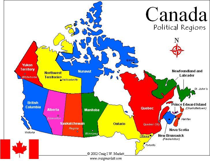
10 4. Dividing Canada In Canada, there are ten provinces and three territories. (Nunavut) Each province has it s own legislature while the territories are controlled by the federal government in Ottawa. - Political Map shows boundary lines between areas with different governments. 10
11 Political Boundary of Canada 11

12 5. Boundaries A. Natural boundary is a political boundary that follows physical features. Ex. mountains, rivers, lakes, seas or deserts. 12
13 B. Artificial Boundary is a political boundary that does not follow a natural feature. Many of these boundaries follow lines of latitude and longitude. 13
14 6. Regions Region is an area that shares certain features or characteristics. They are created through the physical landscape. It can separate people as mountains do or unite them like the seas do. 14

15 15
16 A. Single factor region - is a region based on a single characteristic, such as climate. B. Multi- factor region- is a region that is based on many different characteristics, such as climate, industry and language. 16

17 Question List the provinces and or territories that are located in Eastern Canada, Central Canada, Western Canada and Northern Canada!!! 17

18 7. A Regional Perspective A. Time Zones are a division of the earth s surface, usually extending across 15 degrees longitude, that establishes a uniform time. 18
19 Canadian Time Zones 19

20 B. Focal point- is the place from which people view their surroundings. C. Geographic Location is the map coordinates or spatial description of a place. 20

21 8. Latitude and Longitude A. the world is divided into four hemispheres Northern, Southern, Eastern and Western. 21


22 B. Line of Latitude is an imaginary horizontal line showing positions, measured in degrees, north and south of the equator. 22

23 C. Line of Longitude are imaginary vertical lines drawn between the poles showing positions, measured in degrees, minutes, and seconds, east and west from the Prime Meridian. 23
24 24


25 D. Equator is the o degrees line of latitude that circles the earth from west to east. 25
26 E. Prime Meridian is the 0 degrees line of longitude that circles the earth from north to south. 26
27 27
28 Questions Students do questions 12 a and b and 13 a and b on pg. 19. Also complete latitude and longitude handouts!!! 28
29 F. Lines of latitude and longitude are called co-ordinates. ( ex. 45 degrees N, 75 degrees W.) G. Gazetteer is an index found in an atlas, it lists countries, cities and physical features alphabetically. 29
 ( Each degree of latitude and longitude can be further")
30 H. Absolute Location is the exact location of a place or feature. ( Remember : degrees of latitude are 111km apart ) ( Each degree of latitude and longitude can be further divided into sixty minutes. Ex N. ) 30
31 i. Relative location this describes the general location of a place in relation to another physical feature or place. (ex. Next to the Avalon Mall when describing where Tom Woodford s car dealership is located) 31

32 9. Canada s Global Position A. Direction can be defined as movement in relation to the North Pole. B. Cardinal Points are the four main directions North, South, East and West. 32
33 C. Great Circle Route is a line drawn on the surface of a globe showing the shortest distance between two points. 33
34 10. Time and Space A. Time Zones a Canadian Sir Sanford Fleming developed the international time zones system. He divided the earth into 24 time zones, one for every 15 degrees of longitude which equals 360 degrees. Since then, time zone boundaries have been modified to make divisions more convenient. ( ex. Newfoundland) 34

35 World Time Zones 35
36 B. Greenwich Mean Time is the 0 degrees line of longitude. Time zones west of 0 degrees are successively one hour earlier, time zones east of 0 degrees are successively one hour later. 36
37 Greenwich Mean Time 37
38 C. International Date Line is the division line at 180 degrees longitude as one day ends and next begins. (Found in the Pacific Ocean ) ( changes one day ahead or one day back depending on the direction traveled) 38
39 International Date Line 39

40 Questions Students complete questions 20 and 21 on pg. 23!!!! 40

41 D. Time Distance is the time it takes to travel between two places.( Add up travel time for all modes of transportation used ) 41
42 Questions Have students complete time zone handouts!!! 42
Week 1. Week 2. Week 3
 Week 1 1. What US city has the largest population? 2. Where is Aachen? 3. What is the capitol of Florida? 4. What is the longest mountain range in Spain? 5. What countries border Equador? Week 2 1. What
World Map Lesson 4 - The Global Grid System - Grade 6+
 World Map Lesson 4 - The Global Grid System - Grade 6+ Activity Goal To use the global grid system of latitude and longitude to find specific locations on a world map. Materials Needed: A pencil, a ruler,
Grades 3-5. Benchmark A: Use map elements or coordinates to locate physical and human features of North America.
 Grades 3-5 Students use knowledge of geographic locations, patterns and processes to show the interrelationship between the physical environment and human activity, and to explain the interactions that
The Globe Latitudes and Longitudes
 INDIAN SCHOOL MUSCAT MIDDLE SECTION DEPARTMENT OF SOCIAL SCIENCE The Globe Latitudes and Longitudes NAME: CLASS VI SEC: ROLL NO: DATE:.04.2015 I NAME THE FOLLOWING: 1. A small spherical model of the Earth:
Stage 4. Geography. Blackline Masters. By Karen Devine
 1 Devine Educational Consultancy Services Stage 4 Geography Blackline Masters By Karen Devine Updated January 2010 2 This book is intended for the exclusive use in NSW Secondary Schools. It is meant to
Earth Coordinates & Grid Coordinate Systems
 Earth Coordinates & Grid Coordinate Systems How do we model the earth? Datums Datums mathematically describe the surface of the Earth. Accounts for mean sea level, topography, and gravity models. Projections
Lines on Maps and Globes. Cross Curricular Writing Activity Social Studies Grade 4
 Lines on Maps and Globes Cross Curricular Writing Activity Social Studies Grade 4 Fourth Grade Social Studies Standard Map: Chart/Globe The learner will be able to use maps, charts, graphs, and globes
UNIT I INTRODUCTION. This unit deals with Location space relations and India s place in the world
 UNIT I INTRODUCTION This unit deals with Location space relations and India s place in the world CHAPTER INDIA LOCATION You have already seen the map of India in the previous classes. Now you closely examine
Solar Angles and Latitude
 Solar Angles and Latitude Objectives The student will understand that the sun is not directly overhead at noon in most latitudes. The student will research and discover the latitude ir classroom and calculate
6 th Grade Vocabulary-ALL CAMPUSES
 6 th Grade Vocabulary-ALL CAMPUSES 6.1 History. The student understands that historical events influence contemporary events. (B) analyze the historical background of the United States to evaluate relationships
Allows teachers to print reports for individual students or an entire class.
 Map and Globe Skills Developed by teachers and geography specialists, Map and Globe Skills provides the strategies, skills and practice your students need to develop a strong understanding of basic mapping
Send all inquiries to: Glencoe/McGraw-Hill 8787 Orion Place Columbus, Ohio 43240-4027 ISBN 0-07-824996-1. Printed in the United States of America
 Copyright by The McGraw-Hill Companies, Inc. All rights reserved. Permission is granted to reproduce the material contained herein on the condition that such material be reproduced only for classroom use;
Sun Earth Relationships
 1 ESCI-61 Introduction to Photovoltaic Technology Sun Earth Relationships Ridha Hamidi, Ph.D. Spring (sun aims directly at equator) Winter (northern hemisphere tilts away from sun) 23.5 2 Solar radiation
How do you find a place on a globe? How do you look up a place based on latitude and longitude?
 Why are globes tilted? Most Replogle globes are made to tilt at an angle of 23.5º to match the actual tilt of the earth in relationship to our sun. Incidentally, it is this tilting of the earth relative
OBJECTIVES. Identify the means by which latitude and longitude were created and the science upon which they are based.
 Name: Key OBJECTIVES Correctly define: isolines, gradient, topographic map, contour interval, hachured lines, profile, latitude, longitude, hydrosphere, lithosphere, atmosphere, elevation, model EARTH
Celestial Observations
 Celestial Observations Earth experiences two basic motions: Rotation West-to-East spinning of Earth on its axis (v rot = 1770 km/hr) (v rot Revolution orbit of Earth around the Sun (v orb = 108,000 km/hr)
SOUTH AMERICA CONTENTS. What s in This Book... 2. Section 1: South America in the World... 3. Section 2: Political Divisions of South America...
 SOUTH CONTENTS What s in This Book 2 Section 1: 3 Section 2: Political Divisions of 1 Section 3: Physical Features of 41 Section 4: Valuable Resources of 67 Section : n Culture 89 Section 6: Assessment
Module 11: The Cruise Ship Sector. Destination #3
 Module 11: The Cruise Ship Sector Destination #3 Cruise Destinations Welcome to your third destination. Use the following resource article to learn about the different oceans and time zones. Seen from
Satellite Pursuit: Tracking Marine Mammals
 : Tracking Marine Mammals Material adapted from: Monterey Bay Research Institute, EARTH: Satellite Tracking OPB NOVA Teachers: Ocean Animal Emergency Teach Engineering: Marine Animal Tracking Introduction:
Introduction to Geography
 High School Unit: 1 Lesson: 1 Suggested Duration: 3 days Introduction to Lesson Synopsis: The purpose of this lesson is to introduce students to geography and geography terminology, to teach students about
Coordinate Systems. Orbits and Rotation
 Coordinate Systems Orbits and Rotation Earth orbit. The earth s orbit around the sun is nearly circular but not quite. It s actually an ellipse whose average distance from the sun is one AU (150 million
Rural Settlement Patterns
 Rural Settlement Patterns A summary with pictures. Courtesy of Crescent School There are three types of rural settlement patterns that occurred where large numbers of people settled: the long lots of
Otázka: Canada. Jazyk: Angličtina. Přidal(a): Tomdog3 BASIC FACTS. Capital. o Ottawa. Official languages. o English. o French. Area = 9.970.
: Tomdog3 BASIC FACTS. Capital. o Ottawa. Official languages. o English. o French. Area = 9.970.") Otázka: Canada Jazyk: Angličtina Přidal(a): Tomdog3 BASIC FACTS Capital o Ottawa Official languages o English o French Area = 9.970.610 km 2 Largem cities o Montreal, Calgary o Toronto, Vancouver Metropolitan
Otázka: Canada Jazyk: Angličtina Přidal(a): Tomdog3 BASIC FACTS Capital o Ottawa Official languages o English o French Area = 9.970.610 km 2 Largem cities o Montreal, Calgary o Toronto, Vancouver Metropolitan
MAPS AND GLOBES: WHERE IN THE WORLD ARE WE?
 MAPS AND GLOBES: WHERE IN THE WORLD ARE WE? Grade Level: Kindergarten Presented by: Karen Davis and Tamara Young, Tate Elementary, Van Buren, AR Length of unit:5 lessons I. ABSTRACT A. This unit focuses
FIRST GRADE 1 WEEK LESSON PLANS AND ACTIVITIES
 FIRST GRADE 1 WEEK LESSON PLANS AND ACTIVITIES UNIVERSE CYCLE OVERVIEW OF FIRST GRADE UNIVERSE WEEK 1. PRE: Describing the Universe. LAB: Comparing and contrasting bodies that reflect light. POST: Exploring
Answer Keys to Unit Tests
 Reading Geography Series Answer Keys to Unit Tests Unit 1 The Five Themes of Geography Unit 2 Patterns in Physical Geography Unit 3 Natural Resources 7 Portage & Main Press Unit Test for The Five Themes
The Map Grid of Australia 1994 A Simplified Computational Manual
 The Map Grid of Australia 1994 A Simplified Computational Manual The Map Grid of Australia 1994 A Simplified Computational Manual 'What's the good of Mercator's North Poles and Equators, Tropics, Zones
Lines of Latitude and Longitude
 ED 5661 Mathematics & Navigation Teacher Institute Keith Johnson Lesson Plan Lines of Latitude and Longitude Lesson Overview: This lesson plan will introduce students to latitude and longitude along with
Geography at GISSV: An Introduction to the Curriculum
 Geography at GISSV: An Introduction to the Curriculum Classes Geography is taught for two hours per week in Grades 5-9. The only exception is in Grade 8, where class is taught for one hour per week for
IAntarcticaI. IArctic Ocean I. Where in the World? Arctic Ocean. Pacific Ocean. Pacific Ocean. Atlantic Ocean. North America.
 Name ------------------------------ Where in the World? Continents and s Arctic Pacific Pacific Atlantic.1.... 0" o ". North America South America Antarctica Arctic 261 Name Where in the World Continents
Latitude, Longitude, and Time Zones
 Latitude, Longitude, and Time Zones Typical Graph This is an example of a typical graph. It is made up of points that are connected by a line. Y axis Typical Graph Each point has two values: (4,7) An X
Ch.1. Name: Class: Date: Matching
 Name: Class: Date: Ch.1 Matching Match each item with the correct statement below. a. technology e. democracy b. diffusion f. extended family c. exports g. interdependence d. climate 1. goods sent to markets
6. Base your answer to the following question on the graph below, which shows the average monthly temperature of two cities A and B.
 1. Which single factor generally has the greatest effect on the climate of an area on the Earth's surface? 1) the distance from the Equator 2) the extent of vegetative cover 3) the degrees of longitude
Seasonal & Daily Temperatures. Seasons & Sun's Distance. Solstice & Equinox. Seasons & Solar Intensity
 Seasonal & Daily Temperatures Seasons & Sun's Distance The role of Earth's tilt, revolution, & rotation in causing spatial, seasonal, & daily temperature variations Please read Chapter 3 in Ahrens Figure
Unit One Study Guide
 Unit One Study Guide Terms BCE: Before the Common Era. Referring to the time before Christ s birth. CE: Common Era. Referring to the time after Christ s birth. BC: Before Christ. Referring to the time
Tropical Horticulture: Lecture 2
 Lecture 2 Theory of the Tropics Earth & Solar Geometry, Celestial Mechanics The geometrical relationship between the earth and sun is responsible for the earth s climates. The two principal movements of
The Basics of Navigation
 The Basics of Navigation Knowledge of map reading and the use of the compass is an indispensable skill of bushcraft. Without this skill, a walker is a passenger and mere follower on a trip. To become a
How Do Oceans Affect Weather and Climate?
 How Do Oceans Affect Weather and Climate? In Learning Set 2, you explored how water heats up more slowly than land and also cools off more slowly than land. Weather is caused by events in the atmosphere.
SECOND GRADE 1 WEEK LESSON PLANS AND ACTIVITIES
 SECOND GRADE 1 WEEK LESSON PLANS AND ACTIVITIES UNIVERSE CYCLE OVERVIEW OF SECOND GRADE UNIVERSE WEEK 1. PRE: Discovering stars. LAB: Analyzing the geometric pattern of constellations. POST: Exploring
Discovering World Geography WESTERN HEMISPHERE
 WESTERN HEMISPHERE Follow Lesson Correlations for Instructional strategies that encourage the development of critical thinking, problem solving and performance skills. Custom Book: Student Edition REFERENCE
Prentice Hall World Geography: Building a Global Perspective 2007
 Prentice Hall World Geography: Building a Global Perspective 2007 Grades 9-12 C O R R E L A T E D T O Louisiana Grade-Level Expectations for World Geography Grades 9-12 Geography The World in Spatial Terms
Inside Earth Chapter 3
 Name Hour Due Date Inside Earth Chapter Page 1 Volcanoes and Plate Tectonics Page 2 Volcanic Activity Page - Mapping Earthquakes and Volcanoes Page 4 Mapping Earthquakes and Volcanoes table Page 5 - Mapping
An Introduction to Coordinate Systems in South Africa
 An Introduction to Coordinate Systems in South Africa Centuries ago people believed that the earth was flat and notwithstanding that if this had been true it would have produced serious problems for mariners
USING MAPS AND GLOBES
 USING MAPS AND GLOBES Grade Level or Special Area: 4 th Grade Written by: Krystal Kroeker, Colorado Springs Charter Academy, Colorado Springs, CO Length of Unit: Five lessons (approximately one week (five
The following words and their definitions should be addressed before completion of the reading:
 Seasons Vocabulary: The following words and their definitions should be addressed before completion of the reading: sphere any round object that has a surface that is the same distance from its center
Stellarium a valuable resource for teaching astronomy in the classroom and beyond
 Stellarium 1 Stellarium a valuable resource for teaching astronomy in the classroom and beyond Stephen Hughes Department of Physical and Chemical Sciences, Queensland University of Technology, Gardens
2. The map below shows high-pressure and low-pressure weather systems in the United States.
 1. Which weather instrument has most improved the accuracy of weather forecasts over the past 40 years? 1) thermometer 3) weather satellite 2) sling psychrometer 4) weather balloon 6. Wind velocity is
4 The Rhumb Line and the Great Circle in Navigation
 4 The Rhumb Line and the Great Circle in Navigation 4.1 Details on Great Circles In fig. GN 4.1 two Great Circle/Rhumb Line cases are shown, one in each hemisphere. In each case the shorter distance between
ES 106 Laboratory # 3 INTRODUCTION TO OCEANOGRAPHY. Introduction The global ocean covers nearly 75% of Earth s surface and plays a vital role in
 ES 106 Laboratory # 3 INTRODUCTION TO OCEANOGRAPHY 3-1 Introduction The global ocean covers nearly 75% of Earth s surface and plays a vital role in the physical environment of Earth. For these reasons,
Fourth Grade Social Studies Content Standards and Objectives
 Fourth Grade Social Studies Content Standards and Objectives Standard 1: Citizenship characterize and good citizenship by building social networks of reciprocity and trustworthiness (Civic Dispositions).
Educator s Guide to Learning about Mexico Using Google Earth
 Educator s Guide to Learning about Mexico Using Google Earth Overview: Students will research the physical features of Mexico using Google Earth to learn about Mexico s oceans, gulfs, bays, lagoons, rivers,
Where in the World is the arctic?
 Where in the World is the arctic? Summary: Students map the arctic in relation to their home in order to learn the location and countries of the arctic. Grade Level: 3-4; 5-8; K-2 Time one class period.
Geography affects climate.
 KEY CONCEPT Climate is a long-term weather pattern. BEFORE, you learned The Sun s energy heats Earth s surface unevenly The atmosphere s temperature changes with altitude Oceans affect wind flow NOW, you
SOCIAL STUDIES Geography/United States History Grade 8 The Oregon Country
 Lesson Components: Benchmarks SOCIAL STUDIES Geography/United States History Grade 8 The Oregon Country G-1A-M2 G-1B-M1 G-1B-M2 G-1C-M7 G-1D-M1 G-1D-M2 C-1B-M4 C-1C-M1 E-1B-M7 H-1A-M1 H-1A-M2 H-1A-M3 interpreting
Name Period 4 th Six Weeks Notes 2015 Weather
 Name Period 4 th Six Weeks Notes 2015 Weather Radiation Convection Currents Winds Jet Streams Energy from the Sun reaches Earth as electromagnetic waves This energy fuels all life on Earth including the
Fantasy flight. Investigation 7. Understanding the Investigation
 Investigation 7 Fantasy flight You have won a dre trip around the world, providing you with 50 000 km of free air travel to four major cities. Unfortunately, there is a catch! You have to pay for your
Gray Whales on the Move
 Gray Whales on the Move Students trace the migration route of a gray whale and discover the gray whale s natural history. Subjects Science GRADE LEVEL Grades 6 8 TIME 60 minutes OBJECTIVES Students will
Southern AER Atmospheric Education Resource
 Southern AER Atmospheric Education Resource Vol. 9 No. 5 Spring 2003 Editor: Lauren Bell In this issue: g Climate Creations exploring mother nature s remote control for weather and Climate. g Crazy Climate
Motion & The Global Positioning System (GPS)
") Grade Level: K - 8 Subject: Motion Prep Time: < 10 minutes Duration: 30 minutes Objective: To learn how to analyze GPS data in order to track an object and derive its velocity from positions and times.
Grade Level: K - 8 Subject: Motion Prep Time: < 10 minutes Duration: 30 minutes Objective: To learn how to analyze GPS data in order to track an object and derive its velocity from positions and times.
Level Middle school grades 6-8, lesson adaptations provided for High School grades 9-12
 Title: Turkey via Five Themes of Geography Author: Robert Cowles and Julie Marek- Clark County School District- Las Vegas, Nevada- Charles Silvestri Junior High School and Anthony Saville Middle School
LEARNING THE LANDFORMS Grade Level: Third Presented by: Elizabeth Turcott, Endeavor Charter Academy, Springfield, Michigan Length of Unit: 14 lessons
 LEARNING THE LANDFORMS Grade Level: Third Presented by: Elizabeth Turcott, Endeavor Charter Academy, Springfield, Michigan Length of Unit: 14 lessons I. ABSTRACT This unit develops an understanding of
STANDARD 3.1 Greece & Rome. STANDARD 3.2 - Mali
 2008 Curriculum Framework Grade Three Social Studies Standards Condensed format created by SOLpass. www.solpass.org Key: red text highlights NEW (2008 revision) content; crossout indicates content cut
Newton s Law of Gravity
 Gravitational Potential Energy On Earth, depends on: object s mass (m) strength of gravity (g) distance object could potentially fall Gravitational Potential Energy In space, an object or gas cloud has
Data Collection and Reporting Tool Training Presentation
 Data Collection and Reporting Tool Training Presentation 1 Table of Contents Introduction to the tool: Slides 3-9 How to use the tool General Information: Slides 11-14 Country Coordinator: Slides 15-35
CLIMATE, WATER & LIVING PATTERNS THINGS
 CLIMATE, WATER & LIVING PATTERNS NAME THE SIX MAJOR CLIMATE REGIONS DESCRIBE EACH CLIMATE REGION TELL THE FIVE FACTORS THAT AFFECT CLIMATE EXPLAIN HOW THOSE FACTORS AFFECT CLIMATE DESCRIBE HOW CLIMATES
DOMINION LAND SURVEY. COMPOSED AND PRODUCED BY : Chris Rule. Permission is granted for use by acknowledging the author s name.
 COMPOSED AND PRODUCED BY : Chris Rule Permission is granted for use by acknowledging the author s name. The Dominion Land Survey System was initiated by the Canadian Government in 1869 for settlement purposes.
What Causes Climate? Use Target Reading Skills
 Climate and Climate Change Name Date Class Climate and Climate Change Guided Reading and Study What Causes Climate? This section describes factors that determine climate, or the average weather conditions
Climate Change: A Local Focus on a Global Issue Newfoundland and Labrador Curriculum Links 2010-2011
 Climate Change: A Local Focus on a Global Issue Newfoundland and Labrador Curriculum Links 2010-2011 HEALTH Kindergarten: Grade 1: Grade 2: Know that litter can spoil the environment. Grade 3: Grade 4:
Internet Connectivity Among Aboriginal Communities in Canada
 Internet Connectivity Among Aboriginal Communities in Canada Since its inception the Internet has been the fastest growing and most convenient means to access timely information on just about everything.
11A Plate Tectonics. What is plate tectonics? Setting up. Materials
 11A Plate Tectonics What is plate tectonics? Earth s crust plus the upper mantle forms the lithosphere. Earth s lithosphere is broken in a number of different pieces. How these pieces move and interact
BASICS OF PRECISION AGRICULTURE (PA)
") BASICS OF PRECISION AGRICULTURE (PA) specific production on particular place specific production, from foot to foot... Same sense: data collection and decision making for small pieces of the field. Particular
BASICS OF PRECISION AGRICULTURE (PA) specific production on particular place specific production, from foot to foot... Same sense: data collection and decision making for small pieces of the field. Particular
United States History/Geography Integrated Lesson Plan On the Move: The Importance of Naming
 Name: Jennifer Curtis School: San Jacinto College South Name: Mary Curtis School: Clear Brook HS District: Clear Creek ISD Description of Lesson: Class Time Required: 90 Minutes United States History/Geography
A Policy Respecting the Prohibition of Bulk Water Removal from Major River Basins in Nunavut
 Indian and Northern Affairs Canada Affaires indiennes et du Nord Canada A Policy Respecting the Prohibition of Bulk Water Removal from Major River Basins in Nunavut Published under the authority of the
Thompson/Ocean 420/Winter 2005 Tide Dynamics 1
 Thompson/Ocean 420/Winter 2005 Tide Dynamics 1 Tide Dynamics Dynamic Theory of Tides. In the equilibrium theory of tides, we assumed that the shape of the sea surface was always in equilibrium with the
6. The greatest atmospheric pressure occurs in the 1) troposphere 3) mesosphere 2) stratosphere 4) thermosphere
 troposphere 3) mesosphere 2) stratosphere 4) thermosphere") 1. The best evidence of the Earth's nearly spherical shape is obtained through telescopic observations of other planets photographs of the Earth from an orbiting satellite observations of the Sun's altitude
1. The best evidence of the Earth's nearly spherical shape is obtained through telescopic observations of other planets photographs of the Earth from an orbiting satellite observations of the Sun's altitude
Searching Land Records thru the BLM General Land Office Records.
 Searching Land Records thru the BLM General Land Office Records. Land Records can be an exciting addition to your family history search. The United States Government transferred ownership of land to millions
Navigation: Latitude and Longitude
 Sextants and Chronometers Help Sailors Find Their Position at Sea Latitude lines run horizontally across the globe and are used to measure distances north and south of the equator. Sailors used a sextant
Prentice Hall World Studies 2005, 8 Book Series Correlated to: Millard Public School District (Nebraska) Social Studies Standards (Grades 6-7)
 Social Studies Standards (Grades 6-7)") Millard Public School District (Nebraska) Social Studies Standards (Grades 6-7) Note: This is a sample correlation based on four available titles of the new 2005 series in development. Titles include:,
Millard Public School District (Nebraska) Social Studies Standards (Grades 6-7) Note: This is a sample correlation based on four available titles of the new 2005 series in development. Titles include:,
UTM: Universal Transverse Mercator Coordinate System
 Practical Cartographer s Reference #01 UTM: Universal Transverse Mercator Coordinate System 180 174w 168w 162w 156w 150w 144w 138w 132w 126w 120w 114w 108w 102w 96w 90w 84w 78w 72w 66w 60w 54w 48w 42w
SESSION 8: GEOGRAPHIC INFORMATION SYSTEMS AND MAP PROJECTIONS
 SESSION 8: GEOGRAPHIC INFORMATION SYSTEMS AND MAP PROJECTIONS KEY CONCEPTS: In this session we will look at: Geographic information systems and Map projections. Content that needs to be covered for examination
8.5 Comparing Canadian Climates (Lab)
") These 3 climate graphs and tables of data show average temperatures and precipitation for each month in Victoria, Winnipeg and Whitehorse: Figure 1.1 Month J F M A M J J A S O N D Year Precipitation 139
These 3 climate graphs and tables of data show average temperatures and precipitation for each month in Victoria, Winnipeg and Whitehorse: Figure 1.1 Month J F M A M J J A S O N D Year Precipitation 139
Exploring Our World with GIS Lesson Plans Engage
 Exploring Our World with GIS Lesson Plans Engage Title: Exploring Our Nation 20 minutes *Have students complete group work prior to going to the computer lab. 2.List of themes 3. Computer lab 4. Student
One Stop Shop For Educators. Grade Three
 Grade Three OUR DEMOCRATIC HERITAGE In third grade, students conclude their introduction to United States history by studying the origins of American democracy. The historical strand compares ancient Greek
Follow That Hurricane!
 Discover Your World With NOAA Follow That Hurricane! What You Will Do Devastating damage expected A most Track a hurricane on the same powerful hurricane with unprecedented type of chart used at the strength
Topographic Maps Practice Questions and Answers Revised October 2007
 Topographic Maps Practice Questions and Answers Revised October 2007 1. In the illustration shown below what navigational features are represented by A, B, and C? Note that A is a critical city in defining
Earth-Sun Relationships. The Reasons for the Seasons
 Earth-Sun Relationships The Reasons for the Seasons Solar Radiation The earth intercepts less than one two-billionth of the energy given off by the sun. However, the radiation is sufficient to provide
ACTIVITY 1 Hemispheres of the World
 Name Date Class CTIVITY 1 s of the World Directions: Use your textbook to answer the questions below. 1. What line of latitude is used to divide the earth into Northern and Southern s? 2. What line of
BASICS OF GEOGRAPHY A UNIT OF STUDY. Includes Two Videos... 1. WATER AND LANDFORMS 2. CLIMATE AND NATURAL RESOURCES.
 BASICS OF GEOGRAPHY A UNIT OF STUDY Includes Two Videos... 1. WATER AND LANDFORMS 2. CLIMATE AND NATURAL RESOURCES Teacher's Guide Video Produced by VIDEO DIALOG, INC. Teacher's Guide and Blackline Master
4.0 Health Expenditure in the Provinces and Territories
 4.0 Health Expenditure in the Provinces and Territories Health expenditure per capita varies among provinces/territories because of different age distributions. xii Population density and geography also
WE VE GOT THE WHOLE WORLD IN OUR HANDS: Geography Spatial Sense
 WE VE GOT THE WHOLE WORLD IN OUR HANDS: Geography Spatial Sense Grade Level: Written by: Length of Unit: Third Grade Wendy S. Hyndman, The Classical Academy, Colorado Springs, CO Doreen W. Jennings, Lincoln
compass Encyclopedic Entry
 This website would like to remind you: Your browser (Apple Safari 7) is out of date. Update your browser for more security, comfort and the best experience on this site. Encyclopedic Entry compass For
Henry Hudson by Kelly Hashway
 Before planes, people traveled by boat. And getting goods from one place to another took a long time, especially when ships had to sail around continents. In the early 1600s, European trading companies
Activity 1 Reading Universal Time Level 2 http://www.uni.edu/storm/activities/level2/index.shtml
 Activity 1 Reading Universal Time Level 2 http://www.uni.edu/storm/activities/level2/index.shtml National Science Education Standards: As a result of activities in grades 5-8, all students should develop
6.E.2.2 Plate Tectonics, Earthquakes and Volcanoes
 Name: Date: 1. The road shown below was suddenly broken by a natural event. 3. The convergence of two continental plates would produce Which natural event most likely caused the crack in the road? island
International Boundary Study. China Hong Kong Boundary
 International Boundary Study No. 13 April 13, 1962 China Hong Kong Boundary (Country Codes: CH-HK) The Geographer Office of the Geographer Bureau of Intelligence and Research INTERNATIONAL BOUNDARY STUDY
Activity 10 - Universal Time
 Activity 10 - Universal Time Teacher s Guide Scientists use the Universal Time reference to talk about data that is taken around the globe. Universal Time is the time kept in the time zone centered on
CANADIAN CITIZENSHIP STUDY QUESTIONS & ANSWERS for the City of Richmond, 2010
 CANADIAN CITIZENSHIP STUDY QUESTIONS & ANSWERS for the City of Richmond, 2010 Section 1: Questions about Canada Aboriginal Peoples 1. Who are the Aboriginal peoples in Canada? The Aboriginal peoples were
Survey and Mapping Activities in Vietnam *
 UNITED NATIONS E/CONF.100/CRP.1 ECONOMIC AND SOCIAL COUNCIL Eighteenth United Nations Regional Cartographic Conference for Asia and the Pacific Bangkok, 26-29 October 2009 Item 7(a) of the provisional
How To Understand Canada
 Škola: Gymnázium, Brno, Slovanské náměstí 7 Šablona: III/2 Inovace a zkvalitnění výuky prostřednictvím ICT Název projektu: Inovace výuky na GSN prostřednictvím ICT Číslo projektu: CZ.1.07/1.5.00/34.0940
Lecture 2. Map Projections and GIS Coordinate Systems. Tomislav Sapic GIS Technologist Faculty of Natural Resources Management Lakehead University
 Lecture 2 Map Projections and GIS Coordinate Systems Tomislav Sapic GIS Technologist Faculty of Natural Resources Management Lakehead University Map Projections Map projections are mathematical formulas