Synthetic Aperture Radar (SAR)
|
|
|
- George Lamb
- 7 years ago
- Views:
Transcription
 Ministry of Security")

1 Synthetic Aperture Radar (SAR) Ministry of Security and Public Administration National Disaster Management Institute
2 RADAR RAdio Detection And Ranging

3 RADAR An object-detection system that uses radio waves to determine the range, altitude, direction, or speed of objects It was developed by several nations before and during World War 2. The term RADAR itself was coined in 1940 by the United Navy
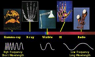
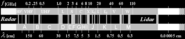
4 Wavelength
5 Passive vs. Active Satellite Passive satellite - reflect the incident electromagnetic radiation without any modification or amplification - It can not generate power they simply reflect the incident power - Optical satellites (Kompsat-2,3, Landsat, MODIS ) - Observation time: after sunrise until sunset - high spatial resolution Active satellite - Satellites which can transmit power - They can amplify or modify the incident signal for transmission - SAR satellites (Kompsat-5, ALOS-1, ENVISAT, TerraSAR-X) - Unlimited observation time - low spatial resolution - high expense
6 Synthetic Aperture Radar (SAR) SAR is a form of radar whose defining characteristic is its use of relative motion, between an antenna and its target region, to provide distinctive long-term coherent-signal variations, that are exploited to obtain finer spatial resolution that is possible with conventional beam-scanning means Frist citizen SAR satellite: SEASAT (1978, US) Resolution, Antenna length, high frequency, short wavelength Interferometry, Polarimetry: Phase Ragargrammetry: (Intensity)
7 Real vs. Synthetic
8 Real vs. Synthetic
9
10 TanDEM-X: TerraSAR-X add-on for Digital Elevation Measurement m COSMO-SkyMed : Constellation of small Satellites form the Mediterranean basin Observation
11 SRTM (Shuttle Radar Topography Mission, JPL, NASA) 60m mast 3 arc second data 90*90m, Global 1 arc second data 30*30, USA
12 Antenna type Radarsat-2 (15m*1.5m) TerraSAR-L (11m*2.9m) Pi-SAR2 (Airborne)
13 SAR observation mode Type of Mode 1. Spotlight 2. Stripmap 3. Scansar
14 SAR principle Side-looking system Difference between SAR and Optical imagery Radar reflection pattern
15 SAR distortion
16
17 Interferometry SAR imagery is recoded the pixel information by complex value Optical imagery is recoded the reflected power from ground object Complex Number intensity phase Radar reflection from Object Distance between senor and object
18 Interferometry flat topo defo atm noi Interferometric SAR is the interferometric phase flat is the flat earth phase topo is the topographic phase defo is the deformation phase atm is the atmospheric delay phase noi is the noise.
19 Interferometry
20 flat topo defo atm noi InSAR (IfSAR) : Interferometric Synthetic Aperture Radar DInSAR : Differential Interferometric Synthetic Aperture Radar PSI (PSInSAR) : Persistent Scatterer Interferometric SAR SqeeSAR SBSA (Small baseline) PolSAR : Polarimetric SAR
21 Different reflection due to wavelength
22 Signal reflection Smooth Specular Intermediate Specular and Diffuse Rough Diffuse
23 DEM generated by different band L-band elevation model X-band elevation model
24 Polarimetry
25 Polarimetric AIRSAR San francisco, USA
26 PSI (PSInSAR) Sydney, Australia Ground subsidence at underground mining area
27 SK image, Brisbane, Queensland, ustralia CSK image, Brisbane, Queensland, Australia
28 Flooding at Queensland, Australia Intensity image analysis
29 Flood at Queensland, Australia Coherence analysis and Vegetation analysis
30 Flood at Queensland, Australia CSK, Rockhampton, Queensland, Australia BBC international internet.
31 Flood Queensland, AU MODIS Aqua imagery
32 Flood in Germany MODIS Terra imagery
33 Flood map in Germany (Optical image)
34 Flood map in Czech Republic (RADARSAT-2)
35 Earthquake detection
36 Sichuan Earthquake, China, 2008 Christchurch Earthquake, NZ,2011
37 SAR Intensity image analysis China earthquake Barrier lake due to earthquake
38 DEM generation
39 Oil spill disaster ERS-1 data ENVISAT data X-,C-band (3, 5cm)
40 Oil spill disaster in Korea, 2007 ENVISAT ASAR, ESA
41 PSI result in Busan
42 Bushfire monitoring (Multispectral image)
Monitoring a Changing Environment with Synthetic Aperture Radar. Alaska Satellite Facility National Park Service Don Atwood
 Monitoring a Changing Environment with Synthetic Aperture Radar Don Atwood Alaska Satellite Facility 1 Entering the SAR Age 2 SAR Satellites RADARSAT-1 Launched 1995 by CSA 5.6 cm (C-Band) HH Polarization
Satellites for Terrain Motion Mapping Terrafirma User Workshop Mining. Nico Adam
 Satellites for Terrain Motion Mapping Terrafirma User Workshop Mining Nico Adam Outline SAR / InSAR observation characteristic Sensors TSX, TDX ERS-1, ERS-2 Processing techniques D-InSAR PSI SBAS Acquisition
Radar interferometric techniques and data validation Terrafirma Essen, March 2011. Page 1
 Radar interferometric techniques and data validation Terrafirma Essen, March 2011 Page 1 Agenda Introduction to InSAR technology Different radarinterferometric techniques Validation of InSAR technology
Active and Passive Microwave Remote Sensing
 Active and Passive Microwave Remote Sensing Passive remote sensing system record EMR that was reflected (e.g., blue, green, red, and near IR) or emitted (e.g., thermal IR) from the surface of the Earth.
POTENTIALS OF HIGH RESOLUTION TERRASAR-X IMAGES IN INSAR PROCESSING
 POTENTIALS OF HIGH RESOLUTION TERRASAR-X IMAGES IN INSAR PROCESSING FOR EARTH DEFORMATION AND ENVIRONMENTAL STUDIES Magdalena Niemiec 1 Abstract Accurate determination of topography and surface deformation
Exploitation of historical satellite SAR archives for mapping and monitoring landslides at regional and local scale
 Exploitation of historical satellite SAR archives for mapping and monitoring landslides at regional and local scale (A. Ferretti (TRE), A. Tamburini (TRE), M. Bianchi (TRE), M. Broccolato (Regione Valle
Professional SAR Data Processing
 Professional SAR Data Processing SAR Tutorial at EUSAR 2012 in Nürnberg (Germany) Dr. Thomas Bahr The information contained in this document pertains to software products and services that are subject
TerraSAR-X Applications Guide
 TerraSAR-X Applications Guide Extract: Maritime Monitoring: Oil Spill Detection April 2015 Airbus Defence and Space Geo-Intelligence Programme Line Maritime Monitoring: Oil Spill Detection Issue As the
The most widely used active remote sensing systems include:
 Active and Passive Remote Sensing Passive remote sensing systems record EMR that is reflected (e.g., blue, green, red, and near-infrared light) or emitted (e.g., thermal infrared energy) from the surface
Earth remote sensing systems of middle and low resolution
 Earth remote sensing systems of middle and low resolution Serial on-line remote sensing satellites delivering data available on the world market V.I. Gershenzon (ScanEx R&D Center) In 1980, graduated from
Remote Sensing an Introduction
 Remote Sensing an Introduction Seminar: Space is the Place Referenten: Anica Huck & Michael Schlund Remote Sensing means the observation of, or gathering information about, a target by a device separated
The European Space Agency s Synthetic Aperture Radar Programme From Experiment to Service Provision
 The European Space Agency s Synthetic Aperture Radar Programme From Experiment to Service Provision Evert Attema ESA, Directorate of Earth Observation Programme! The idea of an independent European space
Введение в спутниковую радиолокацию: Радиолокаторы с синтезированной апертурой (РСА) Introduction to satellite radars: Synthetic Aperture Radars (SAR)
 Introduction to satellite radars: Synthetic Aperture Radars (SAR)") Введение в спутниковую радиолокацию: Радиолокаторы с синтезированной апертурой (РСА) Introduction to satellite radars: Synthetic Aperture Radars (SAR) проф. Бертран Шапрон IFREMER / ЛСО РГГМУ Prof. Bertrand
Введение в спутниковую радиолокацию: Радиолокаторы с синтезированной апертурой (РСА) Introduction to satellite radars: Synthetic Aperture Radars (SAR) проф. Бертран Шапрон IFREMER / ЛСО РГГМУ Prof. Bertrand
How To Write A Call To Action For Terrasar-X
 Doc.: TX-PGS-PL-4127 TerraSAR-X Announcement of Opportunity: Utilization of the TerraSAR-X Archive 1 Page: 2 of 11 TABLE OF CONTENTS TERRASAR-X... 1 ANNOUNCEMENT OF OPPORTUNITY: UTILIZATION OF THE TERRASAR-X
Radar images Università di Pavia Fabio Dell Acqua Gruppo di Telerilevamento
 Radar images Radar images radar image DNs linked to backscattered field Backscattered field depends on wave-target interaction, with different factors relevant to it: within-pixel coherent combination
The use of Satellite Remote Sensing for Offshore Environmental Benchmarking
 The use of Satellite Remote Sensing for Offshore Environmental Benchmarking Michael King Fugro NPA Limited Fugro NPA (Formerly Nigel Press Associates) World leading Satellite Remote Sensing & Geoscience
Review for Introduction to Remote Sensing: Science Concepts and Technology
 Review for Introduction to Remote Sensing: Science Concepts and Technology Ann Johnson Associate Director ann@baremt.com Funded by National Science Foundation Advanced Technological Education program [DUE
SARscape 4.3 Supported Sensors/Products (March 2011) - Spaceborne Sensors -
 - Spaceborne Sensors -") SARscape 4.3 Supported Sensors/Products (March 2011) - Spaceborne Sensors - ALOS PALSAR (provided by JAXA) In case of RAW (level 1.0) data, import is carried out within the Focusing Module. PALSAR RAW
SARscape 4.3 Supported Sensors/Products (March 2011) - Spaceborne Sensors - ALOS PALSAR (provided by JAXA) In case of RAW (level 1.0) data, import is carried out within the Focusing Module. PALSAR RAW
Sentinel-1 Mission Overview
 Sentinel-1 Mission Overview Pierre Potin Sentinel-1 Mission Manager, ESA Advanced Course on Radar Polarimetry ESRIN, Frascati, 19 January 2011 Global Monitoring for Environment and Security GMES is established
Information Contents of High Resolution Satellite Images
 Information Contents of High Resolution Satellite Images H. Topan, G. Büyüksalih Zonguldak Karelmas University K. Jacobsen University of Hannover, Germany Keywords: satellite images, mapping, resolution,
TerraSAR-X Interferometry. Michael Eineder, Nico Adam Remote Sensing Technology Institute
 TerraSAR-X Interferometry Michael Eineder, Nico Adam Remote Sensing Technology Institute TerraSAR-X Contribution to Commissioning Phase: verify phase and geometric stability of instrument and SAR processor
PolSARpro v5.0. An ESA Educational, Free and Open Source Toolbox for Polarimetric SAR Data Analysis. Eric POTTIER
 PolSARpro v5.0 An ESA Educational, Free and Open Source Toolbox for Polarimetric SAR Data Analysis Eric POTTIER A Bit Of History CONTEXT The initiative development of PolSARpro Software is a direct result
Brian D. Conway Hydrologist/Supervisor Geophysics-Surveying Unit
 Arizona Department of Water Resources Land Subsidence Monitoring Program Using Interferometric Synthetic Aperture Radar (InSAR) in Cochise County, Southeastern Arizona Brian D. Conway Hydrologist/Supervisor
Chapter 1. Principles of Synthetic Aperture Radar
 Chapter 1. Principles of Synthetic Aperture Radar Samuel W. (Walt) McCandless, Jr. SEASAT Program Manager User Systems Enterprises, Inc., Denver, CO, USA Christopher R. Jackson Radar Imaging Resources,
GPS Precise Point Positioning as a Method to Evaluate Global TanDEM-X Digital Elevation Model
 GPS Precise Point Positioning as a Method to Evaluate Global TanDEM-X Digital Elevation Model 7 th FIG Regional Conference TS 1C Advances in GNSS Positioning and Applications I Volker Schwieger 1, Jürgen
Passive remote sensing systems record electromagnetic energy that was reflected (e.g., blue, green, red, and near-infrared light) or emitted (e.g.
 or emitted (e.g.") CHAPTER 9: Active and Passive Microwave RS REFERENCE: Remote Sensing of the Environment John R. Jensen (2007) Second Edition Pearson Prentice Hall Passive Remote Sensing Passive remote sensing systems
CHAPTER 9: Active and Passive Microwave RS REFERENCE: Remote Sensing of the Environment John R. Jensen (2007) Second Edition Pearson Prentice Hall Passive Remote Sensing Passive remote sensing systems
Istanbul Technical University-Center for Satellite Communications and Remote Sensing (ITU-CSCRS)
") Istanbul Technical University-Center for Satellite Communications and Remote Sensing (ITU-CSCRS) Istanbul Technical University, Center for Satellite Communications and Remote Sensing (ITU-CSCRS) was originally
Istanbul Technical University-Center for Satellite Communications and Remote Sensing (ITU-CSCRS) Istanbul Technical University, Center for Satellite Communications and Remote Sensing (ITU-CSCRS) was originally
Real Time Services for Space Applications Holger Maass, Susanne Lehner
 Real Time Services for Space Applications Holger Maass, Susanne Lehner Holger.Maass@dlr.de German Remote Sensing Data Center ( DFD ) with 2 locations in Germany Neustrelitz in Mecklenburg-Vorpommern Oberpfaffenhofen
Radar Interferometric and Polarimetric Possibilities for Determining Sea Ice Thickness
 Radar Interferometric and Polarimetric Possibilities for Determining Sea Ice Thickness by Scott Hensley, Ben Holt, Sermsak Jaruwatanadilok, Jeff Steward, Shadi Oveisgharan Delwyn Moller, Jim Reis, Andy
Satellite Altimetry Missions
 Satellite Altimetry Missions SINGAPORE SPACE SYMPOSIUM 30 TH SEPTEMBER 2015 AUTHORS: LUCA SIMONINI/ ERICK LANSARD/ JOSE M GONZALEZ www.thalesgroup.com Table of Content General Principles and Applications
ONE METER AND BELOW HIGH RESOLUTION SATELLITES IN PRODUCTION
 ONE METER AND BELOW HIGH RESOLUTION SATELLITES IN PRODUCTION A. Demirel, I. Bayir Inta Space Turk (Space Imaging Eurasia), Haymana Yolu 12.Km 06830 Golbasi Ankara, TURKEY (ibayir@spaceturk.com.tr, ademirel@spaceturk.com.tr)
Monitoring Soil Moisture from Space. Dr. Heather McNairn Science and Technology Branch Agriculture and Agri-Food Canada heather.mcnairn@agr.gc.
 Monitoring Soil Moisture from Space Dr. Heather McNairn Science and Technology Branch Agriculture and Agri-Food Canada heather.mcnairn@agr.gc.ca What is Remote Sensing? Scientists turn the raw data collected
Persistent Scatterer Interferometry and Cosmo-SkyMed data in the Piano Straordianario di Telerilevamento Ambientale (PST-A) Salvatore Costabile
 Salvatore Costabile") Persistent Scatterer Interferometry and Cosmo-SkyMed data in the Piano Straordianario di Telerilevamento Ambientale (PST-A) Salvatore Costabile E-GEOS Conference 2012 23-24 May, Rome (Italy) Summary PST-A:
Persistent Scatterer Interferometry and Cosmo-SkyMed data in the Piano Straordianario di Telerilevamento Ambientale (PST-A) Salvatore Costabile E-GEOS Conference 2012 23-24 May, Rome (Italy) Summary PST-A:
I.D.I.O.T.: A FREE AND EASY-TO-USE SOFTWARE TOOL FOR DINSAR ANALYSIS
 I.D.I.O.T.: A FREE AND EASY-TO-USE SOFTWARE TOOL FOR DINSAR ANALYSIS A. Reigber, E. Erten, S. Guillaso, and O. Hellwich Berlin University of Technology, Computer Vision and Remote Sensing Franklinstr.
Monitoring and characterizing natural hazards with satellite InSAR imagery
 Annals of GIS Vol. 16, No. 1, March 2010, 55 66 Monitoring and characterizing natural hazards with satellite InSAR imagery Zhong Lu a *, Jixian Zhang b, Yonghong Zhang b and Daniel Dzurisin a a US Geological
MONITORING MINING INDUCED GROUND-MOVEMENTS USING SAR INTERFEROMETRIC TECHNIQUES
 MONITORING MINING INDUCED GROUND-MOVEMENTS USING SAR INTERFEROMETRIC TECHNIQUES U. Wegmüller (1), T. Strozzi (1), N. Benecke (2), L. Petrat (11), M. Schlautmann (2), R. Kuchenbecker (2), J. Deutschmann
ROSA ESA - DLR Course 2009 RADAR REMOTE SENSING Day 4-5
 ROSA ESA - DLR Course 2009 RADAR REMOTE SENSING Day 4-5 Dr. Jan-Peter Mund, André Twele & Sandro Martinis German Remote Sensing Data Center (DFD) German Aerospace Center (DLR) RADAR REMOTE SENSING Introduction
Monitoring of Arctic Conditions from a Virtual Constellation of Synthetic Aperture Radar Satellites
 DISTRIBUTION STATEMENT A. Approved for public release; distribution is unlimited. Monitoring of Arctic Conditions from a Virtual Constellation of Synthetic Aperture Radar Satellites RSMAS Department of
Using advanced InSAR techniques as a remote tool for mine site monitoring
 The Southern African Institute of Mining and Metallurgy Slope Stability 2015 D. Colombo and B. MacDonald Using advanced InSAR techniques as a remote tool for mine site monitoring D. Colombo* and B. MacDonald
Deutsches Fernerkundungsdatenzentrum Nationales Bodensegment Neustrelitz. Holger Maass. Storagetechnology 2008 4.-6. Juni 2008, Fleesensee
 Deutsches Fernerkundungsdatenzentrum Nationales Bodensegment Neustrelitz Holger Maass Storagetechnology 2008 4.-6. Juni 2008, Fleesensee German Remote Sensing Data Center ( DFD ) with 2 locations in Germany
Software Architecture Document (SAD) for the Interferometric Modules of the Next ESA SAR Toolbox (NEST)
 for the Interferometric Modules of the Next ESA SAR Toolbox (NEST)") Software Architecture Document (SAD) for the Interferometric Modules of the Next ESA SAR Toolbox (NEST) Contract number: 20809/07/I-LG Prepared by: PPO.labs Prepared for: The European Space Agency Revision
Software Architecture Document (SAD) for the Interferometric Modules of the Next ESA SAR Toolbox (NEST) Contract number: 20809/07/I-LG Prepared by: PPO.labs Prepared for: The European Space Agency Revision
DIFFERENTIAL INSAR MONITORING OF THE LAMPUR SIDOARJO MUD VOLCANO (JAVA, INDONESIA) USING ALOS PALSAR IMAGERY
 USING ALOS PALSAR IMAGERY") DIFFERENTIAL INSAR MONITORING OF THE LAMPUR SIDOARJO MUD VOLCANO (JAVA, INDONESIA) USING ALOS PALSAR IMAGERY Adam Thomas (1), Rachel Holley (1), Richard Burren (1), Chris Meikle (2), David Shilston (2)
DIFFERENTIAL INSAR MONITORING OF THE LAMPUR SIDOARJO MUD VOLCANO (JAVA, INDONESIA) USING ALOS PALSAR IMAGERY Adam Thomas (1), Rachel Holley (1), Richard Burren (1), Chris Meikle (2), David Shilston (2)
The DLR Multi Mission EO Ground Segment
 The DLR Multi Mission EO Ground Segment Payload Ground Segment Erhard Diedrich Remote Sensing Workshop Mexico 22-24 April 2008 DLR Ground Segment for Earth Observation: Servicing GMES, national and commercial
High Resolution 3D Earth Observation Data Analysis for Safeguards Activities
 High Resolution 3D Earth Observation Data Analysis for Safeguards Activities Pablo d'angelo a1, Cristian Rossi a, Christian Minet a, Michael Eineder a, Michael Flory b, Irmgard Niemeyer c a German Aerospace
Image courtesy of the Canadian Center for Remote Sensing
 ADWR s Land Subsidence Monitoring Program Interferometric Synthetic Aperture Radar (InSAR) Brian D. Conway Hydrology Division Geophysics/Surveying Unit Image courtesy of the Canadian Center for Remote
Microwaves and Radar Institute
 Microwaves and Radar Institute Research and Projects Alberto Moreira German Aerospace Center DLR Oberpfaffenhofen, Germany Microwaves and Radar Institute 30+ years of experience in SAR systems and applications
Terrafirma Persistent Scatterer Processing Validation
 Terrafirma Persistent Scatterer Processing Validation Nico Adam (1), Alessandro Parizzi (1), Michael Eineder (1), Michele Crosetto () (1) Remote Sensing Technology Institute () Institute of Geomatics Signal
PI: Riccardo Lanari (IREA CNR) email:lanari.r@irea.cnr.it
 email:lanari.r@irea.cnr.it") On the exploitation and validation of COSMO-SkyMed interferometric SAR data for digital terrain modelling and surface deformation analysis in extensive urban areas (ID: 1441) Project partners: Istituto
On the exploitation and validation of COSMO-SkyMed interferometric SAR data for digital terrain modelling and surface deformation analysis in extensive urban areas (ID: 1441) Project partners: Istituto
COSMO-SkyMed: ¾Mission Definition ¾Main Application and Products
 COSMO-SkyMed: ¾Mission Definition ¾Main Application and Products Presented by: Laura Candela - ASI Francesco Caltagirone ASI UO EO Applications UO Payload RADAR Head COSMO-SkyMed System Manager Summary
TerraSAR-X Image Product Guide. Basic and Enhanced Radar Satellite Imagery. Airbus Defence and Space Geo-Intelligence Programme Line
 TerraSAR-X Image Product Guide Geo-Intelligence Programme Line 1 Introduction TerraSAR-X and TanDEM-X are commercial German Synthetic Aperture Radar (SAR) Earth observation satellites, which were launched
German Aerospace Center A member of the Helmholtz Association. Microwaves and Radar Institute. Digital- & Offsetdruck Wolfertstetter KG, Gilching
 Institute s Brochure Microwaves and Radar Institute Overview of Projects and Research Activities 1 German Aerospace Center A member of the Helmholtz Association Microwaves and Radar Institute Director
Two primary advantages of radars: all-weather and day /night imaging
 Lecture 0 Principles of active remote sensing: Radars. Objectives: 1. Radar basics. Main types of radars.. Basic antenna parameters. Required reading: G: 8.1, p.401-40 dditional/advanced reading: Online
Wide Area Persistent Scatterer Interferometry: Algorithms and Examples
 Wide Area Persistent Scatterer Interferometry: Algorithms and Examples Nico Adam, Fernando Rodriguez Gonzalez, Alessandro Parizzi, Werner Liebhart with contributions of Ramon Brcic and Xiao Ying Cong ca.
National Snow and Ice Data Center
 National Snow and Ice Data Center This data set (NSIDC-0484), part of the NASA Making Earth System Data Records for Use in Research Environments (MEaSUREs) Program, provides the first comprehensive, high-resolution,
The premier software for extracting information from geospatial imagery.
 Imagery Becomes Knowledge ENVI The premier software for extracting information from geospatial imagery. ENVI Imagery Becomes Knowledge Geospatial imagery is used more and more across industries because
Günter Seeber. Satellite Geodesy 2nd completely revised and extended edition
 Günter Seeber Satellite Geodesy 2nd completely revised and extended edition Walter de Gruyter Berlin New York 2003 Contents Preface Abbreviations vii xvii 1 Introduction 1 1.1 Subject of Satellite Geodesy...
Remote Sensing Satellite Information Sheets Geophysical Institute University of Alaska Fairbanks
 Remote Sensing Satellite Information Sheets Geophysical Institute University of Alaska Fairbanks ASTER Advanced Spaceborne Thermal Emission and Reflection Radiometer AVHRR Advanced Very High Resolution
Research on Soil Moisture and Evapotranspiration using Remote Sensing
 Research on Soil Moisture and Evapotranspiration using Remote Sensing Prof. dr. hab Katarzyna Dabrowska Zielinska Remote Sensing Center Institute of Geodesy and Cartography 00-950 Warszawa Jasna 2/4 Field
European Space Agency EO Missions. Ola Gråbak ESA Earth Observation Programmes Tromsø, 17 October 2012
 European Space Agency EO Missions Ola Gråbak ESA Earth Observation Programmes Tromsø, 17 October 2012 Europe and Space, A POLICY Article 189 of the Lisbon Treaty (2009) gives the European Union an explicit
Advantages and limitations of using satellite images for flood mapping
 Advantages and limitations of using satellite images for flood mapping Domenico Grandoni e-geos Headquarter Contrada Terlecchie 75100 Matera - Italy Commercial Office Via Cannizzaro 71 00156 Roma - Italy
REMOTE SENSING AND ENVIRONMENTAL MONITORING. P. M. Mather School of Geography, The University of Nottingham, U.K.
 REMOTE SENSING AND ENVIRONMENTAL MONITORING P. M. Mather School of Geography, The University of Nottingham, U.K. Keywords: Earth observation, image processing, lidar, pattern recognition, radar Contents
A remote sensing instrument collects information about an object or phenomenon within the
 Satellite Remote Sensing GE 4150- Natural Hazards Some slides taken from Ann Maclean: Introduction to Digital Image Processing Remote Sensing the art, science, and technology of obtaining reliable information
A review of the status of satellite remote sensing and image processing techniques for mapping natural hazards and disasters
 Progress in Physical Geography 33(2) (2009) pp. 183 207 A review of the status of satellite remote sensing and image processing techniques for mapping natural hazards and disasters Karen E. Joyce, 1 *
A tiered reconnaissance approach toward flood monitoring utilising multi-source radar and optical data
 5 th International Workshop on Remote Sensing for Disaster Response A tiered reconnaissance approach toward flood monitoring utilising multi-source radar and optical data Anneley McMillan Dr. Beverley
The use of Earth Observation technology to support the implementation of the Ramsar Convention
 Wetlands: water, life, and culture 8th Meeting of the Conference of the Contracting Parties to the Convention on Wetlands (Ramsar, Iran, 1971) Valencia, Spain, 18-26 November 2002 COP8 DOC. 35 Information
Multisensor Data Integration in O&G Business Lutz Petrat Hélène Lemonnier Michael Hall
 Multisensor Data in O&G Business Lutz Petrat Hélène Lemonnier Michael Hall ESA Oil and Gas Workshop 15/09/2010, Frascati, Italy Satellite Products and Services during a typical O&G project Project Life
Data Collection via Synthetic Aperture Radiometry towards Global System
 RESEARCH ARTICLE OPEN ACCESS Data Collection via Synthetic Aperture Radiometry towards Global System Ali. A. J.Al-Sabbagh**, Ruaa.A.S.Alsabah***, Josko.Zec*, Ivica Kostanic* *Department of Electrical and
Interferometric TOPS Chain Description
 www.dlr.de/hr > SEOM INSARAP INSARAP Workshop December 10, 2014 > Slide 1 SEOM INSARAP: Sentinel-1 InSAR Performance Study with TOPS Data ESA-ESRIN Contract 4000110587/14/I-BG Interferometric TOPS Chain
June 2011. TerraSAR-X-based Flood Mapping Service
 June 2011 TerraSAR-X-based Flood Mapping Service Service TerraSAR-X-based Flood Mapping Product Flood extent map Product specifications Flood mask / water mask Input / output data Summary Content Date
2.3 Spatial Resolution, Pixel Size, and Scale
 Section 2.3 Spatial Resolution, Pixel Size, and Scale Page 39 2.3 Spatial Resolution, Pixel Size, and Scale For some remote sensing instruments, the distance between the target being imaged and the platform,
COMPARISON OF SRTM AND 25K TOPOGRAPHIC MAPS IN TURKEY
 COMPARISON OF SRTM AND 25K TOPOGRAPHIC MAPS IN TURKEY Oztug Bildirici 1, Aydin Ustun, Necla Ulugtekin 2, H. Zahit Selvi 1, Alpay Abbak 1, Ilkay Bugdayci 1, A. Ozgur Dogru 2 1 Selcuk University, Faculty
German Earth Observation Systems and Programs Capacities for nation building
 German Earth Observation Systems and Programs Capacities for nation building German Aerospace Center, DLR, Earth Observation Center, EOC German Remote Sensing Data Center, DFD Gunter Schreier Deputy Director
Interferometric Synthetic Aperture Radar (SAR) Missions Employing Formation Flying
 Missions Employing Formation Flying") INVITED PAPER Interferometric Synthetic Aperture Radar (SAR) Missions Employing Formation Flying A German Earth satellite system is designed to produce data on forest structure, biomass, tectonic shifts
INVITED PAPER Interferometric Synthetic Aperture Radar (SAR) Missions Employing Formation Flying A German Earth satellite system is designed to produce data on forest structure, biomass, tectonic shifts
TerraSAR X and TanDEM X satellite missions update & other activities Dana Floricioiu German Aerospace Center (DLR), Remote Sensing Technology
, Remote Sensing Technology") TerraSAR X and TanDEM X satellite missions update & other activities Dana Floricioiu German Aerospace Center (DLR), Remote Sensing Technology Institute, Oberpfaffenhofen, Germany PSTG 2 12 14 June 2012
TerraSAR X and TanDEM X satellite missions update & other activities Dana Floricioiu German Aerospace Center (DLR), Remote Sensing Technology Institute, Oberpfaffenhofen, Germany PSTG 2 12 14 June 2012
Spectral Response for DigitalGlobe Earth Imaging Instruments
 Spectral Response for DigitalGlobe Earth Imaging Instruments IKONOS The IKONOS satellite carries a high resolution panchromatic band covering most of the silicon response and four lower resolution spectral
Remote Monitoring of the Earthquake Cycle using Satellite Radar Interferometry Tim Wright, COMET, Department of Earth Sciences, Oxford University
 Remote Monitoring of the Earthquake Cycle using Satellite Radar Interferometry Tim Wright, COMET, Department of Earth Sciences, Oxford University Outline Lecture 1: Satellite remote sensing Imaging radars
Monitoring of Arctic Conditions from a Virtual Constellation of Synthetic Aperture Radar Satellites
 DISTRIBUTION STATEMENT A. Approved for public release; distribution is unlimited. Monitoring of Arctic Conditions from a Virtual Constellation of Synthetic Aperture Radar Satellites Hans C. Graber RSMAS
Orbital and atmospheric noise in InSAR data inferred from the global ERS1,2 and Envisat SAR data archives
 Category-1 proposal submitted to the European Space Agency Orbital and atmospheric noise in InSAR data inferred from the global ERS1,2 and Envisat SAR data archives Executive Summary We request the online
Signal Processing for Synthetic Aperture Radars
 IWSSIP 1-17th International Conference on Systems, Signals and Image Processing Signal Processing for Synthetic Aperture Radars Žarko Čučej Uniersity of Maribor, Faculty of Electrical Engineering and Computer
Operational Space- Based Crop Mapping Protocols at AAFC A. Davidson, H. McNairn and T. Fisette.
 Operational Space- Based Crop Mapping Protocols at AAFC A. Davidson, H. McNairn and T. Fisette. Science & Technology Branch. Agriculture and Agri-Food Canada. 1. Introduction Space-Based Crop Mapping at
COSMO-SKYMED SATELLITES FOR SCIENTIFIC RESEARCH AND DISASTER MONITORING
 Hans C. Graber Executive Director Center for Southeastern Tropical Advanced Remote Sensing Division of Applied Marine Physics Rosenstiel School of Marine & Atmospheric Science University of Miami COSMO-SKYMED
Focus Earth The Velingara Circular Structure A meteorite impact crater?
 Focus Earth The Velingara Circular Structure A meteorite impact crater? S. Wade Institut des Sciences de la Terre, Faculté des Sciences et Techniques, Université Cheikh Anta Diop, Dakar-Fann, Sénégal M.
APPLICATION OF SATELLITE DATA FOR IMPROVED FLOOD FORECASTING AND MAPPING
 4 th International Symposium on Flood Defence: Managing Flood Risk, Reliability and Vulnerability Toronto, Ontario, Canada, May 6-8, 2008 APPLICATION OF SATELLITE DATA FOR IMPROVED FLOOD FORECASTING AND
Fundamentals of Earth Observation Policy: Examples for German and European Missions. Abstract
 International Symposium on Space Policy and Coordination Framework Technical Session 1 Organized during Map Middle East 2010. 23rd March 2010, Abu Dhabi Fundamentals of Earth Observation Policy: Examples
September 2008 E M A I L : I N F O @ C R E A S O. C O M H T T P : / / W W W. C R E A S O. C O M
 Technical Description in a Nutshell September 2008 C R E A S O G M B H T A L H O F S T R A S S E 3 2 A D - 8 2 2 0 5 G I L C H I N G T E L E F O N ( + 4 9-8 1 0 5 ) 3 7 8-0 F A X ( + 4 9-8 1 0 5 ) 3 7
Overview. What is EMR? Electromagnetic Radiation (EMR) LA502 Special Studies Remote Sensing
 LA502 Special Studies Remote Sensing") LA502 Special Studies Remote Sensing Electromagnetic Radiation (EMR) Dr. Ragab Khalil Department of Landscape Architecture Faculty of Environmental Design King AbdulAziz University Room 103 Overview What
LA502 Special Studies Remote Sensing Electromagnetic Radiation (EMR) Dr. Ragab Khalil Department of Landscape Architecture Faculty of Environmental Design King AbdulAziz University Room 103 Overview What
DESCW: PC Software Supporting Remote Sensing Data
 r bulletin 97 march 1999 DESCW: PC Software Supporting Remote Sensing Data S. D Elia Earth Remote Sensing Exploitation Division, ESA Directorate for Application Programmes, ESRIN, Frascati, Italy R. Biasutti
SAR Archive and Community Support Activities at UNAVCO
 SAR Archive and Community Support Activities at UNAVCO Scott Baker 1, Chris Crosby 1, Charles Meertens 1, Eric Fielding 2, Gwen Bryson 3, Brian Buechler 3, Jeremy Nicoll 3, Chaitanya Baru 4 1 UNAVCO, Boulder,
Radar imaging: an industrial point of view. From the beginning to its applications to large systems
 Radar imaging: an industrial point of view. From the beginning to its applications to large systems Alfonso FARINA (FREng, FIET, FIEEE, EURASIP Fellow Engineering Director of Large Systems Business Unit,
Cluster Applied Remote Sensing TerraSAR-X Ground Segment Basic Product Specification Document. Ground Segment. Basic Product Specif ication Document
 Page: 1 of 108 Ground Segment Basic Product Specif ication Document CAF - Cluster Applied Remote Sensing editors: 30.3.2009 T. Fritz, M. Eineder Date SAR ~rbduct Verification Responsible & TMSP Team reviewed:
Microwaves and Radar Institute
 Institut für Hochfrequenztechnik und Radarsysteme Microwaves and Radar Institute Status Report 2000-2005 Research Results and Projects Published by German Aerospace Center A member of the Helmholtz Society
How To Monitor Sea Level With Satellite Radar
 Satellite Altimetry Wolfgang Bosch Deutsches Geodätisches Forschungsinstitut (DGFI), München email: bosch@dgfi.badw.de Objectives You shall recognize satellite altimetry as an operational remote sensing
TerraColor White Paper
 TerraColor White Paper TerraColor is a simulated true color digital earth imagery product developed by Earthstar Geographics LLC. This product was built from imagery captured by the US Landsat 7 (ETM+)
Monitoring of Arctic Conditions from a Virtual Constellation of Synthetic Aperture Radar Satellites
 DISTRIBUTION STATEMENT A. Approved for public release; distribution is unlimited. Monitoring of Arctic Conditions from a Virtual Constellation of Synthetic Aperture Radar Satellites Hans C. Graber RSMAS
MULTIBASELINE POLINSAR MODULE FOR SAR DATA PROCESSING AND ANALYSIS IN RAT (RADAR TOOLS)
") MULTIBASELINE POLINSAR MODULE FOR SAR DATA PROCESSING AND ANALYSIS IN RAT (RADAR TOOLS) Maxim Neumann 2,1, Andreas Reigber 1, Marc Jäger 1, Stéphane Guillaso 1 and Olaf Hellwich 1 1 Berlin University of
MULTIBASELINE POLINSAR MODULE FOR SAR DATA PROCESSING AND ANALYSIS IN RAT (RADAR TOOLS) Maxim Neumann 2,1, Andreas Reigber 1, Marc Jäger 1, Stéphane Guillaso 1 and Olaf Hellwich 1 1 Berlin University of
Mapping of the Typhoon Haiyan Affected Areas in the Philippines Using Geospatial Data and Very High Resolution Satellite Images *
 UNITED NATIONS E/CONF.104/IP.15 ECONOMIC AND SOCIAL COUNCIL Twentieth United Nations Regional Cartographic Conference for Asia and the Pacific Jeju, 6-9 October 2015 Item 7(b) of the provisional agenda
Mapping Earth from Space Remote sensing and satellite images. Remote sensing developments from war
 Mapping Earth from Space Remote sensing and satellite images Geomatics includes all the following spatial technologies: a. Cartography "The art, science and technology of making maps" b. Geographic Information
Recent advances in Satellite Imagery for Oil and Gas Exploration and Production. DESK AND DERRICK APRIL 2016 PRESENTED BY GARY CREWS---RETIRED
 Recent advances in Satellite Imagery for Oil and Gas Exploration and Production. DESK AND DERRICK APRIL 2016 PRESENTED BY GARY CREWS---RETIRED Agenda Brief review of state of the applications in 2010 Basics
MONITORING TROPICAL FORESTS USING SYNTHETIC APERTURE RADAR
 The Balance between Biodiversity Conservation and Sustainable Use of Tropical Rain Forests MONITORING TROPICAL FORESTS USING SYNTHETIC APERTURE RADAR Dirk H. Hoekman ABSTRACT Advanced Synthetic Aperture
Synthetic Sensing: Proximity / Distance Sensors
 Synthetic Sensing: Proximity / Distance Sensors MediaRobotics Lab, February 2010 Proximity detection is dependent on the object of interest. One size does not fit all For non-contact distance measurement,