Soil Moisture Estimation Using Active DTS at MOISST Site
|
|
|
- Evelyn Quinn
- 7 years ago
- Views:
Transcription
1 MOISST Workhsop, 2015 Soil Moisture Estimation Using Active DTS at MOISST Site June 2, 2015 Chadi Sayde, Daniel Moreno, John Selker Department of Biological and Ecological Engineering Oregon State University, USA

2 Interpretation of satellite soil moisture products with ultra-high resolution fiber optic and ground-based measurements Funding agency: NASA Location: Stillwater, OK Objectives: Better understanding of spatio-temporal variation of soil water content Calibration / Validation remote sensing data Downscaling remote sensing data 2
3 Fiber Optics Cable Path 1L 2H 1H 4L 3L 2L 4900 m of FO cables 4600 m under ground soil moisture measured at 36,800 locations Simultaneously 3 depths: 5, 15, 25 cm Solar power Remote communication Oregon State University Monitoring Stations
4 Installation 4
5 Cumulative Temperature increase increase ( C) ( C) Heat Pulse Interpretation: The Integral Method 15 T cum t j t0 T dt m3/m m3/m Time from start of heat pulse (sec.) Time from start of heat pulse (sec.) 5
6 Fiber Optics Cable Path 1L 2H 1H 4L 3L 2L Equipment Data Logger Sensors Measurements Stations # 1H, 2H, 2L Station # 1L, 3L Station # 4L Decagon EM50G Campbell CR-800 Stevens Datalog 3000 Decagon 5-TM and MPS-2 Same as above East 30 sensors Hydra Probe Soil moisture, Temp. and water potential Same as above Specific Heat Soil moisture, temperature, EC Oregon State University Monitoring Stations
7 Comparing DTS to point measurements Spatial variability of soil s thermal properties Each soil has separate calibration cure but following a general form 7
8 In-Situ Distributed Calibration Thermal conductivity air<<water<soil solid Mineral soil with higher porosity has lower thermal conductivity Tcum is (thermal conductivity) -1 Use Tcum at saturation to group soils with similar thermal behavior 8
9 Precipitation recorded at the site and Soil Water Contents measured at Stations 1H and 2H 9

10 Histogram of Tcum on June 1, 2013 Saturated soil after heavy rainfall 10
11 Generate calibration curves from co-located soil water content and Tcum measurements Measure Tcum at saturation at all locations Find Tcum at saturation for each calibration curve Group locations according to Tcum at saturation values Assign calibration curve for each group Produce soil moisture product from Tcum 11
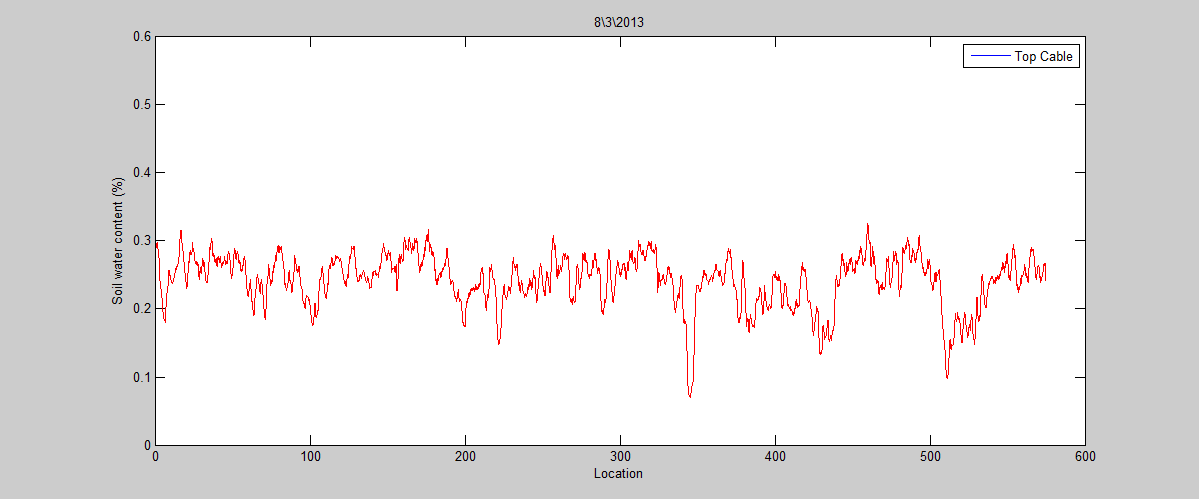
12 12
13 Precipitation recorded at the site and Soil Water Contents measured at Stations 1H and 2H 1HH 2HH 13
14 15
 0.25 m 3 m -3 (±0.04 m 3 m -3 ) 0.")
 0.16 m 3 m -3 (±0.03 m 3 m -3 ) 0.18 m 3 m -3 (±0.")
15 0.24 m 3 m -3 (±0.05 m 3 m -3 ) 0.22 m 3 m -3 (±0.03 m 3 m -3 ) 0.25 m 3 m -3 (±0.04 m 3 m -3 ) 0.41 m 3 m m 3 m m 3 m -3 (±0.03 m 3 m -3 ) 0.16 m 3 m -3 (±0.03 m 3 m -3 ) 0.18 m 3 m -3 (±0.04 m 3 m -3 ) 16

16 Challenges Logistic challenges: Batteries failure Power controller Remote communication DTS Data analysis: 5 Gb/hour Calibration/validation 17

17 Future work: Increasing Calibration Accuracy Generate distributed calibration curves: Thermal response curve generated from non disturbed samples Strategic detailed surveying of soil water content and soil thermal properties Vegetation and topography indices 18

18 Future work Publishing all data online Validation campaigns: Strategic point measurements in August and September/October LIDAR mapping of topography and vegetation height: Water-Soil-Plant Interaction 19
19 LIDAR mapping of Topograhy and Vegetation Water-Soil-Plant interaction across 0.1 m to 1000 m scales: Effect of surface topography (slope and surface storage/accumulation) Spatial variability of soil physical properties (from DTS thermal properties) Can we use vegetation height as indicator for soil water availability? Upscaling DTS measurements to represent entire field (region?): using topography and vegetation as indicators
20 Water-Soil-Plant Interaction Precipitation data DTS soil moisture measurements Soil moisture from point measurements Water Plant Vegetation Height from LIDAR Vegetation color from UAV Soil Soil surface topography 0.1m to 1000 m from LIDAR Soil physical properties from DTS thermal response at saturation Soil texture from EMI?
21 1 to 1000 m scale 22
22 <1 m scale
 DTM and DSM immediately over the regions covered")
23 Terrestrial LIDAR August 2014 >12,000 elevation readings/m 2 with m accuracy Ultra high resolution (<1cm) DTM and DSM immediately over the regions covered with FO sensing cables 24

24 Quick peek at the results 25
25 Vegetation Elevation Bare Earth Elevation Vegetation Height 26
26 Ground elevation, plant elevation, and plant height along the fiber optic cable pass 27
27 High Slope Low Slope 28

28 Summary Active DTS Soil Moisture product available in the summer Distributed calibration Dynamic calibration: Increased accuracy with more data integrated High resolution LIDAR micro-topography and vegetation height maps: Improving the accuracy of DTS products Effects of micro-topography on Hydrologic processes in the field Upscaling DTS soil moisture 29
29 Acknowledgements The material is based upon work supported by NASA under award NNX12AP58G, with equipment and assistance also provided by CTEMPs.org with support from the National Science Foundation under Grant Number Special thanks to Tyson and his team 30
Soil Moisture Estimation Using Active DTS at MOISST Site
 MOISST Workhsop, 2014 Soil Moisture Estimation Using Active DTS at MOISST Site June 4, 2014 Chadi Sayde, Daniel Moreno, John Selker Department of Biological and Ecological Engineering Oregon State University,
Christine E. Hatch University of Nevada, Reno
 Christine E. Hatch University of Nevada, Reno Roadmap What is DTS? How Does it Work? What Can DTS Measure? Applications What is Distributed Temperature Sensing (DTS)? Temperature measurement using only
Connected Farm Field Services. Dan Rooney InfoAg Conference, July 30, 2014
 Connected Farm Field Services Dan Rooney InfoAg Conference, July 30, 2014 What is Connected Farm? Connected Farm is an integrated operations management solution that combines industry-leading hardware,
II. Related Activities
 (1) Global Cloud Resolving Model Simulations toward Numerical Weather Forecasting in the Tropics (FY2005-2010) (2) Scale Interaction and Large-Scale Variation of the Ocean Circulation (FY2006-2011) (3)
EC-5 Soil Moisture Sensor
 EC-5 Soil Moisture Sensor User s Manual Version 1 Decagon Devices, Inc. 2365 NE Hopkins Court Pullman WA 99163 USA (509) 332-5600 Trademarks: ECH2O is a registered trademark of Decagon, Devices, Inc All
High Resolution RF Analysis: The Benefits of Lidar Terrain & Clutter Datasets
 0 High Resolution RF Analysis: The Benefits of Lidar Terrain & Clutter Datasets January 15, 2014 Martin Rais 1 High Resolution Terrain & Clutter Datasets: Why Lidar? There are myriad methods, techniques
EC-20, EC-10, EC-5 Soil Moisture Sensors
 EC-20, EC-10, EC-5 Soil Moisture Sensors User s Manual Version 10 Decagon Devices, Inc. 2365 NE Hopkins Court Pullman WA 99163 USA Trademarks: ECH2O is a registered trademark of Decagon, Devices, Inc All
APPLICATION OF TERRA/ASTER DATA ON AGRICULTURE LAND MAPPING. Genya SAITO*, Naoki ISHITSUKA*, Yoneharu MATANO**, and Masatane KATO***
 APPLICATION OF TERRA/ASTER DATA ON AGRICULTURE LAND MAPPING Genya SAITO*, Naoki ISHITSUKA*, Yoneharu MATANO**, and Masatane KATO*** *National Institute for Agro-Environmental Sciences 3-1-3 Kannondai Tsukuba
ECH 2 O. Soil Moisture Sensor. Operator s Manual. For Models EC-20, EC-10, and EC-5. Version 5
 ECH 2 O Soil Moisture Sensor Operator s Manual For Models EC-20, EC-10, and EC-5 Version 5 Decagon Devices, Inc. 2365 NE Hopkins Court Pullman WA 99163 USA Trademarks: ECH 2 O is a registered trademark
Global environmental information Examples of EIS Data sets and applications
 METIER Graduate Training Course n 2 Montpellier - february 2007 Information Management in Environmental Sciences Global environmental information Examples of EIS Data sets and applications Global datasets
Land Use/Land Cover Map of the Central Facility of ARM in the Southern Great Plains Site Using DOE s Multi-Spectral Thermal Imager Satellite Images
 Land Use/Land Cover Map of the Central Facility of ARM in the Southern Great Plains Site Using DOE s Multi-Spectral Thermal Imager Satellite Images S. E. Báez Cazull Pre-Service Teacher Program University
Modeling complex patterns: data-driven models and data expansion. Gregoire Mariethoz Diablerets, January 2015
 Modeling complex patterns: data-driven models and data expansion Gregoire Mariethoz Diablerets, January 2015 Modeling «simple» physical systems Some physical processes are clearly identifiable and can
Field Test to Demonstrate Real-Time In-Situ Detection of Volatile Organic Compounds Hazmat Spill Center, Nevada Test Site September 19-25, 2001
 Field Test to Demonstrate Real-Time In-Situ Detection of Volatile Organic Compounds Hazmat Spill Center, Nevada Test Site September 19-2, 21 Clifford K. Ho Sandia National Laboratories Albuquerque, NM
ACE. Automated Soil CO 2 Exchange System. Soil flux: an important component of total carbon budget
 ACE Automated Soil CO 2 Exchange System Automated operation Automatically exposes soil area between measurements CO 2 analyser in chamber Highly accurate CO 2 IRGA housed directly inside soil chamber assembly
Active and Passive Microwave Remote Sensing
 Active and Passive Microwave Remote Sensing Passive remote sensing system record EMR that was reflected (e.g., blue, green, red, and near IR) or emitted (e.g., thermal IR) from the surface of the Earth.
Multi-scale upscaling approaches of soil properties from soil monitoring data
 local scale landscape scale forest stand/ site level (management unit) Multi-scale upscaling approaches of soil properties from soil monitoring data sampling plot level Motivation: The Need for Regionalization
Monitoring Soil Moisture from Space. Dr. Heather McNairn Science and Technology Branch Agriculture and Agri-Food Canada heather.mcnairn@agr.gc.
 Monitoring Soil Moisture from Space Dr. Heather McNairn Science and Technology Branch Agriculture and Agri-Food Canada heather.mcnairn@agr.gc.ca What is Remote Sensing? Scientists turn the raw data collected
3D Model of the City Using LiDAR and Visualization of Flood in Three-Dimension
 3D Model of the City Using LiDAR and Visualization of Flood in Three-Dimension R.Queen Suraajini, Department of Civil Engineering, College of Engineering Guindy, Anna University, India, suraa12@gmail.com
Armenian State Hydrometeorological and Monitoring Service
 Armenian State Hydrometeorological and Monitoring Service Offenbach 1 Armenia: IN BRIEF Armenia is located in Southern Caucasus region, bordering with Iran, Azerbaijan, Georgia and Turkey. The total territory
Geography 403 Lecture 7 Scanners, Thermal, and Microwave
 Geography 403 Lecture 7 Scanners, Thermal, and Microwave Needs: Lect_403_7.ppt A. Basics of Passive Electric Sensors 1. Sensors absorb EMR and produce some sort of response, such as voltages differences
Create Your Own Soil Profile Ac5vity
 Create Your Own Soil Profile Ac5vity Middle School: 5-8 Task Overview: Soil profile refers to layers of soil. A typical soil profile takes nearly 1,000 to 100,000 years to form. The formation of the soil
German Test Station for Remote Wind Sensing Devices
 German Test Station for Remote Wind Sensing Devices A. Albers, A.W. Janssen, J. Mander Deutsche WindGuard Consulting GmbH, Oldenburger Straße, D-31 Varel, Germany E-mail: a.albers@windguard.de, Tel: (++9)
Pressure in Fluids. Introduction
 Pressure in Fluids Introduction In this laboratory we begin to study another important physical quantity associated with fluids: pressure. For the time being we will concentrate on static pressure: pressure
Wireless Soil Moisture and Weather Monitoring System Caipos
 Wireless Soil Moisture and Weather Monitoring System Caipos System Overview Soil moisture and weather monitoring systems Caipos System Overview Caipos consists of base station, sensors and web application.
Lake Monitoring in Wisconsin using Satellite Remote Sensing
 Lake Monitoring in Wisconsin using Satellite Remote Sensing D. Gurlin and S. Greb Wisconsin Department of Natural Resources 2015 Wisconsin Lakes Partnership Convention April 23 25, 2105 Holiday Inn Convention
METHODOLOGY FOR LANDSLIDE SUSCEPTIBILITY AND HAZARD MAPPING USING GIS AND SDI
 The 8th International Conference on Geo-information for Disaster Management Intelligent Systems for Crisis Management METHODOLOGY FOR LANDSLIDE SUSCEPTIBILITY AND HAZARD MAPPING USING GIS AND SDI T. Fernández
Selecting the appropriate band combination for an RGB image using Landsat imagery
 Selecting the appropriate band combination for an RGB image using Landsat imagery Ned Horning Version: 1.0 Creation Date: 2004-01-01 Revision Date: 2004-01-01 License: This document is licensed under a
IMPERVIOUS SURFACE MAPPING UTILIZING HIGH RESOLUTION IMAGERIES. Authors: B. Acharya, K. Pomper, B. Gyawali, K. Bhattarai, T.
 IMPERVIOUS SURFACE MAPPING UTILIZING HIGH RESOLUTION IMAGERIES Authors: B. Acharya, K. Pomper, B. Gyawali, K. Bhattarai, T. Tsegaye ABSTRACT Accurate mapping of artificial or natural impervious surfaces
Soil degradation monitoring by active and passive remote-sensing means: examples with two degradation processes
 Soil degradation monitoring by active and passive remote-sensing means: examples with two degradation processes Naftaly Goldshleger, *Eyal Ben-Dor,* *Ido Livne,* U. Basson***, and R.Ben-Binyamin*Vladimir
RS platforms. Fabio Dell Acqua - Gruppo di Telerilevamento
 RS platforms Platform vs. instrument Sensor Platform Instrument The remote sensor can be ideally represented as an instrument carried by a platform Platforms Remote Sensing: Ground-based air-borne space-borne
Arturo Sanchez-Azofeifa, PhD, PEng Cassidy Rankine, Gilberto Zonta-Pastorello Centre for Earth Observation Sciences (CEOS) Earth and Atmospheric
 Earth and Atmospheric") Arturo Sanchez-Azofeifa, PhD, PEng Cassidy Rankine, Gilberto Zonta-Pastorello Centre for Earth Observation Sciences (CEOS) Earth and Atmospheric Sciences Department University of Alberta Microsoft WSN
Arturo Sanchez-Azofeifa, PhD, PEng Cassidy Rankine, Gilberto Zonta-Pastorello Centre for Earth Observation Sciences (CEOS) Earth and Atmospheric Sciences Department University of Alberta Microsoft WSN
MOUNTING AND OPERATING INSTRUCTIONS
 MOUNTING AND OPERATING INSTRUCTIONS CF 51/55 1. Delivery CF 51/55-1 calculator with battery (optionally with mains power supply) - 1 wall mounting bracket - package with material for sealing, screws, wall
 1 2 A very short description of the functional center network: regarding the Hydraulic and Hydrogeological risk, the national alert system is ensured by the National Civil Protection Department (DPCN),
Climatology and Monitoring of Dust and Sand Storms in the Arabian Peninsula
 Climatology and Monitoring of Dust and Sand Storms in the Arabian Peninsula Mansour Almazroui Center of Excellence for Climate Change Research (CECCR) King Abdulaziz University, Jeddah, Saudi Arabia E-mail:
Integrated Global Carbon Observations. Beverly Law Prof. Global Change Forest Science Science Chair, AmeriFlux Network Oregon State University
 Integrated Global Carbon Observations Beverly Law Prof. Global Change Forest Science Science Chair, AmeriFlux Network Oregon State University Total Anthropogenic Emissions 2008 Total Anthropogenic CO 2
Ruimtelijke planning in tijden van klimaatsverandering
 Ruimtelijke planning in tijden van klimaatsverandering Eric Koomen Vrije Universiteit Amsterdam/ Geodan Next Nascholingscursus Water, rivieren en GIS' 3 april 2008 Outline Climate change climate and land
6. Base your answer to the following question on the graph below, which shows the average monthly temperature of two cities A and B.
 1. Which single factor generally has the greatest effect on the climate of an area on the Earth's surface? 1) the distance from the Equator 2) the extent of vegetative cover 3) the degrees of longitude
NASA Earth System Science: Structure and data centers
 SUPPLEMENT MATERIALS NASA Earth System Science: Structure and data centers NASA http://nasa.gov/ NASA Mission Directorates Aeronautics Research Exploration Systems Science http://nasascience.nasa.gov/
LONG TERM SOIL MOISTURE MONITORING AND ASSESSING THEORETICAL DATA INTERPRETATION TECHNIQUES USING HEATED DISTRIBUTED TEMPERATURE SENSING
 LONG TERM SOIL MOISTURE MONITORING AND ASSESSING THEORETICAL DATA INTERPRETATION TECHNIQUES USING HEATED DISTRIBUTED TEMPERATURE SENSING By John J. Sourbeer A Thesis submitted in partial fulfillment of
Remote Sensing in Natural Resources Mapping
 Remote Sensing in Natural Resources Mapping NRS 516, Spring 2016 Overview of Remote Sensing in Natural Resources Mapping What is remote sensing? Why remote sensing? Examples of remote sensing in natural
3D Building Roof Extraction From LiDAR Data
 3D Building Roof Extraction From LiDAR Data Amit A. Kokje Susan Jones NSG- NZ Outline LiDAR: Basics LiDAR Feature Extraction (Features and Limitations) LiDAR Roof extraction (Workflow, parameters, results)
Notable near-global DEMs include
 Visualisation Developing a very high resolution DEM of South Africa by Adriaan van Niekerk, Stellenbosch University DEMs are used in many applications, including hydrology [1, 2], terrain analysis [3],
defined largely by regional variations in climate
 1 Physical Environment: Climate and Biomes EVPP 110 Lecture Instructor: Dr. Largen Fall 2003 2 Climate and Biomes Ecosystem concept physical and biological components of environment are considered as single,
Ubiquitous Wireless Sensor Networks for Environmental and Climate Data Management System
 Ubiquitous Wireless Sensor Networks for Environmental and Climate Data Management System Presenter: M.Eng Vo Minh Thanh School of Electrical Engineering International University HCM National University
AirborneHydroMapping. New possibilities in bathymetric and topographic survey
 AirborneHydroMapping New possibilities in bathymetric and topographic survey AIRBORNE HYDROMAPPING (2008 2011) Layout needs from water engineering side: - Shallow water applications - High point density
Welcome to NASA Applied Remote Sensing Training (ARSET) Webinar Series
 Webinar Series") Welcome to NASA Applied Remote Sensing Training (ARSET) Webinar Series Introduction to Remote Sensing Data for Water Resources Management Course Dates: October 17, 24, 31 November 7, 14 Time: 8-9 a.m.
Welcome to NASA Applied Remote Sensing Training (ARSET) Webinar Series Introduction to Remote Sensing Data for Water Resources Management Course Dates: October 17, 24, 31 November 7, 14 Time: 8-9 a.m.
WATER AND DEVELOPMENT Vol. II - Types Of Environmental Models - R. A. Letcher and A. J. Jakeman
 TYPES OF ENVIRONMENTAL MODELS R. A. Letcher and A. J. Jakeman Centre for Resource and Environmental Studies, The Australian National University, Australia Keywords: environmental models, environmental
City of Calgary KISTERS KISTERS Overview Overview. KISTERS Software Solutions Water, Energy and Environmental Data May 19, 2015
 KISTERS Software Solutions Water, Energy and Environmental Data May 19, 2015 Who is KISTERS? Applications Modular Solutions Current Technologies Working with Your Data Discussion Applications Hydrometric
In c r e a s i n g en v ironmen ta l ch a llenges w o r l d w i d e and a growing
 EARTH AND ENVIRONMENT Instrumenting the Earth: Next-Generation Sensor Networks and Environmental Science In c r e a s i n g en v ironmen ta l ch a llenges w o r l d w i d e and a growing awareness of global
Comprehensive Data Collection by Sensor Network and Optical Sensor for Agricultural Big Data
 Comprehensive Data Collection by Sensor Network and Optical Sensor for Agricultural Big Data Masayuki HIRAFUJI* ** * NARO National Agriculture and Food Research Organization ** University of Tsukuba Big
MONITORING OF DROUGHT ON THE CHMI WEBSITE
 MONITORING OF DROUGHT ON THE CHMI WEBSITE Richterová D. 1, 2, Kohut M. 3 1 Department of Applied and Land scape Ecology, Faculty of Agronomy, Mendel University in Brno, Zemedelska 1, 613 00 Brno, Czech
Evaluation of surface runoff conditions. scanner in an intensive apple orchard
 Evaluation of surface runoff conditions by high resolution terrestrial laser scanner in an intensive apple orchard János Tamás 1, Péter Riczu 1, Attila Nagy 1, Éva Lehoczky 2 1 Faculty of Agricultural
CHUVA. by CHUVA Science Team. 4 th CHUVA Planning Meeting 13 December 2010 San Francisco, CA. Rachel I. Albrecht rachel.albrecht@cptec.inpe.
 CHUVA Cloud processes of the main precipitation systems in Brazil: A contribution to cloud resolving modeling and to the GPM (GlobAl Precipitation Measurement) by CHUVA Science Team Rachel I. Albrecht
Future needs of remote sensing science in Antarctica and the Southern Ocean: A report to support the Horizon Scan activity of COMNAP and SCAR
 Future needs of remote sensing science in Antarctica and the Southern Ocean: A report to support the Horizon Scan activity of COMNAP and SCAR Thomas Wagner (thomas.wagner@nasa.gov) Charles Webb NASA Cryospheric
COMPARISON OF LIDARS, GERMAN TEST STATION FOR REMOTE WIND SENSING DEVICES
 COMPARISON OF LIDARS, GERMAN TEST STATION FOR REMOTE WIND SENSING DEVICES A. Albers, A.W. Janssen, J. Mander Deutsche WindGuard Consulting GmbH, Oldenburger Straße, D-31 Varel, Germany E-mail: a.albers@windguard.de,
Remote sensing is the collection of data without directly measuring the object it relies on the
 Chapter 8 Remote Sensing Chapter Overview Remote sensing is the collection of data without directly measuring the object it relies on the reflectance of natural or emitted electromagnetic radiation (EMR).
Introducing AUDIT-BUDDY
 Introducing AUDIT-BUDDY Optimize the Data Center with AUDIT-BUDDY Executive Summary Proper temperature and humidity for the inlet air into the servers is essential to efficient data center operation. Several
How To Model Soil On Gri
 TECHNICAL NOTE ON USING HELP MODEL (VER. 3.07) I: INPUT STEPS GUIDE The purpose of this document is to help the users of HELP Model through the input procedures, and interpretation of the output results.
D.S. Boyd School of Earth Sciences and Geography, Kingston University, U.K.
 PHYSICAL BASIS OF REMOTE SENSING D.S. Boyd School of Earth Sciences and Geography, Kingston University, U.K. Keywords: Remote sensing, electromagnetic radiation, wavelengths, target, atmosphere, sensor,
Application of Numerical Weather Prediction Models for Drought Monitoring. Gregor Gregorič Jožef Roškar Environmental Agency of Slovenia
 Application of Numerical Weather Prediction Models for Drought Monitoring Gregor Gregorič Jožef Roškar Environmental Agency of Slovenia Contents 1. Introduction 2. Numerical Weather Prediction Models -
Figure 1.1 The Sandveld area and the Verlorenvlei Catchment - 2 -
 Figure 1.1 The Sandveld area and the Verlorenvlei Catchment - 2 - Figure 1.2 Homogenous farming areas in the Verlorenvlei catchment - 3 - - 18 - CHAPTER 3: METHODS 3.1. STUDY AREA The study area, namely
THE GEORGIA AUTOMATED ENVIRONMENTAL MONITORING NETWORK: TEN YEARS OF WEATHER INFORMATION FOR WATER RESOURCES MANAGEMENT
 THE GEORGIA AUTOMATED ENVIRONMENTAL MONITORING NETWORK: TEN YEARS OF WEATHER INFORMATION FOR WATER RESOURCES MANAGEMENT Gerrit Hoogenboom, D.D. Coker, J.M. Edenfield, D.M. Evans and C. Fang AUTHORS: Department
Black Tern Distribution Modeling
 Black Tern Distribution Modeling Scientific Name: Chlidonias niger Distribution Status: Migratory Summer Breeder State Rank: S3B Global Rank: G4 Inductive Modeling Model Created By: Joy Ritter Model Creation
WEATHER STATION FOR SOLAR FARM MONITORING
 WEATHER STATION FOR SOLAR FARM MONITORING SOLAR FARM MONITORING SYSTEM: Measures global, horizontal, & background irradiance. Measures wind speed, wind direction, ambient temperature, and relative humidity.
Distributed Temperature Sensing - DTS
 Intelligent Solutions Distributed Temperature Sensing - DTS Enabling fast, reliable and cost-effective sensing through highly integrated optical measurement systems Fire detection Power cable monitoring
Pore size and BET surface area. analysis at your fingertips. SA 3100. Gas Adsorption Analyzer
 Pore size and BET surface area analysis at your fingertips. SA 3100 Gas Adsorption Analyzer The History of Beckman Coulter Particle Characterization Introducing The SA 3100 Surface Area and Pore Size Analyzer
Remote Sensing an Introduction
 Remote Sensing an Introduction Seminar: Space is the Place Referenten: Anica Huck & Michael Schlund Remote Sensing means the observation of, or gathering information about, a target by a device separated
DISSOLVED OXYGEN METER Model : DO-5509
 DISSOLVED OXYGEN METER Model : DO-5509 Your purchase of this DISSOLVED OXYGEN METER marks a step forward for you into the field of precision measurement. Although this DISSOLVED OXYGEN METER is a complex
Seasonal & Daily Temperatures. Seasons & Sun's Distance. Solstice & Equinox. Seasons & Solar Intensity
 Seasonal & Daily Temperatures Seasons & Sun's Distance The role of Earth's tilt, revolution, & rotation in causing spatial, seasonal, & daily temperature variations Please read Chapter 3 in Ahrens Figure
Chapter D9. Irrigation scheduling
 Chapter D9. Irrigation scheduling PURPOSE OF THIS CHAPTER To explain how to plan and schedule your irrigation program CHAPTER CONTENTS factors affecting irrigation intervals influence of soil water using
Real-time hazard impact modelling for surface water flooding: some UK developments
 Real-time hazard impact modelling for surface water flooding: some UK developments Steven Cole 1, Bob Moore 1, Timothy Aldridge 2, Andy Lane 3,4 and Stefan Laeger 4 International Conference on Flood Resilience,
Saharan Dust Aerosols Detection Over the Region of Puerto Rico
 1 Saharan Dust Aerosols Detection Over the Region of Puerto Rico ARLENYS RAMÍREZ University of Puerto Rico at Mayagüez, P.R., 00683. Email:arlenys.ramirez@upr.edu ABSTRACT. Every year during the months
Temperature Rise Measurements
 Chapter 22 Temperature Rise Measurements 22.1 Background The SAR in tissue simulating liquid can be assessed by means of temperature rise or by measurements of induced electric field. SAR = c T dt (22.1)
N4385A / N4386A Distributed Temperature System (DTS)
") N4385A / N4386A Distributed Temperature System (DTS) Enabling fast, reliable and cost-effective sensing through highly integrated optical measurement systems s Distributed Temperature Sensing Oil & Gas
N4385A / N4386A Distributed Temperature System (DTS) Enabling fast, reliable and cost-effective sensing through highly integrated optical measurement systems s Distributed Temperature Sensing Oil & Gas
A-Series Data Loggers PRODUCT MANUAL
 A-Series Data Loggers PRODUCT MANUAL Model # s A110, A125, A130, and A150 Contents Model Specifications 2 Connecting to the Computer 3 SpecWare Software 4 Installation and Placement 6 Battery Replacement
A remote sensing instrument collects information about an object or phenomenon within the
 Satellite Remote Sensing GE 4150- Natural Hazards Some slides taken from Ann Maclean: Introduction to Digital Image Processing Remote Sensing the art, science, and technology of obtaining reliable information
Using Optech LMS to Calibrate Survey Data Without Ground Control Points
 Challenge An Optech client conducted an airborne lidar survey over a sparsely developed river valley. The data processors were finding that the data acquired in this survey was particularly difficult to
Fundamentals of Climate Change (PCC 587): Water Vapor
: Water Vapor") Fundamentals of Climate Change (PCC 587): Water Vapor DARGAN M. W. FRIERSON UNIVERSITY OF WASHINGTON, DEPARTMENT OF ATMOSPHERIC SCIENCES DAY 2: 9/30/13 Water Water is a remarkable molecule Water vapor
Fundamentals of Climate Change (PCC 587): Water Vapor DARGAN M. W. FRIERSON UNIVERSITY OF WASHINGTON, DEPARTMENT OF ATMOSPHERIC SCIENCES DAY 2: 9/30/13 Water Water is a remarkable molecule Water vapor
CRMS Website Training
 CRMS Website Training March 2013 http://www.lacoast.gov/crms Coastwide Reference Monitoring System - Wetlands CWPPRA Restoration Projects Congressionally funded in 1990 Multiple restoration techniques
Course Outline MS Global Environmental Change candidates are required to complete the core module, as well as three compulsory modules:
 ISA Master s Degrees in Sustainability Degree Title Master of Science in Global Environmental Change University King s College University Overview King's College London, ranked among the top 25 universities
Long-Term Hygrothermal Performance of Green Roofs
 Long-Term Hygrothermal Performance of Green Roofs D. Zirkelbach B. Schafaczek H. Künzel, PhD Member ASHRAE ABSTRACT Green roofs are becoming more and more popular because their thermal inertia, combined
Satellite derived Groundwater Storage Es4mates and Opportuni4es for Expanding Research in Arid Environments
 Satellite derived Groundwater Storage Es4mates and Opportuni4es for Expanding Research in Arid Environments NASA Ames DEVELOP Program Summer 2011 Amber Kuss, San Francisco State University William Brandt,
Permanent Distributed Temperature Sensing at the Ketzin CO 2 Storage Test Site. ieaghg 6th Wellbore Network Meeting, April 28-29, 2010
 Permanent Distributed Temperature Sensing at the Ketzin CO 2 Storage Test Site Jan Henninges ieaghg 6th Wellbore Network Meeting, April 28-29, 2010 Introduction Objectives of temperature measurements at
Basic Climatological Station Metadata Current status. Metadata compiled: 30 JAN 2008. Synoptic Network, Reference Climate Stations
 Station: CAPE OTWAY LIGHTHOUSE Bureau of Meteorology station number: Bureau of Meteorology district name: West Coast State: VIC World Meteorological Organization number: Identification: YCTY Basic Climatological
THE ECOSYSTEM - Biomes
 Biomes The Ecosystem - Biomes Side 2 THE ECOSYSTEM - Biomes By the end of this topic you should be able to:- SYLLABUS STATEMENT ASSESSMENT STATEMENT CHECK NOTES 2.4 BIOMES 2.4.1 Define the term biome.
The Live Land Project ARTES Applications Workshop 19 th April 2013
 The Live Land Project ARTES Applications Workshop 19 th April 2013 Contents 1. Overview of project, expected outputs and benefits 2. ESA, Industry Partners and Clients involvement 3. Outline of programme
The AIR Inland Flood Model for the United States In Spring 2011, heavy rainfall and snowmelt produced massive flooding along the Mississippi River,
 The AIR Inland Flood Model for the United States In Spring 2011, heavy rainfall and snowmelt produced massive flooding along the Mississippi River, inundating huge swaths of land across seven states. As
The X100. Safe and fully automatic. Fast and with survey accuracy. revolutionary mapping. create your own orthophotos and DSMs
 The X100 revolutionary mapping Safe and fully automatic create your own orthophotos and DSMs Fast and with survey accuracy operates even in harsh weather conditions (up to 65 km/h wind & light rain) Image
Instrumentation for the Plant & Soil Sciences Short Form Catalog
 Instrumentation for the Plant & Soil Sciences Short Form Catalog www.ppsystems.com Trusted and tested technology CIRAS-2 Portable Photosynthesis System PLC6 (U) Automatic Universal Leaf Cuvette For High
INTEGRATED GEOPHYSICAL AND REMOTE SENSING STUDIES ON GROTTA GIGANTE SHOW CAVE (TRIESTE ITALY) P. Paganini, A. Pavan, F. Coren, A.
 P. Paganini, A. Pavan, F. Coren, A.") INTEGRATED GEOPHYSICAL AND REMOTE SENSING STUDIES ON GROTTA GIGANTE SHOW CAVE (TRIESTE ITALY) P. Paganini, A. Pavan, F. Coren, A. Fabbricatore Aerial lidar survey - strumentation Piper Seneca II - PA34
INTEGRATED GEOPHYSICAL AND REMOTE SENSING STUDIES ON GROTTA GIGANTE SHOW CAVE (TRIESTE ITALY) P. Paganini, A. Pavan, F. Coren, A. Fabbricatore Aerial lidar survey - strumentation Piper Seneca II - PA34
Passive Remote Sensing of Clouds from Airborne Platforms
 Passive Remote Sensing of Clouds from Airborne Platforms Why airborne measurements? My instrument: the Solar Spectral Flux Radiometer (SSFR) Some spectrometry/radiometry basics How can we infer cloud properties
Monsoon Variability and Extreme Weather Events
 Monsoon Variability and Extreme Weather Events M Rajeevan National Climate Centre India Meteorological Department Pune 411 005 rajeevan@imdpune.gov.in Outline of the presentation Monsoon rainfall Variability
Solar Resource & Radiometry Tasks in Antofagasta
 Solar Resource & Radiometry Tasks in Antofagasta, Ph.D. aitor.marzo@uantof.cl Mauricio Trigo, Mg. Tania Varas, Mg. Antofagasta, January 14nd, 2015 Index Introduction to Solar Radiation Measurements Climates
Monitoring Hydrological Changes Related to Western Juniper Removal: A Paired Watershed Approach
 Monitoring Hydrological Changes Related to Western Juniper Removal: A Paired Watershed Approach T.L. Deboodt, M.P. Fisher, J.C. Buckhouse, John Swanson Abstract Since 1934, western juniper has increased
Operator s Manual. Decagon Devices, Inc. Version: February 29, 2016 11:10:55
 Operator s Manual Decagon Devices, Inc. Version: February 29, 2016 11:10:55 LWS Decagon Devices, Inc. 2365 NE Hopkins Court Pullman WA 99163 Phone: 509-332-5600 Fax: 509-332-5158 Website: www.decagon.com
National and Sub-national Carbon monitoring tools developed at the WHRC
 National and Sub-national Carbon monitoring tools developed at the WHRC Nadine Laporte Woods Hole Research Center A. Baccini, W. Walker, S. Goetz, M. Sun, J. Kellndorfer Kigali, 20 th June 2011 Why measuring
Joint Polar Satellite System (JPSS)
") Joint Polar Satellite System (JPSS) John Furgerson, User Liaison Joint Polar Satellite System National Environmental Satellite, Data, and Information Service National Oceanic and Atmospheric Administration
Joint Polar Satellite System (JPSS) John Furgerson, User Liaison Joint Polar Satellite System National Environmental Satellite, Data, and Information Service National Oceanic and Atmospheric Administration
1000 Series Data Loggers PRODUCT MANUAL
 1000 Series Data Loggers PRODUCT MANUAL Model s 1650, 1525, 1450, 1425, 1400, 1250, 1225, 1200 CONTENTS General Overview 3 Model Specifications 4 External Sensors 5 Installation and Placement 6 Digital
BCTC/BC Hydroʹs operational experience with Distributed Temperature Sensing (DTS) Systems for Transmission Cables. Presented by
 Systems for Transmission Cables. Presented by") BCTC/BC Hydroʹs operational experience with Distributed Temperature Sensing (DTS) Systems for Transmission Cables Presented by S. Cherukupalli Transmission Cables Design BC Hydro at the ICC Spring Meeting,
BCTC/BC Hydroʹs operational experience with Distributed Temperature Sensing (DTS) Systems for Transmission Cables Presented by S. Cherukupalli Transmission Cables Design BC Hydro at the ICC Spring Meeting,
Submitted to: Submitted by: Department of Geology and Mineral Industries 800 NE Oregon Street, Suite 965 Portland, OR 97232
 LIDAR REMOTE SENSING DATA COLLECTION DEPARTMENT OF F GEOLOGY AND MINERAL INDUSTRIES CRATER LAKE, OREGON NOVEMBER 30, 2010 Submitted to: Department of Geology and Mineral Industries 800 NE Oregon Street,