Developing National Web Services and SDI Tambet Tiits, FRICS
|
|
|
- Marvin Douglas
- 7 years ago
- Views:
Transcription
1 Developing National Web Services and SDI Tambet Tiits, FRICS

2 Government agency founded in 1990 under the jurisdiction of the Ministry of the Environment. 290 employees State funding 100% Estonian Land Board

3 Basic Values Openness, transparency, trustworthiness, ethics, respect Readiness to act, presence Input from every employee is essential for success Provision of easy-to-understand and user-friendly services Service - minded and customer-oriented attitude Services are of high quality

4 Main Fields of Activity Implementation of land policy Maintenance of land cadastre Mapping and Geoinformatics Capture and management of geodetic, geological and topographic data Land valuation

5 Main Rules of the Estonian Information Policy Distributed service based architecture Suitable security of data and data-exchange Online features Focus on e-services The use of strong authentication measures

6 National Digital Strategy Basic documents for national strategy: - Digital Agenda 2020 for Estonia - Interoperability Framework The Land Board is responsible for the development of strategy for spatial data services: - Spatial Data Act (adopted in 2011) The Land Board contributes to the development of national strategies (GIS related issues) and ensures that its own strategic documents (development plans) are in line with national principles
 and ensures that its own strategic documents (development plans) are in line")
7 List of Estonia's digital firsts 2000 E-government with paperless e-cabinet sessions 2000 Mobile parking system 2001 X-Road implemented, the de-centralized backbone to all public e- services 2002 Introduction of mobile payments and digital signature 2005 World's first internet voting in official elections 2005 DigiDoc system for signing, storing and sharing documents 2009 Electronic registration of companies (up and running in 15 minutes) % of banking transactions are done electronically in Estonia 2014 Estonia launches the world's first e-residency
 2014 99% of banking transactions are done electronically in Estonia 2014 Estonia launches the world's first")
8 X-Road X-Road is a technical and organisational environment, which enables Internet-based data exchange between the state s information systems Public and private sector enterprises and institutions can connect their information systems with the X-Road, services can be added one at a time, as they are ready Over 170 databases offer their services over X-Road in Estonia Over 2,000 services are used over X-Road Over 900 organisations use X-Road daily Over 50% of the inhabitants of Estonia use X-Road through the information portal: eesti.ee.

9
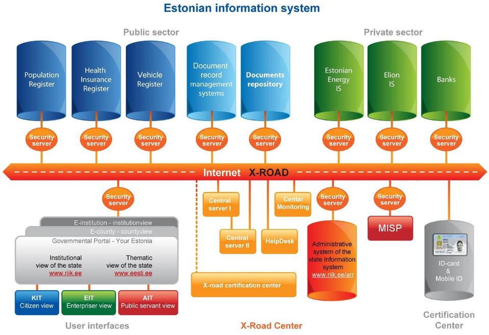
10 X-Road and the Land Board Of our data sets the following are provided to customers over X- Road: - Address Data System - Place Names Register - Mineral Deposits of the Environmental Register - Estonian Topographic Database - Land Tax Information System - Cadastre Altogether 66 active services

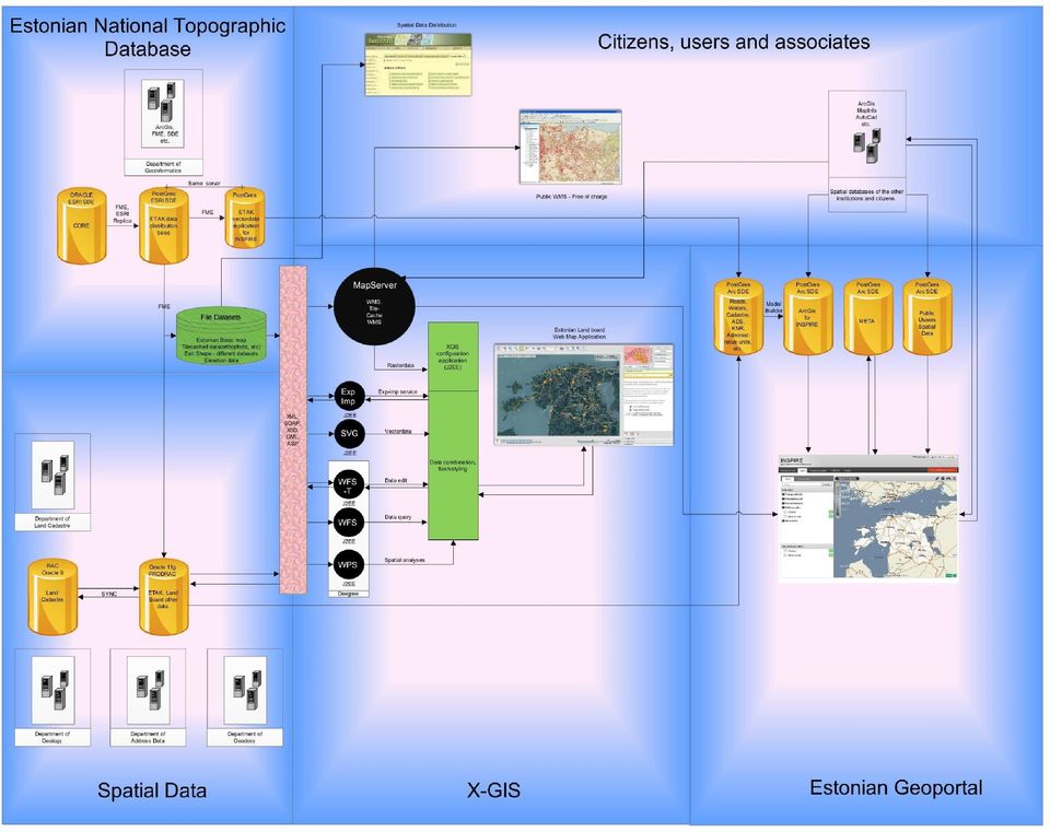
11 X-GIS The first map application was developed in 2001 for publication of cadastral data In 2007, a new web-based map server, X-GIS, was launched, which was based on open standards (WMS, WFS, etc.) X-GIS includes an administration module, new map applications can be added very easily Over 70 thematic map applications, most of them are public and free Data producing module enables to authenticate, create and edit data We also host the data of other state agencies. Currently, e.g. spatial data of heritage objects and of roads are maintained in our environment In Estonia X-GIS is very popular, in a way it is the X-Road for spatial data

12
13

14 Geoportals Currently the Land Board manages two geoportals: Land Board s Geoportal ( - Launched in Self tailored - Oriented to the Land Board s data and services - Map application is X-GIS
 - Launched in 2009 - Self tailored - Oriented to")
15

16 Geoportals Estonian Geoportal ( ) - Launched in Outsourced - Part of the first INSPIRE development project - A gateway through which spatial data, metadata and services, including INSPIRE compatible services, are published and made available - Part of the Estonian NSDI

17

18 INSPIRE Implementation The Land Board is INSPIRE contact point and also responsible for the majority of Annex I/II INSPIRE themes and for part of Annex III themes Stage I technical infrastructure, central INSPIRE database, data harmonisation, discovery and view services for Annex I data was developed Stage II (ongoing) harmonisation of Annex II and part of Annex III themes, download services, most Annex I and II data will be compatible with data model version 4.0 By end of this project the majority of our data will be conformant to INSPIRE Stage III implementation according to the roadmap INSPIRE services are made available through the Estonian Geoportal at

19 Use of Our Services Web Map Server e.g. in April 2015 more than requests Base services (WMS, WFS) e.g. in May 2015 more than requests Land Board s homepage requests per month Hits in the Map Server per month more than 180 million All view web services are free to use for everybody

20 Customer Satisfaction Users have received our services well There is a constant increase in the use We have been offering something new all the time (new map layers, added possibilities) and maintained a high quality Data is as up-to-date as possible We monitor the use of services and analyse the feedback from users Web Map Services are widely used in web map portals of both the public and private sectors

21 Impact of Spatial Data Services on the Land Board Need for manual work has been reduced Customers obtain more and more information from web services The competencies of employees in the field of spatial data have improved We can provide the society with up-to-date spatial data straight from the source The quality of services has improved considerably Economic and social effects are more user related and therefore more difficult to measure
22 Plans for Future Continued development of systems Implementation of INSPIRE according to the roadmap Consolidation of different service environments New services concentrating even more on customer needs - supported mobile platforms - oriented more to specific users, not only for publication of data
23 Conclusions Provision of data through services has been a right choice the Land Board s data are widely used It is extremely important to guarantee the quality and up-to-dateness of data that serve as basis for decision making Estonia, being a small country, is an ideal place for the implementation of new and innovative solutions
24 Thank you! Further information: geoportaal.maaamet.ee
NIPP. Ivica Skender NSDI Working group for technical standards
 Implementing rules for network services Ivica Skender NSDI Working group for technical standards ivica.skender@gisdata.com Content Working group for technical standards INSPIRE implementing rule for Network
Enabling embedded maps
 Enabling embedded maps Case: National geoportal of Finland Antti Rainio National Land Survey of Finland Trends: Web Services, Mapping Mashup, Open Source, Open Data Decentralised data s Service interfaces
EDI legal aspects in Estonia
 EDI legal aspects in Estonia Sharing the experience: einvoicing Riga, ECR Baltic seminar, April 15, 2010 Taavi Valdlo Department of State Information Systems Ministry of Economic Affairs and Communications
Cadastre in the context of SDI and INSPIRE
 Cadastre in the context of SDI and INSPIRE Dr. Markus Seifert Bavarian Administration for Surveying and Cadastre Cadastre in the digital age the approach in Germany 3 rd CLGE Conference, Hanover, 11.10.2012
Development and the capacity building of the spatial information infrastructure geoportalin Poland
 Development and the capacity building of the spatial information infrastructure geoportalin Poland Marcin Grudzień, Eliza Asendy, Agnieszka Gruchała 25th June 2012, ISTANBUL Agenda GEOPORTAL 2 Main productsof
Interoperability Support systems Nationwide components (Estonia)
") Interoperability Support systems Nationwide components (Estonia) July 6, 2007 Forum Standaardisatie, Netherland Uuno Vallner, PhD. Ministry of Economic Affairs and Communications ICT legislation (1) Personal
Interoperability Support systems Nationwide components (Estonia) July 6, 2007 Forum Standaardisatie, Netherland Uuno Vallner, PhD. Ministry of Economic Affairs and Communications ICT legislation (1) Personal
PDOK Kaart, the Dutch Mapping API
 PDOK Kaart, the Dutch Mapping API Haico van der Vegt*, Leo van der Sluijs* * Cadastre, Land Registry and Mapping Agency of the Netherlands Abstract. PDOK (public services on the map) is a partnership of
Spatial Data Infrastructure. A Collaborative Network
 Spatial Data Infrastructure A Collaborative Network Solving Challenges Takes Collaboration Social challenges, environmental issues, and economic downturns all take cooperation to solve. Working together
African European Georesources Observation System
 African European Georesources Observation System Spatial Data Infrastructure (SDI) Dr. Andreas Barth, Bernd Torchala Beak, Germany Outline Project Overview AEGOS SDI data / services hardware / software
Making Geospatial Data Available and Accessible in Jamaica
 Making Geospatial Data Available and Accessible in Jamaica Presented by Cecille Blake, National GIS Coordinator Office of the Prime Minister, National Spatial Data Management Division 9 th UNRCC New York
Distributed Data Management in Internet Map Services
 Distributed Data Management in Internet Map Services Experiences from Lounaispaikka Thematic Atlas Antti Vasanen Regional Council of Southwest Finland Lounaispaikka Lounaispaikka is a regional non-profit
Technology Trends In Geoinformation
 Technology Trends In Geoinformation Dato Prof. Sr Dr. Abdul Kadir Bin Taib Department of Survey and Mapping Malaysia (JUPEM) Email: drkadir@jupem.gov.my www.jupem.gov.my NGIS 2008 3 rd. National GIS Conference
Spatial Data Infrastructure of the Russian Federation: a new paradigm of openness
 Spatial Data Infrastructure of the Russian Federation: a new paradigm of openness Sergey Sapelnikov, Deputy Chairman of Rosreestr The Federal Service For State Registration, Cadaster and Cartography (ROSREESTR)
Building up a SDI What is needed? Ulla Kronborg Mazzoli Danish ministry for the Environment National Survey and Cadastre
 Building up a SDI What is needed? Ulla Kronborg Mazzoli Danish ministry for the Environment National Survey and Cadastre He who knows all the answers has not yet been asked all the questions. - Author
An Esri White Paper June 2011 ArcGIS for INSPIRE
 An Esri White Paper June 2011 ArcGIS for INSPIRE Esri, 380 New York St., Redlands, CA 92373-8100 USA TEL 909-793-2853 FAX 909-793-5953 E-MAIL info@esri.com WEB esri.com Copyright 2011 Esri All rights reserved.
Strategy for Improving Cadastral Spatial Quality toward Effective e- Government based NSDI
 Strategy for Improving Cadastral Spatial Quality toward Effective e- Government based NSDI Young-ho LEE, Republic of Korea Key words: e-government, interoperability, NSDI, Spatial quality SUMMARY E-Government
X-Road. egovernment interoperability framework
 X-Road egovernment interoperability framework Serving e-nation over 10 years Backbone of the Estonian egovernment 12 years of active duty, no downtime Over 2000 connected e-services More than 900 connected
Establishment of Spatial Data Infrastructure within the Environmental Sector in Slovak Republic
 EnviroInfo 2005 (Brno) Informatics for Environmental Protection - Networking Environmental Information Establishment of Spatial Data Infrastructure within the Environmental Sector in Slovak Republic Martin
Spatial Data Infrastructure as Tools in Environment and Geohazard Management. Examples from Norway
 Spatial Data Infrastructure as Tools in Environment and Geohazard Management. Examples from Norway Kari STRANDE, Norway Key words: e-governance, Geoinformation, GSDI, Risk management, Spatial Planing SUMMARY
E-signature in the Austrian cadastral process
 E-signature in the Austrian cadastral process Content Facts and figures Processes in Cadastre and Land Registry New Processes and procedures Legal framework Process of application Registration of changes
Implementation in Germany
 Step by step towards INSPIRE Implementation in Germany INSPIRE Conference 2010 National Frameworks Kraków, 23 June 2010 Martin Lenk SDI Office Germany Federal Agency for Cartography and Geodesy Overview
From Geoportal to Spatial Data Service Platform. Jani Kylmäaho National Land Survey of Finland Development Centre
 From Geoportal to Spatial Data Service Platform Jani Kylmäaho National Land Survey of Finland Development Centre 29.6.2012 Introduction National Land Survey of Finland - 1900 employees Development Centre
e-estonia Strategic decisions for success
 e-estonia Strategic decisions for success e-estonia e-estonia e-estonia e-estonia e-estonia e-estonia Just to remind you. We are a very small country in a cold Nordic neighborhood! e-estonia Just to remind
Call for experts for INSPIRE maintenance & implementation
 INSPIRE Infrastructure for Spatial Information in Europe Call for experts for INSPIRE maintenance & implementation Title Creator Call for experts for INSPIRE maintenance & implementation EC & EEA INSPIRE
Francesco Tortorelli
 Francesco Tortorelli Joint CEN/TC 287 and OGC Workshop Bringing GI Standards-making bodies together Frascati (Rome), 30 September 2013 (AgID) AgID (previously CNIPA and DigitPA) is a government agency
Building a SDI for small countries the Portuguese example
 Building a SDI for small countries the Portuguese example Rui Pedro Julião Instituto Geográfico Português Deputy Director-General rpj@igeo.pt Abstract Portugal was one of the SDI pioneers in the beginning
Polish Spatial Data Infrastructure - from the Concept towards its Implementation
 Polish Spatial Data Infrastructure - from the Concept towards its Implementation 8th EC-GI&GIS Workshop ESDI A Work in Progress Dublin, July 3-5 June 2001 r. Adam Linsenbarth, Ewa Wysocka Institute of
SPATIAL DATA WEB SERVICES PRICING MODEL INRASTRUCTURE
 SPATIAL DATA WEB SERVICES PRICING MODEL INRASTRUCTURE L.Ozmus 1,B.Erkek 2,S.Colak 3, I.Cankurt 4 and S.Bakıcı 5 1 General Directorate of Land Registry and Cadastre, Ankara, Turkey, lozmus@gmail.com 2 General
THE SPATIAL DATA INFRASTRUCTURE OF SPAIN AS AN EXAMPLE OF SUCCESS IN EUROPE
 THE SPATIAL DATA INFRASTRUCTURE OF SPAIN AS AN EXAMPLE OF SUCCESS IN EUROPE Julio Mezcua-Rodríguez (jmezcua@fomento.es) Instituto Geográfico Nacional (National Geographic Institute). General Ibañez Ibero,
The Spatial Data Infrastructure of Spain as an example of success in Europe *
 UNITED NATIONS E/CONF.99/IP.16 ECONOMIC AND SOCIAL COUNCIL Ninth United Nations Regional Cartographic Conference for the Americas New York, 10-14 August 2009 Item 7(b) of the provisional agenda Best Practices
How To Write An Inspire Directive
 INSPIRE Infrastructure for Spatial Information in Europe Detailed definitions on the INSPIRE Network Services Title Detailed definitions on the INSPIRE Network Services Creator Date 2005-07-22 Subject
Embedding digital signature technology to other systems - Estonian practice. Urmo Keskel SK, DigiDoc Product Manager
 Embedding digital signature technology to other systems - Estonian practice Urmo Keskel SK, DigiDoc Product Manager E-stonia? Population: 1.35M Internet usage: 54% Internet banking: 72% Mobile penetration:
GIS Data Models for INSPIRE and ELF
 GIS Data Models for INSPIRE and ELF Paul Hardy Roberto Lucchi EuroSDR/ELF Copenhagen Data Modelling and Model Driven Implementation of Data Distribution 28 Jan 2015 ArcGIS for INSPIRE Extends ArcGIS for
Slovakia on (winding) Road to Information Society
 Road to Information Society") Slovakia on (winding) Road to Information Society Experience, Problems and Perspectives Non-governmental organization viewpoint Igor Prívara Slovak Society for Computer Science Institute of Informatics
Slovakia on (winding) Road to Information Society Experience, Problems and Perspectives Non-governmental organization viewpoint Igor Prívara Slovak Society for Computer Science Institute of Informatics
The Delaware DataMIL A Pilot Project for The National Map. April 18, 2002 Delaware GIS Conference: Connecting Communities
 The Delaware DataMIL A Pilot Project for The National Map April 18, 2002 Delaware GIS Conference: Connecting Communities The DataMIL Team University of Delaware Christina Callahan, Research & Data Management
LOGICAL DATA MODEL FOR DISSEMINATION OF SPATIAL DATA
 S&T Slovenia - Hermes Plus d.d. Oracle Business Unit, Ljubljana LOGICAL DATA MODEL FOR DISSEMINATION OF SPATIAL DATA by Joze Senegacnik Chief Technology Officer e-mail: joze.senegacnik@hermes-plus.si Ljubljana,
IT Developments Enabling Customer-Oriented Cadastre 1
 1 Bogdan NEY and Andrzej SAMBURA, Poland 1. ROAD FROM PRODUCER-ORIENTED TO CUSTOMER-ORIENTED CADASTRE 1.1 Current Situation The current situation in cadastre is characterized by three main factors. Firstly,
INTRODUCTION TO ISO 9001 REVISION - COMMITTEE DRAFT
 INTRODUCTION TO ISO 9001 REVISION - COMMITTEE DRAFT AGENDA Introduction Annex SL Changes to ISO 9001 Future Development How SGS can support you 2 INTRODUCTION ISO 9001 Revision Committee Draft Issued 2013
Plan on establishment of National Committee on Geographical Names and Spatial Data Infrastructure in Viet Nam *
 UNITED NATIONS E/CONF.104/IP.23 ECONOMIC AND SOCIAL COUNCIL Twentieth United Nations Regional Cartographic Conference for Asia and the Pacific Jeju, 6-9 October 2015 Item 7(b) of the provisional agenda
Swden-Legal Framework
 Legal framework In 2006, the Swedish Parliament approved legislation that officially appointed Lantmäteriet as the coordinator for the Swedish NSDI and setup the Geodata Advisory Board. The Swedish Geodata
How To Test For Anspire
 Network for testing GI services Anders Östman GIS Institute, University of Gävle, Nobelvägen 2, SE 80176, Gävle, Sweden Anders.Ostman@hig.se Abstract. The use of standards is essential when building a
ISTANBUL DECLARATION ON CADASTRE IN THE WORLD CADASTRE SUMMIT 2015
 ISTANBUL DECLARATION ON CADASTRE IN THE WORLD CADASTRE SUMMIT 2015 Let us Cadastre the World... 1. INTRODUCTION Land had represented wealth and power from the first settlement to the end of 1700s. As a
INSPIRE INfrastructure for SPatial InfoRmation in Europe
 INSPIRE INfrastructure for SPatial InfoRmation in Europe Realisation Aspects at BEV in Austria Dr. techn. Markus Jobst Team INSPIRE/BEV Agenda INSPIRE common understanding at BEV/AT Infrastructure Framework
A FOREST LANDS INFORMATION SYSTEM IN SUPPORT OF SUSTAINABLE MANAGEMENT AND USE OF FORESTS
 A FOREST LANDS INFORMATION SYSTEM IN SUPPORT OF SUSTAINABLE MANAGEMENT AND USE OF FORESTS National Cadastre & Mapping Agency () Ministry of Environment 288 Mesogion Ave. Cholargos 15562 (Athens) Greece
The Open Source Approach in Spatial Planning: Applicability Challenges in Bulgaria
 10th Network Conference The Role and Future of Spatial Planning in Central, Eastern and South-Eastern Europe 26-27 September 2013, Dresden The Open Source Approach in Spatial Planning: Applicability Challenges
Strategic Activities to Support Sustainability of Canada s Geospatial Data Infrastructure
 Strategic Activities to Support Sustainability of Canada s Geospatial Data Infrastructure Paula McLeod Canada Centre for Mapping and Earth Observation United Nations 10 th Regional Cartographic Conference
E-Government Strategy 2013-2017 Implementation
 2013-2017 Implementation Mr Hawabhay Rajnish Ag. Director Central Informatics Bureau Ministry of Information and Communication Technology 19 th February 2014 2013-2017 2013-2017 aims at increasing: the
Mongolian National Spatial Data Infrastructure
 Mongolian National Spatial Data Infrastructure S.Enkhtuya Chief of Spatial Data Infrastructure Department of Administration of Land Affairs, Geodesy and Cartography Beijing. 2014 ORGANIZATIONAL STRUCTURE
An ESRI White Paper July 2009 Creating and Maintaining a Geoportal Management Considerations
 An ESRI White Paper July 2009 Creating and Maintaining a Geoportal Management Considerations ESRI 380 New York St., Redlands, CA 92373-8100 USA TEL 909-793-2853 FAX 909-793-5953 E-MAIL info@esri.com WEB
Emerging Trends in SDI.
 Emerging Trends in SDI. Jeanne Foust ESRI gsdi 1 Spatial Data Infrastructure TRENDS GIS use continues to rapidly grow. Recognition Of GIS As Critical Infrastructure growing. Alignment of SDI and National
INSPIRE Infrastructure for Spatial Information in Europe. INSPIRE Network Services Architecture. Network Services Architecture Creator.
 INSPIRE Infrastructure for Spatial Information in Europe Title Network Creator Network Drafting Team Date 19-07-2008 Subject Status Draft Publisher Network Drafting Team Type Text Description Network describes
Local Spatial Data Infrastructure, a Solid Base for Sustainable
 Local Spatial Data Infrastructure, a Solid Base for Sustainable Land Management in Germany Ulrike Klein and Hartmut Müller FIG Commission 3 Workshop and Commission 3 Annual Meeting The Empowerment of Local
National Geographic Information System (NGIS) in Korea
 in Korea") National Geographic Information System (NGIS) in Korea : from a national policy point of view Jongnam Choi Western Illinois University Geospatial Information Research Center Korea Research Institute for
National Geographic Information System (NGIS) in Korea : from a national policy point of view Jongnam Choi Western Illinois University Geospatial Information Research Center Korea Research Institute for
INSPIRE Infrastructure for Spatial Information in Europe. INSPIRE Network Services Architecture. Network Services Architecture Creator.
 INSPIRE Infrastructure for Spatial Information in Europe INSPIRE Network Services Architecture Title Network Services Architecture Creator Network Services Drafting Team Date 17-12-2007 Subject INSPIRE
Data for the Public Good. The Government Statistical Service Data Strategy
 Data for the Public Good The Government Statistical Service Data Strategy November 2013 1 Foreword by the National Statistician When I launched Building the Community - The Strategy for the Government
Wednesday 8th June 9:00-10:00 Registration begins
 GI Norden 2011 Conference Session Preliminary Timetable (31 May 2011) Note: Times and session presentations are subject to change. Final timetable will be available at the conference website after presentations
Implementing a Municipal SDI with Service Oriented Architecture
 Implementing a Municipal SDI with Service Oriented Architecture A. A. Ghaemi a, F. Samadzadegan b, A. Rajabifard c, M. Yadegari b a Tehran Municipality ICT Organazation, Tehran, Iran ghaemi@tehran.ir b
Cloud Computing and Government Services August 2013 Serdar Yümlü SAMPAŞ Information & Communication Systems
 eenviper White Paper #4 Cloud Computing and Government Services August 2013 Serdar Yümlü SAMPAŞ Information & Communication Systems 1 Executive Summary Cloud computing could revolutionise public services
PUBLIC ACCESS TO LAND ADMINISTRATION DATA IN CROATIA
 Republic of Croatia State Geodetic Administration PUBLIC ACCESS TO LAND ADMINISTRATION DATA IN CROATIA Maja Pupačić, dipl.ing.geod. Workshop on Efficient and Transparent Land Management in ECE Countries
An ESRI White Paper October 2009 ESRI Geoportal Technology
 An ESRI White Paper October 2009 ESRI Geoportal Technology ESRI 380 New York St., Redlands, CA 92373-8100 USA TEL 909-793-2853 FAX 909-793-5953 E-MAIL info@esri.com WEB www.esri.com Copyright 2009 ESRI
GeoNetwork, The Open Source Solution for the interoperable management of geospatial metadata
 GeoNetwork, The Open Source Solution for the interoperable management of geospatial metadata Ing. Simone Giannecchini, GeoSolutions Ing. Emanuele Tajariol, GeoSolutions Outline GeoNetwork Introduction
EHR central system advantages and disadvantages, the case of Estonia. Estonian E-health Foundation Raul Mill
 EHR central system advantages and disadvantages, the case of Estonia Estonian E-health Foundation Raul Mill Estonia - 45 000 km2 1.29 mlj. inhabitants GDP: Agriculture 2,7% Industry 26,3% Service 74,5%
Innovation in Public Service Delivery in Moldova. Victor Bodiu Secretary General of the Government of the Republic of Moldova
 Innovation in Public Service Delivery in Moldova Victor Bodiu Secretary General of the Government of the Republic of Moldova Parliamentary Republic Situated between EU and Ukraine and Russia Population
SDI Workshop ESDIN Best Practices. 2011-06-28 INSPIRE conference, Edinburgh. Arnulf Christl, Metaspatial
 SDI Workshop ESDIN Best Practices 2011-06-28 INSPIRE conference, Edinburgh Arnulf Christl, Metaspatial Download this slide set as ODP (1.2MB) or PDF (1.1MB) at http://arnulf.us/publications Arnulf Christl
Since 2008 integrated GIS and DMS system covers a growing number of departments
 GIS and document management system Work Together Jacek Jania Institute of Spatial and Cadastral Systems (ISPIK S.A) The Municipality of Kielce in 2008 asked ISPIK to develop a pilot system based on GIS
Guidelines for filling in the Excel Template for Monitoring INSPIRE by the contributing authorities
 Guidelines for filling in the Excel Template for Monitoring INSPIRE by the contributing authorities WARNING: in order to allow for an automated upload into the data base it is necessary that strict formatting
The role of the Ina-SDI in supporting the development of the geospatial industry in Indonesia
 GEOGRAFIA Online TM Malaysia Journal of Society and Space 8 issue 1 (69-79) 69 The role of the Ina-SDI in supporting the development of the geospatial industry in Indonesia Asep Karsidi 1 National Coordinating
Republic of Albania Ministry of Finance CITIZEN-CENTRIC SERVICE DELIVERY PROJECT
 Republic of Albania Ministry of Finance PROJECT PREPARATION FACILITY NO.P472 CITIZEN-CENTRIC SERVICE DELIVERY PROJECT 1. Background Innovation against Corruption: Building a Citizen Centric Service Delivery
THE STATUS OF GEOSPATIAL TRAINING IN TANZANIAN UNIVERSITIES
 1 st Esri Eastern Africa Education UC Opening Session 17 September 2013 THE STATUS OF GEOSPATIAL TRAINING IN TANZANIAN UNIVERSITIES Dr. Job Asheri Chaula & Mr. Zakaria Ngereja School of Geospatial Sciences
Canadian Geospatial Data Infrastructure Vision, Mission and Roadmap - The Way Forward
 CANADIAN GEOSPATIAL DATA INFRASTRUCTURE CANADIAN GEOSPATIAL DATA INFRASTRUCTURE INFORMATION PRODUCT 28e Canadian Geospatial Data Infrastructure Vision, Mission and Roadmap - The Way Forward GeoConnections
Inspired by new possibilities. Marie Haldorson Director, Statistics Sweden
 Inspired by new possibilities Marie Haldorson Director, Statistics Sweden The INSPIRE Directive The European INSPIRE Directive entered in force in May 2007 and will be fully implemented by 2020. An infrastructure
The Production of Orienteering Maps in Austria
 The Production of Orienteering Maps in Austria Ditz Robert Institute for Military Geography, Federal Ministry of Defence and Sports, Austria Abstract. Due to changing technologies in collecting data, the
INSPIRATION Development of SDI and INSPIRE in the Western Balkan
 I N S P I R A T I O N S p a & a l D a t a I n f r a s t r u c t u r e i n t h e W e s t e r n B a l k a n s INSPIRATION Spa&al Data Infrastructure in the Western Balkans INSPIRATION Development of SDI
National Library and Library Network in Finland - cooperation being the driving force of success
 National Library and Library Network in Finland - cooperation being the driving force of success Kristiina Hormia-Poutanen, Deputy national librarian and Director of library network services Danish Research
Whitepaper. The ABC of Private Clouds. A viable option or another cloud gimmick?
 Whitepaper The ABC of Private Clouds A viable option or another cloud gimmick? Although many organizations have adopted the cloud and are reaping the benefits of a cloud computing platform, there are still
What We Recommend Recommendations for the website based on interview findings
 What We Recommend Recommendations for the website based on interview findings July 6, 2009 Allow users to both browse and download documents. What if Commerce City's new website became a national model
European Soil Data Centre (ESDAC) Marc Van Liedekerke Land Management and Natural Harzards Unit
 Marc Van Liedekerke Land Management and Natural Harzards Unit") European Soil Data Centre (ESDAC) Marc Van Liedekerke Land Management and Natural Harzards Unit 1 Outline 1. What is ESDAC? 2. Requirements 3. Information providers; Inventory 4. ESDAC Repository 5. Implementation
European Soil Data Centre (ESDAC) Marc Van Liedekerke Land Management and Natural Harzards Unit 1 Outline 1. What is ESDAC? 2. Requirements 3. Information providers; Inventory 4. ESDAC Repository 5. Implementation
Israeli MOJ e-justice projects
 Israeli MOJ e-justice projects Ronnen Brunner Business Development Manager, Public Sector, EMEA Content Management & Archival EMC Corporation (xcio of MOJ up to the 31/12/2008) 1 Agenda The Ministry of
Monitoring and Reporting Drafting Team Monitoring Indicators Justification Document
 INSPIRE Infrastructure for Spatial Information in Europe Monitoring and Reporting Drafting Team Monitoring Indicators Justification Document Title Creator Justification document Creation date 2008-12-15
Mining Cadastre in Africa Lessons Learnt
 Bill FEAST, Jonathan DAVIDS and Toby MILLS, South Africa and Paul DeVRIES, Sweden Key words: SUMMARY Spatial Dimension and its international partner, Swedish Geological AB have a focus on the management
E-Government Service Delivery. Samir Said General Manager Microsoft Algeria
 E-Government Service Delivery Samir Said General Manager Microsoft Algeria Microsoft e-government Strategy E-Government Definition egovernment is a spectrum of technology-inspired strategies adopted by
DESIGN SECURITY AND GEO-RIGHTS MANAGEMENT SERVICES IN SPATIAL DATA INFRASTRUCTURE
 DESIGN SECURITY AND GEO-RIGHTS MANAGEMENT SERVICES IN SPATIAL DATA INFRASTRUCTURE Tomasz Kubik 1, Witold Paluszyński 1, Bartosz Kopańczyk 2, Adam Iwaniak 3, Paweł Netzel 4 1 Institute of Computer Engineering,
INSPIRE Evaluation: Summary of findings for EU Member States
 INSPIRE Evaluation: Summary of findings for EU Member States Assessing data and services metadata resources through direct o bservations SPATIAL APPLICATIONS DIVISION K.U.LEUVEN RESEARCH & DEVELOPMENT
The CBOS/CBIBS Data Management Framework. December 4, 2007 Tucker Pierce Tellus Applied Sciences
 The CBOS/CBIBS Data Management Framework December 4, 2007 Tucker Pierce Tellus Applied Sciences CBOS/CBIBS Data Management Consolidation We are currently undergoing a CBOS/CBIBS Consolidation to make NCBO
European Location Framework. White Paper v1.0. 29 th February 2012 Antti Jakobsson
 European Location Framework White Paper v1.0 29 th February 2012 Antti Jakobsson Front cover: E.L.F/INSPIRE demonstrator as developed by ESDIN project E.L.F White Paper v1.0 Page 2 of 23 File name File
ArcGIS Framework Plug-In: Extending the ArcGIS Desktop for ANSI Standard Framework Data to Support Government Decision Making
 ArcGIS Framework Plug-In: Extending the ArcGIS Desktop for ANSI Standard Framework Data to Support Government Decision Making Final Project Report October 28, 2008 Agreement Number Organization Project
CIESIN Columbia University
 Conference on Climate Change and Official Statistics Oslo, Norway, 14-16 April 2008 The Role of Spatial Data Infrastructure in Integrating Climate Change Information with a Focus on Monitoring Observed
Geographic data linking in statistics Norwegian practices - With focus on the Norwegian Cadastre 1
 UNITED NATIONS SECRETARIAT SA/STAT/AC.279/P10 Department of Economic and Social Affairs October 2013 Statistics Division English only United Nations Expert Group on the Integration of Statistical and Geospatial
National Library service centre for all types of libraries in Finland
 National Library service centre for all types of libraries in Finland Kristiina Hormia-Poutanen, Deputy national librarian and Director of library network services Jerusalem 8.9.2011 National Library of
COURSE CATALOGUE 2013/2014
 COURSE CATALOGUE 2013/2014 Field: COMPUTER SCIENCE Programme: Master s Degree Programme in Advanced Programming and Databases Length of studies: 2 years (4 semesters) Number of ECTS Credits: 120 +20 for
Commercial Internet Mapping Impacts on Government Investments in GIS. Wansoo Im, Ph.D. VERTICES, LLC New Brunswick, NJ
 Commercial Internet Mapping Impacts on Government Investments in GIS Wansoo Im, Ph.D. VERTICES, LLC New Brunswick, NJ Acknowledgements: Research funded by the Korean Land Spatialization Group Principal
E-Government Practices and Future Direction in Sweden
 E-Government Practices and Future Direction in Sweden Annika Bränström Director General, Swedish Companies Registration Office Chairman, Swedish egovernment Delegation Deputy Chairman, Swedish eidentification
The Virtual Privacy Office
 - A New Approach To Privacy Protection - Bruno Baeriswyl John Borking Helmut Bäumler Marit Köhntopp Privacy Commissioner Zurich, CH Registratiekamer, NL Independent Centre for Privacy Protection Schleswig-Holstein,
Geo-information in The Hague & National SDI hub PDOK
 Geo-information in The Hague & National SDI hub PDOK dr.ir. Friso Penninga senior advisor at Municipality of The Hague & tactical advisor at Geonovum Contents 1. Introduction 2. GI in The Hague a. Overview
MODULE 5. MODULE 5: Spatial Data Discovery and Access. www.nlwra.gov.au
 MODULE 5: Spatial Data Discovery and Access Building capacity to implement natural resources information management systems. www.nlwra.gov.au MODULE 5 Table of Contents Guide for managers...ii Context...ii
INSPIRE and Multi-Disciplinary Interoperability. Max Craglia European Commission Joint Research Centre
 INSPIRE and Multi-Disciplinary Interoperability Max Craglia European Commission Joint Research Centre www.jrc.ec.europa.eu Serving society Stimulating innovation Supporting legislation Earth system science
eauthentication in Estonia and beyond Tarvi Martens SK
 eauthentication in Estonia and beyond Tarvi Martens SK E-stonia? Population: 1.35M Internet usage: 56% Internet banking: 88% Mobile penetration: >100% 1000+ Free Internet Access points PKI penetration:
G8 Open Data Charter
 Preamble G8 Open Data Charter 1. The world is witnessing the growth of a global movement facilitated by technology and social media and fuelled by information one that contains enormous potential to create
TRANSFORMING HEALTH SYSTEM WITH IT Ain Aaviksoo, MD MPH. Deputy Secretary General for eservices & Innovation Ministry of Social Affairs of Estonia
 TRANSFORMING HEALTH SYSTEM WITH IT Ain Aaviksoo, MD MPH Deputy Secretary General for eservices & Innovation Ministry of Social Affairs of Estonia To be discussed 1. From data accumulation to information
The Case for a Local Government. Barry Doyle Project Leader (GIS) Roscommon County Council
 Roscommon County Council") The Case for a Local Government Spatial Data Infrastructure Barry Doyle Project Leader (GIS) Roscommon County Council Problem 34 independent Local Authorities Lots of people looking to get their hands
The Case for a Local Government Spatial Data Infrastructure Barry Doyle Project Leader (GIS) Roscommon County Council Problem 34 independent Local Authorities Lots of people looking to get their hands