Integrating GPS into a Cadastral GIS. Mark Goetz, GISP Northeastern Connecticut Council of Governments
|
|
|
- Michael Fletcher
- 7 years ago
- Views:
Transcription
1 Integrating GPS into a Cadastral GIS Mark Goetz, GISP Northeastern Connecticut Council of Governments

2 Bio GIS Director Northeastern Connecticut Council of Governments (NECCOG) Chairman State of Connecticut Geospatial Information Systems Council Data Inventory and Assessment Working Group Cadastral Data Subcommittee (CTGISC DIAWG CDS) Geographic Information Systems Professional (GISP) 12 Years GIS Experience Municipal / Consulting GIS/GPS/CAD/Database Data Centric
 12 Years GIS Experience Municipal / Consulting GIS/GPS/CAD/Database")
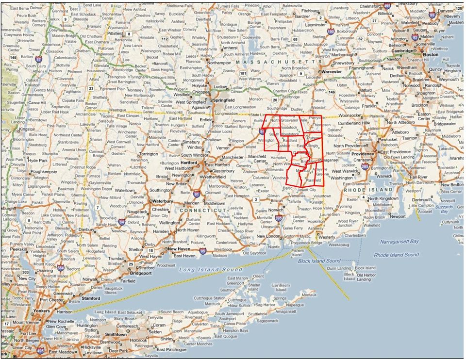
3 Project Background NECCOG Northeastern Connecticut Council of Governments Rural. 12 towns ~500 square miles ~80K pop NECCOG GIS Program Grant Funded Create/Update parcel mapping with most town parcel mapping in poor shape Jurisdictional boundaries inaccurate GPS Trimble GeoXH 2008 and Zephyr Antenna

4
5 GIS Cadastral Data Subcommittee Website: Ultimate Vision Statewide Parcel Dataset Economic Development, Resource Protection, Tax Assessment/Collection, Emergency Management NECCOG a model for Statewide Cadastral Dataset Policy Issues: $$$ Town/State Boundary Issues 169 Towns, Multiple State Agencies, Minimal Federal Involvement Parcel data not just to make assessor tax maps

6 GIS Cadastral Standard Latest Draft dated January _with_draft_watermark.doc Based on MassGIS Parcel Standard, National Cadastral Standard, IAAO Standards, and many other Production and Publication components Focused on Local data management Implementation guidelines being developed

7 GIS Accuracy Requirements Best source available Best methods as appropriate Parcel boundaries via COGO if available Surveys filed with town clerks CT DOT ROW & Railroad Valuation Maps 2004 State of Connecticut B&W Orthoimagery Map Scale and Accuracy The scale of the accuracy of imagery, data and products meets horizontal National Map Accuracy Standards (NMAS) for 200 scale mapping. The ground resolution for this imagery is 0.8 feet per image pixel. Use Basemap used in the identification and location of lines of occupation (stonewalls, fences, landscape changes, etc) that are used in the placement and rotation of unreferenced and/or uncoordinated surveys. Also used to digitize boundaries without COGO source based on lines of occupation USGS/NGA/State of CT available 2012 Not producing survey but using survey sources when available.
 that are used in the placement and rotation of unreferenced and/or")
8 Why GPS? Personal experience Jurisdictional boundary issues Existing parcel mapping overlap/gaps No authoritative jurisdictional boundaries Numerous varying sources Most used from 1:24,000 USGS Topos (DLG s) Extensive State ROW & RR Valuation mapping Some tied to state plane coordinates Rural not much development along state roads
 Extensive State ROW & RR Valuation")
9

10
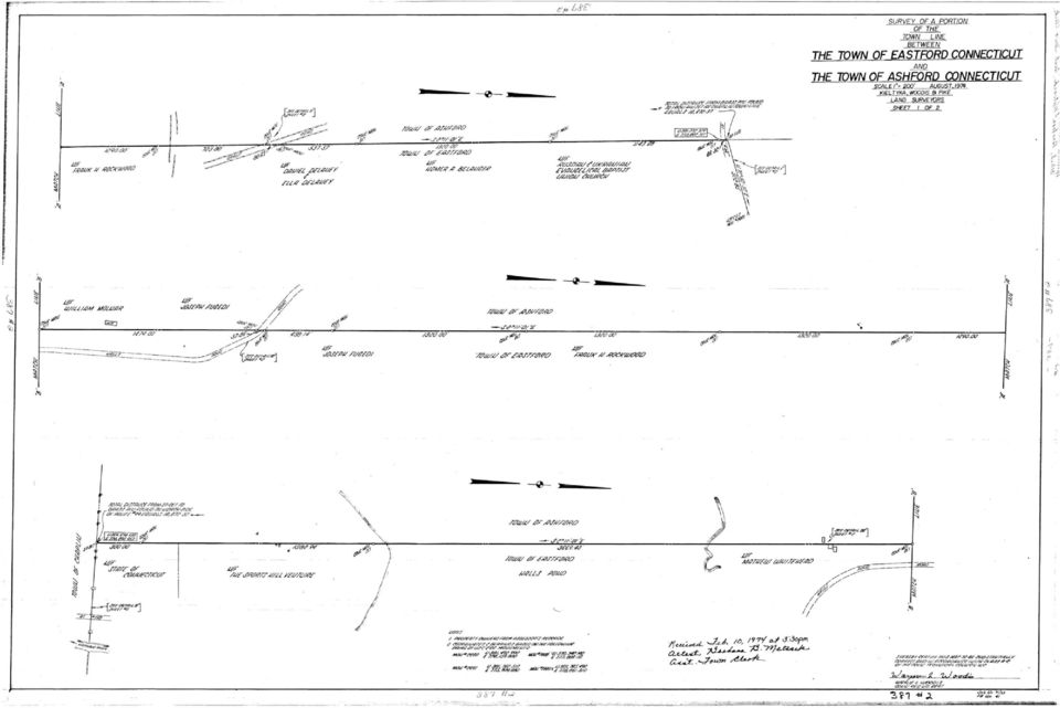
11

12
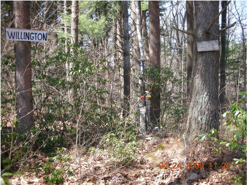
13 NECCOG GPS GIS Data Town Boundary Monuments Material Height Condition Photos CT DOT ROW Monuments Anything else while looking for above

14 NECCOG GPS Software ESRI GIS data centric approach Trimble GPS Analyst ESRI ArcGIS extension GPSCorrect with ESRI ArcPad Workflow Single GPS enabled geodatabase to manage Export data to ArcPad Forms created from data structure pick lists, etc. Field data collection Import data from ArcPad options to review GPS features Post processing Copy/Paste to Enterprise GIS dataset

15 Trimble GeoXH 2008 Trimble Handheld All in one, Windows Mobile, Bluetooth, WiFi GPS/SBAS with L1/L2 internal antenna Ability to connect to external antenna Zephyr H Star Technology Multipath rejection Consistent sub foot post processed accuracies in ideal conditions WiFi enabled Camera link photos to features

16 GeoXH Accuracy Statements Current Equivalent GeoXH 3000: / G_GeoXH%203000%20Series_DS_0211_MGIS_lr.pdf GeoXH 2008 GeoXH 3000

17 Differential Corrections CT DOT CORS Stations Putnam (CTPU) or Mansfield (CTMA) 30 km at most to any point in NECCOG region Use H Star with single station in most locations CT DOT RTK/VRS network in the Future? Future NECCOG project (utilities) Local surveyors plans with NAD83 Coordinates
 Local surveyors plans with NAD83")
18

19 Town Boundary Monument Effort Research town boundaries Maps, Perambulation reports, Town history Pre process Compile survey descriptions, Rotate and best fit, Load into GPS Field Capture Navigate, Locate, Attributes and photos Post process Differential Corrections, Filter out pile of stones Copy monuments to enterprise Cadastral GIS dataset Leave as is if no other location source, move if survey source Boundary features (parcels, town boundaries) to be snapped to town boundary monuments
 to be snapped to town boundary")
20

21
22
23 Raw GPS Points
24 Filtered GPS Points
25 CT DOT ROW s Use CAD if exists Scanned ROW maps otherwise Coordinated maps COGO edwith ROW XY coordinates Non coordinated COGO ed with GPS coordinate Same GPS process as town boundaries ROW lines snapped to selected GPS CHD locations
26
27
28
29
30 Conclusions Using GPS technology as an aid in creating local/regional level Cadastral Data Local/regional Cadastral Data to flow up to State/Federal government Intergovernmental cooperation Local, regional, state and federal Data and resource sharing Derivatives coming soon. Example: Address points
31 Thanks Mark Goetz, GISP GIS Director NECCOG
TOWN OF WESTON,CT REQUEST FOR PROPOSALS. For. Parcel Mapping & Web-Based GIS Application
 TOWN OF WESTON,CT I. INTRODUCTION REQUEST FOR PROPOSALS For Parcel Mapping & Web-Based GIS Application The Town of Weston, Connecticut (the "Town") seeks proposals from interested GIS consultants for the
GEOGRAPHIC INFORMATION SYSTEMS
 GIS GEOGRAPHIC INFORMATION SYSTEMS FOR CADASTRAL MAPPING Chapter 6 2015 Cadastral Mapping Manual 6-0 GIS - GEOGRAPHIC INFORMATION SYSTEMS What is GIS For a long time people have sketched, drawn and studied
GEOGRAPHIC INFORMATION SYSTEMS
 GIS GEOGRAPHIC INFORMATION SYSTEMS FOR CADASTRAL MAPPING Chapter 7 2015 Cadastral Mapping Manual 7-0 GIS - GEOGRAPHIC INFORMATION SYSTEMS What is GIS For a long time people have sketched, drawn and studied
Vermont GIS Parcel Data Standard
 VT Center for Geographic Information Vermont GIS Parcel Data Standard Version 1.1 Release Date: November 2013 Acknowledgements This data standard was drafted by staff at the VT Center for Geographic Information
Subdivision Mapping: Making the Pieces Fit David P. Thaler, GIS Analyst A geographit White Paper, June 2009
 Subdivision Mapping: Making the Pieces Fit P David P. Thaler, GIS Analyst A geographit White Paper, June 2009 1525 Oregon Pike, Suite 202 Lancaster, PA USA 17601-7300 Phone: 717-399-7007 Fax: 717-399-7015
GPS: A Primer. presented by Jim Pugh, GISP GIS Project Manager. 2007, EMH&T, Inc.
 GPS: A Primer presented by Jim Pugh, GISP GIS Project Manager GPS: A Primer GPS = Global Positioning System 24 Satellites in Orbit around Earth Each Broadcasts precise time and known location Receivers
1. We assume the mentioned inaccuracies refer to the at least one foot in ten thousand standard described in point three.
 RFQ GIS Parcel Boundary Correction Services BD 2015-035 Questions and Answers December 31st December 10 th 1. We assume the mentioned inaccuracies refer to the at least one foot in ten thousand standard
Esri s ArcPad vs. ArcGIS Mobile vs. Trimble s TerraSync vs. TerraFlex Comparison By: Electronic Data Solutions
 Esri s ArcPad vs. ArcGIS Mobile vs. Trimble s TerraSync vs. TerraFlex Comparison By: Electronic Data Solutions ArcPad is mobile field mapping and data collection software designed for GIS professionals.
Standard on Digital Cadastral Maps and Parcel Identifiers
 Standard on Digital Cadastral Maps and Parcel Identifiers APPROVED JULY 2003 INTERNATIONAL ASSOCIATION OF ASSESSING OFFICERS 1. Scope This standard provides recommendations on the development and maintenance
Appendix C: Geographic Information Systems (GIS) Sources, Technical Notes and Additional Maps
 Sources, Technical Notes and Additional Maps") Appendix C: Geographic Information Systems (GIS) Sources, Technical Notes and Additional Maps Geographic Information Systems (GIS) The maps and three-dimensional representations contained in this report
Appendix C: Geographic Information Systems (GIS) Sources, Technical Notes and Additional Maps Geographic Information Systems (GIS) The maps and three-dimensional representations contained in this report
GeoExplorer 2008 Series GeoXH Handheld: FAQs for Customers
 7 December 2009 GeoExplorer 2008 Series GeoXH Handheld: FAQs for Customers This document provides information that is common to all models of handheld in the Trimble GeoExplorer 2008 series, followed by
MD imap 2.0 THE NEXT GENERATION OF MARYLAND S ENTERPRISE GIS. Esri MUG Conference Baltimore, MD December 3, 2014 http://imap.maryland.
 THE NEXT GENERATION OF MARYLAND S ENTERPRISE GIS MD imap 2.0 Matt Sokol, GISP Senior GIS Analyst Maryland Department of Information Technology Geographic Information Office Julia Fischer, GISP Senior GIS
ABSTRACT Utilizing Mobile GIS for Hydrology and Hydraulics Field Reconnaissance
 ABSTRACT Utilizing Mobile GIS for Hydrology and Hydraulics Field Reconnaissance Jessica D. Baker 1, EIT, CFM and Noelle Gaspard 1, CFM Advances in technology have dramatically improved traditional methods
INSTRUCTIONS FOR MAKING 3D,.DWG CONTOUR LINES
 INSTRUCTIONS FOR MAKING 3D,.DWG CONTOUR LINES A TUTORIAL FROM SPATIAL AND NUMERIC DATA SERVICES NICOLE SCHOLTZ AND GEOFF IVERSON Overview... 2 A. Get a Digital Elevation Model (DEM)... 3 B. Open ArcMap,
http://www.esri.com/bia
 ArcGIS for Tribal Transportation Management David Gadsden Federal Account Manager dgadsden@esri.com d d 1 David Gadsden GIS Background UW Geography (1995) Peace Corps Tanzania Environmental Social Science
Funding Connecticut s Statewide GIS Program
 Business Plan for: Funding Connecticut s Statewide GIS Program Developed for the: State of Connecticut Geospatial Information System Council (CGISC) October 4, 2007 www.appgeo.com 48 Purnell Place, Suite
National Register of Historic Places: GIS Webinar Cultural Resource GIS Facility National Park Service June 2012
 National Register of Historic Places: GIS Webinar Cultural Resource GIS Facility National Park Service June 2012 In February and March 2012 the National Register of Historic Places held webinars in conjunction
Town of Somers, Connecticut Geographic Information Consulting Services Request for Proposals
 Town of Somers, Connecticut Geographic Information Consulting Services Request for Proposals The Town of Somers invites proposals for Geographic Information System consultation/ implementation services.
Introduction to GIS. http://libguides.mit.edu/gis
 Introduction to GIS http://libguides.mit.edu/gis 1 Overview What is GIS? Types of Data and Projections What can I do with GIS? Data Sources and Formats Software Data Management Tips 2 What is GIS? 3 Characteristics
North Carolina Statewide Orthoimagery 2010 Final Report
 North Carolina Statewide Orthoimagery 2010 Final Report Prepared for: The City of Durham and The North Carolina 911 Board Prepared by: North Carolina Center for Geographic Information and Analysis September
ArcPad a new tool for Asset Inventory/Management at Nevada DOT. Eric Warmath GIS Program Manager, NDOT
 ArcPad a new tool for Asset Inventory/Management at Nevada DOT Eric Warmath GIS Program Manager, NDOT Topics Historical Data Collection Methods Current Methodology Operator Safety Issues Add on Technologies
A. System. City of Perrysburg, Ohio URISA EXEMPLARY SYSTEMS IN GOVERNMENT AWARD
 A. System 1. Name of System and ESIG Category Single Process System Sidewalk Maintenance and Repair Tracking application 2. Letter from the Executive Administrator See Appendix A 3. One Page Summary Every
Understanding Raster Data
 Introduction The following document is intended to provide a basic understanding of raster data. Raster data layers (commonly referred to as grids) are the essential data layers used in all tools developed
Benefits of Mobile GIS for Public Works
 Benefits of Mobile GIS for Public Works Freese and Nichols, Inc. NCAFPM 2013 Agenda General GIS Concepts Mobile GIS Overview Benefits of Mobile GIS Mobile GIS Project Examples Questions What is GIS? Geographic
Remote Sensing, GPS and GIS Technique to Produce a Bathymetric Map
 Remote Sensing, GPS and GIS Technique to Produce a Bathymetric Map Mark Schnur EES 5053 Remote Sensing Fall 2007 University of Texas at San Antonio, Department of Earth and Environmental Science, San Antonio,
Guide to Viewing Maps in Google Earth
 Guide to Viewing Maps in Google Earth The BCT made the decision to provide the GIS (Geographic Information System) resources for Bat Groups in the form of Google Earth maps because they do not require
Creating a File Geodatabase
 Creating a File Geodatabase Updated by Thomas Stieve January 06, 2012 This exercise demonstrates how to create a file geodatabase in ArcGIS 10; how to import existing data into the geodatabase, and how
Extending Enterprise GIS Into The Field with Mobile GIS Technology
 Extending Enterprise GIS Into The Field with Mobile GIS Technology A White Paper January 10, 2014 1525 Oregon Pike Suite 202 Lancaster, PA 17601-7300 Phone (717) 399-7007 Fax (717) 399-7015 www.geographit.com
Geographic Information System Product Distribution Policies. Preface
 Support Services Department Information Technologies Division Geographic Information System Product Distribution Policies Preface 1. Purpose Geographic Information System (GIS) Product Distribution Policies
ESRI Experience in the Use of GIS for Census Mapping Applications
 United Nations Statistical Division Workshop on Census Mapping with GIS ESRI Experience in the Use of GIS for Census Mapping Applications Pieter van Jaarsveld (GIMS) And Peter Kelly (Kelly + Kelly) kenna@kellyandkelly.co.zm
Adjusting GIS Data to the GCDB
 Best Practice Recommendations Adjusting GIS Data to the GCDB Montana Base Map Service Center August 2008 This document was prepared for the State of Montana GIS Base Map Service Center, by DJ&A, P.C. in
Minnesota State Plan Review Level 2 Hazus-MH 2.1 County Model for Flooding Dakota County Evaluation
 Overview Minnesota State Plan Review Level 2 Hazus-MH 2.1 County Model for Flooding Dakota County Evaluation Minnesota Homeland Security and Emergency Management (HSEM) is responsible for supporting activities
GIS Solutions for FTTx Design. David Nelson, GISP
 GIS Solutions for FTTx Design David Nelson, GISP Telecom GIS Manager, Black & Veatch Agenda Intro to GIS Telecom GIS Vision GIS Strategy Project Execution Mobile Online Services Dashboards Client Deliverables
SAMPLE: DO NOT COMPLETE
 EXP: EXPERIENCE POINT PROCEDURE Use the EXP-W experience worksheets, EXP-P professional profiles and EXP-S summary sheet to document your GIS professional experience. The Experience Schedule (next page)
NJDEP GPS Data Collection Standards For GIS Data Development
 NJDEP GPS Data Collection Standards For GIS Data Development Bureau of Geographic Information Systems Office of Information Resource Management June 8, 2011 1.0 Introduction... 3 2.0 GPS Receiver Hardware
Mehmet Secilmis, GISP Environmental Engineer/GIS Specialist Dewberry Parsippany, NJ msecilmis@dewberry.com
 Bridge Inventory Using GIS City of New Haven, CT Mehmet Secilmis, GISP Environmental Engineer/GIS Specialist Dewberry Parsippany, NJ msecilmis@dewberry.com (973) 576-9640 Introduction City of New Haven
CITY OF SUFFOLK, VIRGINIA GIS DATA DISTRIBUTION AND PRICING POLICY
 CITY OF SUFFOLK, VIRGINIA GIS DATA DISTRIBUTION AND PRICING POLICY 1 The City of Suffolk has invested a large amount of effort into the development of a Citywide Geographic Information System (GIS). The
Making Your Mobile Workforce More Efficient
 ArcGIS for Mobile Making Your Mobile Workforce More Efficient What Is Mobile GIS? Mobile geographic information system (GIS) technology extends GIS beyond the office and allows organizations to make accurate,
Location Referencing for An Asset Management System A State DOT Approach
 Location Referencing for An Asset Management System A State DOT Approach Jack Stickel Alaska Department of Transportation and Public Facilities Traditional Asset Management System Maintenance Management
Subject: Using Google Earth, Google Earth Pro, and Google Maps for FWS activities
 Subject: Using Google Earth, Google Earth Pro, and Google Maps for FWS activities Page 1 of 5 As an FWS employee, can I use Google mapping software or applications to help me with my job? The short answer
ESRI Mobile GIS Solutions Overview. Shane Clarke ESRI
 ESRI Mobile GIS Solutions Overview Shane Clarke ESRI Agenda Overview of mobile GIS ESRI mobile GIS Solutions Selecting a mobile GIS solution Q & A 2 Mobile GIS Overview 3 What is mobile GIS? Extension
Asset Management-Roads / Highways Integrated Road Asset Management System-IRAMS. Abhay Kimmatkar Jt. Managing Director
 Asset Management-Roads / Highways Integrated Road Asset Management System-IRAMS Abhay Kimmatkar Jt. Managing Director CORPORATE OFFICE Nagpur GIS CENTERS Nagpur Mumbai Hyderabad Lucknow DOMESTIC OFFICES
4.03 Vertical Control Surveys: 4-1
 4. HORIZONTAL AND VERTICAL CONTROL 4.01 General: Sufficient horizontal and, if applicable, vertical control surveys shall be established by the Contractor for all photogrammetric mapping purposes. Prior
The advantages of high accuracy GIS field data collection in the Transportation Industry. MGIS Overview Sergio Hernández
 The advantages of high accuracy GIS field data collection in the Transportation Industry. MGIS Overview Sergio Hernández The big question: Where are our assets? Where do we need improvements? WHERE? Where
GIS User Guide. for the. County of Calaveras
 GIS User Guide for the County of Calaveras Written by Dave Pastizzo GIS Coordinator Calaveras County San Andreas, California August 2000 Table of Contents Introduction..1 The Vision.1 Roles and Responsibilities...1
Request For Proposal 2012 Digital Orthophotography
 1. RFP Purpose Request For Proposal 2012 Digital Orthophotography The South Mississippi Aerial Photography (SMAPI) is seeking proposals from qualified firms to acquire color, six-inch for 1 :100 scale
UTM Zones for the US UTM UTM. Uniform strips Scalable coordinates
 UTM UTM Uniform strips Scalable coordinates Globally consistent, most popular projection/coordinate system for regional to global scale geospatial data (i.e. satellite images global scale datasets USGS/EDC)
ENTERPRISE GIS FRAMEWORK. Ian Kidner, GISP GIS Systems Administrator Office of Technical Services
 ENTERPRISE GIS FRAMEWORK Ian Kidner, GISP GIS Systems Administrator Office of Technical Services Agenda Why TIMS What is TIMS Agency Processes Benefits Questions 2 Why TIMS ODOT Mission To provide easy
Development of an Impervious-Surface Database for the Little Blackwater River Watershed, Dorchester County, Maryland
 Development of an Impervious-Surface Database for the Little Blackwater River Watershed, Dorchester County, Maryland By Lesley E. Milheim, John W. Jones, and Roger A. Barlow Open-File Report 2007 1308
Applying High-resolution Satellite Imagery and Remotely Sensed Data to Local Government Applications
 Applying High-resolution Satellite Imagery and Remotely Sensed Data to Local Government Applications Sioux Falls, South Dakota Presentation Prepared by Steven J. Van Aartsen City of Sioux Falls GIS November
CDA Information Technology: Fiber To the Home
 C O E U R D A L E N E T R I B E I N F O R M A T I O N T E C H N O L O GY GIS Program Spring 2014 Volume 1, Issue 1 GIS Program plans for new imagery of Reservation Inside this issue: Fiber to Home 2 WWP
SERVICES THAT MAY ONLY BE PERFORMED BY A NEW JERSEY PROFESSIONAL LAND SURVEYOR
 SERVICES THAT MAY ONLY BE PERFORMED BY A NEW JERSEY PROFESSIONAL LAND SURVEYOR 1. ANY MAP OR PLAN THAT SHOWS: Property Lines. NJSA 45:8-28(e), NJAC 13:40-1.3, 13:40-5.1 Locations of Existing Buildings
Introduction to ArcPad: Mobile GIS. Originally prepared by Gregory Vandeberg, Ph.D. Department of Geography
 Introduction to ArcPad: Mobile GIS Originally prepared by Gregory Vandeberg, Ph.D. Department of Geography Outline Introduction What is ArcPad? What can you do with ArcPad? What do you need to run it?
13/10/2011. Data Integration and Interoperability. Gordon Sumerling & Maree Wilson
 Data Integration and Interoperability Gordon Sumerling & Maree Wilson 1 Agenda Seamless integration between GIS and CAD CAD Support in ArcGIS Using GIS Data in CAD Editing GIS Data in CAD Introduction
Standard on Digital Cadastral Maps and Parcel Identifiers
 Standard on Digital Cadastral Maps and Parcel Identifiers Approved January 2012 International Association of Assessing Officers This standard revises and replaces the July 2003 Standard on Digital Cadastral
GIS Data Discovery Workshop
 Florida Division of Emergency Management 1 GIS Data Discovery Workshop Richard Butgereit GIS Administrator 850-413-9907 richard.butgereit@em.myflorida.com floridadisaster.org/gis Critical Facilities Inventory
WV County GIS Plan Template
 Monongalia County GIS Strategic Plan and WV County GIS Plan Template Final Report July 2004 Prepared by: Kurt Donaldson WV GIS Technical Center Department of Geology and Geography West Virginia University
Making Your Mobile Workforce More Efficient
 ArcGIS for Mobile Making Your Mobile Workforce More Efficient What Is Mobile GIS? Mobile geographic information system (GIS) technology extends GIS beyond the office and allows organizations to make accurate,
The Development and Implementation of a GIS System for Sunde Land Surveying, LLC.
 The Development and Implementation of a GIS System for Sunde Land Surveying, LLC. Ryan R. Bormann 1,2 1 Department of Resource Analysis, Saint Mary s University of Minnesota, Winona, MN 55987. 2 Sunde
Branch of Geospatial Support. GEOSPATIAL TRAINING SCHEDULE APRIL 2015 SEPTEMBER 2015 Version: 27 APRIL 2015
 UNITED STATES DEPARTMENT OF THE INTERIOR BUREAU OF INDIAN AFFAIRS Office of Trust Services Division of Land Titles and Records Branch of Geospatial Support 13922 Denver West Parkway, Building 54, Suite
Table of Contents. Executive Summary...1. Statement of Purpose and Key Terms...3. Strategic Planning Approach and Methodology...6
 Table of Contents Executive Summary...1 Statement of Purpose and Key Terms...3 Strategic Planning Approach and Methodology...6 Current Snapshot of GIS in the Commonwealth...16 A Shared Vision of GIS in
Development of Large-Scale Land Information System (LIS) by Using Geographic Information System (GIS) and Field Surveying
 by Using Geographic Information System (GIS) and Field Surveying") Engineering, 2012, 4, 107-118 http://dx.doi.org/10.4236/eng.2012.42014 Published Online February 2012 (http://www.scirp.org/journal/eng) Development of Large-Scale Land Information System (LIS) by Using
Engineering, 2012, 4, 107-118 http://dx.doi.org/10.4236/eng.2012.42014 Published Online February 2012 (http://www.scirp.org/journal/eng) Development of Large-Scale Land Information System (LIS) by Using
IP-S2 HD. High Definition 3D Mobile Mapping System
 IP-S2 HD High Definition 3D Mobile Mapping System Integrated, turnkey solution High Density, Long Range LiDAR sensor for ultimate in visual detail High Accuracy IMU and DMI Odometry for positional accuracy
Table of Contents Introduction/Background. 1
 Scott County GIS Cadastral Data Conversion Project Request for Proposals September 29, 2006 Table of Contents Introduction/Background. 1 1.1 General Information 1.2 Existing Mapping Summary 1.3 Tax Parcel
Learning about GPS and GIS
 Learning about GPS and GIS Standards 4.4 Understand geographic information systems (G.I.S.). B12.1 Understand common surveying techniques used in agriculture (e.g., leveling, land measurement, building
GIS Spatial Data Standards
 GIS Spatial Data Standards Manatee County, FL GIS Section, Information Services Department TABLE OF CONTENTS I. Introduction 2 A. Purpose 2 B. Reference 2 II. Spatial Reference Information 2 A. Projection:
ADWR GIS Metadata Policy
 ADWR GIS Metadata Policy 1 PURPOSE OF POLICY.. 3 INTRODUCTION.... 4 What is metadata?... 4 Why is it important? 4 When to fill metadata...4 STANDARDS. 5 FGDC content standards for geospatial metadata...5
What is GIS. What is GIS? University of Tsukuba. What do you image of GIS? Copyright(C) ESRI Japan Corporation. All rights reserved.
 ESRI Japan Corporation. All rights reserved.") What is GIS University of Tsukuba Graduate School of Life and Environmental Science April 21 st, 2011 What is GIS? What do you image of GIS? Gas Insulated Switch Groupe Interventional Speciale Geographic
What is GIS University of Tsukuba Graduate School of Life and Environmental Science April 21 st, 2011 What is GIS? What do you image of GIS? Gas Insulated Switch Groupe Interventional Speciale Geographic
Using CAD Data in ArcGIS
 Esri International User Conference San Diego, California Technical Workshops July 27, 2012 Using CAD Data in ArcGIS Jeff Reinhart & Phil Sanchez Agenda Overview of ArcGIS CAD Support Using CAD Datasets
Online Digitizing and Editing of GIS Layers (On-Screen or Head s Up Digitizing)
") Online Digitizing and Editing of GIS Layers (On-Screen or Head s Up Digitizing) 2011 Charlie Schweik, Alexander Stepanov, Maria Fernandez, Lara Aniskoff Note: This work is licensed under the Creative Commons
Online Digitizing and Editing of GIS Layers (On-Screen or Head s Up Digitizing) 2011 Charlie Schweik, Alexander Stepanov, Maria Fernandez, Lara Aniskoff Note: This work is licensed under the Creative Commons
Submitted to: Submitted by: Department of Geology and Mineral Industries 800 NE Oregon Street, Suite 965 Portland, OR 97232
 LIDAR REMOTE SENSING DATA COLLECTION DEPARTMENT OF F GEOLOGY AND MINERAL INDUSTRIES CRATER LAKE, OREGON NOVEMBER 30, 2010 Submitted to: Department of Geology and Mineral Industries 800 NE Oregon Street,
Improving Land Administration in Brazil From Rural to National Cadastre
 Improving Land Administration in Brazil From Rural to National Cadastre Thiago Marra thiago.marra@incra.gov.br Kilder Barbosa kilder.barbosa@bhe.incra.gov.br Eduardo Aguilar de Oliveira (presenter) eduardo.oliveira@mda.gov.br
Evolution of Partnership and the Geospatial Liaison Network at the USGS
 Evolution of Partnership and the Geospatial Liaison Network at the USGS Vicki Lukas September 13, 2012 NSGIC Annual Conference U.S. Department of the Interior U.S. Geological Survey An Abridged History
Property Records Online
 Property Records Online What, Why, How,Who, When? Property Development Continuum Project Scope What this means for our customers? Prototype Demo What? Procure and Install Document Management available
SURVEYING WITH GPS. GPS has become a standard surveying technique in most surveying practices
 SURVEYING WITH GPS Key Words: Static, Fast-static, Kinematic, Pseudo- Kinematic, Real-time kinematic, Receiver Initialization, On The Fly (OTF), Baselines, Redundant baselines, Base Receiver, Rover GPS
GEOGRAPHIC INFORMATION SYSTEMS Lecture 20: Adding and Creating Data
 Adding Existing Data Into ArcGIS - there are many different ways to get data into ArcGIS GEOGRAPHIC INFORMATION SYSTEMS Lecture 20: Adding and Creating Data Add Data - normally we use the Add Data button
Geotechnical Data Sharing and Electronic Data Exchange at Minnesota DOT. Derrick D. Dasenbrock 1, M. ASCE, P.E.
 Geotechnical Data Sharing and Electronic Data Exchange at Minnesota DOT Derrick D. Dasenbrock 1, M. ASCE, P.E. 1 Minnesota Department of Transportation, 1400 Gervais Ave, Maplewood, MN, 55109 USA PH (651)
Survey Ties Guidelines
 North Carolina Board of Examiners for Engineers and Surveyors Survey Ties Guidelines The North Carolina Board of Examiners for Engineers and Surveyors is providing this document to serve as an interpretative
RFP # 2229 South Dakota Statewide GIS and Managed Services In Support of the State NG911 Written Inquiry Responses
 RFP # 2229 South Dakota Statewide GIS and Managed Services In Support of the State NG911 Written Inquiry Responses First Company: General Questions: 1. It appears that LR Kimball and Weston assisted with
AERIAL PHOTOGRAPHS. For a map of this information, in paper or digital format, contact the Tompkins County Planning Department.
 AERIAL PHOTOGRAPHS What are Aerial Photographs? Aerial photographs are images of the land taken from an airplane and printed on 9 x9 photographic paper. Why are Aerial Photographs Important? Aerial photographs
Extracting Aerial Images From GIS Based Ortho Photos Using ArcMap 9
 Extracting Aerial Images From GIS Based Ortho Photos Using ArcMap 9 Tutorial Updated August 2006 CP-208 Plan Preparation Studio - Prof. Elizabeth Macdonald 2 In this tutorial we will learn to extract aerial
Botswana Department of Surveys and Mapping (DSM) Cadastral Information System
 Cadastral Information System") Botswana Department of Surveys and Mapping (DSM) Cadastral Information System Bryson B.H. MOREBODI, Republic of Botswana Key words: Cadastre, GIS, Swedsurvey, Botswana, DSM, Survey. SUMMARY Botswana (DSM)
Botswana Department of Surveys and Mapping (DSM) Cadastral Information System Bryson B.H. MOREBODI, Republic of Botswana Key words: Cadastre, GIS, Swedsurvey, Botswana, DSM, Survey. SUMMARY Botswana (DSM)
Mobile 360 Degree Imagery: Cost Effective Rail Network Asset Management October 22nd, 2015. Eric McCuaig, Trimble Navigation
 Mobile 360 Degree Imagery: Cost Effective Rail Network Asset Management October 22nd, 2015 Eric McCuaig, Trimble Navigation The debate: Point Clouds vs. Imagery Both are useful pick the right tool for
SECTION 01 78 29 AS-BUILT DOCUMENTATION
 SECTION 01 78 29 AS-BUILT DOCUMENTATION PART 1: GENERAL 1.01 AS-BUILTS Where identified as a product of the Work, provide as-built drawings adhering to the criteria provided here and in the special conditions.
Regional Basemap Committee
 Regional Basemap Committee Minutes Wednesday ~ ~ 2:00 P.M. Washoe County Administration Engineering Conference Room 1001 East Ninth Street, Reno, Nevada MEMBERS Gary Beekman, Chair Valerie Johnson, Vice-chair
Chapter 6: Data Acquisition Methods, Procedures, and Issues
 Chapter 6: Data Acquisition Methods, Procedures, and Issues In this Exercise: Data Acquisition Downloading Geographic Data Accessing Data Via Web Map Service Using Data from a Text File or Spreadsheet
Enterprise GIS Business Plan July 4, 2008
 Office for Information Resources GIS Services Enterprise GIS Business Plan July 4, 2008 VERSION 1.1 Table of Contents 1 Executive Summary... 3 2 Background... 6 2.1 Tennessee Base Mapping Program... 6
Sharing GIS to AEC users online and on the road
 2014 AEC Summit Sharing GIS to AEC users online and on the road Renato Salvaleon Land Department, Georgia Power Company SCOPE OF PRESENTATION Intro Solution Documents and Geospatial Data Meaningful Information
Why is pre-processing necessary? Overall steps of this workflow: Batch RAW to DNG with Adobe Digital Negative (DNG) Converter Software
 Converter Software") http://gmv.cast.uark.edu A Method Store for Advanced Survey and Modeling Technologies Mon, 01 Apr 2013 03:29:18 +0000 en-us hourly 1 http://wordpress.org/?v=3.5.1 http://gmv.cast.uark.edu/photogrammetry/software-photogrammetry/photomodeler/workflowphotomodeler/pre-processing-digital-images-for-close-range-photogrammetry-crp/
http://gmv.cast.uark.edu A Method Store for Advanced Survey and Modeling Technologies Mon, 01 Apr 2013 03:29:18 +0000 en-us hourly 1 http://wordpress.org/?v=3.5.1 http://gmv.cast.uark.edu/photogrammetry/software-photogrammetry/photomodeler/workflowphotomodeler/pre-processing-digital-images-for-close-range-photogrammetry-crp/
Even Cowboys Need Good Data City of Pendleton GIS Development
 Even Cowboys Need Good Data City of Pendleton GIS Development Presenters: Bob Patterson, P.E., City of Pendleton David Stangel, P.E., Murray, Smith & Assoc. Inc. Project Overview Create GIS Databases for
PHASE 2_3 RD SESSION REPORT KU GIS LABS ARCGIS TRAINING: USING ARCGIS (APPLICATIONS) 18 TH - 22 ND AUGUST 2014 SCHOOL OF ENGINEERING COMPUTER LAB
 18 TH - 22 ND AUGUST 2014 SCHOOL OF ENGINEERING COMPUTER LAB") PHASE 2_3 RD SESSION REPORT KU GIS LABS ARCGIS TRAINING: USING ARCGIS (APPLICATIONS) 18 TH - 22 ND AUGUST 2014 SCHOOL OF ENGINEERING COMPUTER LAB PHASE 2_3 rd SESSION REPORT ARCGIS TRAINING: 18 TH - 22
PHASE 2_3 RD SESSION REPORT KU GIS LABS ARCGIS TRAINING: USING ARCGIS (APPLICATIONS) 18 TH - 22 ND AUGUST 2014 SCHOOL OF ENGINEERING COMPUTER LAB PHASE 2_3 rd SESSION REPORT ARCGIS TRAINING: 18 TH - 22
Title 10 DEPARTMENT OF NATURAL RESOURCES Division 35 Land Survey Chapter 1 Cadastral Mapping Standards
 Title 10 DEPARTMENT OF NATURAL RESOURCES Division 35 Land Survey Chapter 1 Cadastral Mapping Standards 10 CSR 35-1.010 Application of Standards PURPOSE: These minimum standards provide the digital mapper
Introduction to Imagery and Raster Data in ArcGIS
 Esri International User Conference San Diego, California Technical Workshops July 25, 2012 Introduction to Imagery and Raster Data in ArcGIS Simon Woo slides Cody Benkelman - demos Overview of Presentation
A GIS helps you answer questions and solve problems by looking at your data in a way that is quickly understood and easily shared.
 A Geographic Information System (GIS) integrates hardware, software, and data for capturing, managing, analyzing, and displaying all forms of geographically referenced information. GIS allows us to view,
Using GIS to Develop a Control Map and Database
 PENN STATE UNIVERSITY Using GIS to Develop a Control Map and Database SUR-351 Geodetic Models Brian E. Halchak & Rich Cebrick 12/2/2013 Table of Contents Abstract... 2 What is a GIS?... 2 Development of
About As. In a team with the best. ESRI Bulgaria is the exclusive distributor of Esri Inc. for Bulgaria. Esri Inc.
 About As ESRI Bulgaria is an IT company, leader in the field of Geographic Information Systems (GIS) on the Bulgarian market. Offering the most advanced high-tech products, solutions and services, ESRI
Updation of Cadastral Maps Using High Resolution Remotely Sensed Data
 International Journal of Engineering and Advanced Technology (IJEAT) Updation of Cadastral Maps Using High Resolution Remotely Sensed Data V. V.Govind Kumar, K. Venkata Reddy, Deva Pratap Abstract:A cadastral
SUWANNEE RIVER WATER MANAGEMENT DISTRICT REQUEST FOR PROPOSAL NO. 11/12-001MS GEOGRAPHIC INFORMATION SYSTEMS CONSULTING SERVICES.
 SUWANNEE RIVER WATER MANAGEMENT DISTRICT REQUEST FOR PROPOSAL NO. 11/12-001MS GEOGRAPHIC INFORMATION SYSTEMS CONSULTING SERVICES Table of Contents Section Title Page 1 Introduction 2 2 Proposed Schedule
GIS Architecture and Data Management Practices Boone County GIS Created and Maintained by the Boone County Planning Commission GIS Services Division
 GIS Architecture and Data Management Practices Boone County GIS Created and Maintained by the Boone County Planning Commission June 2008 Background Boone County s GIS program has been in existence for
Mount Laurel Township MUA Hydrant Maintenance Program. Using ArcPad to Track Hydrant Flow Testing and Flushing procedures
 Mount Laurel Township MUA Hydrant Maintenance Program Using ArcPad to Track Hydrant Flow Testing and Flushing procedures What is the Mount Laurel MUA? The Mount Laurel Township, Municipal Utilities Authority