A. Deep-Water Waves. 1. Wave Speed (S) = wavelength (L) meters wave period (T) seconds. OCE-3014L Lab 7 Waves & Longshore Currents
|
|
|
- Samson May
- 7 years ago
- Views:
Transcription
1 A. Deep-Water Waves If the water depth (d) is greater then the wave base (equal to one-half the wavelength, or L/2), the waves are called deep-water waves. Deep-water waves have no interference with the ocean bottom, so they include all wind-generated waves in the open ocean. Submarines can avoid large ocean waves by submerging below the wave base. 1. Wave Speed (S) = wavelength (L) meters wave period (T) seconds Wave Length (m) Wave Period (s)* Wave Speed (m/s) * Typical wave periods range between 6 and 16 seconds The longer the wave the longer or the shorter the period? (CIRCLE) Deep water wave speed depends only on wavelength: The longer the wave the faster the slower the speed? (CIRCLE) 1
 = wavelength (L) meters wave period (T) seconds Wave Length (m) Wave Period (s)* Wave Speed (m/s) 100 8 156 10 200 11 400 16 * Typical wave periods range between 6")
2 2. Wave Height: Go to the website below and click on Make Waves Then Click Make Waves Adjust wavelength and period to create the tallest waves. What adjustments create the highest waves? Energy imparted by the wind increases the height, length, and speed of a wave. When wave speed equals wind speed, neither wave length nor wave height can change because there is no net energy exchange and the wave has reached its maximum size, this is called a fully developed sea. Factors that determine the amount of energy in waves are 1) wind speed, 2) the duration length of time wind blows in one direction, and 3) fetch the distance over which the wind blows in one direction. One knot/hour = 1.85 km/hr. 3. 2

3 4. A storm is raging in the North Atlantic 2000 nautical miles due east from Cocoa Beach, Florida. The fetch of the storm (the distance of the open ocean that its winds are whipping up) is roughly 1000 nautical miles. Low pressure winter weather conditions are such that the winds are from the east. Refer to the table above interpolating the fetch distance to determine the wind speed to set up a fully developed sea. knots km/hour How long must the east winds blow for a fully developed sea? hours B. Swells The North Atlantic storm (above) was strong enough to whip up waves that slam into each other. If enough waves come together, their energy will create swell that can travel fast enough and far enough to survive a trip around the globe. Along the way, the less energetic, choppy elements of the wave will be lost and smooth glassy faced swell waves will arrive along Florida s east coast. Swell: Waves that have traveled a long distance from the generating area and have been sorted out by travel into long waves of the same approximate period, which may range between 12 and 24 seconds (longer than that of typical waves). The first swell arrives offshore encountering a water depth less than one-half its wavelength; it feels bottom encountering frictional drag along the bottom. The energy of the wave is compressed causing the crest of the wave to grow taller. It also slows down the bottom of the wave slows down first, meaning the crest of the wave is traveling faster, overrunning the bottom part. The net result is the wave starts to peak increasing its steepness H/L. When wave steepness reaches a 1:7 ratio, the wave can no longer maintain its shape and spills out its energy in a few seconds by breaking on or near the beach. 5. Increases or Decreases? Choose the correct answer for the 4 blanks below. As waves come into shallow water and feel bottom Wavelength Wave Speed Wave Height Wave Steepness 6. Use the internet to access the following site: The image is an animation of the significant wave height for the Pacific Ocean over the next 120 hours (5 days), viewed in 6-hour intervals. Storm centers are shown as areas of high waves. List today s date Are most storms located in the northern or southern hemisphere? What season is it in that hemisphere? Describe location of any storm centers (be specific) In which direction are they moving? What is the height of the highest wave? Ft. 3
 was strong enough to whip up waves that slam into each other.")
4 C. Surf Zone Breakers 6. Calculate the wavelength of breaking waves. Wave Height * (Ft.) Reference height: adult standing in surf zone* Breaking Wave s Wavelength (Ft) 3 Waist 5 Head 7 Overhead 10 Double Overhead * The measurements above are facing the breaking wave. In Hawaii waves are traditionally measured from the back (seaward) side. 1) Along the East Coast of the U.S. the prevailing Westerlies blow off shore, while along the West Coast Westerlies blow onshore enhancing waves. 2)The Pacific Ocean has a greater expanse than the Atlantic Ocean. This means that the fetch (the distance over which the wind blows) is greater on the West Coast than on the East Coast. 3) The West Coast s continental shelf is narrower than the broad gently sloping shelf along the East Coast which has a slowing effect on waves a much greater distance from land. On the West Coast, the shelf rises suddenly near the coast, so the waves are much larger when they crash into the coastline and feel bottom. 7. Hawaiian Waves Powerful North Pacific winter storms send monster swells to crash on Oahu s north shore. Considering the conditions in the figure above and considering that the Hawaiian Islands are all oceanic volcanoes, what factors might contribute to thirty foot waves arriving on Hawaii s north coast? 4
The Pacific Ocean has a greater expanse than the Atlantic Ocean.")
5 Wave types from a surfing perspective a. Spilling Breakers, long life span give surfers a long, if unchallenging ride. b. Plunging pipeline Breakers. Ultimate surfing challenge. Curling crest outruns the wave creating an air pocket tube. c. Collapsing breakers- break irregularly offshore. Large waves can provide short rides where the skill is cutting-out backside before they crash rather than length of ride. d. Surging breakers build up wall-like breaking almost onshore in very shallow water. 8.. Sketch in ocean bottom slopes for each of the four wave types in the boxes above Start your profile to where waves begin to feel bottom to shoreline. 8. The height of a breaker is approximately 0.78 of its depth; thus, a breaker 7.8 feet high would occur in water 10 feet deep. A sport fishing pier is planned for a resort on the west coast of Mexico with the intent of setting pilings in water 20 feet deep at mean high tide. Waves along this stretch of the Mexican Coast have reached heights just under 15 feet. How high would you recommend that the pier be engineered? If you want to get the contract you have to be the lowest bidder. Show work. 5

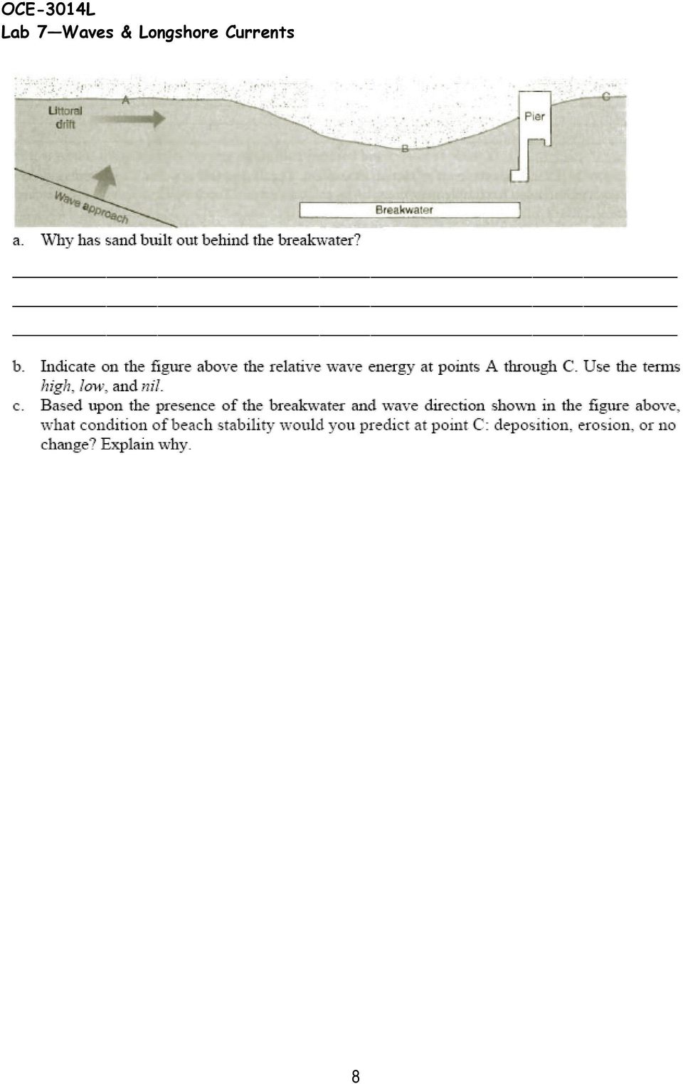
6 D. Longshore Currents & Littoral Drift As a rule, waves approach the shoreline at an angle and are refracted**; however, refraction is incomplete. The swash is the water from the wave that travels on shore at the same angle as the wave approach, expending the last of the wave energy. The backwash is the water that flows back into the ocean; gravity alone powers the backwash, so there is a zigzag path between swash and backwash which establishes a weak longshore current that transports water parallel to the shoreline (Fig.10). The longshore is capable of moving sand along the beach, a process known as beach drift or longshore transport. The earth material transported along the beach is called littoral drift. **Refraction: waves bend to conform to the shape of coastline. This process begins as they begin to feel bottom and they bend to follow the contoured shape of the sea floor offshore. 10. Coastal stabilization structures protect property from wave erosion and protect loss of sand from beaches. Such structures disrupt longshore transport. The littoral drift (sand) builds up on the upstream side of structures, eroding sand from the downstream side of structures (groins and jetties). In Figure 10 draw a groin in the middle of the beach; then sketch in where sand will build up and where the beach will begin to erode. Which side of the groin will you build your beach house? North South Figure What is the direction of longshore transport of littoral drift below? Indicate with an arrow. How did you determine this? 6
. The longshore is capable of moving sand along the beach, a process known as beach drift or longshore transport.")
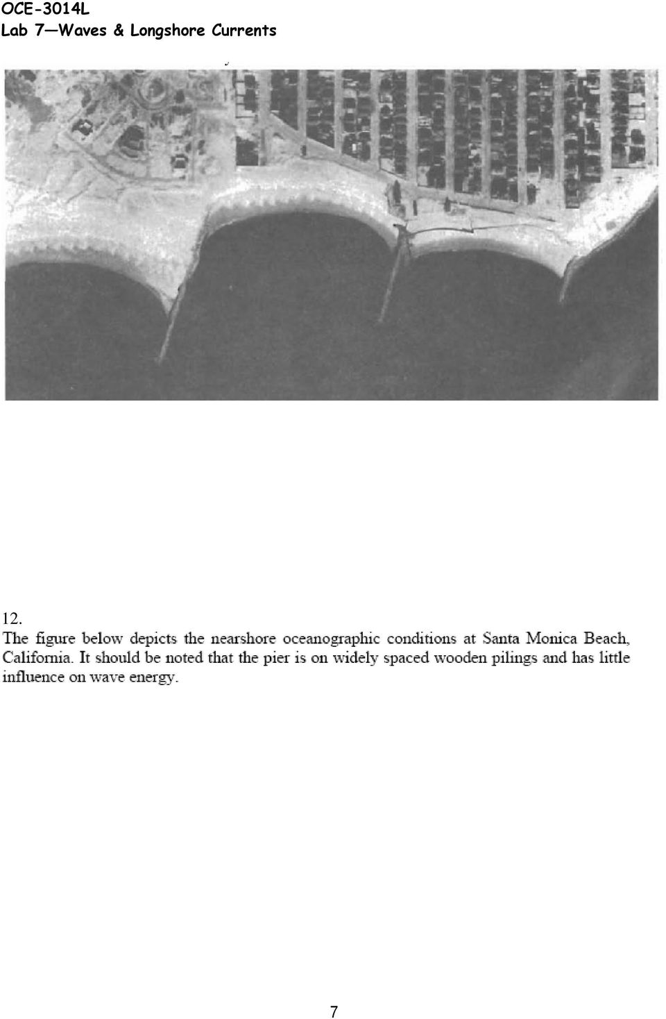
7 12. 7
8 8
Waves disturbances caused by the movement of energy from a source through some medium.
 Oceanography Chapter 10 Waves disturbances caused by the movement of energy from a source through some medium. Floating Gull- Figure 10.1 water is not moving only the energy is moving through the water.
COASTAL DAMAGE INSPECTION SOUTHWEST VITI LEVU, FIJI AFTER CYCLONE SINA
 COASTAL DAMAGE INSPECTION SOUTHWEST VITI LEVU, FIJI AFTER CYCLONE SINA Brendan J. Holden SOPAC Technical Secretariat July 1992 SOPAC Technical Report 148 Prepared for: South Pacific Applied Geoscience
ebb current, the velocity alternately increasing and decreasing without coming to
 Slack water (slack tide): The state of a tidal current when its velocity is near zero, especially the moment when a reversing current changes its direction and its velocity is zero. The term is also applied
SITE INVESTIGATIONS OF THE BEACH EROSION PROBLEM AT MAHO BEACH, ST. MAARTEN
 SITE INVESTIGATIONS OF THE BEACH EROSION PROBLEM AT MAHO BEACH, ST. MAARTEN Performed February 2003 Performed by: Dr. Lee E. Harris, Ph.D., P.E. Associate Professor of Ocean Engineering & Oceanography
Storm tide is the water level rise during a storm due to the combination of storm surge and the astronomical tide.
 INTRODUCTION TO STORM SURGE Introduction to Storm Surge BOLIVAR PENINSULA IN TEXAS AFTER HURRICANE IKE (2008) What is Storm Surge? Inland Extent Storm surge can penetrate well inland from the coastline.
Storm tide is the water level rise during a storm due to the combination of storm surge and the astronomical tide.
 INTRODUCTION TO STORM SURGE Introduction to Storm Surge National Hurricane Center Storm Surge Unit BOLIVAR PENINSULA IN TEXAS AFTER HURRICANE IKE (2008) What is Storm Surge? Inland Extent Storm surge can
The Coast of Crystal Cove Orange County, California
 The Coast of Crystal Cove Orange County, California by Hany Elwany, Ph.D. Scripps Institution of Oceanography Megan Hamilton, M.Sc. Coastal Environments Robert Robinson Dept. of Parks & Recreation Headwaters
STATUS REPORT FOR THE SUBMERGED REEF BALL TM ARTIFICIAL REEF SUBMERGED BREAKWATER BEACH STABILIZATION PROJECT FOR THE GRAND CAYMAN MARRIOTT HOTEL
 STATUS REPORT FOR THE SUBMERGED REEF BALL TM ARTIFICIAL REEF SUBMERGED BREAKWATER BEACH STABILIZATION PROJECT FOR THE GRAND CAYMAN MARRIOTT HOTEL performed by Lee E. Harris, Ph.D., P.E. Consulting Coastal
Waves. Wave Parameters. Krauss Chapter Nine
 Waves Krauss Chapter Nine Wave Parameters Wavelength = λ = Length between wave crests (or troughs) Wave Number = κ = 2π/λ (units of 1/length) Wave Period = T = Time it takes a wave crest to travel one
Tides and Water Levels
 Tides and Water Levels What are Tides? Tides are one of the most reliable phenomena in the world. As the sun rises in the east and the stars come out at night, we are confident that the ocean waters will
Tsunami Practice Questions and Answers Revised November 2008
 Tsunami Practice Questions and Answers Revised November 2008 1. What happened on 26 December 2004 off the west coast of Sumatra? 2. What is the final estimate of the magnitude of the Sumatra 26 December
2 Wind Erosion and Deposition
 CHAPTER 3 2 Wind Erosion and Deposition SECTION Agents of Erosion and Deposition BEFORE YOU READ After you read this section, you should be able to answer these questions: How can wind erosion shape the
Hurricanes and Storm Surge www.hcfcd.org/tropicalweather
 Hurricanes and Storm Surge www.hcfcd.org High-level winds fl ow outward Strong surface winds spiral inward EYE Calm, sometimes cloudfree, sinking air Air sinks in calm area at the storm s eye THUNDERSTORMS
Storm Surge: A Rising Danger by Andrew M. Dzambo
 Storm Surge: A Rising Danger by Andrew M. Dzambo Citizens of the United States are migrating towards the nation s coasts; according to the U.S. Census Bureau, the U.S. coastal watershed county population
Rapid Changes in Earth s Surface
 TEKS investigate rapid changes in Earth s surface such as volcanic eruptions, earthquakes, and landslides Rapid Changes in Earth s Surface Constant Changes Earth s surface is constantly changing. Wind,
EARTH SCIENCE ACTIVITY #1 Tsunami in a Bottle
 EARTH SCIENCE ACTIVITY #1 Tsunami in a Bottle Grades 3 and Up This activity is one of several in a basic curriculum designed to increase student knowledge about earthquake science and preparedness. The
8/18/2014. Chapter 9: Erosion and Deposition. Section 1 (Changing Earth s Surface) 8 th Grade. Weathering
 8 th Grade. Weathering") Section 1 (Changing Earth s Surface) Weathering the chemical and physical processes that break down rock at Earth s surface Chapter 9: Erosion and Deposition 8 th Grade Mechanical weathering when rock
Section 1 (Changing Earth s Surface) Weathering the chemical and physical processes that break down rock at Earth s surface Chapter 9: Erosion and Deposition 8 th Grade Mechanical weathering when rock
TIDES. 1. Tides are the regular rise and fall of sea level that occurs either once a day (every 24.8 hours) or twice a day (every 12.4 hours).
 or twice a day (every 12.4 hours).") TIDES What causes tides? How are tides predicted? 1. Tides are the regular rise and fall of sea level that occurs either once a day (every 24.8 hours) or twice a day (every 12.4 hours). Tides are waves
TIDES What causes tides? How are tides predicted? 1. Tides are the regular rise and fall of sea level that occurs either once a day (every 24.8 hours) or twice a day (every 12.4 hours). Tides are waves
How Do Oceans Affect Weather and Climate?
 How Do Oceans Affect Weather and Climate? In Learning Set 2, you explored how water heats up more slowly than land and also cools off more slowly than land. Weather is caused by events in the atmosphere.
Developing Ocean Energy in Ireland. Belmullet Wave Energy Test Site
 Developing Ocean Energy in Ireland Belmullet Wave Energy Test Site Where does our energy come from? Most of the energy we use in Ireland comes from fossil fuels such as oil, coal, peat and gas. We burn
Quadrant 1 Sea Breeze: Routing Considerations Table of Contents
 Quadrant 1 Sea Breeze: Routing Considerations Table of Contents Introduction Quadrant 1 Sea Breeze Description 2 3 Introduction Four Sea Breeze Quadrants (Figure 1) When considering a sea breeze and its
ANATOMY OF A MUDSLIDE AND DAMAGE CAUSED BY HURRICANE IVAN
 ANATOMY OF A MUDSLIDE AND DAMAGE CAUSED BY HURRICANE IVAN by Jim Hooper, Fugro-McClelland Marine Geosciences Presented at the Houston Marine Insurance Seminar Westin Galeria Hotel, Houston Texas September
BEACH NOURISHMENT COMBINED WITH SIC VERTICAL DRAIN IN MALAYSIA.
 BEACH NOURISHMENT COMBINED WITH SIC VERTICAL DRAIN IN MALAYSIA. Claus Brøgger 1 and Poul Jakobsen 2 The present paper presents measurements and results from a three year full scale Pilot Project with the
The concepts developed in this standard include the following: Oceans cover about 70% of the surface of the Earth.
 Name Date Grade 5 SOL 5.6 Review Oceans Made by SOLpass - www.solpass.org solpass100@comcast.net Reproduction is permitted for SOLpass subscribers only. The concepts developed in this standard include
Using LIDAR to monitor beach changes: Goochs Beach, Kennebunk, Maine
 Geologic Site of the Month February, 2010 Using LIDAR to monitor beach changes: Goochs Beach, Kennebunk, Maine 43 o 20 51.31 N, 70 o 28 54.18 W Text by Peter Slovinsky, Department of Agriculture, Conservation
Earth Science Chapter 14 Section 2 Review
 Name: Class: Date: Earth Science Chapter 14 Section Review Multiple Choice Identify the choice that best completes the statement or answers the question. 1. Which of the following is NOT one of the three
Ocean Floor Continental Slope Begins at the Continental Shelf Very sharp drop to depths over 2 miles Covered with thick layers of sand, mud, and rocks
 Ocean Floor Continental Shelf Begins at the shoreline Gently slopes underwater Average depth of 430 feet Thick layers of sand, mud, and rocks The beach is part of the Continental Shelf Ocean Floor Continental
Chapter Overview. Bathymetry. Measuring Bathymetry. Echo Sounding Record. Measuring Bathymetry. CHAPTER 3 Marine Provinces
 Chapter Overview CHAPTER 3 Marine Provinces The study of bathymetry charts ocean depths and ocean floor topography. Echo sounding and satellites are efficient bathymetric tools. Most ocean floor features
TECTONICS ASSESSMENT
 Tectonics Assessment / 1 TECTONICS ASSESSMENT 1. Movement along plate boundaries produces A. tides. B. fronts. C. hurricanes. D. earthquakes. 2. Which of the following is TRUE about the movement of continents?
Chapter 7 Earthquake Hazards Practice Exam and Study Guide
 Chapter 7 Earthquake Hazards Practice Exam and Study Guide 1. Select from the following list, all of the factors that affect the intensity of ground shaking. a. The magnitude of the earthquake b. Rather
Hot Spots & Plate Tectonics
 Hot Spots & Plate Tectonics Activity I: Hawaiian Islands Procedures: Use the map and the following information to determine the rate of motion of the Pacific Plate over the Hawaiian hot spot. The volcano
CHAPTER 13 - SEA WAVES AND SURGES
 CHAPTER 13 - SEA WAVES AND SURGES 13.1 Sea waves and swell 13.1.1 Forecasting wind-wave heights and periods 13.1.1.1 Waves in deep water 13.1.1.2 Waves in shallow waters 13.1.2 Wave conditions at the shoreline;
St Lucia. Wise practices for coping with. i b bea n Se a
 Wise practices for coping with St Lucia Car i b bea n Se a Fisheries Department, St Lucia Physical Planning Department, St Lucia University of Puerto Rico, Sea Grant College Program Caribbean Development
What causes Tides? If tidal forces were based only on mass, the Sun should have a tidegenerating
 What are Tides? Tides are very long-period waves that move through the oceans as a result of the gravitational attraction of the Moon and the Sun for the water in the oceans of the Earth. Tides start in
Thompson/Ocean 420/Winter 2005 Tide Dynamics 1
 Thompson/Ocean 420/Winter 2005 Tide Dynamics 1 Tide Dynamics Dynamic Theory of Tides. In the equilibrium theory of tides, we assumed that the shape of the sea surface was always in equilibrium with the
SEAPRO has both foam filled flotation boom and inflatable boom systems.
 BOOMING OPERATIONS SEAPRO Response Operations Manual General Information Booming operations are necessary for the containment and concentration of spilled oil on water. By containing product, potential
http://www.nj.gov/dep/shoreprotection/storm.htmhris TUCKER
 COASTAL STORM SURVEY NEW JERSEY DEPARTMENT OF ENVIRONMENTAL PROTECTION BUREAU OF COASTAL ENGINEERING - TOMS RIVER NJ 12:00 P.M. TUESDAY, MARCH 1, 2005 NEW JERSEY COASTLINE INCLUDING RARITAN AND DELAWARE
7) Coastal Storms: Multi-Hazard Analysis for New York City
 Coastal Storms: Multi-Hazard Analysis for New York City") 7) Coastal Storms: Multi-Hazard Analysis for New York City a) Hazard Profile i) Hazard Description Coastal storms, including nor'easters, tropical storms, and hurricanes, can and do affect New York City.
7) Coastal Storms: Multi-Hazard Analysis for New York City a) Hazard Profile i) Hazard Description Coastal storms, including nor'easters, tropical storms, and hurricanes, can and do affect New York City.
Geography affects climate.
 KEY CONCEPT Climate is a long-term weather pattern. BEFORE, you learned The Sun s energy heats Earth s surface unevenly The atmosphere s temperature changes with altitude Oceans affect wind flow NOW, you
Impacts of Global Warming on North Carolina s Coastal Economy
 Impacts of Global Warming on North Carolina s Coastal Economy IMPACTS OF GLOBAL WARMING ON NORTH CAROLINA S COASTAL ECONOMY Key Findings Global warming is projected to have significant impacts on North
Tropical Storm Debby. Post-Debby Beach/Dune Damage Assessment Report Sarasota Florida. By Weiqi Lin P.E., Ph.D. Coastal Resources/Community Services
 Tropical Storm Debby Post-Debby Beach/Dune Damage Assessment Report Sarasota Florida By Weiqi Lin P.E., Ph.D. Coastal Resources/Community Services June 29, 2012 BACKGROUND AND SUMMARY Tropical storm Debby
SOUTHERN OCEAN CURRENTS. http://www.polar.org/antsun/oldissues2002-2003/sun121502/current.html
 Map from: SOUTHERN OCEAN CURRENTS http://www.polar.org/antsun/oldissues2002-2003/sun121502/current.html FROM: The Antarctic Coastal Current Joanna Gyory, John Cangialosi, Ieng Jo, Arthur J. Mariano, Edward
Name Period 4 th Six Weeks Notes 2015 Weather
 Name Period 4 th Six Weeks Notes 2015 Weather Radiation Convection Currents Winds Jet Streams Energy from the Sun reaches Earth as electromagnetic waves This energy fuels all life on Earth including the
Tropical Storm Debby
 Tropical Storm Debby Post-Debby Beach/Dune Damage Assessment Report (Draft) Sarasota Florida By Weiqi Lin P.E., Ph.D. Coastal Resources/Community Services June 28, 2012 BACKGROUND AND SUMMARY Tropical
Damage Potential of Tropical Cyclone
 Damage Potential of Tropical Cyclone Regional Specialised Meteorological Centre (RSMC)- Tropical Cyclone, New Delhi Cyclone Warning Division India Meteorological Department Mausam Bhavan, Lodi Road, New
When Is an Elephant Not an Elephant? When It's a Seal, Of Course! By Mikki Sadil
 Everyone knows that elephants have trunks. But did you know there is a kind of seal that also has a trunk? This is the elephant seal, which gets its name from the extra large proboscis, or nose, on the
Updated Federal Emergency Management Agency Flood Insurance Rate Maps and Zoning Ordinance Update. July 16, 2015 Policy Committee
 Updated Federal Emergency Management Agency Flood Insurance Rate Maps and Zoning Ordinance Update July 16, 2015 Policy Committee FEMA Map Update Costal Analysis and mapping study by FEMA in 2009 Changes
Earth Science Landforms, Weathering, and Erosion Reading Comprehension. Landforms, Weathering, and Erosion
 Reading Comprehension Name 1 How many people have been to the Rocky Mountains or the Grand Canyon? When people go to visit these natural wonders, they may not realize that it took millions of years for
AQUITAINE COAST (FRANCE)
") AQUITAINE COAST (FRANCE) Contact: Jean Christophe LE BRETON Anne GUCHAN Conseil Regional d Aquitaine 14 Rue François de Sourdis 33077 Bordeaux (CEDEX) 10 Tel: +34 055 757 83 06 Fax: +34 055 656 38 06 e-mail:
AQUITAINE COAST (FRANCE) Contact: Jean Christophe LE BRETON Anne GUCHAN Conseil Regional d Aquitaine 14 Rue François de Sourdis 33077 Bordeaux (CEDEX) 10 Tel: +34 055 757 83 06 Fax: +34 055 656 38 06 e-mail:
CONTAINMENT BOOM OBJECTIVE & STRATEGY TACTIC DESCRIPTION. Mechanical Recovery Containment and Recovery
 Mechanical Recovery Containment and Recovery CONTAINMENT BOOM OBJECTIVE STRATEGY ing is a fixed- tactic. The objective is to corral spilled oil on the water, usually near the source, thus minimizing spreading
Illinois Coastal Management Program 2011
 4 Coastal Erosion Assessment and Planning The Lake Michigan coast is a dynamic setting influenced by waves, ice, and changing lake levels. The potential for coastal erosion exists along nearly the entire
Southern AER Atmospheric Education Resource
 Southern AER Atmospheric Education Resource Vol. 9 No. 5 Spring 2003 Editor: Lauren Bell In this issue: g Climate Creations exploring mother nature s remote control for weather and Climate. g Crazy Climate
Small Dam Hazard Assessment Inventory
 Small Dam Hazard Assessment Inventory What would happen if your dam were to fail? This is a question that most dam owners hope they will never have to answer. However it is a question you, as a responsible
Tide - rhythmic oscillation of the ocean surface due to gravitational & centrifugal forces ( inertia ) between the Earth, Moon and Sun.
 between the Earth, Moon and Sun.") Chapter 4: The Changing Level of the Sea Tides Longer Scale Variations Influence on Beaches Tide - rhythmic oscillation of the ocean surface due to gravitational & centrifugal forces ( inertia ) between
Chapter 4: The Changing Level of the Sea Tides Longer Scale Variations Influence on Beaches Tide - rhythmic oscillation of the ocean surface due to gravitational & centrifugal forces ( inertia ) between
How Did These Ocean Features and Continental Margins Form?
 298 10.14 INVESTIGATION How Did These Ocean Features and Continental Margins Form? The terrain below contains various features on the seafloor, as well as parts of three continents. Some general observations
Chapter 3: Weather Map. Weather Maps. The Station Model. Weather Map on 7/7/2005 4/29/2011
 Chapter 3: Weather Map Weather Maps Many variables are needed to described weather conditions. Local weathers are affected by weather pattern. We need to see all the numbers describing weathers at many
Chapter 18 Introduction to. A f r i c a
 Chapter 18 Introduction to A f r i c a Ch. 18:1 Landforms & Resources 1. Africa s shape & landforms are the result of its location in the southern part of the ancient supercontinent of. Pangaea Over thousands
SHORELINE STABILIZATION RECOMMENDATIONS FOR PLAYA DEL SECRETO MAYA RIVIERA, Q.R., MEXICO
 SHORELINE STABILIZATION RECOMMENDATIONS FOR PLAYA DEL SECRETO MAYA RIVIERA, Q.R., MEXICO NOVEMBER 2007 PHOTOGRAPH LOOKING SOUTH ALONG PLAYA DEL SECRETO PREPARED BY: Lee E. Harris, Ph.D., P.E. Consulting
ENERGY IN THE OCEAN. Tides, Waves, and Currents. 20.1 The Tides 20.2 Ocean Waves 20.3 Ocean Currents
 ENERGY IN THE OCEAN 20 Tides, Waves, and Currents When you have finished this chapter, you should be able to: EXPLAIN the forces that cause the different kinds of tides. DISCUSS the effects of changing
6. Base your answer to the following question on the graph below, which shows the average monthly temperature of two cities A and B.
 1. Which single factor generally has the greatest effect on the climate of an area on the Earth's surface? 1) the distance from the Equator 2) the extent of vegetative cover 3) the degrees of longitude
Coastal Erosion Risk Mitigation Strategies applied in a Small Island Developing State: The Barbados Model
 Coastal Erosion Risk Mitigation Strategies applied in a Small Island Developing State: The Barbados Model BY Dr. Leo Brewster, Director Coastal Zone Management Unit, Barbados Presented At UNFCCC Expert
Long Island s Dynamic South Shore
 Long Island s Dynamic South Shore A Primer on the Forces and Trends Shaping Our Coast Jay Tanski Long Island s Dynamic South Shore A Primer on the Forces and Trends Shaping Our Coast Introduction Long
Geomorphology is the Study of Landforms. Usually by Erosion, Transportation and Deposition
 Geomorphology is the Study of Landforms and the Processes that t Create Them, Usually by Erosion, Transportation and Deposition Fluvial = running water, rivers and floodplains Glacial = flowing ice in
Plate Tectonics: Ridges, Transform Faults and Subduction Zones
 Plate Tectonics: Ridges, Transform Faults and Subduction Zones Goals of this exercise: 1. review the major physiographic features of the ocean basins 2. investigate the creation of oceanic crust at mid-ocean
RESTORATION AND ENHANCEMENT OF SOUTHERN CALIFORNIA LAGOONS
 RESTORATION AND ENHANCEMENT OF SOUTHERN CALIFORNIA LAGOONS by Hany Elwany, Ph.D. Scripps Institution of Oceanography Headwaters to Oceans Conference 25 October 2003 CE Ref #03-22 San Diego County Lagoons
Exploring Florida: Teaching Resources for Science 1 of 6
 Exploring Florida: Teaching Resources for Science 1 of 6 Tropical Cyclones This document describes tropical cyclones and the dangers they pose to coastal populations. It is intended to help teachers improve
Speed A B C. Time. Chapter 3: Falling Objects and Projectile Motion
 Chapter 3: Falling Objects and Projectile Motion 1. Neglecting friction, if a Cadillac and Volkswagen start rolling down a hill together, the heavier Cadillac will get to the bottom A. before the Volkswagen.
Offshore Alabama Prepared by the University of South Alabama MBA Consulting Group in December 2010
 Offshore Alabama Prepared by the University of South Alabama MBA Consulting Group in December 2010 Executive Summary The Mobile Area Chamber of Commerce s Oil and Gas Task Force (Task Force) was created
User s Guide. Zuniga Point. Point Loma
 User s Guide Welcome to the Location File for San Diego Bay, located in the southwestern corner of the U.S. San Diego Bay has an excellent natural harbor, which has made it a busy commercial port. San
& Q A. on Purchasing Coastal Real Estate in South Carolina. S.C. Sea Grant Extension Program S.C. DHEC/Office of Ocean and Coastal Resource Management
 & Q A on Purchasing Coastal Real Estate in South Carolina S.C. Sea Grant Extension Program S.C. DHEC/Office of Ocean and Coastal Resource Management 1 Questions and Answers on Purchasing Coastal Real Estate
The Mantas of Yap The Rhythm of the Tides Lesson Plan
 The Mantas of Yap The Rhythm of the Tides Lesson Plan In this episode, Jonathan travels to Yap, an island in the Pacific nation of Micronesia, to dive with giant Manta Rays. Manta Rays come to this area
FINAL REPORT FOR 2012 ON THE CONDITION OF THE MUNICIPAL BEACHES IN THE CITY OF BRIGANTINE BEACH, ATLANTIC COUNTY, NEW JERSEY
 FINAL REPORT FOR 2012 ON THE CONDITION OF THE MUNICIPAL BEACHES IN THE CITY OF BRIGANTINE BEACH, ATLANTIC COUNTY, NEW JERSEY Photograph was taken November 3, 2012 from 10 th Street North looking south
PLATE TECTONICS EXERCISE (Modified from North Seattle Community College online exercise)
") PLATE TECTONICS EXERCISE (Modified from North Seattle Community College online exercise) Introduction: As discussed in our textbook, the speed at which tectonic plates move has been calculated in several
PLATE TECTONICS EXERCISE (Modified from North Seattle Community College online exercise) Introduction: As discussed in our textbook, the speed at which tectonic plates move has been calculated in several
WEATHERING, EROSION, and DEPOSITION REVIEW
 WEATHERING, EROSION, and DEPOSITION REVIEW Weathering: The breaking up of rock from large particles to smaller particles. a) This Increases surface area of the rock which speeds the rate of chemical weathering.
The Dynamic Crust 2) EVIDENCE FOR CRUSTAL MOVEMENT
 EVIDENCE FOR CRUSTAL MOVEMENT") The Dynamic Crust 1) Virtually everything you need to know about the interior of the earth can be found on page 10 of your reference tables. Take the time to become familiar with page 10 and everything
The Dynamic Crust 1) Virtually everything you need to know about the interior of the earth can be found on page 10 of your reference tables. Take the time to become familiar with page 10 and everything
4.3.5 - Breakaway Walls
 4.3.5 - Breakaway Walls Elevation of a structure on a properly designed foundation reduces the potential for water damage from flooding. When the space below the lowest elevated floor is maintained free
Alfred Wegener s Theory of Continental Drift Became Modern Plate Tectonics. Wegener in Greenland about 1912. He froze to death there in 1930.
 Alfred Wegener s Theory of Continental Drift Became Modern Plate Tectonics Wegener in Greenland about 1912. He froze to death there in 1930. Science is self correcting. The Scientific Method The history
What Causes Climate? Use Target Reading Skills
 Climate and Climate Change Name Date Class Climate and Climate Change Guided Reading and Study What Causes Climate? This section describes factors that determine climate, or the average weather conditions
asbpa Preserving our coastal economy and ecology since 1926
 Preserving our coastal economy asbpa and ecology since 1926 HEALTHY BEACHES ARE VITAL TO OUR WAY OF LIFE People in the United States highly prize the thousands of miles of sandy beaches along our nation
Coastal Risk Management Guide. Incorporating sea level rise benchmarks in coastal risk assessments
 Coastal Risk Management Guide Incorporating sea level rise benchmarks in coastal risk assessments Published by: Department of Environment, Climate Change and Water NSW 59 61 Goulburn Street PO Box A290
How to analyze synoptic-scale weather patterns Table of Contents
 How to analyze synoptic-scale weather patterns Table of Contents Before You Begin... 2 1. Identify H and L pressure systems... 3 2. Locate fronts and determine frontal activity... 5 3. Determine surface
How To Check For Scour At A Bridge
 Case Studies Bridge Scour Inspection and Repair Edward P. Foltyn, P.E. Senior Hydraulic Engineer ODOT Bridge Unit 2013 PNW Bridge Inspectors Conference April 2013 REFERENCES Stream Stability at Highway
Solar PV panels fitted to roofs. Solar PV panels produce electricity from energy provided by sunlight. 3.5 MWh per system
 Solar PV panels fitted to roofs Yearly cost of production Cost per kwh 12.5p Solar PV panels produce electricity from energy provided by sunlight. 3.5 MWh per system 430 per system Solar energy can be
Chapter 3: Weather Map. Station Model and Weather Maps Pressure as a Vertical Coordinate Constant Pressure Maps Cross Sections
 Chapter 3: Weather Map Station Model and Weather Maps Pressure as a Vertical Coordinate Constant Pressure Maps Cross Sections Weather Maps Many variables are needed to described dweather conditions. Local
WEATHERING, EROSION, AND DEPOSITION PRACTICE TEST. Which graph best shows the relative stream velocities across the stream from A to B?
 NAME DATE WEATHERING, EROSION, AND DEPOSITION PRACTICE TEST 1. The diagram below shows a meandering stream. Measurements of stream velocity were taken along straight line AB. Which graph best shows the
Wave & Tidal Energy. Wave and Tidal Energy. What is Wave energy? What is Tidal Energy?
 Wave and Tidal Energy Wave & Tidal Energy Amanda Wright SCI 321u / Gossen A new solution? As non-renewable energy sources, such as coal, are being tapped out, new and innovative ways of creating energy
Earth In Space Chapter 3
 Earth In Space Chapter 3 Shape of the Earth Ancient Greeks Earth casts a circular shadow on the moon during a lunar eclipse Shape of the Earth Ancient Greeks Ships were observed to disappear below the
The success of the hurricane protection around Chevron s refinery at Pascagoula, MS, during Katrina
 The success of the hurricane protection around Chevron s refinery at Pascagoula, MS, during Katrina Dr J.W. van der Meer, Dr C. Cooper, M.J. Warner, H. Adams-Morales and G.J. Steendam Abstract and presentation
Volcanoes and More: A Visit to Two National Parks in Hawaii
 VOA Special English is a daily news and information service for English learners. Read the story and then do the activities at the end. MP3s of stories can be found at voaspecialenglish.com Volcanoes and
c f'f:..-- Risk Identification Branch
 Federal Emergency Management Agency Washington, D.C. 20472 AUG -1 3)05 MEMORANDUM FOR: FROM: c f'f:..-- Risk Identification Branch SUBJECT: Procedure Memorandum No. 37 Protocol for Atlantic and Gulf Coast
Predicting Coastal Hazards: A Southern California Demonstration
 Predicting Coastal Hazards: A Southern California Demonstration Patrick Barnard United States Geological Survey Coastal and Marine Geology Team Santa Cruz, CA Southern California Multi-hazards Demonstration
Report on. Wind Resistance of Signs supported by. Glass Fiber Reinforced Concrete (GFRC) Pillars
 Pillars") Report on Wind Resistance of Signs supported by Glass Fiber Reinforced Concrete (GFRC) Pillars Prepared for US Sign and Fabrication Corporation January, 2006 SUMMARY This study found the attachment of
Report on Wind Resistance of Signs supported by Glass Fiber Reinforced Concrete (GFRC) Pillars Prepared for US Sign and Fabrication Corporation January, 2006 SUMMARY This study found the attachment of
Module 11: The Cruise Ship Sector. Destination #3
 Module 11: The Cruise Ship Sector Destination #3 Cruise Destinations Welcome to your third destination. Use the following resource article to learn about the different oceans and time zones. Seen from
Analysis of the Interstate 10 Twin Bridge s Collapse During Hurricane Katrina
 Analysis of the Interstate 0 Twin Bridge s Collapse During Hurricane Katrina By Genda Chen, Emitt C. Witt III, David Hoffman, Ronaldo Luna, and Adam Sevi The Interstate 0 Twin Span Bridge over Lake Pontchartrain
Investigation 6: What happens when plates collide?
 Tectonics Investigation 6: Teacher Guide Investigation 6: What happens when plates collide? In this activity, students will use the distribution of earthquakes and volcanoes in a Web GIS to learn about
Scour and Scour Protection
 Design of Maritime Structures Scour and Scour Protection Steven A. Hughes, PhD, PE Coastal and Hydraulics Laboratory US Army Engineer Research and Development Center Waterways Experiment Station 3909 Halls
GENERAL SCIENCE LABORATORY 1110L Lab Experiment 9B: Tracking the Hawaiian Islands: How Fast Does the Pacific Plate Move?
 GENERAL SCIENCE LABORATORY 1110L Lab Experiment 9B: Tracking the Hawaiian Islands: How Fast Does the Pacific Plate Move? Background You know that the Earth s crustal plates are always moving, but how fast?
Numerical Modeling Earthquake Effects On Sea Outfall Systems : Kadýköy Sea Outfall Case
 2 ND INTERNATIONAL CONFERENCE ON MARINE WASTE WATER DISCHARGES MWWD 2002 - I STANBUL SEPT. 16 20 Numerical Modeling Earthquake Effects On Sea Outfall Systems : Kadýköy Sea Outfall Case Prof.Dr. Sedat Kabdaþlý
A Few Facts about Antarctica
 A Few Facts about Antarctica Antarctica is the continent that surrounds the South Pole, the southernmost point at the bottom of the earth. Antarctica is a continent because it is land that is covered by
6.E.2.2 Plate Tectonics, Earthquakes and Volcanoes
 Name: Date: 1. The road shown below was suddenly broken by a natural event. 3. The convergence of two continental plates would produce Which natural event most likely caused the crack in the road? island