City of Grande Prairie Development Services Department CENTRE WEST BUSINESS PARK OUTLINE PLAN OP-02-01
|
|
|
- Adam Dickerson
- 7 years ago
- Views:
Transcription
1 City of Grande Prairie Development Services Department CENTRE WEST BUSINESS PARK OUTLINE PLAN OP October 1, 2002

2 Table of Contents 1. 0 INTRODUCTION OBJECTIVES DEVELOPMENT AREA LOCATION OWNERSHIP TOPOGRAPHY EXISTING LAND USE ENVIRONMENTAL ISSUES APPLICABLE PLANS & POLICIES Municipal Development Plan Master Plans Area Structure Plan Land Use Bylaw DEVELOPMENT CONCEPT LOT LAYOUT PROPOSED LAND USE PHASING TRANSPORTATION CIRCULATION INTERSECTIONS TRANSIT SERVICING GENERAL WATER DISTRIBUTION SYSTEM Existing Utilities Flow Requirements Modeling Proposed Piping System and Phasing SANITARY SEWER SYSTEM Existing Utilities Proposed Sewer System & Phasing STORM SEWER SYSTEM Existing Utilities Proposed Catchment Area Proposed Storm Sewer System SHALLOW UTILITIES IMPLEMENTATION PHASING DEVELOPMENT POLICIES CLOSURE... 10

3 LIST OF FIGURES Figure 1 Location Plan Figure 2 Existing Land Use Figure 3 Topographic Plan5 Figure 4 Proposed Lot Layout and Phasing Figure 5 Proposed Land Use Amended OP-02-1B October 15, 2012 Figure 6 Transportation Plan Figure 7 Water Distribution System Figure 8 Sanitary Sewer System Figure 9 Storm Sewer System

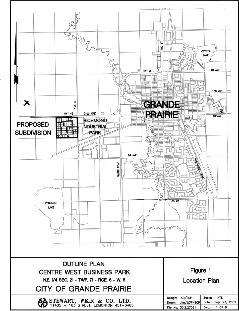
4 Centre West Business Park Outline Plan 1.0 INTRODUCTION 1.1 OBJECTIVES This Outline Plan covers all lands within NE near the west end of the city. The study area lies west of 116 th Street and south of Highway 43 (100 th Avenue). The purpose of this Outline Plan is to provide a description of the existing and proposed land uses and to outline the servicing concepts in accordance with plans and policies adopted by the City of Grande Prairie. The Outline Plan will provide a detailed plan for development and ensure that land use and servicing concepts are congruent with existing adjacent development while incorporating plans for future development. With the Area Structure Plan in place, the Outline Plan serves as the next step towards re-zoning and subdivision. The final design reports have not been accepted on this development at this time. Any assumptions in this outline report in relation to the specifics of the servicing are subject to change as incorporated in the final acceptance of the design reports. Specific objectives of this plan are to: Identify the existing land use for the study area and adjacent developments; Determine existing features that may limit or place restrictions on development; Describe the proposed land use and phasing; and Provide a general outline of the servicing concepts that reflect the findings of the detailed design and supplementary reports. 2.0 DEVELOPMENT AREA 2.1 LOCATION The development area (NE ) is located on the west side of the City and is bounded on the north by Highway 43 (100 th Ave) and to the east by 116 th Street. The gross developable area is hectares. Figure 1 shows the development boundaries. The City of Grande Prairie Page 1

5 Centre West Business Park Outline Plan 2.2 OWNERSHIP The entire area included in this Outline Plan is owned by Alberta Ltd. 2.3 TOPOGRAPHY The land is relatively flat with a slight slope towards the southeast. The overall slope averages approximately 0.2%. There are no water bodies contained within the proposed development area. A topographic map is shown on Figure EXISTING LAND USE Most of the area is currently farmed with a small portion occupied by an abandoned homestead. The land is designated as Urban Reserve. The development area is bounded on the north by the airport and agricultural land, on the east by Richmond Industrial Park, and on the south and west by agricultural areas. The agricultural areas are designated Urban Reserve and the industrial parks are a mixture of commercial and industrial uses. The UR land to the south of the proposed development is still located in the County. Figure 2 shows the existing land use. An airport approach lighting right-of-way and marker site is located in the southwest corner of the development area. 2.5 ENVIRONMENTAL ISSUES A Level 1 Environmental Site Assessment was conducted for the development area. The area has always been farmland with no developments involving hazardous or toxic substances. There is no evidence of fuel storage or spillage near the abandoned building from farming operations and equipment. The assessment concluded that the potential for contamination was low and does not warrant further investigation. 2.6 APPLICABLE PLANS & POLICIES There are several documents adopted by the City of Grande Prairie that provide a framework for the Outline Plan, as detailed below. The City of Grande Prairie Page 2

6 Centre West Business Park Outline Plan Municipal Development Plan The Outline Plan has been developed in accordance with the goals and objectives in the Municipal Development Plan (MDP). The MDP Land Use Map indicates commercial and industrial use for the study area Master Plans The City of Grande Prairie currently has Master Plans that provide a general framework for transportation, water distribution, sanitary sewer and stormwater management systems. The Outline Plan complies with the recently updated Transportation Master Plan. A draft Storm Master Plan is currently under review. The Water and Sanitary Sewer Master Plans, last updated in 1995, contain some outdated information relating to the proposed development. The City is currently completing an evaluation of the water distribution system for the west end of the city and is expected to provide recommendations regarding the location, sizing and layout of the required pump house, reservoir and transmission lines. It is expected that the Outline Plan will be in compliance with these recommendations. The Wastewater Collection Master Plan currently shows two possible alignments for a future west trunk main along Wapiti Rd. or 116 th Street. The Outline Plan has currently been developed assuming that the sanitary system will make temporary use of un-utilized capacity existing in mains along Highway 43. This capacity has been committed to another property under existing agreements, but is currently not being utilized. The City will monitor capacity, and provision of storage to allow for offpeak pumping may be required in the future. The future developments in this area will be dependent upon the revised Sanitary Sewer Master Plan for this area and the timing and phasing of trunks and other facilities Area Structure Plan The West Industrial Area Structure Plan was adopted in January 2002 and covers the development area along with the remainder of the section to the south and west. The Outline Plan will be consistent with the Area Structure Plan Land Use Bylaw The development area is currently zoned as Urban Reserve (UR). The proposed development will be a mixture of Arterial Commercial (CA) fronting the highway, Industrial Business (IB) North of 97 th Avenue, and General Industrial (IG) for the remainder, similar to the neighbouring industrial park. Access to lots shall be via internal roadways. No service road adjacent to Highway 43 will be provided. The City of Grande Prairie Page 3

7 Centre West Business Park Outline Plan An application for amendment of the Land Use Bylaw has been submitted for approval prior to adoption of this Outline Plan. The southeast and east portion of the quarter section is affected by the airport flight path as shown on Figure 2. The highlighted portion will be affected by building height restrictions as dictated by Transport Canada regulations. 3.0 DEVELOPMENT CONCEPT 3.1 LOT LAYOUT The proposed lot layout is shown on Figure 4. Lot sizes range from 0.42 hectares to 3.81 hectares depending on the anticipated use. The larger lots are located adjacent to 116 th Street. 3.2 PROPOSED LAND USE All lots fronting the Highway and a portion of 116 th street to 97 th Avenue will be zoned as Arterial Commercial (CA). The CA district allows for a variety of commercial uses that would benefit from the high visibility location. These lots will have no access to the Highway or 116 th Street directly apart from a proposed right-in/right-out access to lot 3. The remaining lots north of 97 th Avenue will be zoned as Industrial Business (IB). The remainder of the lots will be General Industrial (IG). It is expected that development within the IG district will be similar to that of the neighbouring industrial park. Figure 5 shows the proposed land use boundaries. As this area is Commercial and Industrial, all of the required Municipal Reserve (MR) will be provided in the form of cash-in-lieu. The City of Grande Prairie Page 4

8 Centre West Business Park Outline Plan The following table indicates the proposed development area breakdown. Exact areas will be calculated prior to the subdivision application. Proposed Land Use Area (ha) Gross Developable Area Required 116 th Street widening (exact area to be 0.37 determined) Airport Lighting PUL 0.31 General Industrial (IG) Industrial Business (IB) 9.25 Arterial Commercial (CA) Collector Roadways 4.61 Local Roadways 4.80 Storm Pond/Lift Station PUL 2.50 Municipal Reserve (provided as cash-in-lieu) 0.0 Amended October 15, PHASING The subdivision will be constructed in three phases from east to west. Figure 4 shows the proposed phase outlines. The lots located adjacent to 116 th street will be developed in Phase I. Phase II boundaries may be adjusted to include all lots fronting the highway including the west intersection. The City of Grande Prairie Page 5

9 Centre West Business Park Outline Plan 4.0 TRANSPORTATION 4.1 CIRCULATION The development area is currently accessed by 116 th Street and Highway 43. No roadways exist along the quarter section lines to the south and west. The proposed road layout is shown on Figure 6. The roadways will be a mixture of urban and rural cross sections with both major and minor collector functions. All major collectors and roads servicing commercial areas will have an urban cross section; all others will have a rural cross section. The proposed road cross section may be subject to change at the detailed design stage. Roads performing major collector functions include 97 th Avenue extending through the subdivision, 120 th Street at the west edge of the subdivision and 118 th Street providing access to future development to the south. All other roads will be classified as minor collectors. All access to lots shall be via the internal roadway system, with the exception of Lot 3. The Transportation Design Report discusses the possibility of a Right-in/Right-out for this lot, and the impacts of this on traffic on 116 th Street. No service road adjacent to the highway is proposed due to safety concerns at the 116 th Street and Highway 43 intersection. The traffic plans are subject to the approval of Alberta Infrastructure and the final acceptance of the Transportation Design Report. 4.2 INTERSECTIONS All directional access points are proposed at 116 th Street and 97 th Avenue and 120 th Street and Highway 43. The proposed right-of way for 120 th Street is split between the two adjacent quarter sections. If the development of Phase III cannot be coordinated with the adjacent landowner, the right-of-way and corresponding intersection must be shifted to the east. Regardless of the alignment of 120 th Street in the two quarters, it must align opposite to the existing access point to the Brochu development north of Highway TRANSIT The existing public transit system extends as far west as 115 th Street and 97 th Avenue in Richmond Industrial Park. Service may be extended as development progresses. The City of Grande Prairie Page 6

10 Centre West Business Park Outline Plan 5.0 SERVICING 5.1 GENERAL Detailed design reports supporting the following servicing concepts form part of the submission and are currently in the process of acceptance by the Development Engineer. All of the Design Reports shall be accepted by the City prior to registration of the Subdivision. 5.2 WATER DISTRIBUTION SYSTEM Existing Utilities There is an existing 250mm waterline along 116 th Street. The line extends along the west side of the road allowance to within 250m of Highway 43. There is also a trunk main servicing developments north of Highway 43, which extends from the east to 112 th Street Flow Requirements Richmond Industrial Park does not currently meet the City fire flow requirement of 225l/s for industrial/commercial areas. The calibrated flow modelling for the 1995 Water Distribution System Master Plan shows an expected fire flow of 96l/s at the intersection of 96 th Ave and 116 th Street. The City of Grande Prairie is currently evaluating the requirements and location for a reservoir and pump house to improve the fire flows in this section and provide for future servicing of the airport and other land development is this area. The timing of the development of this reservoir has not yet been finalized, but is anticipated to be in the near future. If the reservoir and pump house are not operational at the time of the development of the initial lots in Phase 1, the following has been proposed as an interim measure: The Fire Underwriter Survey will allow for up to 50% reduction in the required fire flow for complete automatic sprinkler protection. The systems must be fully supervised, designed and installed according to NFPA 13 sprinkler standards. With sprinklers, the fire flow requirements for these lots would be reduced to 112.5l/s, which can be obtained without the reservoir under the proposed piping arrangement. The Developer will place a caveat in a form acceptable to the City on the title requiring automatic sprinkler protection. This caveat would be in place until such time as the reservoir and pump house were operational. Once they are operational, the full fire flows of 225 l/s would be available. The caveats would then be discharged from the titles by the Developer. The City of Grande Prairie Page 7

11 Centre West Business Park Outline Plan Modeling A pump house and reservoir is required in order to provide adequate fire flows to all future development in the west end of the City. The location and capacity of the facility are currently being determined by the City. These facilities must be constructed in order for the area to achieve the necessary fire flows of 225l/s for industrial/commercial areas. Existing water modelling data for the City was utilized and expanded to include the proposed development area. The system was looped by extending the internal piping up to the highway and east along the highway to the existing transmission main. Under this development, a fire flow of at least can be reached for most of Phase I. The lots that are able to meet this flow are identified on Figure 7. No other lots will be developable until the pump house and reservoir are put into commission. The water mains will also be extended west through the property and up to Highway 43 at the intersection of 120 th Street. This line will be utilized by the City to connect to the future reservoir and pump house Proposed Piping System and Phasing The phase I piping system will consist of extending the off-site system along Highway 43 to the East, and up to Highway 43 at 120 th Street. Piping will also be connected at two locations on 116 th Street. Internal piping will be looped and extended to the phase boundaries shown on Figure 7. Phases II and III will be added systematically as need arises. Phase III will require cooperation with the neighbouring landowner. It is understood that Phase II and III cannot proceed until the completion of the reservoir and pump house by the City of Grande Prairie. 5.3 SANITARY SEWER SYSTEM Existing Utilities There are existing sanitary sewer lines along 116 th street; however, they do not have sufficient depth or capacity to accommodate the proposed development. Un-utilized capacity is temporarily available in the 375mm trunk main along the highway at 112 Street, which was designed to accommodate flow from future development north of the highway. This capacity has been committed in existing agreements with the City. The City of Grande Prairie Page 8

12 Centre West Business Park Outline Plan Proposed Sewer System & Phasing The proposed sewer system consists of gravity lines flowing to a lift station in the southeast corner of the development. This location is subject to change, as the Sewage Design Report has not yet been accepted, and the City of Grande Prairie wishes to examine the feasibility of servicing the airport and the Brochu development with the proposed lift station. Wastewater will be temporarily pumped to the 375mm trunk main along the highway, which will require extension to 116 th Street. The proposed system is shown on Figure 8. Phase I will include the off-site upgrades, lift station and force main. Gravity lines will be extended from the lift station to the phase boundaries as they progress. Lines should be designed to accommodate flow from future development to the south and west. The City of Grande Prairie will monitor the loading from the lift station, and will require that storage be added to the lift station when flows increase to the point that the sewer has reached its capacity. 5.4 STORM SEWER SYSTEM Existing Utilities There are two existing storm sewer lines adjacent to the proposed development. One is located at 97 th Avenue and the second at 96 th Avenue. Both lines flow to the east into Richmond Industrial. The Storm Drainage Master Plan modelling currently indicates that there is additional capacity in the 96 th Avenue storm sewer, but there is some surcharging in downstream lines during the 1 in 5 year events Proposed Catchment Area The catchment area for ultimate sizing of the storm pond consists of the entire north half of Section 21 and portions of the south half as shown on Figure 3. The area is bounded on the north by the highway, the west by the section line, the east by 116 th Street and on the south by the rail line and the high point through SW Proposed Storm Sewer System Phase I of the development will tie directly into the existing storm lines on 116 th Street. The piping will be connected to the area to the South, so that in the event of surcharging, the storm runoff can flow into storage to the south. The north portion of phase I will connect to the existing manhole at 97 th Avenue. The south portion of phase I will connect to the existing manhole at 96 th Avenue. A portion of this pipe will also serve as the future outfall line from the storm pond proposed for phase II. The City of Grande Prairie Page 9

13 Centre West Business Park Outline Plan The storage will be located near the southeast corner of the development and is scheduled for phased construction. The storage will be expanded as necessary to accommodate future development. The public utility lot is proposed for the south boundary of the development. The additional area required for the Storm Pond expansion when development occurs to the South will be provided by the developer contiguous to the existing storm pond. The proposed system is shown on Figure SHALLOW UTILITIES An easement shall be provided as required at the front of the lots in order to accommodate natural gas, power and telecommunication lines. All lines shall be underground in accordance with current City of Grande Prairie requirements. Exact utility locations may be subject to change. The existing overhead lines along the development at 116 th Street will have to go underground or be relocated outside of the Highway Commercial property in accordance with City policies. 6.0 IMPLEMENTATION 6.1 PHASING It is expected that development will progress from east to west as demand dictates. The phase boundaries presented in Figure 4 may be subject to change. 6.2 DEVELOPMENT POLICIES The Outline Plan will be approved by resolution by the City of Grande Prairie Council. The Outline Plan is intended to provide a general outline of development concepts including zoning, traffic circulation, water and sewer servicing and drainage but has some flexibility to allow for minor changes made during the detailed design stage. Major changes to the development concepts presented herein will require an amendment to the plan. 6.3 CLOSURE The Centre West Business Park Outline Plan was prepared by Stewart, Weir & Co. Ltd. for the City of Grande Prairie on behalf of Alberta Ltd. The plan was prepared in compliance with the Outline Plan Requirements published by the City of Grande Prairie. The City of Grande Prairie Page 10

14
15

16

17

18

19

20

21
22
UPDATED FUNCTIONAL SERVICING and STORMWATER MANAGEMENT REPORT
 TRAFALGAR ENGINEERING LTD. #1-481 Morden Road Oakville Ontario L6K 3W6 UPDATED FUNCTIONAL SERVICING and STORMWATER MANAGEMENT REPORT Fernbrook Homes (Bronte 15) Limited 3059/3047 Lakeshore Road West TOWN
Based on the above, it is recommended that Lift Stations #1 and #3 be abandoned and their flows be diverted to the regional Lift Station #8.
 Lakeside; Clairmont Heights; Portion of Clairmont currently serviced to Pump Station #2; Crossroads North and Crossroads South portion of flows that are diverted to Lakeside Trunk. It is understood that
WESTFIELD-WASHINGTON ADVISORY PLAN COMMISSION December 7, 2015 1512-SPP-24 & 1512-ODP-24
 Petition Number: Subject Site Address: Petitioner: Request: East side of Oak Road, north of 151 st Street Langston Development Co. Primary Plat and Overall Development Plan amendment review for Mapleridge
REPORTS SUSTAINABILITY AND ENVIRONMENT 11 MAY 2015 ORDINARY COUNCIL MEETING OF COUNCIL
 REPORT NO: 0.0 REPORT TITLE: SOURCE: DIVISION: FILE NO: POLICY: - STRATEGIC OBJECTIVE: Planning Scheme Amendment C202: 140-204 Western Avenue, Westmeadows Gareth Edgley, Senior Strategic Planner City Sustainability
SUBDIVISION AND DEVELOPMENT REGULATION
 Province of Alberta MUNICIPAL GOVERNMENT ACT SUBDIVISION AND DEVELOPMENT REGULATION Alberta Regulation 43/2002 With amendments up to and including Alberta Regulation 119/2014 Office Consolidation Published
CYPRESS COUNTY NOTICE OF PUBLIC HEARINGS IRVINE OFF-SITE LEVY BYLAW 2016/32 WALSH OFF-SITE LEVY BYLAW 2016/33
 CYPRESS COUNTY NOTICE OF PUBLIC HEARINGS IRVINE OFF-SITE LEVY BYLAW 2016/32 WALSH OFF-SITE LEVY BYLAW 2016/33 PURSUANT to the provisions of the Municipal Government Act, being Chapter M-26 of the Revised
SERVICING REPORT SITE PLAN AND PLAN OF CONDOMINIUM BLOCK 53 FERRIS DRIVE PLAN 58M-379 & PART OF LOT 4, REGISTERED PLAN 622 WELLESLEY, ONTARIO
 BLOCK 53 FERRIS DRIVE PLAN 58M-379 & PART OF LOT 4, REGISTERED PLAN 622 WELLESLEY, ONTARIO MARCH 2014 BLOCK 53 Ferris Drive Plan 58M-379 & Part of Lot 4, Registered Plan 622 WELLESLEY, ONTARIO DOCUMENT
Aquatera 2015/16 Business Plan Highlights
 Who We Are Aquatera 2015/16 Business Plan Highlights Aquatera is a full-service utility corporation the provider of choice for governments, businesses, and communities. Our business is to provide high-quality
DeSoto County is not a water service provider and does not operate any
 Water and Sewer DeSoto County is not a water service provider and does not operate any water delivery systems. There are 14 certificated, non-municipal water associations operating in the county that are
THE APPRAISAL OF REAL ESTATE 3 RD CANADIAN EDITION BUSI 330
 THE APPRAISAL OF REAL ESTATE 3 RD CANADIAN EDITION BUSI 330 REVIEW NOTES by CHUCK DUNN CHAPTER 10 Copyright 2010 by the Real Estate Division and Chuck Dunn. All rights reserved ARE 3 rd EDITION REVIEW
1161.01 CONFORMITY WITH PLANS; DRAINAGE.
 CHAPTER 1161 Subdivision Requirements 1161.01 Conformity with plans; drainage 1161.07 Easements 1161.02 Trees 1161.08 Streets 1161.03 Subdivision name 1161.09 Blocks 1161.04 Street names 1161.10 Lots 1161.05
APPENDIX 9 INFRASTRUCTURE SERVICING REPORT
 APPENDIX 9 INFRASTRUCTURE SERVICING REPORT Lot 50 Cockram Street, Mundijong Infrastructure Servicing Report Peet Ltd August 2012 LOT 50 COCKRAM STREET, MUNDIJONG-INFRASTRUCTURE SERVICING REPORT Project
INFRASTRUCTURE POLICIES
 PART 7 INFRASTRUCTURE POLICIES 7.1 INTRODUCTION This Section sets out policies related to the development of services and utilities which are essential to the proper functioning and well being of the municipality.
PROJECT COST ESTIMATE ASSUMPTIONS AND EXCLUSIONS
 C PROJECT ESTIMATE ASSUMPTIONS AND EXCLUSIONS In support of the alternatives development process, preliminary cost estimates were prepared for each of the three Candidate Build Alternatives. The cost estimates
STAFF REPORT. December 20, 2004. North District Community Council. Director of Community Planning - North
 STAFF REPORT December 20, 2004 To: From: Subject: North District Community Council Director of Community Planning - North Preliminary Report Respecting Revised Application OPA & Rezoning Application 01
05-15-98 CIVIL ENGINEERING ASSOCIATE, 7246
 CITY OF LOS ANGELES CIVIL SERVICE COMMISSION CLASS SPECIFICATION POSTED JUNE 1999 05-15-98 CIVIL ENGINEERING ASSOCIATE, 7246 Summary of Duties: Performs professional civil engineering work in researching,
APPLICATION PROCEDURES FOR PLACEMENT OF UNDERGROUND WATER AND SEWER PIPELINES IN THE VICINITY OF TRANSPORTATION FACILITIES UNDER THE
 APPLICATION PROCEDURES FOR PLACEMENT OF UNDERGROUND WATER AND SEWER PIPELINES IN THE VICINITY OF TRANSPORTATION FACILITIES UNDER THE JURISDICTION OF ALBERTA TRANSPORTATION 1.0 Application Procedures 2.0
SECTION 5 DRAFTING STANDARDS
 SECTION 5 DRAFTING STANDARDS 1 SECTION FIVE TABLE OF CONTENTS Description Page TABLE OF CONTENTS... 5-2 GENERAL... 5-3 DRAFTING STANDARDS... 5-5 DRAFTING MINIMUM REQUIREMENTS HANDOUT... 5-8 2 GENERAL 1.
Guide to Subdivision and Land Development
 Guide to Subdivision and Land Development Fraser Thomas Ltd...... is a consulting company located in Manukau City which has provided Surveying, Engineering, Planning and Resource Management services in
5.14 Floodplains and Drainage/Hydrology
 I-70 East Final EIS 5.14 Floodplains and Drainage/Hydrology 5.14 Floodplains and Drainage/Hydrology This section discusses floodplain and drainage/hydrology resources and explains why they are important
ENGINEERING DESIGN GUIDELINES. for SUBDIVISIONS OR COMMERCIAL DEVELOPMENTS
 ENGINEERING DESIGN GUIDELINES for SUBDIVISIONS OR COMMERCIAL DEVELOPMENTS City of Birmingham Department of Planning, Engineering and Permits Engineering Division Office of the City Engineer 2008 TABLE
Kansas City s Overflow Control Program
 Kansas City s Overflow Control Program Kansas City Water Services Water Wastewater Stormwater 2 Water Services Department 1000 Positions 835 Employees 3 Utilities FY 13/14 Budget = $307 million Water Wastewater
SUBDIVISION APPLICATION GUIDE
 SUBDIVISION APPLICATION GUIDE August 2013 This brochure provides an overview of the steps involved in the Subdivision Application process. This is a general guide only. It is not meant to replace bylaws
629, 633 and 675 Eastern Avenue City of Toronto Toronto & East York District. Functional Servicing and Stormwater Management Report June 2013 13029
 629, 633 and 675 Eastern Avenue City of Toronto Toronto & East York District Functional Servicing and Stormwater Management Report June 2013 13029 Executive Summary This Functional Servicing and Stormwater
Micromanagement of Stormwater in a Combined Sewer Community for Wet Weather Control The Skokie Experience
 Micromanagement of Stormwater in a Combined Sewer Community for Wet Weather Control The Skokie Experience Robert W. Carr 1 * and Stuart G. Walesh 2 1 Water Resources Modeling, LLC, 4144 S. Lipton Ave,
The checklist utilized by the Authority will be similar to that which is shown below. Project Name: Location: Consulting Engineering Firm:
 Page 1 of 6 Section 1. PURPOSE This policy is an Engineering checklist of the Local Review Program for sanitary sewer improvement projects by the Bedford Regional Water Authority ( Authority ). Section
1. It would create hazardous effects of storm water run-off. 3. It would increase hazardous driving conditions on the public road.
 SECTION 6: REQUIREMENTS FOR A DRIVEWAY CONNECTION A. Required information. The application shall be accompanied by a sketch of the proposed driveway which at a minimum shall indicate: 1. Geometric information
City of London South Street and Wellington Street Storm / Sanitary / Water Servicing Strategy
 City of London South Street and Wellington Street Storm / Sanitary / Water Servicing Strategy Prepared by: AECOM 410 250 York Street, Citi Plaza 519 673 0510 tel London, ON, Canada N6A 6K2 519 673 5975
SECTION 3 SANITARY SEWER DESIGN
 SECTION 3 SANITARY SEWER DESIGN 3.1 GENERAL DESIGN CRITERIA 3.1.1 Requirement for Sanitary Sewer 3.1.2 Design Approval 3.1.3 IEPA Permit Required 3.1.4 Differentiation Between Public and Private Sanitary
Type of Sewer Systems. Solomon Seyoum
 Type of Sewer Systems Solomon Seyoum 0 Learning objectives Upon completion of this lecture, the participants will be able to differentiate between types of sewer systems and discuss different aspects of
PHERSON LESLI E & TYERMAN LLP LAW YER S OFF-SITE LEVIES. Joanne M. Klauer (Calgary office)
") M AC PHERSON LESLI E & TYERMAN LLP LAW YER S OFF-SITE LEVIES Joanne M. Klauer (Calgary office) may be used only to pay for all or part of the capital cost of any or all of the following: New or expanded
M AC PHERSON LESLI E & TYERMAN LLP LAW YER S OFF-SITE LEVIES Joanne M. Klauer (Calgary office) may be used only to pay for all or part of the capital cost of any or all of the following: New or expanded
AGENDA LARIMER COUNTY PLANNING COMMISSION Wednesday, April 20, 2016/6:30 P.M./Commissioners' Hearing Room
 AGENDA LARIMER COUNTY PLANNING COMMISSION Wednesday, April 20, 2016/6:30 P.M./Commissioners' Hearing Room A. CALL TO ORDER B. PLEDGE OF ALLEGIANCE C. PUBLIC COMMENT ON THE COUNTY LAND USE CODE D. PUBLIC
REGION OF PEEL PUBLIC WORKS DESIGN, SPECIFICATIONS & PROCEDURES MANUAL
 REGION OF PEEL PUBLIC WORKS DESIGN, SPECIFICATIONS & PROCEDURES MANUAL LINEAR INFRASTRUCTURE Functional Servicing and Storm Water Management Report PUBLIC WORKS TABLE OF CONTENTS 1. INTRODUCTION...1 2.
89 Avenue Road GP Ltd. Functional Servicing and Stormwater Management Report for 89 Avenue Road Re-Development City of Toronto
 89 Avenue Road GP Ltd. Functional Servicing and Stormwater Management Report for 89 Avenue Road Re-Development City of Toronto Prepared By: R.J. Burnside & Associates Limited 6990 Creditview Road, Unit
The Bond Release Process for New Subdivision Developments: An Overview for Homeowners Associations DRAFT 6-4-08. Revised 9-25-08
 The Bond Release Process for New Subdivision Developments: An Overview for Homeowners Associations DRAFT 6-4-08. Revised 9-25-08 Fairfax County requires developers to post a performance bond if they are
HIGHWAY DEPARTMENT ACCESS AND RIGHT OF WAY WIDTH GUIDELINES
 Approved 6/26/01 HIGHWAY DEPARTMENT ACCESS AND RIGHT OF WAY WIDTH GUIDELINES All new, modified and/or changed use access(es) onto county roads shall be subject to the access and corridor protection guidelines
Bond Release Process for New Subdivision Developments in Fairfax County
 Bond Release Process for New Subdivision Developments in Fairfax County An Overview for Homeowners Associations A Fairfax County, Va., publication April 2009 For more information or to request this document
Chapter 7: Sanitary Sewer Plan. Introduction. Metropolitan Council Coordination
 Chapter 7: Sanitary Sewer Plan Introduction The 2030 Sanitary Sewer Plan was prepared for two primary reasons. The first purpose is to provide recommendations and guidance to the City of Lino Lakes by
CHAPTER 8 CIVIL DESIGN
 CHAPTER 8 CIVIL DESIGN A. GENERAL This Chapter includes standards and design considerations for other civil engineering design in structural, drainage and utilities. Design considerations for electrical
Chapter 7 COMMUNITY FACILITIES and SERVICES PLAN
 Chapter 7 COMMUNITY FACILITIES and SERVICES PLAN Introduction Community facilities play an important role in ensuring a quality standard of living for Township residents, as well as impacting the location
Engineering. 2006 2007 2007 2008 2008 2008 Major Service Actual Budget Projected Request Executive Adopted
 Engineering Agency Number: 53 Budget Function: Public Works and Transportation The Engineering Division is responsible for the design, supervision and inspection of all street, highway, sidewalk and bike
MOBILE HOME LAW. Revised November 2001
 MOBILE HOME LAW Revised November 2001 TABLE OF CONTENTS: SECTION 1: SECTION 2: SECTION 3: SECTION 4: SECTION 5: SECTION 6: SECTION 7: SECTION 8: SECTION 9: SECTION 10: SECTION 11: SECTION 12: INTENT DEFINITIONS
013-0809 Rocky View County. Background Report
 013-0809 Rocky View County Background Report Conrich Area Structure Plan Background Report Produced By Melissa Ayers for Rocky View County - July 2013 Table of Contents Introduction 1 Policy Context 1
Proposed General Plan Update Goals, Policies, and Implementation Actions
 Proposed General Plan Update Goals, Policies, and Implementation Actions The construction and maintenance of infrastructure is necessary to support existing and planned land uses and to achieve Environmental
CITY OF VAUGHAN SCHEDULE O LOT GRADING DESIGN FOR RESIDENTIAL DEVELOPMENT
 Page 1 CITY OF VAUGHAN SCHEDULE O LOT GRADING DESIGN FOR RESIDENTIAL DEVELOPMENT CIVIC CENTRE 2141 MAJOR MACKENZIE DRIVE MAPLE ONTARIO L6A 1T1 905-832-2281 Page 2 SECTION 1 - GENERAL OBJECTIVES To provide
ORDINANCE NO. 2013 -
 ORDINANCE NO. 2013 - AN ORDINANCE OF BREVARD COUNTY, FLORIDA AMENDING CHAPTER 62, LAND DEVELOPMENT REGULATIONS SECTION 62-2891, LOT DRAINAGE, AND CHAPTER 22 BUILDINGS AND BUILDING REGULATIONS, SECTION
Vital Earth Composting Facility Flood Risk and Drainage Statement
 Vital Earth Flood Risk and Drainage Statement Final December 2011 Prepared for Vital Earth Ltd Revision Schedule Flood Risk and Drainage Statement December 2011 Rev Date Details Prepared by Reviewed by
Stormwater Management Functional Servicing Report
 Stormwater Management Functional Servicing Report Part of Lot 12, Concession 10 Township of Cavan Monaghan Ian Cameron Rural Subdivision Engage Project No. 14016 Engage Engineering Ltd. January 7, 2015
SANITARY SEWER MASTER PLAN
 SANITARY SEWER MASTER PLAN PREPARED FOR: VILLAGE OF GALENA, OHIO PREPARED BY: POGGEMEYER DESIGN GROUP, INC. 1168 NORTH MAIN STREET BOWLING GREEN, OHIO 43402 JOB NO. 3550-030 MARCH, 2006 TABLE OF CONTENTS
INTRODUCTION TO ZONING DISTRICT REGULATIONS
 INTRODUCTION TO ZONING DISTRICT REGULATIONS Classification of Zoning Districts Zoning districts in Dorchester County are categorized as Suburban Urban, Suburban Transition, or Rural. These districts are
CITY OF HIGHLAND PARK, ILLINOIS Stormwater Management Fact Sheet
 CITY OF HIGHLAND PARK, ILLINOIS Stormwater Management Fact Sheet WHAT IS STORMWATER MANAGEMENT? Stormwater management is the method for channeling rainfall through pipes and sewers away from property to
DECISION/DIRECTION NOTE
 DECISION/DIRECTION NOTE Title: Proposed rezoning new residential zone PDE file MPA1500006 150 Stavanger Drive Date Prepared: April 12, 2016 Report To: Chair and Members, Planning and Development Committee
Planning and Zoning Commission Johnston, Iowa June 29, 2015
 ITEM NO. 15-19 Planning and Zoning Commission Johnston, Iowa June 29, 2015 SUBJECT: Consider recommending approval of the Final Plat for Crosshaven Plat 6 subdividing 28.28 acres into 47 single family
Parkhill Road Sewage Pumping Station Class EA Study
 Parkhill Road Sewage Pumping Station Class EA Study Public Information Centre October 4, 2011 6:30 pm 8:30 pm Westmount Public School DRAWING ON EXPERIENCE BUILDING ON STRENGTH Sewage Pumping Station (SPS)
City of Cape Coral, Florida FY 2015-2017 Proposed Operating Budgets
 FUNDED CAPITAL IMPROVEMENT PROGRAM FY 2015-2020 SUMMARY OF REQUIRED REVENUES FY 2015 FY 2016 FY 2017 FY 2018 FY 2019 FY 2020 TOTAL All Hazards $ 100,000 $ - $ - $ - $ - $ - $ 100,000 Capital Facility Expansion
Water and Sewer Utilities
 Water and Sewer Utilities Capital Improvement Program Utilities Water and Sewer Requested - $98,295,000 - $97,792,600 Funded - $32,951,600 Sewer 53.3% Sewer 54% Water 27% Water Water 46% 46.7% Sewer 73%
K A N S A S DEPARTMENT OF HEALTH AND ENVIRONMENT PERMIT APPLICATION FOR A RECLAMATION FACILITY. 1. Applicant's Name
 K A N S A S DEPARTMENT OF HEALTH AND ENVIRONMENT PERMIT APPLICATION FOR A RECLAMATION FACILITY 1. Applicant's Name Address (Street or Rural Route) (City & State) (Zip) Person to contact Title Phone Fax
Land development manual Section 73 Compliance Certificate application process
 Land development manual Section 73 Compliance Certificate application process Published by Sydney Water PO Box 399 Parramatta NSW 2124 sydneywater.com.au Copyright 2013 Sydney Water Corporation Sydney
Application No.: 14.074 Steve Rush, representing Rocky Mountain Power Rocky Mountain Power Project Location: approximately 1600 N. 6800 E.
 Planning Commission Staff Report Planning and Development Services Croydon Substation Conditional Use Permit Public Meeting August 28, 2014 Application No.: 14.074 Applicant: Steve Rush, representing Rocky
8.1.3 General Design Guidelines. The following guidelines shall be used when designing inlets along a street section:
 . Introduction Presented in this chapter are the criteria and methodology for design and evaluation of storm sewer inlets located in Town of Castle Rock. The review of all planning submittals will be based
Township of Georgian Bluffs POLICY USE OF UNOPENED ROAD ALLOWANCES
 Township of Georgian Bluffs POLICY USE OF UNOPENED ROAD ALLOWANCES 1.0 Background An unopened road allowance as defined by the Municipal Act is a public highway that has not been opened and assumed for
Office of Capital Facilities
 LOB #57: LAND ACQUISITION Office of Capital Facilities Purpose Land Acquisition s purpose is to acquire the land rights necessary to enable construction of all County capital improvement projects. This
SCHEDULE 12 DBFO AGREEMENT EXECUTION VERSION 4. LANDS
 SCHEDULE 12 LANDS 1. GENERAL 1.1 Capitalized Terms Capitalized terms used in this Schedule have the definitions as set out in the Agreement to Design, Build, Finance and Operate Southeast Stoney Trail,
Wastewater & Stormwater By-law
 Wastewater & Stormwater By-law WM-28 Consolidated December 8, 2015 In Force and Effect January 1, 2016 As Amended by By-law No. Date Passed at Council WM-28-14001 December 3, 2013 WM-28-14002 November
Urban Planning and Land Use
 Urban Planning and Land Use 701 North 7 th Street, Room 423 Phone: (913) 573-5750 Kansas City, Kansas 66101 Fax: (913) 573-5796 Email: planninginfo@wycokck.org www.wycokck.org/planning To: From: Unified
Drainage Analysis for the McKownville Area
 Drainage Analysis for the McKownville Area Town of Guilderland Albany County, New York Prepared by: DELAWARE ENGINEERING, P.C. 28 Madison Avenue Extension Albany, New York 12203 June 2010 Town of Guilderland
66 REFERRAL AND NOTICE PROVISIONS. Scope
 66 REFERRAL AND NOTICE PROVISIONS 29/10/2015 VC101 Scope These provisions set out the types of applications which must be referred under Section 55 of the Act or for which notice must be given under Section
East Riding of Yorkshire Council
 East Riding of Yorkshire Council Lead Local Flood Authority Interim Standing Advice Revision A - April 2015 1. Introduction From April 2015 the Lead Local Flood Authority (LLFA) became a statutory consultee
Emerging Technologies in Wastewater Collection Systems
 Keville Enterprises Emerging Technologies in Wastewater Collection Systems Douglas McCutchen, CCM Brian Karmasin, P.E., BCEE CMAA Annual Conference Oct 2008 San Francisco, California Today s s Presentation
ALBERTA ENERGY AND UTILITIES BOARD Calgary Alberta
 ALBERTA ENERGY AND UTILITIES BOARD Calgary Alberta HUNT OIL COMPANY OF CANADA INC. APPLICATION FOR A SWEET NATURAL GAS PIPELINE HARMATTAN-ELKTON, RICINUS, Examiner Report 2001-3 AND CAROLINE FIELDS Application
Wastewater Collection System Supplemental Design Standards for Capital Improvement Program Projects
 Wastewater Collection System Supplemental Design Standards for Capital Improvement Program Projects March 2013 i Metropolitan Sewer District of Greater Cincinnati Wastewater Collection System Supplemental
SECTION 5: SANITARY SEWER SYSTEM DESIGN
 SECTION 5: SANITARY SEWER SYSTEM DESIGN 5.01 GENERAL Sanitary sewer improvements shall be designed to serve the ultimate level of City development as defined in the General Plan and the Wastewater Facilities
THREE MILE PLAN/URBAN GROWTH BOUNDARY INTERGOVERNMENTAL AGREEMENT
 THREE MILE PLAN/URBAN GROWTH BOUNDARY INTERGOVERNMENTAL AGREEMENT THIS INTERGOVERNMENTAL AGREEMENT, entered into by and between the BOARD OF COUNTY COMMISSIONERS OF THE COUNTY OF GUNNISON, COLORADO, a
SUFFOLK COUNTY DEPARTMENT OF HEALTH SERVICES TOXIC/HAZARDOUS MATERIAL TRANSFER FACILITY DESIGN GUIDELINES
 SUFFOLK COUNTY DEPARTMENT OF HEALTH SERVICES TOXIC/HAZARDOUS MATERIAL TRANSFER FACILITY DESIGN GUIDELINES 1.0 GENERAL 1.1 Article 12 of the Suffolk County Sanitary Code requires that toxic/hazardous material
MARYLAND AVENUE BACKUPS DURING AUGUST 31, 2014 STORM EVENT COMMUNITY OUTREACH
 MARYLAND AVENUE BACKUPS DURING AUGUST 31, 2014 STORM EVENT COMMUNITY OUTREACH MARYLAND AVENUE BACKUPS COMMUNITY OUTREACH MEETING AGENDA Introductions History of PWSA Actions August 31 Storm Impacts Short
Chapter 6 INFRASTRUCTURE ELEMENT 6.1 INTRODUCTION 6.2 AUTHORITY FOR THE ELEMENT 6.3 KEY THEMES AND VISION FOR GENERAL PLAN
 Chapter 6 INFRASTRUCTURE ELEMENT 6.1 INTRODUCTION Public infrastructure is an important support network for the City. Well-designed and maintained infrastructure systems are critical to the community s
FILE NO.: Z-6915-C. Gamble Road Short-form PCD and Land Alteration Variance Request
 FILE NO.: Z-6915-C NAME: Gamble Road Short-form PCD and Land Alteration Variance Request LOCATION: Located on the Northwest corner of Chenal Parkway and Gamble Road DEVELOPER: Davis Properties P.O. Box
PLANNED UNIT DEVELOPMENT & SIDEWALK WAIVER REQUEST STAFF REPORT Date: November 7, 2013
 PLANNED UNIT DEVELOPMENT & SIDEWALK WAIVER REQUEST STAFF REPORT Date: November 7, 2013 NAME LOCATION Audubon Properties, LLC. 4700 & 4960 Dauphin Island Parkway West side of Dauphin Island Parkway, 580
DESCRIPTION OF WORK:
 DEPARTMENT OF PUBLIC WORKS COUNTY OF HENRICO P.O. BOX 27032 RICHMOND, VIRGINIA 23273 PERMIT NO. One (1) copy of application and four (4) copies of plans are hereby made to the Director of Public Works
UTILITIES ELEMENT TABLE OF CONTENTS. I. INTRODUCTION 3 1. Growth Management Act Requirements 3 2. Purpose of Utilities Element 3
 TABLE OF CONTENTS I. INTRODUCTION 3 1. Growth Management Act Requirements 3 2. Purpose of Utilities Element 3 II. EXISTING CONDITIONS AND CAPACITY 4 1. Water Supply 4 a. Existing conditions 4 b. Capacity
WEST LONDON PIPELINE AND STORAGE LIMITED AND UNITED KINGDOM OIL PIPELINES LIMITED
 WEST LONDON PIPELINE AND STORAGE LIMITED AND UNITED KINGDOM OIL PIPELINES LIMITED WLPS BUNCEFIELD REBUILD Flood Risk Assessment Green Lane Hemel Hempstead Hertfordshire HP2 7HZ September 2009 Prepared
Planning for Casey s Community
 2 July 2013 ITEM 2 ATTACHMENT 1 Council Report from Meeting This information is circulated separately. Council Meeting Page 9 Amendment C143 to the Casey Planning Scheme Revisions to various areas within
Action plans for hotspot locations - Ash Study
 Appendix 9 Action plans for hotspot locations - Ash Study Ash Vale North 1. Local evidence indicates the culvert could not discharge during December 2013 because the outlet was blocked on the western side
SANITARY SEWER REBATE AGREEMENT FOR THE WYE AREA CENTRAL SANITARY SEWER COLLECTION MAINS, PUMPING STATIONS, FORCE MAINS, AND RELATED APPURTENANCES
 Return to: Revision to Draft Colleen Dowdall March 8, 2007 Worden Thane PC 111 N. Higgins, Ste 600 Missoula, MT 59802 SANITARY SEWER REBATE AGREEMENT FOR THE WYE AREA CENTRAL SANITARY SEWER COLLECTION
CLACKAMAS COUNTY ZONING AND DEVELOPMENT ORDINANCE
 1008 STORM DRAINAGE (3/24/05) 1008.01 PURPOSE To minimize the amount of stormwater runoff resulting from development utilizing nonstructural controls where possible, maintain and improve water quality,
Class Environmental Assessment Schedule B Project File Report
 R.J. Burnside & Associates Limited 16775 Yonge Street Suite 200 Newmarket ON L3Y 8J4 Canada telephone (905) 953-8967 fax (905) 953-8945 web www.rjburnside.com Class Environmental Assessment Schedule B
How To Get A Stormwater Discharge Permit In A City Of Scottsdale
 Environmental Regulations Guide Section 4 Pollution Prevention 4. 0 Pollution Prevention The Pollution Prevention Act (PPA) focuses on source reduction, i.e. on reducing the amount of pollution through
INFRASTRUCTURE, FLOOD PROTECTION AND REMEDIATION. Infrastructure Flood Protection Remediation Policies
 INFRASTRUCTURE, FLOOD PROTECTION AND REMEDIATION Infrastructure Flood Protection Remediation Policies DRAFT POOLBEG PLANNING SCHEME 196 FIGURE 9.1: UTILITIES WAYLEAVES Electricity Cables 8m Wayleave for
On Your Lot Building How To Get Started
 1. How to find land for sale On Your Lot Building How To Get Started There are several web site sources available to look at land for sale. Some of these sources keep their information current and some
Maymorn Structure Plan: Infrastructure Costs Estimate
 Report Maymorn Structure Plan: Infrastructure Costs Estimate Prepared for Upper Hutt City Council (Client) By Beca Carter Hollings & Ferner Ltd (Beca) 22 June 2010 Beca 2012 (unless Beca has expressly
Welcome to our New Focus Office. Now delivering engineering solutions to the Lethbridge Area
 Welcome to our New Focus Office Now delivering engineering solutions to the Lethbridge Area office locations PEI Fort St. John Peace River NEW BRUNSWICK Truro NOVA SCOTIA Vanderhoof BRITISH COLUMBIA Kamloops
CHAIR AND MEMBERS - PLANNING COMMllTEE MEETING ON JUNE 19,2006 GENERALMANAGEROFPLANNINGANDDEVELOPMENT REQUEST FOR EXTENSION OF DRAFT APPROVAL
 II To: I SUBJECT: CHAIR AND MEMBERS - PLANNING COMMllTEE MEETING ON JUNE 19,2006 R... W. -.. PANZER... II GENERALMANAGEROFPLANNINGANDDEVELOPMENT REQUEST FOR EXTENSION OF DRAFT APPROVAL 865 SARNIA ROAD
PART 5 : WASTEWATER DRAINAGE
 Authorised by : City Waters Unit Manager Page 1 of 15 PART 5 : WASTEWATER DRAINAGE 5.1 INTRODUCTION This Manual sets out the basic design principles for drainage of wastewater. While some construction
FLORIDA ATLANTIC UNIVERSITY
 9 Supporting Data The purpose of the Element is to ensure the provision of public facilities and services required to meet the future needs of the University, including: Stormwater management, to protect
DESCRIPTION OF STORMWATER STRUCTURAL CONTROLS IN MS4 PERMITS
 DESCRIPTION OF STORMWATER STRUCTURAL CONTROLS IN MS4 PERMITS Phase I MS4 permits require continuous updating of the stormwater system inventory owned and operated by the MS4. They also include inspection
Breslau Settlement Plan. Preliminary Servicing and Stormwater Management Report. December 2015. Prepared by:
 Breslau Settlement Plan Preliminary Servicing and Stormwater Management Report December 2015 Prepared by: SCS Consulting Group Ltd 30 Centurian Drive, Suite 100 Markham, ON, L3R 8B8 Phone 905 475 1900
APPENDICES G) DETAILED BACKBONE INFRASTRUCTURE CONSTRUCTION COST ESTIMATE SUMMARY
 DETAILED BACKBONE INFRASTRUCTURE CONSTRUCTION COST ESTIMATE SUMMARY") ALAMEDA POINT MASTER INFRASTRUCTURE PLAN March 31, 2014 APPENDICES G) DETAILED BACKBONE INFRASTRUCTURE CONSTRUCTION COST ESTIMATE SUMMARY Carlson, Barbee & Gibson, Inc. Backbone Infrastructure Engineer
ALAMEDA POINT MASTER INFRASTRUCTURE PLAN March 31, 2014 APPENDICES G) DETAILED BACKBONE INFRASTRUCTURE CONSTRUCTION COST ESTIMATE SUMMARY Carlson, Barbee & Gibson, Inc. Backbone Infrastructure Engineer
HARRIS TEETER AT LADY S ISLAND CITY OF BEAUFORT DRB CONCEPTUAL PROJECT NARRATIVE Submittal Date: September 2, 2015 Meeting Date: September 10, 2015
 HARRIS TEETER AT LADY S ISLAND CITY OF BEAUFORT DRB CONCEPTUAL PROJECT NARRATIVE Submittal Date: September 2, 2015 Meeting Date: September 10, 2015 PROPOSED REDEVELOPMENT The project consists of demolishing
DEVLOPMENT APPLICATION PROCEDURES
 DEVLOPMENT APPLICATION PROCEDURES Bylaw No. 2444 and amendments thereto CONSOLIDATED FOR CONVENIENCE ONLY This is a consolidation of the bylaws listed below. The amending bylaws have been consolidated
FIBER-OPTIC CABLE PLAN CHECK
 Engineering Division 201 North Broadway, Escondido, CA 92025 (760) 839-4651, FAX (760) 839-4597 FIBER-OPTIC CABLE PLAN CHECK To: Date: Project: Project No. Address: Check No. Attn: Via: The attached plans