ORIGINS OF THE LCLUC PROGRAM. Dave Skole. Michigan State University
|
|
|
- Beryl Booth
- 7 years ago
- Views:
Transcription
1 ORIGINS OF THE LCLUC PROGRAM Dave Skole. Michigan State University
2 Years Ago perhaps before ppt
3

4 IGBP Core Project on Land Use and Cover Change (LUCC) Ca Begins thinking on land use and cover change as the other global change. Focus on integration of natural and social science Today s vernacular: Couple Human Natural Systems.

5 LUCC places emphasis on global scale research with strong regional focus Development of networks Examples include: Miombo SEARRIN OSFAC TEACOM SAFNet

6 START Program is implemented with strong LUCC and LCLUC contributions and collaborations

7 LUCC is implemented within the IGBP and IHDP with strong US leadership (ca. 1996)
8 LUCC leads the dialog Integration of social and natural sciences Prior recognition is now matched with a way forward A community of scientists was forming Linking remote sensing with understanding: pattern to process
9 Pattern to Process: Land Cover GIMMS group at GSFC: AVHRR GAC and LAC Landsat Pathfinder: global Landsat IGBP 1 km Land Cover Product Landsat 7 and MODIS in 1999

10
11
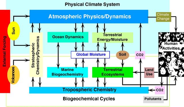
12 Bretherton Diagram
13


14

15 NRC Report on Grand Challenges Tom Graedel, Chair Actually brought to NRC by the National Science Board of NSF Initiated many NSF Programs that included LCLUC

16 NSF Environmental Research and Education (ERE) Includes LCLUC Biocomplexity in the Environment Coupled Human-Natural Systems New: SEES
17 Land Use and Land Cover Change Primary Questions What processes determine the temporal and spatial distribution of land cover and land use change at local, regional, and global scales and how can land use and land cover be projected over time scales of years? How will the dynamics of land use, management, and cover change affect global environmental changes and regional-scale environmental and socioeconomic conditions, including economic welfare and human health? Goals Learn from the past retrospective assessment Understand the present monitoring, measuring, mapping Model the future forecasting changes in land use / cover Land use relation to other global changes - integrative modeling
18 Scientific Importance Land cover/land use change is the other global change Global and regional distribution and rates of change are poorly quantified and the causes are poorly understood The science of land use dynamics is starting to emerge Findings from improved monitoring of land cover dynamics are challenging conventional wisdom Dynamic spatially explicit models needed incorporating change drivers and processes, land use interactions, role of institutions, biophysical feedbacks and climate change to permit realistic projections Land Use Dynamics identified by NRC as one of the Grand Challenges in Environmental Science
19 Practical Importance Land use is key to questions of societal vulnerability and resilience and integral to local and regional policy, resource management and development issues Better scientific understanding of land cover/land use change is needed for carbon trading, air quality and for assessing potential impacts of climate variability food security, flooding Realistic projections of land use change are needed for water resource and ecosystem management and regional planning,
20 LCLUC and early implementation criteria for USGCRP LCLUC is truly emerging interdisciplinary research LCLUC s regional emphasis will necessitate development of approaches for regional research and interactions LCLUC as a strong human dimension understanding the cause and effect of land use change requires social science LULCC element has direct societal relevance Critical dependencies from other USGCRP elements on understanding changes in land use and land cover (baselines, historic record and projections) e.g. from carbon and water cycle, atmospheric composition, ecosystem functioning and services and human welfare Research currently being supported by different agencies would benefit from interagency coordination
21 Tractability NRC Grand Challenge addresses scientific readiness Newly available databases permit new research e.g.nasa s global orthorectified Landsat coverage for 1990 s and 2000 and Moderate Resolution global land cover, % tree cover, fire distributions Recent advances in imagery analysis and geographic information science Advances in the analysis of spatial data Increased inter and multidisciplinary interest in the science of land use/cover change LULCC has an established and well documented international science plan currently in the implementation stage Some LULCC research already underway within federal agencies combining physical and social science e.g. USDA, USGS, EPA, NASA shows feasibility and needs strengthening to gain critical mass

22


23
24

25
26

27


28
Science Rationale. Status of Deforestation Measurement. Main points for carbon. Measurement needs. Some Comments Dave Skole
 Science Rationale Status of Deforestation Measurement Some Comments Dave Skole Tropical deforestation is related to: Carbon cycle and biotic emissions/sequestration Ecosystems and biodiversity Water and
Australia s National Carbon Accounting System. Dr Gary Richards Director and Principal Scientist
 Australia s National Carbon Accounting System Dr Gary Richards Director and Principal Scientist Government Commitment The Australian Government has committed to a 10 year, 3 phase, ~$35M program for a
Review for Introduction to Remote Sensing: Science Concepts and Technology
 Review for Introduction to Remote Sensing: Science Concepts and Technology Ann Johnson Associate Director ann@baremt.com Funded by National Science Foundation Advanced Technological Education program [DUE
Belmont Forum Collaborative Research Action on Mountains as Sentinels of Change
 Belmont Forum Collaborative Research Action on Mountains as Sentinels of Change 1. Background and rationale Mountains exist in many regions of the world and are home to a significant fraction of the world
CIESIN Columbia University
 Conference on Climate Change and Official Statistics Oslo, Norway, 14-16 April 2008 The Role of Spatial Data Infrastructure in Integrating Climate Change Information with a Focus on Monitoring Observed
National and Sub-national Carbon monitoring tools developed at the WHRC
 National and Sub-national Carbon monitoring tools developed at the WHRC Nadine Laporte Woods Hole Research Center A. Baccini, W. Walker, S. Goetz, M. Sun, J. Kellndorfer Kigali, 20 th June 2011 Why measuring
Data Management for the North American Carbon Program
 Image courtesy of NASA/GSFC Data Management for the North American Carbon Program Bob Cook, Eric Sundquist, Tom Boden,, and Peter Thornton RS in NACP Workshop Missoula, MT August 20, 2004 NACP Data and
Q&A with Ilan Chabay Interviewed by Joelle Seligson
 Q&A with Ilan Chabay Interviewed by Joelle Seligson It was a case of professional schizophrenia but a very useful one, laughs Ilan Chabay about his varied career path. He has dabbled in the natural sciences,
Land Product Validation
 CEOS WGCV Land Product Validation Sub-Group Joanne Nightingale 1, Jaime Nickeson 1 & Gabriela Schaepman-Strub 2 ( 1 Sigma Space Corp / NASA GSFC, 2 University of Zurich) ~ With input from LPV Focus Group
A remote sensing instrument collects information about an object or phenomenon within the
 Satellite Remote Sensing GE 4150- Natural Hazards Some slides taken from Ann Maclean: Introduction to Digital Image Processing Remote Sensing the art, science, and technology of obtaining reliable information
Data Management Framework for the North American Carbon Program
 Data Management Framework for the North American Carbon Program Bob Cook, Peter Thornton, and the Steering Committee Image courtesy of NASA/GSFC NACP Data Management Planning Workshop New Orleans, LA January
Global Climate Change: Carbon Reporting Initiative
 United States Agency for International Development Cooperative Agreement No. EEM-A-00-06-00024-00 Global Climate Change: Carbon Reporting Initiative January 2012 Submitted by: Nancy Harris Ecosystem Services
Landsat Monitoring our Earth s Condition for over 40 years
 Landsat Monitoring our Earth s Condition for over 40 years Thomas Cecere Land Remote Sensing Program USGS ISPRS:Earth Observing Data and Tools for Health Studies Arlington, VA August 28, 2013 U.S. Department
NASA Earth System Science: Structure and data centers
 SUPPLEMENT MATERIALS NASA Earth System Science: Structure and data centers NASA http://nasa.gov/ NASA Mission Directorates Aeronautics Research Exploration Systems Science http://nasascience.nasa.gov/
TOPIC 4 Disaster Risks, Mitigation, Warning Systems & Socio-Economic Impacts. Jim Davidson
 TOPIC 4 Disaster Risks, Mitigation, Warning Systems & Socio-Economic Impacts Jim Davidson Richard Murnane Bill Read Lixion Avila - ST Chan Linda Anderson-Berry David King - Ryan Crompton IWTC-VII November
Geospatial Software Solutions for the Environment and Natural Resources
 Geospatial Software Solutions for the Environment and Natural Resources Manage and Preserve the Environment and its Natural Resources Our environment and the natural resources it provides play a growing
CDI SSF Category 1: Management, Policy and Standards
 CDI SSF Category 1: Management, Policy and Standards Developing a Data Management Plan for Implementation: Best Practices for the Collection, Management, Storing, and Sharing of Geospatial and Non-geospatial
Strategic Vision. for Stewarding the Nation s Climate Data. Our. NOAA s National Climatic Data Center
 Strategic Vision Our for Stewarding the Nation s Climate Data NOAA s National Climatic Data Center M AY 2013 Our Strategic Vision for Stewarding the Nation s Climate Data 2 FOREWORD From the Director The
INVESTIGA I+D+i 2013/2014
 INVESTIGA I+D+i 2013/2014 SPECIFIC GUIDELINES ON AEROSPACE OBSERVATION OF EARTH Text by D. Eduardo de Miguel October, 2013 Introducction Earth observation is the use of remote sensing techniques to better
The Food-Energy-Water Nexus in Agronomy, Crop and Soil Sciences
 The Food-Energy-Water Nexus in Agronomy, Crop and Soil Sciences February 4, 2016 In the fall of 2015 the Agronomy, Crop Science and Soil Science societies put out a call for white papers to help inform
Climate Change Impacts on the Built Environment in the United States and Implications for Sustainability
 Climate Change Impacts on the Built Environment in the United States and Implications for Sustainability Dale A. Quattrochi NASA Earth Science Office/ZP11 Marshall Space Flight Center Huntsville, AL Outline
Integrated Global Carbon Observations. Beverly Law Prof. Global Change Forest Science Science Chair, AmeriFlux Network Oregon State University
 Integrated Global Carbon Observations Beverly Law Prof. Global Change Forest Science Science Chair, AmeriFlux Network Oregon State University Total Anthropogenic Emissions 2008 Total Anthropogenic CO 2
Welcome to NASA Applied Remote Sensing Training (ARSET) Webinar Series
 Webinar Series") Welcome to NASA Applied Remote Sensing Training (ARSET) Webinar Series Introduction to Remote Sensing Data for Water Resources Management Course Dates: October 17, 24, 31 November 7, 14 Time: 8-9 a.m.
Welcome to NASA Applied Remote Sensing Training (ARSET) Webinar Series Introduction to Remote Sensing Data for Water Resources Management Course Dates: October 17, 24, 31 November 7, 14 Time: 8-9 a.m.
Statement of Qualifications
 Statement of Qualifications Prepared By: JAYA Corporation 4900 University Square, Suite 30 Huntsville, AL 35816 TEL: (256) 722-0700 FAX: (256) 722-0711 EMAIL: igis@jaya corp.com Small Disadvantaged Business,
International Decade of Soils Workshop (IDOS)
") International Decade of Soils Workshop (IDOS) March 14-16 2016 UCAR Foothills Campus in Boulder, CO Sponsored by the Carbon Cycle Interagency Working Group Workshop Organizers Melanie Mayes (ORNL), Kate
International Decade of Soils Workshop (IDOS) March 14-16 2016 UCAR Foothills Campus in Boulder, CO Sponsored by the Carbon Cycle Interagency Working Group Workshop Organizers Melanie Mayes (ORNL), Kate
Advancing Disaster Risk Reduction to Enhance Sustainable Development in a Changing World 20 June -1 July 2016, UN Campus, Bonn
 CALL FOR APPLICATIONS Announcement UNITED NATIONS UNIVERSITY Institute for Environment and Human Security Intensive Summer Course 2016 Advancing Disaster Risk Reduction to Enhance Sustainable Development
THE STRATEGIC PLAN OF THE HYDROMETEOROLOGICAL PREDICTION CENTER
 THE STRATEGIC PLAN OF THE HYDROMETEOROLOGICAL PREDICTION CENTER FISCAL YEARS 2012 2016 INTRODUCTION Over the next ten years, the National Weather Service (NWS) of the National Oceanic and Atmospheric Administration
Innovation and new land monitoring services for climate change, forests and agroforestry
 Innovation and new land monitoring services for climate change, forests and agroforestry Martin Herold Wageningen University Center for Geoinformation Current distribution of aboveground biomass Terrestrial
Future needs of remote sensing science in Antarctica and the Southern Ocean: A report to support the Horizon Scan activity of COMNAP and SCAR
 Future needs of remote sensing science in Antarctica and the Southern Ocean: A report to support the Horizon Scan activity of COMNAP and SCAR Thomas Wagner (thomas.wagner@nasa.gov) Charles Webb NASA Cryospheric
GEOGRAPHICAL INFORMATION SYSTEM (GIS) AS A TOOL FOR CERTIFICATION OF BIOFUELS IN ARGENTINA
 AS A TOOL FOR CERTIFICATION OF BIOFUELS IN ARGENTINA") GEOGRAPHICAL INFORMATION SYSTEM (GIS) AS A TOOL FOR CERTIFICATION OF BIOFUELS IN ARGENTINA International Workshop CHALLENGES AND SOCIAL AND ENVIRONMENTAL IMPACTS OF THE BIOFUEL PRODUCTION IN AMERICA. Buenos
GEOGRAPHICAL INFORMATION SYSTEM (GIS) AS A TOOL FOR CERTIFICATION OF BIOFUELS IN ARGENTINA International Workshop CHALLENGES AND SOCIAL AND ENVIRONMENTAL IMPACTS OF THE BIOFUEL PRODUCTION IN AMERICA. Buenos
Present Status of Coastal Environmental Monitoring in Korean Waters. Using Remote Sensing Data
 Present Status of Coastal Environmental Monitoring in Korean Waters Using Remote Sensing Data Sang-Woo Kim, Young-Sang Suh National Fisheries Research & Development Institute #408-1, Shirang-ri, Gijang-up,
Resolution XII.13. Wetlands and disaster risk reduction
 12 th Meeting of the Conference of the Parties to the Convention on Wetlands (Ramsar, Iran, 1971) Punta del Este, Uruguay, 1-9 June 2015 Resolution XII.13 Wetlands and disaster risk reduction 1. RECALLING
Integrated Risk Management System Components in the GEO Architecture Implementation Pilot Phase 2 (AIP-2)
") Meraka Institute ICT for Earth Observation PO Box 395 Pretoria 0001, Gauteng, South Africa Telephone: +27 12 841 3028 Facsimile: +27 12 841 4720 University of KwaZulu- Natal School of Computer Science
Meraka Institute ICT for Earth Observation PO Box 395 Pretoria 0001, Gauteng, South Africa Telephone: +27 12 841 3028 Facsimile: +27 12 841 4720 University of KwaZulu- Natal School of Computer Science
5 day Training on Climate Change and Adaptation
 Training Programme 5 day Training on and Adaptation Developed by: Bangladesh Centre for Advanced Studies (BCAS) [A comprehensive training module along with guideline for trainers aiming to enhance capacity
5.0 ENVIRONMENTAL IMPACT ASSESSMENT METHODS
 5.0 ENVIRONMENTAL IMPACT ASSESSMENT METHODS The methods that are used to conduct the environmental impact assessment (EIA) of the Project are described in this section. The EIA uses a methodological framework
Advance unedited version. Decision -/CP.13. Bali Action Plan
 The Conference of the Parties, Decision -/CP.13 Bali Action Plan Resolving to urgently enhance implementation of the Convention in order to achieve its ultimate objective in full accordance with its principles
National Land Cover Database Visualization and Information Tool
 CDI SSF Category 3: Data and Information Assets National Land Cover Database Visualization and Information Tool Applicants/Principle Investigators(s): Collin Homer, USGS EROS, 47914 252 nd St, Sioux Falls,
Strategic Program Management
 Governance Assessment Organizational Change Management Strategic Program Management Continuous Improvement Framework Processes Strategy Strategic Program Management Bob Prieto Published by Construction
Asia-Pacific Network for Global Change Research
 Asia-Pacific Network for Global Change Research Twenty Years of Collaborative Research/Capacity Building on LC/LUC and GHG Emissions Erna Sri Adiningsih APN Scientific Planning Group member for Indonesia
INTENDED NATIONALLY DETERMINED CONTRIBUTIONS (INDCs)
") UNITED REPUBLIC OF TANZANIA INTENDED NATIONALLY DETERMINED CONTRIBUTIONS (INDCs) 1. Introduction The United Republic of Tanzania, which comprises of Tanzania Mainland and Zanzibar, brings forth her Intended
UNITED REPUBLIC OF TANZANIA INTENDED NATIONALLY DETERMINED CONTRIBUTIONS (INDCs) 1. Introduction The United Republic of Tanzania, which comprises of Tanzania Mainland and Zanzibar, brings forth her Intended
China s Global Land Cover Mapping at 30 M Resolution
 Geospatial World Forum 2015 China s Global Land Cover Mapping at 30 M Resolution Jun Chen1,2 1 National Geomatics Center, 2ISPRS Lisbon, Portugal, May 28,2015 GlobeLand30 Video Contents Introduction Introduction
Oklahoma Geographic Information Council
 Oklahoma State University Agriculture Cooperative Extension Service Presentation To: Oklahoma Geographic Information Council For McCurtain County GIS Pilot Project Project Overview & Project Results Proposed
I m Randy Swaty, ecologist on The Nature Conservancy s LANDFIRE team. In the next half hour, I ll introduce LANDFIRE to you, talk about how we
 Welcome to the LANDFIRE and the California Fire Science Consortium webinar Got Veggies. I m Jeannie Patton, Communications Lead for The Nature Conservancy s LANDFIRE Program. We re co-hosting this webinar
Draft Resolution on Science, technology and innovation for development
 Draft Resolution on Science, technology and innovation for development The Economic and Social Council, Recognizing the role of the Commission on Science and Technology for Development as the United Nations
How To Manage Protected Areas
 ECHOES FROM BARILOCHE: Conclusions, Recommendations and Action Guidelines The Second Latin American Congress on National Parks and other Protected Areas aimed to asses, value and project the contribution
Improving global data on forest area & change Global Forest Remote Sensing Survey
 Improving global data on forest area & change Global Forest Remote Sensing Survey work by FAO and partners - Adam Gerrand, E. Lindquist, R. D Annunzio, M. Wilkie, FAO, - F. Achard et al. TREES team at
Ecosystem Services and Government Decision Making
 October 7, 2015 M-16-01 E DEPARTMENTS AND AGENCIES FROM: SUBJECT: Incorporating Ecosystem Services into Federal Decision Making Overview. Nature provides vital contributions to economic and social well-being
Using Remote Sensing to Monitor Soil Carbon Sequestration
 Using Remote Sensing to Monitor Soil Carbon Sequestration E. Raymond Hunt, Jr. USDA-ARS Hydrology and Remote Sensing Beltsville Agricultural Research Center Beltsville, Maryland Introduction and Overview
NCEAS Workshop 2: A Standard Assessment Framework for Ecosystem Services
 NCEAS Workshop 2: A Standard Assessment Framework for Ecosystem Services Organized by the National Ecosystem Services Partnership, Duke University, NatureServe, and Defenders of Wildlife and hosted by
The National Integrated Drought Information System. The NIDIS Implementation Team www.drought.gov
 The National Integrated Drought Information System The NIDIS Implementation Team www.drought.gov National Integrated Drought Information System No systematic collection and analysis of social, environmental,
Outline - needs of land cover - global land cover projects - GLI land cover product. legend. Cooperation with Global Mapping project
 Land Cover Mapping by GLI data Ryutaro Tateishi Center for Environmental Remote Sensing (CEReS) Chiba University E-mail: tateishi@ceres.cr.chiba-u.ac.jp Outline - needs of land cover - global land cover
Integrated Water Resources Science and Services. National Water Center
 TOO MUCH POOR QUALITY TOO LITTLE Integrated Water Resources Science and Services and the National Water Center Partnering to Address America s Water Resources Information Needs Mary G. Mullusky National
BIRMINGHAM DEVELOPMENT PLAN EXAMINATION MATTER L: CLIMATE CHANGE AND FLOOD RISK STATEMENT ON BEHALF OF BIRMINGHAM CITY COUNCIL
 BIRMINGHAM DEVELOPMENT PLAN EXAMINATION MATTER L: CLIMATE CHANGE AND FLOOD RISK STATEMENT ON BEHALF OF BIRMINGHAM CITY COUNCIL Main Issue: Are the Plan s policies to mitigate and adapt to climate change
Utilizing satellite-based information for disaster risk assessment- why and how?
 Utilizing satellite-based information for disaster risk assessment- why and how? Peeranan Towashiraporn ADPC Session 1, UN International Conference on Space-based Technologies for Disaster Management September
BEST PRACTICE NOTE LANDSCAPE ASSESSMENT AND SUSTAINABLE MANAGEMENT 10.1 NZILA. Members Documentation
 BEST PRACTICE NOTE LANDSCAPE ASSESSMENT AND SUSTAINABLE MANAGEMENT 10.1 NZILA Members Documentation Background In August 2008, the New Zealand Institute of Landscape Architects (NZILA) Education Foundation
Government Accountability Office
 Government Accountability Office GAO s Climate Change Work THIS PRELIMINARY WORK OF GAO IS SUBJECT TO REVISION AND SHOULD NOT BE REPRODUCED OR DISTRIBUTED. SOME GRAPHICS MAY BE ENTITLED TO COPYRIGHT. Page
New challenges of water resources management: Title the future role of CHy
 New challenges of water resources management: Title the future role of CHy by Bruce Stewart* Karl Hofius in his article in this issue of the Bulletin entitled Evolving role of WMO in hydrology and water
Technology For Adaptation. Forestry Conservation Management. Dr. Javier Aliaga Lordemann
 Technology For Adaptation. Forestry Conservation Management Dr. Javier Aliaga Lordemann Forests has more carbon store than the currently carbon free atmosphere. By contrast, are important sources of emissions
Geospatial intelligence and data fusion techniques for sustainable development problems
 Geospatial intelligence and data fusion techniques for sustainable development problems Nataliia Kussul 1,2, Andrii Shelestov 1,2,4, Ruslan Basarab 1,4, Sergii Skakun 1, Olga Kussul 2 and Mykola Lavreniuk
Christopher Young Speaking notes for presentation to World Heritage UK Technical Workshop on WHS Management Plans and Systems, 25 th January, 2016
 WORLD HERITAGE UK TECHNICAL WORKSHOP, EDINBURGH, 25 TH JANUARY, 2016 DRAFT OUTLINE FOR CHRISTOPHER YOUNG S PRESENTATION CHANGES IN THE UNESCO OPERATIONAL GUIDELINES, AND OTHER CONVENTION RELATED ACTIVITY
National Drought Mitigation Center: Programs and Activities
 National Drought Mitigation Center: Programs and Activities Dr. Donald A. Wilhite, Director National Drought Mitigation Center School of Natural Resources University of Nebraska-Lincoln The Cycle of Disaster
U.S. Geological Survey Earth Resources Operation Systems (EROS) Data Center
 Data Center") U.S. Geological Survey Earth Resources Operation Systems (EROS) Data Center World Data Center for Remotely Sensed Land Data USGS EROS DATA CENTER Land Remote Sensing from Space: Acquisition to Applications
U.S. Geological Survey Earth Resources Operation Systems (EROS) Data Center World Data Center for Remotely Sensed Land Data USGS EROS DATA CENTER Land Remote Sensing from Space: Acquisition to Applications
ERP: Willamette-Ecosystem Services Project
 ERP: Willamette-Ecosystem Services Project Presented by Iris Goodman to NAS Sustainability R&D Forum October 17-18, 2007 Conserving ecosystem services through proactive decision-making making Linking Human
Results of the Conference
 International Conference on WATER SCARCITY, GLOBAL CHANGES, and GROUNDWATER MANAGEMENT RESPONSES December 2008, University of California, Irvine, United States Results of the Conference Convened by: UNESCO,
18 Month Summary of Progress
 18 Month Summary of Progress July 2014 1 Context Ecosystems provide humankind with a wide range of resources, goods and services. Yet the rate at which we consume and exploit these is increasing so rapidly
2011 2016 Strategic Plan for Research and Development Water, Air, and Soil Strategic Program Area
 2011 2016 Strategic Plan for Research and Development Water, Air, and Soil Strategic Program Area Executive Summary Research and Development (R&D) in the Forest Service, U.S. Department of Agriculture,
Archiving of Simulations within the NERC Data Management Framework: BADC Policy and Guidelines.
 Archiving of Simulations within the NERC Data Management Framework: BADC Policy and Guidelines. Introduction 1. Issues associated with archiving information about the environment made by measurement are
Joint Polar Satellite System (JPSS)
") Joint Polar Satellite System (JPSS) John Furgerson, User Liaison Joint Polar Satellite System National Environmental Satellite, Data, and Information Service National Oceanic and Atmospheric Administration
Joint Polar Satellite System (JPSS) John Furgerson, User Liaison Joint Polar Satellite System National Environmental Satellite, Data, and Information Service National Oceanic and Atmospheric Administration
RISK AND RESILIENCE $58,000,000 +$38,000,000 / 190.0%
 RISK AND RESILIENCE $58,000,000 +$38,000,000 / 190.0% Overview The economic competiveness and societal well-being of the United States depend on the affordability, availability, quality, and reliability
Creating a More Resilient Future. Friday 30 May, 11:00 to 12:30, Rooms S29-31
 Creating a More Resilient Future Friday 30 May, 11:00 to 12:30, Rooms S29-31 Empowering Resilience With GIS ICLEI Smart Resilient Cities Strategic Use of Spatial Systems Jim Geringer, Esri Former Governor,
Opportunities in Standing Programs Opportunities in Special Programs. Dr. Robert O Connor Dr. David McGinnis
 Opportunities in Standing Programs Opportunities in Special Programs Dr. Robert O Connor Dr. David McGinnis All of them Particularly Decision, Risk and Management Sciences Infrastructure Management and
Simulating the urban heat island of Greater Houston, Texas
 09 July 2013 Simulating the urban heat island of Greater Houston, Texas Andrew Monaghan, Michael Barlage, Leiqiu Hu, Nathan Brunsell, Johannes Feddema, Olga Wilhelmi Steve Sain 1 The System for Integrated
Management of Change and Organizational Development. Batch: FO_J11_01 Subject: Management CS Foundation Programme The ICSI Ahmedabad Chapter
 Management of Change and Organizational Development Batch: FO_J11_01 Subject: Management CS Foundation Programme The ICSI Ahmedabad Chapter Meaning of Change Change may be defined as a variation in the
THE NATIONAL SPACE WEATHER PROGRAM
 1 Office of the Federal Coordinator for Meteorological Services and Supporting Research (OFCM) THE NATIONAL SPACE WEATHER PROGRAM Committee on Solar and Space Physics National Research Council Space Studies
ForeCAST : Use of VHR satellite data for forest cartography
 ForeCAST : Use of VHR satellite data for forest cartography I-MAGE CONSULT UCL- Dpt Sciences du Milieu et de l Aménagement du Territoire Description of the partnership I-MAGE Consult Private partner Team
AMS Atmospheric Science Degree Statement
 AMS Atmospheric Science Degree Statement Mohan Ramamurthy AMS Board on Higher Education Unidata/UCAR 14 October 2004 AMS and AGU Heads and Chairs Meeting Boulder, CO Ad-hoc Working Group Dr. Mohan Ramamurthy,
The USGS Landsat Big Data Challenge
 The USGS Landsat Big Data Challenge Brian Sauer Engineering and Development USGS EROS bsauer@usgs.gov U.S. Department of the Interior U.S. Geological Survey USGS EROS and Landsat 2 Data Utility and Exploitation
Project Theory-Climate Change and Traditional Ecological Knowledge Adaption in the Klamath Basin
 Project Theory-Climate Change and Traditional Ecological Knowledge Adaption in the Klamath Basin Frank K. Lake Lead Science and TEK Mentor for project Education 1995 B.S. University of California, Davis.
Using Remote Sensing Imagery to Evaluate Post-Wildfire Damage in Southern California
 Graham Emde GEOG 3230 Advanced Remote Sensing February 22, 2013 Lab #1 Using Remote Sensing Imagery to Evaluate Post-Wildfire Damage in Southern California Introduction Wildfires are a common disturbance
Turku School of Economics: Strategy for 2010 2015
 Turku School of Economics: Strategy for 2010 2015 Appendix A TURKU SCHOOL OF ECONOMICS STRATEGY FOR 2010 2015 1 The strategic position of the Turku School of Economics... 1 1.1 Operating environment...
Argonne National Laboratory
 Argonne National Laboratory Using Climate Data to Inform Critical Infrastructure Resilience and Urban Sustainability Decisionmaking National Academy of Sciences Roundtable on Science and Technology for
GCOS/GOOS/GTOS JOINT DATA AND INFORMATION MANAGEMENT PLAN
 GCOS/GOOS/GTOS JOINT DATA AND INFORMATION MANAGEMENT PLAN Prepared by the Joint Data and Information Management Panel (JDIMP) VERSION 1.0 May 2000 GCOS - 60 GOOS - 70 (WMO/TD No. 1004) TABLE OF CONTENTS
Course Outline MS Global Environmental Change candidates are required to complete the core module, as well as three compulsory modules:
 ISA Master s Degrees in Sustainability Degree Title Master of Science in Global Environmental Change University King s College University Overview King's College London, ranked among the top 25 universities
Global environmental information Examples of EIS Data sets and applications
 METIER Graduate Training Course n 2 Montpellier - february 2007 Information Management in Environmental Sciences Global environmental information Examples of EIS Data sets and applications Global datasets
RECOGNIZING THE VALUE OF WATER QUALITY MONITORING
 CHAPTER 15: CREATING A NATIONAL WATER QUALITY MONITORING NETWORK Ongoing monitoring is essential to assess the health of ocean and coastal ecosystems and detect changes over time. More than any other measure,
The NASA NEESPI Data Portal to Support Studies of Climate and Environmental Changes in Non-boreal Europe
 The NASA NEESPI Data Portal to Support Studies of Climate and Environmental Changes in Non-boreal Europe Suhung Shen NASA Goddard Space Flight Center/George Mason University Gregory Leptoukh, Tatiana Loboda,
The role of managed fire in ecosystem services of UK moorlands and heathlands. Welcome
 The role of managed fire in ecosystem services of UK moorlands and heathlands FIRES seminar series, No. 1 Welcome Julia McMorrow FIRES seminar series coordinator www.fires-seminars.org.uk FIRES Fire Interdisciplinary
Corporate Health and Safety Strategy
 Corporate Health and Safety Strategy 2010-2013 Policy Author: Health and Safety Committee Policy Owner (for updates) Head of Estates and Facilities Engagement and Consultation Groups: Approval Record Date
Remote Sensing for Geographical Analysis
 Remote Sensing for Geographical Analysis Geography 651, Fall 2008 Department of Geography Texas A&M University (3 credit hours) Instructor: Dr. Hongxing Liu Office hours: Tue & Thur 10:00AM-12:00AM, O&M
BIRDLIFE INTERNATIONAL S ASKS FOR UNFCCC COP21
 Background BIRDLIFE INTERNATIONAL S ASKS FOR UNFCCC COP21 The climate change talks in Paris (UNFCCC COP21) are the culmination of several years of negotiations towards the adoption of a global climate
How To Understand And Act On Climate Change
 Federal Climate Change Expenditures Report to Congress August 2013 TABLE OF CONTENTS Page 1. Introduction... 1 1.1 BACKGROUND... 2 1.2 REPORT OUTLINE... 3 2. Climate Change Science... 6 2.1 SELECTED AGENCY
Real-time Global Flood Monitoring and Forecasting using an Enhanced Land Surface Model with Satellite and NWP model based Precipitation
 Real-time Global Flood Monitoring and Forecasting using an Enhanced Land Surface Model with Satellite and NWP model based Precipitation Huan Wu,2, Robert F. Adler, 2, Yudong Tian, 2, George J. Huffman
Protected Areas Resilient to Climate Change, PARCC West Africa
 Communication Strategy (PARCC Activity 4.2) Ver. 1. Protected Areas Resilient to Climate Change, PARCC West Africa 2011 Rapid Screening of Vulnerability Assessment Tools and Framework Proposal Executive
SMEX04 Land Use Classification Data
 Notice to Data Users: The documentation for this data set was provided solely by the Principal Investigator(s) and was not further developed, thoroughly reviewed, or edited by NSIDC. Thus, support for
Urban Ecosystem Analysis Atlanta Metro Area Calculating the Value of Nature
 August 2001 Urban Ecosystem Analysis Atlanta Metro Area Calculating the Value of Nature Report Contents 2 Project Overview and Major Findings 3 Regional Analysis 4 Local Analysis 6 Using Regional Data
Greening REDD+ Challenges and opportunities for forest biodiversity conservation. Workshop summary
 Greening REDD+ Challenges and opportunities for forest biodiversity conservation Workshop summary D. Benick 1 *, S. Entenmann 2 *, T. Pistorius 1, C.B. Schmitt 2 1 Institute of Forest and Environmental
Estimating Firn Emissivity, from 1994 to1998, at the Ski Hi Automatic Weather Station on the West Antarctic Ice Sheet Using Passive Microwave Data
 Estimating Firn Emissivity, from 1994 to1998, at the Ski Hi Automatic Weather Station on the West Antarctic Ice Sheet Using Passive Microwave Data Mentor: Dr. Malcolm LeCompte Elizabeth City State University
GIS: Geographic Information Systems A short introduction
 GIS: Geographic Information Systems A short introduction Outline The Center for Digital Scholarship What is GIS? Data types GIS software and analysis Campus GIS resources Center for Digital Scholarship
ASEAN INTEGRATED FOOD SECURITY (AIFS) FRAMEWORK AND STRATEGIC PLAN OF ACTION ON FOOD SECURITY IN THE ASEAN REGION (SPA-FS) 2009-2013
 FRAMEWORK AND STRATEGIC PLAN OF ACTION ON FOOD SECURITY IN THE ASEAN REGION (SPA-FS) 2009-2013") ASEAN INTEGRATED FOOD SECURITY (AIFS) FRAMEWORK AND STRATEGIC PLAN OF ACTION ON FOOD SECURITY IN THE ASEAN REGION (SPA-FS) 2009-2013 BACKGROUND The sharp increase in international food prices in 2007/2008
ASEAN INTEGRATED FOOD SECURITY (AIFS) FRAMEWORK AND STRATEGIC PLAN OF ACTION ON FOOD SECURITY IN THE ASEAN REGION (SPA-FS) 2009-2013 BACKGROUND The sharp increase in international food prices in 2007/2008
Aalto Entrepreneurial Ecosystem. 10.9.2013 LES Conference, Copenhagen Tapio Siik, Head of Aalto Center for Entrepreneurship
 Aalto Entrepreneurial Ecosystem 10.9.2013 LES Conference, Copenhagen Tapio Siik, Head of Aalto Center for Entrepreneurship ZenRobotics Trailer ZenRobotics Ltd., founded in 2007, is a Finnish high-tech