SOUTHWEST FLORIDA PLANS FOR CHANGE
|
|
|
- Everett Roland Fisher
- 7 years ago
- Views:
Transcription
1 SOUTHWEST FLORIDA PLANS FOR CHANGE James W. Beever III, Whitney Gray, Moji Abimbola, Dan Cobb, John Gibbons, Dave Hutchinson, Dan Trescott, Jason Utley from SWFRPC, and Lisa Beever and Judy Ott from CHNEP


2 STUDY AREA Polk Manatee Hardee Desoto Sarasota Glades Charlotte Hendry Lee Collier

3 Regional Vulnerability Assessment ( ) Punta Gorda Adaptation Plan (CRE ) Vulnerability Assessment Lite ( ) Climate Change Environmental Indicators (CRE ) Model Ordinances/Comprehensive Plan (CRE ) Punta Gorda Comprehensive Plan Amendments ( ) Climate Change Vulnerability Assessment and Adaptation Opportunities for Salt Marsh Types in Southwest Florida ( ) Seagrass response to SLR (2009) Lee County Vulnerability Assessment & Resiliency Strategy ( ) Conceptual Ecological Models (CRE )
 Seagrass response to SLR (2009) Lee County Vulnerability Assessment & Resiliency Strategy (2009-2010) Conceptual Ecological")
4 COMPREHENSIVE SOUTHWEST FLORIDA/ CHARLOTTE HARBOR CLIMATE CHANGE VULNERABILITY ASSESSMENT


5 DATABASE OF POTENTIAL CLIMATE CHANGE EFFECTS 84 effects potential in southwest Florida 5 future scenarios of climate change into the year 2200 Analysis of effects with no action and with various adaptations Source material citation and PDF library Current conditions and potential future conditions 400+ source documents reviewed


6 The climate of southwest Florida is changing now, and has been changing for millennia.


7
8 Tide Gauge Data for Key West ~ 30 cm / 100 yrs From Maul & Martin 1993

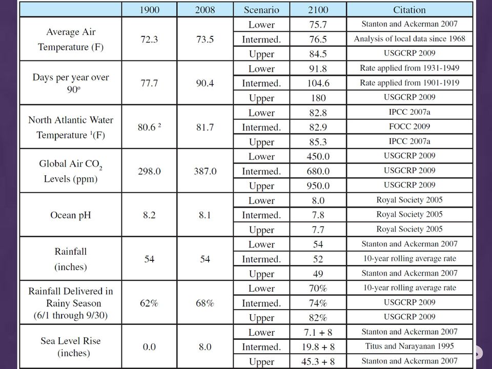
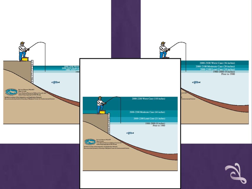
9 Probability of Sea Level Rise Probability (%) cm inches cm inches cm inches cm inches cm inches cm inches Rapid Stabilization Case (least) (moderate) (worst) Business as Usual *The results of this table are based on using Tables 9-1 and 9-2 of the USEPA Report "The Probability of Sea Level Rise". Basically, the formula is multiplying the historic sea level rise (2.3 mm/yr) in Southwest Florida (closest point used is St. Petersburg, Fl., Table 9-2) by the future number of years from 1990 plus the Normalized Sea Level Projections in Table 9-1 and Table ES-2. Two Future Climate Scenarios for Stanton and Ackerman 2007
 22 8.7 41 16.1 63 24.6 91 35.9 171 67.2 279 110.0 2.5 25 9.9 45 17.6 70 27.4 103 40.7 204 80.")

10 Potential Impacts of Climate Change Infrastructure Water Transportation Energy Supply & Use Health Weather-related Mortality Infectious Diseases Air Quality -Respiratory Illnesses Changes in the Climate Temperature Climate Instability Sea Level Rise Cultural Resources Economic Disruption Agriculture Crop yields Irrigation demands Forest Change in forest composition Shift geographic range of forests Forest Health and Productivity Water Resources Changes in water supply Water quality Increased competition for water Coastal Areas Erosion of beaches Inundate coastal lands Costs to defend coastal communities Wildlife and Ecosystems Shift in ecological zones Loss of habitat and species Damage to Habitats


11 Human Health

12
13 Estimated Values for Structures within Punta Gorda Based on the 100 Year Floodplain No. of Building Contents Functional Total Buildings Value Value Use Value Value Inside 100 Year Floodplain Outside 100 Year Floodplain 9,328 $1,502,477,972 $934,065,737 $112,042,972 $2,548,586, $90,433,868 $48,949,138 $3,529,030 $142,912,036 Total 9,986 $1,592,911,840 $983,014,875 $115,572,002 $2,691,498,717 Estimated Values for Historic Structures within Punta Gorda Based on the 100 Year Floodplain No. of Buildings Building Value Contents Value Functional Use Value Total Value Inside 100 Year Floodplain Outside 100 Year Floodplain 44 $21,914,968 $21,914,968 $426,480 $44,256,416 0 $0 $0 $0 $0 Total 44 $21,914,968 $21,914,968 $426,480 $44,256,416


14

15
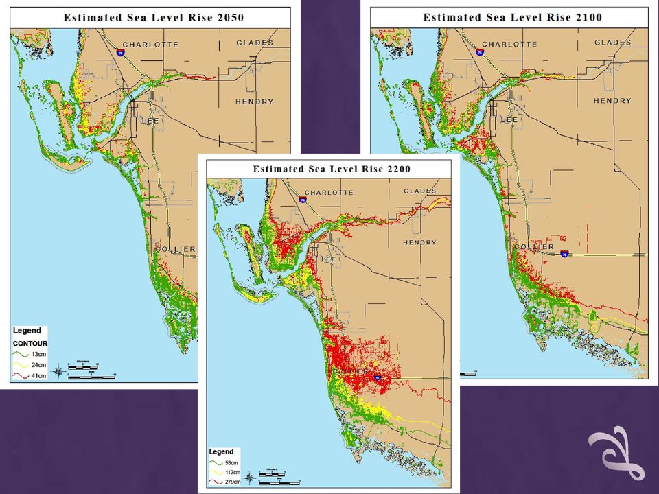
16 Table 3: Use Acreage Subject to 10 Feet Sea Level Rise Use Collier Lee Total Sq. Miles % of Region Agriculture 7, ,247 1,188 10, Commercial 2,363 9,247 6,260 1,082 18, Estate 1,005 16, ,894 20, Industrial 653 2,597 1, , Multi-Family 2,269 1,937 7,758 3,891 15, Preserve 615, , ,897 22, ,098 1, Single Family 53,444 89,621 50,668 45, , Total Acreage 682, , ,259 78,165 1,304,368 2,


17 City of Punta Gorda, Florida Population: 16,600 Area: 14 square miles Elevation: 0-15 ft. Already included climate change planning language in comprehensive plan

18 A CITIZEN-DRIVEN PROCESS 1 ST PUBLIC MEETING Participants filled out a survey providing demographics and previous experience with Hurricane Charley. Then, they wrote down the vulnerabilities they thought most important and played a trading card game, collaborating to group them into envelopes.

19 Public participation was key to the project. Participants then voted to prioritize the grouped vulnerabilities.

20 Punta Gorda s Grouped Vulnerabilities/ Areas For Adaptation Fish and Wildlife Habitat Degradation Inadequate Water Supply Flooding Unchecked or Unmanaged Growth Water Quality Degradation Education and Economy and Lack of Funds Fire Availability of Insurance

21 SECOND PUBLIC MEETING IDENTIFICATION OF ADAPTATIONS Participants labeled areas on maps where vulnerabilities and/or areas for adaptations existed. The labels named specific adaptations from citizen suggestions and from the literature. Adaptations that were NOT desired were also included.

22 Prioritized List of Adaptations Vulnerability Fish and Wildlife Habitat Degradation Inadequate Water Supply Flooding Unchecked or Unmanaged Growth Water Quality Degradation Education and Economy and Lack of Funds Fire Availability of Insurance First Adaptation Seagrass protection and restoration Xeriscaping and native plant landscaping Explicitly indicating in the comp plan which areas will retain natural shorelines Constraining locations for certain high risk infrastructure Restrict fertilizer use Promote green building alternatives through education, taxing incentives, green lending Drought preparedness planning (Implementation of other adaptations will reduce this vulnerability)
23 Implementation in Punta Gorda - From Concept to Concrete Acceptance by City Council New riverfront built with resilient design Public Works facility lost in Hurricane Charley relocated New Style High ground floor elevation Living shoreline with slope Substantial vegetative buffer with emergent wetlands and littoral shelf Modern stormwater treatment Significant fish and wildlife habitat Model Ordinance Development with UF Comprehensive Plan language added
24 LEE COUNTY CLIMATE CHANGE VULNERABILITY ASSESSMENT And Resiliency Strategy
25 VULNERABILITY ASSESSMENT Characterizes current Lee County climate Assesses significant potential climate changes and their effects in Lee County Suggests methods for prioritizing vulnerabilities
26 Patterns of Local Average Sea Level From the Ft. Myers Tide Gauge 23.3 ft 22.6 ft
27 Probability (%) cm inches cm inches cm inches cm inches cm inches cm inches Rapid Stabilization Case % chance % chance % chance Business as Usual *The results of this table are based on using Tables 9-1 and 9-2 of the USEPA Report "The Probability of Sea Level Rise". Basically, the formula is multiplying the historic sea level rise (2.3 mm/yr) in Southwest Florida (closest point used is St. Petersburg, Fl., Table 9-2) by the future number of years from 1990 plus the Normalized Sea Level Projections in Table 9-1 and Table ES-2. Two Future Climate Scenarios for Stanton and Ackerman 2007
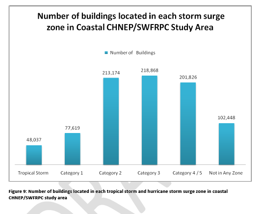
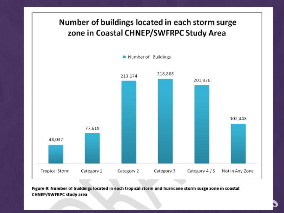
28 Development In Storm Surge Zones
29 CRITICAL FACILITIES Ports 1 Community Colleges 1 Hospitals 1 Boat Locks 2 Clinics 2 High Schools 2 Landfills 2 Airports 3 Police/Sheriff Facilities 3 Emergency Medical Services 3 Middle Schools 3 Communication Towers 9 Elementary Schools 11 Hurricane Shelters 12 Drinking Water Facilities 13 Electrical Facilities 14 Fire Stations 19 Nursing Facilities 26 Government Facilities 27 Sewage Treatment Facilities 43 Critical facilities in Lee County that are vulnerable to tropical storm and hurricane flooding and sea level rise Total: 197
30 VULNERABLE ROADS 191 miles of roads vulnerable to an 18 inch increase in sea level


31 Temperature increases could cause changes in ranges for habitats, crop plants, trees, endangered species, exotic species, pests, and disease vectors.
32 RESILIENCY STRATEGY Essential elements Summarizes vulnerabilities Summarizes input Identifies strategies to increase resiliency Identifies ways to incorporate resiliency into the LeePlan Outlines monitoring and evaluation strategies
33 ONLINE SURVEY Years in Florida Years in Lee County Perceptions of changes in weather, water quality, fishing and wildlife Impacts of Hurricane Charley on department assets, personnel and processes County Commissioners Division Heads Constitutional Officers Age & location of facilities Potential for facilities to be storm-hardened Potential energy-saving measures for facilities and staff What is the most important thing for Lee County to do to prepare for climate change? What is the worst thing Lee County could do to prepare for climate change?

34 INTERVIEWS Reaction to online survey Reaction to draft Did we leave out anything important? Who else should we talk to? Potential effects of climate change on the department Lee County s greatest vulnerability to climate change County Commissioners Division Heads Constitutional Officers How important do you think it is for Lee County to try to deal with climate change in an organized manner? Avoidance, minimization, mitigation and adaptation ideas
35 VULNERABILITIES IDENTIFIED BY INTERVIEWEES Buildings and County Infrastructure Impacts to roads from increased creek and stream flows More frequent replacement of materials Coastal Economies Declining property values impacting the County s ability to maintain infrastructure and provide adequate services Impact on tourism. Hotter temperatures will increase the cost of workers compensation. Land Use Planning and Growth Management Possible reduction of migration into the area and a possible increase in migration out of the area. Residents may experience increased response times for emergency services Economic Development Higher utility bills More frequent adverse working conditions for outdoor workers Coastal Protections Impacts to beaches and the demand for beach renourishment More frequent storm events with associated erosion Health and Human Services Increased impact on the economically disadvantaged Possible modification of work hours due to hotter temperatures. Water and Wastewater Could experience strains on our freshwater aquifers Surface water management issues Natural Systems and Resources Concerns regarding Lake Okeechobee flows Could experience impacts to landscaping and plants Could impact sea life and the estuary Destruction of ecological systems which could severely impact our tourism industry Education and Outreach Could impact nearly every area of how the County functions impacting the budget and demanding more interdepartmental and intergovernmental coordination Potential for increased variability of weather more rainfall during and longer periods of drought
36 Building to LEED certification standards. Offsite data storage and protection. RESILIENCY STRATEGIES Limit the placement of county facilities and infrastructure in flood prone and storm surge areas. This can be problematic since the facilities and infrastructure should be Technology infrastructure reduces the need for driving the fleet community-based. of automobiles to property locations for valuations. Building and development codes should be reviewed in light of vulnerabilities/to address strategies Native plants and reduced irrigation for County facilities Widening of Alico Road to accommodate business interested in energy research. Conservation 20/20 Locating healthcare facilities out of vulnerability zones. Modify County dress codes Update Comprehensive Plan to reflect changing conditions. Development of a Solar Strategy for inclusion in the comprehensive plan. Need more policy analysis regarding land use regulations. Reduce automobile dependence. Encourage behavior change in employee trips (carpooling, transit, bicycling, walking, teleworking, four day work weeks, reduction of VMTs, etc)
37 LEE COUNTY FINDINGS Monitor climate change Consider climate change effects in planning Continue to set aside natural areas as a buffer A more detailed communication plan could be developed to take it to the next level Reactive Responses Proactive Responses Ad hoc Responses
38 Implementation in Lee County Resiliency strategies incorporated into EAR and Comprehensive Plan revisions Development of LEED certified county facilities Development of biofuels Major energy efficiency effort in county facilities Establishment of an Office of Sustainability Lee County Public Safety Building with solar array
39 Regional Vulnerability Assessment ( ) Punta Gorda Adaptation Plan (CRE ) Vulnerability Assessment Lite ( ) Climate Change Environmental Indicators (CRE ) Model Ordinances/Comprehensive Plan (CRE ) Punta Gorda Comprehensive Plan Amendments ( ) Climate Change Vulnerability Assessment and Adaptation Opportunities for Salt Marsh Types in Southwest Florida ( ) Seagrass response to SLR (2009) Lee County Vulnerability Assessment & Resiliency Strategy ( ) Conceptual Ecological Models (CRE )


40 Contact Information Whitney Gray Senior Environmental Planner Southwest Florida Regional Planning Council 1926 Victoria Avenue Fort Myers, Florida Telephone ext 241 Fax Suncom website
Oregon. Climate Change Adaptation Framework
 Oregon Climate Change Adaptation Framework Oregon Environmental Quality Commission Climate Change Adaptation Framework Presentation at a glance: Purposes of the framework Participating agencies Climate
Comprehensive Economic Development Strategy (CEDS) Report 2012-2017. Southwest Florida Economic Development District
 Report 2012-2017. Southwest Florida Economic Development District") Southwest Florida Economic Development District Southwest Florida Economic Development District TABLE OF CONTENTS Strategy Report Executive Summary... v A. Background... 2 Community and Private Sector
Southwest Florida Economic Development District Southwest Florida Economic Development District TABLE OF CONTENTS Strategy Report Executive Summary... v A. Background... 2 Community and Private Sector
SECTION 3.2 CLIMATE AND PRECIPITATION
 SECTION 3.2 CLIMATE AND PRECIPITATION Ulster County Climate Data A preliminary analysis of the Preserve s weather data shows that the average temperature has risen about two degrees over the past 114 years.
Why should communities invest in resiliency? What are the steps communities can take to become more resilient?
 Community Preparedness for Flood Resiliency Nina Peek, AICP New York Planning Federation Board of Directors Senior Technical Director AKRF, Inc. Focus of Today s Presentation Why should communities invest
1.7.0 Floodplain Modification Criteria
 1.7.0 Floodplain Modification Criteria 1.7.1 Introduction These guidelines set out standards for evaluating and processing proposed modifications of the 100- year floodplain with the following objectives:
Miami-Dade County Roadmap for Adapting to Coastal Risk
 Miami-Dade County Roadmap for Adapting to Coastal Risk Vulnerability Assessment & Planning Workshop Results & Recommendations Roadmap for Adapting to Coastal Risk Page 1 Introduction GreenPrint is Miami-Dade
A Self Assessment to Address Climate Change Readiness in Your Community Midwest Region
 A Self Assessment to Address Climate Change Readiness in Your Community Midwest Region 0 Climate Change Readiness Index A Self Assessment to Address Climate Change Readiness in Your Community Communities
Goal 1 To protect the public health, safety and property from the harmful effects of natural disasters.
 Plan Framework for Coastal Management The purpose of this element is to provide for the protection of residents and property in within the coastal area of the host community, and to limit expenditures,
Develop hazard mitigation policies and programs designed to reduce the impact of natural and human-caused hazards on people and property.
 6.0 Mitigation Strategy Introduction A mitigation strategy provides participating counties and municipalities in the H-GAC planning area with the basis for action. Based on the findings of the Risk Assessment
SECTOR ASSESSMENT (SUMMARY): CLIMATE CHANGE. 1. Sector Performance, Problems, and Opportunities
: CLIMATE CHANGE. 1. Sector Performance, Problems, and Opportunities") Climate Resilience Sector Project (RRP TON 46351) Sector Road Map SECTOR ASSESSMENT (SUMMARY): CLIMATE CHANGE 1. Sector Performance, Problems, and Opportunities 1. Tonga is being affected by climate change,
Climate Resilience Sector Project (RRP TON 46351) Sector Road Map SECTOR ASSESSMENT (SUMMARY): CLIMATE CHANGE 1. Sector Performance, Problems, and Opportunities 1. Tonga is being affected by climate change,
REQUEST FOR PROPOSAL (RFP) For Consultancy Services
 For Consultancy Services") National Environment & Planning Agency 10 & 11 Caledonia Avenue, Kingston 5, Jamaica W.I. Tel: (876) 754-7540 Fax: (876) 754-7595-6, toll free help-line: 1-888-991-5005 Website: http://www.nepa.gov.jm
National Environment & Planning Agency 10 & 11 Caledonia Avenue, Kingston 5, Jamaica W.I. Tel: (876) 754-7540 Fax: (876) 754-7595-6, toll free help-line: 1-888-991-5005 Website: http://www.nepa.gov.jm
Ecosystem Services in the Greater Houston Region. A case study analysis and recommendations for policy initiatives
 Ecosystem Services in the Greater Houston Region A case study analysis and recommendations for policy initiatives Ecosystem Services Ecosystems provide services through their natural processes that we
Climate Change: A Local Focus on a Global Issue Newfoundland and Labrador Curriculum Links 2010-2011
 Climate Change: A Local Focus on a Global Issue Newfoundland and Labrador Curriculum Links 2010-2011 HEALTH Kindergarten: Grade 1: Grade 2: Know that litter can spoil the environment. Grade 3: Grade 4:
Community Workshop 5. Overarching Goals for Machado Lake Ecosystem and Wilmington Drain Multi-Use Projects
 City of Los Angeles Department of Public Works Bureau of Engineering Machado Lake Ecosystem Rehabilitation Project & Wilmington Drain Multi-Use Project Community Workshop 5 February 24, 2009 In association
PRESENTATION 2 MAJOR ENVIRONMENTAL PROBLEMS
 UNEP GLOBAL JUDGES PROGRAMME APPLICATION OF ENVIRONMENTAL LAW BY NATIONAL COURTS AND TRIBUNALS PRESENTATION 2 MAJOR ENVIRONMENTAL PROBLEMS OUTLINE OF PRESENTATION A) Major environmental issues B) Responses
COMMUNITY CERTIFICATIONS
 National Flood Insurance Program Community Rating System COMMUNITY CERTIFICATIONS Public reporting burden for this form is estimated to average 4 hours for annual recertification, per response. The burden
The St. Lucie River is 35 miles long and has two major forks, the North Fork and the South Fork. In the 1880s, the system was basically a freshwater
 The St. Lucie River is 35 miles long and has two major forks, the North Fork and the South Fork. In the 1880s, the system was basically a freshwater stream flowing into the Indian River Lagoon. An inlet
Using the Carbon Market to Provide Financial Support for Coastal Restoration and Protection. fact SHEET
 Using the Carbon Market to Provide Financial Support for Coastal Restoration and Protection fact SHEET Using the Carbon Market to Provide Financial Support for Coastal Restoration and Protection Coastal
Policy GRN-1.1.2. The City will adopt a Go Green Initiative to implement strategies to reduce greenhouse gas emissions within the City s borders.
 Vision Statement: Provide goals, objectives, and policies that preserve, improve, and promote responsible use and protect the City s natural and built environment. Goals, Objectives and Policies: Goal
Climate Change and Infrastructure Planning Ahead
 Climate Change and Infrastructure Planning Ahead Climate Change and Infrastructure Planning Ahead Infrastructure the physical facilities that support our society, such as buildings, roads, railways, ports
Tools from the US EPA s Climate Ready Water Utilities Initiative (CRWU) EPA Region 3 Conference Extreme Weather Events: Adapt, Mitigate, and Survive
 EPA Region 3 Conference Extreme Weather Events: Adapt, Mitigate, and Survive") Tools from the US EPA s Climate Ready Water Utilities Initiative (CRWU) EPA Region 3 Conference Extreme Weather Events: Adapt, Mitigate, and Survive May 9, 2013 1 Presentation Overview Background on EPA
Tools from the US EPA s Climate Ready Water Utilities Initiative (CRWU) EPA Region 3 Conference Extreme Weather Events: Adapt, Mitigate, and Survive May 9, 2013 1 Presentation Overview Background on EPA
Wetlands and Climate Change: Considerations for Wetland Program Managers
 Wetlands and Climate Change: Considerations for Wetland Program Managers Association of State Wetland Managers July 2015 1 Wetlands and Climate Change: Considerations for Wetland Program Managers Association
How To Plan A Buffer Zone
 Backyard Buffers Protecting Habitat and Water Quality What is a buffer? A buffer (also called a riparian buffer area or zone) is the strip of natural vegetation along the bank of a stream, lake or other
United States Postal Service Climate Change Adaptation Plan
 United States Postal Service Climate Change Adaptation Plan Version: June 29, 2012 USPS Climate Change Adaptation Plan 1. Introduction...2 2. Policy Framework...3 Vision & Goals...3 Objectives...3 Responsible
Climate Change issues as a factor in decision making some recent Court decisions
 Climate Change issues as a factor in decision making some recent Court decisions Paul Leadbeter Partner 12 September 2008 Predicted impacts of climate change include: Sea level rise Changed weather patterns
Climate Adaptation and Preparedness
 Climate Adaptation and Preparedness Aaron Durnbaugh, Adaptation Coordinator & Deputy Commissioner, City of Chicago Department of Environment Rahm Emanuel, Mayor Climate Impact: Lake Michigan Decreased
PLANNED UNIT DEVELOPMENT & SIDEWALK WAIVER REQUEST STAFF REPORT Date: November 7, 2013
 PLANNED UNIT DEVELOPMENT & SIDEWALK WAIVER REQUEST STAFF REPORT Date: November 7, 2013 NAME LOCATION Audubon Properties, LLC. 4700 & 4960 Dauphin Island Parkway West side of Dauphin Island Parkway, 580
STATEMENT OF RON HUNTSINGER NATIONAL SCIENCE COORDINATOR BUREAU OF LAND MANAGEMENT U.S
 STATEMENT OF RON HUNTSINGER NATIONAL SCIENCE COORDINATOR BUREAU OF LAND MANAGEMENT U.S. DEPARTMENT OF THE INTERIOR BEFORE THE HOUSE APPROPRIATIONS SUBCOMMITTEE ON INTERIOR, ENVIRONMENT AND RELATED AGENCIES
Florida Yards and Neighborhoods PUBLIC EDUCATION & OUTREACH PROGRAM
 Florida Yards and Neighborhoods PUBLIC EDUCATION & OUTREACH PROGRAM Plan Elements Target Audience Activities and Materials Used o Identified with target audience o % of audience reached Distribution methods
Markets for Ecosystem Services on Agricultural Lands: Experience and Outlook in the United States
 Markets for Ecosystem Services on Agricultural Lands: Experience and Outlook in the United States Frank Casey Conservation Economics and Finance Program Defenders of Wildlife Presented at the Biodiversity
Michigan Wetlands. Department of Environmental Quality
 Department of Environmental Quality Wetlands are a significant component of Michigan s landscape, covering roughly 5.5 million acres, or 15 percent of the land area of the state. This represents about
ECONOMIC ANALYSIS FLOOD DAMAGE REDUCTION. Lower Carmel River Floodplain Restoration and Enhancement Project
 ECONOMIC ANALYSIS FLOOD DAMAGE REDUCTION Lower Carmel River Floodplain Restoration and Enhancement Project I. Description of the Project and its Relationship to Other Projects in the Proposal The Lower
Remaining Wetland Acreage 1,500,000 915,960 584,040-39%
 NEW JERSEY Original Wetland Acreage Remaining Wetland Acreage Acreage Lost % Lost 1,500,000 915,960 584,040-39% New Jersey Wetlands: Nearly 99 percent of New Jersey s wetlands are palustrine or estuarine.
Revising the Nantahala and Pisgah Land Management Plan Preliminary Need to Change the Existing Land Management Plan
 Revising the Nantahala and Pisgah Land Management Plan Preliminary Need to Change the Existing Land Management Plan Throughout the Plan 1. There is a fundamental need for the revised plan to address how
COMPREHENSIVE PLAN SECTION B, ELEMENT 4 WATER RESOURCES. April 20, 2010 EXHIBIT 1
 COMPREHENSIVE PLAN SECTION B, ELEMENT 4 WATER RESOURCES April 20, 2010 EXHIBIT 1 ELEMENT 4 WATER RESOURCES TABLE OF CONTENTS 4.1 INTRODUCTION 4.2 GOALS AND POLICIES 4.2.A General Goals and Policies 1 4.2.B
2015 -- H 6042 S T A T E O F R H O D E I S L A N D
 LC00 01 -- H 0 S T A T E O F R H O D E I S L A N D IN GENERAL ASSEMBLY JANUARY SESSION, A.D. 01 A N A C T RELATING TO TOWNS AND CITIES -- RHODE ISLAND COMPREHENSIVE PLANNING AND LAND USE ACT Introduced
Chehalis River Basin Flood Damage Reduction 2013-2015 Capital Budget Approved by Legislature in June 2013
 Chehalis River Basin Flood Damage Reduction 2013-2015 Capital Budget Approved by Legislature in June 2013 1. Design alternatives for large capital flood projects (basinlevel water retention and Interstate
Toward a Resilient Denver: Preparing for Climate Change. Celia VanDerLoop Denver Environmental Health 720-865-5458
 Toward a Resilient Denver: Preparing for Climate Change Celia VanDerLoop Denver Environmental Health 720-865-5458 GETTING STARTED Western Adaptation Alliance Semi-Arid Cities Facing similar issues Shared
FLOOD PROTECTION AND ECOSYSTEM SERVICES IN THE CHEHALIS RIVER BASIN. May 2010. Prepared by. for the. 2010 by Earth Economics
 FLOOD PROTECTION AND ECOSYSTEM SERVICES IN THE CHEHALIS RIVER BASIN May 2010 Prepared by for the Execubve Summary The Chehalis Basin experienced catastrophic flooding in 2007 and 2009. In response, the
Colorado Natural Heritage Program
 CNHP s mission is to preserve the natural diversity of life by contributing the essential scientific foundation that leads to lasting conservation of Colorado's biological wealth. Colorado Natural Heritage
San Francisco Bay Margin Conservation Decision Support System (DSS)
") San Francisco Bay Margin Conservation Decision Support System (DSS) Presented by Brian Fulfrost1, MS David Thomson2, MS 1 Brian Fulfrost and Associates 2 San Francisco Bay Bird Observatory Transitional
San Francisco Bay Margin Conservation Decision Support System (DSS) Presented by Brian Fulfrost1, MS David Thomson2, MS 1 Brian Fulfrost and Associates 2 San Francisco Bay Bird Observatory Transitional
SARASOTA COUNTY Dedicated to Quality Service
 SARASOTA COUNTY Dedicated to Quality Service Florida Flood Map Updates and the National Flood Insurance Program Joy Duperault, CFM State of Florida NFIP Coordinator Desiree (Des) Companion, CFM CRS Coordinator
Reality Check: Climate Adaptation on the Ground in Miami-Dade County
 Reality Check: Climate Adaptation on the Ground in Miami-Dade County 1st World Congress on Cities and Adaptation to Climate Change Bonn, Germany Saturday, May 28th 30th, 2010 1:30 PM 3:30 PM Honorable
3. The submittal shall include a proposed scope of work to confirm the provided project description;
 QIN Shoreline Master Program Project Summary The Shoreline Master Program (SMP) development process for the Quinault Indian Nation (QIN) includes the completion of inventory and analysis report with corresponding
Challenges. Estimated Damages from 100-Year Flood
 Suffield Suffield is a rural community located along the Massachusetts border. It encompasses about 42.2 square miles and has a population of about 15,735. Suffield s terrain rises from an elevation of
City of Salinas Flood Response Preparations
 City of Salinas Flood Response Preparations Winter Preparations Goals for 2015/2016 Community Preparedness in the event of flooding Media cooperation on safety and preparedness, public information sharing
Water Management, Conservation, and Preservation
 em feature by Suzanne Thomas-Cole, James Weinbauer, and Don Galya Suzanne Thomas-Cole, P.E., is program director, environment; James Weinbauer is vice president, sustainable development; and Don Galya,
Adaptation to a Changing Climate
 Adaptation to a Changing Climate City Infrastructure Preparedness David MacLeod City of Toronto Environment Office March 3, 2011 WHAT IS CITY INFRASTRUCTURE? Physical (Hard) Infrastructure Buildings Municipal
Resource Management Accomplishments FY 2014
 Resource Management Accomplishments FY 2014 Sea turtle nest protection - Over 3,700 sea turtle nests were covered with wire mesh screens to protect them from being predated. Data on each sea turtle activity
Flood Plain Reclamation to Enhance Resiliency Conserving Land in Urban New Jersey
 Flood Plain Reclamation to Enhance Resiliency Conserving Land in Urban New Jersey Rutgers Cooperative Extension Water Resources Program Christopher C. Obropta, Ph.D., P.E. Email: obropta@envsci.rutgers.edu
Backyard Buffers that Work for People and Nature by Restoring Ecological Function
 Backyard Buffers that Work for People and Nature by Restoring Ecological Function What is a Wetland Buffer? A wetland buffer is a simple land management practice that is employed by municipalities to protect
North Central Florida Regional Planning Council
 North Central Florida Regional Planning Council 1 North Central Florida Strategic Regional Policy Plan Steven Dopp, Senior Planner Regional Planning June 12, 2015 2 Overview What is a Strategic Regional
Series 2016A-2 (Green Bonds) Final Proceeds Allocation April 2016
 Final Proceeds Allocation April 2016") Series 2016A-2 (Green Bonds) Final Proceeds Allocation April 2016 James L. McIntire Washington State Treasurer Summary The State of Washington offered green bonds to investors in September 2015, with approximately
Series 2016A-2 (Green Bonds) Final Proceeds Allocation April 2016 James L. McIntire Washington State Treasurer Summary The State of Washington offered green bonds to investors in September 2015, with approximately
Request for Proposal. Request for Proposal for GreenLink Bellingham Technical Analysis and Community Engagement, Bellingham, WA
 Request for Proposal Request for Proposal for GreenLink Bellingham Technical Analysis and Community Engagement, Bellingham, WA 1 Table of Contents: Section A: Project Scope... 3 Section B: Background...
Climate Change Long Term Trends and their Implications for Emergency Management August 2011
 Climate Change Long Term Trends and their Implications for Emergency Management August 2011 Overview A significant amount of existing research indicates that the world s climate is changing. Emergency
Appendix J Online Questionnaire
 Appendix J Online Questionnaire In accordance with the Paperwork Reduction Act, this questionnaire was approved by the Office of Management and Budget (OMB). The OMB control number and expiration date
Water Quality and Water Usage Surveys
 Appendix 1 Water Quality and Water Usage Surveys This appendix contains copies of the Water Quality Survey and the Lake Usage Survey that we used to complete the watershedbased community assessments. We
Madagascar: Makira REDD+
 project focus Madagascar: Makira REDD+ Madagascar is considered to be one of the top five biodiversity hotspots in the world due to more than 75% of all animal and plant species being endemic while less
Eastern Connecticut Risk & Vulnerability Assessment Workshop
 Coastal Resilience New York and Connecticut A Tool for Coastal Planning in a Changing World Eastern Connecticut Risk & Vulnerability Assessment Workshop January 11, 2012 Waterford Town Hall - Auditorium
Policy & Management Applications of Blue Carbon. fact SHEET
 Policy & Management Applications of Blue Carbon fact SHEET Policy & Management Applications of Blue Carbon Coastal Blue Carbon - An Important Wetland Ecosystem Service Coastal Blue Carbon refers to the
Long Term Challenges for Tidal Estuaries
 A view from a former tidal river manager expert with experience from 6 decades living at, with and from the Tidal River Elbe chairman of the European Interreg Project TIDE (Tidal River Development) Land
Pay Later: The Cost of Inaction. Climate change will have a negative impact on many of the industries that 3500 3000 2500 2000 1500 1000 500 5.
 FACTS CONNECTICUT A M E R I C A N S E C U R I T Y P R O J E C T Pay Now, Pay Later: Connecticut The Environmental Protection Agency estimates that the cost of protecting Connecticut s coast from the potential
AP ENVIRONMENTAL SCIENCE 2010 SCORING GUIDELINES
 AP ENVIRONMENTAL SCIENCE 2010 SCORING GUIDELINES Question 4 (a) Based on the rate cited above, calculate the expected increase in sea level, in meters, during the next 50 years. One point can be earned
NAPA COUNTY WATERSHED SYMPOSIUM
 Planning, Building, and Environmental Services NAPA VALLEY GROWTH NAPA COUNTY WATERSHED SYMPOSIUM Plunging Forward May 15, 2015 1 YOU CAN T CROSS THE SEA MERELY BY STANDING AND STARING AT THE WATER. Rabindranath
Chapter 6: Mitigation Strategies
 Chapter 6: Mitigation Strategies This section of the Plan describes the most challenging part of any such planning effort the development of a Mitigation Strategy. It is a process of: 1. Setting mitigation
Lower Crooked Creek Watershed Conservation Plan EXECUTIVE SUMMARY
 EXECUTIVE SUMMARY Project Background Located in southwestern Pennsylvania, Crooked Creek is a major tributary of the Allegheny River, entering near Ford City in Armstrong County. It is rich in natural
Planning for sea level rise. Assessing development in areas prone to tidal inundation from sea level rise in the Port Phillip and Westernport Region
 Planning for sea level rise Assessing development in areas prone to tidal inundation from sea level rise in the Port Phillip and Westernport Region Table of contents Introduction 1 New flood levels for
Los Angeles Regional Collaborative For Climate Action & Sustainability CHARTER PREAMBLE
 CHARTER PREAMBLE The United Nations World Council on the Environment and Development defines sustainability as the ability to meet the needs of the present without compromising the ability of future generations
Flood Damage Mitigation And Insurance Costs
 Flood Damage Mitigation And Insurance Costs Friday, September 25, 2015 at 7:00 PM Saturday, September 26, 2015 at 10:00 AM This presentation was prepared by the Town of South Bethany using Federal Funds
The California Environmental Protection Agency works to restore, protect,
 Environmental Protection The California Environmental Protection Agency works to restore, protect, and enhance environmental quality. The Agency coordinates the state s environmental regulatory programs
New York Sea Grant Strategic Plan
 New York Sea Grant Strategic Plan Introduction and Process This is the new strategic plan for New York Sea Grant (NYSG) for the years 2010-2013 as requested by the National Sea Grant Office. This plan
RESTRICTING GROUNDWATER WITHDRAWALS TO PROTECT WATER RESOURCES: ECONOMIC IMPACT ASSESSMENT
 CHAPTER 14 RESTRICTING GROUNDWATER WITHDRAWALS TO PROTECT WATER RESOURCES: ECONOMIC IMPACT ASSESSMENT Grace Johns and Lisa A. McDonald Economic analysis methods have been used in Florida to identify positive
Coastal Erosion Risk Mitigation Strategies applied in a Small Island Developing State: The Barbados Model
 Coastal Erosion Risk Mitigation Strategies applied in a Small Island Developing State: The Barbados Model BY Dr. Leo Brewster, Director Coastal Zone Management Unit, Barbados Presented At UNFCCC Expert
LEAGUE NOTES ON APPROVED COMMUNITY WATER SUPPLY PLAN
 1 AUGUST 2011 LEAGUE NOTES ON APPROVED COMMUNITY WATER SUPPLY PLAN KEY ELEMENTS OF THE PLAN: 1. Replace the existing unsafe Ragged Mountain dam with a new dam and raise the reservoir pool level initially
Flooding Fast Facts. flooding), seismic events (tsunami) or large landslides (sometime also called tsunami).
, seismic events (tsunami) or large landslides (sometime also called tsunami).") Flooding Fast Facts What is a flood? Flooding is the unusual presence of water on land to a depth which affects normal activities. Flooding can arise from: Overflowing rivers (river flooding), Heavy rainfall
Flooding Fast Facts What is a flood? Flooding is the unusual presence of water on land to a depth which affects normal activities. Flooding can arise from: Overflowing rivers (river flooding), Heavy rainfall
Miami-Dade Attains Green Government Certification FGBC Designation Confirms Environmental Stewardship
 Date: November 7, 2012 For Immediate Release Contact: Suzanne B. Cook, CAE PH: 850-894-3422 Email: cooksb@nettally.com Miami-Dade Attains Green Government Certification FGBC Designation Confirms Environmental
ART Vulnerability and Risk Assessment Report September 2012 Appendix C. ART GIS Exposure Analysis
 Adapting to Rising Tides GIS Exposure Analysis The aim of this appendix is to familiarize the reader with the data and methodology that was used to conduct an analysis of shoreline and community asset
Biodiversity Concepts
 Biodiversity Concepts WHAT IS BIODIVERSITY? Biodiversity is the variety of life on Earth. For any kind of animal or plant each individual is not exactly the same as any other; nor are species or ecosystems.
THE CITY OF PUNTA GORDA and CHARLOTTE COUNTY
 I. Date: February 17, 2010 THE CITY OF PUNTA GORDA and CHARLOTTE COUNTY To: From: Subject: Issue: Board of County Commissioners and City Council Roger Baltz, County Administrator Howard Kunik, City Manager
Comprehensive Plan for the National Capital DRAFT Federal Environment Element Policies
 Comprehensive Plan for the National Capital DRAFT Federal Environment Element Policies SECTION A: Climate Change 1. Ensure that climate change impacts are addressed in long range plans and in the review
Protecting Floodplain. While Reducing Flood Losses
 Protecting Floodplain Natural and Beneficial i Functions While Reducing Flood Losses Jon Kusler Association of State Wetland Managers 518 872 1804; jon.kusler@aswm.org Report available at: http://aswm.org/pdf_lib/nbf.pdf
Sustainability Brief: Water Quality and Watershed Integrity
 Sustainability Brief: and Watershed Integrity New Jersey depends on water resources for the health of our people, the strength of our economy, and the vitality of our ecosystems. The quality of our water
Chapter 9. Selected Watershed Initiatives in the Great Basin Region
 Chapter 9 Selected Watershed Initiatives in the Great Basin Region The Great Basin contains vast areas of sparsely populated desert lands. Lacking an ocean drainage, the Great Basin is a hydrologic sink
Doing Business, Small & Medium Enterprise Support and Information Access
 Doing Business, Small & Medium Enterprise Support and Information Access Vietnam, a nation of 92 million people, aspires to be more fully integrated into the global economy and community and an industrialized
LFA FORESTRY, FIRE, AND STATE LANDS I SSUE BRIEF UTAH STATE LEGISLATURE 2015 GENERAL SESSION. Summary
 UTAH STATE LEGISLATURE 2015 GENERAL SESSION LFA LEGISLATIVE FISCAL ANALYST FORESTRY, FIRE, AND STATE LANDS NATURAL RESOURCES, AGRICULTURE, & ENVIRONMENTAL QUALITY APPROPRIATIONS SUBCOMMITTEE STAFF: IVAN
A. General Information
 Important: When filling out forms on the computer, use only the tab key to move your cursor - do not use the return key. Massachusetts Department of Environmental Protection WPA Form 3 Notice of Intent
EPA s Climate Resilience Evaluation and Awareness Tool (CREAT): A Case Study
: A Case Study") EPA s Climate Resilience Evaluation and Awareness Tool (CREAT): A Case Study South Monmouth Regional Sewerage Authority (SMRSA) Serves 9 Townships 9.1 MGD Wastewater Treatment Plant 11 pump stations 11.
EPA s Climate Resilience Evaluation and Awareness Tool (CREAT): A Case Study South Monmouth Regional Sewerage Authority (SMRSA) Serves 9 Townships 9.1 MGD Wastewater Treatment Plant 11 pump stations 11.
DRAFT NATIONAL ACTION PLAN:
 DRAFT NATIONAL ACTION PLAN: PRIORITIES FOR MANAGING FRESHWATER RESOURCES IN A CHANGING CLIMATE INTERAGENCY CLIMATE CHANGE ADAPTATION TASK FORCE June 2, 2011 The Mississippi River at Lansing, Iowa Photo
CWSRF Project Descriptions and Examples for Green Project Reserve
 CWSRF Project Descriptions and Examples for Green Project Reserve I. Water Efficiency a. Water efficiency is the use of improved technologies and practices to deliver equal or better services with less
Planning Resource Guide. Climate Change Adaptation through Land Use Planning
 Planning Resource Guide Climate Change Adaptation through Land Use Planning i The new Provincial Planning regulation continues to promote sound land use planning and express the provincial interest in
GROWER ADVISORY Agriculture Regulations of the Wetlands Protection Act
 Cape Cod Cranberry Growers Association GROWER ADVISORY Agriculture Regulations of the Wetlands Protection Act Cranberry Bogs and the Agricultural Exemption The Massachusetts Wetlands Protection Act (WPA)
Flood Risk Management
 Flood Risk Management Value of Flood Risk Management Every year floods sweep through communities across the United States taking lives, destroying property, shutting down businesses, harming the environment
Flood Risk Management
 Flood Risk Management Value of Flood Risk Management Value to Individuals and Communities Every year floods sweep through communities across the United States taking lives, destroying property, shutting
1. Review your insurance policies and coverage with your local agent.
 Dear Orange Beach Resident: The Community Development Office of The City of Orange Beach, Alabama is providing this information to the residents as part of a public outreach strategy as developed by the
Climate Change and Sri Lanka. Ajith Silva Director/ Policy and Planning Ministry of Environment and Natural Resources Sri Lanka
 Climate Change and Sri Lanka Ajith Silva Director/ Policy and Planning Ministry of Environment and Natural Resources Sri Lanka Asia Total Area: 65610 Km Land Area : 62705 Km Inland water : 2905 Km 2 Coastal
Saving Constituents Money on Flood Insurance Under FEMA s Community Rating System (CRS)
") Saving Constituents Money on Flood Insurance Under FEMA s Community Rating System (CRS) Today s Discussion 1. FEMA s Flood Insurance Program: A Brief Overview 2. Flood Insurance Rates: Are they rising?
Saving Constituents Money on Flood Insurance Under FEMA s Community Rating System (CRS) Today s Discussion 1. FEMA s Flood Insurance Program: A Brief Overview 2. Flood Insurance Rates: Are they rising?
ORDINANCE NO. BE IT ORDAINED BY THE BOARD OF COUNTY COMMISSIONERS OF POLK COUNTY, A POLITICAL SUBDIVISION OF THE STATE OF FLORIDA THAT:
 ORDINANCE NO. AN ORDINANCE RELATED TO FERTILIZER MANAGEMENT AND REGULATING THE APPLICATION OF FERTILIZER TO URBAN LANDSCAPES IN POLK COUNTY; PROVIDING FOR A SHORT TITLE, TO BE KNOWN AS THE "POLK COUNTY
U.S. Fish and Wildlife Service will invest $15 million for post-sandy cleanup and marsh restoration on Long Island
 For Immediate Release: Wednesday, November 6, 2013 For further information: Michelle Potter, refuge manager, 631/286-0485 ext. 2112, Michelle_Potter@fws.gov Tom Sturm, public affairs specialist, 413/253-8339,
Natural Resource Damage Assessment. Emphasis on Groundwater May 4, 2004
 Natural Resource Damage Assessment Emphasis on Groundwater May 4, 2004 MPCA Mission To help Minnesotans protect their environment. 2 Objectives Introduction to NRDA Introduction to NRDA Process Introduction
KEYPORT COMMUNITY PLAN
 PLANNING COMMISSION TASKS Collect Public Comments on Draft Plan. Provide Clear Direction for: Preferred LAMIRD Boundary Lot Clustering Provision View Protection Recommendation to Board of County Commissioners.