Fraunhofer Institute for Computer Graphics Research IGD. Spatial Information Management
|
|
|
- Daniella Warner
- 7 years ago
- Views:
Transcription
1 Fraunhofer Institute for Computer Graphics Research IGD Spatial Information Management

2 Spatial Information Fraunhofer IGD Spatial information Fraunhofer IGD 2 3D spatial information systems 5 Lifelike 3D city models with the CityServer3D 5 Spatial data infrastructures 6 Integrate and harmonize spatial data with HALE 6 Our expertise and service 8 Research, consultancy, implementation 8 Cooperations & boards 11 Contact 11 Photo acknowledgements Page 3 (right), 4: Stadt Coburg Page 7: data basis: Geobasisdatum, with the approval of the Hessischen Verwaltung für Bodenmanagement und Geoinformation, HVBG 2005 Page 8, 11: Werbefotografie Rühl & Bormann Page 9: Stadt Mainz All other photos and graphics: Fraunhofer IGD September

3 The volume, complexity, heterogeneity and the number of application fields of spatial data are continuously increasing. Our application-oriented research and development work pursues new methods for comprehensive integration, management and visualization of these data. Our customers benefit from the added value of the enriched spatial information. The spatial reference is a connecting element in numerous application fields, such as Environment and disaster management Location marketing Real estate Decision support in planning and public participation Land management Digital geographic data are an essential part of our globalized information society. One of the great challenges is to set up globally distributed infrastructures for data integration from different sources. This data should be available with all details to users from various application domains and regions, and with any kind of end-user devices. The researchers from Fraunhofer IGD, one of the leading institutions for applied visual computing, face this challenge with their know-how and customer-oriented solutions. Our goal is to enable users to quickly capture complex interrelations and to derive appropriate decisions. In particular in cross-application domains these technologies facilitate successful communication and efficient collaboration through the use of spatial information. The Competence Center Spatial Information Management at Fraunhofer IGD specializes in these fields: The visualization of the energy consumption of a city during the course of the day (business and housing units) supports decisionmaking in energy management. (Image above, left) 3D spatial information systems and Spatial data infrastructures (SDI). 3

4 4
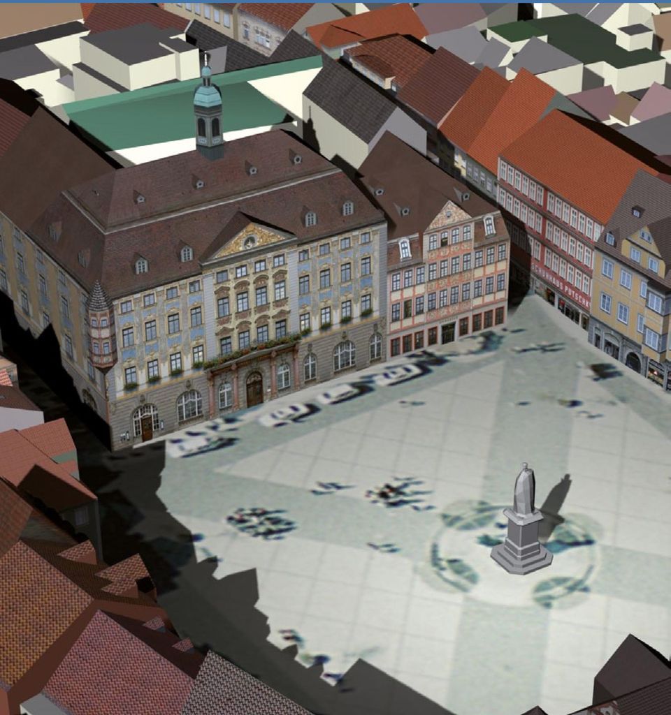
5 3D Spatial Information Systems With the CityServer3D the users from various application domains have a common basis to make consolidated decisions. A continuously updated city model allows the users to administrate, plan, present and analyze spatial information much easier. Our world is more and more digitially captured in 3D. People exceedingly use 3D models for their purposes. Examples can be found in urban planning, tourism or knowledge transfer. We have developed technologies that allow the users to efficiently manage, store and analyse 3D spatial data. Furthermore we model and visualize city and landscape models and provide services for quality assurance. Lifelike 3D city models with the CityServer3D Our work builds on the CityServer3D technology that we have been developing with partners and customers since The CityServer3D Suite consists of a spatial database, a server with numerous interfaces for the import and export of the data and applications for the development of landscape models. Administration software allows processing the data and the web viewer brings it onto the user s screen. Our customers from public services and industry successfully apply the CityServer3D in their daily business. Fraunhofer IGD advances the CityServer3D technology according the customers requirements as well as in research projects. Read more about CityServer3D at: With the CityServer3D the users administrate and integrate two- and three-dimensional spatial data. They can automatically generate three-dimensional models and carry out simulations in the 3D world. This information can be made available via standardized interfaces. Update and quality assurance features are integrated in the CityServer3D and can be adapted as needed. They ensure a sustainable usage and management of the data. 5

6 Spatial Data Infrastructures Our team develops individual SDI based solutions to provide users from different application fields with customized and up-to-date spatial information. Spatial data infrastructures (SDI) are used to exchange and process geographic information across various application areas, administrative boundaries and organizations. Our team supports you in the design and adoption of SDI-based solutions. We accompany the technical implementation and play a mediator role between end-users and IT experts. We also offer advice with selecting tools that match your requirements profiles. Integrate and harmonize spatial data with HALE The HUMBOLDT Alignment Editor (HALE) serves as an effective tool for the interactive and declarative schema mapping definition, which can be applied by spatial data providers and users. We have developed HALE together with our partners to support domain experts with generating and managing schema mappings. HALE exports schema mappings in different formats and uses them as basis for schema transformation. We have put special emphasis on the user friendliness, the mapping process management and on the documentation of mismatches in mappings. This is an important step towards the semantic harmonization of spatial data. HALE is freely available as an open source solution. Users are welcome to evaluate, apply and extend HALE. Further details on the HUMBOLDT Alignment Editor (HALE) are available at: The definition of schema mappings is a significant step towards the integration and harmonization of spatial data. Schema mapping links the elements of the schema of a data source to the elements of another schema. An example of such a transformation is the mapping from ALKIS (Amtliches Liegenschaftskataster-Informationssystem), the information system of the official German register of real estate, to the INSPIRE cadastral parcels scheme. Schema mappings between complex schemas are difficult to generate and to update. 6

7 7
8 Our expertise and service The Competence Center Spatial information Management brings in its know-how in research, consulting and implementation projects. Our core competences are 3D spatial information systems and spatial data infrastructures. Application-oriented initial research as basis for new products and services Our team participates in national and international research projects to develop and evaluate new methods and technologies for spatial information management. We also bring in our expertise in the coordination and management of research projects. Consultancy We elaborate concepts for customers from administration and industry. We acquire and analyse your requirements for drafting and evaluating a system. We analyse the feasibility and performance of a system of your choice. Furthermore, our Competence Center carries out market surveys. We work provider independently. Our current research topics include: Rule-based integration of distributed, heterogeneous spatial data sets, e.g. for the generation of 3D city models Semantics in 3D spatial data modelling and processing, especially the maintenance of semantics within the life cycle of 3D GIS objects 3D cartography for the visualization of integrated 2D and 3D data for different environments and application areas, e.g. noise and energy simulations, geology in the urban context, land management conflict strategies Quality of 3D city models Semantic interoperability and semantic annotation of data and services in spatial data infrastructures Implementation We are experienced in implementing and introducing software systems based on our own products or based on commercial solutions or open source tools. We offer flexible and customized financing and licensing models. 8

9 9

10 10

11 Cooperations & Boards The Competence Center Spatial Information Management is actively involved in the following boards and committees: Open Geospatial Consortium (OGC) Informations- und Kooperationsforum für Geodaten des ZGDV e.v. (InGeoForum) Deutscher Dachverband für Geoinformation e.v. (DDGI) European Umbrella Organisation for Geographic Information (EUROGI) Data Harmonisation Panel (DHP) Association of Geographic Information Laboratories for Europe (AGILE) Contact Dr. Eva Klien Head of the Competence Center Spatial Information Management Fraunhofer Institute for Computer Graphics Research IGD Fraunhoferstrasse Darmstadt, Germany Phone Fax geo@igd.fraunhofer.de The Competence Center Spatial Information Management connects visual computing with the geospatial community and provides the users with application-oriented solutions. 11

12

Cadastre in the context of SDI and INSPIRE
 Cadastre in the context of SDI and INSPIRE Dr. Markus Seifert Bavarian Administration for Surveying and Cadastre Cadastre in the digital age the approach in Germany 3 rd CLGE Conference, Hanover, 11.10.2012
How To Test For Anspire
 Network for testing GI services Anders Östman GIS Institute, University of Gävle, Nobelvägen 2, SE 80176, Gävle, Sweden Anders.Ostman@hig.se Abstract. The use of standards is essential when building a
GIS Implementation at the German Regional Public Administration Level
 GIS Implementation at the German Regional Public Administration Level Volker Emmel and Hartmut Mueller University of Applied Sciences, Mainz, Germany i3mainz Institute for Spatial Information and Surveying
Building a SDI for small countries the Portuguese example
 Building a SDI for small countries the Portuguese example Rui Pedro Julião Instituto Geográfico Português Deputy Director-General rpj@igeo.pt Abstract Portugal was one of the SDI pioneers in the beginning
Francesco Tortorelli
 Francesco Tortorelli Joint CEN/TC 287 and OGC Workshop Bringing GI Standards-making bodies together Frascati (Rome), 30 September 2013 (AgID) AgID (previously CNIPA and DigitPA) is a government agency
The Open Source Approach in Spatial Planning: Applicability Challenges in Bulgaria
 10th Network Conference The Role and Future of Spatial Planning in Central, Eastern and South-Eastern Europe 26-27 September 2013, Dresden The Open Source Approach in Spatial Planning: Applicability Challenges
INTERNATIONAL CONFERENCE: SDI & SIM 2013. Spatial Data Infrastructures & Spatial Information Management 2013
 INTERNATIONAL CONFERENCE: Spatial Data Infrastructures & Spatial Information Management 2013 And Commission 3 Annual Meeting The 2013 Annual 'FIG Commission 3' Workshop and Meeting is joined by the 'FIG
13 th EC GI & GIS Workshop WIN: A new OGC compliant SOA. for risk management. GMV, 2007 Property of GMV All rights reserved
 13 th EC GI & GIS Workshop WIN: A new OGC compliant SOA for risk management GMV, 2007 Property of GMV All rights reserved Content 1. Introduction 2. Objectives 3. Architecture and Model 4. Technical aspects
Solutions for Central and Federal Governments
 Solutions for Central and Federal Governments Intergraph s Advanced Geospatial Solutions for for Central and Federal Government Operations Central and federal governments are continually asked to do more
mdwfs Model-driven Schema Translation for Integrating Heterogeneous Geospatial Data
 mdwfs Model-driven Schema Translation for Integrating Heterogeneous Geospatial Data Tatjana Kutzner, Andreas Donaubauer Chair of Geoinformatics kutzner@tum.de INSPIRE KEN Schema Transformation Workshop,
SDI Workshop ESDIN Best Practices. 2011-06-28 INSPIRE conference, Edinburgh. Arnulf Christl, Metaspatial
 SDI Workshop ESDIN Best Practices 2011-06-28 INSPIRE conference, Edinburgh Arnulf Christl, Metaspatial Download this slide set as ODP (1.2MB) or PDF (1.1MB) at http://arnulf.us/publications Arnulf Christl
3D Point Cloud Analytics for Updating 3D City Models
 3D Point Cloud Analytics for Updating 3D City Models Rico Richter 25 th May 2015 INSPIRE - Geospatial World Forum 2015 Background Hasso Plattner Institute (HPI): Computer Graphics Systems group of Prof.
COSTE: a Web-Services Infrastructure Enabling Interoperability and Integration of Spatial and Traffic e-contents for European Regions
 COSTE: a Web-s Infrastructure Enabling Interoperability and Integration of Spatial and Traffic e-contents for European Regions Marco Boero Softeco Sismat SpA Italy Geographic Information: Motivation, problem
BuildingSMART International Infrastructure Room Work Plan 2015 Summary
 BuildingSMART International Infrastructure Room Work Plan 2015 Background There is a critical need for a comprehensive neutral data model capable of representing both semantic and geometric aspects of
SPATIAL DATA WEB SERVICES PRICING MODEL INRASTRUCTURE
 SPATIAL DATA WEB SERVICES PRICING MODEL INRASTRUCTURE L.Ozmus 1,B.Erkek 2,S.Colak 3, I.Cankurt 4 and S.Bakıcı 5 1 General Directorate of Land Registry and Cadastre, Ankara, Turkey, lozmus@gmail.com 2 General
INSPIRE INfrastructure for SPatial InfoRmation in Europe
 INSPIRE INfrastructure for SPatial InfoRmation in Europe Realisation Aspects at BEV in Austria Dr. techn. Markus Jobst Team INSPIRE/BEV Agenda INSPIRE common understanding at BEV/AT Infrastructure Framework
Andrea Buffam, Natural Resources Canada Canadian Metadata Forum National Library of Canada Ottawa, Ontario September 19 20, 2003
 Geospatial Metadata Andrea Buffam, Natural Resources Canada Canadian Metadata Forum National Library of Canada Ottawa, Ontario September 19 20, 2003 The Presentation - Geospatial Metadata This presentation
ISTANBUL DECLARATION ON CADASTRE IN THE WORLD CADASTRE SUMMIT 2015
 ISTANBUL DECLARATION ON CADASTRE IN THE WORLD CADASTRE SUMMIT 2015 Let us Cadastre the World... 1. INTRODUCTION Land had represented wealth and power from the first settlement to the end of 1700s. As a
National Geographic Information System (NGIS) in Korea
 in Korea") National Geographic Information System (NGIS) in Korea : from a national policy point of view Jongnam Choi Western Illinois University Geospatial Information Research Center Korea Research Institute for
National Geographic Information System (NGIS) in Korea : from a national policy point of view Jongnam Choi Western Illinois University Geospatial Information Research Center Korea Research Institute for
AdV Project: Map Production of DTK50 and DTK100 by Using Generalisation Processes
 Geoinformation und Landentwicklung AdV Project: Map Production of DTK50 and DTK100 by Using Generalisation Processes Sabine Urbanke, LGL Baden-Württemberg AdV- Project: The AAA Data Model Geodetic reference
Spatial Data Management Development of e-learning Modules
 Spatial Data Management Development of e-learning Modules Antje Krüger and Thomas Brinkhoff Institute for Applied Photogrammetry and Geoinformatics (IAPG) FH Oldenburg/Ostfriesland/Wilhelmshaven (University
Geospatial Project Management Portal
 Geospatial Project Management Portal Filiz Kurtcebe Altin, Tolga Kaya, Mehmet Bilgekagan Cintimur, Tugba Aydar Proline Integrated Intelligence Extended Abstract Conventional project management has difficulties
3D Client Software - Interactive, online and in real-time
 3D Client Software - Interactive, online and in real-time Dipl.Inform.Univ Peter Schickel CEO Bitmanagement Software Vice President Web3D Consortium, Mountain View, USA OGC/Web3D liaison manager Presentation
Intergraph Roadway Information Management Solution. Title Title. Title Title. A White Paper
 Intergraph Roadway Information Management Solution A White Paper Security, Government & Infrastructure, a division of Intergraph Title Title Title Title Table of Contents 1. Introduction... 1 2. Intergraph
THE SPATIAL DATA INFRASTRUCTURE OF SPAIN AS AN EXAMPLE OF SUCCESS IN EUROPE
 THE SPATIAL DATA INFRASTRUCTURE OF SPAIN AS AN EXAMPLE OF SUCCESS IN EUROPE Julio Mezcua-Rodríguez (jmezcua@fomento.es) Instituto Geográfico Nacional (National Geographic Institute). General Ibañez Ibero,
OPEN STANDARD WEB SERVICES FOR VISUALISATION OF TIME SERIES DATA OF FLOOD MODELS
 OPEN STANDARD WEB SERVICES FOR VISUALISATION OF TIME SERIES DATA OF FLOOD MODELS Barend Köbben FRMRC RPA 7 Workshop visualisations and flow simulations as flood risk communication tools
Collaborative Development of Knowledge Bases in Distributed Requirements Elicitation
 Collaborative Development of Knowledge Bases in Distributed s Elicitation Steffen Lohmann 1, Thomas Riechert 2, Sören Auer 2, Jürgen Ziegler 1 1 University of Duisburg-Essen Department of Informatics and
MSc Urban Planning E506 (Subject to Approval)
") MSc Urban Planning E506 (Subject to Approval) 1. Aim and Objectives to provide planners with knowledge, planning skills and the ability to adapt these to changing circumstances and the needs of society;
MSc Urban Planning E506 (Subject to Approval) 1. Aim and Objectives to provide planners with knowledge, planning skills and the ability to adapt these to changing circumstances and the needs of society;
PDOK Kaart, the Dutch Mapping API
 PDOK Kaart, the Dutch Mapping API Haico van der Vegt*, Leo van der Sluijs* * Cadastre, Land Registry and Mapping Agency of the Netherlands Abstract. PDOK (public services on the map) is a partnership of
Mobile GIS for Cadastral Data Collection in Ghana
 Mobile GIS for Cadastral Data Collection in Ghana Eric MENSAH OKANTEY Barend KÖBBEN 1 Introduction With the development of Web GIS and the emergence of Mobile GIS new possibilities of data capture and
SYLLABUS FOR RECRUITMENT TEST FOR THE POST OF ASSISTANT TOWN PLANNER (GROUP-A) IN TOWN & COUNTRY PLANNING DEPARTMENT, HARYANA
 IN TOWN & COUNTRY PLANNING DEPARTMENT, HARYANA") SYLLABUS FOR RECRUITMENT TEST FOR THE POST OF ASSISTANT TOWN PLANNER (GROUP-A) IN TOWN & COUNTRY PLANNING DEPARTMENT, HARYANA 1. MATERIALS AND PRINCIPLES OF CONSTRUCTION:- Site Development and Layouts,
SYLLABUS FOR RECRUITMENT TEST FOR THE POST OF ASSISTANT TOWN PLANNER (GROUP-A) IN TOWN & COUNTRY PLANNING DEPARTMENT, HARYANA 1. MATERIALS AND PRINCIPLES OF CONSTRUCTION:- Site Development and Layouts,
Three tools to facilitate online job matching throughout Europe. ESCO, EURES, Match & Map
 Three tools to facilitate online job matching throughout Europe ESCO, EURES, Match & Map Neither the European Union nor any person acting on behalf of the Commission may be held responsible for the use
Seminar on Polish & Danish Experiences June 2th 2015
 KMD Master Data KMD Master data management - Master data interoperability Seminar on Polish & Danish Experiences June 2th 2015 Nicolas Horst, Domain executive Lead AGENDA JUNE 2th 1. Trends and overview
DATA QUALITY AND SCALE IN CONTEXT OF EUROPEAN SPATIAL DATA HARMONISATION
 DATA QUALITY AND SCALE IN CONTEXT OF EUROPEAN SPATIAL DATA HARMONISATION Katalin Tóth, Vanda Nunes de Lima European Commission Joint Research Centre, Ispra, Italy ABSTRACT The proposal for the INSPIRE
Assessment of Workforce Demands to Shape GIS&T Education
 Assessment of Workforce Demands to Shape GIS&T Education Gudrun Wallentin, Barbara Hofer, Christoph Traun gudrun.wallentin@sbg.ac.at University of Salzburg, Dept. of Geoinformatics Z_GIS, Austria www.gi-n2k.eu
Geo-data Management Issues for Urban Land Administration in Turkey
 Arif Çağdaş AYDINOĞLU, Turkey Key words: e-governance, Geoinformation/GI, GIM; Land management, Standards SUMMARY Geographic (geo- prefix) data supports decision making in various application areas from
DIABLO VALLEY COLLEGE CATALOG 2016-2017
 Geography GEOGRAPHY GEOG Tish Young, Dean Physical Sciences and Engineering Division Physical Sciences Building, Room 263 Possible career opportunities Geography is an interdisciplinary study focusing
The International Hydrogeological Map of Europe ( IHME ) at the scale of 1:1.5 Million
 at the scale of 1:1.5 Million") The International Hydrogeological Map of Europe ( IHME ) at the scale of 1:1.5 Million - A coherent hydrogeological map for greater Europe and a model for the Rest of the World Historical Background State
The International Hydrogeological Map of Europe ( IHME ) at the scale of 1:1.5 Million - A coherent hydrogeological map for greater Europe and a model for the Rest of the World Historical Background State
THE RENEWAL OF SNIG UNDER INSPIRE UMBRELLA
 THE RENEWAL OF SNIG UNDER INSPIRE UMBRELLA GEIRINHAS, João; FONSECA, Alexandra; JULIÃO, Rui Pedro. joao.geirinhas@igeo.pt; afonseca@igeo.pt; rpj@igeo.pt Instituto Geográfico Português Abstract SNIG, the
Considerations of Data Quality Assurance Framework. Sue Gordon Acting Chief Executive
 Considerations of Data Quality Assurance Framework Sue Gordon Acting Chief Executive Hangzhou Forum on UN GGIM, 24-25 May 2012 Content NZ general background Who is LINZ? NZ strategic context & data quality
Technology Trends In Geoinformation
 Technology Trends In Geoinformation Dato Prof. Sr Dr. Abdul Kadir Bin Taib Department of Survey and Mapping Malaysia (JUPEM) Email: drkadir@jupem.gov.my www.jupem.gov.my NGIS 2008 3 rd. National GIS Conference
An Esri White Paper June 2011 ArcGIS for INSPIRE
 An Esri White Paper June 2011 ArcGIS for INSPIRE Esri, 380 New York St., Redlands, CA 92373-8100 USA TEL 909-793-2853 FAX 909-793-5953 E-MAIL info@esri.com WEB esri.com Copyright 2011 Esri All rights reserved.
E-Commerce and Property Planning
 FROM HYBRID MAPPING TO INTEGRATED QUERY AND PROCESSING: TWO SDI CASES FROM THE NETHERLANDS Marian de Vries and Theo Tijssen GIS Technology, Research Institute for Housing, Urban and Mobility Studies/ Faculty
Introduction to Service Oriented Architectures (SOA)
") Introduction to Service Oriented Architectures (SOA) Responsible Institutions: ETHZ (Concept) ETHZ (Overall) ETHZ (Revision) http://www.eu-orchestra.org - Version from: 26.10.2007 1 Content 1. Introduction
Introduction to Service Oriented Architectures (SOA) Responsible Institutions: ETHZ (Concept) ETHZ (Overall) ETHZ (Revision) http://www.eu-orchestra.org - Version from: 26.10.2007 1 Content 1. Introduction
What s new in Carmenta Server 4.2
 What s new in Carmenta Server 4.2 A complete solution for cost-effective visualisation and distribution of GIS data through web services Carmenta Server provides cost-effective technology for building
.FOR. Forest inventory and monitoring quality
 .FOR Forest inventory and monitoring quality FOR : the asset to manage your forest patrimony 2 1..FOR Presentation.FOR is an association of Belgian companies, created in 2010 and supported by a university
Stockholm, Rio, Århus, Inspire: Mapping-Out Environmental Information
 Stockholm, Rio, Århus, Inspire: Mapping-Out Environmental Information Thomas Pick Lower-Saxony Ministry for the Environment Thomas Vögele Coordination Center PortalU Themes Climate and Information Nature
Research Project GeoPortal
 Research Project GeoPortal Andreas Donaubauer Institute of Geodesy, GIS and Landmanagement, Prof. Schilcher of Munich of Munich Contents 1. Project GeoPortal at the of Munich 2. Results of the Project:
GetLOD - Linked Open Data and Spatial Data Infrastructures
 GetLOD - Linked Open Data and Spatial Data Infrastructures W3C Linked Open Data LOD2014 Roma, 20-21 February 2014 Stefano Pezzi, Massimo Zotti, Giovanni Ciardi, Massimo Fustini Agenda Context Geoportal
Creating common operational pictures for disaster response with collaborative work
 Risk Analysis IX 393 Creating common operational pictures for disaster response with collaborative work T. Chen, G. Su & H. Yuan Institute of Public Safety Research, Department of Physics Engineering,
可 视 化 与 可 视 计 算 概 论. Introduction to Visualization and Visual Computing 袁 晓 如 北 京 大 学 2015.12.23
 可 视 化 与 可 视 计 算 概 论 Introduction to Visualization and Visual Computing 袁 晓 如 北 京 大 学 2015.12.23 2 Visual Analytics Adapted from Jim Thomas s slides 3 Visual Analytics Definition Visual Analytics is the
Guidelines for Implementing the ISO 19100 Geographic Information Quality Standards in National Mapping and Cadastral Agencies
 Guidelines for Implementing the ISO 19100 Geographic Information Quality Standards in National Mapping and Cadastral Agencies edited by Antti Jakobsson, Jørgen Giversen www.eurogeographics.org INTRODUCTION
SERVICE ORIENTED ARCHITECTURES (SOA) AND WORKFLOWS NEED FOR STANDARDISATION?
 AND WORKFLOWS NEED FOR STANDARDISATION?") SERVICE ORIENTED ARCHITECTURES (SOA) AND WORKFLOWS NEED FOR STANDARDISATION? J-P. Evain European Broadcasting Union (EBU), Switzerland ABSTRACT This paper is an insight into what the EBU, the collective
SERVICE ORIENTED ARCHITECTURES (SOA) AND WORKFLOWS NEED FOR STANDARDISATION? J-P. Evain European Broadcasting Union (EBU), Switzerland ABSTRACT This paper is an insight into what the EBU, the collective
Clemens Portele interactive instruments GmbH
 GML - TU Delft - Standards in Action - 17.11.2004 GML Geography Markup Language Clemens Portele interactive instruments GmbH interactive instruments GmbH GML - TU Delft - Standards in Action - 17.11.2004
The Land Registration System in Italy Principles, organization and evolution. Aldo de Luca Central Director Land Registration and Legal Affairs
 The Land Registration System in Italy Principles, organization and evolution Aldo de Luca Central Director Land Registration and Legal Affairs Rome, November 20 th 2014 The principle of real consent: a
EPA PARCELS PROJECT. Cadastral Data Exchange and RESTful APIs. Funded by US EPA Grant 83431001. Prepared for EN2014
 EPA PARCELS PROJECT Cadastral Data Exchange and RESTful APIs Funded by US EPA Grant 83431001 Prepared for EN2014 February 20, 2014 2 Today s Topics Collaboration in North Carolina Parcels Business Case
eenvplus - eenvironmental services for advanced applications within INSPIRE
 eenvplus - eenvironmental services for advanced applications within INSPIRE CIP Pilot Actions Grant agreement no: 325232 Starting date: 01 January 2013 Giorgio Saio GISIG Key objective to support INSPIRE
Course description metadata (CDM) : A relevant and challenging standard for Universities
 : A relevant and challenging standard for Universities") Course description metadata (CDM) : A relevant and challenging standard for Universities The context : Universities, as knowledge factories have always been major players in the R&D on information and
Course description metadata (CDM) : A relevant and challenging standard for Universities The context : Universities, as knowledge factories have always been major players in the R&D on information and
EXPLORING AND SHARING GEOSPATIAL INFORMATION THROUGH MYGDI EXPLORER
 EXPLORING AND SHARING GEOSPATIAL INFORMATION THROUGH MYGDI EXPLORER Subashini Panchanathan Malaysian Centre For Geospatial Data Infrastructure ( MaCGDI ) Ministry of National Resources and Environment
Smart Cities require Geospatial Data Providing services to citizens, enterprises, visitors...
 Cloud-based Spatial Data Infrastructures for Smart Cities Geospatial World Forum 2015 Hans Viehmann Product Manager EMEA ORACLE Corporation Smart Cities require Geospatial Data Providing services to citizens,
The use of Semantic Web Technologies in Spatial Decision Support Systems
 The use of Semantic Web Technologies in Spatial Decision Support Systems Adam Iwaniak Jaromar Łukowicz Iwona Kaczmarek Marek Strzelecki The INSPIRE Conference 2013, 23-27 June Wroclaw University of Environmental
CONDIS. IT Service Management and CMDB
 CONDIS IT Service and CMDB 2/17 Table of contents 1. Executive Summary... 3 2. ITIL Overview... 4 2.1 How CONDIS supports ITIL processes... 5 2.1.1 Incident... 5 2.1.2 Problem... 5 2.1.3 Configuration...
Student Request to Hire Form
 Student Request to Hire Form Formatted: Left: 0.8", Right: 0.9" Note: Please complete all sections of this form Job Title: Division/Department/Location: GIS Summer Student GIS Services/Information Systems
Establishment of Spatial Data Infrastructure within the Environmental Sector in Slovak Republic
 EnviroInfo 2005 (Brno) Informatics for Environmental Protection - Networking Environmental Information Establishment of Spatial Data Infrastructure within the Environmental Sector in Slovak Republic Martin
Job mapping & matching
 Date 18.04.2011 1 Job mapping & matching Marinus de Bakker Coördinator CRIG / docent m.de.bakker@rug.nl Date 18.04.2011 2 Objective NL workshop Matching supply and demand same language (compare data standardisation)
COMOS Enterprise Server
 COMOS Enterprise Server White Paper Worldwide applications networking with service-oriented architecture August 2010 Summary Nowadays, interoperability is a must for the efficient planning and operation
Knowledge as a Service for Agriculture Domain
 Knowledge as a Service for Agriculture Domain Asanee Kawtrakul Abstract Three key issues for providing knowledge services are how to improve the access of unstructured and scattered information for the
Knowledge Management and Semantics in Global Grid User Support
 Knowledge Management and Semantics in Global Grid User Support T. Antoni (1), W. Bühler (1), H. Dres (1), G. Grein (1), T.Kamps (2), R. Kupsch (1), M. Roth (1), R.Stenzel (2) (1) Institute for Scientific
GO LIVE, ON TIME, ON BUDGET
 GO LIVE, ON TIME, ON BUDGET HOW TO OPTIMISE SAP Implementations AND UPGRADES THE PROBLEM IT leaders are familiar with demands-juggling ; a skill that reflects the success of IT. Business software systems
Fourth European Conference of Ministers responsible for the Cultural Heritage
 Fourth European Conference of Ministers responsible for the Cultural Heritage (Helsinki, 30-31 May 1996) Final Declaration and resolutions Meeting in Helsinki on 30-31 May 1996 for their 4th European conference,
GENASIS System Architecture
 GENASIS System Architecture On the way from environmental data repository towards research infrastructure Richard Hůlek, Jiří Jarkovský, Miroslav Kubásek, Jana Klánová, Jakub Gregor, Kateřina Šebková,
Doctor of Philosophy (Ph.D.), Major in. Geographic Information Science. Ph.D. Program. Educational Goal. Admission Policy. Advancement to Candidacy
, Major in. Geographic Information Science. Ph.D. Program. Educational Goal. Admission Policy. Advancement to Candidacy") Texas State University 1 Doctor of Philosophy (Ph.D.), Major in Geographic Information Science Ph.D. Program The course curriculum for the doctoral degree is designed to provide depth and breadth of knowledge
Texas State University 1 Doctor of Philosophy (Ph.D.), Major in Geographic Information Science Ph.D. Program The course curriculum for the doctoral degree is designed to provide depth and breadth of knowledge
Computational Cloud Services and Workflows for Agile Engineering
 Computational Cloud Services and Workflows for Agile Engineering THE CONCEPT WHAT S THE IDEA? The more products and product development integrate geometry, mechanics, electronics and software aspects,
Helsinki on a growth track
 BUI LDI NG HEL SIN KI Helsinki on a growth track With its rising population and the construction of large new residential and commercial areas, Finland s capital Helsinki will grow faster than ever in
CLOUDFLOW: COMPUTATIONAL CLOUD SERVICES AND WORKFLOWS FOR AGILE ENGINEERING
 CLOUDFLOW: COMPUTATIONAL CLOUD SERVICES AND WORKFLOWS FOR AGILE ENGINEERING André Stork, CloudFlow Co-ordinator Fraunhofer Institut für Graphische Datenverarbeitung IGD Fraunhoferstr. 5 64283 Darmstadt
A new web based elearning Platform for Building Simulation
 A new web based elearning Platform for Building Simulation Arne Abromeit 1, Andreas Wagner 1 Abstract The use of web based building simulation enables students to study building s performance under various
Next Generation Archives: The NC Geospatial Data Archiving Project
 Next Generation Archives: The NC Geospatial Data Archiving Project Jeff Essic North Carolina State University Libraries Zsolt Nagy North Carolina Center for Geographic Information and Analysis Coastal
Spatial Data Infrastructure. A Collaborative Network
 Spatial Data Infrastructure A Collaborative Network Solving Challenges Takes Collaboration Social challenges, environmental issues, and economic downturns all take cooperation to solve. Working together
Emerging Trends in SDI.
 Emerging Trends in SDI. Jeanne Foust ESRI gsdi 1 Spatial Data Infrastructure TRENDS GIS use continues to rapidly grow. Recognition Of GIS As Critical Infrastructure growing. Alignment of SDI and National
FreeGIS.net, INSPIRE, Open Source Software and OGC standards
 FreeGIS.net, INSPIRE, Open Source Software and OGC standards Workshop: How Open Source / Free Software and Open Standards complement each other in an SDI environment SFScon 13 Free Software Conference
Canadian Geospatial Data Infrastructure Vision, Mission and Roadmap - The Way Forward
 CANADIAN GEOSPATIAL DATA INFRASTRUCTURE CANADIAN GEOSPATIAL DATA INFRASTRUCTURE INFORMATION PRODUCT 28e Canadian Geospatial Data Infrastructure Vision, Mission and Roadmap - The Way Forward GeoConnections
CubeWerx USA. Role-based Access Control. Best Practices for Geospatial SOA. 2008 NSDI CAP Project. 2007, CubeWerx USA
 Role-based Access Control Best Practices for Geospatial SOA 2008 NSDI CAP Project Key Points Participants, Scope and Objectives Project Design Best Practices Use Case Examples Participants U.S. Army Corps
How To Write An Inspire Directive
 INSPIRE Infrastructure for Spatial Information in Europe Detailed definitions on the INSPIRE Network Services Title Detailed definitions on the INSPIRE Network Services Creator Date 2005-07-22 Subject
NEEDS ASSESSMENT FOR TRANSIT AND GIS DATA CLEARINGHOUSE
 NEEDS ASSESSMENT FOR TRANSIT AND GIS DATA CLEARINGHOUSE Prepared for Public Transit Office Florida Department of Transportation (FDOT) April 2011 Needs Assessment for Transit and GIS Data Clearinghouse
Geographical Information Systems with Remote Sensing
 SCHOOL OF SCIENCE Geographical Information Systems with Remote Sensing PGDip/MSc Medway Campus www.gre.ac.uk/science Why study this programme? Geographical Information Systems (GIS) and Remote Sensing
Page 1 CORPORATE PROFILE
 Page 1 CORPORATE PROFILE Who we are? Blau Advisors has become a model in consulting services rendering, due to its long-term commitment with clients. Project goal achievement and succeeding in client s
enabled society: a vision for 2025 From LADM/STDM to a spatially Jaap ZEVENBERGEN and Christiaan LEMMEN Peter VAN OOSTEROM, Harry UITERMARK,
 From LADM/STDM to a spatially enabled society: a vision for 2025 Harry UITERMARK, Peter VAN OOSTEROM, Jaap ZEVENBERGEN and Christiaan LEMMEN Introduction (1) Vision is a co-production Founding fathers
http://www.esri.com/bia
 ArcGIS for Tribal Transportation Management David Gadsden Federal Account Manager dgadsden@esri.com d d 1 David Gadsden GIS Background UW Geography (1995) Peace Corps Tanzania Environmental Social Science
Spatial Information Data Quality Guidelines
 Spatial Information Data Quality Guidelines Part of Victoria s Second Edition The Victorian Spatial Council was established under the Victorian Spatial Information Strategy 2004-2007 to support the advancement
Geo-information in The Hague & National SDI hub PDOK
 Geo-information in The Hague & National SDI hub PDOK dr.ir. Friso Penninga senior advisor at Municipality of The Hague & tactical advisor at Geonovum Contents 1. Introduction 2. GI in The Hague a. Overview
COURSE CATALOGUE 2013/2014
 COURSE CATALOGUE 2013/2014 Field: COMPUTER SCIENCE Programme: Master s Degree Programme in Advanced Programming and Databases Length of studies: 2 years (4 semesters) Number of ECTS Credits: 120 +20 for
Appendix I: Module Descriptions
 Appendix I: Module Descriptions Learning Outcomes AGI Propedeutics and Electives 856M11 18 ECTS Students are adjusting to the requirements of the MSc AGI programme based on their different first degrees.
GEOGRAPHIC CONTEXT ANALYSIS OF VOLUNTEERED INFORMATION
 GEOGRAPHIC CONTEXT ANALYSIS OF VOLUNTEERED INFORMATION (GEOCONAVI) Frank O. Ostermann COST Energic Meeting 26.05.2014, Zürich GEOGRAPHIC CONTEXT ANALYSIS OF VOLUNTEERED INFORMATION PRESENTATION OVERVIEW
Smart grid cyber security certification
 Smart grid cyber security certification 1 Introduction On 30th September 2014 ENISA organised a workshop where the results of the report on Smart grid security certification (to be published by end of
GEOGRAPHIC INFORMATION SYSTEMS
 GIS GEOGRAPHIC INFORMATION SYSTEMS FOR CADASTRAL MAPPING Chapter 6 2015 Cadastral Mapping Manual 6-0 GIS - GEOGRAPHIC INFORMATION SYSTEMS What is GIS For a long time people have sketched, drawn and studied
J48 Algebra And Spatial Data Mining - Models
 SEMANTIC DATA INTEGRATION ACROSS DIFFERENT SCALES: AUTOMATIC LEARNING OF GENERALIZATION RULES Birgit Kieler Institute of Cartography and Geoinformatics, Leibniz University of Hannover, Germany birgit.kieler@ikg.uni-hannover.de
Cloud Computing and Government Services August 2013 Serdar Yümlü SAMPAŞ Information & Communication Systems
 eenviper White Paper #4 Cloud Computing and Government Services August 2013 Serdar Yümlü SAMPAŞ Information & Communication Systems 1 Executive Summary Cloud computing could revolutionise public services
Welcome to ERGO Insurance Group
 Welcome to ERGO Insurance Group If people are looking for protection or provision, we almost certainly have a suitable solution in our wide-ranging portfolio. Above all, however, we are on hand to answer
CityGML goes to Broadway
 CityGML goes to Broadway Thomas H. Kolbe, Barbara Burger, Berit Cantzler Chair of Geoinformatics thomas.kolbe@tum.de September 11, 2015 Photogrammetric Week 2015, Stuttgart The New York City Open Data
Service-Oriented Visualization of Virtual 3D City Models
 Service-Oriented Visualization of Virtual 3D City Models Authors: Jan Klimke, Jürgen Döllner Computer Graphics Systems Division Hasso-Plattner-Institut, University of Potsdam, Germany http://www.hpi3d.de