MODIS Collection-6 Standard Snow-Cover Products
|
|
|
- Shana Anderson
- 7 years ago
- Views:
Transcription
1 MODIS Collection-6 Standard Snow-Cover Products Dorothy K. Hall 1 and George A. Riggs 1,2 1 Cryospheric Sciences Laboratory, NASA / GSFC, Greenbelt, Md. USA 2 SSAI, Lanham, Md. USA

2 MODIS Collection-6 Standard Snow-Cover Products 500-m resolution daily snow cover at the swath level 500-m daily snow-cover tile products gridded to sinusoidal projection 5-km daily climate-modeling grid (CMG) snow cover 500-m 8-day composite snow-cover tile products gridded to sinusoidal projection 5-km 8-day composite climate-modeling grid (CMG) snow cover 5-km monthly snow cover New! 500 m and 5 km cloud-gap-filled (CGF) daily snow cover 500 m snow cover extent using surface reflectance input (improved accuracy in less-than-ideal viewing conditions)
 daily snow cover 500 m snow cover extent using surface reflectance input (improved accuracy in")
3 Terra MODIS Image of Snowstorm in the Northeastern U.S. Acquired on 28 December 2010

4 500-m resolution daily snow cover at the swath level Images acquired on 28 December 2010 showing the result of a major snowstorm in the northeastern United States. cloud Binary snowcover map cloud cloud Fractional snowcover map Low SCF cloud High SCF

5 500-m daily snow cover tile products gridded to sinusoidal projection cloud snow % snow cover Non-snow covered land MODIS Aqua true-color image (left) and fractional snow-cover map (right) acquired on December 23, 2011
 and fractional snow-cover map (right) acquired")
6 5-km 8-day composite climate-modeling grid (CMG) snow cover

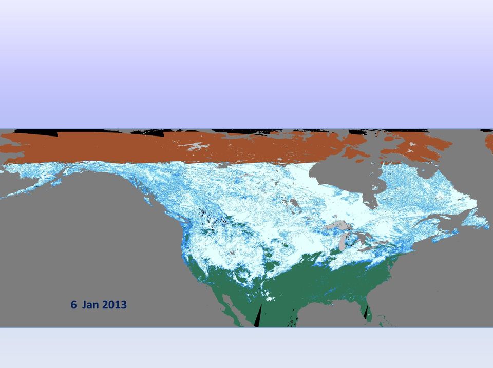
7 Sequence of MODIS Snow Maps (CGF) 1 6 January 2013 cloud 1 Jan 2013

8 2 Jan 2013

9 3 Jan 2013
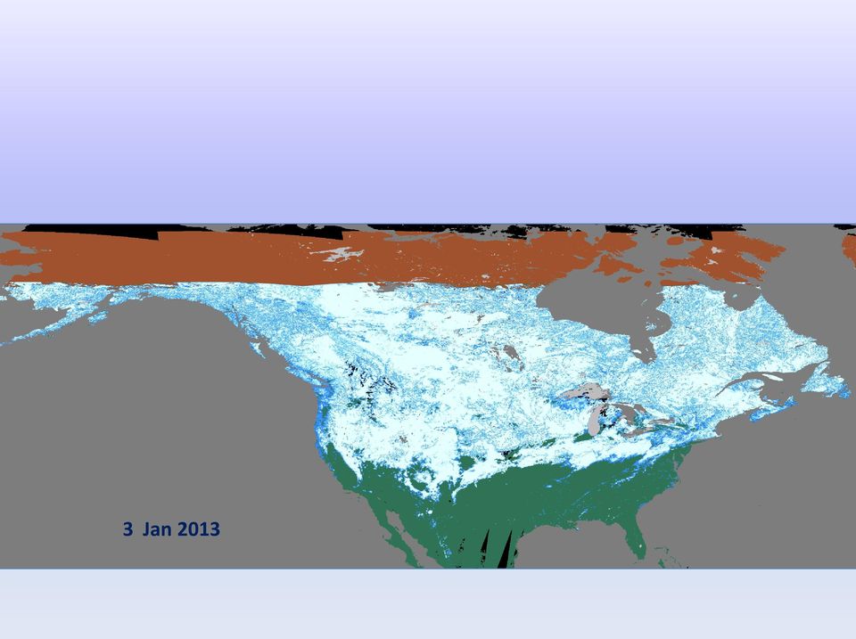
10 4 Jan 2013

11 5 Jan 2013

12 6 Jan 2013
13 New! 500 m cloud-gap-filled (CGF) daily snow cover Cloud-gap filled (CGF) cloud-persistence count (CPC) snow-cover map. The CPC provides quality assurance (QA) information in each pixel or cell.
")
14 Collection-6 (C6) Algorithm Improvements Dropped the binary snow product in C5 only fractional snow algorithm will be provided using the full range of NDSI from ; no binary product will be distributed; Dropped the surface temperature screen that erroneously reversed snow detection on mountains during spring and summer in C5; Added new screens to alleviate snow commission errors; Increased data information content in the QA data to enable better evaluation of the snow cover; QA flags set for screens applied.

15 Deleterious Effect of the C5 Surface-Temperature Screen on Spring Snow-Cover Mapping in the Sierra Nevada Mts., USA Collection 6 FSC Map Collection 5 FSC Map C5 / C6 difference Red shows how much snow was not mapped due to the temperature screen in C5 3 May 2010

16 Some Uses of the MODIS Snow- Cover Products Hydrology : for development of snow-cover depletion curves; Climatology: for monitoring snow cover extent and duration; Modeling: validation of model output and updating surface variables.

17 Suomi Visible Infrared Imaging Radiometer Suite (VIIRS) Snow-Cover Products Suomi NPP with VIIRS was launched in October 2012; VIIRS binary snow-cover algorithm based on the MODIS algorithm; Higher spatial resolution than MODIS (375 m); No pixel distortion across a scan; Wider swath, no orbit gaps compared to MODIS; Primarily for operational user community; NASA developing EDRs for climate science ; Expected continuity with MODIS to make CDRs.

18 VIIRS Snow-Cover Maps 12 February 2012 Left binary snow map Right fractional snowcover map

19 Continuation of MODIS and VIIRS snow data records Reprocessing will begin in 2013 for MODIS Collection 6 (C6) for both the Terra and Aqua snow-cover products; Major features of Collection 6: Surface temperature screen has been removed, allowing improved mapping of spring snow cover; A daily cloud-gap-filled (CGF) snow-cover product will be available; Reduction in snow commission errors with new screens applied; Surface reflectance based algorithm may slightly increase accuracy of snow cover detection. Suomi Visible Infrared Imaging Radiometer Suite (VIIRS) snow-cover products are continuing the MODIS snow-cover algorithms (at least for the binary product); How long will the MODIS instruments operate? Transition from MODIS to VIIRS record will occur sometime?? in the future.
 snow-cover products are continuing the MODIS snow-cover algorithms (at least for the binary product); How long will the MODIS instruments")
Suomi / NPP Mission Applications Workshop Meeting Summary
 Suomi / NPP Mission Applications Workshop Meeting Summary Westin City Center, Washington, DC June 21-22, 2012 Draft Report (updated March 12, 2013) I. Background The Suomi National Polar- orbiting Partnership
Satellite Snow Monitoring Activities Project CRYOLAND
 Satellite Snow Monitoring Activities Project CRYOLAND Background material for participants to the Workshop on European Snow Monitoring Perspectives, Darmstadt, 4-5 December 2012. CryoLand provides Snow,
Using Remote Sensing to Monitor Soil Carbon Sequestration
 Using Remote Sensing to Monitor Soil Carbon Sequestration E. Raymond Hunt, Jr. USDA-ARS Hydrology and Remote Sensing Beltsville Agricultural Research Center Beltsville, Maryland Introduction and Overview
Data Processing Flow Chart
 Legend Start V1 V2 V3 Completed Version 2 Completion date Data Processing Flow Chart Data: Download a) AVHRR: 1981-1999 b) MODIS:2000-2010 c) SPOT : 1998-2002 No Progressing Started Did not start 03/12/12
MOD09 (Surface Reflectance) User s Guide
 User s Guide") MOD09 (Surface ) User s Guide MODIS Land Surface Science Computing Facility Principal Investigator: Dr. Eric F. Vermote Web site: http://modis-sr.ltdri.org Correspondence e-mail address: mod09@ltdri.org
MOD09 (Surface ) User s Guide MODIS Land Surface Science Computing Facility Principal Investigator: Dr. Eric F. Vermote Web site: http://modis-sr.ltdri.org Correspondence e-mail address: mod09@ltdri.org
Department of Atmospheric Science/NASA Short-term Prediction Research and Transition (SPoRT) Center, Huntsville, Alabama 2
 Center, Huntsville, Alabama 2") J8.5 DEVELOPMENT OF A NEAR-REAL TIME HAIL DAMAGE SWATH IDENTIFICATION ALGORITHM FOR VEGETATION Jordan R. Bell 1, Andrew L. Molthan 2, Lori A. Schultz 3, Kevin M. McGrath 4, Jason E. Burks 2 1 Department
J8.5 DEVELOPMENT OF A NEAR-REAL TIME HAIL DAMAGE SWATH IDENTIFICATION ALGORITHM FOR VEGETATION Jordan R. Bell 1, Andrew L. Molthan 2, Lori A. Schultz 3, Kevin M. McGrath 4, Jason E. Burks 2 1 Department
Joint Polar Satellite System (JPSS)
") Joint Polar Satellite System (JPSS) John Furgerson, User Liaison Joint Polar Satellite System National Environmental Satellite, Data, and Information Service National Oceanic and Atmospheric Administration
Joint Polar Satellite System (JPSS) John Furgerson, User Liaison Joint Polar Satellite System National Environmental Satellite, Data, and Information Service National Oceanic and Atmospheric Administration
ADAGUC & PyTROLL. Maarten Plieger Ernst de Vreede. Application of polar orbiter products in weather forecasting Using open source tools and standards
 Application of polar orbiter products in weather forecasting Using open source tools and standards ADAGUC & PyTROLL Maarten Plieger Ernst de Vreede Royal Netherlands Meteorological Institute (KNMI) R&D
STAR Algorithm and Data Products (ADP) Beta Review. Suomi NPP Surface Reflectance IP ARP Product
 Beta Review. Suomi NPP Surface Reflectance IP ARP Product") STAR Algorithm and Data Products (ADP) Beta Review Suomi NPP Surface Reflectance IP ARP Product Alexei Lyapustin Surface Reflectance Cal Val Team 11/26/2012 STAR ADP Surface Reflectance ARP Team Member
STAR Algorithm and Data Products (ADP) Beta Review Suomi NPP Surface Reflectance IP ARP Product Alexei Lyapustin Surface Reflectance Cal Val Team 11/26/2012 STAR ADP Surface Reflectance ARP Team Member
Obtaining and Processing MODIS Data
 Obtaining and Processing MODIS Data MODIS is an extensive program using sensors on two satellites that each provide complete daily coverage of the earth. The data have a variety of resolutions; spectral,
GLOBAL FORUM London, October 24 & 25, 2012
 GLOBAL FORUM London, October 24 & 25, 2012-1 - Global Observations of Gas Flares Improving Global Observations of Gas Flares With Data From the Suomi NPP Visible Infrared Imaging Radiometer Suite (VIIRS)
Automated Spacecraft Scheduling The ASTER Example
 Automated Spacecraft Scheduling The ASTER Example Ron Cohen ronald.h.cohen@jpl.nasa.gov Ground System Architectures Workshop 2002 Jet Propulsion Laboratory The Concept Scheduling by software instead of
Temporal variation in snow cover over sea ice in Antarctica using AMSR-E data product
 Temporal variation in snow cover over sea ice in Antarctica using AMSR-E data product Michael J. Lewis Ph.D. Student, Department of Earth and Environmental Science University of Texas at San Antonio ABSTRACT
163 ANALYSIS OF THE URBAN HEAT ISLAND EFFECT COMPARISON OF GROUND-BASED AND REMOTELY SENSED TEMPERATURE OBSERVATIONS
 ANALYSIS OF THE URBAN HEAT ISLAND EFFECT COMPARISON OF GROUND-BASED AND REMOTELY SENSED TEMPERATURE OBSERVATIONS Rita Pongrácz *, Judit Bartholy, Enikő Lelovics, Zsuzsanna Dezső Eötvös Loránd University,
CERES Edition 2 & Edition 3 Cloud Cover, Cloud Altitude and Temperature
 CERES Edition 2 & Edition 3 Cloud Cover, Cloud Altitude and Temperature S. Sun-Mack 1, P. Minnis 2, Y. Chen 1, R. Smith 1, Q. Z. Trepte 1, F. -L. Chang, D. Winker 2 (1) SSAI, Hampton, VA (2) NASA Langley
Welcome to NASA Applied Remote Sensing Training (ARSET) Webinar Series
 Webinar Series") Welcome to NASA Applied Remote Sensing Training (ARSET) Webinar Series Introduction to Remote Sensing Data for Water Resources Management Course Dates: October 17, 24, 31 November 7, 14 Time: 8-9 a.m.
Welcome to NASA Applied Remote Sensing Training (ARSET) Webinar Series Introduction to Remote Sensing Data for Water Resources Management Course Dates: October 17, 24, 31 November 7, 14 Time: 8-9 a.m.
A remote sensing instrument collects information about an object or phenomenon within the
 Satellite Remote Sensing GE 4150- Natural Hazards Some slides taken from Ann Maclean: Introduction to Digital Image Processing Remote Sensing the art, science, and technology of obtaining reliable information
Reprojecting MODIS Images
 Reprojecting MODIS Images Why Reprojection? Reasons why reprojection is desirable: 1. Removes Bowtie Artifacts 2. Allows geographic overlays (e.g. coastline, city locations) 3. Makes pretty pictures for
Estimating Firn Emissivity, from 1994 to1998, at the Ski Hi Automatic Weather Station on the West Antarctic Ice Sheet Using Passive Microwave Data
 Estimating Firn Emissivity, from 1994 to1998, at the Ski Hi Automatic Weather Station on the West Antarctic Ice Sheet Using Passive Microwave Data Mentor: Dr. Malcolm LeCompte Elizabeth City State University
Launch-Ready Operations Code Chain ESDT ShortNames, LongNames, and Generating PGE or Ingest Source
 Launch-Ready Operations Code Chain ESDT ShortNames, LongNames, and Generating PGE or Ingest Source Generating PGE Name/Description or Ingest Source Product ESDT ShortName Product ESDT LongName NPP_VMAE_L1
Enabling Science in the Cloud: A Remote Sensing Data Processing Service for Environmental Science Analysis
 Enabling Science in the Cloud: A Remote Sensing Data Processing Service for Environmental Science Analysis Catharine van Ingen 1, Jie Li 2, Youngryel Ryu 3, Marty Humphrey 2, Deb Agarwal 4, Keith Jackson
The USGS Landsat Big Data Challenge
 The USGS Landsat Big Data Challenge Brian Sauer Engineering and Development USGS EROS bsauer@usgs.gov U.S. Department of the Interior U.S. Geological Survey USGS EROS and Landsat 2 Data Utility and Exploitation
A comparison of NOAA/AVHRR derived cloud amount with MODIS and surface observation
 A comparison of NOAA/AVHRR derived cloud amount with MODIS and surface observation LIU Jian YANG Xiaofeng and CUI Peng National Satellite Meteorological Center, CMA, CHINA outline 1. Introduction 2. Data
CHOOSING THE MOST ACCURATE THRESHOLDS IN A CLOUD DETECTION ALGORITHM FOR MODIS IMAGERY
 CHOOSING THE MOST ACCURATE THRESHOLDS IN A CLOUD DETECTION ALGORITHM FOR MODIS IMAGERY TRACEY A. DORIAN National Weather Center Research Experiences for Undergraduates Program & Pennsylvania State University
VIIRS-CrIS mapping. NWP SAF AAPP VIIRS-CrIS Mapping
 NWP SAF AAPP VIIRS-CrIS Mapping This documentation was developed within the context of the EUMETSAT Satellite Application Facility on Numerical Weather Prediction (NWP SAF), under the Cooperation Agreement
Comparison of NOAA's Operational AVHRR Derived Cloud Amount to other Satellite Derived Cloud Climatologies.
 Comparison of NOAA's Operational AVHRR Derived Cloud Amount to other Satellite Derived Cloud Climatologies. Sarah M. Thomas University of Wisconsin, Cooperative Institute for Meteorological Satellite Studies
NASA Earth System Science: Structure and data centers
 SUPPLEMENT MATERIALS NASA Earth System Science: Structure and data centers NASA http://nasa.gov/ NASA Mission Directorates Aeronautics Research Exploration Systems Science http://nasascience.nasa.gov/
AATSR Technical Note. Improvements to the AATSR IPF relating to Land Surface Temperature Retrieval and Cloud Clearing over Land
 AATSR Technical Note Improvements to the AATSR IPF relating to Land Surface Temperature Retrieval and Cloud Clearing over Land Author: Andrew R. Birks RUTHERFORD APPLETON LABORATORY Chilton, Didcot, Oxfordshire
Evaluation of VIIRS cloud top property climate data records and their potential improvement with CrIS
 Evaluation of VIIRS cloud top property climate data records and their potential improvement with CrIS Dr. Bryan A. Baum (PI) Space Science and Engineering Center University of Wisconsin-Madison Madison,
Daily High-resolution Blended Analyses for Sea Surface Temperature
 Daily High-resolution Blended Analyses for Sea Surface Temperature by Richard W. Reynolds 1, Thomas M. Smith 2, Chunying Liu 1, Dudley B. Chelton 3, Kenneth S. Casey 4, and Michael G. Schlax 3 1 NOAA National
Moderate- and high-resolution Earth Observation data based forest and agriculture monitoring in Russia using VEGA Web-Service
 Moderate- and high-resolution Earth Observation data based forest and agriculture monitoring in Russia using VEGA Web-Service Sergey BARTALEV and Evgeny LOUPIAN Space Research Institute, Russian Academy
Cloud Masking and Cloud Products
 Cloud Masking and Cloud Products MODIS Operational Algorithm MOD35 Paul Menzel, Steve Ackerman, Richard Frey, Kathy Strabala, Chris Moeller, Liam Gumley, Bryan Baum MODIS Cloud Masking Often done with
Studying cloud properties from space using sounder data: A preparatory study for INSAT-3D
 Studying cloud properties from space using sounder data: A preparatory study for INSAT-3D Munn V. Shukla and P. K. Thapliyal Atmospheric Sciences Division Atmospheric and Oceanic Sciences Group Space Applications
Satellite derived Groundwater Storage Es4mates and Opportuni4es for Expanding Research in Arid Environments
 Satellite derived Groundwater Storage Es4mates and Opportuni4es for Expanding Research in Arid Environments NASA Ames DEVELOP Program Summer 2011 Amber Kuss, San Francisco State University William Brandt,
Ocean Level-3 Standard Mapped Image Products June 4, 2010
 Ocean Level-3 Standard Mapped Image Products June 4, 2010 1.0 Introduction This document describes the specifications of Ocean Level-3 standard mapped archive products that are produced and distributed
Amy K. Huff Battelle Memorial Institute huffa@battelle.org BUSINESS SENSITIVE 1
 Using NASA Satellite Aerosol Optical Depth Data to Create Representative PM 2.5 Fields for Use in Human Health and Epidemiology Studies in Support of State and National Environmental Public Health Tracking
Darrel L. Williams 1, Samuel N. Goward 2, and Ta9ana Loboda 2
 Darrel L. Williams 1, Samuel N. Goward 2, and Ta9ana Loboda 2 1 Global Science & Technology, Inc., 7855 Walker Drive, Suite 200, Greenbelt, MD 20770 2 U. of Maryland College Park, Department of Geographical
The MODIS online archive and on-demand processing
 The MODIS online archive and on-demand processing Edward Masuoka NASA Goddard Space Flight Center, Greenbelt, MD, USA Production Driven by Science Over the Terra and Aqua mission lifetimes, better calibration
Satellite'&'NASA'Data'Intro'
 Satellite'&'NASA'Data'Intro' Research'vs.'Opera8ons' NASA':'Research'satellites' ' ' NOAA/DoD:'Opera8onal'Satellites' NOAA'Polar'Program:'NOAA>16,17,18,19,NPP' Geosta8onary:'GOES>east,'GOES>West' DMSP'series:'SSM/I,'SSMIS'
High Resolution Information from Seven Years of ASTER Data
 High Resolution Information from Seven Years of ASTER Data Anna Colvin Michigan Technological University Department of Geological and Mining Engineering and Sciences Outline Part I ASTER mission Terra
Multiangle cloud remote sensing from
 Multiangle cloud remote sensing from POLDER3/PARASOL Cloud phase, optical thickness and albedo F. Parol, J. Riedi, S. Zeng, C. Vanbauce, N. Ferlay, F. Thieuleux, L.C. Labonnote and C. Cornet Laboratoire
Resolutions of Remote Sensing
 Resolutions of Remote Sensing 1. Spatial (what area and how detailed) 2. Spectral (what colors bands) 3. Temporal (time of day/season/year) 4. Radiometric (color depth) Spatial Resolution describes how
AAFC Medium-Resolution EO Data Activities for Agricultural Risk Assessment
 AAFC Medium-Resolution EO Data Activities for Agricultural Risk Assessment North American Drought Monitor (NADM) Ottawa, Ontario, Canada. October 15-17 2008. A. Davidson 1, A. Howard 1,2, K. Sun 1, M.
APPLICATION OF TERRA/ASTER DATA ON AGRICULTURE LAND MAPPING. Genya SAITO*, Naoki ISHITSUKA*, Yoneharu MATANO**, and Masatane KATO***
 APPLICATION OF TERRA/ASTER DATA ON AGRICULTURE LAND MAPPING Genya SAITO*, Naoki ISHITSUKA*, Yoneharu MATANO**, and Masatane KATO*** *National Institute for Agro-Environmental Sciences 3-1-3 Kannondai Tsukuba
Land Product Validation
 CEOS WGCV Land Product Validation Sub-Group Joanne Nightingale 1, Jaime Nickeson 1 & Gabriela Schaepman-Strub 2 ( 1 Sigma Space Corp / NASA GSFC, 2 University of Zurich) ~ With input from LPV Focus Group
Real-time Global Flood Monitoring and Forecasting using an Enhanced Land Surface Model with Satellite and NWP model based Precipitation
 Real-time Global Flood Monitoring and Forecasting using an Enhanced Land Surface Model with Satellite and NWP model based Precipitation Huan Wu,2, Robert F. Adler, 2, Yudong Tian, 2, George J. Huffman
5200 Auth Road, Camp Springs, MD 20746 USA 2 QSS Group Inc, Lanham, MD, USA
 P6.25 CO-LOCATION ALGORITHMS FOR SATELLITE OBSERVATIONS Haibing Sun 2, W. Wolf 2, T. King 2, C. Barnet 1, and M. Goldberg 1 1 NOAA/NESDIS/ORA 52 Auth Road, Camp Springs, MD 2746 USA 2 QSS Group Inc, Lanham,
Received in revised form 24 March 2004; accepted 30 March 2004
 Remote Sensing of Environment 91 (2004) 237 242 www.elsevier.com/locate/rse Cloud detection in Landsat imagery of ice sheets using shadow matching technique and automatic normalized difference snow index
The RECOVER Cloud-Based Data Server
 2013 Intermountain GIS Conference - Boise, ID - March 11-13, 2013 The RECOVER Cloud-Based Data Server John Schnase, Roger Gill, Mark Carroll, Akiko Elders, and Molly Brown Keith Weber, George Haskett,
Item 4.1: Atmospheric Observation Panel for Climate Recent climatic events, observing-system changes and report from 17 th Session of AOPC
 SC-XX, 4-7 September 2012 Item 4.1: Atmospheric Observation Panel for Climate Recent climatic events, observing-system changes and report from 17 th Session of AOPC Adrian Simmons European Centre for Medium-Range
16 th IOCCG Committee annual meeting. Plymouth, UK 15 17 February 2011. mission: Present status and near future
 16 th IOCCG Committee annual meeting Plymouth, UK 15 17 February 2011 The Meteor 3M Mt satellite mission: Present status and near future plans MISSION AIMS Satellites of the series METEOR M M are purposed
The NASA NEESPI Data Portal to Support Studies of Climate and Environmental Changes in Non-boreal Europe
 The NASA NEESPI Data Portal to Support Studies of Climate and Environmental Changes in Non-boreal Europe Suhung Shen NASA Goddard Space Flight Center/George Mason University Gregory Leptoukh, Tatiana Loboda,
2.3 Spatial Resolution, Pixel Size, and Scale
 Section 2.3 Spatial Resolution, Pixel Size, and Scale Page 39 2.3 Spatial Resolution, Pixel Size, and Scale For some remote sensing instruments, the distance between the target being imaged and the platform,
Cloud detection and clearing for the MOPITT instrument
 Cloud detection and clearing for the MOPITT instrument Juying Warner, John Gille, David P. Edwards and Paul Bailey National Center for Atmospheric Research, Boulder, Colorado ABSTRACT The Measurement Of
Authors and Affiliations Kristopher Bedka 1, Cecilia Wang 1, Ryan Rogers 2, Larry Carey 2, Wayne Feltz 3, and Jan Kanak 4
 1. Title Slide Title: Analysis of the Co-Evolution of Total Lightning, Ground-Based Radar-Derived Fields, and GOES-14 1-Minute Super Rapid Scan Satellite Observations of Deep Convective Cloud Tops Authors
Development of an Integrated Data Product for Hawaii Climate
 Development of an Integrated Data Product for Hawaii Climate Jan Hafner, Shang-Ping Xie (PI)(IPRC/SOEST U. of Hawaii) Yi-Leng Chen (Co-I) (Meteorology Dept. Univ. of Hawaii) contribution Georgette Holmes
Review for Introduction to Remote Sensing: Science Concepts and Technology
 Review for Introduction to Remote Sensing: Science Concepts and Technology Ann Johnson Associate Director ann@baremt.com Funded by National Science Foundation Advanced Technological Education program [DUE
From hemispheric snow cover products towards an integrated view on the land cryosphere: Remote sensing & snow & carbon cycle
 From hemispheric snow cover products towards an integrated view on the land cryosphere: Remote sensing & snow & carbon cycle J. Pulliainen, K. Luojus, S. Metsämäki*, K. Rautiainen, J. Lemmetyinen, T. Ryyppö,
Mediterranean use of Medspiration: the CNR regional Optimally Interpolated SST products from MERSEA to MyOcean
 Mediterranean use of Medspiration: the CNR regional Optimally Interpolated SST products from MERSEA to MyOcean R.Santoleri 1, B.Buongiorno Nardelli 1, C.Tronconi 1, S.Marullo 2 1 CNR ISAC -Gruppo Oceanografia
Hyperspectral Satellite Imaging Planning a Mission
 Hyperspectral Satellite Imaging Planning a Mission Victor Gardner University of Maryland 2007 AIAA Region 1 Mid-Atlantic Student Conference National Institute of Aerospace, Langley, VA Outline Objective
Politecnico di Torino. Porto Institutional Repository
 Politecnico di Torino Porto Institutional Repository [Proceeding] Terrestrial Laser Scanner Acquisition For Snow Depth and Groundwater Recharge Quantification in an Alpine Basin Original Citation: Lavy,
How to Use the NOAA Enterprise Cloud Mask (ECM) Andrew Heidinger, Tom Kopp, Denis Botambekov and William Straka JPSS Cloud Team August 29, 2015
 Andrew Heidinger, Tom Kopp, Denis Botambekov and William Straka JPSS Cloud Team August 29, 2015") How to Use the NOAA Enterprise Cloud Mask (ECM) Andrew Heidinger, Tom Kopp, Denis Botambekov and William Straka JPSS Cloud Team August 29, 2015 Outline Describe ECM and its differences to VCM Describe
How to Use the NOAA Enterprise Cloud Mask (ECM) Andrew Heidinger, Tom Kopp, Denis Botambekov and William Straka JPSS Cloud Team August 29, 2015 Outline Describe ECM and its differences to VCM Describe
Establishing a Geospatial Intelligence Pipeline through Earth SySTEM Education
 Establishing a Geospatial Intelligence Pipeline through Earth SySTEM Education NOAA/NESDIS CoRP Science Symposium University of Maryland September 17, 2015 Peter Dorofy dorofyp@students.rowan.edu Rouzbeh
A review of cloud top height and optical depth histograms from MISR, ISCCP, and MODIS
 JOURNAL OF GEOPHYSICAL RESEARCH, VOL. 115,, doi:10.1029/2009jd013422, 2010 A review of cloud top height and optical depth histograms from MISR, ISCCP, and MODIS Roger Marchand, 1 Thomas Ackerman, 1 Mike
Forest Fire Information System (EFFIS): Rapid Damage Assessment
: Rapid Damage Assessment") Forest Fire Information System (EFFIS): Fire Danger D Rating Rapid Damage Assessment G. Amatulli, A. Camia, P. Barbosa, J. San-Miguel-Ayanz OUTLINE 1. Introduction: what is the JRC 2. What is EFFIS 3.
Forest Fire Information System (EFFIS): Fire Danger D Rating Rapid Damage Assessment G. Amatulli, A. Camia, P. Barbosa, J. San-Miguel-Ayanz OUTLINE 1. Introduction: what is the JRC 2. What is EFFIS 3.
Authors: Thierry Phulpin, CNES Lydie Lavanant, Meteo France Claude Camy-Peyret, LPMAA/CNRS. Date: 15 June 2005
 Comments on the number of cloud free observations per day and location- LEO constellation vs. GEO - Annex in the final Technical Note on geostationary mission concepts Authors: Thierry Phulpin, CNES Lydie
Satellite SST Product Development Proposal
 Call for Proposals under the IMOS (EIF) Five Year Strategy: Enhancement or extension of IMOS July 2009 to June 2013 Satellite SST Products Sub-Facility Plan Overview: Proposed Infrastructure Investment:
Severe Weather & Hazards Related Research at CREST
 Severe Weather & Hazards Related Research at CREST (Lead Scientists) Z. Johnny Luo, Nir Krakauer, Shayesteh Mahani, Fabrice Papa, Marouane Temimi and Brian Vant Hull (NOAA Collaborators) Arnold Gruber,
NCDC s SATELLITE DATA, PRODUCTS, and SERVICES
 **** NCDC s SATELLITE DATA, PRODUCTS, and SERVICES Satellite data and derived products from NOAA s satellite systems are available through the National Climatic Data Center. The two primary systems are
Providing drivers with actionable intelligence can minimize accidents, reduce driver claims and increase your bottom line. Equip motorists with the
 Providing drivers with actionable intelligence can minimize accidents, reduce driver claims and increase your bottom line. Equip motorists with the ability to make informed decisions based on reliable,
3.4 Cryosphere-related Algorithms
 3.4 Cryosphere-related Algorithms GLI Algorithm Description 3.4.-1 3.4.1 CTSK1 A. Algorithm Outline (1) Algorithm Code: CTSK1 (2) Product Code: CLFLG_p (3) PI Name: Dr. Knut Stamnes (4) Overview of Algorithm
Monitoring of Arctic Conditions from a Virtual Constellation of Synthetic Aperture Radar Satellites
 DISTRIBUTION STATEMENT A. Approved for public release; distribution is unlimited. Monitoring of Arctic Conditions from a Virtual Constellation of Synthetic Aperture Radar Satellites Hans C. Graber RSMAS
Outline. Case Study over Vale do Paraiba 11 February 2012. Comparison of different rain rate retrievals for heavy. Future Work
 Outline Short description of the algorithms for rain rate retrievals from passive microwave radiometers on board low-orbiting satellites (i.e., SSMI/S) Case Study over Vale do Paraiba 11 February 2012
Towards assimilating IASI satellite observations over cold surfaces - the cloud detection aspect
 Towards assimilating IASI satellite observations over cold surfaces - the cloud detection aspect Tuuli Perttula, FMI + Thanks to: Nadia Fourrié, Lydie Lavanant, Florence Rabier and Vincent Guidard, Météo
Operational snow mapping by satellites
 Hydrological Aspects of Alpine and High Mountain Areas (Proceedings of the Exeter Symposium, Juiy 1982). IAHS Publ. no. 138. Operational snow mapping by satellites INTRODUCTION TOM ANDERSEN Norwegian Water
Slide 1. Slide 2. Slide 3
 Satellite Analysis of Sea Surface Temperatures in the Florida Keys to Monitor Coral Reef Health NASA Stennis Space Center Earthzine/DEVELOP Virtual Poster Session, Summer 2011 Video Transcript Slide 1
SATELLITE IMAGES IN ENVIRONMENTAL DATA PROCESSING
 SATELLITE IMAGES IN ENVIRONMENTAL DATA PROCESSING Magdaléna Kolínová Aleš Procházka Martin Slavík Prague Institute of Chemical Technology Department of Computing and Control Engineering Technická 95, 66
Saharan Dust Aerosols Detection Over the Region of Puerto Rico
 1 Saharan Dust Aerosols Detection Over the Region of Puerto Rico ARLENYS RAMÍREZ University of Puerto Rico at Mayagüez, P.R., 00683. Email:arlenys.ramirez@upr.edu ABSTRACT. Every year during the months
Remote Sensing Satellite Information Sheets Geophysical Institute University of Alaska Fairbanks
 Remote Sensing Satellite Information Sheets Geophysical Institute University of Alaska Fairbanks ASTER Advanced Spaceborne Thermal Emission and Reflection Radiometer AVHRR Advanced Very High Resolution
Evaluating GCM clouds using instrument simulators
 Evaluating GCM clouds using instrument simulators University of Washington September 24, 2009 Why do we care about evaluation of clouds in GCMs? General Circulation Models (GCMs) project future climate
Comparison between current and future environmental satellite imagers on cloud classification using MODIS
 Remote Sensing of Environment 108 (2007) 311 326 www.elsevier.com/locate/rse Comparison between current and future environmental satellite imagers on cloud classification using MODIS Zhenglong Li a,, Jun
WORLD WIND JAVA for MODIS FIRE PRODUCTS VISUALIZATION (WWJF)
") WORLD WIND JAVA for MODIS FIRE PRODUCTS VISUALIZATION (WWJF) User Manual, v 1.0, April 2011 Luigi Boschetti, Alexandra Moulden and Michael Humber Department of Geography, University of Maryland, College
WORLD WIND JAVA for MODIS FIRE PRODUCTS VISUALIZATION (WWJF) User Manual, v 1.0, April 2011 Luigi Boschetti, Alexandra Moulden and Michael Humber Department of Geography, University of Maryland, College
A Project to Create Bias-Corrected Marine Climate Observations from ICOADS
 A Project to Create Bias-Corrected Marine Climate Observations from ICOADS Shawn R. Smith 1, Mark A. Bourassa 1, Scott Woodruff 2, Steve Worley 3, Elizabeth Kent 4, Simon Josey 4, Nick Rayner 5, and Richard
A SURVEY OF CLOUD COVER OVER MĂGURELE, ROMANIA, USING CEILOMETER AND SATELLITE DATA
 Romanian Reports in Physics, Vol. 66, No. 3, P. 812 822, 2014 ATMOSPHERE PHYSICS A SURVEY OF CLOUD COVER OVER MĂGURELE, ROMANIA, USING CEILOMETER AND SATELLITE DATA S. STEFAN, I. UNGUREANU, C. GRIGORAS
Advances in Cloud Imager Remote Sensing
 Advances in Cloud Imager Remote Sensing Andrew Heidinger NOAA/NESDIS/ORA Madison, Wisconsin With material from Mike Pavolonis, Robert Holz, Amato Evan and Fred Nagle STAR Science Symposium November 9,
Climate Extremes Research: Recent Findings and New Direc8ons
 Climate Extremes Research: Recent Findings and New Direc8ons Kenneth Kunkel NOAA Cooperative Institute for Climate and Satellites North Carolina State University and National Climatic Data Center h#p://assessment.globalchange.gov
A Microwave Retrieval Algorithm of Above-Cloud Electric Fields
 A Microwave Retrieval Algorithm of Above-Cloud Electric Fields Michael J. Peterson The University of Utah Chuntao Liu Texas A & M University Corpus Christi Douglas Mach Global Hydrology and Climate Center
Giovanni: A System for Rapid Access, Visualization and Analysis of Earth Science Data Online
 Giovanni: A System for Rapid Access, Visualization and Analysis of Earth Science Data Online Suhung Shen *, H. Rui, Z. Liu, T Zhu, L. Lu, S. Berrick, G. Leptoukh, W. Teng, J. Acker, J. Johnson, S. P. Ahmad,
CLOUD MASKING AND CLOUD PRODUCTS ROUNDTABLE EXPECTED PARTICIPANTS: ACKERMAN, HALL, WAN, VERMOTE, BARKER, HUETE, BROWN, GORDON, KAUFMAN, SCHAAF, BAUM
 CLOUD MASKING AND CLOUD PRODUCTS ROUNDTABLE EXPECTED PARTICIPANTS: ACKERMAN, HALL, WAN, VERMOTE, BARKER, HUETE, BROWN, GORDON, KAUFMAN, SCHAAF, BAUM NOMINAL PURPOSE: DISCUSSION OF TESTS FOR ACCURACY AND
Huai-Min Zhang & NOAAGlobalTemp Team
 Improving Global Observations for Climate Change Monitoring using Global Surface Temperature (& beyond) Huai-Min Zhang & NOAAGlobalTemp Team NOAA National Centers for Environmental Information (NCEI) [formerly:
Present Status of Coastal Environmental Monitoring in Korean Waters. Using Remote Sensing Data
 Present Status of Coastal Environmental Monitoring in Korean Waters Using Remote Sensing Data Sang-Woo Kim, Young-Sang Suh National Fisheries Research & Development Institute #408-1, Shirang-ri, Gijang-up,
Measurement of the effect of biomass burning aerosol on inhibition of cloud formation over the Amazon
 Supporting Online Material for Koren et al. Measurement of the effect of biomass burning aerosol on inhibition of cloud formation over the Amazon 1. MODIS new cloud detection algorithm The operational
Monitoring of Arctic Conditions from a Virtual Constellation of Synthetic Aperture Radar Satellites
 DISTRIBUTION STATEMENT A. Approved for public release; distribution is unlimited. Monitoring of Arctic Conditions from a Virtual Constellation of Synthetic Aperture Radar Satellites Hans C. Graber RSMAS
2. VIIRS SDR Tuple and 2Dhistogram MIIC Server-side Filtering. 3. L2 CERES SSF OPeNDAP dds structure (dim_alias and fixed_dim)
") MIIC Server-side Filtering Outline 1. DEMO Web User Interface (leftover from last meeting) 2. VIIRS SDR Tuple and 2Dhistogram MIIC Server-side Filtering 3. L2 CERES SSF OPeNDAP dds structure (dim_alias
MIIC Server-side Filtering Outline 1. DEMO Web User Interface (leftover from last meeting) 2. VIIRS SDR Tuple and 2Dhistogram MIIC Server-side Filtering 3. L2 CERES SSF OPeNDAP dds structure (dim_alias
Description of Scatterometer Data Products
 Scatterometer Data:// Description of Scatterometer Data Products QuikScat is no longer operational - last data recorded: 2009-Nov-23 REMSS QuikScat data set currently ends on 2009-11-19; data after that
Best practices for RGB compositing of multi-spectral imagery
 Best practices for RGB compositing of multi-spectral imagery User Service Division, EUMETSAT Introduction Until recently imagers on geostationary satellites were limited to 2-3 spectral channels, i.e.
Update on EUMETSAT ocean colour services. Ewa J. Kwiatkowska
 Update on EUMETSAT ocean colour services Ewa J. Kwiatkowska 1 st International Ocean Colour Science meeting, 6 8 May, 2013 EUMETSAT space data provider for operational oceanography Operational data provider
STUDY ON FOREST FIRE DETECTION WITH SATELLITE DATA
 STUDY ON FOREST FIRE DETECTION WITH SATELLITE DATA Mathias Milz Avdelning Rymdteknik Institutionen för System- och rymdteknik (SRT) Luleå tekniska universitet Kiruna March 8, 2013 1 Introduction Countries
Evaluation of the Effect of Upper-Level Cirrus Clouds on Satellite Retrievals of Low-Level Cloud Droplet Effective Radius
 Evaluation of the Effect of Upper-Level Cirrus Clouds on Satellite Retrievals of Low-Level Cloud Droplet Effective Radius F.-L. Chang and Z. Li Earth System Science Interdisciplinary Center University
Using Remotely Sensed Data From ASTER to Look Impact of Recent Earth Quakes in Gujarat, India.
 Using Remotely Sensed Data From ASTER to Look Impact of Recent Earth Quakes in Gujarat, India. A major earth quake occurred in Gujarat, India on January 26,2000. (Origin time 03:16 GMT, Location 23.399N