The Resilience of Nature. Mount St. Helens Eruption and Recovery
|
|
|
- Kristian Henderson
- 7 years ago
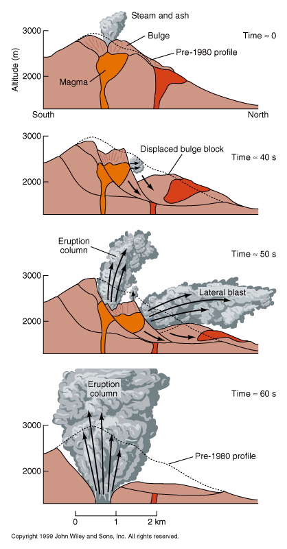
- Views:
Transcription

1 The Resilience of Nature Mount St. Helens Eruption and Recovery
2 Mount St. Helens Before the 1980 Eruption Photo taken from Norway Pass
3 Eruption
4 March 27, 1980 The 1980 Eruptive Period Begins
5 The Mountain Started Splitting
6 The Bulge
7
8 A 5.1 earthquake starts the avalanche Block two Block one
9


10 The Blast Begins Upward and Outward!
11 The Blast Spreads Northward
12
13 Ash Is Pushed Eastward Toward Yakima
14
15 Crystals in Volcanic Rock Minerals form into large crystals in volcanic rock that cools slowly. Minerals do not form crystals in volcanic rock that cools quickly. cools slowly cools quickly Granite < Dacite Obsidian (Mount St. Helens 1980)
16 Before Spirit Lake viewed from Norway Pass
17 After Lake bottom elevated 180 ft.
18 Spirit Lake


19 Mount St. Helens Eruption Damage
20 How big was it? Who Owned It? Acres Weyerhaeuser 68,000 Forest Service 64,000 State 12,000 Plum Creek Timber 5,000 Others 1,000 Total 150,000
21 The Lateral Blast Damage to Weyerhaeuser lands
22 Damaged Logging Equipment
23 Damaged Logging Equipment
24 Logging Tower and Loader Tower Boom of shovel
25 Log Loader
26 Fire Truck
27 Zone of Complete Destruction
28 Remains of Old Growth Forest
29 Blow-Down Zone
30
31 Standing Dead Zone
32 The Landslide and mudflow
33 Avalanche Debris Flow
34 The slide blocks Major Creeks Creating 2 New Lakes!
35 Hummock
36 New Pools and Hummocks
37 12 Road Shop
38 Weyerhaeuser s 12 Road Logging Camp
39 Crew Bus from Camp Baker
40 Weyerhaeuser Bridge
41 Seedling Cold Storage Camp Baker
42 Weyerhaeuser s Camp Baker
43 Camp Baker Equipment
44 19 Mile
45 State Highway Bridge
46 Weyerhaeuser s Campground
47 State Bridge Crossing the Toutle
48 Lower Toutle River
49 Mud Flow Leaves it s Mark
50 Interstate 5 Bridge
51 The mudflow Enters the Cowlitz River
52 Safety USGS Hot line Contingency Plan Flood Watch OSHA study PPE - Personal Protection Equipment Evacuation routes Emergency food supplies Road watering
53 Safety Starts with a Plan
54 24 hour Communications were critical!
55 Safety Equipment - PPE
56 Monitoring for Effects of Ash
57 Monitoring the Toutle River was crucial! River watchman at their station 24 hours a day Setting up river monitors
58 Watering Roads to Control Ash
59 Salvage Logging ,500 ACRES / 8,300 HECTARES 850 MILLION BOARD FEET/ 4.8 MILLION CUBIC METERS 1,000 PEOPLE
60 Dead Trees are Food for Insects
61 First Phase of River Salvage
62 Logs and Trees Pulled from River
63
64 Logs being Loaded
65
66 Salvage Operation 1981
67 Salvage of Standing Dead in the Blast Zone
68
69
70
71 Ash Boils Up as the Tree Hits the Ground
72 600 Truck Loads Per Day
73 Reforestation HAND-PLANTED 45,500 ACRES or 15,400 HECTARES 18,400,000 TREES DOUGLAS-FIR NOBLE FIR COTTONWOOD (RIPARIAN AREAS) LODGEPOLE PINE
74 18,400,000 Seedlings were Planted One By One 11 million Douglas-fir 7 million noble fir
75 Improved Seed from Our Seed Orchard
76 Weyerhaeuser seedlings Seedlings Grown in Our Nursery
77 Seedlings are Lifted, Bagged and Trucked to the Woods.
78 Planters Loading Up in the Morning
79 Noble-fir seedling
80 Trench dug to allow eroding ash to pass
81 June 1980 Minors Creek Monument Boundary
82 National Volcanic Monument Weyerhaeuser Douglas-fir 14 years old Minors Creek Monument Boundary
83 Shultz Creek Damage June 1980
84 Shultz Creek After Reforestation July 2002
85 Green River Reforestation Before
86 Green River Reforestation After July 2002
87 1980 Damage -10 miles North of Mountain (1)
88 The Area was Cut and Burned (2)
89 Planted in 1983 (3)
90 By 2002 the trees were well on their way (4)
91 Salvage and Regeneration on 3120 Road (1)
92 Regeneration on 3120 Road (2)
93 Weyerhaeuser Planted 1983 National Volcanic Monument The West Boundary between Weyerhaeuser and the National Volcanic Monument
94 Minors Creek Monument Boundary boundary Planted 1983
95 Recovery The Planted Forest Today
96 SOME TREES
97 Diameters 15 to 22 E:\Untitled-1.tif
98 First Commercial Thinning 2005
99 Delimbing
100 Forwarder

101 Fertilizing 36,000 acres
102 Renewal
103 Weyerhaeuser s Forest Learning Center at Mount St. Helens
104 THANK YOU
105 Important Research/Study Areas ASH COMOSITION/EROSION 130+ SPECIES OF ANIMALS COHO SALMON ELK PLANTS APPROXIMATELY 200 TOTAL STUDIES
106 A Bracken Fern Pushes Through the Ash
107 Natural Vegetation Study June 1980
108 Natural Vegetation after One Year
109 Studying Erosion
110 V-blade plow How can we move some of the ash?
111 Regeneration Studies
112 Migration of Roosevelt Elk into the Blast Zone
113 Elk Herd on Mudflow
114 Bird Survey Mountain blue bird
115 Amphibian Studies
116 Noble fir plant on Weyerhaeuser land
117 The Old Dome Inside the Crater of Mount St. Helens
118 New Dome behind old dome
119 Forest Learning Center At Mount St. Helens
120
121 . Portable Testing Equipment
122 Equipment Attached to Worker
123 Health Testing During Salvage Logging
Angora Fire Restoration Activities June 24, 2007. Presented by: Judy Clot Forest Health Enhancement Program
 Angora Fire Restoration Activities June 24, 2007 Presented by: Judy Clot Forest Health Enhancement Program California Tahoe Conservancy Independent California State Agency within the Resources Agency Governed
Post-Wildfire Clean-Up and Response in Houston Toad Habitat Best Management Practices
 Post-Wildfire Clean-Up and Response in Houston Toad Habitat Best Management Practices Purpose The purpose of this document is to provide guidance and recommendations for minimizing potential impacts to
Landslides. Landslides-1. March 2007
 Landslides Learn if landslides, including debris flows, could occur in your area by contacting local officials, your state geological survey or department of natural resources, or the geology department
Landslides & Mudflows
 1 2 - What is a Landslide? - Geologic hazard Common to almost all 50 states Annual global Billions in losses Thousands of deaths and injuries 3 1 - What is a Landslide? - Gravity is driving force Some
Landslides & Mudslides
 Landslides & Mudslides Landslides, also known as mudslides and debris flow, occur in all U.S. states and territories. In snowy mountainous areas winter snow landslides are called avalanches. Landslides
Earth Science Landforms, Weathering, and Erosion Reading Comprehension. Landforms, Weathering, and Erosion
 Reading Comprehension Name 1 How many people have been to the Rocky Mountains or the Grand Canyon? When people go to visit these natural wonders, they may not realize that it took millions of years for
3.1. Succession, Recovery, and Renewal in Natural Communities. A35 Starting Point. What Happens to a Vacant Lot?
 3.1 Succession, Recovery, and Renewal in Natural Communities Here is a summary of what you will learn in this section: Ecosystems change in predictable ways known as succession. Ecosystems can establish
REPORT TO REGIONAL WATER SUPPLY COMMISSION MEETING OF WEDNESDAY, SEPTEMBER 4, 2013 LEECH WATER SUPPLY AREA RESTORATION UPDATE
 Making a difference... together Agenda Item #9 REPORT #RWSC 2013-17 REPORT TO REGIONAL WATER SUPPLY COMMISSION MEETING OF WEDNESDAY, SEPTEMBER 4, 2013 SUBJECT LEECH WATER SUPPLY AREA RESTORATION UPDATE
King Fire Restoration Project, Eldorado National Forest, Placer and El Dorado Counties, Notice of intent to prepare an environmental impact statement.
 This document is scheduled to be published in the Federal Register on 12/24/2014 and available online at http://federalregister.gov/a/2014-30158, and on FDsys.gov [3410-11- P] DEPARTMENT OF AGRICULTURE
2009 Station Fire. Past. Present. Future. Successes and Challenges in Postfire Recovery
 2009 Station Fire Past Present Future Successes and Challenges in Postfire Recovery Jody Noiron, U.S. Forest Service - December 2010 Angeles National Forest Statistics: The most urban National Forest in
FORESTED VEGETATION. forests by restoring forests at lower. Prevent invasive plants from establishing after disturbances
 FORESTED VEGETATION Type of strategy Protect General cold adaptation upland and approach subalpine forests by restoring forests at lower Specific adaptation action Thin dry forests to densities low enough
, ~ The ResourcesAgency. Dave McNamara
 ,a! California State of California Department of Forestry, ~ The ResourcesAgency - ~A' ~;::~Af;// ~/ ~~/1Y~~,\~'(.~~~~~ ~,~ F1rl WES7:RY ~~~~_.~~- note 1416 Ninth Street Sacramento, CA 95814 Phone 916-445-5571
Arbor Day Tree Trivia
 Arbor Day Tree Trivia What day is Arbor Day? The last Friday of April. (April 30, 2010) Who is the father of Arbor Day? J. Sterling Morton When was the first Arbor Day? 1872 Name Idaho's state tree. Western
GEOTECHNICAL ISSUES OF LANDSLIDES CHARACTERISTICS MECHANISMS PREPARDNESS: BEFORE, DURING AND AFTER A LANDSLIDE QUESTIONS FOR DISCUSSIONS
 GEOTECHNICAL ISSUES OF LANDSLIDES CHARACTERISTICS MECHANISMS PREPARDNESS: BEFORE, DURING AND AFTER A LANDSLIDE QUESTIONS FOR DISCUSSIONS Huge landslide Leyte, Phillipines, 1998 2000 casulties Small debris
February 28 Earthquake: We got off easy
 February 28 Earthquake: We got off easy State Geologist John Beaulieu Lucky may not be the first word that comes to mind after an earthquake that injured more than 200 and caused more than $1 billion damage,
Volcanoes. Talking About Disaster: Guide for Standard Messages. Volcanoes-1. March 2007
 Volcanoes Learn about your community s risk from hazards created by volcanic eruptions. While you may be located far from a volcano, the ash from an explosive eruption could affect your area. Contact your
18 voting members 44 stakeholders 114 email list. Senators: Wyden & Merkley Representative DeFazio
 18 voting members 44 stakeholders 114 email list Senators: Wyden & Merkley Representative DeFazio State Representative Krieger State Senators: Roblan, Johnson, and Kruse Governor Brown s office County
Arizona s Large Fires Suppression vs. Restoration. WESTCAS Fall 2011 Meeting Bruce Hallin Manager, Water Rights and Contracts October 27, 2011
 Arizona s Large Fires Suppression vs. Restoration WESTCAS Fall 2011 Meeting Bruce Hallin Manager, Water Rights and Contracts October 27, 2011 THE PROBLEM Unhealthy Forests Since 2000, at least 1,501,654
2014 Feather River Post-Fire Restoration Reforestation
 Introduction and Location Feather River Post-Fire Restoration Reforestation Project USDA Forest Service Boise National Forest Mountain Home Ranger District Elmore County, Idaho The Mountain Home Ranger
Rapid Changes in Earth s Surface
 TEKS investigate rapid changes in Earth s surface such as volcanic eruptions, earthquakes, and landslides Rapid Changes in Earth s Surface Constant Changes Earth s surface is constantly changing. Wind,
ANGORA FIRE RESTORATION PROJECT
 ANGORA FIRE RESTORATION PROJECT U.S. Forest Service LAKE TAHOE BASIN MANAGEMENT UNIT Duncan Leao Vegetation Management Planner Richard Vacirca Forest Aquatics Biologist 3 PHASES OF FIRE REHAB Phase I Rehab:
Healthy Forests Resilient Water Supply Vibrant Economy. Ecological Restoration Institute
 Healthy Forests Resilient Water Supply Vibrant Economy Ecological Restoration Institute How Water Gets to Your Home MOST OF THE VALLEY S WATER SUPPLY comes from winter precipitation and runoff from Arizona
Chehalis River Basin Flood Damage Reduction 2013-2015 Capital Budget Approved by Legislature in June 2013
 Chehalis River Basin Flood Damage Reduction 2013-2015 Capital Budget Approved by Legislature in June 2013 1. Design alternatives for large capital flood projects (basinlevel water retention and Interstate
Tree and forest restoration following wildfire
 Peter F. Kolb (PhD) MSU Extension Forestry Specialist Adj. Assistant Professor Forest Ecology School of Forestry, University of Montana, Missoula, MT 59808 Tel. (406) 243-4705, e-mail: efpfk@forestry.umt.edu
PART I DEPARTMENT OF HUMAN RESOURCES DEVELOPMENT 9.097 STATE OF HAWAII 9.099... 9.101 9.103 Class Specifications 9.105 for the
 PART I DEPARTMENT OF HUMAN RESOURCES DEVELOPMENT 9.097 STATE OF HAWAII 9.099............................. 9.101 9.103 Class Specifications 9.105 for the FORESTRY AND WILDLIFE WORKER SERIES This series
4.0 Discuss some effects of disturbances on the forest.
 4.0 Discuss some effects of disturbances on the forest. 4.1 Describe common disturbances that occur in the Boreal forest. Disturbances are normal to the life of the forest. Forests are very resilient (able
This rain is known as acid rain.
 Rain is very important for life. All living things need water to live, even people. Rain brings us the water we need. But in many places in the world even where you live, rain has become a menace. Because
STANDARDS FOR RANGELAND HEALTH ASSESSMENT FOR SAGEHEN ALLOTMENT #0208
 STANDARDS FOR RANGELAND HEALTH ASSESSMENT FOR SAGEHEN ALLOTMENT #0208 RANGELAND HEALTH STANDARDS - ASSESSMENT SAGEHEN ALLOTMENT #0208 STANDARD 1 - UPLAND WATERSHED This standard is being met on the allotment.
Social and Environmental Impacts of Landslides
 Social and Environmental Impacts of Landslides Latsis Symposium 2007 Research Frontiers in Environment and Sustainability ETH-Zurich September 18, 2007 Dr. A. Keith Turner Emeritus Professor Geological
Fire, Forest History, and Ecological Restoration of Ponderosa Pine Forests at Mount Rushmore, South Dakota
 Fire, Forest History, and Ecological Restoration of Ponderosa Pine Forests at Mount Rushmore, South Dakota Restoration uses the past not as a goal but as a reference point for the future...it is not to
 Guide to Selling Your Timber ONCE YOU READ THIS GUIDE, YOU WILL KNOW: What to do if someone offers to buy your timber. How to get help in selling your timber. When trees are ready to sell. Why a contract
Introduction to Architecture. Lesson 13: Hoover Dam
 Introduction to Architecture Lesson 13: Hoover Dam Back in 2010, my family and I flew to California and then drove to the Grand Canyon via the Hoover Dam. Named after President Herbert Hoover, the Hoover
Communities and Biomes
 Name Date Class Communities and Biomes Section 3.1 Communities n your textbook, read about living in a community. Determine if the statement is true. f it is not, rewrite the italicized part to make it
Your Defensible Space Slideshow
 Your Defensible Space Slideshow Red = Trees to Remove Your Defensible Space Slideshow This slideshow was created to highlight actions you can take to dramatically improve the chances of your home surviving
Volcanoes and More: A Visit to Two National Parks in Hawaii
 VOA Special English is a daily news and information service for English learners. Read the story and then do the activities at the end. MP3s of stories can be found at voaspecialenglish.com Volcanoes and
Laboratory 6: Topographic Maps
 Name: Laboratory 6: Topographic Maps Part 1: Construct a topographic map of the Egyptian Pyramid of Khafre A topographic map is a two-dimensional representation of a three-dimensional space. Topographic
Arapaho & Roosevelt National Forests 2013 Flood: Long-term Recovery in a Changed Landscape
 Arapaho & Roosevelt National Forests 2013 Flood: Long-term Recovery in a Changed Landscape Spring 2014 The flood of September 2013 changed the landscape of the Boulder and Canyon Lakes Ranger Districts.
Climate, Vegetation, and Landforms
 Climate, Vegetation, and Landforms Definitions Climate is the average weather of a place over many years Geographers discuss five broad types of climates Moderate, dry, tropical, continental, polar Vegetation:
TECTONICS ASSESSMENT
 Tectonics Assessment / 1 TECTONICS ASSESSMENT 1. Movement along plate boundaries produces A. tides. B. fronts. C. hurricanes. D. earthquakes. 2. Which of the following is TRUE about the movement of continents?
UNITED STATES DEPARTMENT OF THE INTERIOR BUREAU OF LAND MANAGEMENT
 Form 1221-2 (June 1969) UNITED STATES DEPARTMENT OF THE INTERIOR BUREAU OF LAND MANAGEMENT MANUAL TRANSMITTAL SHEET Subject: BLM Manual 5716 Protective Measures Release 5-161 Date 7/7/15 1. Explanation
Let s Learn About Plants and Animals!
 Grade Two Pre-Visit Activities Let s Learn About Plants and Animals! i. Teacher Introduction ii. Standards Addressed iii. Pre-Visit Activities 1. Identifying Parts of a Plant 2. Plant a Seed 3. Life Cycles
PIPELINE ROUTING PERMIT. For A NATURAL GAS PIPELINE DAKOTA AND RAMSEY COUNTIES ISSUED TO NORTHERN STATES POWER COMPANY D/B/A XCEL ENERGY
 PIPELINE ROUTING PERMIT For A NATURAL GAS PIPELINE IN DAKOTA AND RAMSEY COUNTIES ISSUED TO NORTHERN STATES POWER COMPANY D/B/A XCEL ENERGY PUC DOCKET No. G002/GP-05-1706 In accordance with the requirements
Third Grade Science Vocabulary Investigation Design & Safety
 recycle dispose reuse goggles data conclusion predict describe observe record identify investigate evidence analyze mass matter float sink attract force magnet magnetic magnetism pole pull push repel Third
Plate Tectonics Web-Quest
 Plate Tectonics Web-Quest Part I: Earth s Structure. Use the following link to find these answers: http://www.learner.org/interactives/dynamicearth/structure.html 1. Label the layers of Earth in the diagram
Meet the Nonfiction Main Idea Challenge
 Meet the Nonfiction Main Idea Challenge What s the challenge? Students often give the topic or a fact as the main idea when they have read nonfiction. What students need to do to meet the MAIN IDEA requirement
WORKSHOP SUMMARY REPORT 1
 Climate Change Vulnerability Assessment & Adaptation Strategies for Sierra Nevada Resources Sierra Nevada Workshop Series October 14-17, 2014 WORKSHOP SUMMARY REPORT 1 Photo: ESA 1 Authors: Jessi Kershner
The rock cycle. Introduction. What are rocks?
 The rock cycle This Revision looks at the three types of rock: sedimentary, igneous and metamorphic. It looks at how they are formed, the weathering of rocks and the way one form of rock turns into another,
Wildfire & Flash Flood Recovery Emergency Watershed Protection (EWP) Flood Mitigation Efforts April 2014. Fall 2013
 Flood Mitigation Efforts April 2014. Fall 2013") Wildfire & Flash Flood Recovery Emergency Watershed Protection (EWP) Flood Mitigation Efforts April 2014 Fall 2013 Recovery Specific to Incident Recovery Efforts Depend on: Population Impacted Topography
Wildfire & Flash Flood Recovery Emergency Watershed Protection (EWP) Flood Mitigation Efforts April 2014 Fall 2013 Recovery Specific to Incident Recovery Efforts Depend on: Population Impacted Topography
6.E.2.2 Plate Tectonics, Earthquakes and Volcanoes
 Name: Date: 1. The road shown below was suddenly broken by a natural event. 3. The convergence of two continental plates would produce Which natural event most likely caused the crack in the road? island
Level E Placement Worksheet & Student Passage. Level 1 Placement Worksheet & Student Passage. Level 2 Placement Worksheet & Student Passage
 Placement Guide This guide will help you choose the right One Minute Reader level for your child. The ideal level is neither too easy nor too difficult. It should challenge the student without being frustrating.
REPUBLIC OF TURKEY MINISTRY OF FORESTRY AND WATER AFFAIRS
 REPUBLIC OF TURKEY MINISTRY OF FORESTRY AND WATER AFFAIRS Turkey s position in the World Prof. Dr. Veysel EROĞLU Minister of Forestry and Water Affairs The Ministry of Forestry and Water Affairs, formerly
NOTICE OF SALE. Department of Natural Resources & Conservation Timber Sale
 LINCOLN SILVER DOGWOOD TIMBER SALE NOTICE OF SALE Department of Natural Resources & Conservation Timber Sale The Lincoln Silver Dogwood Timber Sale is located within Sections 35 and 36, T19N-R30W on the
Focus On You Photography TRT from Brockway Summit to Watson Lake
 Tahoe Rim Trail (TRT) From Hwy 267 (Brockway Summit) west to Watson Lake (Strong Intermediate Advanced) This trail is very demanding. It is almost 2100 ft. of climbing. The trail is up and down, up and
FREQUENTLY ASKED QUESTIONS Biomass Harvest Guidelines
 FREQUENTLY ASKED QUESTIONS Biomass Harvest Guidelines What do Biomass Harvest Guidelines offer? They offer recommendations to manage forest-, brush- and open- land with the intent to protect water, timber,
Rimutaka Incline activity cards
 Rimutaka Incline activity cards To the supervisor As you lead your group on an exploration of the Rimutaka Incline, please ensure that the group stays together, treats the environment respectfully and
Revising the Nantahala and Pisgah Land Management Plan Preliminary Need to Change the Existing Land Management Plan
 Revising the Nantahala and Pisgah Land Management Plan Preliminary Need to Change the Existing Land Management Plan Throughout the Plan 1. There is a fundamental need for the revised plan to address how
Fry Phrases Set 1. TeacherHelpForParents.com help for all areas of your child s education
 Set 1 The people Write it down By the water Who will make it? You and I What will they do? He called me. We had their dog. What did they say? When would you go? No way A number of people One or two How
Division of Forestry
 Guidelines for Managing Sites with Ash To Address the Threat of Emerald Ash Borer On Forestry-Administered Lands BACKGROUND The ash genus (Fraxinus) in Minnesota comprises some 900 million trees and is
4. Plate Tectonics II (p. 46-67)
") 4. Plate Tectonics II (p. 46-67) Seafloor Spreading In the early 1960s, samples of basaltic ocean crust were dredged up from various locations across the ocean basins. The samples were then analyzed to
4. Plate Tectonics II (p. 46-67) Seafloor Spreading In the early 1960s, samples of basaltic ocean crust were dredged up from various locations across the ocean basins. The samples were then analyzed to
Unit 6 Earthquakes and Volcanoes
 Unit 6 Earthquakes and Volcanoes Earthquakes and Volcanoes: Essential Questions What evidence can students observe that the Earth is changing? How do scientists know what s inside the Earth? What processes
October 11, 2005. Sharon Stohrer State Water Resources Control board P.O. Box 2000 Sacramento, CA 95812-2000
 October 11, 2005 Sharon Stohrer State Water Resources Control board P.O. Box 2000 Sacramento, CA 95812-2000 Re: Maidu Cultural and Development Group CEQA Scoping Comments for the Environmental Impact Report
What You Should Know: Choosing a Consulting Forester
 Volume 2 Number 2 Spring 1998 What You Should Know: Choosing a Consulting Forester Private forest landowners sometimes need the assistance of a professional forester. The State of Utah Division of Forestry,
Using Google Earth to Explore Plate Tectonics
 Using Google Earth to Explore Plate Tectonics Laurel Goodell, Department of Geosciences, Princeton University, Princeton, NJ 08544 laurel@princeton.edu Inspired by, and borrows from, the GIS-based Exploring
Regents Questions: Plate Tectonics
 Earth Science Regents Questions: Plate Tectonics Name: Date: Period: August 2013 Due Date: 17 Compared to the oceanic crust, the continental crust is (1) less dense and more basaltic (3) more dense and
Appendix A: Affordable Housing Site Inventory
 Appendix A: Affordable Housing Site Inventory Following is a brief summary of the various sites considered for the Affordable Housing Project. Each site is provided with a photo when available and a concise
FIRST GRADE VOLCANOES 1 WEEK LESSON PLANS AND ACTIVITIES
 FIRST GRADE VOLCANOES 1 WEEK LESSON PLANS AND ACTIVITIES PLATE TECTONIC CYCLE OVERVIEW OF FIRST GRADE VOLCANOES WEEK 1. PRE: Learning the shapes of volcanoes. LAB: Experimenting with "lava." POST: Comparing
Mission Reach Self-Guided Tour Mission Concepción Portal Loop and Mission Reach Phase II Embayment Loop
 Mission Reach Self-Guided Tour Mission Concepción Portal Loop and Mission Reach Phase II Embayment Loop Welcome to the Mission Reach! The Mission Reach Ecosystem Restoration and Recreation Project is transforming
FOREST RESTORATION MONITORING TOOL
 FOREST RESTORATION MONITORING TOOL Draft version for field test INTRODUCTION FAO upon recommendation of its members identified the need to initiate a comprehensive analysis, evaluation and documentation
Past and Current Research on Natural Resource Issues in the Blue Mountains
 Past and Current Research on Natural Resource Issues in the Blue Mountains Recreation, Hunting, Access Livestock Production (and Wild Ungulate Ecology) Restoration Timber Harvest, Production Biodiversity,
Web of Water. Teacher s Guide Webisode 1 Blue Ridge
 Web of Water Teacher s Guide Webisode 1 Blue Ridge Table of Contents About Blue Ridge.... 3 South Carolina Science Standards.. 4 Discussion Questions.. 10 Knowitall Resources....... 13 Credits..... 14
Bengt Brunberg Manager Sustainability, BillerudKorsnäs Gävle, Sweden
 SUSTAINABILITY AND ENERGY SAVINGS Sustainable Supply of Wood Raw Material for Pulp Bengt Brunberg Manager Sustainability, BillerudKorsnäs Gävle, Sweden Bengt Brunberg experience is based on 15 years in
Restoring Land and Planting Trees
 198 11 Restoring Land and Planting Trees In this chapter: page Preventing erosion...200 Story: NGO workers learn about erosion from farmers... 201 Restoring damaged land...202 Natural succession...202
COMPARTMENT REVIEW RECORD OF CHANGES AND DECISIONS. Michigan Department of Natural Resources. Atlanta Management Unit. 2015 Year-of-Entry
 COMPARTMENT REVIEW RECORD OF CHANGES AND DECISIONS Michigan Department of Natural Resources Atlanta Management Unit 2015 Year-of-Entry Atlanta Field Office October 31, 2013 The following documents the
Modified Richter Scale
 Name Date ID Grade 7 - Science Interim Assessment Third Grading Period 1. Which of the following is NOT affected by the tilt of Earth's axis? Length of day Type of climate Change of seasons Length of year
Wildfire & Flash Flood Recovery NACo Justice & Public Safety Symposium January 2014
 Wildfire & Flash Flood Recovery NACo Justice & Public Safety Symposium January 2014 Fall 2013 Jim Reid Executive Director Public Service El Paso County, Colorado Recovery Specific to Incident Recovery
Restoration Ecology. A Bank of Tangled Definitions. Chuck Rhoades Rocky Mountain Res. Sta. Ft. Collins, Colorado. Chuck Rhoades
 Restoration Ecology A Bank of Tangled Definitions Chuck Rhoades Chuck Rhoades Rocky Mountain Res. Sta. Ft. Collins, Colorado Healthy Forest Restoration Act Provisions to expedite hazardous-fuel Reduction
Volcanoes Erupt Grade 6
 TEACHING LEARNING COLLABORATIVE (TLC) EARTH SCIENCE Volcanoes Erupt Grade 6 Created by: Debra McKey (Mountain Vista Middle School); Valerie Duncan (Upper Lake Middle School); and Lynn Chick (Coyote Valley
XVII. Science and Technology/Engineering, Grade 8
 VII. Science and Technology/Engineering, Grade 8 Grade 8 Science and Technology/Engineering Test The spring 2014 grade 8 Science and Technology/Engineering test was based on learning standards in the four
SAMPLE TIMBER SALE CONTRACT
 SAMPLE TIMBER SALE CONTRACT THE PARTIES OF THIS CONTRACT ARE AND HEREINAFTER CALLED PURCHASER. (Name and address of Purchaser) GENERAL TERMS 1. For, and in consideration of, the promises and agreements
www.irishseedsavers.ie Natural surface water on earth includes lakes, ponds, streams, rivers, estuaries, seas and oceans.
 www.irishseedsavers.ie POND LIFE FACT SHEET Natural surface water on earth includes lakes, ponds, streams, rivers, estuaries, seas and oceans. A pond is a small body of fresh water shallow enough for sunlight
Geospatial Software Solutions for the Environment and Natural Resources
 Geospatial Software Solutions for the Environment and Natural Resources Manage and Preserve the Environment and its Natural Resources Our environment and the natural resources it provides play a growing
Streambank stabilization, streambank fencing, nuisance species control, riparian zone management
 Streambank stabilization, streambank fencing, nuisance species control, riparian zone management Stream Restoration Cost Estimates BRIAN BAIR USDA Forest Service Gifford-Pinchot National Forest 1262 Hemlock
JUNIPER TREE NURSERY. Growing The Future Forest Today. A Promise We ve Been Keeping Since 1957.
 JUNIPER TREE NURSERY Growing The Future Forest Today. A Promise We ve Been Keeping Since 1957. JUNIPER TREE NURSERY J.D. Irving, Limited has had an active tree growing program since 1957 as part of our
Oregon. Climate Change Adaptation Framework
 Oregon Climate Change Adaptation Framework Oregon Environmental Quality Commission Climate Change Adaptation Framework Presentation at a glance: Purposes of the framework Participating agencies Climate
Geomorphology is the Study of Landforms. Usually by Erosion, Transportation and Deposition
 Geomorphology is the Study of Landforms and the Processes that t Create Them, Usually by Erosion, Transportation and Deposition Fluvial = running water, rivers and floodplains Glacial = flowing ice in
Wheat Farming: Then and Now
 Wheat Farming: Then and Now Written by Lisa Cocca California Education and the Environment Initiative History-Social Science Standard 2.4.1. Farming has changed in many ways. In 1900, farms needed many
Statement Rick D. Cables Rocky Mountain Regional Forester U.S. Forest Service United States Department of Agriculture
 Statement Rick D. Cables Rocky Mountain Regional Forester U.S. Forest Service United States Department of Agriculture Subcommittee on Forests and Forest Health Committee on Resources United States House
Western Forest Products Sustainable Forest Management System CAN/CSA Z809-2008
 Western Forest Products Sustainable Forest Management System CAN/CSA Z809-2008 Overview of Western Forest Products Forest Operations WFP holds the harvesting rights to 2 million hectares of Crown land
WEATHERING, EROSION, AND DEPOSITION PRACTICE TEST. Which graph best shows the relative stream velocities across the stream from A to B?
 NAME DATE WEATHERING, EROSION, AND DEPOSITION PRACTICE TEST 1. The diagram below shows a meandering stream. Measurements of stream velocity were taken along straight line AB. Which graph best shows the
Table A1. To assess functional connectivity of Pacific marten (Martes caurina) we identified three stand types of interest (open,
 we identified three stand types of interest (open,") Supplemental Online Appendix Table A1. To assess functional connectivity of Pacific marten (Martes caurina) we identified three stand types of interest (open, simple, complex) but divided these into subclasses
Supplemental Online Appendix Table A1. To assess functional connectivity of Pacific marten (Martes caurina) we identified three stand types of interest (open, simple, complex) but divided these into subclasses
LEAGUE NOTES ON APPROVED COMMUNITY WATER SUPPLY PLAN
 1 AUGUST 2011 LEAGUE NOTES ON APPROVED COMMUNITY WATER SUPPLY PLAN KEY ELEMENTS OF THE PLAN: 1. Replace the existing unsafe Ragged Mountain dam with a new dam and raise the reservoir pool level initially
HURRICANE IVAN Damage Appraisal & Recovery Efforts. Presentation produced by AFC (Walter E. Cartwright) WEB Address: www.forestry.alabama.
 WEB Address: www.forestry.alabama.") HURRICANE IVAN Damage Appraisal & Recovery Efforts Presentation produced by AFC (Walter E. Cartwright) WEB Address: www.forestry.alabama.gov Hurricane Ivan Struck 2:30 AM September 16, 2004 130 MPH winds
HURRICANE IVAN Damage Appraisal & Recovery Efforts Presentation produced by AFC (Walter E. Cartwright) WEB Address: www.forestry.alabama.gov Hurricane Ivan Struck 2:30 AM September 16, 2004 130 MPH winds
Streambank stabilization, streambank fencing, nuisance species control, riparian zone management
 Streambank stabilization, streambank fencing, nuisance species control, riparian zone management Stream Habitat Restoration Cost Considerations MARK COCKE, Civil Engineer Natural Resources Conservation
Deciduous Forest. Courtesy of Wayne Herron and Cindy Brady, U.S. Department of Agriculture Forest Service
 Deciduous Forest INTRODUCTION Temperate deciduous forests are found in middle latitudes with temperate climates. Deciduous means that the trees in this forest change with the seasons. In fall, the leaves
HFQLG Project Evaluation Form
 HFQLG Evaluation Form Names: Watershed Restoration Defensible Fuel Profile Zone Loyalton Pines Wildland Urban Interface Fuels Reduction Types: Watershed Restoration - Implemented pond and plug restoration
Fourth Grade Geology: The Earth and Its Changes Assessment
 Fourth Grade Geology: The Earth and Its Changes Assessment 1a. What is the center layer of the Earth called? a. crust b. core c. mantle d. middle 1b. Label each layer of the Earth. 1c. What are the Earth
Tectonic plates have different boundaries.
 KEY CONCEPT Plates move apart. BEFORE, you learned The continents join and break apart The sea floor provides evidence that tectonic plates move The theory of plate tectonics helps explain how the plates
Recovering From Wildfire A Guide for Oklahoma Forest Owners
 Wildfire! What Do I Do Now? Forestry Note: Recovering From Wildfire A Guide for Oklahoma Forest Owners Wildfire is the disaster many forest owners fear. If you are reading this, it has probably happened
Series 2016A-2 (Green Bonds) Final Proceeds Allocation April 2016
 Final Proceeds Allocation April 2016") Series 2016A-2 (Green Bonds) Final Proceeds Allocation April 2016 James L. McIntire Washington State Treasurer Summary The State of Washington offered green bonds to investors in September 2015, with approximately
Series 2016A-2 (Green Bonds) Final Proceeds Allocation April 2016 James L. McIntire Washington State Treasurer Summary The State of Washington offered green bonds to investors in September 2015, with approximately
CHAPTER I: INTRODUCTION. Background
 CHAPTER I: INTRODUCTION Background California State Law requires each county to adopt a General Plan for the physical development of the county and any land outside its boundaries which bears relation