Satellite Altimetry Missions
|
|
|
- Justin Bond
- 7 years ago
- Views:
Transcription

1 Satellite Altimetry Missions SINGAPORE SPACE SYMPOSIUM 30 TH SEPTEMBER 2015 AUTHORS: LUCA SIMONINI/ ERICK LANSARD/ JOSE M GONZALEZ


2 Table of Content General Principles and Applications Technology description Thales Alenia Space solutions 2

3 Radar Altimetry Principle Payload Data Precise Orbit Determination Dual Frequency Altimeter Or Ionospheric Models Microwave radiometer t=2r/c => 1 cm ~ 0.06 ns Microwave radar altimeter 3 3 End User Data Processing Data Processing Altimeter echo retracking Tropospheric correction Ionospheric correction POD

4 Mesoscale in the Oceans(time / space) 4

5 Themes (Operational/Science) Cryosphere Hydrology Ocean Sea Dynamic Topography Oceanic Circulation and Tides Modelling Acoustic communications Bathymetry Ocean Operational Forecasting 5

6 Dynamic Topography Dynamic topography is the sea level driven by thermodynamic processes in the ocean. It includes a "static" part (taking into account features like the main currents, etc.), and a variable part. 6

7 Oceanic Circulation and Tides Oceanic Circulation is the computation of speed and direction of ocean currents through the height gradient from the sea surface (The major ocean currents raise sea surface height) and the reference geoid. 7
 and the reference")
8 Modelling Acoustic Communications Acousticwavespeed dependson water pressure and T The soundpropagatesalong«channels» Someareas are «shadowed» 8

9 Altimetry & Bathymetry 1 km 4 km Non-linear transfer function between sea surface bottom topography and sea surface slope Altimetry Bathymetry is limited to km spatial wavelength 1 µrad slope (1 cm/10 km) = 1 mgal anomaly of gravity (10-5 m.s -2 ) 9
 = 1 mgal anomaly of gravity (10-5 m.")
10 Ocean Operational Forecasting Sea Surface Temperature(combined) Wind stress (scatterometers) Altimeter sea level anomaly Temperature Currents Tides Value Added Products for fishery, pollution, support to man atsea, defence, 10

11 Hydrology and Land Applications Reception of the return echoes on land is more complex. The backscatter coefficient depends on the state of the observed surface, according to whether it is covered by snow, vegetation, flooded areas, etc. Altimeters provide data on status of Lakes and Rivers for climate and water resources monitoring 11

 Data Processing of radar echo (retracking) Estimation of range, wave heights, backscattering, antenna pointing Altimeter measurement")
12 Key drivers for altimetry mission design Random noise in altimeter measurements Speckle and thermal noise Trade-off between along track spatial resolution (averaging of measurements) and geophysical product accuracy Signal to thermal noise ratio (Orbit height) Data Processing of radar echo (retracking) Estimation of range, wave heights, backscattering, antenna pointing Altimeter measurement stability Overall altimeter design Internal Calibration Modes External Calibration (ground proof) Temporal / Spatial sampling Orbit selection (tides, X-track distance vs repeat cycle) Number of satellites (constellation) Type of altimeters : nadir vs swath altimeters 12
 Number of satellites (constellation) Type of altimeters : nadir vs swath")
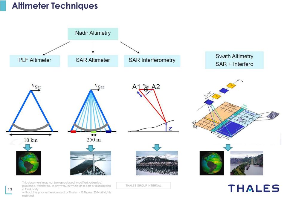
13 Altimeter Techniques 13
14 Pulse Altimeter The model is a convolution product of 3 terms The plane surface responding to a Dirac impulse (step) The distribution of the surface roughness (wind waves, tides, gravity perturbations) impulse response of the radar system (thermal noise, significant wave height (SWH), leading edge curvature, satellite or antenna mispointing, Antenna Gain) Ideally calm sea Rough sea 14
, leading edge curvature, satellite or antenna mispointing, Antenna Gain) Ideally calm sea")
15 SAR Altimeter Conventional Pulse Limited Altimeter 1. Non-coherent measurements 2. Real antenna aperture: D phys =1.2 m 3. Antenna Beamwidth and Footprint Θ synth 69º λ/d phys = 1.26º D foot_phys =720km Θ synth 16 km 4. Resolution enhancement based on priori knowledge on the topography (B=320 MHz) =2 /2 1.6km Altimeter with SAR mode 1. Coherent measurement over n pulses 2. Synthetic aperture: D synth >> D phys 3. Synthetic Antenna Beamwidth and footprint Θ synth 51º λ/ D synth = 0.022º D foot_synth =720km Θ synth km 4. Improvement of Signal to Noise Ratio by SAR processing ca. 10 db (B=320 MHZ) 5. Peak shape of the Echo, due the non constant surface ring of the signal Along Track Doppler Modulation Time delay 15
 5.")
16 Interferometer Altimeter Interferometry is used to better locate the echo reducing the noise Enhance the dynamics at high resolution Interferometric phase: Elevation: cosθ Difference in Elevation:! "! The interferometric phase noise depends on: Signal to thermal Noise Ratio Speckle noise (geometric decorrelation) Interferometric base attitude noise Range ambiguities Number of looks 16

17 A complete off-the-shelf Offer 17
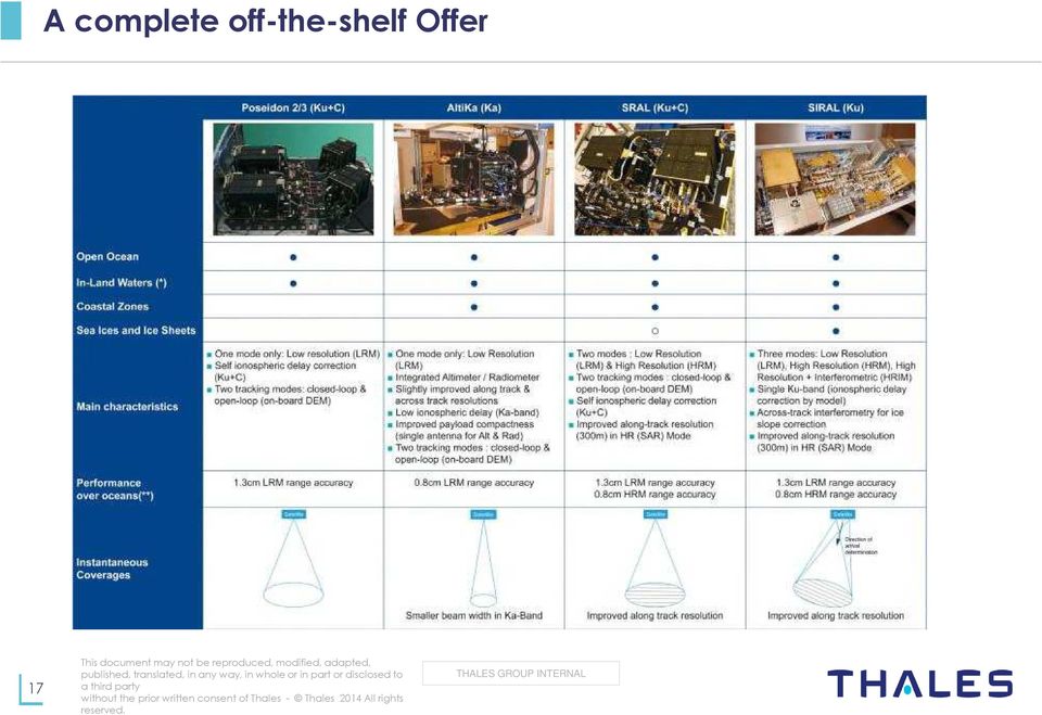
18 TAS Altimeters at a Glance Most altimeters in-orbit since 1990 are developed by Thales Alenia Space 30 years of altimeter development 20 years of successful in-orbit heritage Acknowledged expertise in end to end radar altimetry design Experience at Export 18

How To Monitor Sea Level With Satellite Radar
 Satellite Altimetry Wolfgang Bosch Deutsches Geodätisches Forschungsinstitut (DGFI), München email: bosch@dgfi.badw.de Objectives You shall recognize satellite altimetry as an operational remote sensing
Two primary advantages of radars: all-weather and day /night imaging
 Lecture 0 Principles of active remote sensing: Radars. Objectives: 1. Radar basics. Main types of radars.. Basic antenna parameters. Required reading: G: 8.1, p.401-40 dditional/advanced reading: Online
Günter Seeber. Satellite Geodesy 2nd completely revised and extended edition
 Günter Seeber Satellite Geodesy 2nd completely revised and extended edition Walter de Gruyter Berlin New York 2003 Contents Preface Abbreviations vii xvii 1 Introduction 1 1.1 Subject of Satellite Geodesy...
AltiKa Radiometer performance assessment
 AltiKa Radiometer performance assessment R. Rodriguez Suquet & N. Steunou, J.L. Courrière DCT/SI/AR 2 nd SARAL/AltiKa Science Workshop March 15 th -17 st, 2011 - AHMEDABAD 1 Overview Radiometer Instrument
Marine route optimization. Jens Olaf Pepke Pedersen Polar DTU / DTU Space www.polar.dtu.dk www.space.dtu.dk
 Marine route optimization Jens Olaf Pepke Pedersen Polar DTU / DTU Space www.polar.dtu.dk www.space.dtu.dk Early attempt at route optimization Jens Munk (1579-1628) Tries to find a way to India through
Satellite Derived Dynamic Ocean Currents in the Arctic. Jens Olaf Pepke Pedersen Polar DTU / DTU Space www.polar.dtu.dk www.space.dtu.
 Satellite Derived Dynamic Ocean Currents in the Arctic Jens Olaf Pepke Pedersen Polar DTU / DTU Space www.polar.dtu.dk www.space.dtu.dk Benefits of exploiting ocean currents Benjamin Franklins map of the
CryoSat Product Handbook
 CryoSat Product Handbook April 2012 ESRIN - ESA and Mullard Space Science Laboratory University College London Table of Content 1. Introduction... 5 1.1. Purpose and Scope of this User Guide... 5 1.2.
Radar Interferometric and Polarimetric Possibilities for Determining Sea Ice Thickness
 Radar Interferometric and Polarimetric Possibilities for Determining Sea Ice Thickness by Scott Hensley, Ben Holt, Sermsak Jaruwatanadilok, Jeff Steward, Shadi Oveisgharan Delwyn Moller, Jim Reis, Andy
SARAL ACCESS TO OFF-LINE DATA
 SARAL AltiKa introduction Plot of the SARAL/AltiKa ground track over Africa (Credits: Google). S ARAL/AltiKa is a new mission in cooperation between CNES and ISRO (Indian Space Research Organization),
Monitoring Soil Moisture from Space. Dr. Heather McNairn Science and Technology Branch Agriculture and Agri-Food Canada heather.mcnairn@agr.gc.
 Monitoring Soil Moisture from Space Dr. Heather McNairn Science and Technology Branch Agriculture and Agri-Food Canada heather.mcnairn@agr.gc.ca What is Remote Sensing? Scientists turn the raw data collected
RETRIEVING THE OCEAN WAVE-SKEWNESS FROM ENVISAT RA-2 AVERAGED WAVEFORMS
 RETRIEVING THE OCEAN WAVE-SKEWNESS FROM ENVISAT RA-2 AVERAGED WAVEFORMS Gómez-Enri, J. (1), Villares, P. (2), Gommenginger, C. (3), Srokosz, M. (4) Challenor, P. (5), Alonso, J.J (6), Arias, M. (7), Catalán
Algorithm Theoretical Basis Document (ATBD) of the CPP SAR numerical retracker for oceans
 of the CPP SAR numerical retracker for oceans") Réf. : S3A-NT-SRAL-00099-CNES Page : 1 / 16 Algorithm Theoretical Basis Document (ATBD) of the CPP SAR numerical retracker for oceans Nom et Sigle Date et Visa Rédigé par François BOY Thomas MOREAU (CLS)
Réf. : S3A-NT-SRAL-00099-CNES Page : 1 / 16 Algorithm Theoretical Basis Document (ATBD) of the CPP SAR numerical retracker for oceans Nom et Sigle Date et Visa Rédigé par François BOY Thomas MOREAU (CLS)
Введение в спутниковую радиолокацию: Радиолокаторы с синтезированной апертурой (РСА) Introduction to satellite radars: Synthetic Aperture Radars (SAR)
 Introduction to satellite radars: Synthetic Aperture Radars (SAR)") Введение в спутниковую радиолокацию: Радиолокаторы с синтезированной апертурой (РСА) Introduction to satellite radars: Synthetic Aperture Radars (SAR) проф. Бертран Шапрон IFREMER / ЛСО РГГМУ Prof. Bertrand
Введение в спутниковую радиолокацию: Радиолокаторы с синтезированной апертурой (РСА) Introduction to satellite radars: Synthetic Aperture Radars (SAR) проф. Бертран Шапрон IFREMER / ЛСО РГГМУ Prof. Bertrand
Satellite'&'NASA'Data'Intro'
 Satellite'&'NASA'Data'Intro' Research'vs.'Opera8ons' NASA':'Research'satellites' ' ' NOAA/DoD:'Opera8onal'Satellites' NOAA'Polar'Program:'NOAA>16,17,18,19,NPP' Geosta8onary:'GOES>east,'GOES>West' DMSP'series:'SSM/I,'SSMIS'
GNSS Reflectometry at GFZ: ocean altimetry and land surface monitoring
 GNSS Reflectometry at GFZ: ocean altimetry and land surface monitoring M. Semmling 1 S. Vey 1 J. Beckheinrich 1 V. Leister 1,2 J. Saynisch 1 J. Wickert 1 1 Research Centre for Geoscience GFZ, Potsdam 2
Active and Passive Microwave Remote Sensing
 Active and Passive Microwave Remote Sensing Passive remote sensing system record EMR that was reflected (e.g., blue, green, red, and near IR) or emitted (e.g., thermal IR) from the surface of the Earth.
European Space Agency EO Missions. Ola Gråbak ESA Earth Observation Programmes Tromsø, 17 October 2012
 European Space Agency EO Missions Ola Gråbak ESA Earth Observation Programmes Tromsø, 17 October 2012 Europe and Space, A POLICY Article 189 of the Lisbon Treaty (2009) gives the European Union an explicit
Astronomical applications of the over-the-horizon radar NOSTRADAMUS
 Astronomical applications of the over-the-horizon radar NOSTRADAMUS J-F. Degurse 1,2, J-Ph. Molinié 1, V. Rannou 1,S. Marcos 2 1 ONERA, Département Electromagnétisme et Radar 2 L2S Supéléc, CNRS UMR 8506,
What has 16 years of Satellite Radar Altimetry given us towards Global monitoring of the Earth s inland water resources?
 What has 16 years of Satellite Radar Altimetry given us towards Global monitoring of the Earth s inland water resources? P.A.M Berry (1), R.G.Smith (1), J.A.Freeman (1) 1. EAPRS Laboratory, De Montfort
How To Write A Call To Action For Terrasar-X
 Doc.: TX-PGS-PL-4127 TerraSAR-X Announcement of Opportunity: Utilization of the TerraSAR-X Archive 1 Page: 2 of 11 TABLE OF CONTENTS TERRASAR-X... 1 ANNOUNCEMENT OF OPPORTUNITY: UTILIZATION OF THE TERRASAR-X
Ocean surface currents: What can we do with Earth Observations?
 Ocean surface currents: What can we do with Earth Observations? G. Larnicol, G.Dibarboure, Y Faugère, I Pujol, S Labroue, C Dufau, MH Rio, Space Oceanography Division, CLS Globcurrent UCM 7-9 march, Brest
Weather Radar Basics
 Weather Radar Basics RADAR: Radio Detection And Ranging Developed during World War II as a method to detect the presence of ships and aircraft (the military considered weather targets as noise) Since WW
NASA Earth System Science: Structure and data centers
 SUPPLEMENT MATERIALS NASA Earth System Science: Structure and data centers NASA http://nasa.gov/ NASA Mission Directorates Aeronautics Research Exploration Systems Science http://nasascience.nasa.gov/
Jason-2 GDR Quality Assessment Report. Cycle 059 07-02-2010 / 17-02-2010. M. Ablain, CLS. P. Thibaut, CLS
 Jason-2 GDR Quality Assessment Report Cycle 059 07-02-2010 / 17-02-2010 Prepared by : S. Philipps, CLS M. Ablain, CLS P. Thibaut, CLS Accepted by : Approved by : DT/AQM, CLS E. Bronner, CNES Edition 01.0,
Radar images Università di Pavia Fabio Dell Acqua Gruppo di Telerilevamento
 Radar images Radar images radar image DNs linked to backscattered field Backscattered field depends on wave-target interaction, with different factors relevant to it: within-pixel coherent combination
Remote Sensing an Introduction
 Remote Sensing an Introduction Seminar: Space is the Place Referenten: Anica Huck & Michael Schlund Remote Sensing means the observation of, or gathering information about, a target by a device separated
Groundwater exploration WATEX applications with Ground Penetrating Radars. Dr.Saud Amer USGS Dr.Alain Gachet Radar Technologies France
 Groundwater exploration WATEX applications with Ground Penetrating Radars Dr.Saud Amer USGS Dr.Alain Gachet Radar Technologies France GPR is a technology that allows rapid and non destructive collection
Sentinel-1 Mission Overview
 Sentinel-1 Mission Overview Pierre Potin Sentinel-1 Mission Manager, ESA Advanced Course on Radar Polarimetry ESRIN, Frascati, 19 January 2011 Global Monitoring for Environment and Security GMES is established
DESIMETERSYSTEM FOR HØYNØYAKTIG POSISJONERING OG NAVIGASJON
 DESIMETERSYSTEM FOR HØYNØYAKTIG POSISJONERING OG NAVIGASJON John A. Vint Survey Manager Thales GeoSolutions Norge AS Hønefoss, 7. november 2003 Scope of Presentation Introduction Summary of GPS Errors.
Intra-seasonal and Annual variability of the Agulhas Current from satellite observations
 Intra-seasonal and Annual variability of the Agulhas Current from satellite observations Marjolaine Krug Ecosystem Earth Observation (CSIR NRE) Pierrick Penven Laboratoire de Physique des Océans (IRD)
Module 13 : Measurements on Fiber Optic Systems
 Module 13 : Measurements on Fiber Optic Systems Lecture : Measurements on Fiber Optic Systems Objectives In this lecture you will learn the following Measurements on Fiber Optic Systems Attenuation (Loss)
Monitoring a Changing Environment with Synthetic Aperture Radar. Alaska Satellite Facility National Park Service Don Atwood
 Monitoring a Changing Environment with Synthetic Aperture Radar Don Atwood Alaska Satellite Facility 1 Entering the SAR Age 2 SAR Satellites RADARSAT-1 Launched 1995 by CSA 5.6 cm (C-Band) HH Polarization
The European Space Agency s Synthetic Aperture Radar Programme From Experiment to Service Provision
 The European Space Agency s Synthetic Aperture Radar Programme From Experiment to Service Provision Evert Attema ESA, Directorate of Earth Observation Programme! The idea of an independent European space
16 th IOCCG Committee annual meeting. Plymouth, UK 15 17 February 2011. mission: Present status and near future
 16 th IOCCG Committee annual meeting Plymouth, UK 15 17 February 2011 The Meteor 3M Mt satellite mission: Present status and near future plans MISSION AIMS Satellites of the series METEOR M M are purposed
Antennas & Propagation. CS 6710 Spring 2010 Rajmohan Rajaraman
 Antennas & Propagation CS 6710 Spring 2010 Rajmohan Rajaraman Introduction An antenna is an electrical conductor or system of conductors o Transmission - radiates electromagnetic energy into space o Reception
Monitoring of Arctic Conditions from a Virtual Constellation of Synthetic Aperture Radar Satellites
 DISTRIBUTION STATEMENT A. Approved for public release; distribution is unlimited. Monitoring of Arctic Conditions from a Virtual Constellation of Synthetic Aperture Radar Satellites Hans C. Graber RSMAS
Synthetic Sensing: Proximity / Distance Sensors
 Synthetic Sensing: Proximity / Distance Sensors MediaRobotics Lab, February 2010 Proximity detection is dependent on the object of interest. One size does not fit all For non-contact distance measurement,
Thu Truong, Michael Jones, George Bekken EE494: Senior Design Projects Dr. Corsetti. SAR Senior Project 1
 Thu Truong, Michael Jones, George Bekken EE494: Senior Design Projects Dr. Corsetti SAR Senior Project 1 Outline Team Senior Design Goal UWB and SAR Design Specifications Design Constraints Technical Approach
OVER THE PAST decade, new information concerning the
 IEEE TRANSACTIONS ON GEOSCIENCE AND REMOTE SENSING, VOL. 42, NO. 10, OCTOBER 2004 2305 The Mean Echo and Echo Cross Product From a Beamforming Interferometric Altimeter and Their Application to Elevation
Google Explores the 10 th Planet
 Google Explores the 10 th Planet Mermaids and Sea Serpents NASA has spent tens of billions of dollars exploring Planet Earth and the other 8 planets of our solar system yet there is one last great frontier
NEW DIGITAL TERRAIN MODELING (DTM) TOOLS FOR CABLE ROUTE PLANNING by Dr. Jose M. Andres Makai Ocean Engineering Inc.
 TOOLS FOR CABLE ROUTE PLANNING by Dr. Jose M. Andres Makai Ocean Engineering Inc.") NEW DIGITAL TERRAIN MODELING (DTM) TOOLS FOR CABLE ROUTE PLANNING by Dr. Jose M. Andres Makai Ocean Engineering Inc. EXISTING CABLE ROUTE PLANNING TOOLS In recent years, methods used for submarine cable
NEW DIGITAL TERRAIN MODELING (DTM) TOOLS FOR CABLE ROUTE PLANNING by Dr. Jose M. Andres Makai Ocean Engineering Inc. EXISTING CABLE ROUTE PLANNING TOOLS In recent years, methods used for submarine cable
Examination Space Missions and Applications I (AE2103) Faculty of Aerospace Engineering Delft University of Technology SAMPLE EXAM
 Faculty of Aerospace Engineering Delft University of Technology SAMPLE EXAM") Examination Space Missions and Applications I AE2103 Faculty of Aerospace Engineering Delft University of Technology SAMPLE EXAM Please read these instructions first: This are a series of multiple-choice
Examination Space Missions and Applications I AE2103 Faculty of Aerospace Engineering Delft University of Technology SAMPLE EXAM Please read these instructions first: This are a series of multiple-choice
IOMASA DTU Status October 2003
 IOMASA DTU Status October 2003 Leif Toudal Pedersen Dorthe Hofman-Bang Roberto Saldo LTP - 04/11/2003-1 DTU IOMASA Web site http://www.seaice.dk/iomasa LTP - 04/11/2003-2 OI-SAF products in browser LTP
Slope correction for ocean radar altimetry
 JGeod DOI 10.1007/s00190-014-070-1 ORIGINAL ARTICLE Slope correction for ocean radar altimetry David T. Sandwell Walter H. F. Smith Received: 30 October 013 / Accepted: 8 April 014 Springer-Verlag Berlin
Remote sensing for operational pollution monitoring, source detection and identification. Frascati, Italy 14 th /15 th September 2010
 Remote sensing for operational pollution monitoring, source detection and identification Frascati, Italy 14 th /15 th September 2010 Content Technique & methodology for monitoring and detection Oil slick
COASTAL WIND ANALYSIS BASED ON ACTIVE RADAR IN QINGDAO FOR OLYMPIC SAILING EVENT
 COASTAL WIND ANALYSIS BASED ON ACTIVE RADAR IN QINGDAO FOR OLYMPIC SAILING EVENT XIAOMING LI a, b, * a Remote Sensing Technology Institute, German Aerospace Center (DLR), Oberpfaffenhofen, 82234, Germany
COMPARISON OF EISCAT RADAR DATA ON SPACE DEBRIS WITH MODEL PREDICTIONS BY THE MASTER MODEL OF ESA
 PEDAS1-B1.4-0003-02 COMPARISON OF EISCAT RADAR DATA ON SPACE DEBRIS WITH MODEL PREDICTIONS BY THE MASTER MODEL OF ESA M. Landgraf 1, R. Jehn 1, and W. Flury 1 1 ESA/ESOC, Robert-Bosch-Str. 5, 64293 Darmstadt,
Two decades of inland water monitoring using satellite radar altimetry
 Two decades of inland water monitoring using satellite radar altimetry P.A.M. Berry (1) (1) De Montfort University, Faculty of Computer Sciences and Engineering, Leicester LE1 9BH, United Kingdom ABSTRACT
CIESIN Columbia University
 Conference on Climate Change and Official Statistics Oslo, Norway, 14-16 April 2008 The Role of Spatial Data Infrastructure in Integrating Climate Change Information with a Focus on Monitoring Observed
GPS Precise Point Positioning as a Method to Evaluate Global TanDEM-X Digital Elevation Model
 GPS Precise Point Positioning as a Method to Evaluate Global TanDEM-X Digital Elevation Model 7 th FIG Regional Conference TS 1C Advances in GNSS Positioning and Applications I Volker Schwieger 1, Jürgen
Monitoring of Arctic Conditions from a Virtual Constellation of Synthetic Aperture Radar Satellites
 DISTRIBUTION STATEMENT A. Approved for public release; distribution is unlimited. Monitoring of Arctic Conditions from a Virtual Constellation of Synthetic Aperture Radar Satellites Hans C. Graber RSMAS
Hunting Bats. Diagnostic Ultrasound. Ultrasound Real-time modality
 Diagnostik Ultrasound Basic physics, image reconstruction and signal processing Per Åke Olofsson Dpt of Biomedical Engineering, Malmö University Hospital, Sweden Ultrasound Real-time modality 17-WEEK FETAL
TerraSAR-X Applications Guide
 TerraSAR-X Applications Guide Extract: Maritime Monitoring: Oil Spill Detection April 2015 Airbus Defence and Space Geo-Intelligence Programme Line Maritime Monitoring: Oil Spill Detection Issue As the
CHAPTER 4. Electromagnetic Spectrum
 ELEC4504 Avionics Systems 9 CHAPTER 4. Electromagnetic Spectrum 4.1. Electromagnetic (EM) Waves In free space (or the atmosphere) the electric field is perpendicular to the magnetic field and both are
How To Help The European Space Program
 Available GOCE Products Brief overview of ESA EO Missions & Programmes Pierre-Philippe Mathieu, ESA-EOP SAGOMA KO Meeting, 24 Nov, Liege, Belgium ESA EO : Overall Framework CCI, STSE GMES EOMD Available
RS platforms. Fabio Dell Acqua - Gruppo di Telerilevamento
 RS platforms Platform vs. instrument Sensor Platform Instrument The remote sensor can be ideally represented as an instrument carried by a platform Platforms Remote Sensing: Ground-based air-borne space-borne
Near Real Time Blended Surface Winds
 Near Real Time Blended Surface Winds I. Summary To enhance the spatial and temporal resolutions of surface wind, the remotely sensed retrievals are blended to the operational ECMWF wind analyses over the
Introduction to teledection
 Introduction to teledection Formation Sébastien Clerc, ACRI-ST sebastien.clerc@acri-st.fr ACRI-ST Earth Observation Actors and Markets 2 Earth Observation economic importance Earth Observation is one of
Satellite technology
 Satellite technology Overview What is a satellite? The key elements of orbital position Satellite manufacturers and design The components of a satellite: payload and bus Digital versus analogue How do
Huai-Min Zhang & NOAAGlobalTemp Team
 Improving Global Observations for Climate Change Monitoring using Global Surface Temperature (& beyond) Huai-Min Zhang & NOAAGlobalTemp Team NOAA National Centers for Environmental Information (NCEI) [formerly:
Evolution of Satellite Communication Systems
 Mathieu DERVIN Brussels, 6th May 2015 Brussels, May 2015 Agenda I. From Sputnik to wideband satellite services: The key technological evolutions II. Increase the satellite system capacity: A global system
APPLICATION OF SATELLITE DATA FOR IMPROVED FLOOD FORECASTING AND MAPPING
 4 th International Symposium on Flood Defence: Managing Flood Risk, Reliability and Vulnerability Toronto, Ontario, Canada, May 6-8, 2008 APPLICATION OF SATELLITE DATA FOR IMPROVED FLOOD FORECASTING AND
Jason-2 GDR Quality Assessment Report. Cycle 243 05-02-2015 / 15-02-2015. S. Philipps, CLS. M. Ablain, CLS. P. Thibaut, CLS
 Jason-2 GDR Quality Assessment Report Cycle 243 05-02-2015 / 15-02-2015 Prepared by : H. Roinard, CLS S. Philipps, CLS M. Ablain, CLS P. Thibaut, CLS Accepted by : Approved by : DT/AQM, CLS E. Bronner,
GRAS. Första operationella instrumentet för temperaturmätning med GPS-signaler ger förbättrade väderprognoser och klimatmodeller.
 GRAS Första operationella instrumentet för temperaturmätning med GPS-signaler ger förbättrade väderprognoser och klimatmodeller. Magnus Bonnedal, RUAG Stefan Nilsson, SMHI RUAG Space AB 1 Radio Occultation
Passive remote sensing systems record electromagnetic energy that was reflected (e.g., blue, green, red, and near-infrared light) or emitted (e.g.
 or emitted (e.g.") CHAPTER 9: Active and Passive Microwave RS REFERENCE: Remote Sensing of the Environment John R. Jensen (2007) Second Edition Pearson Prentice Hall Passive Remote Sensing Passive remote sensing systems
CHAPTER 9: Active and Passive Microwave RS REFERENCE: Remote Sensing of the Environment John R. Jensen (2007) Second Edition Pearson Prentice Hall Passive Remote Sensing Passive remote sensing systems
Robot Perception Continued
 Robot Perception Continued 1 Visual Perception Visual Odometry Reconstruction Recognition CS 685 11 Range Sensing strategies Active range sensors Ultrasound Laser range sensor Slides adopted from Siegwart
POTENTIALS OF HIGH RESOLUTION TERRASAR-X IMAGES IN INSAR PROCESSING
 POTENTIALS OF HIGH RESOLUTION TERRASAR-X IMAGES IN INSAR PROCESSING FOR EARTH DEFORMATION AND ENVIRONMENTAL STUDIES Magdalena Niemiec 1 Abstract Accurate determination of topography and surface deformation
Post Processing Service
 Post Processing Service The delay of propagation of the signal due to the ionosphere is the main source of generation of positioning errors. This problem can be bypassed using a dual-frequency receivers
Global environmental information Examples of EIS Data sets and applications
 METIER Graduate Training Course n 2 Montpellier - february 2007 Information Management in Environmental Sciences Global environmental information Examples of EIS Data sets and applications Global datasets
LiDAR for vegetation applications
 LiDAR for vegetation applications UoL MSc Remote Sensing Dr Lewis plewis@geog.ucl.ac.uk Introduction Introduction to LiDAR RS for vegetation Review instruments and observational concepts Discuss applications
Monitoring top soil moisture through remote sensing to aid hydrologic modelling
 Monitoring top soil moisture through remote sensing to aid hydrologic modelling N. Verhoest 1, H. Lievens 1, L. Hoffmann 2, P. Matgen 2, M. Montanari 2, M. Vanclooster 3, S. Lambot 3, J. Minet 3, B. De
How Raising TRMM s Altitude to 400km Impacts PR Operation. June 1, 2001 NASDA EORC with support of PR team
 How Raising TRMM s Altitude to 400km Impacts PR Operation June 1, 2001 NASDA EORC with support of PR team 1. Background and Introduction TRMM is planned to make a controlled reentry at the end of its life
Geography 403 Lecture 7 Scanners, Thermal, and Microwave
 Geography 403 Lecture 7 Scanners, Thermal, and Microwave Needs: Lect_403_7.ppt A. Basics of Passive Electric Sensors 1. Sensors absorb EMR and produce some sort of response, such as voltages differences
RF Measurements Using a Modular Digitizer
 RF Measurements Using a Modular Digitizer Modern modular digitizers, like the Spectrum M4i series PCIe digitizers, offer greater bandwidth and higher resolution at any given bandwidth than ever before.
Cluster Applied Remote Sensing TerraSAR-X Ground Segment Basic Product Specification Document. Ground Segment. Basic Product Specif ication Document
 Page: 1 of 108 Ground Segment Basic Product Specif ication Document CAF - Cluster Applied Remote Sensing editors: 30.3.2009 T. Fritz, M. Eineder Date SAR ~rbduct Verification Responsible & TMSP Team reviewed:
Remote Sensing Satellite Information Sheets Geophysical Institute University of Alaska Fairbanks
 Remote Sensing Satellite Information Sheets Geophysical Institute University of Alaska Fairbanks ASTER Advanced Spaceborne Thermal Emission and Reflection Radiometer AVHRR Advanced Very High Resolution
The Application of the Ground-based InSAR technique for the deformation monitoring of concrete hydropower dam Orlík on Vltava river
 1 The Application of the Ground-based InSAR technique for the deformation monitoring of concrete hydropower dam Orlík on Vltava river Milan TALICH 1, Michal GLÖCKNER 2, Ondřej BÖHM 1, Filip ANTOŠ 1, Lubomír
The most widely used active remote sensing systems include:
 Active and Passive Remote Sensing Passive remote sensing systems record EMR that is reflected (e.g., blue, green, red, and near-infrared light) or emitted (e.g., thermal infrared energy) from the surface
Various Technics of Liquids and Solids Level Measurements. (Part 3)
") (Part 3) In part one of this series of articles, level measurement using a floating system was discusses and the instruments were recommended for each application. In the second part of these articles,
(Part 3) In part one of this series of articles, level measurement using a floating system was discusses and the instruments were recommended for each application. In the second part of these articles,
Definition of KOMPSAT-3 Product Quality
 KOMPSAT-1 KOMPSAT-2 KOMPSAT-3 KOMPSAT-5 KOMPSAT-3A Korea Aerospace Research Institute 115 Gwahangro, Yuseong-gu Daejeon, 305-333, Korea Definition of KOMPSAT-3 Product Quality March 27, 2014 DongHan Lee
STUDY OF IONOSPHERIC EFFECTS ON AZIMUTH IMAGING FOR MEDIUM-EARTH-ORBIT SAR
 Progress In Electromagnetics Research M, Vol. 32, 215 228, 213 STUDY OF IONOSPHERIC EFFECTS ON AZIMUTH IMAGING FOR MEDIUM-EARTH-ORBIT SAR Liang Li 1, 2, 3, * and Jun Hong 1, 2 1 Institute of Electronics,
A comparison of radio direction-finding technologies. Paul Denisowski, Applications Engineer Rohde & Schwarz
 A comparison of radio direction-finding technologies Paul Denisowski, Applications Engineer Rohde & Schwarz Topics General introduction to radiolocation Manual DF techniques Doppler DF Time difference
Development of an Integrated Data Product for Hawaii Climate
 Development of an Integrated Data Product for Hawaii Climate Jan Hafner, Shang-Ping Xie (PI)(IPRC/SOEST U. of Hawaii) Yi-Leng Chen (Co-I) (Meteorology Dept. Univ. of Hawaii) contribution Georgette Holmes
ADM-Aeolus pre-launch campaigns with an airborne instrument demonstrator
 ADM-Aeolus pre-launch campaigns with an airborne instrument demonstrator Oliver Reitebuch Institut für Physik der Atmosphäre Background The ADM-Aeolus instrument ALADIN uses several novel techniques, like
Survey Sensors Hydrofest 2014. Ross Leitch Project Surveyor
 Survey Sensors Hydrofest 2014 Ross Leitch Project Surveyor Satellite Positioning Only provides position of antenna Acoustic Positioning Only provides position of transponder relative to transceiver How
An Introduction to the MTG-IRS Mission
 An Introduction to the MTG-IRS Mission Stefano Gigli, EUMETSAT IRS-NWC Workshop, Eumetsat HQ, 25-0713 Summary 1. Products and Performance 2. Design Overview 3. L1 Data Organisation 2 Part 1 1. Products
Prospects for an Improved Lense-Thirring Test with SLR and the GRACE Gravity Mission
 Prospects for an Improved Lense-Thirring Test with SLR and the GRACE Gravity Mission J. C. Ries, R. J. Eanes, B. D. Tapley Center for Space Research The University of Texas at Austin Austin, TX G. E. Peterson
The relationships between Argo Steric Height and AVISO Sea Surface Height
 The relationships between Argo Steric Height and AVISO Sea Surface Height Phil Sutton 1 Dean Roemmich 2 1 National Institute of Water and Atmospheric Research, New Zealand 2 Scripps Institution of Oceanography,
CDMA Technology : Pr. S. Flament www.greyc.fr/user/99. Pr. Dr. W. sk www.htwg-konstanz.de. On line Course on CDMA Technology
 CDMA Technology : Pr. Dr. W. sk www.htwg-konstanz.de Pr. S. Flament www.greyc.fr/user/99 On line Course on CDMA Technology CDMA Technology : CDMA / DS : Principle of operation Generation of PN Spreading
Self-Mixing Laser Diode Vibrometer with Wide Dynamic Range
 Self-Mixing Laser Diode Vibrometer with Wide Dynamic Range G. Giuliani,, S. Donati, L. Monti -, Italy Outline Conventional Laser vibrometry (LDV) Self-mixing interferometry Self-mixing vibrometer Principle:
Advice For the multiple-choice questions, completely fill in the circle alongside the appropriate answer(s).
.") SPECIMEN ASSESSMENT MATERIAL GCSE GEOGRAPHY Paper 1 Living with the physical environment Specimen Materials For this paper you must have: a pencil a ruler. Time allowed: 1 hour 30 minutes Instructions
SPECIMEN ASSESSMENT MATERIAL GCSE GEOGRAPHY Paper 1 Living with the physical environment Specimen Materials For this paper you must have: a pencil a ruler. Time allowed: 1 hour 30 minutes Instructions
Outline. Application of AUVs for Hydrography. AUVs for hydrographic surveying AUV horizontal mapping accuracy
 Application of AUVs for Hydrography Øyvind Hegrenæs, Ph.D. AUV Department Outline AUVs for hydrographic surveying AUV horizontal mapping accuracy HUGIN 1000 with HISAS 1030 SAS HiPAP 500 USBL or GPS surface
Application Report: Running µshape TM on a VF-20 Interferometer
 : Running µshape TM on a VF-20 Interferometer General This report describes how a fiber interferometer from Arden Photonics Ltd was used together with the µshape TM Generic software package. The VF-20
Global Positioning System
 B. Hofmann-Wellenhof, H. Lichtenegger, and J. Collins Global Positioning System Theory and Practice Third, revised edition Springer-Verlag Wien New York Contents Abbreviations Numerical constants xix xxiii
Synthetic Aperture Radar (SAR) Imaging using the MIT IAP 2011 Laptop Based Radar*
 Imaging using the MIT IAP 2011 Laptop Based Radar*") Synthetic Aperture Radar (SAR) Imaging using the MIT IAP 2011 Laptop Based Radar* Presented at the 2011 MIT Independent Activities Period (IAP) Gregory L. Charvat, PhD 24 January 2011 *This work is sponsored
Synthetic Aperture Radar (SAR) Imaging using the MIT IAP 2011 Laptop Based Radar* Presented at the 2011 MIT Independent Activities Period (IAP) Gregory L. Charvat, PhD 24 January 2011 *This work is sponsored
Estimating Firn Emissivity, from 1994 to1998, at the Ski Hi Automatic Weather Station on the West Antarctic Ice Sheet Using Passive Microwave Data
 Estimating Firn Emissivity, from 1994 to1998, at the Ski Hi Automatic Weather Station on the West Antarctic Ice Sheet Using Passive Microwave Data Mentor: Dr. Malcolm LeCompte Elizabeth City State University
A remote sensing instrument collects information about an object or phenomenon within the
 Satellite Remote Sensing GE 4150- Natural Hazards Some slides taken from Ann Maclean: Introduction to Digital Image Processing Remote Sensing the art, science, and technology of obtaining reliable information
Satellite Telemetry, Tracking and Control Subsystems
 Satellite Telemetry, Tracking and Control Subsystems Col John E. Keesee 1 Overview The telemetry, tracking and control subsystem provides vital communication to and from the spacecraft TT&C is the only
Satellite Posi+oning. Lecture 5: Satellite Orbits. Jan Johansson jan.johansson@chalmers.se Chalmers University of Technology, 2013
 Lecture 5: Satellite Orbits Jan Johansson jan.johansson@chalmers.se Chalmers University of Technology, 2013 Geometry Satellite Plasma Posi+oning physics Antenna theory Geophysics Time and Frequency GNSS
Synthetic Aperture Radar: Principles and Applications of AI in Automatic Target Recognition
 Synthetic Aperture Radar: Principles and Applications of AI in Automatic Target Recognition Paulo Marques 1 Instituto Superior de Engenharia de Lisboa / Instituto de Telecomunicações R. Conselheiro Emídio