USDA CarbonScapes CESU West Virginia University
|
|
|
- Douglas West
- 7 years ago
- Views:
Transcription
1 USDA CarbonScapes CESU West Virginia University USDA Global Change Task Force Meeting Brief USDA-NRCS National Soil Survey Center Geospatial Research Unit January 6, 2015 Sharon Waltman, Soil Scientist Responsible Official (RO)

2 USDA CarbonScapes: Mapping US Terrestrial Carbon Pools Involve Global Change Task Force to: 1. Identify authoritative USDA carbon data sources 1. Carbon Models and results 2. Geospatial layers and associated attributes (web services where available) 3. Proper use of USDA design principles (user interfaces, public affairs Existing reference web application sites, etc.) 2. Raise awareness about USDA CarbonScapes Potential 1. Build on OMB FGDC Geoplatform principles 2. Pubic access to USDA Carbon Data/Models via 3. Geospatial (big data) Planning and Reporting of GHG Inventories 3. Identify Sponsor to raise project above Agency Level (NRCS) for USDA OCIO consideration no easy way to develop multiagency collaborative tools with National focus, presently 2 (hampers our science)
 Planning and Reporting of GHG Inventories 3.")
3 USDA CarbonScapes: Mapping US Terrestrial Carbon Pools 1. Some History Online Visual Mapping and Analysis System Carbon focus Carbon Data Visualization Tool (CDVT) Contract Awarded to Critigen AG-3A75-S Keith Paustian, CSU-Natural Resources Ecology Lab Harlin Sutton, CSI Solutions Bruce Whitener, CSI Solutions 3

4 USDA CarbonScapes: Mapping US Terrestrial Carbon Pools 1. Some History USDA Team Assembled to formulate requirements and review final product USDA Membership NRCS Caroln Olson, Adam Chambers, Jeff Goebel, Marlen Eve, Sharon Waltman FS Greg Reams, Chris Woodall, Rich Birdsey NASS Rick Mueller ARS Ray Hunt 4

5 USDA CarbonScapes: Mapping US Terrestrial Carbon Pools 1. Some History CDVT Objectives - Provide Access to detailed information on relevant USDA carbon models and model results Access to spatial data relevant to carbon modeling (e.g. soil survey data, land cover, etc.) Ability to visualize USDA data via a map interface Tools to help the user understand data and model availability and characteristics Use Geoplatform principles (OMB Federal Geographic Data Committee for efficient use/management of federal geographic/spatial data 5
 Ability to visualize USDA data via a map interface Tools to help the user understand data and model availability and characteristics Use")
6 6

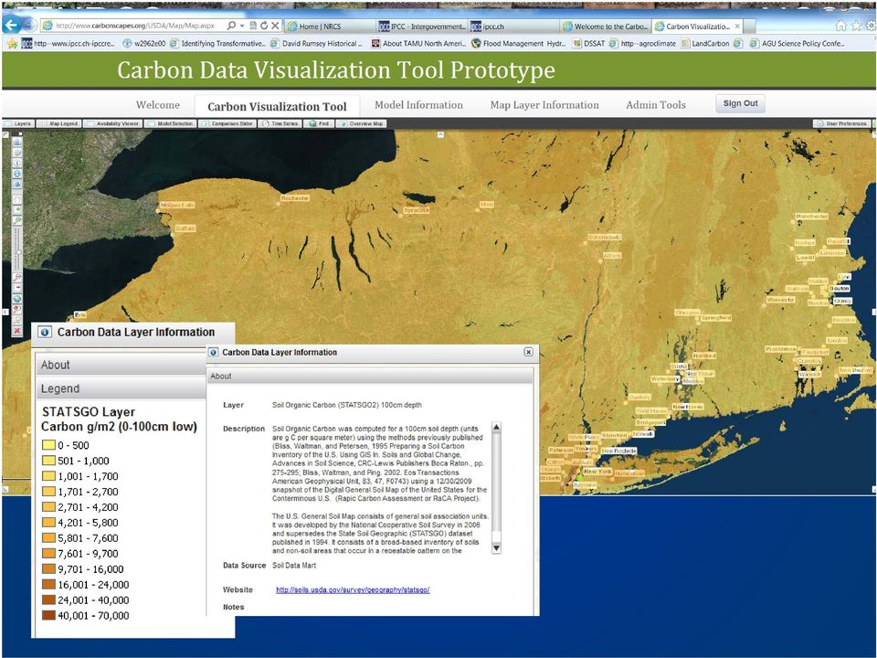
7 Existing Carbon Data Visualization Tool (CDVT) Functions ArcGIS Web Tool (pan, zoom, overlay, report, swipe tool) Uses SQL Server DB Large collection of USDA Carbon Inventory data Crop Data Layers and Change Detection Gridded SSURGO Carbon Stocks/STATSGO2 Carbon stocks PRISM FIA and Forest Cover USDA Models and some run results USFS Models (COLE, ForCarb, CCT, et. NRCS Models (DayCent, COMET-VR, etc.) ARS Models (CQUESTOR)

8 8

9
10

11

12
13 Critigen Carbon Data Visualization Tool (CDVT) Deficiencies Too complex Not easy to use Need GIS skills to decipher interface No simple reporting tool No data download capability Decision Seek University Cooperator to provide desired User Interface Enhancements to CDVT WVU CESU ( )

14 New USDA CarbonScapes Players West Virginia GIS Technical Center Kurt Donaldson, Director West Virginia University Department of Geology and Geography (Eberly College of Arts and Sciences) Staff and Graduate Students Division of Plant and Soil Sciences (Davis College of Agriculture) Dr. James Thompson, Professor of Pedology
")
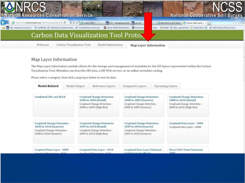
15 New USDA CarbonScapes Tasks Completed Ported Critigen CDVT to WVU computing resources 2. Established url for project development 3. Conducted focus group and user requirements gathering surveys 4. Preparing reporting and clearing house tools based on focus group and survey findings

16 Focus groups included representatives suggested by the former CDVT USDA Team members. Very thoughtful and helpful group (USDA and partners) Key findings: - Carbon stock and mass units matter! - Everyone want to take the data with them or add to local GIS project - Everyone prefers different summary regions (States, counties, MLRA, Ecoregions, basins) - Everyone prefers their own model - Most don t stray far from their own terrestrial carbon cycle pool 16
 - Everyone prefers their own model - Most don t stray far")
17 Selected survey results 17

18 18

19 19

20 20

21 USDA CarbonScapes Tools Three Tools Proposed: 1. Advanced Data Viewer (enhanced CDVT) 2. Public Summary Site 3. Clearinghouse
22 Old New USDA CarbonScapes Table 1. Proposed CarbonsScapes Tools CarbonScapes Survey Results: 85K76L68/ Advanced Data Viewer (Critigen Application) User s Manual: New Data Sources Web Services Reporting Data Download Metadata Search
23 USDA CarbonScapes Tools 1. Advanced Data Viewer (re-worked CDVT) For users seeking a richer, interactive experience with the data can turn to the existing online toolset accessed at (think GIS geek...) CDVT augmented with a more robust set of help and informational items including a series of video, audio, or graphical/textual tutorials to help users understand how to effectively use the existing toolset. Hidden links to the clearinghouse allow users to quickly and easily consume the raw data if desired.
24 USDA CarbonScapes Tools 2. Public Summary Site Curated (user directed) online mapping system that synthesizes (reports) big data into a more complete understanding of the national or regional picture. Provides a 10,000 foot view of the data for users of all levels of online technical expertise Answers questions such as How much soil carbon is there in the upper meter for MLRA 136? by providing a downloadable map and table
25 USDA CarbonScapes Tools 3. Clearinghouse Users will be able to search and browse for datasets which exist, find the minimal descriptions of the data, view fuller FGDC style metadata if it exists for a particular dataset, and find a way to download or otherwise consume the data. The user interface is expected to be easily understandable by anyone reasonably familiar with the Internet. and connections
26 26
27 27
28 28
29 29
30 30
31 31
32 USDA CarbonScapes: Mapping US Terrestrial Carbon Pools How can USDA Use CarbonScapes? 4. USDA Detailed Soils Example (could be used for any/all appropriate USDA map layers and model results) gssurgo VALU Table SOC calculations 0-100cm depth for Land Resource Region R Northeastern Forest and Forage Region. 32
33 Useful References gssurgo web site gssurgo Data Availability & Content 33
34 34
35 Content gssurgo VALU Table Database = Standard layers and zones 35
36 SOC g C / sq m, AWS mm gssurgo VALU Table Database Six standard layers 0 to 5 cm 5 to 20 cm 20 to 50 cm 50 to 100 cm 100 to 150 cm 150+ cm Five standard zones 0-5cm (same as layer 1) 0-20cm 0-30cm (full reported soil depth) cm 5-20 cm 20-50cm cm cm 150+ cm Image: Alfred Hartemink 36
37 SOC g C / sq m, AWS mm gssurgo VALU Table Database Six standard layers 0 to 5 cm 5 to 20 cm 20 to 50 cm 50 to 100 cm 100 to 150 cm 150+ cm Five standard zones 0-5cm (same as layer 1) 0-20cm 0-30cm (full reported soil depth) cm 5-20 cm 20-50cm cm cm 150+ cm Image: Alfred Hartemink 37
38 SOC g C / sq m, AWS mm gssurgo VALU Table Database Six standard layers 0 to 5 cm 5 to 20 cm 20 to 50 cm 50 to 100 cm 100 to 150 cm 150+ cm Five standard zones 0-5cm (same as layer 1) 0-20cm 0-30cm (full reported soil depth) cm 5-20 cm 20-50cm cm cm 150+ cm Image: Alfred Hartemink 38
39 SOC g C / sq m, AWS mm gssurgo VALU Table Database Six standard layers 0 to 5 cm 5 to 20 cm 20 to 50 cm 50 to 100 cm 100 to 150 cm 150+ cm Five standard zones 0-5cm (same as layer 1) 0-20cm 0-30cm (full reported soil depth) cm 5-20 cm 20-50cm cm cm 150+ cm Image: Alfred Hartemink 39
40 SOC g C / sq m, AWS mm gssurgo VALU Table Database Six standard layers 0 to 5 cm 5 to 20 cm 20 to 50 cm 50 to 100 cm 100 to 150 cm 150+ cm Five standard zones 0-5cm (same as layer 1) 0-20cm 0-30cm (full reported soil depth) cm 5-20 cm 20-50cm cm cm 150+ cm Image: Alfred Hartemink 40
41 SOC g C / sq m, AWS mm gssurgo VALU Table Database Six standard layers 0 to 5 cm 5 to 20 cm 20 to 50 cm 50 to 100 cm 100 to 150 cm 150+ cm Five standard zones 0-5cm (same as layer 1) 0-20cm 0-30cm (full reported soil depth) cm 5-20 cm 20-50cm cm cm 150+ cm Image: Alfred Hartemink 41
42 SOC g C / sq m, AWS mm gssurgo VALU Table Database Six standard layers 0 to 5 cm 5 to 20 cm 20 to 50 cm 50 to 100 cm 100 to 150 cm 150+ cm Five standard zones 0-5cm (same as layer 1) 0-20cm 0-30cm (full reported soil depth) cm 5-20 cm 20-50cm cm cm 150+ cm Image: Alfred Hartemink 42
43 SOC g C / sq m, AWS mm gssurgo VALU Table Database Six standard layers 0 to 5 cm 5 to 20 cm 20 to 50 cm 50 to 100 cm 100 to 150 cm 150+ cm Five standard zones 0-5cm (same as layer 1) 0-20cm 0-30cm (full reported soil depth) cm 5-20 cm 20-50cm cm cm 150+ cm Image: Alfred Hartemink 43
44 SOC g C / sq m, AWS mm gssurgo VALU Table Database Six standard layers 0 to 5 cm 5 to 20 cm 20 to 50 cm 50 to 100 cm 100 to 150 cm 150+ cm Five standard zones 0-5cm (same as layer 1) 0-20cm 0-30cm (full reported soil depth) cm 5-20 cm 20-50cm cm cm 150+ cm Image: Alfred Hartemink 44
45 SOC g C / sq m, AWS mm gssurgo VALU Table Database Six standard layers 0 to 5 cm 5 to 20 cm 20 to 50 cm 50 to 100 cm 100 to 150 cm 150+ cm Five standard zones 0-5cm (same as layer 1) 0-20cm 0-30cm (full reported soil depth) cm 5-20 cm 30 cm 20-50cm cm cm 150+ cm Image: Alfred Hartemink 45
46 SOC g C / sq m, AWS mm gssurgo VALU Table Database Six standard layers 0 to 5 cm 5 to 20 cm 20 to 50 cm 50 to 100 cm 100 to 150 cm 150+ cm Five standard zones 0-5cm (same as layer 1) 0-20cm 0-30cm 0-100** our example (full reported soil depth) cm 5-20 cm 20-50cm cm cm 150+ cm Image: Alfred Hartemink 46
47 SOC g C / sq m, AWS mm gssurgo VALU Table Database Six standard layers 0 to 5 cm 5 to 20 cm 20 to 50 cm 50 to 100 cm 100 to 150 cm 150+ cm Five standard zones 0-5cm (same as layer 1) 0-20cm 0-30cm (full reported soil depth) cm 5-20 cm 20-50cm cm cm 150+ cm Image: Alfred Hartemink 47
48 48
49 49
50 Summary by State/County 50
51 Summary by watershed/basins (12-digit HUC) 51
52 USDA CarbonScapes: Mapping US Terrestrial Carbon Pools Involve Global Change Task Force to: 1. Identify authoritative USDA carbon data sources 1. Carbon Models and results 2. Geospatial layers and associated attributes (web services where available) 3. Proper use of USDA design principles (user interfaces, public affairs Existing reference web application sites, etc.) 2. Raise awareness about USDA CarbonScapes Potential 1. Build on OMB FGDC Geoplatform principles 2. Pubic access to USDA Carbon Data/Models via 3. Geospatial (big data) Planning and Reporting of GHG Inventories 3. Identify Sponsor to raise project above Agency Level (NRCS) for USDA OCIO consideration no easy way to develop multiagency collaborative tools with National focus, presently (hampers our science) 52
53 USDA CarbonScapes Web Sites USDA CarbonScapes Development site CarbonScapes Survey Results: Advanced Data Viewer (Critigen Application) User s Manual: 53
54 Questions? USDA-NRCS National Soil Survey Center January 2015 Sharon Waltman Soil Scientist Geospatial Research Unit
USDA Carbon Data Visualization Tool Software Users Manual
 USDA Carbon Data Visualization Tool Software Users Manual Version 1.0 April 2012 Critigen and The catalyst to modernize critical infrastructure are trademarks of Critigen. All other trademarks used herein
SECTION 1. INTRODUCTION...
 USDA Carbon Data Visualization Tool Configuration Manual Administration Guide Version 1.0 August 2012 Critigen and The catalyst to modernize critical infrastructure are trademarks of Critigen. All other
CIESIN Columbia University
 Conference on Climate Change and Official Statistics Oslo, Norway, 14-16 April 2008 The Role of Spatial Data Infrastructure in Integrating Climate Change Information with a Focus on Monitoring Observed
Appendix: National Value Added Look Up (valu) Table Database for gsurrgo Soil Data
 Table Database for gsurrgo Soil Data") Appendix: National Value Added Look Up (valu) Table Database for gsurrgo Soil Data 1 VALU Table Theme VALU Table Column Name _ short VALU Table Column Name _ long VALU Table Column Name Short Description
Appendix: National Value Added Look Up (valu) Table Database for gsurrgo Soil Data 1 VALU Table Theme VALU Table Column Name _ short VALU Table Column Name _ long VALU Table Column Name Short Description
Geospatial Platform Support Contract Monthly Update to Coordination Group. James Irvine, PMO Contract Support FGDC OS June 7, 2016
 Geospatial Platform Support Contract Monthly Update to Coordination Group James Irvine, PMO Contract Support FGDC OS June 7, 2016 Topics Task Order Summaries Shared Infrastructure and Services GeoPlatform.gov
Nevada NSF EPSCoR Track 1 Data Management Plan
 Nevada NSF EPSCoR Track 1 Data Management Plan August 1, 2011 INTRODUCTION Our data management plan is driven by the overall project goals and aims to ensure that the following are achieved: Assure that
NRI Soil Monitoring Network
 NRI Soil Monitoring Network Stephen Ogle, Keith Paustian, Karolien Denef, Ram Gurung, F. Jay Breidt Colorado State University Mike Sucik and Daryl Lund USDA Natural Resources Conservation Service Goals
Mapping Application for Resource Planning
 Mapping Application for Resource Planning Wyoming Association of Conservation Districts Cathy Rosenthal, WACD Nephi Cole, NRCS SuiteWater Concept Create an Internet application to support WACD Natural
Andrea Buffam, Natural Resources Canada Canadian Metadata Forum National Library of Canada Ottawa, Ontario September 19 20, 2003
 Geospatial Metadata Andrea Buffam, Natural Resources Canada Canadian Metadata Forum National Library of Canada Ottawa, Ontario September 19 20, 2003 The Presentation - Geospatial Metadata This presentation
Australia s National Carbon Accounting System. Dr Gary Richards Director and Principal Scientist
 Australia s National Carbon Accounting System Dr Gary Richards Director and Principal Scientist Government Commitment The Australian Government has committed to a 10 year, 3 phase, ~$35M program for a
APFO Data Provisioning and Services
 Who We Are APFO is the primary source of aerial imagery for the U.S. Department of Agriculture. Data Stewards for NAIP, and historical aerial photography collected for USDA dating back to 1955. Who We
Guidelines on Information Deliverables for Research Projects in Grand Canyon National Park
 INTRODUCTION Science is playing an increasing role in guiding National Park Service (NPS) management activities. The NPS is charged with protecting and maintaining data and associated information that
Web-based GIS Application of the WEPP Model
 Web-based GIS Application of the WEPP Model Dennis C. Flanagan Research Agricultural Engineer USDA - Agricultural Research Service National Soil Erosion Research Laboratory West Lafayette, Indiana, USA
Soil Data Viewer 5.1 User Guide
 Soil Data Viewer 5.1 User Guide Soil Survey Division October 2006 INTRODUCTION... 5 WHAT IS SOIL DATA VIEWER... 5 WHAT SOFTWARE AND CAPABILITIES DO I NEED TO USE SOIL DATA VIEWER 5.1?... 5 WHAT DATA DO
Natural Resource-Based Planning*
 Natural Resource-Based Planning* Planning, when done well, is among the most powerful tools available to communities. A solid plan, based on good natural resource information, guides rational land-use
EEOS 381 - Spatial Databases and GIS Applications
 EEOS 381 - Spatial Databases and GIS Applications Lecture 9 Metadata What is Metadata? Data about data Description of a (GIS) dataset What it represents Who created it? When? How? Format Field definitions
Since early 1994, The Northern Sacramento Valley Sustainable Landscapes
 Using Population Distribution Forecasts and GIS Technology to Assess Potential Hardwood Loss in the Northern Sacramento Valley 1 Charles W. Nelson 2 Mark Radabaugh 3 Abstract: Since its inception, The
GIS Data Models for INSPIRE and ELF
 GIS Data Models for INSPIRE and ELF Paul Hardy Roberto Lucchi EuroSDR/ELF Copenhagen Data Modelling and Model Driven Implementation of Data Distribution 28 Jan 2015 ArcGIS for INSPIRE Extends ArcGIS for
A Web Service based U.S. Cropland Visualization, Dissemination and Querying System
 A Web Service based U.S. Cropland Visualization, Dissemination and Querying System Rick Mueller, Zhengwei Yang, and Dave Johnson USDA/National Agricultural Statistics Service Weiguo Han and Liping Di GMU/Center
Exploring GIS Integration Options for SAP BusinessObjects
 Exploring GIS Integration Options for SAP BusinessObjects Introduction In conversations with various individuals and businesses over the years, I hear a common question being raised: How do I integrate
Storytelling with Maps: Workflows and Best Practices
 Storytelling with Maps: Workflows and Best Practices Introduction What is a story map? Story maps are interactive maps combined with text and other content to tell a story about the world. Typically story
Appendix J Online Questionnaire
 Appendix J Online Questionnaire In accordance with the Paperwork Reduction Act, this questionnaire was approved by the Office of Management and Budget (OMB). The OMB control number and expiration date
WHAT IS GIS - AN INRODUCTION
 WHAT IS GIS - AN INRODUCTION GIS DEFINITION GIS is an acronym for: Geographic Information Systems Geographic This term is used because GIS tend to deal primarily with geographic or spatial features. Information
Expert Review and Questionnaire (PART I)
") NASA ARC Project 1-9-2001 Web-based Geospatial Information Services and Analytic Tools for Habitat Conservation and Management Expert Review and Questionnaire (PART I) Thank you for participating in this
NASA ARC Project 1-9-2001 Web-based Geospatial Information Services and Analytic Tools for Habitat Conservation and Management Expert Review and Questionnaire (PART I) Thank you for participating in this
http://www.esri.com/bia
 ArcGIS for Tribal Transportation Management David Gadsden Federal Account Manager dgadsden@esri.com d d 1 David Gadsden GIS Background UW Geography (1995) Peace Corps Tanzania Environmental Social Science
GIS Tools for Land Managers
 Citation: Karl, J. 2010. GIS Tools for Land Managers. Sound Science White Paper Series #05. www.sound-science.org. GIS Tools for Land Managers Most land managers recognize that geographic information systems
http://bco-dmo.org Go to: http://usjgofs.whoi.edu/jg/dir/jgofs/ URL: http://usjgofs.whoi.edu/jg/serv/jgofs/arabian/inventory.html0
 http://bco-dmo.org DATA ACCESS TUTORIAL 2012 OCB PI Summer Workshop Data access: catalog browse scenario 1: you are a former US JGOFS or US GLOBEC researcher, and you know what data you are looking for
GEOGRAPHIC INFORMATION GATEWAY New York Department of State (NYDOS) data acceptance & metadata standards
 data acceptance & metadata standards") GEOGRAPHIC INFORMATION GATEWAY New York Department of State (NYDOS) data acceptance & metadata standards 1. DATA ACCEPTANCE STANDARDS The following describes the data acceptance standards for data included
GEOGRAPHIC INFORMATION GATEWAY New York Department of State (NYDOS) data acceptance & metadata standards 1. DATA ACCEPTANCE STANDARDS The following describes the data acceptance standards for data included
Project Title: Project PI(s) (who is doing the work; contact Project Coordinator (contact information): information):
 (who is doing the work; contact Project Coordinator (contact information): information):") Project Title: Great Northern Landscape Conservation Cooperative Geospatial Data Portal Extension: Implementing a GNLCC Spatial Toolkit and Phenology Server Project PI(s) (who is doing the work; contact
Project Title: Great Northern Landscape Conservation Cooperative Geospatial Data Portal Extension: Implementing a GNLCC Spatial Toolkit and Phenology Server Project PI(s) (who is doing the work; contact
Modern Agricultural Digital Management Network Information System of Heilongjiang Reclamation Area Farm
 Modern Agricultural Digital Management Network Information System of Heilongjiang Reclamation Area Farm Xi Wang, Chun Wang, Wei Dong Zhuang, and Hui Yang Engineering Collage, Heilongjiang August the First
ArcGIS. Server. A Complete and Integrated Server GIS
 ArcGIS Server A Complete and Integrated Server GIS ArcGIS Server A Complete and Integrated Server GIS ArcGIS Server enables you to distribute maps, models, and tools to others within your organization
NATIONAL CLIMATE CHANGE & WILDLIFE SCIENCE CENTER & CLIMATE SCIENCE CENTERS DATA MANAGEMENT PLAN GUIDANCE
 NATIONAL CLIMATE CHANGE & WILDLIFE SCIENCE CENTER & CLIMATE SCIENCE CENTERS DATA MANAGEMENT PLAN GUIDANCE Prepared by: NCCWSC/CSC Data Management Working Group US Geological Survey February 26, 2013 Version
State of North Dakota. GIS Program Strategic Plan 2015-2017
 State of North Dakota GIS Program Strategic Plan 2015-2017 Prepared By: Bob Nutsch GIS Coordinator Information Technology Department Approved By: North Dakota GIS Technical Committee Date of Publication:
Development of an Impervious-Surface Database for the Little Blackwater River Watershed, Dorchester County, Maryland
 Development of an Impervious-Surface Database for the Little Blackwater River Watershed, Dorchester County, Maryland By Lesley E. Milheim, John W. Jones, and Roger A. Barlow Open-File Report 2007 1308
A Data Library Management System for Midwest FreightView and its Data Repository
 A Data Library Management System for Midwest FreightView and its Data Repository Final Report By Peter Lindquist, Ph.D. Associate Professor Department of Geography and Planning The University of Toledo
1. Abstract. 2. The Problem / Need for the Program
 Program Information: Montgomery County, Maryland Program Title: A GIS Platform for Emergency Management and Response: Common Operational Pictures (COP) Program Category: # 14, Information Technology 1.
Web Based GIS Consulting Portal with Crop-Land Suitability
 Web Based GIS Consulting Portal with Crop-Land Suitability P.K.S.C. Jayasinghe a, Takemi Machida b a Ibaraki University, Ibaraki prefecture, Japan, subashjp@yahoo.com, b Ibaraki University, Ibaraki prefecture,
Monitoring Global Crop Condition Indicators Using a Web-Based Visualization Tool
 Monitoring Global Crop Condition Indicators Using a Web-Based Visualization Tool Bob Tetrault, Regional Commodity Analyst, and Bob Baldwin, GIS Specialist, USDA, Foreign Agricultural Service, Washington,
New Media Roles, Responsibilities, and Authorities Approved by: Associate Administrator for Operations and Management
 UNITED STATES DEPARTMENT OF AGRICULTURE Farm Service Agency Washington, DC 20250 Notice INFO-54 For: FSA Employees New Media Roles, Responsibilities, and Authorities Approved by: Associate Administrator
Harvard Data Visualization Project
 Esri User Conference, July 12-15, San Diego California Harvard Data Visualization Project Spatio-Temporal Visualization of Global Phenomena: 1850 to the Present Harvard Business School Geoffrey Jones Walter
Weed Survey and Mapping
 Weed Survey and Mapping The primary objective of weed surveying and mapping is to accurately identify and delineate land with populations of invasive plants or noxious weeds. These surveys allow land managers
Amazon Hosted ESRI GeoPortal Server. GeoCloud Project Report
 Amazon Hosted ESRI GeoPortal Server GeoCloud Project Report Description of Application Operating Organization The USDA participated in the FY 2011 Federal Geographic Data Committee (FGDC) GeoCloud Sandbox
Downloading SSURGO Soil Data from Internet
 Downloading SSURGO Soil Data from Internet Prepared by Venkatesh Merwade School of Civil Engineering, Purdue University vmerwade@purdue.edu September 2012 Purpose The purpose of this exercise to demonstrate
Open Data. Open Data. Share and map your data with ArcGIS. technology.
 Open Data Share and map your data with ArcGIS Open Data technology. Publishing data as map services is one of the most valuable ways to communicate and collaborate. Maps enable an immediate understanding
DEVELOPMENT OF WEB-BASED GIS INTERFACES FOR APPLICATION OF THE WEPP MODEL
 DEVELOPMENT OF WEB-BASED GIS INTERFACES FOR APPLICATION OF THE WEPP MODEL D.C. Flanagan A, J.R. Frankenberger A, C.S. Renschler B and B.A. Engel C A National Soil Erosion Research Laboratory, USDA-ARS,
Cookbook 23 September 2013 GIS Analysis Part 1 - A GIS is NOT a Map!
 Cookbook 23 September 2013 GIS Analysis Part 1 - A GIS is NOT a Map! Overview 1. A GIS is NOT a Map! 2. How does a GIS handle its data? Data Formats! GARP 0344 (Fall 2013) Page 1 Dr. Carsten Braun 1) A
Tutorial 6 GPS/Point Shapefile Creation
 Tutorial 6 GPS/Point Shapefile Creation The objectives of this tutorial include: 1. Converting GPS field collected point information into a shapefile 2. Creating a shapefile from a simple x,y coordinate
EXTENSION ACTIVITY SUPPORT SYSTEM (EASY) DEMONSTRATOR USE CASES
 DEMONSTRATOR USE CASES") EXTENSION ACTIVITY SUPPORT SYSTEM (EASY) DEMONSTRATOR USE CASES Use Case Specification Developed for DPI Victoria and Cooperative Research Centre for Spatial Information (CRC SI) Prepared by Innovations
EXTENSION ACTIVITY SUPPORT SYSTEM (EASY) DEMONSTRATOR USE CASES Use Case Specification Developed for DPI Victoria and Cooperative Research Centre for Spatial Information (CRC SI) Prepared by Innovations
ADWR GIS Metadata Policy
 ADWR GIS Metadata Policy 1 PURPOSE OF POLICY.. 3 INTRODUCTION.... 4 What is metadata?... 4 Why is it important? 4 When to fill metadata...4 STANDARDS. 5 FGDC content standards for geospatial metadata...5
Virginia Commonwealth University Rice Rivers Center Data Management Plan
 Virginia Commonwealth University Rice Rivers Center Data Management Plan Table of Contents Objectives... 2 VCU Rice Rivers Center Research Protocol... 2 VCU Rice Rivers Center Data Management Plan... 3
Free Google Tools for Creating Interactive Mapping Mashups
 Free Google Tools for Creating Interactive Mapping Mashups Cary Chadwick Emily Wilson Tuesday, May 10, 2011 2pm Welcome to the CLEAR Webinar Series! This is the fourth in the 2011 series Riparian Corridors,
Standard 5: Use a consistent data management framework in accordance with internal and partner organization data standards.
 Standard 5: Use a consistent data management framework in accordance with internal and partner organization data standards. [conceptualize]1 Rationale Establishing and using a consistent data management
Oklahoma Geographic Information Council
 Oklahoma State University Agriculture Cooperative Extension Service Presentation To: Oklahoma Geographic Information Council For McCurtain County GIS Pilot Project Project Overview & Project Results Proposed
The Big Data Integration and Analytics Revolution in Agricultural Finance, Risk, and Insurance
 The Big Data Integration and Analytics Revolution in Agricultural Finance, Risk, and Insurance Joshua D. Woodard Assistant Professor and Zaitz Faculty Fellow in Agribusiness and Finance Dyson School of
Quick Start Guide to. ArcGISSM. Online. for Public Accounts
 Quick Start Guide to ArcGISSM Online for Public Accounts Using ArcGIS Online with a Public Account ArcGIS SM Online is a cloud-based mapping platform that allows you to easily and quickly make maps, collaborate,
What is GIS? Why Geography?
 Geographic Information System (GIS), What is GIS? contributed by the Spatial Data Management Division, secretariat of the Land Information Council of Jamaica (LICJ), Ministry of Agriculture. Contact Ms.
There are various ways to find data using the Hennepin County GIS Open Data site:
 Finding Data There are various ways to find data using the Hennepin County GIS Open Data site: Type in a subject or keyword in the search bar at the top of the page and press the Enter key or click the
Design & Analysis Tools for Inventory & Monitoring: DATIM
 Design & Analysis Tools for Inventory & Monitoring: DATIM Background Monitoring is conducted at a variety of scales and for a variety of purposes. FS spends roughly half a billion/year on I&M Under the
Standards for the Preparation of Digital Geospatial Metadata
 National Mapping Program Technical Instructions Standards for the Preparation of Digital Geospatial Metadata U.S. Department of the Interior U.S. Geological Survey National Mapping Division PREFACE On
Subject: Using Google Earth, Google Earth Pro, and Google Maps for FWS activities
 Subject: Using Google Earth, Google Earth Pro, and Google Maps for FWS activities Page 1 of 5 As an FWS employee, can I use Google mapping software or applications to help me with my job? The short answer
Mapping Your Land: An Overview for Landowners
 Mapping Your Land: An Overview for Landowners Online Mapping and Spatial Resources for the Private Forest Landowner Tutorials by John C. Gilbert 1 and John S. Kush 1 Design and Layout by Elizabeth P. Bowersock
A Workflow for Creating and Sharing Maps
 A Workflow for Creating and Sharing Maps By Keith Mann, Esri What You Will Need Item Source ArcGIS Online for Organizations subscription ArcGIS 10.1 for Desktop (Any license level) ArcGIS Spatial Analyst
Appendix D Flood Damage Assessment
 Appendix D Flood Damage Assessment There is no single definition of the phrase flood-damage assessment that is applicable to all agencies. Such a definition would be difficult to develop and may be unnecessary.
Finding GIS Data and Preparing it for Use
 Finding_Data_Tutorial.Doc Page 1 of 19 Getting Ready for the Tutorial Sign Up for the GIS-L Listserv Finding GIS Data and Preparing it for Use The Yale University GIS-L Listserv is an internal University
ArcGIS online Introduction... 2. Module 1: How to create a basic map on ArcGIS online... 3. Creating a public account with ArcGIS online...
 Table of Contents ArcGIS online Introduction... 2 Module 1: How to create a basic map on ArcGIS online... 3 Creating a public account with ArcGIS online... 3 Opening a Map, Adding a Basemap and then Saving
REACCH PNA Data Management Plan
 REACCH PNA Data Management Plan Regional Approaches to Climate Change (REACCH) For Pacific Northwest Agriculture 875 Perimeter Drive MS 2339 Moscow, ID 83844-2339 http://www.reacchpna.org reacch@uidaho.edu
Implementing a Web-based Transportation Data Management System
 Presentation for the ITE District 6 Annual Meeting, June 2006, Honolulu 1 Implementing a Web-based Transportation Data Management System Tim Welch 1, Kristin Tufte 2, Ransford S. McCourt 3, Robert L. Bertini
Introducing Web-Based Decision Tools for Watershed Management. http://www.epa.gov/ waterspace/
 Introducing Web-Based Decision Tools for Watershed Management http://www.epa.gov/ waterspace/ Locally Led Watershed Management Bringing together scientific information Screening alternatives Writing, evaluating,
Latin American and Caribbean Flood and Drought Monitor Tutorial Last Updated: November 2014
 Latin American and Caribbean Flood and Drought Monitor Tutorial Last Updated: November 2014 Introduction: This tutorial examines the main features of the Latin American and Caribbean Flood and Drought
Wyoming Geographic Information Science Center University Planning 3 Unit Plan, 2009-2014 #
 I. Mission and Aspirations Wyoming Geographic Information Science Center University Planning 3 Unit Plan, 2009-2014 # The mission of the Wyoming Geographic Information Science Center (WyGISC) is to advance
ASHLEY MURPHY JOHNSON. 6351 Christopher Creek Road West, Jacksonville, Fl 32217 (904) 514-2583 ajohnso40@ju.edu
 514-2583 ajohnso40@ju.edu") ASHLEY MURPHY JOHNSON 6351 Christopher Creek Road West, Jacksonville, Fl 32217 (904) 514-2583 ajohnso40@ju.edu EDUCATION Ph.D. in Interdisciplinary Ecology August 2004 Dissertation: Estuary Use Planning
ASHLEY MURPHY JOHNSON 6351 Christopher Creek Road West, Jacksonville, Fl 32217 (904) 514-2583 ajohnso40@ju.edu EDUCATION Ph.D. in Interdisciplinary Ecology August 2004 Dissertation: Estuary Use Planning
ArcGIS Agricultural Land Use Maps from the Mississippi Cropland Data Layer
 ArcGIS Agricultural Land Use Maps from the Mississippi Cropland Data Layer Fred L. Shore, Ph.D. Mississippi Department of Agriculture and Commerce Jackson, MS, USA fred_shore@nass.usda.gov Rick Mueller
Range Management Databases on the Web: Two Examples
 Range Management Databases on the Web: Two Examples George Ruyle, Chair, Rangeland & Forest Research Program, School of Renewable Natural Resources, Biological Sciences East 302, University of Arizona,
Quick Start Guide to. ArcGISSM. Online. for Insurance
 Quick Start Guide to ArcGISSM Online for Insurance Historic tracks from tropical storms and hurricanes are overlaid on a map displaying population growth. Quick Start Guide to ArcGIS Online ArcGIS SM Online
Homeland Security Infrastructure Program HSIP Gold 2012 September 2012
 Homeland Security Infrastructure Program HSIP Gold 2012 September 2012 George Thomas, Chief, Content & Knowledge Management Division (PDC) IWG-Readiness, Response & Recovery (IWG-R3) George.J.Thomass@nga.mil,
How To Use The Alabama Data Portal
 113 The Alabama Metadata Portal: http://portal.gsa.state.al.us By Philip T. Patterson Geological Survey of Alabama 420 Hackberry Lane P.O. Box 869999 Tuscaloosa, AL 35468-6999 Telephone: (205) 247-3611
Introduction to GIS software
 Introduction to GIS software There are a wide variety of GIS software packages available. Some of these software packages are freely available for you to download and could be used in your classroom. ArcGIS
CHAPTER I: INTRODUCTION. Background
 CHAPTER I: INTRODUCTION Background California State Law requires each county to adopt a General Plan for the physical development of the county and any land outside its boundaries which bears relation
desert conservation program Data Management Guidelines
 desert conservation program Data Management Guidelines Introduction The Multiple Species Habitat Conservation Plan (MSHCP) and the U.S. Fish and Wildlife Service Biological and Conference Opinion on Clark
Geospatial Segment Architecture and GeoCloud Update. Doug Nebert FGDC Architecture and Technology WG
 Geospatial Segment Architecture and GeoCloud Update Doug Nebert FGDC Architecture and Technology WG Background FEA Geospatial Profile was developed for the LoB process to inform agency architectures on
WLIA Standard. Content Standard for Geospatial Metadata
 WLIA Standard Content Standard for Geospatial Metadata Version: September 2000 WLIA Standard 2000-8 Wisconsin Land Information Association Frontispiece The Wisconsin Land Information Association Board
Bhuvan. Indian Earth Observation Visualization. Indian Space Research Organisation. http://bhuvan.nrsc.gov.in. Multi Resolution. Societal Applications
 Multi Resolution Bhuvan Societal Applications Indian Earth Observation Visualization http://bhuvan.nrsc.gov.in 3D Geographic Models Seamless Fly Through Indian Space Research Organisation Thematic Vectors
Improving global data on forest area & change Global Forest Remote Sensing Survey
 Improving global data on forest area & change Global Forest Remote Sensing Survey work by FAO and partners - Adam Gerrand, E. Lindquist, R. D Annunzio, M. Wilkie, FAO, - F. Achard et al. TREES team at
Web Editing Tutorial. Copyright 1995-2010 Esri All rights reserved.
 Copyright 1995-2010 Esri All rights reserved. Table of Contents Tutorial: Creating a Web editing application........................ 3 Copyright 1995-2010 Esri. All rights reserved. 2 Tutorial: Creating
Ag-Analytics Documentation
 Ag-Analytics Documentation Release 1.0 Joshua Woodard, Lin Xue February 11, 2016 Contents 1 1. What is Ag-Analytics? 3 2 2. Finding Data 5 2.1 2.1. Data Overview............................................
Texas Develops Online Geospatial Data Repository to Support Emergency Management
 Bing Maps for Enterprise Microsoft Customer Solution Case Study Texas Develops Online Geospatial Data Repository to Support Emergency Management Overview Country or Region: United States Industry: Government
CRMS Website Training
 CRMS Website Training March 2013 http://www.lacoast.gov/crms Coastwide Reference Monitoring System - Wetlands CWPPRA Restoration Projects Congressionally funded in 1990 Multiple restoration techniques
Best practice use of GI within utility companies From Desktop to the Field
 Best practice use of GI within utility companies From Desktop to the Field Agenda IMGS Introduction Historical Use of GI in utilities New Utility Trends GI - Moving off the island into the enterprise Integrated
Primavera Project Management System at WVDOT. Presented by Marshall Burgess, WVDOT Stephen Cole, Stephen Cole Consulting Jervetta Bruce, CDP, Inc.
 : Integrating GIS With Primavera Project Management System at WVDOT Presented by Marshall Burgess, WVDOT Stephen Cole, Stephen Cole Consulting Jervetta Bruce, CDP, Inc. WVDOT Geographic Information System
Integrated Information Management System, Development of Web Interface, a.k.a. Online Data Portal (ODP)
") Integrated Information Management System, Development of Web Interface, a.k.a. Online Data Portal (ODP) USBR Science and Technology Project ID 3625 Eric Peterson, May 2014. Duration: Fiscal Year 2010 through
Integrated Information Management System, Development of Web Interface, a.k.a. Online Data Portal (ODP) USBR Science and Technology Project ID 3625 Eric Peterson, May 2014. Duration: Fiscal Year 2010 through
Learning about GPS and GIS
 Learning about GPS and GIS Standards 4.4 Understand geographic information systems (G.I.S.). B12.1 Understand common surveying techniques used in agriculture (e.g., leveling, land measurement, building
Description of Simandou Archaeological Potential Model. 13A.1 Overview
 13A Description of Simandou Archaeological Potential Model 13A.1 Overview The most accurate and reliable way of establishing archaeological baseline conditions in an area is by conventional methods of
A. Title of Proposed Project Development of a Protected Areas Database for Jamaica
 A. Title of Proposed Project Development of a Protected Areas Database for Jamaica B. Contact Information for Project Manager(s) Name: Sheries Simpson Address:10 Caledonia Avenue, Kingston 5. Country:
Mississippi Private Schools 2015
 Mississippi Private Schools 2015 Shapefile Tags education, schools, private, K-12 Summary To add to state data clearinghouse the Mississippi private schools point features. Description Point locations
ArcGIS Reference Document
 Migration of GIS Data to ArcSDE Page 1 of 10 Table of Contents A Brief Summary of DEP s GIS Data Storage o The Y Drive o ArcSDE (Spatial Database) Keeping Your GIS Project Data Current o Checking Your
Creating a File Geodatabase
 Creating a File Geodatabase Updated by Thomas Stieve January 06, 2012 This exercise demonstrates how to create a file geodatabase in ArcGIS 10; how to import existing data into the geodatabase, and how
Michigan Tech Research Institute Wetland Mitigation Site Suitability Tool
 Michigan Tech Research Institute Wetland Mitigation Site Suitability Tool Michigan Tech Research Institute s (MTRI) Wetland Mitigation Site Suitability Tool (WMSST) integrates data layers for eight biophysical
Deploying Federal Geospatial Services
 Deploying Federal Geospatial Services in the Cloud: Federal Geographic Data Committee (FGDC) and GSA GeoCloud Sandbox Initiative Doug Nebert USGS/FGDC December 2010 Draft For Official Use Only 1 Background
An Introduction to Data Virtualization as a Tool for Application Development
 An Introduction to Data Virtualization as a Tool for Application Development Accur8 Software 73 Main St. Suite 7, Brattleboro, VT 05301 accur8software.com INTRODUCTION When a developer or team of developers
EXPLORING AND SHARING GEOSPATIAL INFORMATION THROUGH MYGDI EXPLORER
 EXPLORING AND SHARING GEOSPATIAL INFORMATION THROUGH MYGDI EXPLORER Subashini Panchanathan Malaysian Centre For Geospatial Data Infrastructure ( MaCGDI ) Ministry of National Resources and Environment