Geography 4203 / GIS Modeling. Class 12: Spatial Data Quality and Uncertainty
|
|
|
- Ashlyn Singleton
- 7 years ago
- Views:
Transcription
1 Geography 4203 / 5203 GIS Modeling Class 12: Spatial Data Quality and Uncertainty

2 Some Updates - Progress Reports Progress reports: 11 & 14 April (instead of 14 & 16 April) Class on 16 April: Jeremy Class on 18 April: Babs comes for guest lecture One-to-One meetings with project leaders: 21 & 23 April (instead of 18 & 21 April) Final presentations : 23, 25, 28 & 30 April (as planned)
 Final presentations : 23, 25, 28 & 30 April (as")
3 Last Lecture We finished with the very last part of spatial estimation We had a look at sampling issues and core area methods You understand why core area delineation is so important in different fields for extraction, modeling and evaluation You realize how to implement the ideas of transforming lower-order objects into higher-order objects You can explain how Kernel methods, convex hull and mean center approaches work

4 Today s Outline Coming to aspects of spatial data quality Uncertainty and spatial data quality - why are they important See some examples of consequences of uncertainty in Spatial Data Learning more about the terminology used and what these terms mean How to describe quality of spatial data and why standards have been evolved for transfer standard

5 Learning Objectives Understanding of uncertainty and spatial data quality as well as some of the consequences Terms and terminology such as accuracy, error, precision, What the SDTS is and what stands behind the famous five points

6 Where to Start? Maybe by asking: What is quality? - Reaching the best result possible - Reaching the requirements defined by standards or customers - Reaching the requirements for a specific application -- Fitness for use In summary this seems to be about uncertainty, how it arises and propagates throughout the process the spatial data are applied to

7 Quality <> Uncertainty??? Uncertainty is considered to embrace the unknown domain how good our data are (too many types and subtypes to be listed here) However uncertainty influences our spatial data quality (question how this quality is specified) Uncertainty can be introduced at any stage of GISbased map production and analysis (Reality observation, conceptual modeling, measurement, analysis steps, and are we missing one here?)
 Uncertainty can be introduced at any stage of GISbased map production and analysis")
8 Any Differences? Remember our readings discussion about uncertainty and SDQ Both fields are dedicated to related issues but went into different directions with regard to research foci However we will explore the role of uncertainty and how it influences SDQ during this class set

9

10 Some examples Let s look at some examples how important uncertainty can be What are the potential (or real) consequences of decisions based on uncertain data sources? Keep in mind how SDQ can be specified

11 How reliable is catchment delineation from topographic maps? What could be the consequences of unreliability in these boundaries?? from

12 How reliable are estimations of land cover changes? Example Switzerland: During the last 100 years the forest cover increased by ca. 30%!!! Wow! But here s the truth: We don t know.

13 How reliable are estimations of land cover changes? Forest definitions in different time periods Drivers of forest mapping and political interests as well as conflicts (serious ones ) Practice of mapping in the 19th century What are the materials available to get evidence?

14 How to Approach & Apply Historical Spatial Data? if you want to use them for GIS based change analysis

15 Representing on-theground information How often is a value wrong (classified for categorical data)? Numbers (average error ) or error distributions How do we conceptualize features? What is the collection method? What do we misunderstand? How much up-to-date are the data?

16 So where Comes Uncertainty from? Limitation in the data (raster cell s resolution) Mixed categories and homogenuous value of a raster cell ( loosing small fractions ): inclusion/generalization Gradual changes within transition zones Collection, map production, processing Non-tracked changes in land cover/ vegetation

17 Just Using Certain Data? There is no perfect data We have to be aware of uncertainty associated with the data, the underlying meaning, the processing steps to be carried out and the planned application (fit for use?) For this reason it is so fundamental to know more about uncertainty and its influence to SDQ Find some direction within the term clouds, first! We ll start with uncertainty and come to SDQ then Time for some definitions
 For this reason it is so fundamental to know more about uncertainty and its influence to SDQ Find some")
18 Definitions -- Uncertainty doubt about the information which is recorded at a location (Fisher 2003) a measure of the difference between the data and the meaning attached to the data by the current user Zhang and Goodchild (2002) the result of error, ambiguity, vagueness or lack of information (Fisher 1999, Atkinson and Foody 2002) --> an umbrella term for these concepts
 --> an umbrella term for these")
19 Fisher 1999 Uncertainty
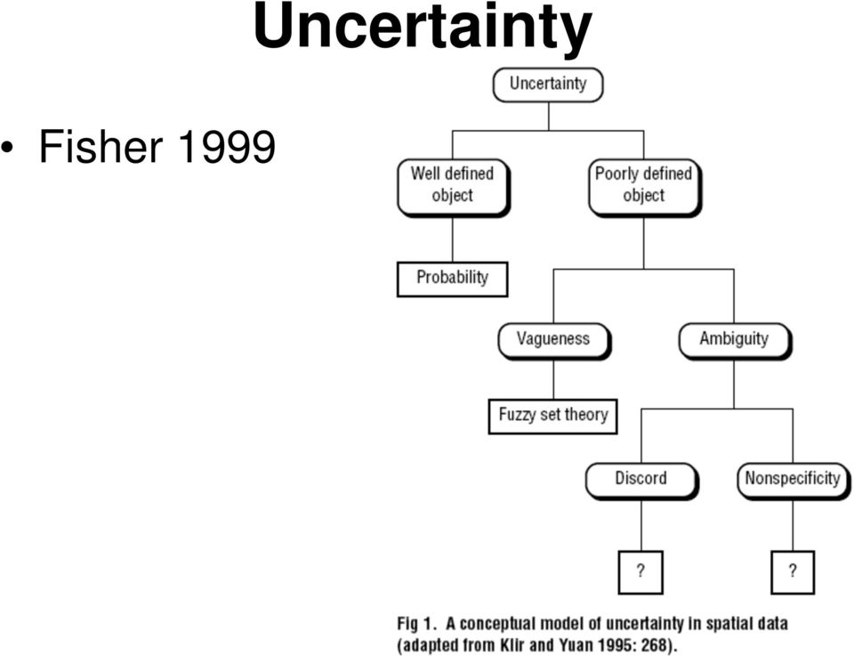
20 Definitions -- Uncertainty lack of knowledge about: (1) objects of the real world due to erroneous measurement, vague definitions and concepts or unknown and ambiguous meaning; (2) effects of transformations performed on the data; and (3) the latter s suitability for the intended application Do you recognize three aspects here?

21 Definitions -- Error Error: Difference between a computed, observed or measured value or condition and the true, specified or theoretically correct value or condition (Oxford Reference Online 1996) describes the deviation of a value from truth (Jones 1997) Inaccuracy in cases of systematic error and Imprecision in cases of random errors Describing cases of measurable deviation from the true state where no problems of definition occur.
22 Definitions -- Accuracy & Precision Accuracy: Difference between a recorded value and its true value (often divided into spatial, topological and attribute accuracy). In practice truth is a reference value, which is assumed to be more accurate Systematic error Precision: Detail with which a measurement is reported - there is no point reporting a measurement to a higher precision than that with which it is measured How repeatable is a process or measurement? Random error
23 Precision & Accuracy
24 Vagueness Indeterminacy due to a lack of distinctness between ill-defined or fuzzy classes of objects or individual objects. In GIS vagueness in definition causes doubt over the membership of a considered location to one class or several classes Sorites paradox (Williamson 1994) & degree of truth (a) property of objects, (b) purely linguistic, (c) epistemic in nature or (d) purely semantic
25 Vagueness from from from hioline.osu.edu/b915/part_one.html
26 (from Fisher et al., 2004)
27 Ambiguity Confusion among concepts which have the same name, but more than one definition (Fisher 2000) Discord: lack of agreement if one object is clearly defined but is shown to be a member of different classes under differing classification schemes or interpretations Non-specificity: Occurrence of ambiguity if the assignment of an object to a class is unsettled at all (it is then a matter of interpretation and prone to subjectivity)
28 from
29 A Bringing-Together Error is not due to problems of definition but due to measurable deviations from truth Vagueness arises due to overlapping definitions and is thus only considerable in the context of an environment with other objects or classes of objects Ambiguity is caused by definitions with different meaning under varying classification schemes (discord) or weak definitions (nonspecificity) without consideration of its environment
30 Reporting Data Quality Data are passed around and manipulated by many people, within and between organizations, intentionally and unintentionally By reporting on data quality and understanding these concepts, we can minimize uncertainty or choose more appropriate products Burrough and McDonnell list factors affecting data quality...
31 Where we started? by asking: What is quality? - Reaching the best result possible - Reaching the requirements defined by standards or customers - Reaching the requirements for a specific application -- Fitness for use In summary this seems to be about uncertainty, how it arises and propagates throughout the process the spatial data are applied to
32 SDTS Developed in the US to allow transfer of data between organizations using a defined and agreed standard Spatial Data Transfer Standard (SDTS 1992) is obligatory for US Federal Organisations to use the SDTS Included compulsory data quality fields (note these are only a small part of Burrough and McDonnell s list of factors affecting data quality)
33 The SDTS famous Five Positional accuracy: e.g. the accuracy with which the positions of depth soundings were reported Attribute accuracy: e.g. the accuracy of the actual depth soundings; the classification of a pixel which is bog as urban area Logical consistency: e.g. are values valid (is there a class called bag, are there topological problems (e.g. overlapping polygons with different classes) Completeness: e.g. Has a polygon not been digitized, what was the minimum size of object included, what was the density of observation? Lineage: Who produced the data, what methods did they use, why were the data produced, when?
34
35 The Famous Five??? Things change from SDTS (1992) to Guptill S C and C Morrison J L (eds) 1995 Elements of Spatial Data Quality. So, how to bring them (SDQ, Uncertainty types, Uncertainty domains, ) together now?
36 Remember Uncertainty is considered to embrace the unknown domain how good our data are However uncertainty influences our spatial data quality (is our data good enough in relation to standards?) Uncertainty can be introduced at any stage of GIS-based map production and analysis (Reality observation, conceptual modeling, measurement, analysis steps, and use of the data)
37 where Uncertainty Comes from The case of historical spatial data:
38 Metadata
39 Summary Uncertainty and Spatial Data Quality have much in common, they consider similar topics and have related categories or domains Uncertainty embraces the unknown domain to give the basis for judgments, how good the data are SDQ rather allows to ask if our data are good enough with regard to standards or expectations Uncertainty in Spatial information is still an open research environment due to the many unresolved questions existing New concepts and methods such as from fuzzy logic have been introduced into uncertainty research As you can expect, fitness for use and use error are a very important part for industrial developments of spatial data technology
40 References Burrough, P.A. and McDonnell, R.A. (1998):Principles of Geographical Information Systems. Second Edition. Oxford University Press. Jones, C.B. (1997): Geographical Information Systems and Computer Cartography. Longman. Longley et al Geographic Information Systems and Science. Wiley. Fisher P 1999 Models of uncertainty in spatial data. In Longley P, Goodchild M F, Maguire D J, and Rhind D W (eds) Geographical Information Systems: Principles, Techniques, Management and Applications (Volume 1). New York, John Wiley and Sons: Fisher P 2003 Data quality and uncertainty: Ships passing in the night! In Shi W, Goodchild M F, and Fisher P (eds) Proceedings of the Second International Symposium on Spatial Data Quality. Hong Kong, Hong Kong Polytechnic University: Guptill S C and C Morrison J L (eds) 1995 Elements of Spatial Data Quality. Oxford, Pergamon if you like endless reference lists: Leyk et al., 2005 in TGIS
GIS & Spatial Modeling
 Geography 4203 / 5203 GIS & Spatial Modeling Class 2: Spatial Doing - A discourse about analysis and modeling in a spatial context Updates Class homepage at: http://www.colorado.edu/geography/class_homepages/geog_4203
ADVANCED GEOGRAPHIC INFORMATION SYSTEMS Vol. II - Spatial Data Quality - Gary J. Hunter, Simon Jones, Arnold Bregt and Ewan Masters
 SPATIAL DATA QUALITY Gary J. Hunter and Simon Jones University of Melbourne, Australia Arnold Bregt Center for Geo-Information, Wageningen University and Research Center, The Netherlands Ewan Masters University
DATA QUALITY AND SCALE IN CONTEXT OF EUROPEAN SPATIAL DATA HARMONISATION
 DATA QUALITY AND SCALE IN CONTEXT OF EUROPEAN SPATIAL DATA HARMONISATION Katalin Tóth, Vanda Nunes de Lima European Commission Joint Research Centre, Ispra, Italy ABSTRACT The proposal for the INSPIRE
Spatial data quality assessment in GIS
 Recent Advances in Geodesy and Geomatics Engineering Spatial data quality assessment in GIS DANIELA CRISTIANA DOCAN Surveying and Cadastre Department Technical University of Civil Engineering Bucharest
DATA QUALITY IN GIS TERMINOLGY GIS11
 DATA QUALITY IN GIS When using a GIS to analyse spatial data, there is sometimes a tendency to assume that all data, both locational and attribute, are completely accurate. This of course is never the
Classification of Fuzzy Data in Database Management System
 Classification of Fuzzy Data in Database Management System Deval Popat, Hema Sharda, and David Taniar 2 School of Electrical and Computer Engineering, RMIT University, Melbourne, Australia Phone: +6 3
Environmental Remote Sensing GEOG 2021
 Environmental Remote Sensing GEOG 2021 Lecture 4 Image classification 2 Purpose categorising data data abstraction / simplification data interpretation mapping for land cover mapping use land cover class
University of Arkansas Libraries ArcGIS Desktop Tutorial. Section 2: Manipulating Display Parameters in ArcMap. Symbolizing Features and Rasters:
 : Manipulating Display Parameters in ArcMap Symbolizing Features and Rasters: Data sets that are added to ArcMap a default symbology. The user can change the default symbology for their features (point,
GIS Data Quality and Evaluation. Tomislav Sapic GIS Technologist Faculty of Natural Resources Management Lakehead University
 GIS Data Quality and Evaluation Tomislav Sapic GIS Technologist Faculty of Natural Resources Management Lakehead University The quality of GIS data gains in importance when considering some of the main
Geographical Information Systems (GIS) and Economics 1
 and Economics 1") Geographical Information Systems (GIS) and Economics 1 Henry G. Overman (London School of Economics) 5 th January 2006 Abstract: Geographical Information Systems (GIS) are used for inputting, storing,
Geographical Information Systems (GIS) and Economics 1 Henry G. Overman (London School of Economics) 5 th January 2006 Abstract: Geographical Information Systems (GIS) are used for inputting, storing,
DETECTION OF URBAN FEATURES AND MAP UPDATING FROM SATELLITE IMAGES USING OBJECT-BASED IMAGE CLASSIFICATION METHODS AND INTEGRATION TO GIS
 Proceedings of the 4th GEOBIA, May 79, 2012 Rio de Janeiro Brazil. p.315 DETECTION OF URBAN FEATURES AND MAP UPDATING FROM SATELLITE IMAGES USING OBJECTBASED IMAGE CLASSIFICATION METHODS AND INTEGRATION
Basic Data Analysis. Stephen Turnbull Business Administration and Public Policy Lecture 12: June 22, 2012. Abstract. Review session.
 June 23, 2012 1 review session Basic Data Analysis Stephen Turnbull Business Administration and Public Policy Lecture 12: June 22, 2012 Review session. Abstract Quantitative methods in business Accounting
Reading Questions. Lo and Yeung, 2007: 2 19. Schuurman, 2004: Chapter 1. 1. What distinguishes data from information? How are data represented?
 Reading Questions Week two Lo and Yeung, 2007: 2 19. Schuurman, 2004: Chapter 1. 1. What distinguishes data from information? How are data represented? 2. What sort of problems are GIS designed to solve?
Buffer Operations in GIS
 Buffer Operations in GIS Nagapramod Mandagere, Graduate Student, University of Minnesota npramod@cs.umn.edu SYNONYMS GIS Buffers, Buffering Operations DEFINITION A buffer is a region of memory used to
Understanding Raster Data
 Introduction The following document is intended to provide a basic understanding of raster data. Raster data layers (commonly referred to as grids) are the essential data layers used in all tools developed
REVISITING THE PROCEDURES FOR THE VECTOR DATA QUALITY ASSURANCE IN PRACTICE
 REVISITING THE PROCEDURES FOR THE VECTOR DATA QUALITY ASSURANCE IN PRACTICE M. Erdoğan, *, A. Torun, D. Boyacı General Command of Mapping, Photogrammetry Department, 06100 Dikimevi Ankara, Turkey, - (mustafa.erdogan,
Aerial imagery and geographic information systems used in the asbestos removal process in Poland
 Towards Horizon 2020 Lasaponara R., Masini N., Biscione M., Editors EARSeL, 2013 Aerial imagery and geographic information systems used in the asbestos removal process in Małgorzata Krówczyńska 1, Ewa
The Effect of GIS Data Quality on Infrastructure Planning: School Accessibility in the City of Tshwane, South Africa
 The Effect of GIS Data Quality on Infrastructure Planning: School Accessibility in the City of Tshwane, South Africa Dr Peter Schmitz 1,2, Sanet Eksteen 3 1 CSIR Built Environment, pschmitz@csir.co.za
Raster Data Structures
 Raster Data Structures Tessellation of Geographical Space Geographical space can be tessellated into sets of connected discrete units, which completely cover a flat surface. The units can be in any reasonable
Introduction to GIS. Dr F. Escobar, Assoc Prof G. Hunter, Assoc Prof I. Bishop, Dr A. Zerger Department of Geomatics, The University of Melbourne
 Introduction to GIS 1 Introduction to GIS http://www.sli.unimelb.edu.au/gisweb/ Dr F. Escobar, Assoc Prof G. Hunter, Assoc Prof I. Bishop, Dr A. Zerger Department of Geomatics, The University of Melbourne
WATER INTERACTIONS WITH ENERGY, ENVIRONMENT AND FOOD & AGRICULTURE Vol. II Spatial Data Handling and GIS - Atkinson, P.M.
 SPATIAL DATA HANDLING AND GIS Atkinson, P.M. School of Geography, University of Southampton, UK Keywords: data models, data transformation, GIS cycle, sampling, GIS functionality Contents 1. Background
SPATIAL DATA ANALYSIS
 SPATIAL DATA ANALYSIS P.L.N. Raju Geoinformatics Division Indian Institute of Remote Sensing, Dehra Dun Abstract : Spatial analysis is the vital part of GIS. Spatial analysis in GIS involves three types
Appendix B Data Quality Dimensions
 Appendix B Data Quality Dimensions Purpose Dimensions of data quality are fundamental to understanding how to improve data. This appendix summarizes, in chronological order of publication, three foundational
ADVANCED GEOGRAPHIC INFORMATION SYSTEMS Vol. II - Spatial Data Management: Topic Overview Gary J. Hunter SPATIAL DATA MANAGEMENT: TOPIC OVERVIEW
 SPATIAL DATA MANAGEMENT: TOPIC OVERVIEW Gary J. Department of Geomatics, University of Melbourne, Australia Keywords: Spatial data management, standards, data quality, legal issues, GIS planning and implementation,
Urban Land Use Data for the Telecommunications Industry
 Urban Land Use Data for the Telecommunications Industry Regine Richter, Ulla Weingart & Tobias Wever GAF AG Arnulfstr. 197 D-80634 Munich & Ulrike Kähny E-Plus Mobilfunk GmbH & Co. KG E-Plus Platz D-40468
GEOGRAPHIC INFORMATION SYSTEMS CERTIFICATION
 GEOGRAPHIC INFORMATION SYSTEMS CERTIFICATION GIS Syllabus - Version 1.2 January 2007 Copyright AICA-CEPIS 2009 1 Version 1 January 2007 GIS Certification Programme 1. Target The GIS certification is aimed
Representing Geography
 3 Representing Geography OVERVIEW This chapter introduces the concept of representation, or the construction of a digital model of some aspect of the Earth s surface. The geographic world is extremely
Principles and Practices of Data Integration
 Data Integration Data integration is the process of combining data of different themes, content, scale or spatial extent, projections, acquisition methods, formats, schema, or even levels of uncertainty,
SPATIAL ANALYSIS IN GEOGRAPHICAL INFORMATION SYSTEMS. A DATA MODEL ORffiNTED APPROACH
 POSTER SESSIONS 247 SPATIAL ANALYSIS IN GEOGRAPHICAL INFORMATION SYSTEMS. A DATA MODEL ORffiNTED APPROACH Kirsi Artimo Helsinki University of Technology Department of Surveying Otakaari 1.02150 Espoo,
Introduction to GIS (Basics, Data, Analysis) & Case Studies. 13 th May 2004. Content. What is GIS?
 & Case Studies. 13 th May 2004. Content. What is GIS?") Introduction to GIS (Basics, Data, Analysis) & Case Studies 13 th May 2004 Content Introduction to GIS Data concepts Data input Analysis Applications selected examples What is GIS? Geographic Information
Introduction to GIS (Basics, Data, Analysis) & Case Studies 13 th May 2004 Content Introduction to GIS Data concepts Data input Analysis Applications selected examples What is GIS? Geographic Information
Geographical Information Systems (GIS) in Education Alexis Pang
 in Education Alexis Pang") Geographical Information Systems (GIS) in Education Alexis Pang Introduction The aim of this literature review is to provide educators with a basic understanding of Geographical Information Systems (GIS),
Geographical Information Systems (GIS) in Education Alexis Pang Introduction The aim of this literature review is to provide educators with a basic understanding of Geographical Information Systems (GIS),
Smarter Planet evolution
 Smarter Planet evolution 13/03/2012 2012 IBM Corporation Ignacio Pérez González Enterprise Architect ignacio.perez@es.ibm.com @ignaciopr Mike May Technologies of the Change Capabilities Tendencies Vision
VCS REDD Methodology Module. Methods for monitoring forest cover changes in REDD project activities
 1 VCS REDD Methodology Module Methods for monitoring forest cover changes in REDD project activities Version 1.0 May 2009 I. SCOPE, APPLICABILITY, DATA REQUIREMENT AND OUTPUT PARAMETERS Scope This module
ELEMENTS OF SPATIAL DATA QUALITY AS INFORMATION TECHNOLOGY SUPPORT FOR SUSTAINABLE DEVELOPMENT PLANNING
 ELEMENTS OF SPATIAL DATA QUALITY AS INFORMATION TECHNOLOGY SUPPORT FOR SUSTAINABLE DEVELOPMENT PLANNING Du{an Joksi}, Branislav Bajat We are witnessing nowadays that the last decade of the past century,
Introduction. Introduction. Spatial Data Mining: Definition WHAT S THE DIFFERENCE?
 Introduction Spatial Data Mining: Progress and Challenges Survey Paper Krzysztof Koperski, Junas Adhikary, and Jiawei Han (1996) Review by Brad Danielson CMPUT 695 01/11/2007 Authors objectives: Describe
1986-1991 ENUMERATION AREA CORRESPONDENCE FILE
 1986-1991 ENUMERATION AREA CORRESPONDENCE FILE DATA QUALITY STATEMENT AND RECORD LAYOUT April 1992 1986-1991 Enumeration Area Correspondence File Data Quality Statement 1 Table of Contents 1.0 Introduction...2
Lecture 9: Requirements Modelling
 A little refresher: What are we modelling? Lecture 9: Requirements Modelling Requirements; Systems; Systems Thinking Role of Modelling in RE Why modelling is important Limitations of modelling Brief overview
Quality Assessment Strategies for GIS Reference Data Used in Patient Address Geocoding
 Quality Assessment Strategies for GIS Reference Data Used in Patient Address Geocoding By C.A. Klaus and L.E. Carrasco, Ph.D. North Carolina Central Cancer Registry June 2012 The Value of GIS Reference
ABSTRACT. LOCATION OF STUDY AREA Akwa Ibom State lies between latitude 4 0 30 0 and 5 0 30 0 N and long 7 0 30 0 and 8 0 15 0 E.
 Page 1 of 6 A Geographic Information System Based Approach for High Resolution Poverty Map Production Ekpenyong, Robert Etim Department of Geography and Regional Planning University of Uyo AKS-Nigeria
Chapter Contents Page No
 Chapter Contents Page No Preface Acknowledgement 1 Basics of Remote Sensing 1 1.1. Introduction 1 1.2. Definition of Remote Sensing 1 1.3. Principles of Remote Sensing 1 1.4. Various Stages in Remote Sensing
3D Point Cloud Analytics for Updating 3D City Models
 3D Point Cloud Analytics for Updating 3D City Models Rico Richter 25 th May 2015 INSPIRE - Geospatial World Forum 2015 Background Hasso Plattner Institute (HPI): Computer Graphics Systems group of Prof.
Introduction to Geographical. Information Systems. Government 1008. Lecture 1: Introduction to Course and Content Sumeeta Srinivasan
 Government 1008 Introduction to Geographical Information Systems Lecture 1: Introduction to Course and Content Sumeeta Srinivasan Reference: Longley, Goodchild, et al. Geographic Information Systems and
APLS 2011. GIS Data: Classification, Potential Misuse, and Practical Limitations
 APLS 2011 GIS Data: Classification, Potential Misuse, and Practical Limitations GIS Data: Classification, Potential Misuse, and Practical Limitations Goals & Objectives Develop an easy to use geospatial
Implementation Planning
 Implementation Planning presented by: Tim Haithcoat University of Missouri Columbia 1 What is included in a strategic plan? Scale - is this departmental or enterprise-wide? Is this a centralized or distributed
3D Model of the City Using LiDAR and Visualization of Flood in Three-Dimension
 3D Model of the City Using LiDAR and Visualization of Flood in Three-Dimension R.Queen Suraajini, Department of Civil Engineering, College of Engineering Guindy, Anna University, India, suraa12@gmail.com
ArcGIS Data Models Practical Templates for Implementing GIS Projects
 ArcGIS Data Models Practical Templates for Implementing GIS Projects GIS Database Design According to C.J. Date (1995), database design deals with the logical representation of data in a database. The
MRDB APPROACH TO HANDLE AND VISUALISE MULTIPLE DLM S IN A CONSISTENT WAY
 MRDB APPROACH TO HANDLE AND VISUALISE MULTIPLE DLM S IN A CONSISTENT WAY K.-H. Anders a, *, I.Ö. Bildirici b a Institute for Cartography and Geoinformatics, University of Hannover, Germany Karl-Heinrich.Anders@ikg.uni-hannover.de
An Assessment of the Effectiveness of Segmentation Methods on Classification Performance
 An Assessment of the Effectiveness of Segmentation Methods on Classification Performance Merve Yildiz 1, Taskin Kavzoglu 2, Ismail Colkesen 3, Emrehan K. Sahin Gebze Institute of Technology, Department
Remote Sensing and GIS Application In Change Detection Study In Urban Zone Using Multi Temporal Satellite
 Remote Sensing and GIS Application In Change Detection Study In Urban Zone Using Multi Temporal Satellite R.Manonmani, G.Mary Divya Suganya Institute of Remote Sensing, Anna University, Chennai 600 025
CFSD 21 ST CENTURY SKILL RUBRIC CRITICAL & CREATIVE THINKING
 Critical and creative thinking (higher order thinking) refer to a set of cognitive skills or strategies that increases the probability of a desired outcome. In an information- rich society, the quality
12 Data quality parameters
 12 Data quality parameters H VEREGIN This chapter focuses on the definition and measurement of quality components for geospatial databases. A basic distinction is drawn between quality control and truth-inlabelling
Compiled from ESRI s Web site: http://www.esri.com. 1. What Is a GIS?
 Compiled from ESRI s Web site: http://www.esri.com 1. What Is a GIS? A geographic information system (GIS) is a computer-based tool for mapping and analysing things that exist and events that happen on
The Bologna Curriculum in Sweden - A Review
 EUC'07 HERODOT Proceedings ESRI European User Conference 2007 Stockholm, Sweden, 25-27 September 2007 A harmonized GIS course curriculum for Swedish universities S. Anders Brandt 1 and Wolter Arnberg 2
GIS: Geographic Information Systems A short introduction
 GIS: Geographic Information Systems A short introduction Outline The Center for Digital Scholarship What is GIS? Data types GIS software and analysis Campus GIS resources Center for Digital Scholarship
Sub-pixel mapping: A comparison of techniques
 Sub-pixel mapping: A comparison of techniques Koen C. Mertens, Lieven P.C. Verbeke & Robert R. De Wulf Laboratory of Forest Management and Spatial Information Techniques, Ghent University, 9000 Gent, Belgium
Page 1 of 7 (document version 1)
") Lecture 2 - Data exploration This lecture will cover: Attribute queries Spatial queries Basic spatial analyses: Buffering Voronoi tessellation Cost paths / surfaces Viewsheds Hydrological modelling Autocorrelation
Lecture 2 - Data exploration This lecture will cover: Attribute queries Spatial queries Basic spatial analyses: Buffering Voronoi tessellation Cost paths / surfaces Viewsheds Hydrological modelling Autocorrelation
REFLECTIONS ON THE USE OF BIG DATA FOR STATISTICAL PRODUCTION
 REFLECTIONS ON THE USE OF BIG DATA FOR STATISTICAL PRODUCTION Pilar Rey del Castillo May 2013 Introduction The exploitation of the vast amount of data originated from ICT tools and referring to a big variety
Architecture Artifacts Vs Application Development Artifacts
 Architecture Artifacts Vs Application Development Artifacts By John A. Zachman Copyright 2000 Zachman International All of a sudden, I have been encountering a lot of confusion between Enterprise Architecture
Integrated storage and querying of spatially varying data quality information in a relational spatial database
 Integrated storage and querying of spatially varying data quality information in a relational spatial database M.G.S.M Zaffar Sadiq and Matt Duckham Department of Geomatics, University of Melbourne, Australia
META DATA QUALITY CONTROL ARCHITECTURE IN DATA WAREHOUSING
 META DATA QUALITY CONTROL ARCHITECTURE IN DATA WAREHOUSING Ramesh Babu Palepu 1, Dr K V Sambasiva Rao 2 Dept of IT, Amrita Sai Institute of Science & Technology 1 MVR College of Engineering 2 asistithod@gmail.com
USP 531 GIS for Planners WINTER 2013
 USP 531 GIS for Planners WINTER 2013 Course title: USP 531: GIS for Planners (4 Credit Hours) CRN: 46138 Monday: Urban Center 220, 2:00 3:50PM (Lectures) Wednesday: Neuberger Hall 450, 2:00 3:50PM (Lab
FROM GIS TO GEOGRAPHIC INFORMATION SCIENCE IN UNIVERSITY EDUCATION
 FROM GIS TO GEOGRAPHIC INFORMATION SCIENCE IN UNIVERSITY EDUCATION Prof. Kirsi VIRRANTAUS, Chair of FIG Commission 2, Finland Key words: Geographic Information Science, spatial analysis, spatial modelling,
Fall 2011. Andrew U. Frank, October 23, 2011
 Fall 2011 Andrew U. Frank, October 23, 2011 TU Wien, Department of Geoinformation and Cartography, Gusshausstrasse 27-29/E127.1 A-1040 Vienna, Austria frank@geoinfo.tuwien.ac.at Part I Introduction 1 The
Assessment of Workforce Demands to Shape GIS&T Education
 Assessment of Workforce Demands to Shape GIS&T Education Gudrun Wallentin, Barbara Hofer, Christoph Traun gudrun.wallentin@sbg.ac.at University of Salzburg, Dept. of Geoinformatics Z_GIS, Austria www.gi-n2k.eu
Syllabus AGET 782. GIS for Agricultural and Natural Resources Management
 Syllabus AGET 782 Course Title: GIS for Agricultural and Natural Resources Management Course Abbreviation: AGET 782 Course Credits: Instructor: Course Description: Required Text: 3 hours Timothy N. Burcham,
BLACK SWANS AND KNIGHT S EPISTEMOLOGICAL UNCERTAINTY: ARE THESE CONCEPTS ALSO UNDERLYING BEHAVIORAL AND POST WALRASIAN THEORY?
 BLACK SWANS AND KNIGHT S EPISTEMOLOGICAL UNCERTAINTY: ARE THESE CONCEPTS ALSO UNDERLYING BEHAVIORAL AND POST WALRASIAN THEORY? By Paul Davidson* Abstract: This note argues that Taleb s black Swan argument
SPATIAL DATA MODELS AND SPATIAL DATA
 SPATIAL DATA MODELS AND SPATIAL DATA STRUCTURES TABLE OF CONTENTS 1 Spatial data models: an introduction... 2 2 Geometric entities... 2 2.1 Problems with the entity definition process...5 3 Spatial data
RESULTS. that remain following use of the 3x3 and 5x5 homogeneity filters is also reported.
 RESULTS Land Cover and Accuracy for Each Landsat Scene All 14 scenes were successfully classified. The following section displays the results of the land cover classification, the homogenous filtering,
Digital image processing
 746A27 Remote Sensing and GIS Lecture 4 Digital image processing Chandan Roy Guest Lecturer Department of Computer and Information Science Linköping University Digital Image Processing Most of the common
How To Understand The Difference Between Terminology And Ontology
 Terminology and Ontology in Semantic Interoperability of Electronic Health Records Dr. W. Ceusters Saarland University Semantic Interoperability Working definition: Two information systems are semantically
TOWARDS AN AUTOMATED HEALING OF 3D URBAN MODELS
 TOWARDS AN AUTOMATED HEALING OF 3D URBAN MODELS J. Bogdahn a, V. Coors b a University of Strathclyde, Dept. of Electronic and Electrical Engineering, 16 Richmond Street, Glasgow G1 1XQ UK - jurgen.bogdahn@strath.ac.uk
10. Creating and Maintaining Geographic Databases. Learning objectives. Keywords and concepts. Overview. Definitions
 10. Creating and Maintaining Geographic Databases Geographic Information Systems and Science SECOND EDITION Paul A. Longley, Michael F. Goodchild, David J. Maguire, David W. Rhind 005 John Wiley and Sons,
sensors ISSN 1424-8220 www.mdpi.com/journal/sensors
 Sensors 2009, 9, 2320-2333; doi:10.3390/s90402320 OPEN ACCESS sensors ISSN 1424-8220 www.mdpi.com/journal/sensors Article An Integrated Photogrammetric and Spatial Database Management System for Producing
What Should a GIS Librarian Do?
 What Should a GIS Librarian Do? Tsering Wangyal Shawa Digital Map and Geospatial Information Center Princeton University Library Shawatw@princeton.edu 609-258-6804 American Library Association Map and
GEOENGINE MSc in Geomatics Engineering (Master Thesis) Anamelechi, Falasy Ebere
 Anamelechi, Falasy Ebere") Master s Thesis: ANAMELECHI, FALASY EBERE Analysis of a Raster DEM Creation for a Farm Management Information System based on GNSS and Total Station Coordinates Duration of the Thesis: 6 Months Completion
Master s Thesis: ANAMELECHI, FALASY EBERE Analysis of a Raster DEM Creation for a Farm Management Information System based on GNSS and Total Station Coordinates Duration of the Thesis: 6 Months Completion
Supporting Online Material for Achard (RE 1070656) scheduled for 8/9/02 issue of Science
 scheduled for 8/9/02 issue of Science") Supporting Online Material for Achard (RE 1070656) scheduled for 8/9/02 issue of Science Materials and Methods Overview Forest cover change is calculated using a sample of 102 observations distributed
Supporting Online Material for Achard (RE 1070656) scheduled for 8/9/02 issue of Science Materials and Methods Overview Forest cover change is calculated using a sample of 102 observations distributed
Lecture 3: Models of Spatial Information
 Lecture 3: Models of Spatial Information Introduction In the last lecture we discussed issues of cartography, particularly abstraction of real world objects into points, lines, and areas for use in maps.
Lecture 8 The Subjective Theory of Betting on Theories
 Lecture 8 The Subjective Theory of Betting on Theories Patrick Maher Philosophy 517 Spring 2007 Introduction The subjective theory of probability holds that the laws of probability are laws that rational
SYMBOLOGY IN THE FOREST FIRE EMERGENCY MAP
 SYMBOLOGY IN THE FOREST FIRE EMERGENCY MAP An Zhang a b, Qingwen Qi a * a Institute of Geographical Science and Natural Resource Research, CAS, Beijing 100101, China (zhanga.05b, qiqw)@igsnrr.ac.cn b Graduate
Integrating Quality Assurance into the GIS Project Life Cycle
 Integrating Quality Assurance into the GIS Project Life Cycle Abstract GIS databases are an ever-evolving entity. From their humble beginnings as paper maps, through the digital conversion process, to
CI6227: Data Mining. Lesson 11b: Ensemble Learning. Data Analytics Department, Institute for Infocomm Research, A*STAR, Singapore.
 CI6227: Data Mining Lesson 11b: Ensemble Learning Sinno Jialin PAN Data Analytics Department, Institute for Infocomm Research, A*STAR, Singapore Acknowledgements: slides are adapted from the lecture notes
WEST VIRGINIA SCHOOLS Updating the Geographic Names Information System
 WEST VIRGINIA SCHOOLS Updating the Geographic Names Information System By: Laura Cathers West Virginia GIS Technical Center West Virginia University April 2005 Purpose The Geographic Names Information
2 Associating Facts with Time
 TEMPORAL DATABASES Richard Thomas Snodgrass A temporal database (see Temporal Database) contains time-varying data. Time is an important aspect of all real-world phenomena. Events occur at specific points
INTEROPERABLE FEATURES CLASSIFICATION TECHNIQUE FOR CLOUD BASED APPLICATION USING FUZZY SYSTEMS
 INTEROPERABLE FEATURES CLASSIFICATION TECHNIQUE FOR CLOUD BASED APPLICATION USING FUZZY SYSTEMS * C. Saravanakumar 1 and C. Arun 2 1 Department of Computer Science and Engineering, Sathyabama University,
Triad Characterization of Soil Contamination at Former Small Arms Training Ranges
 Triad Characterization of Soil Contamination at Former Small Arms Training Ranges Kira P Lynch, MS USACE, Seattle District National Site Assessment Symposium San Diego, CA, June 28, 2004 1 Site Background
HYBRID MODELLING AND ANALYSIS OF UNCERTAIN DATA
 HYBRID MODELLING AND ANALYSIS OF UNCERTAIN DATA Michael GLEMSER, Ulrike KLEIN Institute for Photogrammetry (ifp), Stuttgart University, Germany Geschwister-Scholl-Strasse 24D, D-7074 Stuttgart Michael.Glemser@ifp.uni-stuttgart.de
Objectives. Raster Data Discrete Classes. Spatial Information in Natural Resources FANR 3800. Review the raster data model
 Spatial Information in Natural Resources FANR 3800 Raster Analysis Objectives Review the raster data model Understand how raster analysis fundamentally differs from vector analysis Become familiar with
Teaching a Progression of Courses in Geographic Information Science at Higher Education Institutions
 Teaching a Progression of Courses in Geographic Information Science at Higher Education Institutions Michael A. McAdams, Ali Demirci, Ahmet Karaburun, Mehmet Karakuyu, Süleyman İncekara Geography Department,
Quantitative and qualitative methods in process improvement and product quality assessment.
 Quantitative and qualitative methods in process improvement and product quality assessment. Anna Bobkowska Abstract Successful improvement of the development process and product quality assurance should
Taxonomies in Practice Welcome to the second decade of online taxonomy construction
 Building a Taxonomy for Auto-classification by Wendi Pohs EDITOR S SUMMARY Taxonomies have expanded from browsing aids to the foundation for automatic classification. Early auto-classification methods
A HYBRID APPROACH FOR AUTOMATED AREA AGGREGATION
 A HYBRID APPROACH FOR AUTOMATED AREA AGGREGATION Zeshen Wang ESRI 380 NewYork Street Redlands CA 92373 Zwang@esri.com ABSTRACT Automated area aggregation, which is widely needed for mapping both natural
REGIONAL CENTRE FOR TRAINING IN AEROSPACE SURVEYS (RECTAS) MASTER IN GEOINFORMATION PRODUCTION AND MANAGEMENT
 MASTER IN GEOINFORMATION PRODUCTION AND MANAGEMENT") REGIONAL CENTRE FOR TRAINING IN AEROSPACE SURVEYS (RECTAS) MASTER IN GEOINFORMATION PRODUCTION AND MANAGEMENT PROGRAMME DESCRIPTION October 2014 1. The programme The academic programme shall be referred
REGIONAL CENTRE FOR TRAINING IN AEROSPACE SURVEYS (RECTAS) MASTER IN GEOINFORMATION PRODUCTION AND MANAGEMENT PROGRAMME DESCRIPTION October 2014 1. The programme The academic programme shall be referred
Problems often have a certain amount of uncertainty, possibly due to: Incompleteness of information about the environment,
 Uncertainty Problems often have a certain amount of uncertainty, possibly due to: Incompleteness of information about the environment, E.g., loss of sensory information such as vision Incorrectness in
Accuracy Assessment of Land Use Land Cover Classification using Google Earth
 American Journal of Environmental Protection 25; 4(4): 9-98 Published online July 2, 25 (http://www.sciencepublishinggroup.com/j/ajep) doi:.648/j.ajep.2544.4 ISSN: 228-568 (Print); ISSN: 228-5699 (Online)
Introduction to Map Design
 Introduction to Map Design Introduction This document is intended to help people without formal training in map design learn to produce maps for publication or electronic display using ArcView, a desktop
Career Detection: Finding and Managing Your Career. (Identifying your SKILLS and ROLE)
") 3 What can I do? (Identifying your SKILLS and ROLE) 32 Chapter 3 outline Identifying your transferable skills > What are skills? > Why are skills so important? > What do I use my skills on? > What are
3 What can I do? (Identifying your SKILLS and ROLE) 32 Chapter 3 outline Identifying your transferable skills > What are skills? > Why are skills so important? > What do I use my skills on? > What are
Fuzzy Spatial Data Warehouse: A Multidimensional Model
 4 Fuzzy Spatial Data Warehouse: A Multidimensional Model Pérez David, Somodevilla María J. and Pineda Ivo H. Facultad de Ciencias de la Computación, BUAP, Mexico 1. Introduction A data warehouse is defined
Calculation of Minimum Distances. Minimum Distance to Means. Σi i = 1
 Minimum Distance to Means Similar to Parallelepiped classifier, but instead of bounding areas, the user supplies spectral class means in n-dimensional space and the algorithm calculates the distance between
Introduction to Imagery and Raster Data in ArcGIS
 Esri International User Conference San Diego, California Technical Workshops July 25, 2012 Introduction to Imagery and Raster Data in ArcGIS Simon Woo slides Cody Benkelman - demos Overview of Presentation
WATER BODY EXTRACTION FROM MULTI SPECTRAL IMAGE BY SPECTRAL PATTERN ANALYSIS
 WATER BODY EXTRACTION FROM MULTI SPECTRAL IMAGE BY SPECTRAL PATTERN ANALYSIS Nguyen Dinh Duong Department of Environmental Information Study and Analysis, Institute of Geography, 18 Hoang Quoc Viet Rd.,