2002 URBAN FOREST CANOPY & LAND USE IN PORTLAND S HOLLYWOOD DISTRICT. Final Report. Michael Lackner, B.A. Geography, 2003
|
|
|
- Tyrone Hardy
- 8 years ago
- Views:
Transcription
1 2002 URBAN FOREST CANOPY & LAND USE IN PORTLAND S HOLLYWOOD DISTRICT Final Report by Michael Lackner, B.A. Geography, 2003 February page 1 of 17 -

2 TABLE OF CONTENTS Abstract 3 Introduction 4 Study Area & Data 4 Tree Canopy Classification 5 Current Tree Canopy & Land Use 6 Maximizing and Expanding Tree Canopy 7 Further Study and Conclusion 9 References 10 Appendix 11 - page 2 of 17 -

3 Abstract This project explored the extent of forest canopy cover and the potential for increased tree planting possibilities of Portland s Hollywood District, using 1-meter-resolution digital aerial photography. First, an unsupervised classification with four different bands (green, red, infrared, and a ratio of red and infrared) was performed to identify the categories tree, grass, and impervious surface. In a second step, the canopy classification maps were related to landuse data. As anticipated, commercial and industrial areas had less canopy cover than residential and institutional areas; the commercial/industrial area showed a canopy cover of 6.4% of its total, whereas the residential and institutional/vacant areas had more canopy cover with 19.2% and 28.6%, respectively. In the third part of the project, the little-explored factors of tree shape (columnar versus spreading) and spacing between trees were investigated to calculate estimates of how many trees need to be planted to cover potential planting sites in various land-use categories. Several scenarios with different tree-spreads in all land-use categories were examined. For instance, it would take approximately 1,000 mature spreading trees that each cover about 200 square-feet (such as Acer platanoides) to fill the grassy areas of the commercial/industrial category with tree canopy, while it would take more than 7,000 mature columnar trees (such as Calocedrus decurrens) to cover the same area. City planners can use the study results as an aid to locate areas that are suitable for tree-plantings and can calculate the costs of eventual plantings with different tree types and spacing between trees. - page 3 of 17 -

4 Introduction The urban forest is a vital part of a city. Its values and benefits including reduction of runoff and air pollutants, heating and cooling effects, provision of wildlife habitat, as well as increased aesthetic and psychological values are well-documented in literature (Miller , Harris ). Portland, Oregon, is recognized as one of the greenest and most well-treed cities in the United States. In 1995, the City of Portland implemented its Urban Forest Management Plan, which as one of its major goals has to maximize and expand the urban tree canopy where feasible and appropriate (2). This study aids this effort by examining a way to quantify urban forest canopy extent. The study also explores how different land-use categories relate to tree canopy extent and identifies areas where trees can be planted in order to reach specific tree-canopy target values for each land-use category. Study Area & Data Portland s Hollywood District was chosen as a study site for several reasons. First, it provided a good example of a diverse urban landscape with different land uses. Second, 2002 digital aerial photography with a spatial resolution of one meter for the same area was available and used to perform the canopy extent classification. These data consisted of a natural color image and green, red, and infrared bands. Third, the area is small enough to be handled in the computationally intensive algorithms that were used for the classification. Fourth, a recent Portland Planning Bureau study of the area provided reliable and up-to-date land-use data. The study area extends roughly from NE 12 th Avenue to NE 61 st Avenue, with NE Sandy Boulevard going diagonally across from the southwestern to the northeastern corner of the study area. The whole area covers a little more than 700 acres. Sandy Boulevard is surrounded by - page 4 of 17 -
.")
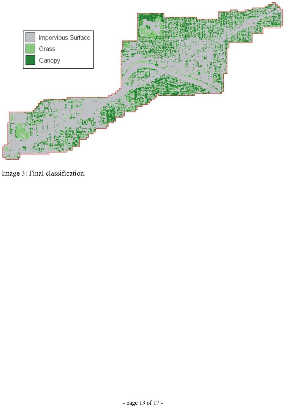
5 mostly commercial and industrial areas on either side. Further away from its major arterial, residential areas dominate. I-84 crosses Sandy Boulevard, thereby dividing the study area in an Eastern and Western half. Notable features include Benson High School, Grant High School, and Oregon Park. Image 1 illustrates the study area with its main features labeled, and image 2 provides a detailed look at land use. In order to perform the analysis, the digital aerial photography used was reduced to the extent of the land use data. The land use data, available in vector format, was rasterized to 1-meter pixels and then georeferenced to match the feature boundaries of the aerial-photography layers. Tree Canopy Classification An unsupervised classification was performed with IDRISI software and resulted in three classes grass, canopy, and impervious surface. The green, red, infrared, and a red-infrared ratio of the 1-meter resolution digital imagery were used as input layers to produce 30 clusters that were then collapsed into the three different land-cover classes. In an article on urban mapping methods with high-resolution imagery, Thomas et al. write that although digital 1-meter imagery works well for distinguishing features in mixed urban areas, the high-resolution data has the disadvantage of great within-class spectral variation (963). Such variation within the canopy class caused confusion between the grass and canopy at several spots. Areas that should have been canopy were falsely combined with areas of grass, despite the fact that the classification algorithm produced 30 clusters. Splitting of the clusters that caused the confusion into subclusters solved the problem and most of the confused pixels were classified correctly. The final classification (Image 3) yielded an overall accuracy of approximately 78%, with an accuracy of - page 5 of 17 -

6 about 90% for the impervious-surface class and accuracies of 74% and 77% for the canopy and grass classes, respectively. Current Tree Canopy & Land Use After the land cover classification was completed, it was combined with the land use data by using a cross-tabulation process that related each pixel of the land cover map to each pixel of the land use map. It needs to be noted that the land use data do not include the areas that are covered by streets. Therefore all square-meter pixels that fall on a street are excluded for this part of the study. Table 1 shows how much area in each land-cover class is covered by canopy, grass, and impervious surface. For example, Hollywood s single-family residential area has 203,646 pixels (~50.3 acres) of tree canopy, which is 30.8% of the whole single-family residential class in the study area. On the other hand, the industrial area has only 1,983 pixels (~0.5 acres) of tree canopy or 1.9% of the whole industrial area. At the bottom of table 1, some land-use categories are collapsed into the more general classes of residential, commercial/industrial, and institutional/vacant. The numbers show that an expected pattern emerges, where the commercial and industrial areas have much less tree canopy cover than any of the other land use classes. Images 4, 5, and 6 illustrate how canopy cover, grass, and impervious surface are distributed spatially within the three generalized land use categories. A recent study on Portland s tree canopy cover suggests a recommended tree-canopy target value of 47% for residential areas and 12% for commercial/industrial areas (Poracsky & Lackner 2004). Table 1 shows that Portland s Hollywood district does not meet these suggested values, although it needs to be mentioned that the street trees that are located in the various landuse classes are excluded. Even if the street trees were included, the residential and - page 6 of 17 -

7 commercial/industrial areas would still be below the recommended target values for canopy cover. However, if all grass areas of the residential area would be trees, the tree canopy percentage would increase to 43.1%. Likewise, the commercial / industrial area s canopy percentage would go up to 10.1% if all of its grass area would be covered by trees. These values would almost reach the recommendations. Maximizing and Expanding Tree Canopy According to Reynolds and Dimon, between 150 and 175 tree species grow well in the Willamette Valley, and 22 of the 48 species native to Oregon, 22 are native to the Greater Portland area ( ). In the study area there are approximately 79 acres, excluding ball fields, of grassy area that could provide tree-planting space. Maybe not all of the grass area is suitable or desirable for additional trees, but there appear to be adequate opportunities to increase the tree canopy in the study area. It is essential to choose the right tree for the right location by considering planting constraints, such as utility poles, buildings, or narrow planting strips. Tree characteristics, including height, leaf density, spread, among others must be chosen carefully to fit the planting location. While this study did not explore all these characteristics, it examined the little-explored factors of tree shape (spreading vs. columnar), the spacing between trees, and their implications for the number of trees needed to cover potential planting areas. The spread of a tree is closely related to the area that the tree crown will cover when the tree matures. Two trees that are native to the area will be used in the following example. The spreading tree Acer platanoides (Crimson King Norway Maple) can cover an area of approximately 113 to 177 square feet after a ten years and about 177 to 314 square feet another decade later. The square footage for the columnar tree Calocedrus decurrens (Incense Cedar) is - page 7 of 17 -

8 about 7 to 20 and 13 to 28 over the same time periods. Allowing a period of twenty years of tree growth, it would take 334 of the above mentioned maples and 4,008 of the cedars to cover the 4.6 acres of grass zone in the commercial/industrial area. The step-by-step description of how this calculation was performed is described below: 1. Planting space 4.6 acres = 200,376 square feet 2. Divide planting space by 2 for planting the 2 different species 2 areas of each 100,188 square feet 3. Divide the potential planting area for each species (100,188 square feet) by the square footage of each species Maple: 300 square feet (after 20 years), Cedar: 45 square feet (after 20 years) Maple: 100,188 / 300 = (334 trees) Cedar: 100,188 / 45 = 4, (4,008 trees) This is of course only a very simplified calculation, but it can be refined to include different tree species, spacing between trees, and specified tree planting areas instead of the whole commercial/industrial area as used in the example just described. Table 2 illustrates how many trees would be necessary to cover the grass areas of the different land use classes, providing four different tree spreads. Examples for trees [maybe include one more exmpl deciduous columnar] with these spreads can be found in Arboriculture literature. However, increased distance between trees decreases the amount of available planting space. Graph 1 illustrates how increased spacing between trees limits the possible tree-planting space of the study area. Given the spread of a tree and possible planting areas, city planners can calculate a number of scenarios in the same way as the example just described. Further Study & Conclusion This study only considered grass areas as possible tree planting sites because they were fairly easy to detect with the used classification method; these sites are also cost-efficient - page 8 of 17 -
 by the square footage of each species Maple: 300 square feet (after 20 years), Cedar: 45 square feet (after 20 years) Maple:")
9 because no concrete cuts need to be made, as is the case with possible planting sites on sidewalks or parking lots. Further research could examine these additional planting sites as well as areas of bare soil, gravel, and shrub, along with the associated costs of all possible planting sites. In order to determine the feasibility of a planting space, additional geospatial data, such as building outlines and power-line locations could be used to categorize the areas under consideration. This would help in narrowing down possible planting sites, thereby limiting the number of field checks in order to determine the final sites. These additional data could also aid in the choice of the tree types that can be planted at a certain location. While this study does not attempt to provide a comprehensive method of managing the urban forest, it offers a fairly inexpensive way for estimating urban forest canopy extent and possibilities for increasing it. The described methodology of this study can be applied to other urban areas of similar size, giving city planners tools they can use to accomplish their goal to maximize the city s tree canopy. - page 9 of 17 -

10 References City of Portland Portland s Urban Forestry Management Plan (Draft Revision). Portland, OR: Bureau of Parks and Recreation. Harris, Richard W Arboriculture; Integrated Management of Landscape Trees, Shrubs, and Vines. Second Edition. Englewood Cliffs, NJ: Regents/Prentice Hall. Miller, Robert W Urban Forestry; Planning and Managing Urban Greenspaces. Second Edition. Upper Saddle River, NJ: Prentice Hall. Poracsky, Joseph and Michael Lackner. Urban Forest Canopy Cover in Portland, Oregon, Final Project Report. Prepared for Portland General Electric and City of Portland Urban Forestry Commission. (currently In Review). Reynolds, Phyllis and C. Elizabeth Dimon Trees of Greater Portland. Portland, OR: Timber Press. Thomas, Nancy, Chad Hendrix, Russell G. Congalton. September A Comparison of Urban Mapping Methods Using High-Resolution Digital Imagery. Photogrammetric Engineering & Remote Sensing 69 (9): page 10 of 17 -
.")
11 Appendix Image 1: Study area with main features and locator map. - page 11 of 17 -

12 Image 2: Detailed land use classes for the study area. - page 12 of 17 -

13 Image 3: Final classification. - page 13 of 17 -
14 Land Cover: Impervious Grass Trees Total Landuse Residential: Single Family % Residential: Duplex % Residential: Multi Family % Commercial % Industrial % Vacant % Institutional % Total % Residential % Commercial / Industrial % Institutional / Vacant % Table1: Land cover classes are related to land use classes. - page 14 of 17 -

15 Images 4, 5, 6: Land cover compared to land use. - page 15 of 17 -

16 Land Use Grass Area Spread 1 Spread 2 Spread 3 Spread 4 (in Acres) (55 sq.f) (97 sq.f) (194 sq.f) (300 sq.f) Commercial/Industrial 4.6 3,759 2,088 1, Institutional/Vacant ,159 10,644 5,322 3,421 Residential ,456 13,586 6,793 4,367 Table 2: Number of trees with various spreads that are needed to cover the grass area of a certain land-use class - page 16 of 17 -

17 Planting area (square meters) 400, , , , , , ,000 50, Spacing between trees (feet) Graph 1: As the spacing between trees increases, the available tree planting area decreases. - page 17 of 17 -

MAPPING MINNEAPOLIS URBAN TREE CANOPY. Why is Tree Canopy Important? Project Background. Mapping Minneapolis Urban Tree Canopy.
 MAPPING MINNEAPOLIS URBAN TREE CANOPY Why is Tree Canopy Important? Trees are an important component of urban environments. In addition to their aesthetic value, trees have significant economic and environmental
Background research on the topic of urban forestry is intended to
 overview urban forestry Urban Forestry Background research on the topic of urban forestry is intended to help guide the task of integrating trees and urban forestry goals and aspirations into the Portland
Remote Sensing and Land Use Classification: Supervised vs. Unsupervised Classification Glen Busch
 Remote Sensing and Land Use Classification: Supervised vs. Unsupervised Classification Glen Busch Introduction In this time of large-scale planning and land management on public lands, managers are increasingly
A Report on the City of Philadelphia s Existing and Possible Tree Canopy
 A Report on the City of Philadelphia s Existing and Possible Tree Canopy Why is Tree Canopy Important? Tree canopy (TC) is the layer of leaves, branches, and stems of trees that cover the ground when viewed
TREE CANOPY. August 6 2014
 TREE CANOPY August 6 2014 Tree Canopy Benefits 2 Beautification Reduce the heat island effect Reduces Stormwater Runoff SANDY SPRINGS TREE CANOPY July, 2014 Canopy Studies - 1991, 2001 and 2005 4 UGA Institute
Digital Classification and Mapping of Urban Tree Cover: City of Minneapolis
 Digital Classification and Mapping of Urban Tree Cover: City of Minneapolis FINAL REPORT April 12, 2011 Marvin Bauer, Donald Kilberg, Molly Martin and Zecharya Tagar Remote Sensing and Geospatial Analysis
Urban Ecosystem Analysis For the Houston Gulf Coast Region Calculating the Value of Nature
 December 2000 Urban Ecosystem Analysis For the Houston Gulf Coast Region Calculating the Value of Nature Report Contents 2-3 Project Overview and Major Findings 4 Regional Level Analysis 5-7 Local Level
Urban Ecosystem Analysis San Antonio, TX Region
 November 2002 Urban Ecosystem Analysis San Antonio, TX Region Calculating the Value of Nature Report Contents 2 Project Overview and Major Findings 3 Greater San Antonio Area Regional Ecosystem Analysis
2006 Boise Community Forestry Report Card completed January 2015
 2006 Boise ommunity Forestry Report ard completed January 2015 In 2006, as part of Boise s last 10-year ommunity Forest Management Plan, the Les Bois Tree Task Force developed 23 Top Priority Recommendations.
JACIE Science Applications of High Resolution Imagery at the USGS EROS Data Center
 JACIE Science Applications of High Resolution Imagery at the USGS EROS Data Center November 8-10, 2004 U.S. Department of the Interior U.S. Geological Survey Michael Coan, SAIC USGS EROS Data Center coan@usgs.gov
Open Forum: Tree Preservation Town of Morrisville 7.24.14
 Open Forum: Tree Preservation Town of Morrisville 7.24.14 Chad Meadows, AICP Public & Private Sector Planner Drafted 16 Development Codes Co-Author, Local Tree Protection Ordinances in North Carolina Congressional
Understanding Raster Data
 Introduction The following document is intended to provide a basic understanding of raster data. Raster data layers (commonly referred to as grids) are the essential data layers used in all tools developed
AERIAL PHOTOGRAPHS. For a map of this information, in paper or digital format, contact the Tompkins County Planning Department.
 AERIAL PHOTOGRAPHS What are Aerial Photographs? Aerial photographs are images of the land taken from an airplane and printed on 9 x9 photographic paper. Why are Aerial Photographs Important? Aerial photographs
Urban Ecosystem Analysis Atlanta Metro Area Calculating the Value of Nature
 August 2001 Urban Ecosystem Analysis Atlanta Metro Area Calculating the Value of Nature Report Contents 2 Project Overview and Major Findings 3 Regional Analysis 4 Local Analysis 6 Using Regional Data
BASSETT CREEK VALLEY MASTER PLAN OPEN HOUSE
 BASSETT CREEK VALLEY MASTER PLAN OPEN HOUSE February 23, 2006 PROJECT INTRODUCTION Project Area 230 acres $50 million estimated market value (approximately) 50 acres parkland 100 residences (estimated)
GULF COASTAL URBAN FOREST HAZARD ASSESSMENT AND REMOTE SENSING EFFORTS AFTER HURRICANES KATRINA AND RITA 1
 GULF COASTAL URBAN FOREST HAZARD ASSESSMENT AND REMOTE SENSING EFFORTS AFTER HURRICANES KATRINA AND RITA 1 Kamran K. Abdollahi, Zhu Hua Ning, Daniel Collins, Fulbert Namwamba and Asebe Negatu SU Agricultural
Extending Enterprise GIS Into The Field with Mobile GIS Technology
 Extending Enterprise GIS Into The Field with Mobile GIS Technology A White Paper January 10, 2014 1525 Oregon Pike Suite 202 Lancaster, PA 17601-7300 Phone (717) 399-7007 Fax (717) 399-7015 www.geographit.com
APPLICATION OF GOOGLE EARTH FOR THE DEVELOPMENT OF BASE MAP IN THE CASE OF GISH ABBAY SEKELA, AMHARA STATE, ETHIOPIA
 APPLICATION OF GOOGLE EARTH FOR THE DEVELOPMENT OF BASE MAP IN THE CASE OF GISH ABBAY SEKELA, AMHARA STATE, ETHIOPIA Abineh Tilahun Department of Geography and environmental studies, Adigrat University,
COASTAL MONITORING & OBSERVATIONS LESSON PLAN Do You Have Change?
 Coastal Change Analysis Lesson Plan COASTAL MONITORING & OBSERVATIONS LESSON PLAN Do You Have Change? NOS Topic Coastal Monitoring and Observations Theme Coastal Change Analysis Links to Overview Essays
Increasing water availability through juniper control.
 Tim Deboodt, OSU Crook County Extension Agent 498 SE Lynn Blvd. Prineville, OR 97754 541-447-6228 Tim.deboodt@oregonstate.edu Increasing water availability through juniper control. Throughout the region
Land Use/Land Cover Map of the Central Facility of ARM in the Southern Great Plains Site Using DOE s Multi-Spectral Thermal Imager Satellite Images
 Land Use/Land Cover Map of the Central Facility of ARM in the Southern Great Plains Site Using DOE s Multi-Spectral Thermal Imager Satellite Images S. E. Báez Cazull Pre-Service Teacher Program University
Using Aerial Photography to Measure Habitat Changes. Method
 Then and Now Using Aerial Photography to Measure Habitat Changes Method Subject Areas: environmental education, science, social studies Conceptual Framework Topic References: HIIIB, HIIIB1, HIIIB2, HIIIB3,
The Application of Land Use/ Land Cover (Clutter) Data to Wireless Communication System Design
 Data to Wireless Communication System Design") Technology White Paper The Application of Land Use/ Land Cover (Clutter) Data to Wireless Communication System Design The Power of Planning 1 Harry Anderson, Ted Hicks, Jody Kirtner EDX Wireless, LLC Eugene,
Technology White Paper The Application of Land Use/ Land Cover (Clutter) Data to Wireless Communication System Design The Power of Planning 1 Harry Anderson, Ted Hicks, Jody Kirtner EDX Wireless, LLC Eugene,
WATER BODY EXTRACTION FROM MULTI SPECTRAL IMAGE BY SPECTRAL PATTERN ANALYSIS
 WATER BODY EXTRACTION FROM MULTI SPECTRAL IMAGE BY SPECTRAL PATTERN ANALYSIS Nguyen Dinh Duong Department of Environmental Information Study and Analysis, Institute of Geography, 18 Hoang Quoc Viet Rd.,
A GUIDE: DEVELOPING A STREET AND PARK TREE MANAGEMENT PLAN
 A GUIDE: DEVELOPING A STREET AND PARK TREE MANAGEMENT PLAN An introduction to the preparation of a strategic approach to the care and maintenance of your community forest USDA Forest Service Northeastern
Conducting a Land Use Inventory
 Chapter 3 Conducting a Land Use Inventory Included in this chapter: Determining Current Land Use Conditions Preparing a Base Map Deciding on Land Use Categories Collecting Current Land Use Data Preparing
Objectives. Raster Data Discrete Classes. Spatial Information in Natural Resources FANR 3800. Review the raster data model
 Spatial Information in Natural Resources FANR 3800 Raster Analysis Objectives Review the raster data model Understand how raster analysis fundamentally differs from vector analysis Become familiar with
Portland State University. Campus Tree Care Plan
 Portland State University Campus Tree Care Plan 1. Purpose Portland State University (PSU) resides in a densely populated urban setting in downtown Portland, Oregon. With green space in short supply, maintaining
Development of an Impervious-Surface Database for the Little Blackwater River Watershed, Dorchester County, Maryland
 Development of an Impervious-Surface Database for the Little Blackwater River Watershed, Dorchester County, Maryland By Lesley E. Milheim, John W. Jones, and Roger A. Barlow Open-File Report 2007 1308
Environmental Remote Sensing GEOG 2021
 Environmental Remote Sensing GEOG 2021 Lecture 4 Image classification 2 Purpose categorising data data abstraction / simplification data interpretation mapping for land cover mapping use land cover class
Buffelgrass Growth within Urban Sub-Habitats Using High Resolution Aerial Photography
 Buffelgrass Growth within Urban Sub-Habitats Using High Resolution Aerial Photography Spencer Padgett spadgett@email.arizona.edu The University of Arizona School of Geography and Development Introduction
Chapter 5.0. Stormwater Credits for Innovative Site Planning
 Chapter 5.0 Stormwater Credits for Innovative Site Planning Chapter 5. Stormwater Credits...Introduction 5.0 Stormwater Credits In Maryland, there are many programs at both the State and local level that
Chapter 7 ZONING PLAN
 Chapter 7 ZONING PLAN Introduction This Chapter opens with a general description of a zoning plan. It is followed by a brief explanation of the relationship between this Growth Management Plan and the
Land Use/ Land Cover Mapping Initiative for Kansas and the Kansas River Watershed
 Land Use/ Land Cover Mapping Initiative for Kansas and the Kansas River Watershed Kansas Biological Survey Kansas Applied Remote Sensing Program April 2008 Previous Kansas LULC Projects Kansas LULC Map
Quantifying LID Triple Bottom Line Benefits Milwaukee Case Study Kimberly Brewer, A.I.C.P. Tetra Tech
 Quantifying LID Triple Bottom Line Benefits Milwaukee Case Study Kimberly Brewer, A.I.C.P. Tetra Tech Karen Sands, Manager of Sustainability, MMSD Heather Fisher, AICP, Tetra Tech 1 Background MMSD provides
DETECTING LANDUSE/LANDCOVER CHANGES ALONG THE RING ROAD IN PESHAWAR CITY USING SATELLITE REMOTE SENSING AND GIS TECHNIQUES
 ------------------------------------------------------------------------------------------------------------------------------- Full length Research Paper -------------------------------------------------------------------------------------------------------------------------------
City of Bellingham Tree Planting Guide
 City of Bellingham Tree Planting Guide This guide provides you with resources for planting trees in the city. Using the right tree in the right place, and maintaining it correctly will provide healthy,
Natural Resource-Based Planning*
 Natural Resource-Based Planning* Planning, when done well, is among the most powerful tools available to communities. A solid plan, based on good natural resource information, guides rational land-use
ELMER AVENUE. Water Augmentation Study NEIGHBORHOOD RETROFIT DEMONSTRATION PROJECT
 ELMER AVENUE Water Augmentation Study NEIGHBORHOOD RETROFIT DEMONSTRATION PROJECT STAGG STREET ELMER AVENUE KESWICK STREET PASEO NOTE: Photo taken before retrofit WHAT IS THE NEIGHBORHOOD RETROFIT PROJECT?
Summary of Pre- and Post-Project Vegetation Survey Results
 3921 East Bayshore Road Palo Alto CA 94303-4326 tel 650.962.9876 fax 650.962.8234 www.acterra.org info@acterra.org Introduction Summary of Pre- and Post-Project Vegetation Survey Results Acterra Stewardship
Application of Remotely Sensed Data and Technology to Monitor Land Change in Massachusetts
 Application of Remotely Sensed Data and Technology to Monitor Land Change in Massachusetts Sam Blanchard, Nick Bumbarger, Joe Fortier, and Alina Taus Advisor: John Rogan Geography Department, Clark University
Mobile Network Base Station Design Guide User Manual
 Mobile Network Base Station Design Guide User Manual Prepared for the Mobile Carriers Forum and the Design and Innovation Programme Taskforce February 2008 Consultant Contact: Nicole Halsey, Director Urban
The LAndscape Management Policy Simulator (LAMPS) Pete Bettinger Department of Forest Resources Oregon State University
 Pete Bettinger Department of Forest Resources Oregon State University") The LAndscape Management Policy Simulator (LAMPS) Pete Bettinger Department of Forest Resources Oregon State University CLAMS Landscape Planning and Analysis Process Existing forest inventories Management
The LAndscape Management Policy Simulator (LAMPS) Pete Bettinger Department of Forest Resources Oregon State University CLAMS Landscape Planning and Analysis Process Existing forest inventories Management
How To Plan A Buffer Zone
 Backyard Buffers Protecting Habitat and Water Quality What is a buffer? A buffer (also called a riparian buffer area or zone) is the strip of natural vegetation along the bank of a stream, lake or other
Backyard Buffers that Work for People and Nature by Restoring Ecological Function
 Backyard Buffers that Work for People and Nature by Restoring Ecological Function What is a Wetland Buffer? A wetland buffer is a simple land management practice that is employed by municipalities to protect
Nature Values Screening Using Object-Based Image Analysis of Very High Resolution Remote Sensing Data
 Nature Values Screening Using Object-Based Image Analysis of Very High Resolution Remote Sensing Data Aleksi Räsänen*, Anssi Lensu, Markku Kuitunen Environmental Science and Technology Dept. of Biological
Construction Guidelines for Tree Protection. d. DISTRICT DEPARTMENT OF TRANSPORTATION URBAN FORESTRY ADMINISTRATION
 Construction Guidelines for Tree Protection d. DISTRICT DEPARTMENT OF TRANSPORTATION URBAN FORESTRY ADMINISTRATION City of Trees Our time in history Since 1872, when Governor Alexander Shepherd planted
UPPER COLUMBIA BASIN NETWORK VEGETATION CLASSIFICATION AND MAPPING PROGRAM
 UPPER COLUMBIA BASIN NETWORK VEGETATION CLASSIFICATION AND MAPPING PROGRAM The Upper Columbia Basin Network (UCBN) includes nine parks with significant natural resources in the states of Idaho, Montana,
APPLICATION FOR CLASSIFICATION OF FOREST LAND
 To the Chief, Division of Forestry: APPLICATION FOR CLASSIFICATION OF FOREST LAND In accordance with sections 5713.22-.26 of the Ohio Revised Code, I hereby apply for the classification of certain lands
Comparison of Satellite Imagery and Conventional Aerial Photography in Evaluating a Large Forest Fire
 Purdue University Purdue e-pubs LARS Symposia Laboratory for Applications of Remote Sensing --98 Comparison of Satellite Imagery and Conventional Aerial Photography in Evaluating a Large Forest Fire G.
6. NATURAL AREAS FIRE MANAGEMENT
 6. NATURAL AREAS FIRE MANAGEMENT 6-1 Wildfire management is an important component of managing and maintaining County natural areas. The natural areas are woven into the community fabric and are a part
APPLICATION OF ALOS DATA FOR LAND USE CHANGE IN GREEN AREA OF BANG KA CHAO, SAMUT PRAKAN PROVINCE
 APPLICATION OF ALOS DATA FOR LAND USE CHANGE IN GREEN AREA OF BANG KA CHAO, SAMUT PRAKAN PROVINCE Chanika Sukawattanavijit, Ekkarat Pricharchon Geo-Informatics Scientist Geo-Informatics and Space Technology
Nature in Neighborhoods: Community Stewardship Grant Pre- Application
 Nature in Neighborhoods: Community Stewardship Grant Pre- Application A. Organization, project and contact information Date of application Organization April 21, 2015 (ANTT) Albina Neighborhood Tree Team
Nowak D.J. USDA Forest Service, Northeastern Research Station, Syracuse, NY,USA
 URBAN FORESTRY Nowak D.J. USDA Forest Service, Northeastern Research Station, Syracuse, NY,USA Dwyer J.F. USDA Forest Service, North Central Research Station, Evanston, IL,USA Keywords: Urban forests,
Coastal Engineering Indices to Inform Regional Management
 Coastal Engineering Indices to Inform Regional Management Lauren Dunkin FSBPA 14 February 2013 Outline Program overview Standard products Coastal Engineering Index Conclusion and future work US Army Corps
FOR SALE. The Friedman Building 1701 18th Avenue South, Seattle 98144. Nicholas T. Gill 206.505.9410. Allan Friedman. 206.505.
 FOR SALE FOR MORE INFORMATION PLEASE CONTACT: The Friedman Building 1701 18th Avenue South, Seattle 98144 PRICE: $4,800,000 FEATURES: LAND SF: 40,000 SF + Fantastic Large Townhome Site BUILDING SF: 33,332
Post-Wildfire Clean-Up and Response in Houston Toad Habitat Best Management Practices
 Post-Wildfire Clean-Up and Response in Houston Toad Habitat Best Management Practices Purpose The purpose of this document is to provide guidance and recommendations for minimizing potential impacts to
RULE INHERITANCE IN OBJECT-BASED IMAGE CLASSIFICATION FOR URBAN LAND COVER MAPPING INTRODUCTION
 RULE INHERITANCE IN OBJECT-BASED IMAGE CLASSIFICATION FOR URBAN LAND COVER MAPPING Ejaz Hussain, Jie Shan {ehussain, jshan}@ecn.purdue.edu} Geomatics Engineering, School of Civil Engineering, Purdue University
Remote Sensing and GIS Application In Change Detection Study In Urban Zone Using Multi Temporal Satellite
 Remote Sensing and GIS Application In Change Detection Study In Urban Zone Using Multi Temporal Satellite R.Manonmani, G.Mary Divya Suganya Institute of Remote Sensing, Anna University, Chennai 600 025
1 Portland State University. 506 SW Mill St., Suite 750, Portland, OR 97201 Telephone: 1 (971) 404-1843 Email: jvoelkel@pdx.edu
 404-1843 Email: jvoelkel@pdx.edu") Geocomputation for Urban Planning in the era of big data: Developing automated tools for analyzing lidar data to inform urban planning and policy in Portland, OR J. L. Voelkel 1, V. Shandas 2, M. Rao 3,
Geocomputation for Urban Planning in the era of big data: Developing automated tools for analyzing lidar data to inform urban planning and policy in Portland, OR J. L. Voelkel 1, V. Shandas 2, M. Rao 3,
Review for Introduction to Remote Sensing: Science Concepts and Technology
 Review for Introduction to Remote Sensing: Science Concepts and Technology Ann Johnson Associate Director ann@baremt.com Funded by National Science Foundation Advanced Technological Education program [DUE
Land Cover Mapping of the Comoros Islands: Methods and Results. February 2014. ECDD, BCSF & Durrell Lead author: Katie Green
 Land Cover Mapping of the Comoros Islands: Methods and Results February 2014 ECDD, BCSF & Durrell Lead author: Katie Green About the ECDD project The ECDD project was run by Bristol Conservation & Science
Multiscale Object-Based Classification of Satellite Images Merging Multispectral Information with Panchromatic Textural Features
 Remote Sensing and Geoinformation Lena Halounová, Editor not only for Scientific Cooperation EARSeL, 2011 Multiscale Object-Based Classification of Satellite Images Merging Multispectral Information with
Assessing Hurricane Katrina Damage to the Mississippi Gulf Coast Using IKONOS Imagery
 Assessing Hurricane Katrina Damage to the Mississippi Gulf Coast Using IKONOS Imagery Joseph P. Spruce Science Systems and Applications, Inc. John C., MS 39529 Rodney McKellip NASA Project Integration
TAMARISK MAPPING & MONITORING USING HIGH RESOLUTION SATELLITE IMAGERY. Jason W. San Souci 1. John T. Doyle 2
 TAMARISK MAPPING & MONITORING USING HIGH RESOLUTION SATELLITE IMAGERY Jason W. San Souci 1 John T. Doyle 2 ABSTRACT QuickBird high resolution multispectral satellite imagery (60 cm GSD, 4 spectral bands)
SAMPLE MIDTERM QUESTIONS
 Geography 309 Sample MidTerm Questions Page 1 SAMPLE MIDTERM QUESTIONS Textbook Questions Chapter 1 Questions 4, 5, 6, Chapter 2 Questions 4, 7, 10 Chapter 4 Questions 8, 9 Chapter 10 Questions 1, 4, 7
A GIS helps you answer questions and solve problems by looking at your data in a way that is quickly understood and easily shared.
 A Geographic Information System (GIS) integrates hardware, software, and data for capturing, managing, analyzing, and displaying all forms of geographically referenced information. GIS allows us to view,
L A N D S C A P E P A T T E R N S
 A PATTERN BOOK FOR NEIGHBORLY HOUSES LANDSCAPE PATTERNS E Landscape Patterns Throughout the United States there is an incredible range of climatic zones, microclimates, plant species, and landscape traditions.
City of Dublin Landscape Requirements Land Use and Long Range Planning
 City of Dublin Landscape Requirements Land Use and Long Range Planning 2009 PURPOSE Dublin s high quality of life is promoted through minimum landscape requirements on commercial developments. Landscaping
Remote Sensing of Environment
 Remote Sensing of Environment 115 (2011) 1145 1161 Contents lists available at ScienceDirect Remote Sensing of Environment journal homepage: www.elsevier.com/locate/rse Per-pixel vs. object-based classification
Assessing the implementation of Rawalpindi s Guided Development Plan through GIS and Remote Sensing Muhammad Adeel
 Assessing the implementation of Rawalpindi s Guided Development Plan through GIS and Remote Sensing Muhammad Adeel (Lecturer Muhammad Adeel, Institute of Geographical Information Systems, NUST, H-12 Islamabad,
Summary of the Heritage Tree Ordinance Updated July 2013
 Summary of the Heritage Tree Ordinance Updated July 2013 Purpose of the Ordinance See also: Chapter 13.24 of the Menlo Park Municipal Code (Available at www.menlopark.org or by calling 330-6740) The City
Mapping coastal landscapes in Sri Lanka - Report -
 Mapping coastal landscapes in Sri Lanka - Report - contact : Jil Bournazel jil.bournazel@gmail.com November 2013 (reviewed April 2014) Table of Content List of Figures...ii List of Tables...ii Acronyms...ii
Projected Environmental Benefits of Community Tree Planting
 October 2002 Projected Environmental Benefits of Community Tree Planting A Multi-Site Model Urban Forest Project in Atlanta Report Contents 2 Project Overview 3 Major Findings 4 Environmental Benefits
Using Remote Sensing Imagery to Evaluate Post-Wildfire Damage in Southern California
 Graham Emde GEOG 3230 Advanced Remote Sensing February 22, 2013 Lab #1 Using Remote Sensing Imagery to Evaluate Post-Wildfire Damage in Southern California Introduction Wildfires are a common disturbance
Introduction to GIS (Basics, Data, Analysis) & Case Studies. 13 th May 2004. Content. What is GIS?
 & Case Studies. 13 th May 2004. Content. What is GIS?") Introduction to GIS (Basics, Data, Analysis) & Case Studies 13 th May 2004 Content Introduction to GIS Data concepts Data input Analysis Applications selected examples What is GIS? Geographic Information
Introduction to GIS (Basics, Data, Analysis) & Case Studies 13 th May 2004 Content Introduction to GIS Data concepts Data input Analysis Applications selected examples What is GIS? Geographic Information
Nevada Pinyon-Juniper Partnership Proposed Demonstration Area A Brief Introduction. Presented by Jeremy Drew Project Manager Resource Concepts, Inc.
 Nevada Pinyon-Juniper Partnership Proposed Demonstration Area A Brief Introduction Presented by Jeremy Drew Project Manager Resource Concepts, Inc. What I ll Discuss: Purpose of a Demonstration Area Priorities
APPENDIX F. RESIDENTIAL WATER QUALITY PLAN: ALLOWABLE BMP OPTIONS
 APPENDIX F. RESIDENTIAL WATER QUALITY PLAN: ALLOWABLE BMP OPTIONS The following section provides descriptions, advantages, limitations, and schematics of allowable best management practices (BMPs) for
City of Cambridge Climate Protection Action Committee. Recommendation to the City Manager on Urban Heat Island Mitigation
 City of Cambridge Climate Protection Action Committee Recommendation to the City Manager on Urban Heat Island Mitigation Recommendation to take actions that mitigate and increase awareness of the urban
Supervised Classification workflow in ENVI 4.8 using WorldView-2 imagery
 Supervised Classification workflow in ENVI 4.8 using WorldView-2 imagery WorldView-2 is the first commercial high-resolution satellite to provide eight spectral sensors in the visible to near-infrared
Urban Tree Canopy Plan and Goals. Jefferson County, West Virginia
 Urban Tree Canopy Plan and Goals Jefferson County, West Virginia Approved by Jefferson County Commission November 3, 2011 Table of Contents Chapter 1: Background/Purpose 1 Chapter 2: Benefits of Trees...3
Prioritizing Riparian Restoration at the Watershed, Reach and Site Scales. Richard R. Harris University of California, Berkeley Cooperative Extension
 Prioritizing Riparian Restoration at the Watershed, Reach and Site Scales Richard R. Harris University of California, Berkeley Cooperative Extension Issues Riparian communities provide multiple benefits
Rural Residential Buildable Lands Inventory
 The Dalles Periodic Review, May 2013 Rural Residential Lands Inventory Contents Introduction and Summary... 1 Concerns related to the 2007 Analysis... 2 Rural Residential Capacity Summary... 2 Methodology...
Richmond City s Green Infrastructure Assessment
 Richmond City s Green Infrastructure Assessment Presented by Karen Firehock, Director The Green Infrastructure Center Inc. www.gicinc.org Mike Mather, City Arborist City of Richmond Winter Symposium --
DO's and DON'Ts in Pruning
 DO's and DON'Ts in Pruning Introduction "Pruning is one of the best things an arborist can do for a tree but one of the worst things we can do to a tree" -Alex Shigo Pruning is the most common tree maintenance
Assume you have 40 acres of forestland that was
 A l a b a m a A & M a n d A u b u r n U n i v e r s i t i e s ANR-1371 Basal Area: A Measure Made for Management Assume you have 40 acres of forestland that was recently assessed by a natural resource
RESOLUTION MERGE OF 1:35.000 SCALE AERIAL PHOTOGRAPHS WITH LANDSAT 7 ETM IMAGERY
 RESOLUTION MERGE OF 1:35.000 SCALE AERIAL PHOTOGRAPHS WITH LANDSAT 7 ETM IMAGERY M. Erdogan, H.H. Maras, A. Yilmaz, Ö.T. Özerbil General Command of Mapping 06100 Dikimevi, Ankara, TURKEY - (mustafa.erdogan;
(Seattle, WA, More than 500,001, Green Seattle Partnership)
") (Seattle, WA, More than 500,001, Green Seattle Partnership) Project Summary The Green Seattle Partnership is a collaboration between the City of Seattle, Cascade Land Conservancy and our residents to restore
(Seattle, WA, More than 500,001, Green Seattle Partnership) Project Summary The Green Seattle Partnership is a collaboration between the City of Seattle, Cascade Land Conservancy and our residents to restore
Strategic Urban Forests Assessment: Baltimore, Maryland INTRODUCTION
 Strategic Urban Forests Assessment: Baltimore, Maryland Frederick M. Irani, Remote Sensing and GIS, Chesapeake and Coastal Watershed Service Watershed Management and Analysis Michael F. Galvin, Supervisor,
SECTION ONE CHAPTER 2: A LAND USE PROFILE OF MANCHESTER
 SECTION ONE CHAPTER 2: A LAND USE PROFILE OF MANCHESTER Land use is the central element of a comprehensive plan because it establishes the overall physical configuration of the city, including the mix
Urban Ecosystem Analysis Miami-Dade County UDB and the City of Miami, Florida
 May 2008 Urban Ecosystem Analysis Miami-Dade County UDB and the, Florida Calculating the Value of Nature Report Contents 2 Project Overview 2 Background 4 Major Landcover Change Findings 5 2004-2006 Landcover
CIESIN Columbia University
 Conference on Climate Change and Official Statistics Oslo, Norway, 14-16 April 2008 The Role of Spatial Data Infrastructure in Integrating Climate Change Information with a Focus on Monitoring Observed
3D Model of the City Using LiDAR and Visualization of Flood in Three-Dimension
 3D Model of the City Using LiDAR and Visualization of Flood in Three-Dimension R.Queen Suraajini, Department of Civil Engineering, College of Engineering Guindy, Anna University, India, suraa12@gmail.com
Corridor Goals and Objectives
 Corridor Goals and Objectives This chapter presents the goals and objectives, developed by the Corridor Study Committee, that serve as the purpose and intent of the Corridor Plan. This plan covers a twenty
THE OBJECT-BASED APPROACH FOR URBAN LAND USE CLASSIFICATION USING HIGH RESOLUTION SATELLITE IMAGERY (A CASE STUDY ZANJAN CITY)
") Proceedings of the 4th GEOBIA, May 7-9, 2012 - Rio de Janeiro - Brazil. p.678 THE OBJECT-BASED APPROACH FOR URBAN LAND USE CLASSIFICATION USING HIGH RESOLUTION SATELLITE IMAGERY (A CASE STUDY ZANJAN CITY)
Proceedings of the 4th GEOBIA, May 7-9, 2012 - Rio de Janeiro - Brazil. p.678 THE OBJECT-BASED APPROACH FOR URBAN LAND USE CLASSIFICATION USING HIGH RESOLUTION SATELLITE IMAGERY (A CASE STUDY ZANJAN CITY)
From GPS Data Collection to GIS Data Display A Walk-Through Example
 From GPS Data Collection to GIS Data Display A Walk-Through Example The Global Positioning System (GPS) is a satellite based navigation system consisting of 24 satellites, a worldwide network of tracking
Measuring Density: Working Definitions for Residential Density and Building Intensity
 Design Center for American Urban Landscape Design Brief, Number 8/ July 2003 Measuring Density: Working Definitions for Residential Density and Building Intensity Ann Forsyth, Director November 2003 Measuring
CROP CLASSIFICATION WITH HYPERSPECTRAL DATA OF THE HYMAP SENSOR USING DIFFERENT FEATURE EXTRACTION TECHNIQUES
 Proceedings of the 2 nd Workshop of the EARSeL SIG on Land Use and Land Cover CROP CLASSIFICATION WITH HYPERSPECTRAL DATA OF THE HYMAP SENSOR USING DIFFERENT FEATURE EXTRACTION TECHNIQUES Sebastian Mader
Mapping Land Cover Patterns of Gunma Prefecture, Japan, by Using Remote Sensing ABSTRACT
 1 Mapping Land Cover Patterns of Gunma Prefecture, Japan, by Using Remote Sensing Zhaohui Deng, Yohei Sato, Hua Jia Department of Biological and Environmental Engineering, Graduate School of Agricultural
APPLICATION OF MULTITEMPORAL LANDSAT DATA TO MAP AND MONITOR LAND COVER AND LAND USE CHANGE IN THE CHESAPEAKE BAY WATERSHED
 APPLICATION OF MULTITEMPORAL LANDSAT DATA TO MAP AND MONITOR LAND COVER AND LAND USE CHANGE IN THE CHESAPEAKE BAY WATERSHED S. J. GOETZ Woods Hole Research Center Woods Hole, Massachusetts 054-096 USA