HIGH RESOLUTION MONITORING OF CAMPI FLEGREI (NAPLES, ITALY) BY EXPLOITING TERRASAR-X DATA: AN APPLICATION TO SOLFATARA CRATER
|
|
|
- Irma Quinn
- 8 years ago
- Views:
Transcription
1 HIGH RESOLUTION MONITORING OF CAMPI FLEGREI (NAPLES, ITALY) BY EXPLOITING TERRASAR-X DATA: AN APPLICATION TO SOLFATARA CRATER Christian Minet (1), Kanika Goel (1), Ida Aquino (2), Rosario Avino (2), Giovanna Berrino (2), Stefano Caliro (2), Giovanni Chiodini (2), Prospero De Martino (2), Carlo Del Gaudio (2), Ciro Ricco (2), Valeria Siniscalchi (2), Sven Borgstrom (2) (1) Deutsches Zentrum für Luft- und Raumfahrt, Remote Sensing Technology Institute, Wessling (Germany) (2) INGV -, Via Diocleziano Napoli (Italia)
 (2) INGV -, Via Diocleziano 328")
2 The end of 2009 deformation event as the trigger for the long-term monitoring using TSX Spotlight Data days temporal baseline very high coherence 16.5 m perp. baseline very low sensitivity to topography Pisciarelli Site: very clear signal affected area 30m x 20m ~1 cm uplift 0 PI Slide 2

3 Campi Flegrei a densly monitored volcanic area Levelling: 350 benchmarks GPS: 13 continuous stations Tiltmeter: 8 continuous stations 6 surface + 2 borehole Gravity: 28 stations Slide 3

4 Levelling Networks of Campi Flegrei Levelling performed 1-2 times per year Increase during bradyseismic crisis Time series for 350 benchmarks Slide 4

5 13 continuous GPS Stations GPS time series of weekly coordinate changes, from December 2009 to march 2011, (along North, East and Up directions) for the stations located within the selected TerraSAR-X frame Slide 5

6 Tilt- & Gravimeter Detailed information on these measurements in the paper Slide 6

7 Geochemical analysis Temperature of fluids steadily increasing over the last years Slide 7

8 TerraSAR-X Data High Resolution Spotlight 300 MHz PRF 1,1 m x 0,6m resolution 10km x 5km covered descending orbit ~39 inc. angle polarization VV Naples 24 acquisitions ( ) Slide 8

9 SBAS-Processing of Solfatara Subset cropped footprint 4,8 km 24 acquisitions 84 small baseline interferograms Topo & APS removal Estimate deformation using SVD 3,4 km 30% usable pixels Solfatara Crater Pisciarelli Site Reference Point (IPPO) DLR s SBAS Processor integrated by Kanika Goel Slide 9
 DLR s SBAS Processor integrated")
10 Correcting for reference point deformation using IPPO GPS time series The whole area is deforming, no stable reference point Reference Point IPPO with known continuous GPS Time series projection of measured IPPO deformation into Line of Sight Correction of results for Ref. Point motion Slide 10

11 Animated LOS deformation time series Slide 11

12 Time series Slide 12
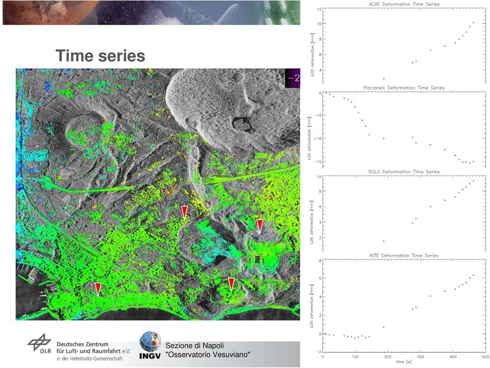
13 Verification and Comparison GPS time series of SOLO and ACAE of acquisition time projected into LOS Good agreement Deformation trend correct Only a few mm difference between GPS (LOS) and SBAS (LOS), likely due to correction data of IPPO Smoothing Projection cont. Slide 13

14 Interpretation Starting from the end of 2004, the Campi Flegrei caldera exhibits an uplift phase where the vertical component of the ground displacement reached +77 mm (November 2004 June 2011) on benchmark 25A InSAR results (12/2009-3/2011) confirm the general uplift of the whole region of approximately 5mm/y Conversely, the south eastern part inside the Solfatara crater shows a different behaviour compared with general trend of the Campi Flegrei area, likely related to soil compaction phenomena (degassing) As a general comment, we must point out that, in the absence of a strong deformation signal affecting the whole area, very local and shallow deformation events mostly prevail Slide 14

15 Outlook & ongoing works X-Band time-series of Campi Flegrei X-Band resolution is key-point for monitoring low deformation-rates of Campi Flegrei TSX data acquisition continues until end of 2011 (for now!) Extension of SBAS processing using new scenes Fast single interferograms in crisis situations possible Getting a grip of horizontal motions Campi Flegrei is a test site in the Supersites initiative The data used here, is available in EOWEB archive Slide 15

16 Thank you! Questions? Slide 16
ERS-ENVISAT ENVISAT deformation time-series analysis: a unique opportunity to investigate long term surface deformation of large areas
 ERS-ENVISAT ENVISAT deformation time-series analysis: a unique opportunity to investigate long term surface deformation of large areas R. Lanari 1, P. Berardino 1, M. Bonano 1,2, F. Casu 1, A. Manconi
TerraSAR-X Interferometry. Michael Eineder, Nico Adam Remote Sensing Technology Institute
 TerraSAR-X Interferometry Michael Eineder, Nico Adam Remote Sensing Technology Institute TerraSAR-X Contribution to Commissioning Phase: verify phase and geometric stability of instrument and SAR processor
Satellites for Terrain Motion Mapping Terrafirma User Workshop Mining. Nico Adam
 Satellites for Terrain Motion Mapping Terrafirma User Workshop Mining Nico Adam Outline SAR / InSAR observation characteristic Sensors TSX, TDX ERS-1, ERS-2 Processing techniques D-InSAR PSI SBAS Acquisition
Monitoring a Changing Environment with Synthetic Aperture Radar. Alaska Satellite Facility National Park Service Don Atwood
 Monitoring a Changing Environment with Synthetic Aperture Radar Don Atwood Alaska Satellite Facility 1 Entering the SAR Age 2 SAR Satellites RADARSAT-1 Launched 1995 by CSA 5.6 cm (C-Band) HH Polarization
PI: Riccardo Lanari (IREA CNR) email:lanari.r@irea.cnr.it
 email:lanari.r@irea.cnr.it") On the exploitation and validation of COSMO-SkyMed interferometric SAR data for digital terrain modelling and surface deformation analysis in extensive urban areas (ID: 1441) Project partners: Istituto
On the exploitation and validation of COSMO-SkyMed interferometric SAR data for digital terrain modelling and surface deformation analysis in extensive urban areas (ID: 1441) Project partners: Istituto
A multi-scale approach to InSAR time series analysis
 A multi-scale approach to InSAR time series analysis M. Simons, E. Hetland, P. Muse, Y. N. Lin & C. DiCaprio U Interferogram stack time A geophysical perspective on deformation tomography Examples: Long
Exploitation of historical satellite SAR archives for mapping and monitoring landslides at regional and local scale
 Exploitation of historical satellite SAR archives for mapping and monitoring landslides at regional and local scale (A. Ferretti (TRE), A. Tamburini (TRE), M. Bianchi (TRE), M. Broccolato (Regione Valle
GPS Precise Point Positioning as a Method to Evaluate Global TanDEM-X Digital Elevation Model
 GPS Precise Point Positioning as a Method to Evaluate Global TanDEM-X Digital Elevation Model 7 th FIG Regional Conference TS 1C Advances in GNSS Positioning and Applications I Volker Schwieger 1, Jürgen
Terrafirma Persistent Scatterer Processing Validation
 Terrafirma Persistent Scatterer Processing Validation Nico Adam (1), Alessandro Parizzi (1), Michael Eineder (1), Michele Crosetto () (1) Remote Sensing Technology Institute () Institute of Geomatics Signal
Radar interferometric techniques and data validation Terrafirma Essen, March 2011. Page 1
 Radar interferometric techniques and data validation Terrafirma Essen, March 2011 Page 1 Agenda Introduction to InSAR technology Different radarinterferometric techniques Validation of InSAR technology
Integration between spaceand ground-based data sets: application on ground deformations measurements
 Integration between spaceand ground-based data sets: application on ground deformations measurements Giuseppe Puglisi Istituto Nazionale di Geofisica e Vulcanologia Sezione di Catania Osservatorio Etneo
Recent Advances in Pixel Localization Accuracy
 Recent Advances in Pixel Localization Accuracy U. Balss, X. Cong, M. Eineder, H. Breit, T. Fritz, B. Schättler Remote Sensing Technology Institute (IMF) German Aerospace Center (DLR) Outline Operational
How To Write A Call To Action For Terrasar-X
 Doc.: TX-PGS-PL-4127 TerraSAR-X Announcement of Opportunity: Utilization of the TerraSAR-X Archive 1 Page: 2 of 11 TABLE OF CONTENTS TERRASAR-X... 1 ANNOUNCEMENT OF OPPORTUNITY: UTILIZATION OF THE TERRASAR-X
A Cloud Computing Approach for Big DInSAR Data Processing
 A Cloud Computing Approach for Big DInSAR Data Processing through the P-SBAS Algorithm Zinno I. 1, Elefante S. 1, Mossucca L. 2, De Luca C. 1,3, Manunta M. 1, Terzo O. 2, Lanari R. 1, Casu F. 1 (1) IREA
SAR Archive and Community Support Activities at UNAVCO
 SAR Archive and Community Support Activities at UNAVCO Scott Baker 1, Chris Crosby 1, Charles Meertens 1, Eric Fielding 2, Gwen Bryson 3, Brian Buechler 3, Jeremy Nicoll 3, Chaitanya Baru 4 1 UNAVCO, Boulder,
Prediction of Storm Surge using Space Data. Susanne Lehner German Aerospace Center
 Prediction of Storm Surge using Space Data Susanne Lehner German Aerospace Center Existing Crisis Information State of the Art of Satellite Crisis Information (ZKI) Mapping after the storm www.zki.de
POTENTIALS OF HIGH RESOLUTION TERRASAR-X IMAGES IN INSAR PROCESSING
 POTENTIALS OF HIGH RESOLUTION TERRASAR-X IMAGES IN INSAR PROCESSING FOR EARTH DEFORMATION AND ENVIRONMENTAL STUDIES Magdalena Niemiec 1 Abstract Accurate determination of topography and surface deformation
Using advanced InSAR techniques as a remote tool for mine site monitoring
 The Southern African Institute of Mining and Metallurgy Slope Stability 2015 D. Colombo and B. MacDonald Using advanced InSAR techniques as a remote tool for mine site monitoring D. Colombo* and B. MacDonald
SAR Measurements of Wind Field, Sea State Topography at Offshore Platforms
 SAR Measurements of Wind Field, Sea State Topography at Offshore Platforms Susanne Lehner DLR, Oberpfaffenhofen Susanne.Lehner@dlr.de Planned NRT Products ENVISAT Wind Sea State OIl Land-Water Line Ships
Comparison of ALOS-PALSAR and TerraSAR-X Data in terms of Detecting Settlements First Results
 ALOS 2008 Symposium, 3-7 November Rhodes, Greece Comparison of ALOS-PALSAR and TerraSAR-X Data in terms of Detecting Settlements First Results Thomas Esch*, Achim Roth*, Michael Thiel, Michael Schmidt*,
TerraSAR-X Applications Guide
 TerraSAR-X Applications Guide Extract: Maritime Monitoring: Oil Spill Detection April 2015 Airbus Defence and Space Geo-Intelligence Programme Line Maritime Monitoring: Oil Spill Detection Issue As the
European Gravity Service for Improved Emergency Management
 European Gravity Service for Improved Emergency Management a new Horizon2020 project to serve the international community and improve the accessibility to gravity field products A. Jäggi 1, M. Weigelt
Case Study Australia. Dr John Dawson A/g Branch Head Geodesy and Seismic Monitoring Geoscience Australia. Chair UN-GGIM-AP WG1 Chair APREF.
 Case Study Australia Dr John Dawson A/g Branch Head Geodesy and Seismic Monitoring Geoscience Australia Chair UN-GGIM-AP WG1 Chair APREF Page 1 Overview 1. Australian height system Australian Height Datum
High Resolution 3D Earth Observation Data Analysis for Safeguards Activities
 High Resolution 3D Earth Observation Data Analysis for Safeguards Activities Pablo d'angelo a1, Cristian Rossi a, Christian Minet a, Michael Eineder a, Michael Flory b, Irmgard Niemeyer c a German Aerospace
TRACKING DATA MESSAGE. PROTOTYPING TEST PLAN Draft #1
 TRACKING DATA MESSAGE PROTOTYPING TEST PLAN Draft #1 16-Apr-2007 Table of Contents 1. Introduction...3 2. Blue Book Promotion Criteria... 3 3. Tracking Data Message (TDM) Testing Goals... 3 4. Test Overview...
Interferometric TOPS Chain Description
 www.dlr.de/hr > SEOM INSARAP INSARAP Workshop December 10, 2014 > Slide 1 SEOM INSARAP: Sentinel-1 InSAR Performance Study with TOPS Data ESA-ESRIN Contract 4000110587/14/I-BG Interferometric TOPS Chain
TerraSAR-X capabilities and constrains for acquisitions over the polar regions. Dana Floricioiu
 TerraSAR-X capabilities and constrains for acquisitions over the polar regions Dana Floricioiu STG IPY SAR Workshop Montreal 5/6 March 2008 TerraSAR-X Features Multi-Mode Imaging StripMap (High-Resolution)
CASE STUDY LANDSLIDE MONITORING
 Introduction Monitoring of terrain movements (unstable slopes, landslides, glaciers, ) is an increasingly important task for today s geotechnical people asked to prevent or forecast natural disaster that
Professional SAR Data Processing
 Professional SAR Data Processing SAR Tutorial at EUSAR 2012 in Nürnberg (Germany) Dr. Thomas Bahr The information contained in this document pertains to software products and services that are subject
DEM products from TerraSAR-X & TanDEM-X. Nora Meyer zu Erpen // 25.01.2011
 DEM products from TerraSAR- & TanDEM- Nora Meyer zu Erpen // 25.01.2011 GEO-Information Services within Astrium and EADS Airbus Eurocopter Cassidian Astrium Turnover 2009: 4.8 billion Staff 2009: 15,000*
RMS - Remote Monitoring System: GPS application on an Harbour Structure
 Ingenieurvermessung 2004 14th International Conference on Engineering Surveying Zürich, 15. 19. März 2004 RMS - Remote Monitoring System: GPS application on an Harbour Structure Luca Manetti GEODEV SA
June 2011. TerraSAR-X-based Flood Mapping Service
 June 2011 TerraSAR-X-based Flood Mapping Service Service TerraSAR-X-based Flood Mapping Product Flood extent map Product specifications Flood mask / water mask Input / output data Summary Content Date
The dynamics of magma chamber refilling at
 Vertical deformation Seismogram Gravity change The dynamics of magma chamber refilling at the Campi Flegrei caldera A. Longo 1, C. Montagna 1, M. Vassalli 2, P. Papale 1, D. Giudice 1, G. Saccorotti 1
Orbital and atmospheric noise in InSAR data inferred from the global ERS1,2 and Envisat SAR data archives
 Category-1 proposal submitted to the European Space Agency Orbital and atmospheric noise in InSAR data inferred from the global ERS1,2 and Envisat SAR data archives Executive Summary We request the online
European Gravity Service for Improved Emergency Management
 European Gravity Service for Improved Emergency Management a new Horizon2020 project to serve the international community and improve the accessibility to gravity field products A. Jäggi 1, M. Weigelt
TerraSAR X and TanDEM X satellite missions update & other activities Dana Floricioiu German Aerospace Center (DLR), Remote Sensing Technology
, Remote Sensing Technology") TerraSAR X and TanDEM X satellite missions update & other activities Dana Floricioiu German Aerospace Center (DLR), Remote Sensing Technology Institute, Oberpfaffenhofen, Germany PSTG 2 12 14 June 2012
TerraSAR X and TanDEM X satellite missions update & other activities Dana Floricioiu German Aerospace Center (DLR), Remote Sensing Technology Institute, Oberpfaffenhofen, Germany PSTG 2 12 14 June 2012
PROJECT TITLE. ACTIVITY REPORT 2nd YEAR
 PROJECT TITLE CHEMICAL AND ISOTOPIC CHARACTERISTICS OF GASES AND GROUNDWATERS AT VESUVIO, CAMPI FLEGREI, ISCHIA AND VULCANO: EVALUATION OF THE VOLCANIC RISK Scientific Coordinator Name-Position: Stanzione
Dawn - Overview, Science Objectives, Mission Progress. Hap McSween For PI Chris Russell
 Dawn - Overview, Science Objectives, Mission Progress Hap McSween For PI Chris Russell Presentation to Decadal Survey Primitive Bodies Panel, Washington, DC, Sep 2009 Spacecraft configuration, assembly
FROM DRAWING ANTICLINE AXES TO 3D MODELLING OF SEISMOGENIC SOURCES: EVOLUTION OF SEISMOTECTONIC MAPPING IN THE PO PLAIN
 FROM DRAWING ANTICLINE AXES TO 3D MODELLING OF SEISMOGENIC SOURCES: EVOLUTION OF SEISMOTECTONIC MAPPING IN THE PO PLAIN Burrato P.*, Maesano F. E. *, D Ambrogi C.**, Toscani G., Valensise G.* (*) INGV,
CO 2 storage science development and application in Italy
 CO 2 storage science development and application in Italy Salvatore Lombardi Carbon Sequestration Leadership Forum, 16-19 April 2013 Rome, Italy Objectives Site selection and characterization Acquisition
Doctoral degree scholarship. in aeronautics and space travel technology
 Doctoral degree scholarship in aeronautics and space travel technology Scholarship program Munich Aerospace grants scholarships to support young scientists in their doctoral studies. The scholarships are
Data in seismology: networks, instruments, current problems
 Data in seismology: networks, instruments, current problems Seismic networks, data centres, instruments Seismic Observables and their interrelations Seismic data acquisition parameters (sampling rates,
Focus Earth The Velingara Circular Structure A meteorite impact crater?
 Focus Earth The Velingara Circular Structure A meteorite impact crater? S. Wade Institut des Sciences de la Terre, Faculté des Sciences et Techniques, Université Cheikh Anta Diop, Dakar-Fann, Sénégal M.
The April 2007 eruption at Piton de la Fournaise, Réunion Island, imaged with ENVISAT-ASAR and ALOS-PALSAR data
 The April 27 eruption at Piton de la Fournaise, Réunion Island, imaged with ENVISAT-ASAR and A-PALSAR data A. Augier (1), J. L. Froger (1), V. Cayol (1) (1) Laboratoire Magmas et Volcans, Clermont Ferrand
2053-24. Advanced Workshop on Evaluating, Monitoring and Communicating Volcanic and Seismic Hazards in East Africa.
 2053-24 Advanced Workshop on Evaluating, Monitoring and Communicating Volcanic and Seismic Hazards in East Africa 17-28 August 2009 Emergency management in volcanic crisis: Italian cases Vittorio Bosi
Blender 3D Animation
 Bachelor Maths/Physics/Computer Science University Paris-Sud Digital Imaging Course Blender 3D Animation Christian Jacquemin Introduction to Computer Animation Animation Basics animation consists in changing
A trip in Campania Region through the hellenic tradition of. Four Elements. Naples, where AIR, FIRE, EARTH and WATER coexist harmonically
 A trip in Campania Region through the hellenic tradition of Four Elements Naples, where AIR, FIRE, EARTH and WATER coexist harmonically FIRE fire to destroy, fire to enchant POMPEII The Unesco World Heritage
AUTOMATIC INSAR SYSTEMATIC PROCESSING AND WEB BASED TOOL FOR EFFICIENT DATA MINING: APPLICATION TO VOLCANO MONITORING IN AFRICA
 AUTOMATIC INSAR SYSTEMATIC PROCESSING AND WEB BASED TOOL FOR EFFICIENT DATA MINING: APPLICATION TO VOLCANO MONITORING IN AFRICA N. d Oreye (1), and G. Celli (1) (1) National Museum of Natural History,
DIFFERENTIAL INSAR MONITORING OF THE LAMPUR SIDOARJO MUD VOLCANO (JAVA, INDONESIA) USING ALOS PALSAR IMAGERY
 USING ALOS PALSAR IMAGERY") DIFFERENTIAL INSAR MONITORING OF THE LAMPUR SIDOARJO MUD VOLCANO (JAVA, INDONESIA) USING ALOS PALSAR IMAGERY Adam Thomas (1), Rachel Holley (1), Richard Burren (1), Chris Meikle (2), David Shilston (2)
DIFFERENTIAL INSAR MONITORING OF THE LAMPUR SIDOARJO MUD VOLCANO (JAVA, INDONESIA) USING ALOS PALSAR IMAGERY Adam Thomas (1), Rachel Holley (1), Richard Burren (1), Chris Meikle (2), David Shilston (2)
The DLR Multi Mission EO Ground Segment
 The DLR Multi Mission EO Ground Segment Payload Ground Segment Erhard Diedrich Remote Sensing Workshop Mexico 22-24 April 2008 DLR Ground Segment for Earth Observation: Servicing GMES, national and commercial
Behavioral Animation Simulation of Flocking Birds
 Behavioral Animation Simulation of Flocking Birds Autonomous characters determine their actions Simulating the paths of individuals in: flocks of birds, schools of fish, herds of animals crowd scenes 1.
German Antarctic Receiving Station GARS O Higgins: Remote sensing as core for a broader range of activities
 DLR.de Chart 1 > Kathrin Hoeppner > EU-Chile-Workshop > November 28-29, 2013 > Punta Arenas, Chile German Antarctic Receiving Station GARS O Higgins: Remote sensing as core for a broader range of activities
TerraSAR-X Image Product Guide. Basic and Enhanced Radar Satellite Imagery. Airbus Defence and Space Geo-Intelligence Programme Line
 TerraSAR-X Image Product Guide Geo-Intelligence Programme Line 1 Introduction TerraSAR-X and TanDEM-X are commercial German Synthetic Aperture Radar (SAR) Earth observation satellites, which were launched
Interferometric Synthetic Aperture Radar (SAR) Missions Employing Formation Flying
 Missions Employing Formation Flying") INVITED PAPER Interferometric Synthetic Aperture Radar (SAR) Missions Employing Formation Flying A German Earth satellite system is designed to produce data on forest structure, biomass, tectonic shifts
INVITED PAPER Interferometric Synthetic Aperture Radar (SAR) Missions Employing Formation Flying A German Earth satellite system is designed to produce data on forest structure, biomass, tectonic shifts
Remote Sensing Applications in Support of Sustainable Development and Disaster Management by DLR Current Activities
 Remote Sensing Applications in Support of Sustainable Development and Disaster Management by DLR Current Activities Dr. Günter Strunz German Aerospace Center (DLR) German Remote Sensing Data Center 43rd
Persistent Scatterer Interferometry and Cosmo-SkyMed data in the Piano Straordianario di Telerilevamento Ambientale (PST-A) Salvatore Costabile
 Salvatore Costabile") Persistent Scatterer Interferometry and Cosmo-SkyMed data in the Piano Straordianario di Telerilevamento Ambientale (PST-A) Salvatore Costabile E-GEOS Conference 2012 23-24 May, Rome (Italy) Summary PST-A:
Persistent Scatterer Interferometry and Cosmo-SkyMed data in the Piano Straordianario di Telerilevamento Ambientale (PST-A) Salvatore Costabile E-GEOS Conference 2012 23-24 May, Rome (Italy) Summary PST-A:
Physics: Principles and Applications, 6e Giancoli Chapter 2 Describing Motion: Kinematics in One Dimension
 Physics: Principles and Applications, 6e Giancoli Chapter 2 Describing Motion: Kinematics in One Dimension Conceptual Questions 1) Suppose that an object travels from one point in space to another. Make
GEOPHYSICAL EFFECTS ON SITE DISPLACEMENTS FOR PERMANENT GPS TRACKING STATIONS IN TAIWAN
 GEOPHYSICAL EFFECTS ON SITE DISPLACEMENTS FOR PERMANENT GPS TRACKING STATIONS IN TAIWAN C. C. Chang Department of Surveying and Mapping Engineering Chung Cheng Institute of Technology Tahsi, Taoyuan 335,
Deutsches Fernerkundungsdatenzentrum Nationales Bodensegment Neustrelitz. Holger Maass. Storagetechnology 2008 4.-6. Juni 2008, Fleesensee
 Deutsches Fernerkundungsdatenzentrum Nationales Bodensegment Neustrelitz Holger Maass Storagetechnology 2008 4.-6. Juni 2008, Fleesensee German Remote Sensing Data Center ( DFD ) with 2 locations in Germany
Evolving a new Geodetic Positioning Framework: An Australian Perspective
 Evolving a new Geodetic Positioning Framework: An Australian Perspective G. Johnston, J. Dawson Outline Introduction Precise Positioning National Geospatial Reference Systems Asia Pacific Reference Frame
TerraSAR-X Products Tips and Tricks
 TerraSAR-X Products Tips and Tricks Thomas Fritz Helko Breit Michael Eineder (L1b Annotation, Geometry, Radiometry) (Processing, Spectral Properties) (InSAR-Processing incl. Spotlight) DLR Remote Sensing
B) 286 m C) 325 m D) 367 m Answer: B
 286 m C) 325 m D) 367 m Answer: B") Practice Midterm 1 1) When a parachutist jumps from an airplane, he eventually reaches a constant speed, called the terminal velocity. This means that A) the acceleration is equal to g. B) the force of
Practice Midterm 1 1) When a parachutist jumps from an airplane, he eventually reaches a constant speed, called the terminal velocity. This means that A) the acceleration is equal to g. B) the force of
Dipl. Ing. Falk Pätzold Technische Universität Braunschweig, Institut für Flugführung February 21 st 2014
 1/14 Results of Flight Performance Determination of the Lak 17a FES (S5 3117) using the comparison flight method in Aalen Heidenheim Elchingen, August 20th and 21st 2012 Dipl. Ing. Falk Pätzold Technische
Traffic Monitoring Systems. Technology and sensors
 Traffic Monitoring Systems Technology and sensors Technology Inductive loops Cameras Lidar/Ladar and laser Radar GPS etc Inductive loops Inductive loops signals Inductive loop sensor The inductance signal
Application of TanDEM-X interferometry in volcano monitoring using Merapi, Indonesia and Volcán de Colima, Mexico as test sites
 , Malte Westerhaus, Bernhard Heck Application of TanDEM-X interferometry in volcano monitoring using Merapi, Indonesia and Volcán de Colima, Mexico as test sites, Department of Civil Engineering, Geo and
sonobot autonomous hydrographic survey vehicle product information guide
 sonobot autonomous hydrographic survey vehicle product information guide EvoLogics Sonobot an autonomous unmanned surface vehicle for hydrographic surveys High Precision Differential GPS for high-accuracy
DESCW: PC Software Supporting Remote Sensing Data
 r bulletin 97 march 1999 DESCW: PC Software Supporting Remote Sensing Data S. D Elia Earth Remote Sensing Exploitation Division, ESA Directorate for Application Programmes, ESRIN, Frascati, Italy R. Biasutti
Estimating Firn Emissivity, from 1994 to1998, at the Ski Hi Automatic Weather Station on the West Antarctic Ice Sheet Using Passive Microwave Data
 Estimating Firn Emissivity, from 1994 to1998, at the Ski Hi Automatic Weather Station on the West Antarctic Ice Sheet Using Passive Microwave Data Mentor: Dr. Malcolm LeCompte Elizabeth City State University
The RapidEye optical satellite family for high resolution imagery
 'Photogrammetric Week 01' D. Fritsch & R. Spiller, Eds. Wichmann Verlag, Heidelberg 2001. Scherer, Krischke 139 The RapidEye optical satellite family for high resolution imagery STEFAN SCHERER and MANFRED
Jun NISHIJIMA, Daisuke OKA, Satoru HIGUCHI Yasuhiro FUJIMITSU, Junichi TAKAYAMA and Naoto HIRAGA
 Proceedings World Geothermal Congress 2015 Melbourne, Australia, 19-25 April 2015 Repeat Microgravity Measurements Using Absolute and Relative Gravimeters for Geothermal Reservoir Monitoring in Ogiri Geothermal
Integrated surveying system for landslide monitoring, Valoria Landslide (Appennines of Modena, Italy)
") Integrated surveying system for landslide monitoring, Valoria Landslide (Appennines of Modena, Italy) Eleonora BERTACCHINI, Andrea CAPITANI, Alessandro CAPRA, Cristina CASTAGNETTI, Alessandro CORSINI,
Integrated surveying system for landslide monitoring, Valoria Landslide (Appennines of Modena, Italy) Eleonora BERTACCHINI, Andrea CAPITANI, Alessandro CAPRA, Cristina CASTAGNETTI, Alessandro CORSINI,
REGIUS History. Touch REGIUS110. REGIUS170 ImagePilot REGIUS150 REGIUS330 CS-1
 Konica Minolta has been a CR technology leader since 1996, consistently designing, developing, and delivering innovative solutions. The REGIUS Σ represents the sum of this experience. REGIUS Σ delivers
AS COMPETITION PAPER 2008
 AS COMPETITION PAPER 28 Name School Town & County Total Mark/5 Time Allowed: One hour Attempt as many questions as you can. Write your answers on this question paper. Marks allocated for each question
Italy - Porto Tolle: storage in offshore saline aquifer
 Italy - Porto Tolle: storage in offshore saline aquifer Monia Politi Enel - Engineering & Innovation Division - Research CO2GeoNet Open Forum 9-11 May 2011, San Servolo Island, Venice High level overview
EO Information Services in support of Satellite Tools for Building Flood Defence Systems in Guyana
 EO Information Services in support of Satellite Tools for Building Flood Defence Systems in Guyana F. N. Koudogbo and A. Arnaud Altamira Information I. Bauwens, H. Tambuyzer Eurosense Date : 21 February
A System for Capturing High Resolution Images
 A System for Capturing High Resolution Images G.Voyatzis, G.Angelopoulos, A.Bors and I.Pitas Department of Informatics University of Thessaloniki BOX 451, 54006 Thessaloniki GREECE e-mail: pitas@zeus.csd.auth.gr
Acoustic GHz-Microscopy: Potential, Challenges and Applications
 Acoustic GHz-Microscopy: Potential, Challenges and Applications A Joint Development of PVA TePLa Analytical Systems GmbH and Fraunhofer IWM-Halle Dr. Sebastian Brand (Ph.D.) Fraunhofer CAM Fraunhofer Institute
Keywords: Torque, calibration, uncertainty, torque tools, torque testers. Contents
 Measurement uncertainty in torque calibration Luca G. Bochese, ASQ CQE, CRE (Boch - Milano), info@boch.net, www.boch.net Dr. A. Bochese ( Feanor - Tallinn), info@feanor.com, www.feanor.com Keywords: Torque,

GNSS permanent stations as the part of integrated geodetic system in Estonia
 GNSS permanent stations as the part of integrated geodetic system in Estonia Karin Kollo (MSc) Department of Geodesy Estonian Land Board United Nations/Croatia Workshop on the applications of Global Navigation
CEEN 162 - Geotechnical Engineering Laboratory Session 7 - Direct Shear and Unconfined Compression Tests
 PURPOSE: The parameters of the shear strength relationship provide a means of evaluating the load carrying capacity of soils, stability of slopes, and pile capacity. The direct shear test is one of the
Brian D. Conway Hydrologist/Supervisor Geophysics-Surveying Unit
 Arizona Department of Water Resources Land Subsidence Monitoring Program Using Interferometric Synthetic Aperture Radar (InSAR) in Cochise County, Southeastern Arizona Brian D. Conway Hydrologist/Supervisor
Image courtesy of the Canadian Center for Remote Sensing
 ADWR s Land Subsidence Monitoring Program Interferometric Synthetic Aperture Radar (InSAR) Brian D. Conway Hydrology Division Geophysics/Surveying Unit Image courtesy of the Canadian Center for Remote
Geological hazards and monitoring activities at the Azores archipelago
 Geological hazards and monitoring activities at the Azores archipelago Teresa Ferreira (1,2), João Gaspar (1,2), Gabriela Queiroz (1,2) (1) CVARG (Centre for Volcanology and Geological Risks Assessment)
A tiered reconnaissance approach toward flood monitoring utilising multi-source radar and optical data
 5 th International Workshop on Remote Sensing for Disaster Response A tiered reconnaissance approach toward flood monitoring utilising multi-source radar and optical data Anneley McMillan Dr. Beverley
Cardius. XPO Series. Cardius 3 XPO
 Cardius XPO Series Cardius 3 XPO Three imaging systems, all of which provide outstanding image quality, superior efficiency, and increased patient comfort. Cardius 2 XPO Includes the standard features
A PHOTOGRAMMETRIC APPRAOCH FOR AUTOMATIC TRAFFIC ASSESSMENT USING CONVENTIONAL CCTV CAMERA
 A PHOTOGRAMMETRIC APPRAOCH FOR AUTOMATIC TRAFFIC ASSESSMENT USING CONVENTIONAL CCTV CAMERA N. Zarrinpanjeh a, F. Dadrassjavan b, H. Fattahi c * a Islamic Azad University of Qazvin - nzarrin@qiau.ac.ir
manufacturer of seismic borehole equipment sales rentals field service
 manufacturer of seismic borehole equipment sales rentals field service the company Geotomographie provides complete solutions for borehole and near-surface seismic surveys to geophysical, engineering and
HAZUBA. HAZUBA AG Rainstrasse 17 4528 Zuchwil T 032 685 88 88 F 032 685 88 89 info@hazuba.ch 06/14
 06/14 NEW BNC 002 BK 29.- CHF This Braun travel alarm clock measures 56mm x 56mm x 31mm and is available in two colours. It has an easy to read dial layout, crescendo alarm and a quiet German precision
Graphical displays are generally of two types: vector displays and raster displays. Vector displays
 Display technology Graphical displays are generally of two types: vector displays and raster displays. Vector displays Vector displays generally display lines, specified by their endpoints. Vector display
The Dynamic Crust 2) EVIDENCE FOR CRUSTAL MOVEMENT
 EVIDENCE FOR CRUSTAL MOVEMENT") The Dynamic Crust 1) Virtually everything you need to know about the interior of the earth can be found on page 10 of your reference tables. Take the time to become familiar with page 10 and everything
The Dynamic Crust 1) Virtually everything you need to know about the interior of the earth can be found on page 10 of your reference tables. Take the time to become familiar with page 10 and everything
GOM Optical Measuring Techniques. Deformation Systems and Applications
 GOM Optical Measuring Techniques Deformation Systems and Applications ARGUS Forming Analysis ARGUS Deformation analysis in sheet metal and forming industry Forming Characteristics of Sheet Metals Material
SINKING CITIES IN INDONESIA: SPACE-GEODETIC EVIDENCE OF THE RATES AND SPATIAL DISTRIBUTION OF LAND SUBSIDENCE
 SINKING CITIES IN INDONESIA: SPACE-GEODETIC EVIDENCE OF THE RATES AND SPATIAL DISTRIBUTION OF LAND SUBSIDENCE Estelle Chaussard (1), Falk Amelung (2), Hasanuddin Z. Abidin (3) (1) School of Marine and
F1 Fuel Tank Surging; Model Validation
 F1 Fuel Tank Surging; Model Validation Luca Bottazzi and Giorgio Rossetti Ferrari F1 team, Maranello, Italy SYNOPSIS A Formula One (F1) car can carry more than 80 kg of fuel in its tank. This has a big
THE NEED TO IMPLEMENT CONSTRUCTION DEFORMATION SPATIAL MONITORING SYSTEMS IN ROMANIA
 THE NEED TO IMPLEMENT CONSTRUCTION DEFORMATION SPATIAL MONITORING SYSTEMS IN ROMANIA Cristian ONU, Lecturer PhD. Eng., Technical University Gheorghe Asachi of Iasi, Romania, e-mail: cristi_onu@yahoo.com
Getec. The Geo Structural Monitoring Experts
 Getec The Geo Structural Monitoring Experts Getec Getec specialises in providing instrumentation and monitoring solutions for a wide range of applications. We focus on producing reliable, repeatable data
Publications in journals
 Publications in journals Capuano, P., Russo, G., and Scarpa, R., 2013, P-wave velocity and density structure beneath Mt. Vesuvius: a magma body in the upper edifice?: Ann. Geophys., 56, 1-13, doi: 10.4401/ag-6443
German Earth Observation Systems and Programs Capacities for nation building
 German Earth Observation Systems and Programs Capacities for nation building German Aerospace Center, DLR, Earth Observation Center, EOC German Remote Sensing Data Center, DFD Gunter Schreier Deputy Director
Local monitoring by low cost devices and free and open sources softwares
 Local monitoring by low cost devices and free and open sources softwares Abstract Ludovico Biagi, Florin-Catalin Grec, Marco Negretti, Maria Grazia Visconti Politecnico di Milano, DICA@ComoCampus The purpose
ABB Robotics, June 2014. IRB 1200 Overview. ABB Group August 21, 2014 Slide 1
 ABB Robotics, June 2014 IRB 1200 Overview August 21, 2014 Slide 1 Overview Differentiated value proposition Have you ever wanted to make your machines 15% smaller and 10% faster? ABB s new IRB 1200 allows