Eastern Michigan University & ESRI Michigan s K-12 GIS License Program
|
|
|
- Mercy Nicholson
- 8 years ago
- Views:
Transcription
1 Eastern Michigan University & ESRI Michigan s K-12 GIS License Program Presented by: Mike Dueweke EMU/ESRI K-12 GIS License Administrator mdueweke@emich.edu

2 PRESENTATION OUTLINE What is the EMU/ESRI K-12 License Program? Why use GIS in K-12 education? Who benefits from the program? What are the benefits of the program? How do I apply for benefits? Website Overview I m not an Educator; Can I get involved? Join the Geospatial Revolution!

3 WHAT IS THE EMU/ESRI K-12 LICENSE PROGRAM? Collaboration between EMU s College of Education, Michigan Virtual University and ESRI. Administrative, development and technical support services provided by the Institute for Geospatial Research & Education and the Department of Geography & Geology through the College of Arts & Sciences. Provides access to free software, free training and free limited technical support to all K-12 schools. Use for teaching, learning, research, and administrative uses throughout the entire state of Michigan.

4 WHY USE GIS IN K-12 EDUCATION? SOCIAL STUDIES CONTENT EXPECTATION GRADES 6-12

5 WHO BENEFITS FROM THE K-12 PROGRAM? SCHOOLS & TEACHERS - School Campus License for instructional use that includes all instructional computers on the school campus as well as teachers' personal computers. ADMINISTRATORS & DISTRICTS - Administrative Use License for use in the operation/management of an educational institution. It allows administrative offices to perform functions such as demographic planning, school transportation, and facilities management. STUDENTS & PARENTS - Student License for use by qualified students and educators at home or on a personal computer. This license is held by an individual person rather than the educational institution. SCOPE - Available to all public, private and parochial school systems including home schooled and after school educational programs (i.e. 4-H, Boy & Girl Scouts, Not-for- Profits or Corporations working with students).

6 WHAT ARE THE BENEFITS OF THE PROGRAM? FREE SOFTWARE ArcGIS 10.1 for Desktop (Basic, Standard & Advanced) ArcGIS Server (Advanced Enterprise, Advanced Workgroup, ArcGIS Image Server, ArcGIS Tracking Server, ArcIMS) Arc Logistics Desktop (routing & scheduling) ESRI City Engine (3D modeling) ArcGIS Online (GIS in the Cloud) FREE EXTENSIONS 3D Analyst, ArcGIS Data Reviewer, ArcGIS for Maritime, ArcScan, COGO, Data Interoperability, ESRI Aeronautical Solution, ESRI Defense Mapping, ESRI Production Mapping, Geostatistical Analyst, Mapplex, Network Analyst, publisher, Schematics, Apatial Analyst, Tracking Analyst, Workflow Manager


7 WHAT ARE THE BENEFITS OF THE PROGRAM? FREE WEB TRAINING

8 HOW DO I APPLY FOR BENEFITS? GETTING STARTED

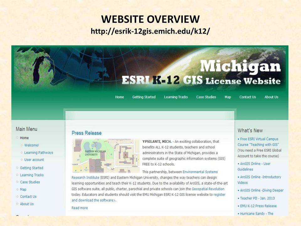
9 WEBSITE OVERVIEW
10 HOW CAN I BECOME INVOLVED? Become a GeoMentor GIS professionals understand the power of GIS. Your work affects your community and the world. Volunteer and share your knowledge with schools, teachers, informal youth groups and young people in your community. Help educators and students develop skills in geographic thinking. Help get support problems solved, and provide youth with powerful new knowledge that fosters long-term skills. Share experience with those around you and help them learn about the power of GIS.

11 SO, DO YOU MEAN YOU WANT ME TO TEACH ArcGIS DESKTOP? ARE YOU CRAZY!

12 NO! LETS USE ArcGIS ONLINE INSTEAD IT S GIS IN THE CLOUD! Content-based GIS Management System - Software delivered as a service; nothing to install or setup; easy and intuitive workspace ; publish maps as feature or tiled map services. Ready to Use Content Basemaps, demographic maps, image services and data. Easily Add Data - Add your data, create mashups, add pop-ups. Make Maps directly in Excel ESRI maps for Office add-in. Security and Data Ownership control access with multiple layers of security. THE BEST TOOL FOR K-12 TEACHERS

13 ArcGIS ONLINE


14 Teaching with GIS: Introduction to Using GIS in the Classroom

15 INTRODUCTION TO THE GEOSPATIAL REVOLUTION

STATE OF NEW YORK PRICELIST August 2015 Net Price NY
 CLIN Number Esri Part Number Section Product Description Price 1 ArcGIS for Desktop Concurrent Use Licenses STATE OF NEW YORK PRICELIST August 2015 Net Price NY GIS0001 52382 ArcGIS for Desktop Advanced
ArcGIS for. Intelligence
 ArcGIS for ArcGIS for solutions.arcgis.com/intelligence Copyright 2015 Esri. All rights reserved. 146660 DUAL3M7/15rk Briefing Book ArcGIS for Briefing Book ArcGIS Web Application ArcGIS for Create and
ArcGIS Viewer for Silverlight An Introduction
 Esri International User Conference San Diego, California Technical Workshops July 26, 2012 ArcGIS Viewer for Silverlight An Introduction Rich Zwaap Agenda Background Product overview Getting started and
Embracing ArcGIS for Local Government. Robert Parsons Delaware County, Ohio Auditor s Office Steve Koenig Bruce Harris & Associates
 Embracing ArcGIS for Local Government Robert Parsons Delaware County, Ohio Auditor s Office Steve Koenig Bruce Harris & Associates Background Project began in April 2013 At that time ArcIMS 9.2 was the
ArcGIS Pro. James Tedrick, Esri
 ArcGIS Pro James Tedrick, Esri What you already know Why ArcGIS PRO? Vision The next generation ArcGIS desktop application for the GIS community who need a clean and comprehensive user experience which
Managing Bathymetry in the Cloud with GIS
 Esri Maritime Professional Services GEBCO Science Day Tuesday, October 4, 2011 Managing Bathymetry in the Cloud with GIS Timothy Kearns & Beata Van Esch Overview The challenges of bathymetry in GIS - What
About As. In a team with the best. ESRI Bulgaria is the exclusive distributor of Esri Inc. for Bulgaria. Esri Inc.
 About As ESRI Bulgaria is an IT company, leader in the field of Geographic Information Systems (GIS) on the Bulgarian market. Offering the most advanced high-tech products, solutions and services, ESRI
A Personal Cloud Server System for hosting Crowdsourced flood data
 A Personal Cloud Server System for hosting Crowdsourced flood data Contextualized with a case study on a Flood Points Map on the City of West Hollywood, CA Contextualized by Sam Perez Methodology Shapefile
 Mesa Community College Geographic Information Systems Technician Certificate (GISTC) Karen Blevins Faculty / GIS Program Coordinator Overview Program in brief Program development Original Program Current
ArcGIS 10.1 Web Apps and APIs. John Hasthorpe & Kai Hübner
 ArcGIS 10.1 Web Apps and APIs John Hasthorpe & Kai Hübner Overview Options for leveraging ArcGIS Server using Esri s Web APIs Alternatives to the Web ADF application builder (Gone in 10.1) When and how
Implementing ArcGIS for SharePoint Habitat for Humanity of Omaha April, 2013
 Ingenuity Innovation Integrity Implementing ArcGIS for SharePoint Habitat for Humanity of Omaha April, 2013 1851 Alexander Bell Drive Suite 350 Reston, VA 20191 703.463.2059 800.483.2434 www.vistronix.com
Mapping Mashup/Data Integration Development Resources Teaching with Google Earth and Google Ocean Stone Lab August 13, 2010
 Mapping Mashup/Data Integration Development Resources Teaching with Google Earth and Google Ocean Stone Lab August 13, 2010 David Hart GIS Specialist University of Wisconsin Sea Grant Institute Virtual
ArcGIS. Server. A Complete and Integrated Server GIS
 ArcGIS Server A Complete and Integrated Server GIS ArcGIS Server A Complete and Integrated Server GIS ArcGIS Server enables you to distribute maps, models, and tools to others within your organization
Create and share a map with GIScloud.com
 Create and share a map with GIScloud.com GIS Cloud is a web based Geographic Information System powered by Cloud Computing and with the full power of desktop GIS. It allows users to create and access your
Cloud+ Experiences with New Technologies bringing GIS to the World. Eamon Walsh CTO, espatial
 Cloud+ Experiences with New Technologies bringing GIS to the World Eamon Walsh CTO, espatial Agenda 1. Introduction to Cloud Computing for GIS 2. Examples 3. The Next Step Multi-Tenancy 4. Business Impact
Conservation Workshop ArcGIS Explorer
 Conservation Workshop ArcGIS Explorer Bern Szukalski bszukalski@esri.com Topics for this session Introduction Overview of features Using ArcGIS Explorer effectively New features & capabilities Customization
Esri Maps for Office, SharePoint & Dynamics CRM. Tony Howser Sentha Sivabalan Scott Ball
 Esri Maps for Office, SharePoint & Dynamics CRM Tony Howser Sentha Sivabalan Scott Ball Agenda Location Analytics Esri Maps for - SharePoint - Office - Dynamics CRM Pricing Road Map Q & A Evolving the
Five Steps to Better Performance
 Effective Web maps have a specific focus and are designed so users can interact with them to accomplish meaningful tasks. Five Steps to Better Performance Sample methodology for creating a great Web map
Configuring and Extending ArcGIS Solutions Web Applications
 Esri Developer Summit March 8 11, 2016 Palm Springs, CA Configuring and Extending ArcGIS Solutions Web Applications Allison Muise & Mike Tschudi ArcGIS Solutions? ArcGIS as a Platform Simple, Open, and
ArcGIS Web Mapping. Sam Berg, esri sberg@esri.com
 ArcGIS Web Mapping Sam Berg, esri sberg@esri.com Agenda ArcGIS and WebMaps The APIs ArcGIS for Flex Viewer ArcGIS for Silverlight Builder ArcGIS for Sharepoint ArcGIS Application Templates ArcGIS Runtime
Editing Strategies for Enterprise Geodatabase
 Federal GIS Conference February 9 10, 2015 Washington, DC Editing Strategies for Enterprise Geodatabase Ty Fabling Esri Solution Engineer A Complete Platform Enabling GIS Everywhere Desktop Web Device
Hi-Tech Recruiting & Staffing. AISD All Staff Virtual Convocation
 0 Hi-Tech Recruiting & Staffing Strategic Planning Mission & Vision Goals Applicant Tracking System Recruiting AISD All Staff Virtual Convocation Staffing Social Media & Internet Virtual Interviews Custom
Quick Start Guide to. ArcGISSM. Online
 Quick Start Guide to ArcGISSM Online ArcGIS Online Quick Start Guide ArcGIS SM Online is a cloud-based mapping platform for organizations. Users get access to dynamic, authoritative content to create,
What is GIS. What is GIS? University of Tsukuba. What do you image of GIS? Copyright(C) ESRI Japan Corporation. All rights reserved.
 ESRI Japan Corporation. All rights reserved.") What is GIS University of Tsukuba Graduate School of Life and Environmental Science April 21 st, 2011 What is GIS? What do you image of GIS? Gas Insulated Switch Groupe Interventional Speciale Geographic
What is GIS University of Tsukuba Graduate School of Life and Environmental Science April 21 st, 2011 What is GIS? What do you image of GIS? Gas Insulated Switch Groupe Interventional Speciale Geographic
Fall 2015 GES 4120/5120 Internet GIS
 Fall 2015 GES 4120/5120 Internet GIS Instructor: Dr. Somayeh Dodge Assistant Professor Department of Geography & Environmental Studies website: http://www.uccs.edu/~sdodge/ e-mail: sdodge3@uccs.edu Office:
Portal for ArcGIS. Satish Sankaran Robert Kircher
 Portal for ArcGIS Satish Sankaran Robert Kircher ArcGIS A Complete GIS Data Management Planning & Analysis Field Mobility Operational Awareness Constituent Engagement End to End Integration Collect, Organize,
Intro to Web App Builder. Mark Scott, Solutions Engineer, Esri County Government Team mscott@esri.com
 Intro to Web App Builder Mark Scott, Solutions Engineer, Esri County Government Team mscott@esri.com The ArcGIS Platform enables Web GIS Enabling GIS Everywhere Desktop Web Device Simple Integrated Open
http://www.esri.com/bia
 ArcGIS for Tribal Transportation Management David Gadsden Federal Account Manager dgadsden@esri.com d d 1 David Gadsden GIS Background UW Geography (1995) Peace Corps Tanzania Environmental Social Science
How To Use Gis
 Welcome Understanding Purpose Creating Relationships You A Global Community of GIS Professionals Changing the World Together Applying Geography Everywhere Your WORK Showcasing Your Web Apps Vision Applying
Principal Selection Process: Managing the Talent Electronically Dr. Meria Carstarphen, Superintendent
 Principal Selection Process: Managing the Talent Electronically Dr. Meria Carstarphen, Superintendent 0 1 Principal Selection Process: Managing the Talent Electronically Strategic Planning Mission, Vision,
Leading Edge Technology Initiative. Virtualizing the GIS Application Desktop through Remote Connect Technology
 Leading Edge Technology Initiative Virtualizing the GIS Application Desktop through Remote Connect Technology Vince DiNoto Dean of System Initiatives Kentucky Community and Technical College System Currently,
Mapping Mashup/Data Integration Development Resources
 Mapping Mashup/Data Integration Development Resources David Hart GIS Specialist University of Wisconsin Sea Grant Institute October 6, 2008 Virtual Globes A virtual globe is a 3D software model or representation
How to Setup and Manage Spatial Assets with ArcGIS Online for a Mobile Workforce
 How to Setup and Manage Spatial Assets with ArcGIS Online for a Mobile Workforce W A U R I S A 2 0 1 4 Presented By Engineer Technician II Pierce County Public Works and Utilities Road Operations Division
Mobile Solutions in ArcGIS. Justin Fan
 Mobile Solutions in ArcGIS Justin Fan Agenda Introducing Mobile GIS Esri Mobile GIS solutions Selecting the right Mobile GIS solution Resources Q&A Introducing Mobile GIS What is Mobile GIS? Extends the
Welcome to Esri's Software Export Control Classification Number (ECCN) Matrix
 Matrix") Welcome to Esri's Software Export Control Classification Number (ECCN) Matrix Updated September 30, 2015 This portion of the Esri web site is to provide information regarding the export control classification
Welcome to Esri's Software Export Control Classification Number (ECCN) Matrix Updated September 30, 2015 This portion of the Esri web site is to provide information regarding the export control classification
Step 1 Preparation and Planning
 Its daunting starting any GIS Web or Mobile project. Where does one begin? This 3 step guide should help you get past your project inertia and start things moving rapidly forward. Step 1 Preparation and
Microsoft and Esri - Together in Singapore
 icrosoft Esri >> Giving you the power to think and plan geographically Contents partners since 1986 02 Increase productivity 04 inspire Creativity 06 Organize Information 08 Go Mobile 10 ENCouraGE Awareness
Enhancing Asset Management with a GIS Program. Lori A. Burkert, P.G. lburkert@entecheng.com 610-373-6667
 Enhancing Asset Management with a GIS Program Lori A. Burkert, P.G. lburkert@entecheng.com 610-373-6667 presentation overview Definitions Its all about your assets Components of a GIS Why use GIS for asset
Deploying ArcGIS for Server Using Managed Services
 Deploying ArcGIS for Server Using Managed Services Andrew Sakowicz Erin Ross Sridhar Karra Agenda Introduction Program Overview - Overview - Methodology - Tools Customer Deployments - Architecture and
Mobile GIS Guide. About The Author. Getting your mobile GIS project off the ground
 About The Author Matt Sheehan is a mobile GIS pioneer. He and his staff at WebMapSolutions have been providing clients with mobile GIS solutions since the earliest days of smartphones and tablets. We live
Developing Web Apps with ArcGIS API for JavaScript TM. Student Edition
 Developing Web Apps with ArcGIS API for JavaScript TM Student Edition Copyright 2014 Esri All rights reserved. Course version 1.1. Version release date December 2014. Printed in the United States of America.
ArcGIS Business Analyst Premium* ~ Help Guide ~ Revised October 3, 2012
 ArcGIS Business Analyst Premium* ~ Help Guide ~ Revised October 3, 2012 ArcGIS Business Analyst Premium is an Esri software package that combines GIS analysis and visualization with data to provide a better
ArcGISSM. Online. The Mapping Platform for Your Organization
 ArcGISSM Online The Mapping Platform for Your Organization ArcGIS Online is a cloud-based platform for making and sharing maps, apps, and other geographic data and content. Knowledge Workers Policy Makers
GIS IN THE CLOUD THE ESRI EXAMPLE DAVID CHAPPELL SEPTEMBER 2010 SPONSORED BY ESRI
 GIS IN THE CLOUD THE ESRI EXAMPLE DAVID CHAPPELL SEPTEMBER 2010 SPONSORED BY ESRI CONTENTS Contents... 2 Cloud Computing Basics... 3 Cloud Applications and Cloud Platforms... 3 An Example Cloud Platform:
Geographic Information Systems (GIS) Certificate Program at Elmhurst College
 Certificate Program at Elmhurst College") Geographic Information Systems (GIS) Certificate Program at Elmhurst College Elmhurst College s s School for Advanced Learning (SAL) Elmhurst College School for Advanced Learning (SAL): E-mail: sal@elmhurst.edu
Geographic Information Systems (GIS) Certificate Program at Elmhurst College Elmhurst College s s School for Advanced Learning (SAL) Elmhurst College School for Advanced Learning (SAL): E-mail: sal@elmhurst.edu
Enabling Data-Driven Decision Making Using GIS. Steve Hellen 27 May 2015
 Enabling Data-Driven Decision Making Using GIS Steve Hellen 27 May 2015 Agenda What is GIS? Why is it relevant? Why now? What is the value? How to get started? 2 What is GIS? 3 What Is GIS? GIS = Geographic
MobileMap and Spatial Content Management: Integrating Field Data Collection, Document Management and Enterprise GIS for Natural Resources
 MobileMap and Spatial Content Management: Integrating Field Data Collection, Document Management and Enterprise GIS for Natural Resources BRIAN GRASS MASON, BRUCE & GIRARD The Mobile Revolution Proliferation
Making State Government IT Consolidation Work for GIS in Louisiana
 Making State Government IT Consolidation Work for GIS in Louisiana James E. Mitchell, Ph.D. Louisiana Office of Technology Services Geospatial Services Manager 2015 ESRI International Users Conference
Technical Aspects to GIS in the Cloud
 Technical Aspects to GIS in the Cloud Nathan Watermeier State GIS Coordinator State of Nebraska OCIO Michael Schonlau GIS Manager Douglas County 2013 NSGIC Annual Meeting October 30, 2013 NebraskaMAP.gov
E-Business Analytics Tutorial: Spatially Enabling Employees
 Spatially Enabling Commercial Organizations Presented to: Toronto User Conference Presented by: Paul Voegtle October 6 th, 2014 Seminar Overview This seminar was designated to understand; How to spatially
MAY 18, 2015 ARCGIS 10.3.1 FOR SERVER FUNCTIONALITY MATRIX
 MAY 18, 2015 ARCGIS 10.3.1 FOR SERVER FUNCTIONALITY MATRIX Copyright 2015 Esri All rights reserved. Printed in the United States of America. The information contained in this document is the exclusive
Publishing geospatial data to the web using the EEA infrastructure
 Publishing geospatial data to the web using the EEA infrastructure *Note: Map Services should be published using the EEA Map Services Tick Sheet for guidance. Contact Sebastien Petit (Sebastien.Petit@eea.europa.eu)
Urban Planning -794 Internet Geographic Information Systems Fall 2012
 Urban Planning -794 Internet Geographic Information Systems Fall 2012 Instructor: Melissa Mann (mmann@uwm.edu) Manager: Kurt Meingast (kurtm@uwm.edu) Schedule: Class: Monday, 5:30 6:45, SARUP 158 : Monday,
City of Corpus Christi. Mobile GIS Viewer. For ipad
 City of Corpus Christi Mobile GIS Viewer For ipad MIS - GIS 3/9/2012 P a g e 1 Contents Requirements... 2 Installation... 2 Using the ArcGIS Mobile App... 4 Connect to the Corpus Christi Mobile GIS Map
Open Data. Open Data. Share and map your data with ArcGIS. technology.
 Open Data Share and map your data with ArcGIS Open Data technology. Publishing data as map services is one of the most valuable ways to communicate and collaborate. Maps enable an immediate understanding
Lecture 8. Online GIS
 Lecture 8 Online GIS Lecture 8: Outline I. Online GIS 1. Google Earth 2. MSN Live Maps II. Open Source GIS III. ArcGIS Server and the ESRI suite of online software utility options IV. Advanced Data Mining
Esri GIS Mobile Solutions. John Sharrard jsharrard@esri.com
 Esri GIS Mobile Solutions John Sharrard jsharrard@esri.com If I had asked people what they wanted, they would have said faster horses. Henry Ford Trend: Increase demand for location services Pew Research
ESRI Mobile GIS Solutions Overview. Shane Clarke ESRI
 ESRI Mobile GIS Solutions Overview Shane Clarke ESRI Agenda Overview of mobile GIS ESRI mobile GIS Solutions Selecting a mobile GIS solution Q & A 2 Mobile GIS Overview 3 What is mobile GIS? Extension
Working with ArcGIS Network Analyst
 Working with ArcGIS Network Analyst All rights reserved. Course version 2.0. Revised January 2007. Printed in the United States of America. The information contained in this document is the exclusive property
13/10/2011. Data Integration and Interoperability. Gordon Sumerling & Maree Wilson
 Data Integration and Interoperability Gordon Sumerling & Maree Wilson 1 Agenda Seamless integration between GIS and CAD CAD Support in ArcGIS Using GIS Data in CAD Editing GIS Data in CAD Introduction
Database Production and Map Series Management. Using. The Production Line Tool Set
 Database Production and Map Series Management Using The Production Line Tool Set Dewey Marino - ESRI Redlands Production Line Tool Set ArcGIS Solution for high volume database and map creation Creates
How To Map The American Community Survey
 Disadvantaged Community Mapping Tool Tanya Meeth, P.G. DWR Financial Assistance Branch Division of Integrated Regional Water Management April 5, 2013 1 Overview 1. Disadvantaged Community (DAC) Definition
Community Issues Management. Aligning Community Resources With People and Place
 Community Issues Management Aligning Community Resources With People and Place Community Issues Management Website Technical Support www.cim-network.org/uwms Tehrian Martin 901-433-4330 Tehrian.martin@uwmidsouth.org
Getting Started with ArcGIS Online Organization Accounts (Virginia K-12)
") Getting Started with ArcGIS Online Organization Accounts (Virginia K-12) In this activity, you will: Learn how to establish an ArcGIS online organization account for K-12 education. Learn how to create
Getting Started with ArcGIS Online Organization Accounts (Virginia K-12) In this activity, you will: Learn how to establish an ArcGIS online organization account for K-12 education. Learn how to create
Enabling Geospatial Data Access via Education: A MAGIC Approach
 Enabling Geospatial Data Access via Education: A MAGIC Approach Michael Howser Undergraduate Education & GIS Librarian Connecticut State Data Center Associate Director How it all began Initial Driving
Portal for ArcGIS: An Introduction
 2013 Esri Mid-Atlantic User Conference December 10-11 Baltimore, MD Portal for ArcGIS: An Introduction Derek Law Esri, Redlands Agenda Web GIS Deployment patterns Portal for ArcGIS overview Security Integration
GIS and Mapping Solutions for Developers. ESRI Developer Network (EDN SM)
") GIS and Mapping Solutions for Developers ESRI Developer Network (EDN SM) GIS and Mapping Solutions for Developers If you are a software developer looking for an effective way to bring geographic and mapping
GIS and Mapping Solutions for Developers ESRI Developer Network (EDN SM) GIS and Mapping Solutions for Developers If you are a software developer looking for an effective way to bring geographic and mapping
Data Fusion Centers. Transforming Public Safety Information into Actionable Knowledge
 Data Fusion Centers Transforming Public Safety Information into Actionable Knowledge Defining Geospatial Data Fusion Homeland security relies on fusion the ability to capture and analyze data from multiple
The Cactus Moth Detection and Monitoring Network and the Invasive Plant Atlas of the MidSouth: Keeping Up With Technology
 The Cactus Moth Detection and Monitoring Network and the Invasive Plant Atlas of the MidSouth: Keeping Up With Technology Organization of Fish and Wildlife Information Managers Conference October 18-21,
High Level Technical Briefing
 Public Transparency Website Fraud Analytics as a Service Big Data as a Service February 22, 2013 RATB Cloud On Services Premises or Hosted Service High Level Technical Briefing RATB Logical System Diagram
An ESRI White Paper June 2009 ESRI K 12 Solutions: School Bus Routing Using ESRI Tools to Address the Problems
 An ESRI White Paper June 2009 ESRI K 12 Solutions: School Bus Routing ESRI 380 New York St., Redlands, CA 92373-8100 USA TEL 909-793-2853 FAX 909-793-5953 E-MAIL info@esri.com WEB www.esri.com Copyright
Deploying ArcGIS for Server Using Esri Managed Services
 Federal GIS Conference 2014 February 10 11, 2014 Washington DC Deploying ArcGIS for Server Using Esri Managed Services Andrew Sakowicz Erin Ross Cloud Overview Deploying ArcGIS for Server What is Cloud:
Introduce Web3D Development and Visualization. Moxie Zhang Esri R&D Center Beijing
 Introduce Web3D Development and Visualization Moxie Zhang Esri R&D Center Beijing Web Scene Desktop Web Device New in ArcGIS Online and Portal Web Scene Mash-up of 3D / 2D layers Web Scene Viewer and
Application of GIS Analyzes with Cloud Computing
 ion of GIS Analyzes with Cloud Computing Sevket BEDIROGLU, Volkan YILDIRIM and Selcuk ERBAS (Turkey) Key words: GIS, Cloud Computing, Spatial Cloud Computing SUMMARY Usage of Cloud Computing (CC) has been
Petroleum Web Applications to Support your Business. David Jacob & Vanessa Ramirez Esri Natural Resources Team
 Petroleum Web Applications to Support your Business David Jacob & Vanessa Ramirez Esri Natural Resources Team Agenda Petroleum Web Apps to Support your Business The ArcGIS Location Platform Introduction
URISA Salary Survey for IT/GIS Professionals
 URISA Salary Survey for IT/GIS Professionals November 2011 Published by: The Urban and Regional Information Systems Association 701 Lee Street, Suite 680 Des Plaines, IL 60016 Phone: 847/824-6300, Fax:
Implementing an Imagery Management System at Mexican Navy
 Implementing an Imagery Management System at Mexican Navy The Mexican Navy safeguards 11,000 kilometers of Mexican coastlines, inland water bodies suitable for navigation, and the territorial sea and maritime
An Esri White Paper March 2012 GIS for Law Enforcement
 An Esri White Paper March 2012 GIS for Law Enforcement Esri, 380 New York St., Redlands, CA 92373-8100 USA TEL 909-793-2853 FAX 909-793-5953 E-MAIL info@esri.com WEB esri.com Copyright 2012 Esri All rights
Job description: Geographic Information Systems (GIS) Analyst, S20 Location: Washington Dulles International Airport
 Analyst, S20 Location: Washington Dulles International Airport") S10961A, page 1 Nothing in this job description restricts management's right to assign or reassign duties and responsibilities to this job at any time. DUTIES Serves as a Geographic Information Systems
S10961A, page 1 Nothing in this job description restricts management's right to assign or reassign duties and responsibilities to this job at any time. DUTIES Serves as a Geographic Information Systems
An Esri White Paper June 2007 Developing and Deploying an Integrated Geoenabled SOA Business Solution: A Case Study
 An Esri White Paper June 2007 Developing and Deploying an Integrated Geoenabled SOA Business Solution: A Case Study Esri, 380 New York St., Redlands, CA 92373-8100 USA TEL 909-793-2853 FAX 909-793-5953
The Firewise Curriculum in Minnesota Schools. William J. Glesener
 The Firewise Curriculum in Minnesota Schools William J. Glesener 1 Items for discussion: Background Goals Philosophy Assessment Process Future Developments (Desires) 2 Background The MNDNR adopts the national
NSDI Cooperative Agreements Program Category 7: Geospatial Platform Cloud Service Testbed. Interim Report
 NSDI Cooperative Agreements Program Category 7: Geospatial Platform Cloud Service Testbed Interim Report Date: 12/01/2012 Agreement Number: Project title: Organization: Principal Investigator: Collaborating
Introduction to Web AppBuilder for ArcGIS: JavaScript Apps Made Easy
 Introduction to Web AppBuilder for ArcGIS: JavaScript Apps Made Easy OKSCAUG Pamela Kersh September 22, 2015 The ArcGIS Platform enables Web GIS Enabling GIS Everywhere Desktop Web Device Simple Integrated
Emerging Applications at Seattle Public Utilities
 Emerging Applications at Seattle Public Utilities Presented at: 2011 Washington URISA Conference May 11, 2011 Lynnwood, Washington Harvey Arnone and Stephen Beimborn with special guest, Dana Trethewy Presentation
GIS Tutorial for Marketing. Managing Sales Territories
 GIS Tutorial for Marketing Chapter 9 Managing Sales Territories Marketing scenario Northwest s Best: A new wine distributor specializing in products of Washington and Oregon vineyards Has secured exclusive
Communicating Our World:
 Communicating Our World: Utilizing ArcGIS Online as a Communication Tool for the Puyallup School District Brian Devereux Planning Director Puyallup School District 2014 Washington GIS Conference Presentation
Geodatabase Archiving: Introduction to Concepts and Capabilities
 Geodatabase Archiving: Introduction to Concepts and Capabilities Transcript Copyright 2006 ESRI All rights reserved. The information contained in this document is the exclusive property of ESRI. This work
An Esri White Paper April 2011 Esri Business Analyst Server System Design Strategies
 An Esri White Paper April 2011 Esri Business Analyst Server System Design Strategies Esri, 380 New York St., Redlands, CA 92373-8100 USA TEL 909-793-2853 FAX 909-793-5953 E-MAIL info@esri.com WEB esri.com
ENVI THE PREMIER SOFTWARE FOR EXTRACTING INFORMATION FROM GEOSPATIAL IMAGERY.
 ENVI THE PREMIER SOFTWARE FOR EXTRACTING INFORMATION FROM GEOSPATIAL IMAGERY. ENVI Imagery Becomes Knowledge ENVI software uses proven scientific methods and automated processes to help you turn geospatial
Network Analysis with Python. Deelesh Mandloi
 Deelesh Mandloi Slides and code samples from this demo theater http://esriurl.com/uc15nawpy Topics ArcGIS Network Analyst extension and concepts Network analysis using ArcGIS Online Network analysis using
Quick Start Guide to. ArcGISSM. Online. for Insurance
 Quick Start Guide to ArcGISSM Online for Insurance Historic tracks from tropical storms and hurricanes are overlaid on a map displaying population growth. Quick Start Guide to ArcGIS Online ArcGIS SM Online
Scott Moore, Esri April 4, 2016 2016 Intermountain, Great Falls, MT
 Create Great Web Apps No Coding Required Scott Moore, Esri April 4, 2016 2016 Intermountain, Great Falls, MT Agenda Product overview Web AppBuilder for ArcGIS tour What s New November 2015 ArcGIS Online
GeoManitoba Spatial Data Infrastructure Update. Presented by: Jim Aberdeen Shawn Cruise
 GeoManitoba Spatial Data Infrastructure Update Presented by: Jim Aberdeen Shawn Cruise Organization Overview Manitoba Innovation Energy and Mines Business Transformation and Technology (BTT) Application
Business Analyst Server
 ESRI Business Analyst Server The GIS and Data Solution for Enterprise Business Analysis The Geographic Advantage Challenge To fully understand how Business Analyst Server enables collaboration by helping
An Esri White Paper August 2010 Product Library in Esri Aeronautical Solution: Enabling Seamless Product, Data, and Document Management
 An Esri White Paper August 2010 Product Library in Esri Aeronautical Solution: Enabling Seamless Product, Data, and Document Management Esri, 380 New York St., Redlands, CA 92373-8100 USA TEL 909-793-2853
Visualize your World. Democratization i of Geographic Data
 Visualize your World Democratization i of Geographic Data Session Agenda Google GEO Solutions - More than just a Map Enabling our Government Customers- Examples Summary & Invite to Learn More About Google
GRADUATE CERTIFICATE PROGRAM
 GRADUATE CERTIFICATE PROGRAM GEOGRAPHIC INFORMATION SCIENCES Department of Geography University of North Carolina Chapel Hill Conghe Song, Director csong at email dot unc dot edu 919-962-6816 (voice) 919-962-1537
An Esri Technical Paper June 2010 ArcGIS 10 Enterprise Deployment
 An Esri Technical Paper June 2010 ArcGIS 10 Enterprise Deployment Esri 380 New York St., Redlands, CA 92373-8100 USA TEL 909-793-2853 FAX 909-793-5953 E-MAIL info@esri.com WEB www.esri.com Copyright 2010
ArcGIS for Server Deployment Scenarios An ArcGIS Server s architecture tour
 ArcGIS for Server Deployment Scenarios An Arc s architecture tour Ismael Chivite Product Manager at Esri Concepts Single Machine Configurations Basic Basic with Proxy Fail-Over Load Balanced or Siloed
Mapping PMTCT: Geovisualization of the Abbott Fund Global PMTCT Test Donation Program
 Mapping PMTCT: Geovisualization of the Abbott Fund Global PMTCT Test Donation Program Andrew Schroeder, PhD, MPP Director of Research and Analysis Direct Relief International Direct Relief International