Alternative estimation of Antarctic minke whale abundance. taking account of possible animals in the unsurveyed large
|
|
|
- Daniel Long
- 8 years ago
- Views:
Transcription
1 SC/56/IA14 Alternative estimation of Antarctic minke whale abundance taking account of possible animals in the unsurveyed large polynya: A case study in Area II in 1997/98. HIROTO MURASE 1 AND HIROYUKI SHIMADA 2 1 The Institute of Cetacean Research, 4-5 Toyomi-cho, Chuo-ku Tokyo, , Japan 2 National Research Institute of Far Seas Fisheries, Fisheries Research Agency 5-7-1, Shimizu-Orido, Shizuoka, , Japan Contact murase@cetacean.jp ABSTRACT An Antarctic baleen whale management area, Area II (0-60 W), was surveyed in 1986/87 as second circumpolar survey (CPII) and, in 1996/97 and 1997/98 as third circumpolar survey (CPIII). Whole area of Area II was covered in 1986/87. In CPIII, the area was separated into two 30 degree sectors at 30 W. The sector between 0 and 30 W was surveyed in 1996/97 and the rest (30 W-60 W) was surveyed in 1997/98. Sea ice extent in the southeastern Weddell Sea was unusually large in the summer of 1996/97. Unusual extensive sea ice free area, polynya, adjacent to southeastern side of Antarctic Peninsula was observed in the 1997/98. No such a large polynya was observed during satellite observation period ( ). The survey vessels could not conduct survey in the polynya because sea ice prevented the access to there. The area of the polynya was estimated as 78,615 n.mile 2 using satellite derived data. It was 25.6% of the total survey area in 1997/98. Abundance estimates in Area II (closing mode) in CPII and CPIII were 142,837 and 46,414 individuals, respectively (Branch and Butterworth, 2001). Abundance estimates in CPIII increased to 86,264 individuals after adding estimates in the polynya. Abundance estimate in the 1997/98 would be underestimated because of presence of the large polynya. Although it is difficult to estimate the impact of sea ice configuration change on the abundance estimation exactly, the effect of the large polynya on the abundance estimate should be evaluated further. KEYWORD: ANTARCTIC MINKE WHALE; SEA ICE; POLYNYA; ABUNDANCE ESTIMATE; ANTARCTIC 1
, was surveyed in 1986/87 as second circumpolar survey (CPII) and, in 1996/97 and 1997/98 as third circumpolar survey (CPIII).")
2 INTRODUCTION The International Whaling Commission (IWC) has conducted the Antarctic minke whale abundance assessment cruises since 1978/79 in the Antarctic in austral summer (Matsuoka et al. 2003, for review). The name of the cruises were called as the International Decade of Cetacean Research programme (IDCR) from 1978/79 to 1995/96 and then changed to the Southern Ocean Whale and Ecosystem Research programme (SOWER) from 1996/ /04. The cruises covered three circumpolar surveys. Abundance estimation was made using each circumpolar data set; 1978/ /84 (first circumpolar, CPI), 1984/ /91 (second circumpolar, CPII) and 1991/ /98 (third circumpolar, CPIII). Though the abundance estimate of the third circumpolar set has not been completed, noticeable abundance decline from CPII (766,000) to CPIII (268,000) (Branch and Butterworth 2001) brought question whether the decline is true or apparent. Several hypotheses that might affect the apparent abundance change were pointed out (IWC 2003(b)). One of the factors is proportion of Antarctic minke whales population south of the ice edge where survey vessels can not enter. The 1996/97 SOWER was conducted in eastern half (0-30 W) of Area II. It was reported that amount of sea ice in the southeastern Weddell Sea was unusually large (Hegseth and Von Quillfeldt 2001). The 1997/98 SOWER was conducted in western half (30 W-60 W) of Area II. Though the large sea ice free area, polynya, was observed adjacent to southeastern side of Antarctic Peninsula during the cruise, the vessels could not conducted survey in the area because sea ice prevented the vessels accessing (Ensor et al. 1998). The polynya was called as the Ronne Polynya and it had largest extent in 25 years satellite observation periods (Ackley et al. 2001). Shimda et al. (2001) tentatively estimate the abundance of Antarctic minke whales in the pack ice in this region but the study was not considered the polynya specifically. In this paper, abundance estimation of Antarctic minke whale in the polynya was carried out. The implications of unusual sea ice conditions in CPIII for the interpretation of the abundance difference between CPII and CPIII in Area II were discussed. MATERIALS AND METHODS Cetacean survey data IWC divided southern ocean into six areas for the management of baleen whales (Donovan, 1992). Area II is set between 0 and 60 W (Fig. 1). Sighting survey for the abundance estimation of Antarctic minke whale was conducted in austral summer. CPII survey was conducted from December 28, 1986 to February 4, Full longitudinal coverage was made in 1986/87 cruise. In CPIII, Area II was divided into two at 30 W. Eastern half (0-30 W) was surveyed in 1996/97 cruise (January 16-February 14, 1997) whereas western half (30 W-60 W) was survey in 1997/98 cruise (January 18-February 14, 1998). Latitudinal coverage was south of 60 S to ice edge except 0-20 W of CPII where the 2
 from 1996/97 2003/04. The cruises covered three circumpolar surveys.")
3 northern limit was set at 61 S-63 S. Sighting trackline data, positions of sighted Antarctic minke whale and ice edge data stored in the IWC Database-Estimation Software System (DESS) version 3.0 (Strindberg and Burt, 2000) were used. The ice edge is defined by a level of ice cover that prevents the survey from being conducted at normal survey speed (11.5 knots) (IWC, 2003(a)). The ice edge was obtained by the dedicated ice edge survey vessel in CPII whereas it was estimated using the sea ice chart published by the National Ice Center (US) except around the waypoints. Because the sea ice chart was published weekly, the estimated ice edge using it lacked precision of CPII though the data were comparable (Ensor et al., 1997; Ensor et al., 1998). To estimate Antarctic minke whale abundance in the polynya, estimated density of whale (per n.mile 2, D w ) in Branch and Butterworth (2001) was used. The extrapolation method which was applied to unsurveyed northern areas in Brach and Butterworth (2001) was used. The both closing and IO mode density data were used. Survey area (n.mile 2 ) described in the paper was also referred. Satellite sea ice data Satellite derived daily sea ice data, Bootstrap Sea Ice Concentrations from Nimbus-7 SMMR and DMSP SSM/I (Comiso, 1999) from 1978 to 2002 was used to map the see ice concentration and extent south of the ice edge. Sea ice observation using the satellite passive microwave sensors was started with the launch of Scanning Multichannel Microwave Radiometer (SMMR) on Nimbus-7 in The sensor was changed to Special Sensor Microwave/Imager (SSM/I) in 1987 and the data collection is still on going. The daily satellite data corresponding to midday of the surveyed period in each 5-10 latitudinal and longitudinal degree sectors were integrated into a map using geographic information system (GIS), Marine Explorer (Environmental Simulation Laboratory Co. LTD, Japan). Because the most of the ice edge was estimated using the weekly charts in CPIII, they were referred to determine the appropriate date of the satellite data. The area of the polnya was calculated using the map. The polynya was defined as 0% sea ice concentration area south of the ice edge in this paper. Monthly mean sea ice satellite data in January from 1979 to 2002 were used to investigate long term sea ice configuration change in Area II. Satellite chlorophyll-a concentration data To see the chlorophyll-a concentration in Area II in January 1998, The SeaWiFS (Sea-viewing Wide Field-of-view Sensor) Level-3 monthly averaged chlorophyll-a concentration image (provided by the SeaWiFS Project, NASA/Goddard Space Flight Center and ORBIMAGE) was used. Because the SeaWiFS image is available after September, 1997, there is no satellite chlorophyll-a concentration image for the 1986/87 and 1996/97 cruise. 3
.")
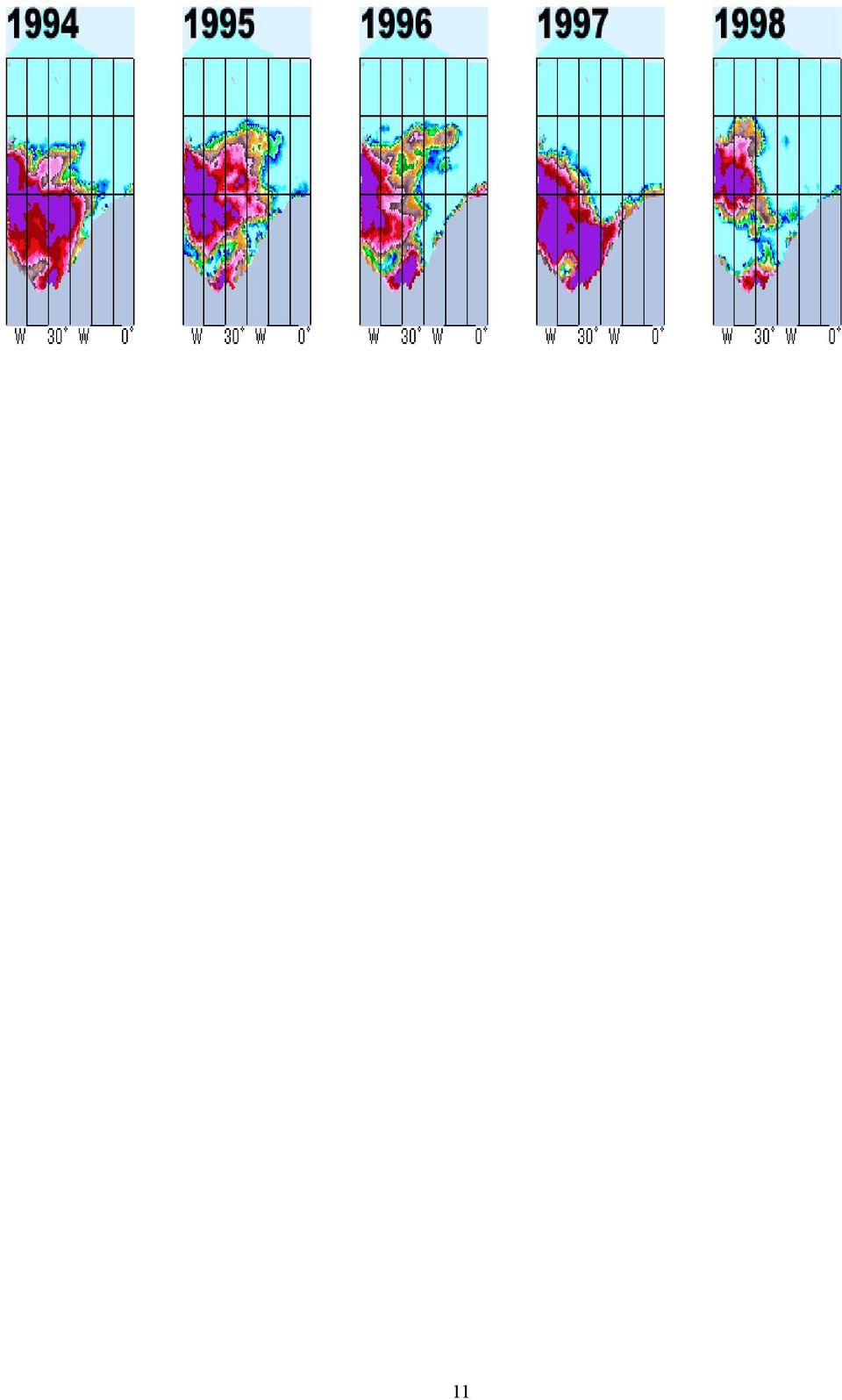
4 RESULTS Monthly averaged sea ice extent image in the Area II in January from 1979 to 2002 was shown in Fig. 2. No large polynya was observed during the satellite observation period except Sighting survey trackline, sighting positions of Antarctic minke whale, ice edge line defined by the survey vessels and satellite derived sea ice concentration data in CPII and CPIII were overlaid in Fig. 3 and Fig. 4, respectively. Positions of ice edge defined by the satellite and the vessel had good agreement though there was some discrepancy between them. The sea ice extent in the southern part of the 1996/97 cruise was larger than that in the 1986/87 cruise. In 1997/98 cruise there was a large polynya which were not observed in the 1986/87 cruise. The area of the polynya was estimated as 78,615 n.mile 2. The total survey area in the 1997/98 was 306,981 n.mile 2. The area of the polynya was 25.6% of the total survey area. The abundance estimates in the polynya using the density estimates from adjacent southern stratum (ES1 and ES2 in Fig. 5) were shown in Table 1. The range of the estimates were from 5,417 to 39,850 individuals. Abundance estimates of CPII and CPIII in Area II in Branch and Butterworth (2001) was summarized in Table 2. CPIII abundance in closing and IO mode was 32% and 20% of CPII, respectively. After including the abundance estimates in the polynya in the estimates in Table 2, the ratio was reduced (Table 3). SeaWiFS image suggested that higher chlorophyll-a concentration was occurred in the polynya region in January 1998 (Fig. 5). The chlorophyll-a concentration in the survey area was low relative to the polynya. DISCUSSION Southern portion of the 1996/97 survey area (0-30 W) had larger amount of sea ice than the 1986/87 survey. Because the heavy sea ice condition in this area limited the growth season of the phytoplankton, biomass of the phytoplankton was low in this area in the summer of 1997 (Hegseth and Von Quillfeldt 2001). Antarctic krill (Euphausia superba), the dominant prey species of Antarctic minke whale (Ichiii and Kato 1991), feed predominantly on the phytoplankton (Miller and Hampton 1989). If the biomass of the phytoplankton was low, growth and sexual development of Anarchistic krill was negatively affected. In the case of the food scarcity, Antarctic minke whales could change the feeding area in response to it. The western Weddell Sea was also covered with high concentration of sea ice in the 1996/97 survey. Because Antarctic minke whales were move across the IWC baleen whale management area boundary (Wada 1984), some proportion of the population in Area II could move to adjacent area, such as Area III. Migration behavior in response to the food availability could affect the change in apparent abundance estimation between CPII and CPIII. In contrast, there was a large polynya in the 1997/98 survey. SeeWiFS satellite image suggested that the primary production in the polynya was high. The size of the polynya increased from November and reached maximum 4

5 (300,000 km 2 = 87,466 n.mile 2 ) about on 1 March (Ackley et al. 2001). The prolonged open water period in the polynya could enhance the primary production. Coastal polynya is observed in the Ross Sea region during spring (Zwally et al. 2001). High density of Antarctic minke whales was also observed in this region (Kasamatsu et al. 1998). SeaWiFS data indicated that high values of chlorophyll were occurred in the Ross Sea region (Moore and Abbott, 2000). In the heavy sea ice coverage year because of the presence of ice berg, the primary production in this area decreased (Arrigo et al. 2002). Abundance estimate in the 1997/98 would be underestimated because of presence of the large polynya. The effect of the polynya on the CPIII abundance estimates in Area II must be taken account though it is difficult to estimate Antarctic minke whale in the south of the ice edge where the sighting vessels can not conduct the survey (IWC 2002). Without considering the effect of the large polynya, the direct comparison of abundance estimates between CPII and CPIII is invalid. ACNOWLEGEMENT Comments from Drs. Hiroshi Htanaka and Hidehiro Kato greatly improve the manuscripts. We thank Atsushi Wada for the sea ice data management. We are grateful to the researchers, captains and crews of IDCR-SWOER for their dedication colletcting cetacean sighting data under hash environmental conditions in the Antarctic. 5
.")
6 REFERENCE Ackley, S. F., Geiger, C. A., King, J. C, Hunke, E. C. and Comiso, J The Ronne Polynya of : observations of air-ice-ocean interaction. Ann. Glaciol. 33: Arrigo, K. R., van Dijken, G. L., Ainley, D. G., Fahnestock, M. A. and Markus, T Ecological impact of a large Antarctic iceberg. Geophys. Res. Letter. 29(7): /201GL Branch, T. A. and Butterworth, D. S Southern Hemisphere minke whales: standardised abundance estimates from the 1978/79 to 1997/98 IDCR-SOWER surveys. J. Cetacean Rea and Manage. 3: Comiso, J. 1999, updated Bootstrap sea ice concentrations from Nimbus-7 SMMR and DMSP SSM/I. Boulder, CO, USA: National Snow and Ice Data Center. Digital media Donovan, G. P A review of IWC stock boundaries. Rep. Int. Whal. Commn (special issue) 13: Ensor, P., Findley, K., Hara, T., Hedley, S., Pitman, R., Sekiguchi, K., Tsuri, T. and Yamagiwa, D IWC-Southern Ocean Whale and Ecosystem Research (IWC-SOWER) Antarctic Cruise, Area II. Paper SC/49/SH7 presented to the IWC Scientific Committee, September, 1997 (unpublished). 47pp [Paper available from the Office of this Journal] Ensor, P., Pastene, L. A., Cawthorn, M., Findlay, K., Hedley, S., Iwakami, H., Kleivane, L., Pitman, R., Tsurui, T. and Sakai, K IWC-Southern Ocean Whale and Ecosystem Research (IWC-SOWER) Antarctic Cruise, Area II. Paper SC/50/Rep1 presented to the IWC Scientific Committee, April 1998 (unpublished). 45pp. [Paper available from the Office of this Journal] Hegseth, E. N. and Von Quillfeldt, C. H Low phytoplankton biomass and ice algal blooms in the Weddell Sea during the ice-filled summer of Antact. Sci. 14: Ichiii, T. and Kato., H Food and daily food consumption of southern minke whale in the Antarctic. Polar. Biol. 11:479:487. Ichii, T., Sinohara, N., Fujise, Y., Nishiwaki, S. and Matsuoka, K Interannual changes in body fat condition index of minke whales in the Antarctic. Mar. Ecol. Prog. Ser. 175: International Whaling Commission Report of Scientific Committee, Annex G. J. Cetacean Rea and Manage. (Suppl.) 4: International Whaling Commission. 2003(a) Report of Scientific Committee, Annex G. J. Cetacean Rea and Manage. (Suppl.) 5:

7 International Whaling Commission. 2003(b). Report of Scientific Committee, Annex G, Appendix 10. J. Cetacean Rea and Manage. (Suppl.) 5: Kasamatsu, F., Ensor, P. and Joyce, G. G Clustering and aggregation of minke whale in the Antarctic feeding ground. Mar. Ecol. Prog. Ser. 168:1-11. Matsuoka, K., Ensor, P., Hakamada, T., Shimada, H., Nishiwaki, S., Kasamatsu, F. and Kato, H Overview of the minke whale sighting survey in IWC/IDCR and SOWER Antarctic cruises from 1878/79 to 2000/01. J. Cetacean Rea and Manage. 5: Miller, D. G. M. and Hampton, I Biology and ecology of the Antarctic krill (Euphausia superba Dana): A review, 9 (Biological investigations of marine Antarctic systems and Stocks (BIOMASS).) Scientific Committee on Antarctic Research and the Scientific Committee on Oceanic research of the International Council of Scientific Unions, Cambridge. Moore, J. K. and Abbott, M. R Phytoplankton chlorophyll distributuions and primary production in the Soutehrn Ocean. J. Gepophs. Res. 105(C12): Shimada, H, Segawa, K. and Murase, H Tentative trial for estimation of Antarctic minke whale abundance within pack ice region incorporating IDCR/SOWER data with meteorological satellite data. Paper SC/53/IA14 presented to the IWC Scientific Committee, July 2001 (unpublished). 45pp. [Paper available from the Office of this Journal] Shimada, H. and Murase, H Further examination of sea ice condition in relation to changes in the Antarctic minke whale distribution pattern in the Antarctic Area IV. Paper SC/55/IA7 presented to the IWC Scientific Committee, May 2003 (unpublished). 6pp. [Paper available from the Office of this Journal] Strindberg, S. and Burt, L IWC Database-Estimation System Software (DESS) User Manual, May Research Unit for Wildlife Population Assessment, Mathematical Institute, University of St Andrews. 300pp. Wada, S Movements of marked minke whales in the Antarctic. Rep. Int. Whal. Commn. 34: Zwally, H. J., Comiso, J. C., Parkinson, C. L. and Cavalieri, D. J Variability of Antarctic sea ice J. Geophys. Res. 107(C5): /2000JC
: A review, 9 (Biological investigations of marine Antarctic systems and Stocks (BIOMASS).")
8 Table 1. Abundance estimates in the polynya observed in 1997/98 cruise. Density estimates in Table 1 of Branch and Butterworth (2001) was used. Survey mode Closing Passing Area of Density Stratum Polynya P (ind.) (ind/n.mile2) (n.mile2) ES ,417 ES ,850 78,615 ES ,157 ES ,439 Table 2. Abundance difference between CPII and CPIII reported in Table 6 of Branch and Butterworth (2001). Survey P (ind) Ratio mode CPII (Year) CPIII (Year) (CPIII/CPII) Closing 142,837 46, /97 & 32% 1986/87 IO 159,596 32, /98 20% Table 3. Abundance difference between CPII and CPIII after including abundance estimates in the polynya in 1997/98. Survey mode Closing IO P (ind) Ratio CPII CPIII(corrected) (Stratum) (CPIII/CPII) 110, ,680 51,831 42,416 ES1 ES1 47% 33% 86,264 38,698 ES2 ES2 78% 30% 8
 Ratio mode CPII (Year) CPIII (Year) (CPIII/CPII) Closing 142,837 46,414 1996/97 & 32% 1986/87 IO 159,596 32,259 1997/98 20% Table 3.")
9 Fig. 1. Schematic map of survey area, Area II. 9

10 Fig. 2. January monthly mean sea ice concentration images in Area II from 1979 to

11 Fig. 2. (Continued) 11
12 Fig. 3. Sighting survey trackline (black line), sighting positions of Antarctic minke whale (pink open circle), ice edge line (red line) defined by the survey vessels and satellite derived sea ice concentration in the 1986/87 CPII Area II cruise. Fig. 4. Sighting survey trackline (black line), sighting positions of Antarctic minke whale (pink open circle), ice edge line (red line) defined by the survey vessels and satellite derived sea ice concentration in the 1996/97 (0-30 W) and 1997/98 (30 W-60 W) CPIII Area II cruise. Pink hatched area was defined as the Ronne Polynya in this study. 12
 and 1997/98 (30 W-60 W) CPIII Area II cruise.")
13 Fig. 5. Strata surveyed in the 1997/98 cruises (from Branch and Butterworth, 2001). Fig. 6. Chlorophyll-a concentration in Area II in January,
. Fig. 6.")
Yearly trend of blubber thickness in the Antarctic minke whale Balaenoptera bonaerensis in Areas IV and V
 JA/J05/JR9 Yearly trend of blubber thickness in the Antarctic minke whale Balaenoptera bonaerensis in Areas IV and V KENJI KONISHI 1), TSUTOMU TAMURA 1) AND LARS WALLØW 2) 1)The Institute of Cetacean Research,
JARPA II* Research Fleet Departs for the Antarctic
 THE INSTITUTE OF CETACEAN RESEARCH 4-5 TOYOMI-CHO, CHUO-KU, TOKYO 104-0055 JAPAN PHONE: +81-3-3536-6521 FAX: +81-3536-6522 MEDIA RELEASE 7 November 2005 JARPA II* Research Fleet Departs for the Antarctic
Temporal variation in snow cover over sea ice in Antarctica using AMSR-E data product
 Temporal variation in snow cover over sea ice in Antarctica using AMSR-E data product Michael J. Lewis Ph.D. Student, Department of Earth and Environmental Science University of Texas at San Antonio ABSTRACT
Mapping of Antarctic sea ice in the depletion phase: an indicator of climatic change?
 Mapping of Antarctic sea ice in the depletion phase: an indicator of climatic change? G. Sreenivasan 1 and T. J. Majumdar 2, * 1 Regional Remote Sensing Service Centre, Nagpur 440 010, India 2 Space Applications
Antarctic summer sea ice concentration and extent: comparison of ODEN 2006 ship observations, satellite passive microwave and NIC sea ice charts
 The Cryosphere, 3, 1 9, 2009 Author(s) 2009. This work is distributed under the Creative Commons Attribution 3.0 License. The Cryosphere Antarctic summer sea ice concentration and extent: comparison of
Antarctic Temperature and Sea Ice Trends over the Last Century
 Antarctic Temperature and Sea Ice Trends over the Last Century High latitude regions of the Earth (the Arctic and Antarctic) have been considered as bellwethers in the detection of global climate change.
Estimating Firn Emissivity, from 1994 to1998, at the Ski Hi Automatic Weather Station on the West Antarctic Ice Sheet Using Passive Microwave Data
 Estimating Firn Emissivity, from 1994 to1998, at the Ski Hi Automatic Weather Station on the West Antarctic Ice Sheet Using Passive Microwave Data Mentor: Dr. Malcolm LeCompte Elizabeth City State University
Present Status of Coastal Environmental Monitoring in Korean Waters. Using Remote Sensing Data
 Present Status of Coastal Environmental Monitoring in Korean Waters Using Remote Sensing Data Sang-Woo Kim, Young-Sang Suh National Fisheries Research & Development Institute #408-1, Shirang-ri, Gijang-up,
Enhanced Sea Ice Concentrations from Passive Microwave Data Josefino C. Comiso NASA Goddard Space Flight Center
 Enhanced Sea Ice Concentrations from Passive Microwave Data Josefino C. Comiso NASA Goddard Space Flight Center 1. Introduction Sea ice concentration is usually defined as the fraction of ice covered area
IMPACT OF REDUCED SEA ICE CONCENTRATION ON THE ANTARCTIC MASS BALANCE. Ian Simmonds
 39 IMPACT OF REDUCED SEA ICE CONCENTRATION ON THE ANTARCTIC MASS BALANCE Ian Simmonds 1. INTRODUCTION The study of climate in polar regions is complicated by the existence of sea ice. Associated with this
BIO-OPTICAL MODELING OF PRIMARY PRODUCTION FROM SEAWIFS OCEAN COLOR DATA FOR THE WESTERN ANTARCTIC PENINSULA REGION
 BIO-OPTICAL MODELING OF PRIMARY PRODUCTION FROM SEAWIFS OCEAN COLOR DATA FOR THE WESTERN ANTARCTIC PENINSULA REGION Raymond C. Smith ICESS, University of California, Santa Barbara, CA 93106 Karen S. Baker
The Effects of Global Warming on the Humpback Whale. Kathleen M. Alluise ATMS 111
 The Effects of Global Warming on the Humpback Whale Kathleen M. Alluise ATMS 111 Getting to know the Humpback Whale Baleen whale Known around the world for their songs, created only by males. Full grown
Radiative effects of clouds, ice sheet and sea ice in the Antarctic
 Snow and fee Covers: Interactions with the Atmosphere and Ecosystems (Proceedings of Yokohama Symposia J2 and J5, July 1993). IAHS Publ. no. 223, 1994. 29 Radiative effects of clouds, ice sheet and sea
Temporal and spatial evolution of the Antarctic sea ice prior to the September 2012 record maximum extent
 GEOPHYSICAL RESEARCH LETTERS, VOL. 40, 5894 5898, doi:10.1002/2013gl058371, 2013 Temporal and spatial evolution of the Antarctic sea ice prior to the September 2012 record maximum extent John Turner, 1
Graphing Sea Ice Extent in the Arctic and Antarctic
 Graphing Sea Ice Extent in the Arctic and Antarctic Summary: Students graph sea ice extent (area) in both polar regions (Arctic and Antarctic) over a three-year period to learn about seasonal variations
BIOLOGICAL MONITORING WITH THE WESTERN CANADIAN ODAS MARINE BUOY NETWORK
 BIOLOGICAL MONITORING WITH THE WESTERN CANADIAN ODAS MARINE BUOY NETWORK Jim Gower, Angelica Peña and Ann Gargett Institute of Ocean Sciences, P.O. Box 6, Sidney, BC, V8L 4B2 Tel: 2 363-68, Fax: 363-6746,
STATEMENT OF WORK. Consulting Agreement Between The University of Miami and REVIEWER
 Background STATEMENT OF WORK Consulting Agreement Between The University of Miami and REVIEWER In the 1995 Alaska Marine Mammal Stock Assessment Reports, the National Marine Fisheries Service (NMFS) defined
"49 39' 49 38.7' E 49 39.0' E 37 46.7' S 37 47.1' S.
 Appendix Template for Submission of Scientific Information to Describe Ecologically or Biologically Significant Marine Areas Note: Please DO NOT embed tables, graphs, figures, photos, or other artwork
POLAR ICE Integrated Arctic and Antarctic Sea Ice monitoring Services
 VTT TECHNICAL RESEARCH CENTRE OF FINLAND LTD Place for a photo (no lines around photo) Photo: Tapio Nyman http://www.polarice.eu/ POLAR ICE Integrated Arctic and Antarctic Sea Ice monitoring Services Robin
Observed variations in multidecadal Antarctic sea ice trends during 1979 2012
 GEOPHYSICAL RESEARCH LETTERS, VOL. 4, 3643 3648, doi:1.12/grl.5715, 213 Observed variations in multidecadal Antarctic sea ice trends during 1979 212 Graham R. Simpkins, 1,2 Laura M. Ciasto, 3,4 and Matthew
SCANS-II Monitoring cetaceans
 SCANS-II Monitoring cetaceans Per Berggren, Jonas Teilmann, David Borchers, Louise Burt, Doug Gillespie, Jonathan Gordon, Phil Hammond, Kelly Macleod, Russell Leaper, Meike Scheidat, René Swift and Arliss
CTD Oceanographic Tags
 CTD Oceanographic Tags The first telemetry tag that links a marine mammal s behavior with its physical environment. Features: Oceanographic quality temperature & salinity profiles Detailed individual dive
Near Real Time Blended Surface Winds
 Near Real Time Blended Surface Winds I. Summary To enhance the spatial and temporal resolutions of surface wind, the remotely sensed retrievals are blended to the operational ECMWF wind analyses over the
Arctic sea ice decline: Faster than forecast
 Click Here for Full Article GEOPHYSICAL RESEARCH LETTERS, VOL. 34, L09501, doi: 10.1029/2007GL029703, 2007 Arctic sea ice decline: Faster than forecast Julienne Stroeve, 1 Marika M. Holland, 2 Walt Meier,
8.3.18 Advice May 2014
 8.3.18 Advice May 2014 ECOREGION STOCK Baltic Sea Sprat in Subdivisions 22 32 (Baltic Sea) Advice for 2015 ICES advises on the basis of the MSY approach that catches in 2015 should be no more than 222
http://bco-dmo.org Go to: http://usjgofs.whoi.edu/jg/dir/jgofs/ URL: http://usjgofs.whoi.edu/jg/serv/jgofs/arabian/inventory.html0
 http://bco-dmo.org DATA ACCESS TUTORIAL 2012 OCB PI Summer Workshop Data access: catalog browse scenario 1: you are a former US JGOFS or US GLOBEC researcher, and you know what data you are looking for
Antarctica Project - Fact File and References
 Antarctica Project - Fact File and References Enough information to get started, or perhaps enough in itself for a younger age group. Physical: Antarctica is regarded as being the continent of Antarctica,
Large-scale climate and local weather drive interannual variability in Adélie penguin chick fledging mass
 The following supplements accompany the article Large-scale climate and local weather drive interannual variability in Adélie penguin chick fledging mass Megan A. Cimino 1, *, William R. Fraser 2, Donna
Setline survey-based apportionment estimates
 Setline survey-based apportionment estimates Raymond A. Webster and Ian J. Stewart Abstract Setline survey weight per unit effort (WPUE) of halibut is used to estimate how the coastwide stock is distributed
Ecological responses of Antarctic krill to environmental variability: can we predict the future?
 Antarctic Science 19 (2), 253 266 (2007) Antarctic Science Ltd Printed in the UK DOI: 10.1017/S0954102007000363 Ecological responses of Antarctic krill to environmental variability: can we predict the
West Coast Charter Boat Survey Summary Report ~2000~
 West Coast Charter Boat Survey Summary Report ~2000~ Pacific States Marine Fisheries Commission Economics Data Program January 2004 205 SE Spokane St, Suite 100 Portland, OR 97202-6413 (503)-595-3100 efin@psmfc.org
Ecosystem-Based Management: Making it Work in the EU Dr. Ronán Long
 Ecosystem-Based Management: Making it Work in the EU www.marinelaw.ie Overview 1. Context 2. Definitions 3. Legal Basis: International & Regional Law EU Law 4. Conclusions The Context Commission Report
Our Antarctic Facilities
 Our Antarctic Facilities Australian Activities in Antarctica Tony Worby IICWG Chile, October 2014 3 days Macquarie Island Wilkins aerodrome Hobart is Australia s Gateway to East Antarctica and the Southern
EMODnet Biology. bio.emodnet.eu
 EMODnet Biology bio.emodnet.eu EM 2 OD net Building upon EMODnet preparatory action: 2009-2012 Temporal/Spatial distribution Phytoplankton, Zooplankton, Angiosperms, Macro-algae, Invertebrate bottom fauna,
Supporting Online Material for
 www.sciencemag.org/cgi/content/full/311/5768/1747/dc1 Supporting Online Material for Paleoclimatic Evidence for Future Ice-Sheet Instability and Rapid Sea- Level Rise Jonathan T. Overpeck,* Bette L. Otto-Bliesner,
IMO ANY OTHER BUSINESS. Shipping noise and marine mammals. Submitted by the United States
 INTERNATIONAL MARITIME ORGANIZATION E IMO MARINE ENVIRONMENT PROTECTION COMMITTEE 57th session Agenda item 20 MEPC 57/INF.4 17 December 2007 ENGLISH ONLY ANY OTHER BUSINESS Shipping noise and marine mammals
Research Advice on the Proposed Shark Mitigation Strategy using drum lines for January to April 2014. Research Division - January 2014
 Research Advice on the Proposed Shark Mitigation Strategy using drum lines for January to April 2014 File No 2475/13 Background Research Division - January 2014 In direct response to the unprecedented
An ice-core record of Antarctic sea-ice extent in the southern Indian Ocean for the past 300 years
 Annals of Glaciology 56(69) 2015 doi: 10.3189/2015AoG69A719 451 An ice-core record of Antarctic sea-ice extent in the southern Indian Ocean for the past 300 years C. XIAO, 1,2 T. DOU, 3,1 S.B. SNEED, 4
Title. Euphausia superba. Author. Sophia Erb
 Title Using geometric probability to compare the random and actual mating success of Atlantic Krill, Euphausia superba Author Sophia Erb Abstract Currently the most abundant species on Earth, Atlantic
DISMAR: Data Integration System for Marine Pollution and Water Quality
 DISMAR: Data Integration System for Marine Pollution and Water Quality T. Hamre a,, S. Sandven a, É. Ó Tuama b a Nansen Environmental and Remote Sensing Center, Thormøhlensgate 47, N-5006 Bergen, Norway
Ice thickness in the Beaufort Sea and Northwest Passage in April 2016, and comparison with April 2015
 Ice thickness in the Beaufort Sea and Northwest Passage in April 2016, and comparison with April 2015 Christian Haas, Anne Bublitz, Alec Casey, Justin Beckers, York University, Toronto, Canada Contact:
9.3.7 Advice December 2014
 9.3.7 Advice December 2014 ECOREGION STOCK Widely distributed and migratory stocks European eel Advice for 2015 The status of eel remains critical and ICES advises that all anthropogenic mortality (e.g.
Pacific Scientific Review Group Conference Call / Webinar Monday, 27 Oct 2014. -- Call Summary --
 Pacific Scientific Review Group Conference Call / Webinar Monday, 27 Oct 2014 -- Call Summary -- 1. Introduction and logistics (Forney/Scott) Karin Forney and Michael Scott welcomed and thanked the call
National Snow and Ice Data Center
 National Snow and Ice Data Center This data set (NSIDC-0484), part of the NASA Making Earth System Data Records for Use in Research Environments (MEaSUREs) Program, provides the first comprehensive, high-resolution,
Thoughts on Richter et al. presentation. David Parrish - NOAA ESRL
 Thoughts on Richter et al. presentation David Parrish - NOAA ESRL Analysis of satellite data moving from pretty pictures to quantitative results. Richter et al. represents one of at least 5 groups pursuing
SOUTHERN OCEAN CURRENTS. http://www.polar.org/antsun/oldissues2002-2003/sun121502/current.html
 Map from: SOUTHERN OCEAN CURRENTS http://www.polar.org/antsun/oldissues2002-2003/sun121502/current.html FROM: The Antarctic Coastal Current Joanna Gyory, John Cangialosi, Ieng Jo, Arthur J. Mariano, Edward
2016 Outlook and Management -Pre-season outlook / expectations and early indications - General overview of in-season management approach
 Salmon Briefing 2016 Outlook and Management -Pre-season outlook / expectations and early indications - General overview of in-season management approach Pacific Salmon Species Size and age at return varies
II. Related Activities
 (1) Global Cloud Resolving Model Simulations toward Numerical Weather Forecasting in the Tropics (FY2005-2010) (2) Scale Interaction and Large-Scale Variation of the Ocean Circulation (FY2006-2011) (3)
Gray Whales on the Move
 Gray Whales on the Move Students trace the migration route of a gray whale and discover the gray whale s natural history. Subjects Science GRADE LEVEL Grades 6 8 TIME 60 minutes OBJECTIVES Students will
A novel mammalian social structure in Indo-pacific bottlenose. dolphins (Tursiops sp.): complex male-male alliances in an. open social network
: complex male-male alliances in an. open social network") Electronic Supplementary Material A novel mammalian social structure in Indo-pacific bottlenose dolphins (Tursiops sp.): complex male-male alliances in an open social network METHODS To control for artificial
Electronic Supplementary Material A novel mammalian social structure in Indo-pacific bottlenose dolphins (Tursiops sp.): complex male-male alliances in an open social network METHODS To control for artificial
DISTRIBUTION AND SIZE AGE COMPOSITION OF ANTARCTIC KRILL (EUPHAUSIA SUPERBA) IN THE SOUTH ORKNEY ISLANDS REGION (CCAMLR SUBAREA 48.
 IN THE SOUTH ORKNEY ISLANDS REGION (CCAMLR SUBAREA 48.") CCAMLR Science, Vol. 18 (011): 1 1 DISTRIBUTION AND SIZE AGE COMPOSITION OF ANTARCTIC KRILL (EUPHAUSIA SUPERBA) IN THE SOUTH ORKNEY ISLANDS REGION (CCAMLR SUBAREA 8.) D.O. Sologub* VNIRO 17 V. Krasnoselskaya
CCAMLR Science, Vol. 18 (011): 1 1 DISTRIBUTION AND SIZE AGE COMPOSITION OF ANTARCTIC KRILL (EUPHAUSIA SUPERBA) IN THE SOUTH ORKNEY ISLANDS REGION (CCAMLR SUBAREA 8.) D.O. Sologub* VNIRO 17 V. Krasnoselskaya
Safety Challenges in the Arctic
 Safety Challenges in the Arctic International Conference on Integrated Operations in the Petroleum Industry Trondheim, 25.09.13 Børre Johan Paaske, DNV GL Agenda Defining the Arctic Safety and environmental
Satellite SST Product Development Proposal
 Call for Proposals under the IMOS (EIF) Five Year Strategy: Enhancement or extension of IMOS July 2009 to June 2013 Satellite SST Products Sub-Facility Plan Overview: Proposed Infrastructure Investment:
Slide 1. Slide 2. Slide 3
 Satellite Analysis of Sea Surface Temperatures in the Florida Keys to Monitor Coral Reef Health NASA Stennis Space Center Earthzine/DEVELOP Virtual Poster Session, Summer 2011 Video Transcript Slide 1
Technical note on MISR Cloud-Top-Height Optical-depth (CTH-OD) joint histogram product
 joint histogram product") Technical note on MISR Cloud-Top-Height Optical-depth (CTH-OD) joint histogram product 1. Intend of this document and POC 1.a) General purpose The MISR CTH-OD product contains 2D histograms (joint distributions)
Technical note on MISR Cloud-Top-Height Optical-depth (CTH-OD) joint histogram product 1. Intend of this document and POC 1.a) General purpose The MISR CTH-OD product contains 2D histograms (joint distributions)
Meris Reflectance and Algal-2 validation at the North Sea
 Meris Reflectance and Algal-2 validation at the North Sea Steef W.M. Peters IVM, De Boelelaan 187, 181 HV Amsterdam, Netherlands (steef.peters at ivm.vu.nl) Abstract In this paper spectral reflectances
Monitoring of Arctic Conditions from a Virtual Constellation of Synthetic Aperture Radar Satellites
 DISTRIBUTION STATEMENT A. Approved for public release; distribution is unlimited. Monitoring of Arctic Conditions from a Virtual Constellation of Synthetic Aperture Radar Satellites RSMAS Department of
Song Characteristics of Different Baleen Whales : A New Approach to Sound Analysis. Pranab Kumar Dhar, Jong-Myon Kim
 Song Characteristics of Different Baleen Whales : A New Approach to Sound Analysis Pranab Kumar Dhar, Jong-Myon Kim 90 > Abstract This paper presents the characteristics of different baleen whale songs
Coastal Southern Ocean: A strong anthropogenic CO 2 sink
 Click Here for Full Article GEOPHYSICAL RESEARCH LETTERS, VOL. 35, L21602, doi:10.1029/2008gl035624, 2008 Coastal Southern Ocean: A strong anthropogenic CO 2 sink Kevin R. Arrigo, 1 Gert van Dijken, 1
Ice Secrets Revealed - New York University Climbing
 IEEE TRANSACTIONS ON GEOSCIENCE AND REMOTE SENSING, VOL. 42, NO. 7, JULY 2004 1433 Automatic Detection and Validity of the Sea-Ice Edge: An Application of Enhanced-Resolution QuikScat/SeaWinds Data Jörg
Near-ubiquity of ice-edge blooms in the Arctic
 Biogeosciences, 8, 515 524, 2011 doi:10.5194/bg-8-515-2011 Author(s) 2011. CC Attribution 3.0 License. Biogeosciences Near-ubiquity of ice-edge blooms in the Arctic M. Perrette 1,*, A. Yool 1, G. D. Quartly
Where Will the Polar Bears Go?
 Service Stewardship Where Will the Polar Bears Go? Courtesy Kaathy Crane, NOAA Arctic Research Office Science Protect the Earth The Arctic is one of the least explored places on earth, and is changing
AMSRIce03 Sea Ice Thickness Data
 Notice to Data Users: The documentation for this data set was provided solely by the Principal Investigator(s) and was not further developed, thoroughly reviewed, or edited by NSIDC. Thus, support for
4 Decades of Belgian Marine Monitoring. presented by Karien De Cauwer, RBINS, Belgian Marine Data Centre
 4 Decades of Belgian Marine Monitoring presented by Karien De Cauwer, RBINS, Belgian Marine Data Centre 47 th International Liege colloquium, Liège, 4-8 th May 2015 Uplifting historical data to today s
Japan s Arctic Policies with regards to Maritime Law and Jurisdictional Issues
 1 Japan s Arctic Policies with regards to Maritime Law and Jurisdictional Issues Prof T Ikeshima LLB, LLM, DES, PhD Waseda University 2 Outline Introduction: geographical background Japan s interests and
Establishing large-scale trans-boundaries MPA networks: the OSPAR example in North-East Atlantic
 Establishing large-scale trans-boundaries MPA networks: the OSPAR example in North-East Atlantic Introduction A pledge to establish a representative network of marine and coastal protected areas by 2012
How to analyze synoptic-scale weather patterns Table of Contents
 How to analyze synoptic-scale weather patterns Table of Contents Before You Begin... 2 1. Identify H and L pressure systems... 3 2. Locate fronts and determine frontal activity... 5 3. Determine surface
COASTAL MONITORING & OBSERVATIONS LESSON PLAN Do You Have Change?
 Coastal Change Analysis Lesson Plan COASTAL MONITORING & OBSERVATIONS LESSON PLAN Do You Have Change? NOS Topic Coastal Monitoring and Observations Theme Coastal Change Analysis Links to Overview Essays
Proportion of large fish in the community
 Authors Demersal community: Daniel Oesterwind, Iwona Psuty, Marzenna Pachur, Christian von Dorrien & Adam Lejk Pelagic community: Michele Casini, Niklas Larson Reference to this core indicator report:
Approaches to biogeographic classification of the world s oceans. Marjo Vierros United Nations University Institute of Advanced Studies
 Approaches to biogeographic classification of the world s oceans Marjo Vierros United Nations University Institute of Advanced Studies This presentation will cover International policy developments of
A METHODOLOGY FOR GIS INTERFACING OF MARINE DATA
 A METHODOLOGY FOR GIS INTERFACING OF MARINE DATA Proceedings of GIS PLANET 98: International Conference and Exhibition on Geographic Information, Lisbon, Portugal, 7-11 September 1998 Vasilis Valavanis,
Interaction between Antarctic sea ice and synoptic activity in the circumpolar trough: implications for ice-core interpretation
 Annals of Glaciology 52(57) 2011 9 Interaction between Antarctic sea ice and synoptic activity in the circumpolar trough: implications for ice-core interpretation Elisabeth SCHLOSSER, 1 Jordan G. POWERS,
Expansion of metadata management, visualization and data processing functionality of OBIS-SEAMAP for passive acoustic monitoring data
 Expansion of metadata management, visualization and data processing functionality of OBIS-SEAMAP for passive acoustic monitoring data Dr. Patrick N. Halpin Duke University Box 90328 Durham, NC 27708-0328
THE FISHERIES REQUIREMENTS FOR AREA IN RELATION TO SEISMIC ACTIVITIES THE FISHERIES
 THE FISHERIES REQUIREMENTS FOR AREA IN RELATION TO SEISMIC ACTIVITIES THE FISHERIES The fish stocks in the Norwegian sector can be divided into two separate categories: The pelagic species comprise herring,
Bipolar Atlantic Thermohaline Circulation (BIAC) a IPY proposal coordinated by Tor Gammelsrød Geophysical Institute, University of Bergen
 a IPY proposal coordinated by Tor Gammelsrød Geophysical Institute, University of Bergen") Bipolar Atlantic Thermohaline Circulation (BIAC) a IPY proposal coordinated by Tor Gammelsrød Geophysical Institute, University of Bergen The role of the Thermohaline Circulation (THC) as a driving force
Bipolar Atlantic Thermohaline Circulation (BIAC) a IPY proposal coordinated by Tor Gammelsrød Geophysical Institute, University of Bergen The role of the Thermohaline Circulation (THC) as a driving force
Chapter Overview. Seasons. Earth s Seasons. Distribution of Solar Energy. Solar Energy on Earth. CHAPTER 6 Air-Sea Interaction
 Chapter Overview CHAPTER 6 Air-Sea Interaction The atmosphere and the ocean are one independent system. Earth has seasons because of the tilt on its axis. There are three major wind belts in each hemisphere.
North Pacific Anadromous Fish Commission
 NPAFC DOC. 981 Hatchery and wild percentages of coho salmon in the Strait of Georgia are related to shifts in species dominance by R.J. Beamish, R.M. Sweeting, C.M. Neville, and K. Lange Fisheries and
Fresh Ideas, New Frontiers
 Fresh Ideas, New Frontiers Center for Earth System Research and Sustainability at Universität Hamburg Preface Core Issues and Research Program 2020 Fresh Ideas, New Frontiers Thinking outside the box to
Stage 4. Geography. Blackline Masters. By Karen Devine
 1 Devine Educational Consultancy Services Stage 4 Geography Blackline Masters By Karen Devine Updated January 2010 2 This book is intended for the exclusive use in NSW Secondary Schools. It is meant to
SUBSIDIARY LEGISLATION WILDLIFE & PROTECTED AREAS. Marine Protected Areas Order 2012. S. R. & O. No: 1 of 2012
 SUBSIDIARY LEGISLATION WILDLIFE & PROTECTED AREAS Marine Protected Areas Order 2012 S. R. & O. No: 1 of 2012 Made: 23 February 2012 Published: 29 February 2012 Coming into force: on publication IN EXERCISE
Data Sets of Climate Science
 The 5 Most Important Data Sets of Climate Science Photo: S. Rahmstorf This presentation was prepared on the occasion of the Arctic Expedition for Climate Action, July 2008. Author: Stefan Rahmstorf, Professor
Sperry Marine Fleet Management Enterprise Solution
 Sperry Marine Fleet Management Enterprise Solution Performance Based Navigation (PBN) Fuel Navigator Module Alan Aitken Canadian Regional Manager Definition Fleet Management A way of managing infrastructure
Earth Systems. atmosphere, geosphere, biosphere, hydrosphere. Made by Liesl at homeschoolden.com
 Earth Systems atmosphere, geosphere, biosphere, hydrosphere You may make as many copies as you need for your homeschool or classroom. Feel free to link to the original post. Feel free to use the image
Antarctic krill (Euphausia superba; figure 1) is one
 is one") Krill, Currents, and Sea Ice: Euphausia superba and Its Changing Environment STEPHEN NICOL Investigations of Antarctic krill (Euphausia superba) over the last 40 years have examined almost every aspect
Krill, Currents, and Sea Ice: Euphausia superba and Its Changing Environment STEPHEN NICOL Investigations of Antarctic krill (Euphausia superba) over the last 40 years have examined almost every aspect
Annex VIII. Development of the portal site on remote sensing. (Reviewed by the Second Meeting of NOWPAP WG4)
") Page 1 Development of the portal site on remote sensing (Reviewed by the Second Meeting of NOWPAP WG4) Page 1 Development of the portal site on remote sensing 1 Background Based on the consideration in
Page 1 Development of the portal site on remote sensing (Reviewed by the Second Meeting of NOWPAP WG4) Page 1 Development of the portal site on remote sensing 1 Background Based on the consideration in
Environmental Monitoring of Lake Michigan Using CoastWatch Data and JAVA GIS
 Environmental Monitoring of Lake Michigan Using CoastWatch Data and JAVA GIS Page 1 of 12 Environmental Monitoring of Lake Michigan Using CoastWatch Data and JAVA GIS George A. Leshkevich and Songzhi Liu
16 th IOCCG Committee annual meeting. Plymouth, UK 15 17 February 2011. mission: Present status and near future
 16 th IOCCG Committee annual meeting Plymouth, UK 15 17 February 2011 The Meteor 3M Mt satellite mission: Present status and near future plans MISSION AIMS Satellites of the series METEOR M M are purposed
Monitoring of Arctic Conditions from a Virtual Constellation of Synthetic Aperture Radar Satellites
 DISTRIBUTION STATEMENT A. Approved for public release; distribution is unlimited. Monitoring of Arctic Conditions from a Virtual Constellation of Synthetic Aperture Radar Satellites Hans C. Graber RSMAS
NASA Earth System Science: Structure and data centers
 SUPPLEMENT MATERIALS NASA Earth System Science: Structure and data centers NASA http://nasa.gov/ NASA Mission Directorates Aeronautics Research Exploration Systems Science http://nasascience.nasa.gov/
Shannon Rauch. Summer ESIP 2015 14 July 2015
 Supporting Citation of Subsetted Data: A Data Center s Perspective Shannon Rauch Summer ESIP 2015 14 July 2015 Why Cite Data? "Data citation is intended to help guard the integrity of scholarly conclusions"
Climate, water and renewable energy in the Nordic countries
 102 Regional Hydrological Impacts of Climatic Change Hydroclimatic Variability (Proceedings of symposium S6 held during the Seventh IAHS Scientific Assembly at Foz do Iguaçu, Brazil, April 2005). IAHS
The Fram Centre Research in the high north under innovative structure
 The Fram Centre Research in the high north under innovative structure December 2014 Nina Mari Jørgensen, Norwegian Polar Institute Photo: Jo Aarseth, Kongsfjorden, Svalbard August 2013 Governmental support
Coral Reef Watch A Satellite View. AE Strong. Satellite SST Anomalies. January 2002 May 2003
 Coral Reef Watch A Satellite View AE Strong Satellite SST Anomalies January 2002 May 2003 Coral Reefs, Climate, and Coral Bleaching Workshop June 18-20, 2003 Turtle Bay, Oahu, HI NOAA s Program Leaders:
PROGNOSES OF SEA-FISH SPECIES CATCHES IN GREECE AT BIOLOGICAL AND BIODIVERSITY RISK
 Journal of Environmental Protection and Ecology 16, No 1, 92 97 (2015) Risk management PROGNOSES OF SEA-FISH SPECIES CATCHES IN GREECE AT BIOLOGICAL AND BIODIVERSITY RISK G. TEGOS a *, K. ONKOV b a Applied
Circumpolar connections between Antarctic krill (Euphausia superba Dana) populations: Investigating the roles of ocean and sea ice transport
 populations: Investigating the roles of ocean and sea ice transport") Deep-Sea Research I 54 (2007) 792 810 www.elsevier.com/locate/dsri Circumpolar connections between Antarctic krill (Euphausia superba Dana) populations: Investigating the roles of ocean and sea ice transport
Deep-Sea Research I 54 (2007) 792 810 www.elsevier.com/locate/dsri Circumpolar connections between Antarctic krill (Euphausia superba Dana) populations: Investigating the roles of ocean and sea ice transport
Whale Wars in Seattle: A U.S. Court Discusses Antarctic Whaling
 Marine conservation, science, education, research, and a sea ethic Marine Conservation Marine Life News Climate Change Announcements Marine Science MarineBio Forums Record Press, Inc. Appellate Litigation
Acoustic monitoring of Japanese anchovy Engraulis japonicus post larvae shirasu
 Title Acoustic monitoring of Japanese anchovy Engraulis japonicus post larvae shirasu K. Miyashita,, A. Watanabe, S. Morioka, Y. Ikewaki,, R. Matsukura,, and H. Yasuma Engraulis japonicus Shirasu fishery
ANNOUNCEMENT OF FEDERAL FUNDING OPPORTUNITY EXECUTIVE SUMMARY
 ANNOUNCEMENT OF FEDERAL FUNDING OPPORTUNITY EXECUTIVE SUMMARY Federal Agency Name(s): Oceanic and Atmospheric Research (OAR), National Oceanic And Atmospheric Administration, Department of Commerce Funding
Fisheries Management: Arctic principles
 Fisheries Management: Arctic principles Spatial issues in the Arctic Marine Resource Management Stockholm 4-6 September 2014 Niels Vestergaard Department of Environmental and Business Economics Centre
In-situ measurements and analysis of ocean waves in the Antarctic marginal ice zone
 In-situ measurements and analysis of ocean waves in the Antarctic marginal ice zone Michael H. Meylan 1, Luke G. Bennetts 2 and Alison L. Kohout 3 1 School of Mathematical and Physical Science, University