Recommended on April 5, 1995 by the High Point Planning and Zoning Commission. Adopted on June 1, 1995 by the High Point City Council
|
|
|
- Chester Sharp
- 8 years ago
- Views:
Transcription
1
2 Recommended on April 5, 1995 by the High Point Planning and Zoning Commission Adopted on June 1, 1995 by the High Point City Council The was prepared in collaboration with the planning departments of High Point, Greensboro, and Guilford County and the transportation departments of High Point and Greensboro. THIS PRINTED MATERIAL WILL BE PROVIDED IN AN ALTERNATIVE FORMAT UPON REQUEST

3
4 Table of Contents Executive Summary 1 The Plan 7 Introduction 7 Transportation 8 Land Use 12 Environmental Factors 16 Visual Quality 17 Appendix 21 Transportation Standards 21 Traffic Impact Analysis Requirements 23 Sign Requirements 25 Landscaping Requirements 26 Development Design Requirements 27 Land Use Classifications 28

5 Executive Summary INTRODUCTION Because of rapid and continuing development in the West Wendover Avenue Corridor and planned transportation improvements in the vicinity, it is appropriate now for Greensboro, Guilford County and High Point to review the recommendations contained in the 1989 West Wendover Avenue Corridor Study. Due to changed conditions, the scope of this plan update and its title have been altered to include the Guilford College Road corridor near Wendover Avenue. The four core topics to be addressed are transportation, land use, environmental factors and visual quality. TRANSPORTATION (page 8) Issues: Protecting West Wendover Avenue as a commuting corridor Impact of Greensboro's proposed Western Loop connecting Interstate 40 and Interstate 85 Impact of the construction of Piedmont Parkway from Tarrant Road to Guilford College Road Objectives: 1. To maintain West Wendover Avenue as a major traffic carrier rather than a local service road. 2. To provide alternate routes in the larger area through selected road connections. 3. To minimize the impacts of development on major traffic circulation interchanges and intersections. Recommendations: 1. Vehicular access to West Wendover Avenue and Guilford College Road should be restricted and the number of median crossings on Wendover Avenue should not be increased. Page 1

6 Executive Summary 2. The following projects, which are included in the North Carolina Transportation Improvement Program (TIP), should be retained: a. Greensboro's Western Loop b. Guilford College Road 3. The following road projects should be added to the TIP: a. Ruffin Road extension b. Stanley Road/Bridford Parkway connector (north of the proposed Greensboro Western Loop) c. Bridford Parkway d. Hilltop Road e. Piedmont Parkway 4. Vehicular access should be controlled along: a. West Wendover Avenue within 500 feet of a major intersecting street b. Guilford College Road at West Wendover Avenue 5. Development proposals should show the ability to accommodate alternative modes of transportation (e.g. bus shelters and pull-out lanes). LAND USE (page 12) Issues: Continued development of the Interstate 40 and N.C. Highway 68 commercial nodes Increasing density of future residential development Page 2
.")
7 Executive Summary Objectives: 1. To avoid strip development along Guilford College Road and West Wendover Avenue. 2. To concentrate community/regional commercial uses at each end of the corridor, specifically at the I-40/Wendover and N.C. Highway 68/Wendover intersections, and to focus residential, neighborhood commercial, and office/institutional uses near the intersection of Guilford College Road, West Wendover Avenue and Greensboro's Western Loop. 3. To preserve the existing low-density residential areas along Hilltop Road and Guilford College Road and to respect their character. 4. To encourage the conservation of existing neighborhoods and to protect them from intrusive development. 5. To accommodate higher density residential development, especially north of West Wendover Avenue and outside of the Watershed Critical Area, in specified locations. 6. To acquire additional park land for active recreation use. 7. To protect historic and cultural resources such as the Deep River Friends Meeting. Recommended Changes (see Map 3 following page 15): Area 1 - From Community/Regional Commercial to Office. Area 2 - From Low-Density Residential to High-Density Residential. Area 3 - From Low- and Medium-Density Residential to Restricted Industrial. Area 4 - From Low-Density Residential to Medium-Density Residential. Area 5 - From Low-Density Residential to High-Density Residential. Area 6 - From Low-Density Residential to Office. Area 7 - From Low-Density Residential to High-Density Residential. Area 8 - From Low-Density and Medium-Density Residential to Highdensity Residential. Page 3

8 Executive Summary Area 9 - From Low-Density Residential to Office. Area 10 - Remaining mainly Low-Density Residential with a portion to Local/Convenience Commercial and Office. Area 11 - From Medium-Density Residential to Public/Institutional. Area 12 - From Medium-Density to High-Density Residential. Area 13 - From Light Industrial to Community/Regional Commercial. ENVIRONMENTAL FACTORS (page 16) Issues: Protection of existing and future drinking water watersheds while accommodating needed non-residential land uses Extension of the greenway system Objectives: 1. To protect drinking water supply watersheds. 2. To ensure an adequate amount of open space is maintained. 3. To protect flood plains and environmentally sensitive lands. 4. To preserve existing vegetation where possible and to replace removed vegetation where necessary. 5. To expand the greenway trail system. Recommendation: Land along Long Branch between West Wendover Avenue and the Deep River should be acquired for a greenway and for eventual trail development. Page 4

9 Executive Summary VISUAL QUALITY (page 17) Issues: Corridors are gateways between Greensboro, High Point and Jamestown Buffering and landscaping requirements Sign control Development standards/design guidelines Objective: To ensure the maintenance of a high visual quality in the West Wendover Avenue Corridor with appropriate standards for signs, landscaping, buffer yards, setbacks and design guidelines. Recommendation: A West Wendover Avenue Scenic Corridor Overlay Zoning District should be established and incorporated into the Development Ordinances of Guilford County, Greensboro and High Point. Page 5

10

11 The Plan INTRODUCTION The West Wendover Avenue corridor between Interstate 40 and N.C. Highway 68 was the subject of a joint study by Guilford County, Greensboro and High Point in The genesis of that study was the projected widening of West Wendover Avenue from a two-lane facility to a six-lane facility divided by a planted median. Four lanes are now being constructed west of Guilford College Road as an intermediate step, with adequate right-of-way reserved to widen the street to six lanes in the future. This project was planned because the route was becoming increasingly important for commuter traffic between High Point and Greensboro. Because of rapid and continuing development, particularly on the former Camp Uwharrie Boy Scout property and at the intersection of Interstate 40 and Wendover Avenue, and planned transportation improvements, especially the proposed Greensboro Western Loop, it is appropriate now for the jurisdictions to review the recommendations contained in that study. The pace and scale of post-1989 development was not anticipated; the recommendations contained in this plan will reflect changed conditions and are intended to guide future development along the West Wendover corridor. Due to these changed conditions, the scope of the plan and its title have been altered to include the Guilford College Road corridor near West Wendover Avenue. The four core topics to be addressed are transportation, land use, environmental factors and visual quality. The area included in this update extends from the intersection of West Wendover Avenue and Interstate 40 in Greensboro to the intersection of West Wendover Avenue and N.C. Highway 68 in High Point and generally includes those properties with frontage on Wendover Avenue. The corridor also extends approximately 5,000 feet south along Guilford College Road from its intersection with West Wendover Avenue to Akela Trail. The corridor contains approximately 4,783 acres (7.47 square miles). The West Wendover Avenue Corridor Study has not been officially revised prior to this update. However, in 1992 High Point adopted its Land Use Plan, which, while substantially consistent with the corridor plan, did differ in two areas. High Point's Land Use Plan contains a number of Focal Areas--large development parcels along major thoroughfares for which a range of potential land uses are described. Two of these focal areas are located in the West Wendover Avenue Corridor between Long Branch and Guilford College Road. The Wendover Avenue/Proposed Piedmont Parkway Focal Area is designated for a mixture of residential densities and supporting office and local commercial uses, with open space preserved along Long Branch. The Wendover Avenue/Guilford College Road Focal Area is reserved for similar uses. The relocation of Piedmont Parkway to the east had the effect of compressing the two Focal Areas into one, but the area is developing as envisioned in the 1992 High Point Page 7

12 The Plan Land Use Plan. The 1989 plan called for medium- and low-density residential development in this vicinity, save for a small, existing commercial use at the southwest corner of the West Wendover Avenue and Guilford College Road intersection. Access to Wendover Avenue from both Focal Areas was proposed to be restricted under the guidelines set forth in the 1989 West Wendover Avenue Corridor Study. As noted earlier, development in the corridor has been rapid and is continuing. In the corridor's interior west of Guilford College Road, the nearly 200-acre former Camp Uwharrie Boy Scout property has been approved for development and is developing with a mixture of low-, medium- and high-density residential uses and supporting commercial and office uses. In addition, other low- and medium-density residential developments totaling some 130 acres have been approved or are under consideration. Finally, development in Piedmont Centre shows no signs of abating and is reaching Wendover Avenue. East of Guilford College Road, development in the interior of the corridor has been less extensive because much of it is already developed. The significant growth at the corridor's eastern and western nodes will be discussed in the Land Use Issues section of this report. Some issues raised in 1989 still remain, while others requiring attention have emerged as a result of continuing development and zoning changes in the West Wendover Avenue/Guilford College Road Corridor. These planning issues frame the discussion about these corridors and provide a background for the objectives and recommendations found in this plan. TRANSPORTATION ISSUES Protecting West Wendover Avenue as a Commuting Corridor The widening of West Wendover Avenue between Greensboro and High Point, scheduled for completion in late 1996, is the result of the route's increasing importance as a commuter corridor between the two cities. The maintenance of Wendover Avenue's ability to move traffic efficiently and safely is key to its success as a major thoroughfare. This importance is amply illustrated by the fact that the rate of growth in traffic counts has greatly exceeded past projections, which will be further detailed below. This trend raises the question of whether the designed capacity of West Wendover Avenue will be sufficient in the future and emphasizes the vital nature of Wendover Avenue as a commuter route. Access control from properties within the corridor is therefore a critical concern, because vehicles entering and exiting a roadway can seriously interrupt traffic movement. Impacts of Piedmont Parkway and the Western Loop Page 8

13 The Plan In addition to the widening of West Wendover Avenue, two other significant transportation projects are slated for the corridor. First is the construction of a road connecting Piedmont Parkway in Piedmont Centre and Hilltop Road. The road is currently under construction on the former Camp Uwharrie property between Wendover Avenue and Guilford College Road. When completed, this road will link large residential areas in Greensboro and High Point with employment centers along High Point Road and N.C. Highway 68. Second, Greensboro's Western Loop, which will connect Interstate 40 and the proposed Interstate 85 Bypass, is now scheduled to be constructed very close to the existing intersection of Wendover Avenue and Guilford College Road. There will be full interchanges with both roads, and the project will also cause the realignment of Guilford College Road to the west. By the year 2010, the Western Loop is projected to carry about 70,000 vehicles per day at its intersection with West Wendover Avenue, and a projection of 43,500 vehicles per day on West Wendover Avenue by the same year was used in designing the widening project for the road. However, a 1994 traffic count on Wendover Avenue west of Stanley Road showed 37,000 vehicles per day, a rate of growth faster than anticipated. This traffic will bring pressure for regional development reserved by the 1989 corridor study for the N.C. Highway 68 and Interstate 40 intersections with Wendover Avenue. Market forces tend to create a demand for commercial development at the intersections of heavily traveled roads. Region-based commercial development, though concentrated initially, often leads to secondary commercial development occurring in strips along the roads, which would be extremely undesirable for traffic management, environmental and aesthetic reasons in the West Wendover Avenue Corridor. Finally, to improve traffic movement within and through the corridor, a number of other transportation improvements can be made. These include connecting several roads (such as Bridford Parkway and Burnt Poplar Road) and accommodating, if feasible, a mass transit line or other alternative modes of transportation between Greensboro and High Point. Transit-oriented development, which incorporates transit stops and internal pedestrian circulation, is an additional tool in encouraging people to forgo single-occupancy vehicle trips. (See Map 1, Transportation Map and Transportation Recommendations, for suggested road improvements.) OBJECTIVES 1. To maintain West Wendover Avenue as a major traffic carrier rather than a local service road. 2. To provide alternate routes in the larger area through selected road connections. 3. To minimize the impacts of development on major traffic circulation interchanges and intersections. Page 9

14 The Plan RECOMMENDATIONS 1. Vehicular access to West Wendover Avenue and Guilford College Road should be restricted and the number of median crossings on Wendover Avenue should not be increased. As discussed in the 1989 plan, a Traffic Impact Analysis (TIA) should be required for development proposals requesting more than one access to Wendover Avenue; access to Wendover Avenue should be prohibited for parcels with frontage on both the avenue and a side street (additional conditions triggering request for a TIA are listed in the Appendix). Finally, development parcels should be connected through a series of crosseasements and service drives so that traffic can be channeled to existing median cuts. A concept plan of such a system between Penny Road and Guilford College Road and surrounding the Piedmont Parkway/Guilford College Road intersection is presented in Maps A1-A5 in the Appendix. The service road system will serve as an internal street plan to be implemented in subsequent rezoning requests and development proposals. 2. The following projects, which are included in the North Carolina Transportation Improvement Program (TIP), should be retained: a) Greensboro's Western Loop - The project is scheduled to begin in 1998, though construction in the study area will not begin until after the year The Western loop will have a minimum of six divided lanes in the section crossing the study area and will expand to 12 divided lanes just south of Interstate 85. b) Guilford College Road - Guilford College Road is scheduled to be widened to a multi-lane facility, beginning in The project will extend from Interstate 40 to Greensboro Road/High Point Road. A four lane curb and gutter facility divided by a raised, landscaped median is being recommended by both the Greensboro and High Point transportation departments. The location of this project should be coordinated with the Greensboro Western Loop by realigning Guilford College Road to the west and constructing a grade separated interchange. 3. The following road projects should be added to the TIP: a) Connections between major thoroughfares - A connecting street between Stanley Road and Bridford Parkway should be constructed, and Ruffin Road should be extended to connect Guilford College Road and Bridford Parkway. b) Bridford Parkway - A five lane roadway should be constructed between Wendover and Interstate 40, and eventually Bridford should be extended north across the interstate to tie into Burnt Poplar Road. Page 10

15

16 The Plan c) Hilltop Road - The road should be widened with curb and gutter. This project has been proposed for inclusion on the North Carolina TIP. d) Piedmont Parkway - Piedmont Parkway has been constructed south of Wendover and will be connected to Guilford College Road. North of Wendover, parkway construction will await development of the area. If development is slow in occurring, construction should be proposed through the North Carolina TIP. 4. Vehicular access should be controlled along West Wendover Avenue and Guilford College Road as follows: a) West Wendover Avenue - Vehicular access should be prohibited along West Wendover Avenue for a minimum of 500 feet beyond the centerline of an intersecting street with a median crossing. The intent of this recommendation, similar to the first transportation recommendation, is to reduce the number of interruption points along West Wendover Avenue which will slow its traffic carrying capacity. A discussion of access standards, including the 500 foot recommendation, was included in the 1989 corridor study and is further outlined in the Appendix of this plan. The only exception to this standard is for a driveway to serve an individual singlefamily residence. b) Guilford College Road - Vehicular access should be prohibited along Guilford College Road between Hickory Grove Road (to the north of Wendover) and Ruffin Road (to the south of Wendover.) The prevention of access along this segment of Guilford College Road is necessary to allow the most efficient traffic movement through the West Wendover/Guilford College Road intersection, which is recommended to be a grade separated interchange with the future widening of Guilford College Road. 5. Development proposals should show the ability to accommodate alternative modes of transportation. Facilities like bus shelters and pull-out lanes should be provided, especially in Planned Unit Developments, shopping centers and multi-family dwelling complexes. Appropriate land use mixes connected by pedestrian facilities should be fostered; and automobile trips, particularly at peak hours, should be reduced through the use of carpooling, park and ride lots, flex-time, and other techniques. Page 11
 West Wendover Avenue - Vehicular access should be prohibited along West Wendover Avenue for a")
17 The Plan LAND USE ISSUES Continued Development of Interstate 40 and Highway 68 Commercial Nodes Intensive land uses along West Wendover Avenue are now centered around its intersections with Interstate 40 and N.C. Highway 68, as called for in the 1989 plan. Continued development of this type, however, will add traffic to the corridor, something which must be considered in reviewing future rezoning proposals and development site plans. Development at the corridor's eastern node has to date been greater than development at the western node. Extensive development near the intersection of Wendover Avenue and Interstate 40 has occurred in the last several years. Much of this development consists of large, discount retail operations, restaurants, overnight lodging facilities, and home improvement centers. The scale and intensity of the commercial development here is much greater than envisioned in the 1989 plan. A significant amount of high density residential development has been approved, as well. There are approximately 154 acres of commercial property and 119 acres of high-density residential property approved at the eastern node. Of the commercial property, about 115 acres have been developed or is developing. About 14 acres of the high-density residential is developed or is developing. At the western node, development has proceeded more slowly. There is an existing shopping center in the southwest quadrant of the intersection of Highway 68 and West Wendover Avenue that occupies a little over seven acres. In the northwest quadrant, about 20 acres are approved for shopping center uses, but remain undeveloped save for three outparcels. There are also about 17 acres which are zoned Conditional Use Limited Business. An existing historic church, the Deep River Friends Meeting, occupies the northeast quadrant of the intersection, and the southeast quadrant is undeveloped except for a few single-family homes. This quadrant contains about 130 acres. Approximately 33 of these acres are zoned for highway businesses, and the remainder are zoned Conditional Use Shopping Center. Page 12

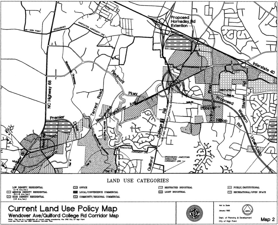
18 The Plan Increasing Density of Future Residential Development The corridor's interior, which was largely rural residential in character in 1989, is also experiencing rapid development, especially west of Guilford College Road, as noted earlier. The former Camp Uwharrie Boy Scout property is developing with a mixture of high-, medium- and low-density residential uses as well as neighborhood commercial and service uses. A low-density residential subdivision is currently under construction east of Penny Road on the south side of Wendover Avenue, and two medium-density residential projects have been approved north of Wendover Avenue near Tarrant Road. These recent land use changes are reflected on Map 2, Current Land Use Policy Map, with a description of the land use classifications listed in the Appendix. They demonstrate that there will eventually be more people living in the West Wendover Avenue Corridor than initially thought, and with a higher population density, it may be possible to establish alternative transportation modes as an option in the corridor. Additional neighborhood commercial, office uses and public facilities, including neighborhood recreation facilities east of Guilford College Road, may be required to serve this population, as will a fire station. Property for a fire station north of Wendover Avenue near Morris Farm Drive has been obtained by the city of High Point. As development occurs, though, it should be recognized that established low-density residential neighborhoods along Morris Farm Drive, Verdun Drive, Brewster Drive and Devoncourt Place are already in place, and care should be exercised to protect them. OBJECTIVES 1. To avoid strip development along Guilford College Road and West Wendover Avenue. 2. To concentrate community/regional commercial uses at each end of the corridor, specifically at the I-40/Wendover and N.C. Highway 68/Wendover intersections, and to focus residential, neighborhood commercial, and office/institutional uses near the intersection of Guilford College Road, West Wendover Avenue and Greensboro's Western Loop. 3. To preserve the existing low-density residential areas along Hilltop Road and Guilford College Road and to respect their character. 4. To encourage the conservation of existing neighborhoods and to protect them from intrusive development. 5. To accommodate higher density residential development, especially north of West Wendover Avenue and outside of the Watershed Critical Area, in specified locations. 6. To acquire additional park land for active recreation use. 7. To protect historic and cultural resource such as the Deep River Friends Meeting. Page 13

19 The Plan RECOMMENDATIONS Following are the major land use changes that have occurred since 1989 and that are recommended in the future for the West Wendover Avenue/Guilford College Road Corridor. These changes are based on the land use objectives and recent development trends. They are illustrated on Map 3, Future Land Use Map. A description of the land use classifications is given on page 28 in the Appendix. 1. Area 1 - From Community/Regional Commercial to Office. This change will ensure a harmonious relationship between new development and the Deep River Friend's Meeting property. The area projected is approximately 16 acres in the southwest quadrant of the intersection of West Wendover Avenue and Penny Road. 2. Area 2 - From Low-Density Residential to High-Density Residential. High-density residential development (greater than eight dwelling units per acre) here will provide a transition between the more intensive commercial and office uses to the west and the low-density residential (between one and five dwelling units per acre) and medium-density residential (between five and eight dwelling units per acre) uses to the east. The area projected is approximately 60 acres, 30 acres on each side of West Wendover Avenue east of Penny Road. 3. Area 3 - From Low- and Medium-Density Residential to Restricted industrial. This area reflects a 1994 rezoning to Conditional Use Light Industrial in Piedmont Centre. The area is approximately 44 acres at the intersection of West Wendover Avenue and Premier Drive. 4. Area 4 - From Low-Density Residential to Medium-Density Residential. This area reflects two recently approved multi-family and townhouse developments--river View Townhomes and Deep River Apartments--in the area. These developments will total more than 50 acres. About 87 additional acres north of West Wendover Avenue, from just west of Wintergreen Court to the open space area along Long Branch, for medium-density residential use is projected. 5. Area 5A - From Low-Density Residential to High-Density Residential. Approximately 38 acres west of Hickory Grove Road is projected for high-density residential development. This land use will be compatible with the high-density residential and commercial uses on the south side of West Wendover Avenue. 6. Area 5B - From Low-Density Residential to Office. Approximately 15 acres east of Hickory Grove Road is designated for office use due to the proximity to other proposed office developments and the proposed realignment of Guilford College Road at the West Wendover Avenue interchange. Page 14

20
21
22 The Plan 7. Area 6 - From Low-Density Residential to Office. This approximately 12 acre area is projected for office use because it will generally be surrounded by West Wendover Avenue to the south, Hickory Grove Road to the west, and future Piedmont Parkway to the east. 8. Area 7 - From Low-Density Residential to High-Density Residential. Given the magnitude of the intersection of Guilford College Road and Greensboro's Western Loop, this designation seems the most appropriate residential use in the intersection's northwest quadrant, particularly since the area is bordered by a quarry to the west and existing apartment developments to the northeast. Approximately 35 acres are projected. 9. Area 8 - From Low-Density and Medium-Density Residential to High- Density Residential. This change reflects the uses proposed as part of the Planned Unit Development zoning district approved for the former Camp Uwharrie Boy Scout property. Forty-seven acres are projected for high-density residential use. 10. Area 9 - From Low-Density Residential to Office. Low-density residential development here is unlikely, and office uses are more appropriate in this location than commercial uses due to a lessor impact on traffic circulation at this future mega-intersection. Approximately 22 acres in the southwest quadrant of the intersection of West Wendover Avenue and Guilford College Road are projected for office use. 11. Area 10 - Remaining mainly Low-Density Residential with a portion to Local/Convenience Commercial and Office. The area covers about 36 acres west of Guilford Road on either side of Piedmont Parkway at Hilltop Road. Local/convenience commercial development is proposed for 8 acres north of Piedmont Parkway and one acre south of Piedmont Parkway. This area is expected to serve the surrounding residential areas. Nearly 5 acres of office development is projected for an area north of Piedmont Parkway, which is intended as a buffer between the existing homes on Devoncourt Place and the proposed commercial uses. The 22 acre area between Piedmont Parkway and Akela Trail is recommended to remain low-density residential, consistent with the existing neighborhoods. 12. Area 11 - From Medium-Density Residential to Public/Institutional. A church is anticipated to be constructed on this 12 acre site in the northwest quadrant of Bridford Parkway and Hilltop Road. 13. Area 12 - From Medium- to High-Density Residential. This designation reflects a 1994 rezoning and includes about 105 acres. A new, multi-family development, Abbington Place, is presently under construction south of this area. 14. Area 13 - From Light Industrial to Community/Regional Commercial. This change reflects development trends in the vicinity and, it is hoped, will fulfill the demand for additional commercial space at the Interstate 40/Wendover Avenue commercial node. Projected are approximately 64 acres in the northwest quadrant of the intersection of Wendover Avenue and Bridford Parkway. Page 15
23 The Plan ENVIRONMENTAL FACTORS ISSUES Watershed Considerations The vast majority of the West Wendover Avenue corridor in High Point's current and future jurisdiction lies within the High Point City Lake watershed, with a small area to the southeast of the West Wendover Avenue/N.C. Highway 68 intersection lying in High Point's Oak Hollow Lake watershed. Most of the corridor is in the General Watershed Area (GWA) of High Point City Lake, but the area between Morris Farm Drive and a point approximately 4,000 feet to the west (south of Wendover Avenue only) is in Tier 4 of the lake's Watershed Critical Area (WCA) (see Map 4, Watershed Boundaries and Greenway Map). The watershed is classified by the North Carolina Environmental Management Commission as a WS-IV drinking water supply watershed, and High Point's Development Ordinance places limits on development on all affected properties. Land in the corridor between Guilford College Road and Bridford Parkway lies in the watershed of the proposed Randleman Dam, which will provide drinking water for Greensboro, High Point and other cities in the region. It is assumed that the watershed will be classified as WS-IV when the facility is completed, and it is being protected as such by Greensboro and Guilford County. Most of the land surrounding the Interstate 40/West Wendover Avenue interchange is not located within a designated drinking water supply watershed. As low-density residential uses usually have a smaller amount of built-upon area relative to lot size than other types of development, low-density residential development is often viewed as the most appropriate for a drinking water watershed. On the other hand, efficient land use requires that jobs and needed goods and services be located reasonably close to residential areas. Therefore, even though lowdensity residential will remain the predominant land use in the broader West Wendover Avenue/Guilford College Road study area, other uses need to be accommodated. Greenways Greenways are linear parks and are frequently located in floodplains along streams. As such, they serve an important environmental function by preventing construction on unsuitable land, by buffering streams, and by absorbing stormwater runoff. Greenways preserve vegetation and provide wildlife habitat; and if a trail is constructed in a greenway, recreation and transportation purposes will also be served. Guilford County's Bicentennial Greenway crosses West Wendover Avenue near Tarrant Road and ends at City Lake south of the Piedmont Environmental Center. Just north of Wendover Avenue along the greenway is an important environmental asset of the study area--a stand of Mountain Laurel adjacent to the Deep River, on which the county holds a scenic easement (see Map 4). One additional greenway is Page 16
24
25 The Plan proposed to follow the Long Branch creek, starting approximately 1,500 feet south of West Wendover Avenue, and ending at the Bicentennial Greenway along the Deep River (see Map 4). This greenway will provide neighborhood access to the larger Guilford County/High Point greenway system. OBJECTIVES 1. To protect drinking water supply watersheds. 2. To ensure an adequate amount of open space is maintained. 3. To protect flood plains and environmentally sensitive lands. 4. To preserve existing vegetation where possible and to replace removed vegetation where necessary. 5. To expand the greenway trail system. RECOMMENDATION Land along Long Branch should be acquired for a greenway, beginning approximately 1,500 feet south of West Wendover Avenue to the Bicentennial Greenway along the Deep River (see Map 4). VISUAL QUALITY ISSUES The West Wendover Avenue/Guilford College Road Corridor is an important and exceptionally visible gateway between Greensboro, High Point and Jamestown. Commuters, visitors and residents experience it as they enter the cities from Interstate 40, the Piedmont Triad International Airport and the surrounding area. The public interest can best be served if that visual experience is a pleasant one. Visual quality in land development is usually enhanced through three avenues: buffering and landscaping requirements; sign control; and development standards or design guidelines. Page 17
26 The Plan Buffering and Landscaping Requirements Generous buffer setbacks from property lines reduce the apparent mass of buildings and allow for the retention of existing vegetation and the planting of new landscaping. It is usually desirable for existing native vegetation to be retained where possible, especially when mature or specimen (outstanding examples of highly desirable species) trees or shrubs are present. As natives of the area, these trees and shrubs are normally less prone to disease and are easier to care for than exotics. They are also generally much larger in size than plant materials obtained from nurseries. A corridor lined with mature, native plant materials achieves a visual continuity. When a need exists to supplement existing plant materials with purchased materials, they should be of sufficient size to provide an effective buffer in a reasonable time and to fulfill other purposes of the landscape ordinance, such as the screening of parking areas and dumpster sites. Sign Control The control of signage is critical in promoting visual quality. When visual clutter is reduced through fewer and smaller signs, individual signs are easier to identify and read. Stronger guidelines regarding the height, size, location, and type of signs in the West Wendover Avenue/Guilford College Road Corridor are suggested in the Appendix. Development Standards/Design Guidelines Standards and design guidelines for the development of property should enhance the aesthetic quality of developments, make the individual components of a development compatible with each other, and encourage visual harmony between nearby developments and the natural environment. At the same time, the standards should allow for flexibility so that creative design will not be stifled. Successful developments throughout the country derive their appeal through high-quality design standards. Topics typically addressed by development standards and guidelines include roof pitch, exterior building materials, color, awnings, and building height and orientation, among others. OBJECTIVE To ensure the maintenance of a high visual quality in the Wendover Avenue Corridor with appropriate standards for signs, landscaping, buffer yards, setbacks and design guidelines. Page 18
27 The Plan RECOMMENDATION A West Wendover Avenue Scenic Corridor Overlay Zoning District should be established and incorporated into the Development Ordinances of Guilford County, Greensboro and High Point. Standards for signage, landscaping and design suggested for inclusion in a future Scenic Corridor Overlay Zoning District are detailed in the Appendix. Page 19
28
29 Appendix APPENDIX TRANSPORTATION STANDARDS Access Requirements If any street other than West Wendover Avenue is available for access to any parcel with frontage on West Wendover Avenue, access shall be taken from the alternate street. Subsequent property subdivision should not increase the number of access points on a given segment of West Wendover Avenue. All access points are subject to review by local and state Departments of Transportation. Service Drives Increasing the density of residential development between Premier Drive and Guilford College Road will increase the number of vehicular trips on West Wendover Avenue. These trips may increase to a point where additional median crossings may be desired for vehicles wishing to make left-turns onto Wendover Avenue, rather than making right-turns onto Wendover Avenue and then attempting unsafe u-turns at the first available median crossing. Additional median crossings will increase interruptions in traffic flows, thereby reducing the carrying capacity of Wendover Avenue. To alleviate the pressure for additional median crossings, a system of public streets and service drives is recommended so that all residential and office developments along the frontage of this segment of Wendover Avenue will be channeled to an existing median crossing. As future development occurs, the service drives will be linked through crosseasements. Each development will be responsible for constructing its link of the service drive or public street. Service drives may either be public or private depending upon the size and type of development and the overall traffic impact on surrounding streets. A concept plan depicting the location of these service drives is shown in the Future Street Concept Plan on Maps A1-A5 and will serve as an internal street plan to be implemented in subsequent rezoning requests and development proposals. This plan has been prepared in collaboration with the High Point Department of Transportation. Topography has been taken into account in projecting the location of these service drives so that construction costs will be reduced. The general location of future public residential streets between West Wendover Avenue and future Piedmont Parkway (such as Morris Farm Drive) have also been shown, as has a service road concept for the office and commercial uses proposed surrounding the Piedmont Parkway and Guilford College Road intersection. Page 21
30 Appendix Location and Spacing of Access (See also the following exhibit.) No driveways except those serving individual single-family residential lots shall be allowed along West Wendover Avenue within 500 feet of the centerline of an intersecting major street, which is defined as any intersecting street for which a median opening is provided. No driveways except those serving individual singlefamily residential lots shall be allowed along an intersecting street within 200 feet of the centerline of West Wendover Avenue. No driveways except those serving individual single-family lots shall be allowed along West Wendover Avenue within 200 feet of the centerline of an intersecting minor street, which is defined as any intersecting street for which no median opening on Wendover Avenue is provided. No driveways except those serving individual single-family residential lots shall be allowed along an intersecting minor street within 200 feet of the centerline of West Wendover Avenue. No driveways except those serving individual single-family lots shall be allowed along Guilford College Road between Hickory Grove Road located north of West Wendover Avenue and Ruffin Road located to the south of West Wendover Avenue. Side Clearance No driveways except those serving individual single-family residential lots shall be allowed within 30 feet of the side property line of any property except where a mutual joint access agreement exists between adjoining owners. Spacing The distance between two non-residential driveways shall be a minimum of 400 feet measured from each driveway's centerline. Page 22
31
32
33
34
35
36
37
38 Appendix TRAFFIC IMPACT ANALYSIS REQUIREMENTS Definition A Traffic Impact Analysis (TIA) is a process used by transportation planners and traffic engineers to determine and describe how traffic generated by new or replacement development will be served by an existing or future road network. These studies are generally performed for the following reasons: 1) To ascertain the ability of the street system to absorb traffic generated by the proposed development; 2) To identify any degradation of traffic flow and level of service; 3) To address any problems created through analysis of transportation alternatives; and 4) To ensure that adequate access for traffic generated is provided to each site. Minimum Standards A Traffic Impact Analysis shall be performed by a professional transportation consulting firm registered in the state of North Carolina and familiar with the standard practices and procedures of Traffic Impact Analysis. When Required As noted in the body of this plan, when an application is made for access to West Wendover Avenue, a TIA will be requested in the following instances: 1. Whenever a development will generate 200 or more additional peak direction (inbound or outbound) trips to or from the site during the adjacent roadway's peak hour or the development's peak hour; or 2. When the peak hour of traffic generation will exceed a threshold of 100 vehicles per hour and other localized safety or capacity deficiencies exist, such as: a) Current traffic volume or traffic safety problems in the local area; b) Current or projected level of service of the roadway system adjacent to the development will be significantly affected; or c) Adjacent neighborhoods or other sensitive areas may be perceived as being impacted. Page 23
39 Appendix Required Elements A Traffic Impact Analysis shall be in the form of a written report and shall include the following elements: 1. Study purpose and objectives; 2. Description of the site and study area including rationale for selection of the actual study boundaries; 3. Existing conditions in the area of the development including general street/roadway traffic volumes and capacities, key intersections' capacities, safety deficiencies, and planned or funded transportation improvements; 4. Anticipated/approved development in the area; 5. Trip generation, trip distribution, and modal split, including: a) Source of trip generation rate and assumptions for any variations from normally recognized generation rates; b) The passby factor and assumptions used in the selection of this factor; c) The assumptions made concerning internal trips for mixed use development; and d) Assumptions for trip distribution; 6. Projected future traffic volumes; 7. An assessment of the change in roadway operating conditions resulting from the development traffic; and 8. Recommendations for site access and transportation improvements needed to maintain traffic flow to, from, within and adjacent to the site at an acceptable and safe level of service (generally assumed at Level of Service "D"). Page 24
40 Appendix SIGN REQUIREMENTS Excess signage can contribute to visual clutter and a poor aesthetic quality in a road corridor. In addition, unrestricted signage can create dangerous driving conditions as drivers search among a welter of signs for the one designating their destination. Because a high aesthetic quality is one of the chief aims of this updated Wendover Avenue Corridor Plan, it is suggested that the following signage requirements described below be implemented: ATTACHED SUGGESTED SIGNAGE REQUIREMENTS Number Permitted: Maximum Area: Maximum Height: 1/wall 7.5% of wall area not to exceed 100 sq. ft. top of wall FREESTANDING Number Permitted: Setback: Height: Maximum Area: 1/frontage ROW 6' for lots with less than 200' of street frontage; for lots exceeding 200' of frontage, height shall be a 20' possible maximum. 50 sq. ft. for single businesses; 90 sq. ft. for group developments < 25,000 sq. ft.; 135 sq. ft. for group developments > 25,000 Page 25
41 Appendix The following sign requirements are also suggested in the West Wendover Avenue Corridor: 1. The following signs shall be prohibited: Changeable copy signs (message boards), except for fuel pricing and church identification signs; Animated signs, including electronic changeable copy signs, except for time and temperature signs which do not exceed 15 square feet of copy area; Ground surface signs; and Posters 2. Church identification signs shall display only the church name, service hours and church-related events. 3. Freestanding signs shall display only the name, trademark, registered logo, or vehicular fuel prices. LANDSCAPING REQUIREMENTS Landscaping standards described below should be implemented in the corridor: SUGGESTED LANDSCAPING STANDARDS Minimum trees required within survey area: Minimum tree size: Minimum shrubs required within survey area: 1/25 sq. ft cal. 17/100 l. ft. Minimum shrub size: 30 Interior parking landscape requirements: Minimum street yard width: Min. parking lot setback: 1 tree in island/12 spaces (min. 200 sq. ft. island area) 40 ft. average 30 ft. minimum Page 26
42 Appendix 1. Tree preservation within required planting yards shall be required where feasible using the following criteria: Tree specimens and size; Health of the tree; Whether the location of the tree prevents all reasonable access to the property; Whether the location of the tree prevents the construction of utility lines or drainage facilities; Whether the location of the tree precludes all reasonable use of the property; Impact of tree on health of remaining trees; or The tree enhances the streetscape appearance. 2. Watershed detention ponds shall be screened with landscaping so as to obscure to the maximum extent feasible view from public rights-of-way. DEVELOPMENT DESIGN REQUIREMENTS Site design in the West Wendover Avenue/Guilford College Road study area would be best addressed through the establishment of a Scenic Corridor Overlay Zoning District. The outline of what such a district could require is presented below. Architecture Metal and vertical-sided buildings, which include but are not limited to buildings sided with vinyl and masonite, and which are visible from the West Wendover Avenue right-of-way should be prohibited unless building plans and elevations are submitted to the appropriate jurisdiction for review and approval. Decorative landscaping or screening should be installed to screen from view to the extent possible unsightly building appurtenances from public rights-of-way. Multi-tenant developments should submit design guidelines addressing the following criteria: 1. A common signage plan, including location, copy, illumination, height, materials, and colors; 2. Exterior building materials and colors, including examples of materials and colors to be consistent throughout the development; Page 27
43 Appendix 3. Facade design; and 4. Common landscaping scheme, including street yards and peripheral plantings, parking area plantings, and tree preservation. LAND USE CLASSIFICATIONS Map 3 shows proposed land uses in the Wendover Avenue/Guilford College Road Study Area. The land use classifications included on the map are described below: Low-Density Residential: These areas include primarily single-family detached dwellings on individual lots. Development densities in these areas will not exceed five dwelling units per acre. Medium-Density Residential: This classification includes a variety of detached or attached dwellings, including single-family homes, duplexes, townhouses, or apartments. Development densities range from five to eight units per acre. High-Density Residential: High-density residential includes all types of landintensive housing. Development densities are greater than eight units per acre. Office: This classification includes professional, personal and business services. Local/Convenience Commercial: This classification includes moderate-intensity convenience retail or service uses, generally serving small, local neighborhoods. Community/Regional Commercial: This classification includes a wider range of retail or service uses intended to serve the entire community and nearby regional consumers. Restricted Industrial: This classification accommodates office, warehouse, research and development, distribution, and light manufacturing or assembly uses on larger sites in unified developments. Light Industrial: Light industrial areas include general manufacturing, wholesaling, warehousing, and research and development uses. Public/Institutional: Public, quasi-public, and institutional uses on large tracts are included in this classification. Recreation/Open Space: Lands for recreation or open space are included in this classification, offering either active uses or passive use and environmental protection. Page 28
44 City of High Point Department of Planning and Development P.O. Box 230 High Point, NC (910) TDD # (910)
Goals & Objectives. Chapter 9. Transportation
 Goals & Objectives Chapter 9 Transportation Transportation MISSION STATEMENT: TO PROVIDE A TRANSPORTATION NETWORK CAPABLE OF MOVING PEOPLE AND GOODS EFFICIENTLY AND SAFELY. T he transportation system
Corridor Goals and Objectives
 Corridor Goals and Objectives This chapter presents the goals and objectives, developed by the Corridor Study Committee, that serve as the purpose and intent of the Corridor Plan. This plan covers a twenty
FILE NO.: Z-6915-C. Gamble Road Short-form PCD and Land Alteration Variance Request
 FILE NO.: Z-6915-C NAME: Gamble Road Short-form PCD and Land Alteration Variance Request LOCATION: Located on the Northwest corner of Chenal Parkway and Gamble Road DEVELOPER: Davis Properties P.O. Box
SACRAMENTO COUNTY SUMMARY OF ZONING CLASSIFICATIONS
 SACRAMENTO COUNTY SUMMARY OF ZONING CLASSIFICATIONS This document provides a brief overview of zoning designations only. Inaccuracies may be present. Please consult the Sacramento County Zoning Code for
AREA: 2.37 acres NUMBER OF LOTS: 1 FT. NEW STREET: 0 LF. Single-family, Non-conforming machine shop
 FILE NO.: Z-8958 NAME: Rock Structure Repair Short-form PID LOCATION: Located at 8024 Stanton Road DEVELOPER: Rock Structure Repair Attn. Rudy Gutierrez 3 Kipling Court Little Rock, AR 72209 ENGINEER:
Rezoning case no. RZ15-08: Adam Development Properties, LP
 PLANNING AND ZONING COMMISSION STAFF REPORT June 4, 2015 Rezoning case no. RZ15-08: Adam Development Properties, LP CASE DESCRIPTION: LOCATION: a request to amend the development plan of a previously-approved
Industrial Suburban District Regulations City of St. Petersburg City Code Chapter 16, Land Development Regulations
 16.20.110 - Industrial Suburban District ( IS ) Figure REFERENCE Typical Buildings in the IS District Figure REFERENCE Site Plan of a typical development in the IS District Sections: 16.20.110.1 Composition
Chapter 7 ZONING PLAN
 Chapter 7 ZONING PLAN Introduction This Chapter opens with a general description of a zoning plan. It is followed by a brief explanation of the relationship between this Growth Management Plan and the
WESTFIELD-WASHINGTON ADVISORY PLAN COMMISSION December 7, 2015 1512-SPP-24 & 1512-ODP-24
 Petition Number: Subject Site Address: Petitioner: Request: East side of Oak Road, north of 151 st Street Langston Development Co. Primary Plat and Overall Development Plan amendment review for Mapleridge
Revere Beach Transit-Oriented Development Parcels Revere, Massachusetts. Design and Development Guidelines. Part Two.
 Revere Beach Transit-Oriented Development Parcels Revere, Massachusetts Design and Development Guidelines Request for Qualifications and Expressions of Interest with Preliminary Development Plans Part
12 February 8, 2012 Public Hearing APPLICANT:
 12 February 8, 2012 Public Hearing APPLICANT: PROPERTY OWNER: VIRGINIA BEACH ASSOCIATES, LC REQUEST: Conditional Change of Zoning (I-1 to Conditional A-36) STAFF PLANNER: Faith Christie ADDRESS / DESCRIPTION:
INTRODUCTION TO ZONING DISTRICT REGULATIONS
 INTRODUCTION TO ZONING DISTRICT REGULATIONS Classification of Zoning Districts Zoning districts in Dorchester County are categorized as Suburban Urban, Suburban Transition, or Rural. These districts are
Restoration. a brief look at
 Copyright 2009 Canin Associates, Inc. All rights reserved. No part of this publication may be reproduced or transmitted by any means without written permission from Canin Associates, Inc. a brief look
Kirkland Zoning Code 113.25
 Kirkland Zoning Code 113.25 Chapter 113 COTTAGE, CARRIAGE AND TWO/THREE-UNIT HOMES Sections: 113.05 User Guide 113.10 Voluntary Provisions and Intent 113.15 Housing Types Defined 113.20 Applicable Use
d. Building permits may only be approved if consistent with the approved development plan and land division for all units with common walls.
 Section 20.920.060 Tier 2 Infill Standards. In addition to the Tier 1 standards and incentives, Tier 2 infill parcels and land divisions and the subsequent development on those Tier 2 infill parcels shall
 Walkable Communities Florida Department of Transportation State Safety Office Pedestrian and Bicycle Program April 1995 www.dot.state.fl.us/safety Twelve Steps for an Effective Program Page 1 Twelve Steps
Zoning Districts, Gwinnett County, Georgia
 Zoning Districts, Gwinnett County, Georgia The zoning district descriptions in this section should be used as a guide only for the unincorporated areas of Gwinnett County. Before buying or selling property,
28.0 Development Permit Area #2 (Neighbourhood District)
") 28.0 Development Permit Area #2 (Neighbourhood District) Goals and Objectives To provide a guide for infill and new development in the Neighbourhood District. To outline the nature, form and character
28.0 Development Permit Area #2 (Neighbourhood District) Goals and Objectives To provide a guide for infill and new development in the Neighbourhood District. To outline the nature, form and character
Topic 2 11/28/2012 Blocks & Street Network
 TOPIC 2 Blocks & Street Network Implementation Note: 1. Some recommendations are summarized in the tables herein. For complete recommendation language, please see the. 2. Recommendations referenced in
SANTA BARBARA COUNTY COMPREHENSIVE PLAN LOMPOC AREA
 SANTA BARBARA COUNTY COMPREHENSIVE PLAN LOMPOC AREA A. LAND USE ELEMENT INTERPRETIVE GUIDELINES B. COMMUNITY BENEFITS C. COUNTY ACTION ITEMS Adopted by the Board of Supervisors November 9, 1999 A. Santa
TOWN OF CARY CONDITIONAL USE ZONING PERMIT. 412 Rutherglen Cary, NC 27511-6437. 412 Rutherglen Cary, NC 27511-6437
 TOWN OF CARY CONDITIONAL USE ZONING PERMIT PETITION: PETITIONER(S): OWNER(S): LOCATION: 01-REZ-16 204 N. Dixon Avenue, Cary, NC PARCEL IDENTIFICATION: 076418218784 REALID: 0031004 AREA: APPROVED ZONING:
FILE NO.: Z-8403. LOCATION: Located on the Northeast and Southeast corners of West 12 th Street and Dennison Street
 FILE NO.: Z-8403 NAME: Glason Short-form POD LOCATION: Located on the Northeast and Southeast corners of West 12 th Street and Dennison Street DEVELOPER: Dennis Glason c/o the Law Office of Simmons S.
5 March 12, 2014 Public Hearing
 5 March 12, 2014 Public Hearing APPLICANT: MOORE FARM, L.L.L.P. PROPERTY OWNER: MOORE FARM L.L.L.P. STAFF PLANNER: Kevin Kemp REQUEST: Change of Zoning (B-1A Limited Community Business to Conditional B-2
D3 April 8, 2015 Public Hearing
 D3 April 8, 2015 Public Hearing APPLICANT AND PROPERTY OWNER: ASSEMBLY OF YAH, INC. STAFF PLANNER: Kevin Kemp REQUEST: Conditional Use Permit (Religious Facility - church) ADDRESS / DESCRIPTION: 5151 Locke
7.0 INTRODUCTION 7.1 BACKGROUND
 Section 7: Economic Development 7.0 INTRODUCTION A community s character is a function of its residential neighborhoods, its open spaces, and its commercial districts. Commercial uses also play another
City of Valdosta Land Development Regulations. Table of Contents
 TITLE 1 ADMINISTRATION Chapter 102 General Provisions 102-1 Title 102-2 Purpose 102-3 Authority 102-4 Jurisdiction 102-5 Application of Ordinance 102-6 Relationship to Existing Ordinances 102-7 Powers
APPENDIX F RIGHTS-OF-WAY PRESERVATION GUIDELINES
 Los Angeles County Metropolitan Transportation Authority (Metro) 2009 Transportation Improvement Program Call for Projects APPENDIX F RIGHTS-OF-WAY PRESERVATION GUIDELINES Los Angeles County Metropolitan
COUNTY OF ALBEMARLE PLANNING STAFF REPORT SUMMARY. Staff: Claudette Grant
 COUNTY OF ALBEMARLE PLANNING STAFF REPORT SUMMARY Project Name: ZMA 2013-00004 Hollymead Town Center Block VI Planning Commission Public Hearing: July 29, 2014 Staff: Claudette Grant Board of Supervisors
Opal Service District Plan
 8 The Opal Service District includes a variety of planned land uses including commercial, mixed-use, flex office, industrial, and hospitality. This Plan seeks to simplify the land use categories to allow
STATEMENT OF PURPOSE
 STATEMENT OF PURPOSE Community Properties, Inc. ( CPI ) is applying to Chatham County for approval of a major subdivision, Meadowview PUD (the Project ), with access to NC 87 and Old Graham Road, just
REPORT OF THE PLANNING AND DEVELOPMENT DEPARTMENT FOR APPLICATION FOR REZONING ORDINANCE 2015-0183 TO PLANNED UNIT DEVELOPMENT APRIL 9, 2015
 AWH REPORT OF THE PLANNING AND DEVELOPMENT DEPARTMENT FOR APPLICATION FOR REZONING ORDINANCE 2015-0183 TO PLANNED UNIT DEVELOPMENT APRIL 9, 2015 The Planning and Development Department hereby forwards
Texas Case Studies in Access Management. Ed Hard, TTI
 Texas Case Studies in Access Management Ed Hard, TTI 8 th National Conference on Access Management August 15, 2006 Presentation Overview TxDOT Arterial Widenings, College Station, TX Processes for Median
Site Deliverability Statement Development at: Beech Lane, Kislingbury. Persimmon Homes Midlands March 2015
 Site Deliverability Statement Development at: Beech Lane, Kislingbury Persimmon Homes Midlands March 2015 Contents Site Deliverability Statement Development at: Beech Lane, Kislingbury 1.INTRODUCTION 1.1
Tier 1 Strategies. WV Route 14 Corridor Management Plan
 1.1 1.2 1.3 1.4 Signal timing optimization system improvements. Improve geometry traffic control at high crash intersections. Construct intersection capacity improvement projects. Widen longer sections
January 25, 2005. Ivest Associates c/o Stanhope Johnson P. O. Box 9905 Greensboro, NC 27030 RE: ZONING MAP AMENDMENT W-2747. Dear Mr.
 GAMBLE DR 730 January 25, 2005 Ivest Associates c/o Stanhope Johnson P. O. Box 9905 Greensboro, NC 27030 RE: ZONING MAP AMENDMENT W-2747 Dear Mr. Johnson: The attached report of the Planning Board to the
Preliminary Plan Application and Checklist
 ALL APPLICATIONS ARE DUE AT 12:00 NOON ON THE FILING DATE Office Use Only PRELIMINARY / REVISED PRELIMINARY PLAN $300.00 Fee Paid: $ Date Paid: ALL FIELDS HIGHLIGHTED IN RED ARE REQUIRED FIELDS Case No.:
PLANNING DIVISION STAFF REPORT February 23, 2015. Summary. Background Information PREPARED FOR THE PLAN COMMISSION. Legistar File ID # 36810
 PLANNING DIVISION STAFF REPORT PREPARED FOR THE PLAN COMMISSION Project Address: Application Type: Legistar File ID # 36810 Prepared By: Summary Conditional Use Timothy M. Parks, Planning Division Report
PLANNING FOR NEW DEVELOPMENT AT THE COTTONWOOD MALL SITE
 APPENDIX F PLANNING FOR NEW DEVELOPMENT AT THE COTTONWOOD MALL SITE Table of Contents The Setting Background Planning Objectives Neighborhood Protection The Concept Plan Exhibits Cottonwood Mall Site 1
Adopted Keystone Odessa Community Plan
 Adopted Keystone Odessa Community Plan Effective January 2001 Staff has done an initial assessment of the adopted community and has highlighted: in blue those strategies which called for specific actions
How To Improve Service In Arundel
 Draft of Economic Development Strategy - Town of Arundel Chapter 3.3 - Infrastructure, Transportation and Zoning 1. Infrastructure The lack of infrastructure in Arundel could present significant problems
PROFFER STATEMENT REZONING TLZM 2013-0001 LEEGATE November 1, 2013
 PROFFER STATEMENT REZONING TLZM 2013-0001 LEEGATE November 1, 2013 Leegate LLC and Stanley Martin Companies, LLC, owner and applicant, (the Applicant ) of certain property described as Loudoun County Tax
1161.01 CONFORMITY WITH PLANS; DRAINAGE.
 CHAPTER 1161 Subdivision Requirements 1161.01 Conformity with plans; drainage 1161.07 Easements 1161.02 Trees 1161.08 Streets 1161.03 Subdivision name 1161.09 Blocks 1161.04 Street names 1161.10 Lots 1161.05
Fast Track A Successful Redevelopment: The Palm Beach Outlets Story
 Fast Track A Successful Redevelopment: The Palm Beach Outlets Story SPEAKERS Rick Greene, AICP City of West Palm Beach Brian Seymour, Esq. Gunster Ken Tuma, PE UDKS Josh Long, AICP Gunster Grand Opening
Staff Report General Development Plan/Master Plan Aldermanic District: 1 County Commission District: 2 MPC File No. 16-000526-PLAN February 23, 2016
 Staff Report General Development Plan/Master Plan Aldermanic District: 1 County Commission District: 2 MPC File No. 16-000526-PLAN February 23, 2016 1101 Bull Street One West Park Avenue 1107 Bull Street
Draft Goals and Objectives Wadena Comprehensive Plan City of Wadena, Minnesota. Land Use Goals:
 Draft Goals and Objectives Wadena Comprehensive Plan City of Wadena, Minnesota Land Use Goals: 1. Growth in Wadena will be undertaken in such a manner as to create a full range of living, working, shopping,
HARRIS TEETER AT LADY S ISLAND CITY OF BEAUFORT DRB CONCEPTUAL PROJECT NARRATIVE Submittal Date: September 2, 2015 Meeting Date: September 10, 2015
 HARRIS TEETER AT LADY S ISLAND CITY OF BEAUFORT DRB CONCEPTUAL PROJECT NARRATIVE Submittal Date: September 2, 2015 Meeting Date: September 10, 2015 PROPOSED REDEVELOPMENT The project consists of demolishing
AREA: 0.16 acres NUMBER OF LOTS: 1 FT. NEW STREET: 0 LF
 FILE NO.: Z-9020 NAME: Hometown Tax Service Short-form PD-O LOCATION: Located at 3008 West 12 th Street DEVELOPER: Mark Green 65 Westfield Loop Little Rock, AR 72210 SURVEYOR: Kittler-Roberts Group, LLP
CITY COUNCIL PACKET MEMORANDUM
 CITY COUNCIL PACKET MEMORANDUM DOCUMENT: Final Plan and Final Plat SUBJECT: City Center Lenexa The Domain at City Center CONTACT PERSON: Beccy Yocham, Director of Community Development DATE: December 3,
City of Tampa Zoning Districts
 City of Tampa Zoning Districts The city is divided by chapter 2 into zoning districts, the boundaries and designations of which are shown in a series of maps, covering in combination the entire land and
BLOCK 400 PLANNED COMMUNITY DISTRICT
 BLOCK 400 PLANNED COMMUNITY DISTRICT Newport Center December 1983 Newport Beach, California Ordinance 88-119 Adopted December 12, 1988 Amendment No. 672 Resolution No. 95-115 Adopted October 9, 1995 Amendment
TOWN BOARD OF THE TOWN OF NORTH SALEM WESTCHESTER COUNTY, NEW YORK LOCAL LAW # OF THE YEAR 2012
 TOWN BOARD OF THE TOWN OF NORTH SALEM WESTCHESTER COUNTY, NEW YORK LOCAL LAW # OF THE YEAR 2012 CHAPTER 250, ZONING ORDINANCE AMENDMENTS - PD-CCRC DISTRICT Section 1. Purpose: The purpose of this Local
1.7.0 Floodplain Modification Criteria
 1.7.0 Floodplain Modification Criteria 1.7.1 Introduction These guidelines set out standards for evaluating and processing proposed modifications of the 100- year floodplain with the following objectives:
How To Amend A Stormwater Ordinance
 Regulatory Alternatives to Address Stormwater Management and Flooding in the Marlboro Street Study Area Alternative 1: Amend Existing Local Regulations This proposed alternative provides an incremental
1. Land Use. Chapter 1: Land Use 1-1 Adopted 10/2/09 Amended 3/22/11, 8/16/11
 1. Land Use Minneapolis will develop and maintain a land use pattern that strengthens the vitality, quality and urban character of its downtown core, commercial corridors, industrial areas, and neighborhoods
Land Use Element. Introduction 2.3. A Citywide Land Use Policies 2.3. A-1 The Future Land Use Map & the Location of Zones 2.3. A-2 Uses 2.
 Seattle s Comprehensive Plan Toward a Sustainable Seattle 2.1 Land Use Element Table of Contents Introduction 2.3 A Citywide Land Use Policies 2.3 A-1 The Future Land Use Map & the Location of Zones 2.3
3 September 9, 2015 Public Hearing
 3 September 9, 2015 Public Hearing APPLICANT: PI TELECOM INFRASTRUCTURE T, LLC PROPERTY OWNER: JSW HOLDINGS, LLC STAFF PLANNER: Carolyn A.K. Smith REQUEST: Conditional Use Permit (communications tower-monopole)
PLANNING COMMISSION REPORT Regular Agenda - Public Hearing Item
 Z-15-00063 Item No. 1-1 PLANNING COMMISSION REPORT Regular Agenda - Public Hearing Item PC Staff Report 04/20/2015 ITEM NO. 1 Z-15-00063 CS TO RS5; 832 Ohio Street (BJP) Z-15-00063: Consider a request
CITY OF WEST PALM BEACH ZONING BOARD OF APPEALS Meeting Date: February 6, 2014 Zoning Board of Appeals Case No. 3302
 CITY OF WEST PALM BEACH ZONING BOARD OF APPEALS Meeting Date: February 6, 2014 Zoning Board of Appeals Case No. 3302 1950 Golden Lakes Blvd. Class B Special Use Permit Location Aerial I. REQUEST Site is
Proposed Heavy Equipment (Nortrax) Sales & Service Facility
 Sales & Service Facility") Proposed Heavy Equipment (Nortrax) Sales & Service Facility 130 David Manchester Road Planning Rationale Prepared by: McIntosh Perry Consulting Engineers Ltd. 115 Walgreen Road Carp, ON K0A 1L0 July 2013
Proposed Heavy Equipment (Nortrax) Sales & Service Facility 130 David Manchester Road Planning Rationale Prepared by: McIntosh Perry Consulting Engineers Ltd. 115 Walgreen Road Carp, ON K0A 1L0 July 2013
PRELIMINARY PROJECT REVIEW PROCESS
 CITY OF CYPRESS 5275 Orange Avenue Cypress, California 90630 (714) 229-6720 PRELIMINARY PROJECT REVIEW PROCESS 1. Discuss project with Planning staff to determine zoning regulations, unusual characteristics
AD HOC GROUP ON A-FRAME & DIGITAL SIGNAGE
 City of Alexandria, Virginia AD HOC GROUP ON A-FRAME & DIGITAL SIGNAGE June 3, 2015 7:00 PM Alexandria s Signage Regulations Signs are regulated by the Zoning Ordinance First regulated in 1951 Most current
BEST PRACTICES. Smart Transportation is a key concept for the Paoli Roadway Improvement Project.
 Smart Transportation Smart Transportation is a key concept for the Paoli Roadway Improvement Project. PennDOT s Smart Transportation Guidebook (2008) outlines a comprehensive approach to transportation
TH 23 Access Management Study Richmond to Paynesville
 TH 23 Access Management Study Richmond to Paynesville Prepared For: Minnesota Department of Transportation District 8 Prepared By: Short Elliott Hendrickson Inc. July 2015 Table of Contents I. Introduction...
PLANNED UNIT DEVELOPMENT & SIDEWALK WAIVER REQUEST STAFF REPORT Date: November 7, 2013
 PLANNED UNIT DEVELOPMENT & SIDEWALK WAIVER REQUEST STAFF REPORT Date: November 7, 2013 NAME LOCATION Audubon Properties, LLC. 4700 & 4960 Dauphin Island Parkway West side of Dauphin Island Parkway, 580
B. Improve the appearance and character of areas surrounding new development.
 Chapter 4.3: Landscape Regulations Sections: 4.301 Purposes 4.302 Applicability 4.303 General Provisions 4.304 Landscape Maintenance 4.301 Purposes The purposes of these regulations are to: A. Promote
BASSETT CREEK VALLEY MASTER PLAN OPEN HOUSE
 BASSETT CREEK VALLEY MASTER PLAN OPEN HOUSE February 23, 2006 PROJECT INTRODUCTION Project Area 230 acres $50 million estimated market value (approximately) 50 acres parkland 100 residences (estimated)
TRANSPORTATION SERVICE STANDARDS ELEMENT GOALS, OBJECTIVES & POLICIES
 TRANSPORTATION SERVICE STANDARDS ELEMENT GOALS, OBJECTIVES & POLICIES Background One of the most critical public services provided by a community is the community s transportation system. An effective
A PPENDICES C OLLIERVILLE 2040 LAND USE PLAN UPDATE
 A PPENDICES C OLLIERVILLE 2040 LAND USE PLAN UPDATE Traditional Neighborhood Character Study with a Neighborhood Center Commercial Node Aldi s is appropriate in a Neighborhood Center School Greenbelt Trail
How To Plan A Buffer Zone
 Backyard Buffers Protecting Habitat and Water Quality What is a buffer? A buffer (also called a riparian buffer area or zone) is the strip of natural vegetation along the bank of a stream, lake or other
BEACON AVENUE URBAN RENEWAL PROJECT
 BEACON AVENUE URBAN RENEWAL PROJECT City of Jersey City Adopted May, 1976 Block and Lot Updates August 6, 2012 Amended September 13, 2012 DIVISION OF CITY PLANNING Beacon Avenue Urban Renewal Project Table
Transportation Policy and Design Strategies. Freight Intensive. Level of Freight Presence
 Appendix G Transportation Policy and Design Strategies CONTEXT SENSITIVE SOLUTIONS To address the need to describe freight systems which account for the population distress which may result, an analysis
Welcome Welcome to the public exhibition for development at Bowman Field. This exhibition provides an overview of the proposals for the site.
 Welcome Welcome to the public exhibition for development at Bowman Field. This exhibition provides an overview of the proposals for the site. Background & Planning Context The Site The site is an area
Comment #1: Provide an interchange at Route 7 and Farm Market Road/White Gate Road. This was studied in the late 1990 s.
 Proposed Truck Climbing Lane Route 7 Westbound Between West Market Street and Route 9 UPC# 58599, Project # 6007-053-133, P101 Date of Meeting: August 24, 2010 Time: 6:00PM to 8:00PM Location: Rust Library
Executive Director s Recommendation Commission Meeting: July 11, 2013
 Executive Director s Recommendation Commission Meeting: July 11, 2013 PROJECT Russell Road Widening Phase 2 United States Marine Corps Base Quantico Prince William County, Virginia SUBMITTED BY United
FUTURE LAND USE ELEMENT
 GOALS, OBJECTIVES AND POLICIES FUTURE LAND USE ELEMENT GOAL A THE CITY OF FORT WALTON BEACH WILL PLAN FOR AND PROVIDE A HIGH QUALITY OF LIFE TO MEET THE NEEDS OF THE CURRENT AND FUTURE POPULATION, PROVIDING
Section 13 Urban Residential Zones
 Section 13 Urban Residential Zones 13.1 RU1 Large Lot Housing RU1c Large Lot Housing with Carriage House RU1h Large Lot Housing (Hillside Area) RU1hc Large Lot Housing (Hillside Area) with Carriage House
ALACHUA COUNTY COMPREHENSIVE PLAN 2011-2030
 ALACHUA COUNTY COMPREHENSIVE PLAN 2011-2030 Adopted April 5, 2011 (Ordinance 11-01, Effective July 22, 2011; Housing Element effective August 23, 2011) Updated through January 21, 2016 Alachua County Growth
Summary of Pacific Northwest Municipal Tree Regulations Prepared by Seattle DPD in conjunction with Sound Tree Solutions February 8, 2010
 Summary of Pacific Northwest Municipal Tree Regulations Prepared by Seattle DPD in conjunction with Sound Tree Solutions February 8, 2010 The attached table is the comparison of Seattle to eleven Pacific
CHAPTER 23 Wireless Communication Facilities
 CHAPTER 23 Wireless Communication Facilities Section 23.1 Purpose It is the general purpose and intent of this Section to comply with the requirements of the Federal Telecommunications Act of 1996, as
SPECIAL USE PERMIT 22-01. JCSA Groundwater Treatment Facility Staff Report for the November 5, 2001, Planning Commission Public Hearing
 SPECIAL USE PERMIT 22-01. JCSA Groundwater Treatment Facility Staff Report for the November 5, 2001, Planning Commission Public Hearing This report is prepared by the James City County Planning Division
VISION, DESIGN PRINCIPLES & OVERALL PLANNING STRATEGY
 3 VISION, DESIGN PRINCIPLES & OVERALL PLANNING STRATEGY The overall planning strategy for the Bank Street CDP is to ensure that future development is undertaken in a coordinated and planned approach, supported
Division 51-4.400. Yard, Lot, and Space Regulations.
 Division 51-4.400. Yard, Lot, and Space Regulations. SEC. 51-4.401. MINIMUM FRONT YARD. (a) General provisions. (1) Required front yards must be open and unobstructed except for fences. Except as otherwise
STAFF REPORT. December 20, 2004. North District Community Council. Director of Community Planning - North
 STAFF REPORT December 20, 2004 To: From: Subject: North District Community Council Director of Community Planning - North Preliminary Report Respecting Revised Application OPA & Rezoning Application 01
4. Priority Areas of Conservation
 4. Priority Areas of Conservation A. SIGNIFICANT RESOURCE AREAS This Open Space and Farmland Plan identifies the key issues facing open space and agricultural resources in the Town, highlights the location
ARTICLE VIII SECTION 8.1 O-I OFFICE INSTITUTIONAL DISTRICT
 ARTICLE VIII SECTION 8.1 O-I OFFICE INSTITUTIONAL DISTRICT 8.1.1. O-I DISTRICT SCOPE AND INTENT. Regulations in this section are the O-I district regulations. Article XIX should be consulted to determine
Architectural Design Standards Example Guide DESIGN STANDARDS EXAMPLE GUIDE
 Architectural Design Standards Example Guide DESIGN STANDARDS EXAMPLE GUIDE Commercial, Professional Office, and Public Facility Developments Purpose This Guide offers examples to clarify and explain the
Churches and Schools Development Standards
 Uses Code Provisions Site Development Standards RS-4 Sec.24-44 RD Sec. 24-45 RM-23 Sec. 24-48 Residential Single Family Residential Two- Family (Duplex) Residential Mid- Rise Multifamily (High Density)
THIS PAGE INTENTIONALLY LEFT BLANK
 Z-60 (2014) Z-60 (2014) THIS PAGE INTENTIONALLY LEFT BLANK APPLICANT: West Cobb Senior Living, LLC PETITION NO: Z-60 PHONE#: (770) 422-7016 EMAIL: phuff@slhb-law.com HEARING DATE (PC): 09-4-14 REPRESENTATIVE:
SCHEDULE 16 TO THE SPECIAL USE ZONE. Shown on the planning scheme map as SUZ16. BALLARAT RAILWAY STATION PRECINCT. Purpose
 SCHEDULE 16 TO THE SPECIAL USE ZONE Shown on the planning scheme map as SUZ16. BALLARAT RAILWAY STATION PRECINCT Purpose To facilitate the revitalisation of the Ballarat Station Precinct in accordance
Block A-24 REDEVELOPMENT PLAN
 Block A-24 REDEVELOPMENT PLAN TABLE OF CONTENTS I. Introduction II. Description of Project Area A. Existing Uses and Conditions B. Boundary Description III. Goals and Objectives IV. Redevelopment Activities
Town of Beaufort, NC US Highway 70 Commercial Project
 Town of Beaufort, NC US Highway 70 Commercial Project Context The North Carolina Department of Transportation is proposing a new bridge and highway alignment that will relocate U.S. Highway 70 from its
Application No.: 14.074 Steve Rush, representing Rocky Mountain Power Rocky Mountain Power Project Location: approximately 1600 N. 6800 E.
 Planning Commission Staff Report Planning and Development Services Croydon Substation Conditional Use Permit Public Meeting August 28, 2014 Application No.: 14.074 Applicant: Steve Rush, representing Rocky
Presentation to Knox County Commission Monday, February 23, 2015
 The Northwest County Sector Plan Update Presentation to Knox County Commission Monday, February 23, 2015 COMMUNITIES OF THE NORTHWEST COUNTY SECTOR Ball Camp Cedar Bluff Last NW Sector Update: 2003 Land
14-97. 14-97.002 Definitions. For the purposes of this rule chapter the following definitions shall apply unless the context clearly shows otherwise:
 14-97 14-97.001 Purpose. This rule chapter sets forth an access control classification system and access management standards to implement the State Highway System Access Management Act of 1988. The implementation
FOR SALE. The Friedman Building 1701 18th Avenue South, Seattle 98144. Nicholas T. Gill 206.505.9410. Allan Friedman. 206.505.
 FOR SALE FOR MORE INFORMATION PLEASE CONTACT: The Friedman Building 1701 18th Avenue South, Seattle 98144 PRICE: $4,800,000 FEATURES: LAND SF: 40,000 SF + Fantastic Large Townhome Site BUILDING SF: 33,332
Citizen Advisory Group Meeting #1 December 8, 2011 6:00 p.m.
 Citizen Advisory Group Meeting #1 December 8, 2011 6:00 p.m. Meeting Agenda 1. Background Information 2. Policy Framework 3. Plan Development Process 4. Public Input Results 5. Vision Statement 6. Group
CONCEPT PLAN APPLICATION
 TOWN OF CHAPEL HILL CONCEPT PLAN APPLICATION Applicant Information Name: Jack L. Smyre, The Design Response, Inc. Address: 1014 High House Road, Suite 100 City: Cary State: North Carolina Zip: 27513 Phone
Comprehensive Plan Policies that support Infill and Mixed Use
 Comprehensive Plan Policies that support Infill and Mixed Use Introduction A comprehensive plan provides a broad vision for the future growth of a community. It is often formulated using community visioning
For Sale Apartment Site
 $2,995,000 LOCATION SUMMARY 1/4 mile from Huntersville Business Park 1 mile south of Exit 23 and close proximity to Presbyterian Hospital PROPERTY SUMMARY 18.48 Acres 1,800+ feet of frontage on I 77 and
Interlocking Concrete Pavement Institute (ICPI) Model Stormwater Ordinance for Permeable Interlocking Concrete Pavements August 2010
 Model Stormwater Ordinance for Permeable Interlocking Concrete Pavements August 2010") Interlocking Concrete Pavement Institute (ICPI) Model Stormwater Ordinance for Permeable Interlocking Concrete Pavements August 2010 Background What are permeable interlocking concrete pavements (PICP)?
Interlocking Concrete Pavement Institute (ICPI) Model Stormwater Ordinance for Permeable Interlocking Concrete Pavements August 2010 Background What are permeable interlocking concrete pavements (PICP)?